|
Reflections 2021
Series 7
August 20
English Channel, North Sea, Baltic Sea Origins
Golden Eagle Redux - VSOE 1997 - Venice Redux
| | It is still our purpose to get back to the long-delayed Florida narrative to complete its very compelling second half, but there are still some interesting loose ends to complete. It's waited this long, and can wait a bit longer.
This posting is a potpourri, like we used to do early on, before we regularly did big single-topic postings. But the potpourri covers various updates and other extensions of previous topics.
| | | | The Joy of Geography Serious travelers are deeply interested in history and geography. My personal preference for history concentrates in the last four centuries starting in 1600, and within those four, an internal leaning toward the 19C-20C. But never let it be said that we don't delve earlier. Among other topics, we covered Marco Polo starting in the 13C (2009/33) and the Vikings in the 8C-11C (2012/12).
But when delving into geography, sure it's fun to look at today's maps and talk about things like Enclaves & Exclaves (2016/8), but the most fun with geography is to look to geology to see how the puzzle pieces first got shifted around on the table by delving back millions if not billions of years back to the Ice Ages and even earlier. We saw how the Laurentian Ice Cap blocked glacial Lake Iroquois and forced the Great Lakes to empty down the Hudson, later down Lake Champlain plus the Hudson, before allowing the St Lawrence River to flow as it still does today (2010/25). And a mere 200 million years ago, the parent continent of Pangea began to split up (2014/8), with the Americas going west, and what was a potential tri-continent broke off southern Africa and further split up, with Australia moving to the South Pacific, Antarctica moving to the South Pole, and India racing at relative high-speed across the Indian Ocean and ramming into South Asia, pushing up the Himalayas and becoming itself a sub-continent. Heady stuff. And we have a little more of that sort to add now.
| | | | Northern Europe Waterways We've recently been discussing crossing the English Channel, both by boat and thru the Eurotunnel, and also sailing along it. We talked about the limestone cliffs on both sides and how they once were connected. It would be fun to find out how the English Channel was formed. But the Channel was a daughter of the North Sea, so we'll have to get to that as well. And the trio is completed by the Baltic Sea further east, also connected to the North Sea. We're used to thinking of the Mediterranean spanning all of Southern Europe, but this map provided by the US Geological Survey (USGS) of part of the European continental shelf shows these three waterways to be a lengthy single unit across northern Europe, since none of them is of ocean depth. That's Finland in the upper right. South of it, the Gulf of Finland separates it from Estonia, and west of it, the Gulf of Bothnia separates it from Sweden. Follow the Baltic thru the Denmark Straits to the North Sea. Because this sea also connects to the Atlantic to the north of the British Isles, we usually don't picture it as part of our lineup, but we'll see that that connection historically was just a back door. Then follow our route southwest thru the English Channel to its end. | | | | | | The western end of the English Channel is defined by the International Hydrographic Organization as being along a line connecting Land's End at the southwestern tip of Cornwall in England (Map by Joowwww) to a small island off the coast of the French Département of Finistère (Map by Marmelad). Compare these two points with the USGS map.
Just where the eastern end of the Channel is located is what provoked this entire line of research in the first place. Where do you think it is? We'll see where soon.
|
| | | | If you're still looking at the USGS map, note the more extreme depths of the Atlantic Ocean on the left in dark blue, and compare that to the depth of the continental shelf in light blue. Let's specify average depths (not maximum ones). Of the three waterways on the continental shelf, the Baltic Sea is the shallowest at 55 m (180 ft). The North Sea averages a little deeper at 95 m (312 ft). The English Channel (to my surprise) averages deeper still at a hefty 120 m (390 ft). But even the Channel is no match for the Atlantic Ocean which averages 3,300 m (10,925 ft) in depth. A location on the continental shelf makes a big difference.
https://i.redd.it/nt9hrl2e79f21.jpg
| | | | The British Isles Attached The extent of the continental shelf gives us insight to the history of the area, when the British Isles were still attached to the Continent. | | | | | | This is no time for Brexit jokes, but it does bring one to contemplate again that misbegotten misadventure. Think of it as demonstrating the opposite: the island of Great Britain (also the island of Ireland) originally had been physically part of the Continent, and that should serve as a model and teach a lesson. |
| | | | It's so much a matter of sea level changes again and again over the millennia. When the sea level was low, this land was exposed. When the sea level was higher—such as today--the area was flooded and became part of the underwater continental shelf. In the Mid-Stone Age, it probably had a human population in a rich habitat, but then came the last flooding came in the period 6500-6300 BCE. This land filling the area between Britain, Scandinavia, and the Continent has been named Doggerland by geologists (click), a name we'll also use to refer back to this map. Doggerland was named after the rise in the sea floor called Dogger Bank (see map), and that in turn had been named after 17C Dutch fishing boats called doggers that commonly operated in the North Sea.
The widest extent of Doggerland and related areas includes the three green areas, which was about 16,000 BCE. Notice how rivers between Ireland and Britain came together, and how the Severn River still indicates this. Notice how several rivers joined to run the length of what later became the English Channel (more later). Very interesting is the Norwegian Trench, which preexisted this period, and which still exists today, defining the southwest coast of Norway. It's an elongated depression along the sea floor that runs to a maximum of 700 m/yds, some seven times the average depth of the North Sea of 95 m/yds. It's about a million years old, much older than the time period we're dealing with here going back to 16,000 BCE.
Now disregard the lightest green as time marches on. The medium green goes back about half as far, to 8,000 BCE, and the dark green shows the situation only a thousand years later, in 7,000 BCE. Ireland and Britain separate. The area that was to become the English Channel starts to be defined, but only partially. Much of Doggerland is eaten away, leaving major island groups around Scotland, the Hebrides to the west, the Orkneys to the north and the Shetlands further north still. Finally, understand that the current situation was finalized within the last 9,000 years (7,000 + 2021).
Before we continue, let's look at watersheds to further define our regions. We've seen over time various watersheds, some for continents, and here are the watersheds of Europe, along with the continental divides between them (Map by Sledbird). (Again, a continental divide is the line where water flows one way or the other to different river systems. Inspect the areas across southern and eastern Europe, as well as the Arctic. But then concentrate on the catchment for the Baltic (disregard that one divide is in red) and follow its outlet to the North Sea. Then check the North Sea catchment, with its large and small exits. Finally, inspect the Atlantic catchment, which includes both the Irish Sea and English Channel. Pay particular attention to the continental divide as it crosses the Channel between England and France where the white cliffs are. Do you see any special meaning there? See below.
| | | | | | Also consider this rule of thumb that has struck me. If a body of water is long, relatively narrow (tho bloated), and river-like, consider that it may have once actually been a river. |
| | | | Baltic Sea Many topics of interest go back to the Ice Age, but it's believed that the shape of the Baltic Sea area is largely a depression resulting from the movement of early tectonic plates long before the Ice Age. During the Earth's current geological era, over the last 66 million years, the Baltic was the site of a large, ancient river geologists call the Eridanos (a.RI.da.nas), or, more simply, the "Baltic River System". It began about 40 million years ago flowing westward, and reached what is now the North Sea area about 12 million years ago, forming a delta. This is the Eridanos river system, projected on the map of the present European continent (Map by PalaeoMal). It's the first example of the reasoning that, if a body of water is long and river-like—tho bloated—it might have once actually have been a river. We see how the Gulfs of Bothnia and Finland contained tributaries of the Eridanos. The map text is in Dutch, but the Noordzee Bekken is the North Sea Basin, and within it, the Centrale Slenk is the Central Rift Valley within the basin that apparently aided in drainage. Also note the indication of the massif blocking what is now the Strait of Dover on the lower left (more later). The Eridanos started disappearing about one million years ago when the Ice Age glaciers started excavating the Baltic Sea bed. After the disappearance of the Eridanos, the Rhine was left as the most important river in this part of the North Sea Basin.
So now we move from millions of years ago to mere thousands of years ago. This is Europe during its last glaciation, from about 70,000 to 20,000 years ago (Map by Ulamm). It's interesting to note that the Alps, Pyrenees, and some other mountain areas were part of that, but it was mostly in the north, of course. It extended across all of the Baltic and North Sea areas (but note for later that blue "North Sea Lake"), and most—but not all—of the British Isles.
When this last ice sheet began to retreat north from the depressed area that had been the Eridanos, glacier meltwater accumulated between the remaining ice sheet and the southern shores that were already free of glacier ice. This accumulation was a freshwater lake of which we have two maps. This is that freshwater lake (in light blue) between 9,500 and 8,000 years ago (BP=Before the Present), which would have been 7,500 to 6,000 BCE. Particularly interesting is that today's huge Lake Ladoga in Russia, east of Saint Petersburg, was then part of this "Baltic Lake", and that Sweden's huge Lake Vättern was not only also part of it, it could have provided a Baltic outlet to the North Sea right thru Sweden if the route via the Danish Straits hadn't developed first. We then move to the lake 7,000 years ago, or about 5,000 BCE (Both Maps by Koyos). Ladoga and Vättern have become independent and our "Baltic Lake" has broken thru the Danish Straits to the open sea and has now become saline (dark blue). The modern Baltic Sea is considered to date from 4,000 years ago. But one interesting fact is that the Baltic's connection to the open ocean is a bit narrow and tenuous, so that while saline, the Baltic is merely brackish, and is considered the largest body of brackish water in the world. Fresh water keeps flowing into the Baltic from rivers, and the ocean just can't keep up spreading its salinity inland.
| | | | North Sea There's not too much to say at the moment about the North Sea (Map by Halava) beyond the fact that it's epicontinental (I find that epi- can mean "attached to"), in other words, it sits on the European continental shelf rather than being out as part of the open ocean, like the Norwegian Sea is, as this contemporary map shows. Picture it as a flooded plain that's part of the Continent, an unlucky area that got submerged when sea levels rose again. Starting about 2.6 million years ago, sea level has fallen during each glacial period and then risen again. Every time the ice sheet reached its greatest extent, absorbing available sea water and thereby dropping sea levels, the North Sea became almost completely dry. The present-day coastline of the North Sea formed after the last glaciation ended about 20,000 years ago, when the sea began to flood the European continental shelf.
But the North Sea does connect to the ocean via the Norwegian Sea in the north (but with some blockage by the Orkneys and Shetlands—click on map). Also note again the Norwegian Trench which predates the North Sea and has shown up on all maps we've seen. Finally, the North Sea also connects to the ocean via the English Channel in the south, which, as we previously indicated, is a daughter of the North Sea, so you can see what's coming. As we talk about the Channel, we'll have to make references back to various waterways on this "North Sea" plain.
| | | | English Channel The English Channel is the busiest shipping area in the world. It is about 560 km (350 m) long and varies in width from 240 km (150 mi) at its widest point to 34 km (21 mi) at its narrowest point in the Strait of Dover. It's geologically of recent origin, having been dry land for most of the Ice Age, during which Britain and Ireland were part of continental Europe. Confirm this on the Doggerland map, but do notice (click) that the ocean was gradually creeping inland south of Britain, but never succeeded in reaching Doggerland proper, or connecting with it. Thus the Atlantic Ocean did not form the English Channel.
We are going to discover that the English Channel was formed because of chalk—limestone--calcium carbonate. And we already know where there's plenty of that, so we have a hint as to where the formation of the Channel took place—in the area between Dover and Calais, more precisely in the Strait of Dover. But the question remains, if it wasn't formed by the Atlantic, how is it a daughter of the North Sea?
There was a limestone barrier across what is today the strait which was a ridge with the awkward scientific name of the Weald-Artois anticline (Map by Woudloper). The map shows that the Weald is an area of England, and Artois is a historic region of France adjacent to Picardy and Flanders, and so the ridge originally connected them across the area where the strait is now. Let's just refer to it as the chalk ridge. So how did this ridge cause changes?
Take a look at this map of the nascent North Sea. It's a rather poor map, but has the advantage of showing rivers flowing into Doggerland. The heavy dashed lines are meant to show coasts, and some lighter dashed lines show rivers, poorly.
| | | | | | I've mentioned in the past learning some special things in elementary school, and much of that was concentrated in Mrs Rhoda Lindner's 6th grade glass. One of these was tectonic plates and continental drift, which boggled my geographically-oriented mind at the time (and still does). But when Mrs Lindner said that Britain was not only once connected to the Continent, but that the Thames flowed into the Rhine, it totally shocked me. And now I see maps that actually show it. |
| | | | Follow the Rhine—and Meuse—as it flowed north thru Doggerland, with the Thames joining it. Further east, we see the Weser and Elbe merging before the joint river moves into the already flooded area of Doggerland, the North Sea. In the south, note how the Seine entered the invading Atlantic, long before that invading arm ended up being part of the English Channel.
So we have most of these rivers flowing north thru Doggerland into the North Sea. But then another Ice Age again blocked any northern outflow by the ice connecting Scotland and Scandinavia. Thus the Rhine and its tributaries, including the Thames created a vast proglacial freshwater lake in what is today the southern North Sea, since any outflow was blocked by the chalk ridge to its south, which acted as a natural dam. Refer back to the earlier Ice Age map to see a sketch of this lake. With the ice cap again drawing up sea water as it formed itself, sea level was about 120 m (390 ft) lower than it is today, meaning this freshwater lake was higher than the Atlantic. Then two catastrophic outburst floods breached the chalk ridge between what would become Britain and France.
| | | | | | This should remind us about a similar story of glacial melt causing Lake Iroquois to burst its bounds (2010/25), lower itself to what is today Lake Ontario, and shift all of the outflow of the Great lakes from the Mohawk & Hudson Rivers, first to Lake Champlain & the Hudson, and then to the present Saint Lawrence River outflow. |
| | | | The first flood started about 425,000 years ago with large, interspersed waterfalls over the chalk ridge. It would have lasted for several months, and would have released up to one million cubic meters/yards of water per second. This flow would have eroded the chalk ridge and caused the rock dam it formed to release fresh lake water into the Atlantic. Tho the Rhine and its tributaries had been united, at this point, the Thames and the Scheldt (out of Antwerp--see map of North Sea), being further south, began flowing thru the gap into what was becoming the nascent English Channel, but the Rhine, with the Meuse as its tributary, still flowed northwards into the lake (North Sea map, in the Rotterdam area).
The interruption between the two catastrophic floods can probably be explained by sea level changes again, but then the later catastrophic flood about 225,000years ago finished the job by carving a large, prominent, bedrock-floored valley, about 500 m/yds wide and 25 m/yds deep, from the lower end of the North Sea at what is now the Strait of Dover and into the growing English Channel. This time the water flow was such that the Rhine, Meuse, Scheldt, and Thames were all united again, but now flowing southward. This map (Map by Max Naylor), while less than perfect, since it doesn't show the "leaking" freshwater lake in Doggerland, does show the Rhine and Thames not only rejoined as they had been earlier, but also forming the proto-English Channel. As with the Baltic, if the Channel looks lengthy and river-like—tho bloated in size—it can be assumed that it once took the form of a river. It is head-spinning to picture the Rhine flowing to the south of England—and the Thames, doing so as well, being U-shaped!
https://images.theconversation.com/files/163716/original/image-20170403-21933-1d7xxzn.png?auto=format&q=45&w=754
https://i.dailymail.co.uk/i/pix/2017/04/04/15/3EEF5B0E00000578-4368542-image-a-75_1491316625265.jpg
The sketch in the first link again is less than ideal, but it's the only one I could find online of what the waterfalls over the chalk ridge might have looked like. The second link from the Daily Mail, tho, shows an excellent sketch. At the top it shows the Ice Cap area in light blue, limiting the northern extent of the freshwater glacial lake, which is in dark blue and is being fed by several rivers (the Thames should also be shown). In France, the next river down would be the Seine, still continuing to enter the Channel as it grew. This breakthru at the chalk ridge became the Strait of Dover and the cascading waters destroyed the chalk ridge that connected Britain to the continent. It made Britain into an island, with the White Cliffs of Dover and Cap Blanc-Nez bearing witness as to the former existence of the chalk ridge. The colorful inset of the map shows the advancing process. Red and yellow are shallower waters, green and blue deeper waters.
The narrow deep channel along the middle of the Strait of Dover and leading south was the bed of the Rhine (!) in the last Ice Age. But as the lake drained southward, it formed what has since been called the Channel River, a prehistoric river flowing between Britain and the Continent during periods of low sea level during the ice ages. Since it carried water not only from the rivers that currently enter the Channel, but also from those that now drain into the southern North Sea, among them the Rhine, Meuse, Thames and Scheldt, it was larger than any river in modern-day Europe. The Strait of Dover is now a 32 km (20 mi) wide gap in the ridge, bordered by cliffs of between 15 and 45 m (49 and 148 ft) high on both the Dover and the Calais sides. But over the last 12,000 years, rising seas have flooded the course of the Channel River forming what is now the English Channel. Similarly, the North Sea became flooded, and both are now saline. Not surprising given the history, chalk remains as the predominant mineral on both the British and French sides of the Strait of Dover, and on the seafloor in between. The Channel Tunnel was bored through solid chalk.
https://i1.wp.com/www.volcanocafe.org/wp-content/uploads/2017/12/word-image-14.png
Don't be put off by the bright colors on this map, but do examine what it shows. The green, yellow, and blue lines were various glacial limits over time. Again, the red and yellow show relatively shallow waters—let's say in the 100 m/yds range, while the green and blue areas go deeper. You can tell on this map the river origins of the English Channel. Its current relatively "bloated" shape belies the narrow river bed below of the former Channel River. You see the Hurd Deep, an underwater valley northwest of the Channel Islands, named after a certain Captain Thomas Hurd. It terminates abruptly at its western end. Its approximate dimensions are 150 km (93 mi) long; between 2 km (1.2 mi) and 5 km (3.1 mi) wide, with a maximum depth of 170 m (560 ft), making it the deepest point in the English Channel. Outside of the Hurd Deep the seafloor is typically flat with a depth range of only 70 m (230 ft) to 90 m (300 ft), so the extent of scouring out of this valley due to the torrential flooding is evident.
| | | | | | We've seen this before. At the end of 2009/23, modified in 2010/18, we discussed how the underwater Hudson Canyon on the continental shelf off New York harbor had been carved, not only by the Hudson, but by the vast outflow of the Great Lakes via the early Hudson. |
| | | | Today, most maritime traffic between the Atlantic and the North and Baltic Seas passes through the Strait of Dover, rather than taking the longer and more dangerous route around the north of Scotland via the Norwegian Sea. The strait is the busiest international seaway in the world, used by over 400 commercial vessels daily. The following map gives an idea in red of the density of the sea traffic.
http://3.bp.blogspot.com/-DVFCwUIaidQ/VFMYokhI_dI/AAAAAAAABm8/4bf20u8WypA/w1200-h630-p-k-no-nu/Dover%2Bstrait%2Bdensity%2Bmap.png
| | | | Altered Perception Learning this geologic history has altered my geographic perception of this area. I always perceived the English Channel as being longer than it actually is--that it wrapped around southern England on two sides. I was right in that its western end was at Land's End, as confirmed above by the International Hydrographic Organization. But I now understand, as also confirmed by the IHO, that its eastern end is formed by an imaginary line connecting Dover and Calais across the Strait of Dover. This means that the English Channel lies exclusively to the south of England, and does NOT wrap around its east coast as I'd thought. Thus, while the strait itself is considered part of the Channel because it's what caused its formation, anything north of that is simply the lower stretch of the North Sea (Map by Serial Number 54129). This second map shows more what I used to imagine as being the English Channel. Thus when those three sailings out of Germany traveled the length of the Channel, I was really in the North Sea until Dover/Calais. In addition, ferries serving Oostende/Ostend(e) (not shown, but centered on the Belgian coast), such as to service the Ostende-Wien Express (2020/11) were technically not in the English Channel, but in the North Sea. Oostende ferries that served Ramsgate (not shown, but on the small blip of a peninsula north of Dover) technically never entered the English Channel at all, tho Oostende ferries to Dover did. | | | | Names Before we leave this section, since we discuss both travel and language here, you may wonder what language issues may arise, and I'd say they're almost as interesting as the geology.
PAS DE CALAIS: The Strait of Dover is known in French as the Pas de Calais, so English and French names the waterway after the main port on its own side. No surprise there. That bit of chauvinism might be of interest enough, but it gets much better. The French word for "narrow" is étroit (é.TRWA), so, thinking about straits, it might occur to one that the strait at the entrance to New York harbor is The Narrows. But then the French word for "strait" is actually détroit, so the US city of Detroit comes to mind as it sits on its strait. But how does pas come into it, a question I've had for a long time? Even the French department where Calais is located is called Pas-de-Calais. So I did some online digging, and the result shows the advantage of not limiting oneself to one's native language when doing research. I found this quote from the French daily newspaper Le Parisien as to the use of the name Pas de Calais.
| | | | | | Le mot « pas », synonyme de détroit, désigne un passage pour aller d'un endroit à un autre, le plus souvent en mer, mais parfois aussi en montagne. [Il était] autrement dit le détroit de Douvres . . . |
| | | | So we see that pas can be a synonym of détroit, and this strait was once called the Détroit de Douvres, named after the opposite city. But most interestingly, it tells us that pas can designate any passage from one point to another, usually by water but also sometimes in the mountains.
As for the mountains, I see that point in English (and others), where we do talk about a mountain pass, but a similar use in French must be quite rare, since you usually use col--we saw that the Simplon Pass was the Col du Simplon.
But the key word is "passage", since we can force a translation of Pas de Calais as the "Calais Passage". I think we can just accept the name as a slightly archaic usage to express "Strait of Calais". More normally, the Strait of Gibraltar in French is the Détroit de Gibraltar.
Two points: 1) Note the use above of French quotes «--». 2) On a whim, I checked and found that Le Parisien is owned by the Moët Hennessy Louis Vuitton conglomerate, better known as LVMH, who also own Belmond, which owns the VSOE and other historic trains. LVMH is just everywhere!
CHANNEL/CANAL: This is a doublet in English, each part borrowed from French. It's similar to another doublet: "candle" was borrowed from Norman French where an initial K-sound was common. But we don't call a candle holder a *candelier, we call it a "chandelier", since that form was borrowed from Parisian French, which initial CH was more common—even today, one word for "candle" in (standard) French is chandelle.
Something very similar happened to describe water in a ditch and English ended up with two versions of the same word canal and channel. When this happens in a language, either one is dropped, or each word is given a special meaning. Thus "canal" today refers in English (only!) to a specialized man-made ditch, while "channel" refers to more casual, natural "ditches".
But here's the point. Just English does this. Do not expect it from other languages. So when you find that the Dutch name for the English Channel is simply Het Kanaal do understand that as "The Channel", no matter what it looks like, since kanaal is used to describe both a channel and canal, since other languages don't make that same distinction. This is an indication of why one shouldn't look at other languages merely thru the prejudice of one's native language.
ENGLISH CHANNEL: The full story behind this name is the most amusing of all. The English Channel had no fixed name in any language until the early 18C. At that point, it seems to have found its name in English, possibly from 16C Dutch sea maps referring to the Engelse Kanaal (as for modern Dutch, see above). Some Germanic languages (but not German) use local variations of the English name. Swedish uses Engelska kanalen, and Danish and Norwegian are similar.
But the Channel has one other name (in several variations). It's based on a mistake in French, and this other name has been dragged into all the European languages I've checked. The mistake involves a humorous romp thru folk etymology, that resulted in the French name, La Manche, which is literally "the sleeve", and used since at least the 17C . Well, you say, it could be said to look a bit like a sleeve. But why not call it "the arm", which is much more precise if that's your mindset? The story is this, that it's folk etymology at work based on an old Celtic word for "channel".
| | | | | | We've talked about folk etymology before. The phrase was first coined in German in 1852 as Volksetymologie. What happens is a perfect reflection of human nature. One hears an unfamiliar word; one assumes it was misheard, and really must have been a familiar word, especially if the image makes sense, and applies the familiar word to the concept. Here's a direct parallel.
The Arawak word amàca was adopted by Spanish as hamaca ("silent" H). It was then adopted by English as "hammock". No problem.
But when Dutch adopted the same unfamiliar word, folk etymology stepped in. It became hangmat, because Dutch speakers envisioned the Dutch words hang and mat. And that's so logical! After all, a hammock IS a hanging mat, isn't it? Exactly the same thing happened with German Hängematte. These are now standard words, even tho based on a misconception.
|
| | | | So what was that Celtic word for "channel" that the early French misheard? We can still find it, two examples, actually, but we have to go to a Celtic area to do so, Scotland, specifically off its northwest coast, least influenced by English. These are the Hebrides (Map by Kelisi). Click to see The Minch, the strait that separates the Outer Hebrides in gold from the mainland in green, then find The Little Minch, the strait that separates them from the Inner Hebrides in pink. While the Celts are long gone from southeast England, apparently arriving French speakers became aware of the word "minch" in reference to the strait, yet had no idea what the word signified. They then decided they'd been mishearing it—it must be manche (sleeve)! After all, it IS shaped like a sleeve! So this is a perfect example of how folk etymology works. While "arm"--bras in French--still makes better sense, that word has nothing to do with what happened. | | | | | | If you're looking for a watery "arm", go to Cape Breton Island in northern Nova Scotia, where that large lake in the center is called the Bras d'Or, or Golden Arm (2014/19). I don't see it as arm-shaped, either. |
| | | | Once the French adopted La Manche as the name, the mistake spread. Everybody used or translated the French name, calling it the Sleeve Canal/Channel, with local variations, or even just the Sleeve. This covered all the Latinate languages: Italian uses Canale della Manica, Romanian uses Canalul Mânecii; Portuguese uses Canal da Mancha; Spanish uses Canal de la Mancha. However, the Spanish and Portuguese word for "sleeve" is manga, so it's a slight change. (A quirk with Spanish here is the central region of Spain called La Mancha, as in Don Quixote being the Man of La Mancha. So those would be homonyms in Spanish.
But it doesn't stop at the Latinate languages. German also submitted to the charms of French. The German word for "arm" is, well, Arm. It's modified for "sleeve" as Ärmel. And so the waterway is the Ärmelkanal. Russian uses Ла-Манш / La-Mansh, translating nothing and going for the French term directly, including the article and adding a hyphen. On a whim, I even checked Turkish: Manş Denizi. I checked that the last word is "sea" and I know you remember that Ş = SH, so you can pronounce Manş. And finally, I found Greek Μάγχη. Even tho the middle letter is not an expected nu (Ν ν=N n) but gamma (Γ γ=G g), I find it's transliterated as Mánchi, seemingly (MAN.khi). But further digging shows it's actually pronounced (MANG.khi).
All in all, far more languages seem to use the French name than the English one.
| | | | Golden Eagle Redux While I said my favorite short overnight train trip of just a couple of days or so was the one-night VSOE trip, that's only half the statistic, since my favorite longer overnight train trip was for two weeks on the Golden Eagle across Russia, as most recently summarized in 2020/7. But my only problem with it was a lack of pre-information. Most of the side trips were wonderful, but I felt I never really understood what I was seeing until last summer, when I dug deeply into some of my favorite stops on that trip. Only last summer did I fully understand the Old Believers, and know their town was Tarbagatay, and understand just where it was located, all of which is important to me. Only then did I understand Transsiberian how our engine ride and Baikal barbecue were on an underused remnant of the former main route. Only then did I fully realize that in Irkutsk, that concert was really in Mariya Volkonskaya's house, and the story of the Yekaterinburg assassinations became much clearer. And I was quite glad to have updated my information.
A while after that posting, I heard again from Tim Littler, the Golden Eagle CEO. I've quoted his comments several times over the years. He'd reviewed my updated summary, told me more about it, and sent some updated information. I was already aware that the train didn't become the Golden Eagle until two years after my trip, and Tim's company was at that time called instead GW Travel. I also knew that at the time, some cars were from Russia and some from Belarus. Below are his mildly edited comments of then and now (but I happily left the British spelling!)
| | | | | | I looked up when you travelled and summarise below the train and other details. You travelled on the 29 May 2005 westbound train which carried 104 guests and 54 Staff, accommodated in 21 cars:
1 Golden Eagle prototype car (Gold Class, 5 cabins)
3 Deluxe cars (4 cabins + bar) (Moscow Railway) [you were in Cabin 2 of the second of these]
1 Saloon/Office Car (1 en-suite Manager’s cabin + Office) (Moscow Railway)
6 Heritage Class (8 Cabins) (Belarus Railway)
2 Shower Cars (1 Moscow Railway, 1 Belarus Railway)
1 Club Car (Belarus Railway)
3 Restaurant Cars (2 Moscow Railway, 1 Belarus Railway)
1 Bar Car (Moscow Railway)
1 Service car (Belarus Railway)
1 Staff car (Moscow Railway)
1 Generator car (Belarus Railway)
Today’s Golden Eagle train composition for a full train is:
3 Silver class (6 cabins); 1 Silver Class (4 cabins plus 1 Imperial Suite); 4 Gold Class (5 cabins); 2 Gold Class (3 cabins plus 1 Imperial Suite); 2 Gold Class (4 Cabins); 1 Imperial Class (2 Cabins); 2 Restaurant Cars (which convert to lecture cars); 1 Kitchen Car; 2 Bar cars; 1 Staff car; 1 Storage car; 1 Generator car
As the Golden Eagle was launched in April 2007, you must have travelled on the old train which included, for the first time in May 2005, the first prototype Golden Eagle carriage of 5 Cabins plus 3 Moscow Railway deluxe cars of four cabins plus a small bar. These had been ordered for use by politicians and railway managers to be attached to regular trains to get them to Moscow. If no VIP’s turned up they would be sold to the public just prior to departure. The Golden Eagle Gold Class cars were based upon these three carriages, but an extra cabin was added in place of the bar (which we had no use for as we have a separate bar car). There are many differences and improvements since 2005, as you can imagine. We added Silver class in 2007 (20% smaller than Gold) and in 2013 we added Imperial suites (55% larger). New restaurant, kitchen and bar cars were built. Chefs were specially trained (In recent years they have spent time during the winter in top catering schools and Michelin-starred restaurants in Spain and Italy. We have two shifts in the kitchen, a night team does prep work for the day service and also bakes the breads and pastries for breakfast and other meals during the day. Everything is prepared fresh on board (when you travelled, a whole store car came with us from Moscow with much of the food for the whole 28 day round trip to Vladivostok). Onboard staff levels are 20% higher and guest maximum capacity 33% lower.
We have not run a train since March 10 [2020] and we are cancelled through to May 1st [2021] and although we have plans in place to not start running until the spring of 2022, we are hoping to get some trains away in the second half of 2021.
It looks like you were part of a Stanford Group and were the first person to book through them.
|
| | | | I thanked Tim for all the information, but added this: But you make a statement that is absolutely incorrect, and would like you to correct your records. I was NOT part of the Stanford group and have never had anything to do with Stanford. I did not book thru Stanford but thru MIR Travel in Seattle (yes, very early on, as is my wont), and had been among the solo travelers that had already had reservations when we were informed that Stanford had overwhelmed the train and we could shift to another date if we wanted to. That referred of course to those who were just doing this one train ride as a closed-end trip, but I was using it, as I usually do, as the centerpiece of a longer trip, in this case, around the world by rail, so it wasn't movable. That's the basis for my first contact with you after the trip when I wrote you mentioning Stanford and said, and I quote "What were you thinking?!" I told MIR that I agreed to ride with the "Stanfordski" group but was still peeved when I got to my cabin and found a welcome card for Stanfordski, which your records still reflect. That wasn't me! Please adjust your records. It was then that I joined up with the handful of other solo travelers, plus the 25+? New Zealand kiwi group, and also initiated my three lectures for them on Cyrillic. It turned out to be a great trip, and very memorable, not least of which because it put me in touch with you. I signed it "the Nye-Stanfordski".
But now that Tim has told me this, I finally know who the culprit was! It was not his company, as I'd thought. When MIR told me about Stanford, I assumed that either the company, GW Travel, or some other travel agency had made that very large booking (maybe ¾ of the passengers) and I was just stuck in the middle. But from Tim's comment, I now realize it was MIR! They booked me as the first traveler for this trip, then THEY booked Stanford. That would still have worked, except they were lazy, and instead of keeping my booking separate as an individual traveler, they threw me into the Stanford pot. Now I know the culprits, but again, now I also know Tim.
Tim also asked me for my street address, since he wanted to send me a "brochure" that's now available for Golden Eagle passengers, and in time, it arrived in the mail. "Brochure" indeed! I pictured it would be a small pamphlet that would fit in the palm of the hand, but this "brochure", tho soft-cover, is the size of a coffee—table book, as thick as a finger, and on heavy, high-quality paper. It's profusely illustrated, and full of information about Russia and about the trip. It gives a lot of history, including of Tsar Nicholas II. Cyrillic is not treated as some phantom to be avoided, but every city heading is in both alphabets: Vladivostok / Владивосток, and all of the many maps are the same, including on the underused Baikal spur. Also, I'd somehow assumed that the name Golden Eagle was just applied in English, but I'm delighted to see the equivalent words Золотой Орёл / Zolotoi Oryol appear right on the front page. There's a section on the Russian Language, with a chart illustrating and explaining the Cyrillic alphabet. I would wonder if my having done those three ad-hoc lectures might have been an early impetus toward that. Using Russian names liberally throughout is, culturally speaking, a great incentive for people to check out the alphabet and delve more deeply into the culture.
And very helpfully, there's a section called "Trans-Siberian Mile by Mile", which I feel should be "Kilometer by Kilometer". However, you can forget miles as you follow the "Kilometre Post Guide". There are sections on the Old Believers, Port Baikal, Irkutsk, Yekaterinburg, and many places in between. Belmond should take note for the VSOE (maybe it has, since it's been many years since I took it.).
| | | | VSOE 1997 Of the various topics I'd considered updating, I didn't think the VSOE-to-Venice was one of them, since that story was quite complete. But shortly after the posting was published, I got a very enjoyable email from friend Neil Lang from the East Bay area of San Francisco. I met Neil and Joe (Pessa) on the Queen Victoria in 2009, sailing from New York via the Canal to California. (I have quite a few friends and acquaintances from shipboard voyages, yet very few from train trips, as I recall. Funny.) Neil was writing to point out that he and Joe had taken the VSOE in 1997, five years before my trip in 2002, and had a number of comments about his trip. I immediately saw it would be great to quote some of his email as an update to the last posting, along with my responses to him. He added more information in a later email. However, that update based on Neil's email grew and added topics, and so now consists of four subparts supplementing the Venice topic: Neil's VSOE 1997, Venice's Translohr Tram, Piazzale Roma, and the Calatrava Bridge.
Neil wrote: I just finished reading your detailed report on your 2002 VSOE trip. And the reason I had to read it immediately was that Joe and I had a similar adventure on the VSOE in May 1997. In fact there were other things in common as we had sailed from New York to Southampton on the QE2 as you did. However we spent 4 days in London before boarding the VSOE in Victoria station. So I have lots of comments to share.
But first my commendations for all the details/history about the VSOE operations from the early Sherwood days to the current Belmond ownership. I learned a lot. Thanks for sharing your research.
| | | | | | I thanked Neil for that last paragraph, and told him it's now the latest comment in the pink comment box on the home page. I added: Much of your experience was parallel, but I'm interested in the differences. Apparently Belmond doesn't do the same thing all the time, but has variations, which, actually, I expected.
It's most logical you'd spend several days in London first, as I'm sure many did. But just the previous year, 2001, Beverly and I had spent the entire trip of several weeks driving around Britain & Ireland, ending up in London, so we were eager in 2002 to get on to Italy for a total trip of five weeks.
|
| | | | Neil: First I have to say that I was much more aware of the details, partly being a hard-core railfan and also having heard from several good friends who had ridden the VSOE before, so I was much better informed. Yes, I was well aware of the British Pullmans; yes, I knew we did not go through the Simplon tunnel, etc. I have schedules, route info, maps, much of which I am pretty sure I received prior to departure, as well as the all-important information booklet to be read before departure. And the material is pretty clear about riding the British Pullmans to the Channel . . .
On our trip, the British Pullmans took us to Folkestone harbour where we boarded a SeaCat catamaran for a 1:15 crossing of the Channel (at sea level, [as traditional]), where we boarded the VSOE in Boulogne (not Calais). . . [T]here [was] even a notice that passengers will use the SeaCat to cross the channel but "If for any reason we are unable to use the SeaCat service, hovercraft, ship, or tunnel shuttle services may be used".
| | | | I'm not surprised Neil was well informed, as normally, I would be as well, since I'm very big on both rail 'n' sail. He also had friends who aided him in his understanding. But I've said that, while I was very informed on the latter part of the trip, I'd left the VSOE part to Belmond to inform me, which they did not do. Neil says he has schedules, route info, maps and an info booklet he received before leaving. This is precisely what I would have expected to have gotten from Belmond (then still called Orient-Express Hotels Ltd). I'm the type who, when getting an info booklet about a cruise I've booked, makes detailed notes on my itinerary about what will be happening as to times and places. I didn't know about the British Pullmans, and also booked passage on them twice more to Southampton docks, that same summer, and the next, not knowing that train would be part of the VSOE trip. Thus, while I greatly enjoyed the trip, I had the unusual experience of learning primarily as I went along, and then learning more now, two decades later.
I find it extremely interesting that, not only had Neil and Joe been given details about the Channel Crossing, they were informed that it might vary by various ad-hoc ferry services or even Le Shuttle thru the Eurotunnel (the traditional ferries no longer existed). This is an indication that Belmond didn't fully have their act together yet and were unsure and inconsistent in the details. So, while the only announcement made on the trip was that we'd be going to Folkestone West and that we wouldn't be going to the "original station", meaning Folkestone Harbour Station, Neil and Joe's train DID reverse direction at Folkestone Junction and go all the way down that steep slope and cross the Folkestone Harbour Viaduct (2021/6) to board their SeaCat catamaran ferry (more traditional than my route thru the Eurotunnel, tho original ferries weren't speedy catamarans, either). And arriving in Boulogne, not Calais, was equally authentic, as the Orient Express did do that, on occasion as well. However, one couldn't have the image of Agatha Christie's Calais Coach, either. And I need to say once again that the two trips we're discussing were 24 and 19 years ago, and Belmond might have made further alterations—or not.
But particularly interesting is that they used the SeaCat ferry, a name I know and which I MAY have once used. But that company also has an interesting background. You'll recall that James Sherwood's company was Sea Containers Ltd, which had numerous additional shipping assets, as mentioned in the last posting. One of them was SeaCat (sea + catamaran), which was the marketing name used by Sea Containers Ferries for service between Northern Ireland and Scotland. I'm sure "sea" in the name was both a reference to the sea and to its parent company, Sea Containers. However, SeaCat operated for only a dozen years, between 1992 and 2004. This ferry is the SeaCat Scotland and was the sole ferry the company used between 1992-2002 (Photo by SeaExpress1). Then this ferry operated for another company in 2003-2004, so the ferry did see Channel service, and the picture was taken in Dover Harbour c2004, two years after the Irish Sea service ended. Thus I think we can say that, even back in 1997, during Neil & Joe's trip, Sea Containers was trying to operate totally in-house, using a ferry from a related company in Folkestone, SeaCat, to connect the British Pullmans with the VSOE. It would seem logical that the SeaCat Scotland was the very ferry used in 1997. It also explains why they were flip-flopping, not being sure if SeaCat would be available when needed. I also understand why Belmond was wishy-washy in our year, 2001, when they commented that we wouldn't be using the original station, suggesting it might have been a possibility.
| | | | | | I said I MAY have once ridden on SeaCat but cannot be sure. Beverly and I toured Britain and Ireland by car twice, both times connecting eastbound from Larne, Northern Ireland (0:30 north of Belfast) to Stranraer, Scotland (2h SW of Glasgow).
https://www.tide-forecast.com/tidelocationmaps/Larne.8.gif
We did the crossing first on 23 August 1966, much too early for SeaCat. But then we did it again on 13 July 2001, the year before the VSOE trip, so it was a possibility that we rode on SeaCat Scotland. But today, with SeaCat gone, a similar service is provided by both the Stena Line and P&O Irish Sea.
|
| | | | Neil: I [have] another memory from the trip to Venice to share with you. I headed to the lounge car early in the morning . . . and engaged in conversation with some of the other passengers. One major topic was how small the rooms were. Most of the passengers had no idea of the size of bedrooms in traditional sleeping cars . . . [a]nd they were surprised by the upper berths. I recall being asked if I had trouble getting up there. My response was that I had been riding passenger trains for so long that I can climb up/down the berth ladder blindfolded and upside-down if necessary. That really impressed them!
I never had occasion to talk to other passengers in the lounge and I'm surprised at these people's obtuseness to sleeping cars. It would seem that riding the VSOE was just a la-de-da upscale lark to them with no reference to ìnterest in train travel in general. I agree with Neil that people should educate themselves a bit about train travel before plunging into such "special" train travel. I've also had plenty of experience on sleepers in several countries, including sleeping "on a shelf", which is just what an upper berth is like. As a matter of fact, once I started traveling solo and would use, just for myself, Amtrak's compact roomette (two facing seats by day, converted to a bed at night, with an upper berth pulled down from the ceiling), there was quite a while where I only had the upper berth prepared for the night. I left the lower area as my "office" with my laptop remaining on the table, and would then climb up to my "attic bedroom" for the night. But I no longer do it that way, and sleep "downstairs" to avoid the climbing.
Neil: And here I have to comment that I feel the route over the Brenner pass is much more preferable than the Simplon tunnel route. Brenner pass is a very scenic route with lots of curves. I did ride through the Simplon tunnel on a 2016 trip to Switzerland and while it may be historic it does not compare to the Brenner Pass route.
We both seem to have enjoyed the experience, but seem to take varying stances as to the route. I appreciate that Neil enjoyed the Brenner Pass and prefers that route for its scenery. But I'm talking historic accuracy, which with a historic train like the VSOE is much more important to me. I feel I can take a train ride thru the mountains any time—Alps, Rockies, anywhere. In any case, I've been thru the Simplon Tunnel twice, both times southbound, and the route from Lausanne along Lake Geneva past the Château de Chillon has a lot to offer as well. All this is just a matter of different travel preferences.
Neil: We stayed in Venice for 5 nights, transferring to the Cipriani for the last night; . . . no way we could afford the whole stay there. . . . And since we spent 5 nights, we were able to board the weekly northbound departure of the VSOE to London, and round trip fares were discounted 1/2 fare for the return leg. But the final highlight of our European adventure came the day after our return to London when we headed to Heathrow to board the Concorde for our return to New York.
I told Neil I'm well aware that he and Joe have much more luxurious tastes than I do, so I'm not surprised to hear they stayed at the Cipriani, even for one night. Historically, then, they really did Sherwood's original--and historic--route from London to the Cipriani. Bravo. I also recall that they had a high-end cabin on the Queen Victoria, and were nice enough to have a cocktail party there for several of us, which I remember quite well. Most intriguing is my recollection that, tho I've been to Venice three times, they've not only been back to Venice in 2016, more recently than I, but spent a full month there, altho using it as a base for trips to Italy and Switzerland. Fabulous. And if anyone were going to make it a round trip on the VSOE, of course it would be the two of them! And the Concorde as well. Spectacular.
I mentioned my taste in simpler hotels in the last posting, and that goes for restaurants, too. True, I've stayed at the odd fancy hotel—in Paris alone I've stayed at the Grand Hotel (2018/10), and dined at Lasserre on the Champs-Élysees when it still had its three Michelin stars. But for me simpler, is better, including simple bed-and-breakfasts, where I feel I'm a part of the local scene. That was equally true in Paris in Passy (2018/5) where I loved my cozy room at the Aéro that looked out on a commercial pedestrian street with fruit stands and other local shops, and liked finding restaurants on that street. I saw at the time that nearby was an upscale restaurant called La Gare, built in a former rail station, but did not dine there. Yet later, when Neil & Joe told me about their visit in Passy, I believe they told me they did dine there and enjoyed it. It's again a matter of different travel tastes.
Neil: I have an interesting story to share about my ride on the British Pullmans. I wandered through the cars and noticed two gentlemen at the end of one car chatting about high-end cruise trains and I overheard them mention the US. I had traveled on the American European Express several years earlier and I knew many of the principals in the cruise train business in the States. So I could not help interjecting an observation or two to the gentleman sitting on the right side of the aisle. He was very nice and put up with my interruptions. At one point he then turned to the gentleman sitting across the aisle [on the left] and introduced me to none other than James Sherwood. Wow, did I feel small and out of place at that point! I had no idea I was talking with the proprietors of the VSOE. But I did manage to get a slide of them.
This is for me the highlight of Neil's report. They not only did the original London/Cipriani connection that had been instituted by Sherwood, Neil actually met him! I'm SO pleased about this, and glad for Neil. I asked Neil to find the slide, digitize it, and email it to me. I posted it on my Flickr account, as I do with the (very few) personal pictures people send me that I want on the website (most online photos are linked directly to their source). Here is James Sherwood in 1997 on the British Pullman train (Photo by Neil Lang). There are four men seated in this area and two heads are obscured behind the high seat backs these trains are noted for. The gentleman on the right remains unidentified, but he introduced Neil to James Sherwood, on the left. Almost as interesting as actually seeing James Sherwood is getting such a good view of that exquisite Art Deco wood paneling, inlaid wood and marquetry (veneer) designs, glassware, and metalware.
[At the end of this posting is a list of the five Guest Essayists we've had over time.]
| | | | Venice Redux: Translohr Tram That would have been it, except Neil closed his email this way: You mentioned crossing the causeway by train and motor vehicle. There is now a third way, as there is a tram (streetcar) that runs between Mestre and Piazzale Roma. . . . I have seen, photographed, and even ridden it while on our winter stay in Venice in 2016.
That interested me, and for the sake of completeness, I looked into it, just planning on writing a little about its route on the causeway and in the Piazzale, which seemed both of interest and sufficient. Then I found out how interestingly it works, in a way I'd never heard about before, and got very excited about it.
As in so many cities in the mid-20C, Mestre's earlier urban and suburban tramway network had been disposed of with the closure of its last line in 1941. (2018/6 has a map of the numerous Paris tramways in 1923.) When it comes to rail and shipping, we collectively threw out the baby with the bathwater. But finally, in 2010, trams returned to Mestre in two lines, T1 and T2, and in 2015, T1 was extended across the causeway to Piazzale Roma in the Centro Storico. Here's the route of Venice's light-rail system, the Translohr Tram (Map by Arbalete). In light gray you can also see regular rail lines and stations. Line T2 in green apparently crosses under the main line (light green) and has a stop named after the adjacent principal Mestre station, Stazione FS (Ferrovie dello Stato / State Railways). I always remember this station, since it marked the upcoming crossing of the causeway, and imminent arrival. (I find it reminiscent to when an Amtrak train arrives in Newark. It's time to get ready, because you're about to go under the Hudson and will be in New York's Penn Station in a few moments.) You see the two tram lines merge at Mestre Centro, and then the T1 crosses the causeway on the highway side. While the trains go to Santa Lucia, the T1 (and all bus lines) go to Piazzale Roma. There are many causeways in the world, some for rail, some for road, some for both. I think of Lake Pontchartrain approaching New Orleans and Jamaica Bay approaching the Rockaways in NYC. But I see none is as iconic as the one crossing the Venetian Lagoon.
That would seem to be sufficient in presenting the story of the Tranvia di Venezia (Venice Tramway) but there's more that's really eye-opening:
| | | | | | It's a tram that runs on rubber tires.
It's a tram that at the same time, "runs" on steel wheels on a single steel track down the center of the roadway, but this is for guidance in order to avoid having a steering wheel.
These steel wheels are each at a 45° angle from the roadway, and therefore at 90° to each other.
|
| | | | Doesn't that look like something to look into? The system was originally developed by a French company, Lohr Industrie, but is now run by another French company, Alstom, and this unique system is called a Translohr tram. The first thing that may come to mind as to rubber tires is not trams but subways—in 2018/6 we talked about certain Paris Métro lines whose trains now run on tires. But these tires run on a pair of rollways, which seem to be non-metal pseudo-tracks. Furthermore, the rubber tires have adjacent redundant backup steel wheels in case of emergency. (These lines are also driverless and have platform doors). But the rubber tires of Translohr trams just run on the regular roadway, with no steel backup, like any vehicle would, so the parallel ends there. So let's now get specific.
The tram's rubber tires 1) roll along on the roadway, 2) bear the vehicle's weight, and also 3) provide the motive force to move forward (electric power comes down from an overhead pantograph trailing a catenary cable). But that's all they do. Unlike buses, cars, and other road vehicles, these rubber tires have no independent movement, but are "slaves" to the single guide rail that's embedded just below the surface in the middle of the roadway. This is the below-level Translohr guide rail, in green. You can't talk about the vehicle having "tracks" in the conventional sense, since it has only a single track for guiding. But that track is in charge. The two flanged wheels in red that run along this track are at 45° angles, and 90° from each other. They seem pigeon-toed to each other, and also remind me a bit of a tight-rope walker. Yet they keep the vehicle on course.
You'll see it best in this illustration of the axle-and-guidance assembly (Photo by Clem Rutter). The rubber tires support and drive the vehicle, but the smaller steel wheels on the single track in the foreground (click: they're red-edged) guide the vehicle. You can judge that the rail is in a small open cut, and its top seems to be level with the ground.
The Translohr system provides an experience like that of a tram (streetcar) or light-rail vehicle as compared to a bus. Translohr cars in a sense "run" on the guide rail, like regular steel-wheeled trains, even tho the rubber tires support the vehicle and provide the forward drive. The only functions the Translohr driver controls are accelerating and braking, since the guide rail does all other work. Translohr cars cannot run without a guide rail and are therefore NOT classified as buses. In addition, all buses must carry number plates (license plates), rear-view mirrors, headlights, and steering wheels, which Translohr trams do not have, nor need to. We can also put it this way. On both buses and Translohr trams, rubber wheels support the vehicle and provide forward drive. But on buses, guidance (steering) is done by the driver via a steering mechanism to the front wheels, whereas Translohr trams are guided exclusively by the track they're on.
| | | | | | The word "monorail" has been used already to describe a train whose cars straddle a huge rail—actually a beam—like someone riding a horse. Other monorails hang from a huge rail. The Translohr system is not called a monorail, but why not? It runs on just one rail. I suggest it be called a unirail system. How about that? |
| | | | Traditional trams at first lorded it over city streets, but then the automobile age came, trams were deemed nuisances to cars, and so they died out. Modern trams run as much as possible on dedicated rights-of-way. The Tranvia di Venezia, from what I can tell from online pictures, does have some dedicated rights of way in Mestre, tho not always. But obviously, on the causeway, the T1 does not, and is able to share road space with car and bus traffic.
https://www.ilgazzettino.it/photos/MED/64/48/1786448_1769668_441464770876815.jpg
Again, the causeway is really two bridges side-by-side. The Venice Railroad Bridge has two tracks each way. The Ponte della Libertà next to it has two highway lanes each way, one each way also including a tram track, with no emergency lane. This picture shows the tram with road traffic beside and behind it. It seems to work. Also note the pantograph getting power from the catenary line above. Here's an even clearer of the tram leaving Mestre for Venezia, sharing its lane (Photo by Luca Fascia). It shows the pantograph even better. If you click and look hard, you just MAY be able to discern some rubber tires on the tram.
The Transrohr tram system—the "unirail" system—is the most popular rubber-tired tram. It's already expanded outside Europe to Tianjin and Shanghai in China and to Medellín in Colombia. In Europe it's also in Padua, Italy, and Clermont-Ferrand, France. But most interestingly, because we've already discussed Paris's tram system, it's spread to two lines in Paris, T5 and T6. We'll reprint here the map used in 2018/6 showing the present tramways in Île-de-France (Map by Maximilian Dörrbecker). You'll see (click) that lines T5 and T6 in purple are described as tramways on tires (British: tyres). It's just that back in 2018 I didn't know enough about rubber-tired trams to mention it then.
| | | | Piazzale Roma And so one thing leads to another. My experience with Piazzale Roma had been just in-and-out. The water taxi arrived, we crossed the square to get the rental car, and drove off along the causeway. I doubt we were there for much more than 30 minutes, and were busy every second. I knew Piazzale Roma was located somewhere over in that commercial western side of the Centro Storico, but it's far from the sights people come to Venice to see, so I knew little about it. But now learning about the new tram, I got curious to see what it's all about. First I checked about the name and now know that a piazzale is an unusually large piazza, and that's why this piazzale serves as the main bus terminus in Venice for buses coming from Mestre. I had an inkling of that, but in my experience, a bus station is a building, and that's not the case here. Piazzale Roma is just a large bus parking lot, with buses in rows next to their boarding areas. And it also serves cars--there is a parking garage for locals or visitors who want to drive in and out. I was glad to find several maps and pictures.
https://i.pinimg.com/originals/cd/e9/5b/cde95bb523a520a3a818fb059ccc2d7a.jpg
It was quite frankly a total shock to see that it's located adjacent to Santa Lucia station, tho in retrospect, I know now how logical it is, given the makeup of the causeway. But I was also surprised that what separates the two is the less-visited western end of the Grand Canal! I had no idea. I'd pictured Piazzale Roma was lost somewhere in that commercial shipping area on the left side of the Venice map and also of this map, but now see it on the right, across from the station. But I'm so glad to find the stopping area we used marked "Private Water Taxis", since I had the feeling we just stopped at some drop-off place convenient to the water taxi. And you can see the short distance to the "Car Rental Office" in that huge garage. I must have pushed the wheelchair past plenty of buses, but had other things on my mind, and hardly remember them. You also see the vaporetto landings here and at Santa Lucia.
https://europeforvisitors.com/venice/images/maps/piazzale-roma-small.gif
This second view is a little closer in and must be newer, since it shows just where the tram arrives from Mestre, not far from the landing for water taxis and in the middle of the bus parking area. It being newer, it also shows something called the Calatrava Bridge, which became my next research point (see below).
http://images.corrieredelveneto.corriereobjects.it/fotogallery/2012/09/tram_il_piano/img_tram_il_piano/piazzale_roma_il_piano_tram_672-458_resize.jpg
And this shows just how the last stop of the tram fits in between all those bus lanes as well as the arrival and departure tracks from the causeway with necessary crossovers in between. Arrows, some obscured, also indicate bus (and auto) traffic flow. And again this newer map shows the Ponte di Calatrava.
https://luggagehero.com/wp-content/uploads/2019/11/shutterstock_1489716560.jpg
This is an older picture without that bridge. The causeway is behind us to the left. Part of the tram station is on the right, and a crossover track can be spotted in the trackway. The other half of the bus parking area is also behind us, to the right. Here's a tram is arriving in the square on those split trackways and here you can click for a closer view, both of the interior and of the tracking system, of the crossover, and of the marks left by the rubber tires (Both Photos by Mariordo). It's the best view showing the trackway I could find.
| | | | Calatrava Bridge As I reviewed the square, that bridge kept on getting in the way, including a number of pictures of it that kept on popping up. When I finally decided to look into it, the name Calatrava was brought forward once again. I'm sure you remember the Spanish architect Santiago Calatrava, since we discussed him completely in 2020/9-10, specifically his bridge in Bilbao, his rail station in Lisbon, and in Manhattan, Saint Nicholas Shrine and Calatrava's Oculus. So what was he doing in Venice?
https://www.ilgazzettino.it/photos/MED/05/41/2270541_9eaed6d3affa66a927c5f70acf8e72b8.jpg
You can tell from this picture that the very graceful bridge Calatrava designed is located just where the tram turns into the plaza. Across the canal, that beige building on the corner blocks the view of Santa Lucia station right behind it. There numerous small bridges in Venice in back streets over tiny canals, but only three bridges over the Grand Canal, so the working name for this bridge was il Quarto Ponte sul Canal Grande / the Fourth Bridge on the Grand Canal. But since its opening year, 2008, was 60th anniversary of the Italian constitution, it was officially named the Ponte della Costituzione / Constitution Bridge, a name rarely used, since now everyone calls it the Ponte di Calatrava / Calatrava Bridge.
But this arched truss bridge opened to great protest and heated criticism coming both from politicians and the general public. Here's a closer view of the Calatrava Bridge (Photo by Christoph Radtke). Refer back to this picture (click) as we discuss the grievances against it: necessity, style, location, accessibility.
1) Necessity: It was felt there was no need for a major bridge between the two arrival points, since people arriving by train would hardly want to take the tram or a bus immediately out of town again—or vice versa. But all the pictures I've seen show plenty of people using it, so I'd say this grievance doesn't hold water.
2) Style: It was felt that its modernist-minimalist style was incompatible with Venice's traditional style. There are a number of arguments against this point of view. It's out of the way from the center of traditional Venice so there is minimal clashing of styles. As we said in 2021/3, the nearby Stazione di Santa Lucia (1936-1952) is one of the few modernist buildings facing the Grand Canal (Photo by Marc Ryckaert). It's low and wide, and doesn't dominate surrounding historic buildings. Although the bridge dates from decades later, I think the same could be said of the bridge, also in the same neighborhood and also on the Grand Canal.
3) Location: Here I find the argument a lot stronger. Could a fourth bridge have served another area better? For that we have to review the other three, and we need again the map of Venice from before:
http://onelight.com/hec/targets/Venice/Map2_VeniceOnLine.jpg
Look again at the map of Venice (click) and let's find the three traditional bridges over the Grand Canal. In the south is the Ponte dell'Accademia / Academy Bridge, named originally for the Accademia di Belle Arti di Venezia / Venice Academy of Fine Arts; but in 2004, the Academy moved to face La Giudecca island. So de facto, the only part of the academy at the bridge is its famous art museum, the Gallerie dell'Accademia / Academy Galleries, at the south side of the bridge (see map). The original steel bridge from 1854 was demolished in 1933 and replaced by the present wooden Ponte dell'Accademia (Photo by Didier Descouens).
Here are some pedestrians crossing the bridge (Photo by Lothar John).
Moving north, at the second bend you come to the Ponte di Rialto / Rialto Bridge, the oldest on the Grand Canal and one of the most famous bridges in the world, which is a tourist attraction in its own right. The present stone bridge was completed in 1591. It abuts the Rialto neighborhood, which has been the financial and business center of Venice for centuries. The neighborhood was named after an area on the Grand Canal, known originally in Latin as the rivus altus, which became Rivoalto, then Rialto. I've seen that translated both as High Bank or Deep Stream (which seem to be close to the same thing).
This is the Ponte di Rialto looking north (Photo by Veronika.szappanos). Do not be misled by two things. First, look how wide it is underneath, and the upper part, leading up to the central portico, doesn't seem to justify that width. That's because the bridge carries two rows of shops, and we're only looking at one of the routes across the bridge, the southern one, along with one row of shops.
https://www.plumplumcreations.com/wp-content/uploads/2018/03/ponte_rialto_disegno.jpg
https://www.flightcentre.com.au/cms_images/web_images/blog/fc/rialto_bridge.jpg
http://2.bp.blogspot.com/-d04I7BMUjfM/Uj3A2JPLYzI/AAAAAAAAa2g/cIsbxHMG6WQ/s1600/Venice03_Rialto+Bridge03.JPG
The first sketch shows both rows of shops, plus the south crossing and the crossing between the shops. Not shown is the north crossing.
The second aerial view, tho small, shows the reality of it all.
The third link is to the central crossing between the shops, which is where you'll find the infestation of tourists.
Second, you may think, as I always have, that the bridge is built out of marble. Close, but neither you nor I win a cigar. It's made out of pietra d'Istria or Istrian stone, a stone unique to the area. The Istrian peninsula, in the Adriatic near Venice, is today shared by Italy (Trieste), Slovenia, and Croatia. In centuries past it was part of the Republic of Venice along with the rest of the Dalmatian coast, and thus Istrian stone today is widely used throughout Venice, Istria, and down the Dalmatian coast. The stone has been quarried between Portorož in Slovenia, and Pula in Croatia (see map). It's a dense type of impermeable limestone (calcium carbonate) that may remind you of Dover, but Istrian stone approaches the compressive strength and density of marble. Limestone is a sedimentary rock, and under the right conditions, will change into the metamorphic rock marble. But Istrian stone is not marble. It's a white limestone that will not wear down from weather or erosion and resists salt water, making it appropriate for Rialto Bridge and other structures in Venice.
Moving up the Canal toward the station, and close to it, you'll find the Ponte degli Scalzi, named after the adjacent Chiesa degli Scalzi / Church of the Barefoot Monks. Thus the Ponte degli Scalzi (Photo by Wolfgang Moroder) is the Bridge of the Barefoot Monks, even tho the monks have nothing to do with it. The present bridge was completed in 1934 as a stone arch bridge of Istrian (!) stone. I also like the below picture, as it shows the church the bridge is named after.
https://i.pinimg.com/originals/c9/d5/92/c9d592f01d440faf04cbcd866ceb1240.jpg
So now we return to the newest bridge, famously the fourth one, commonly called the Ponte di Calatrava, whose picture we saw above. It's not wooden and not stone, but has girders consisting of steel tubes and plates. However, it's interesting that the stairway on the bridge is paved with Istrian stone, perhaps as an hommage to tradition. But these steps alternate with tempered glass steps illuminated from below. The central terrace area of the bridge is also made of tempered glass, and this terrace is a good viewing area to see the Grand Canal (see earlier picture).
http://www.madeinsouthitalytoday.com/assets/uploads/ItalysProvincesPage/North_East_regions/Veneto/Venice_Gran_Canal/Parking_775.jpg
The location argument is made that the Calatrava Bridge is much too close to the Scalzi Bridge, only 330 m (1,080 ft)—the two seem to "bookend" Santa Lucia station. (This view also better shows how that beige building blocks Calatrava from the station.) It's been argued that other areas could use a bridge much more readily, such as a new bridge connecting over to La Giudecca island in the south.
4) Accessibility: It seems to me that this was the strongest argument against this bridge. As the earlier pictures shows, it consists of an up staircase, a terrace, then a down staircase. The numerous steps cause difficulty for the elderly and exclude wheelchair users. I'll remind you that even on that one humpback bridge I had to ask for help, and as for the Ponte del Vin outside our hotel, because of its steps I had to get help from the hotel to carry the wheelchair. So I'm particularly sensitive to this matter.
Now at this point your reaction should be that the three other Grand Canal bridges all have steps! Which is why I included pictures of all of them purposely showing their steps. What's the difference with this bridge? It was built during the current period of awareness of disabilities. I know the US has the Americans with Disabilities Act of 1990, where all new or upgraded construction has to take the disabled into consideration, and I know that as of that date there was a worldwide acceptance of the new norms. I just found a list of 121 countries along with their laws covering the issue, and found the pertinent Italian law, to wit:
| | | | | | Law 104 of 5 February 1992 per l'assistenza, l'integrazione sociale e i diritti delle persone handicappate [for the assistance, social integration, and rights of the handicapped]
Section 24: Eliminazione o superamento delle barriere architettoniche [Elimination of, or Surmounting, Architectural Barriers]
Paragraph 7: Tutte le opere realizzate negli edifici pubblici e privati aperti al pubblico in difformità dalle disposizioni vigenti in materia di accessibilità e di eliminazione delle barriere architettoniche, nelle quali le difformità siano tali da rendere impossibile l'utilizzazione dell'opera da parte delle persone handicappate, sono dichiarate inabitabili e inagibili. Il progettista, il direttore dei lavori, il responsabile tecnico degli accertamenti per l'agibilità o l'abitabilità ed il collaudatore, ciascuno per la propria competenza, sono direttamente responsabili.
[All work done on public and private structures open to the public that is in breach of the regulations in force regarding accessibility and the elimination of architectural barriers, thereby making it impossible for the handicapped to use the facility, is declared noncompliant. The designer, the construction manager, the engineer confirming legal compliance, and the technician checking technical requirements, each in his/her own field, are directly responsible.]
|
| | | | I believe my translation to be accurate, despite the technical terms that I had to look up. In any case, it can be seen that it was more than a public outcry, it was the law, that one had to take gli handicappati into consideration. Yet it wasn't until 2010, two years after opening, that, at huge expense, a handicapped lift system was added. If you check the first picture of this bridge above, you'll see a red structure on each end of the bridge, one of them with an egg-shaped pod at the top, and here you can again see the tower on the other side (Photo by Mariordo). I'm not sure how it was supposed to work—perhaps it was meant to move alongside the bridge. But apparently this system did not work, and was a major fiasco. In 2019, the Italian courts ordered Venice to scrap the lift system, calling it an expensive failure. Scrapping the lift will cost Venice at least another €40,000 (US$47,500). The court didn't blame Venice, but the project managers for the fiasco. | | | | Deeper Info I've said many times that international research is best served in more than one language, and that the local language will have more information on the subject. The above paragraph, based on English Wikipedia, was to end this section until I wondered what Italian Wikipedia had to say about it, and it was lot more. Again, I could follow much of it, but needed to check, especially with technical terms. Below is my rewording of further information found on the fiasco. I could have blended it in to the above text, but choose to keep it apart, to prove the language point.
The "egg-shaped pod", or cabin, was called in Italian in this case an ovovia, obviously based on uovo, (egg). It was specifically meant to transport the disabled (with a companion), the elderly with mobility problems, and women in an advanced state of pregnancy, or with strollers. But it carried at most only two passengers for the seven-minute trip. There was an elevator on each side and guide rails under the west side of the bridge. The user would press a button in the cabin to communicate via video intercom with the staff, who would then ascertain if they were a valid user, and then operate the mechanism, which would raise the ovovia up the one lift, over the bridge on the special guide rails, and then down the lift on the other side.
Early on, in 2014, Calatrava, as the progettista / designer, was sued (see Law 104) for €3,886,000 for "very serious errors characterizing both the design and execution phases" of the project. He appealed, and in 2019, the amount of his fine was reduced to €78,000. The cost of the entire bridge project, originally set at €6.7 million, was €11.3 million, plus €1.8 million for the handicapped access, which had already exceeded the planned €1.044 million. (Increase euro figures by about 20% to estimate the equivalent in US$.)
And with all that, other than for testing, the ovovia never came into service (!!!!). Therefore, on 22 May 2020, based on the court's decisions, the City of Venice definitively tore down the entire handicapped structure.
Italian Wikipedia also had some additional pictures. This is the Calatrava Bridge evidently prior to opening and before the lift towers were added (Photo by Filippo Leonardi per Comune di Venezia). This view at least shows in red the guide rails under the bridge. And here's the lift and pod on the north side (Photo by Mariordo). Click to barely see the red guide rails again. But all that's now gone.
It's unclear what the next step will be, but based on the additional information gotten only from the native Italian source, we know just where and how it ran, including the video camera nonsense, that it was never used, and that Calatrava was fined for the fiasco.
| | | | Guest Essayists I've had a number of friends add their thoughts to this website, and, hoping I haven't left anyone out, I though it's time to summarize them. Jonathan's and Neil's comments were supplementary to my own and expanded on them on the subjects involved. The others were stand-alone pieces where I was not personally involved.
Carter Brey, 2008/5, "Pyongyang Diary", North Korea
Jonathan Bolton, 2016/3, "Antoni Gaudí & Sagrada Familia", Barcelona
Will Van Dorp, 2017/4, "An Innocent Abroad", Zaïre/Democratic Republic of the Congo
Terry Johnston, 2017/17, "Total Solar Eclipse", Wyoming
David Irish, 2019/8, "Gold Spike 150", Utah
Neil Lang, 2021/7, "VSOE 1997", en route to Venice
| | | |
| |
|
|
|


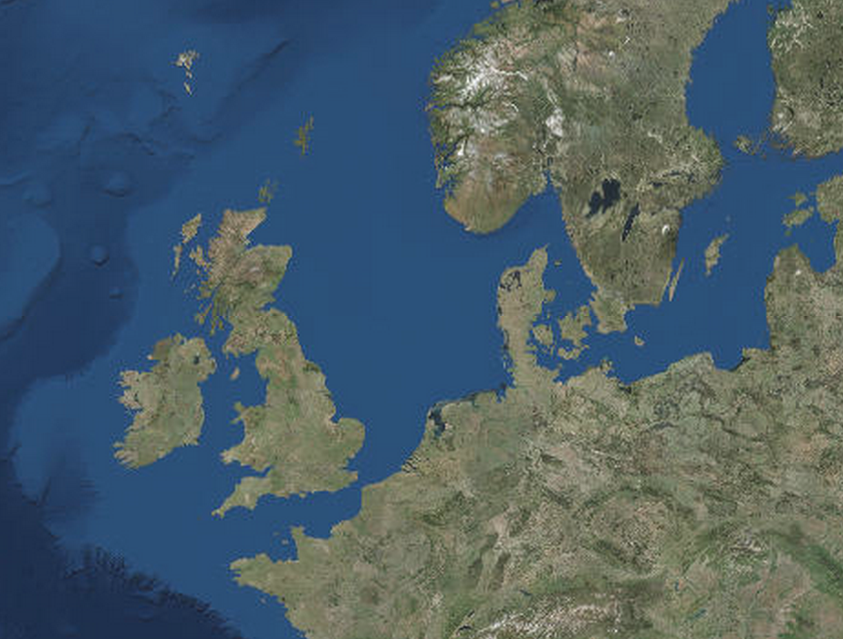
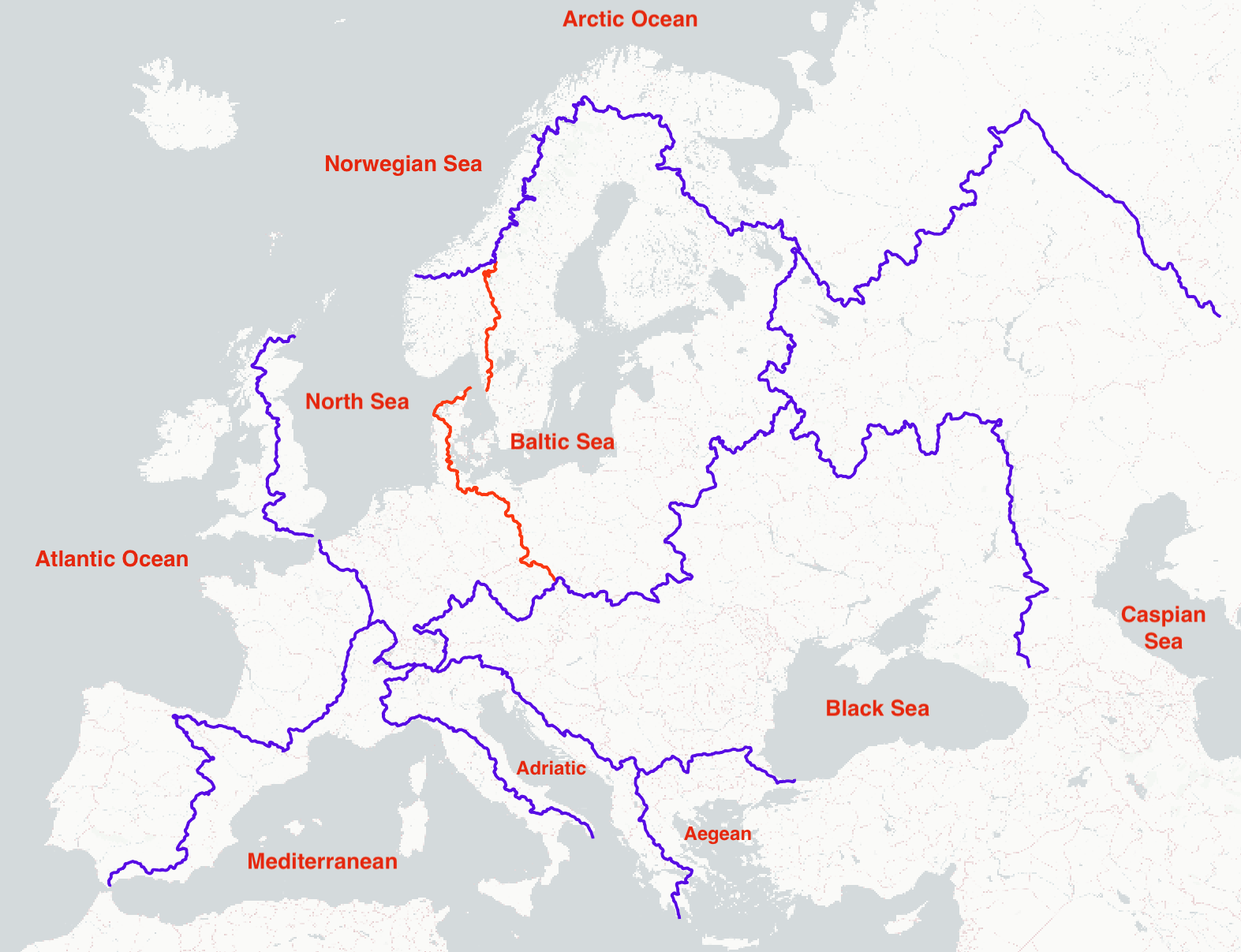
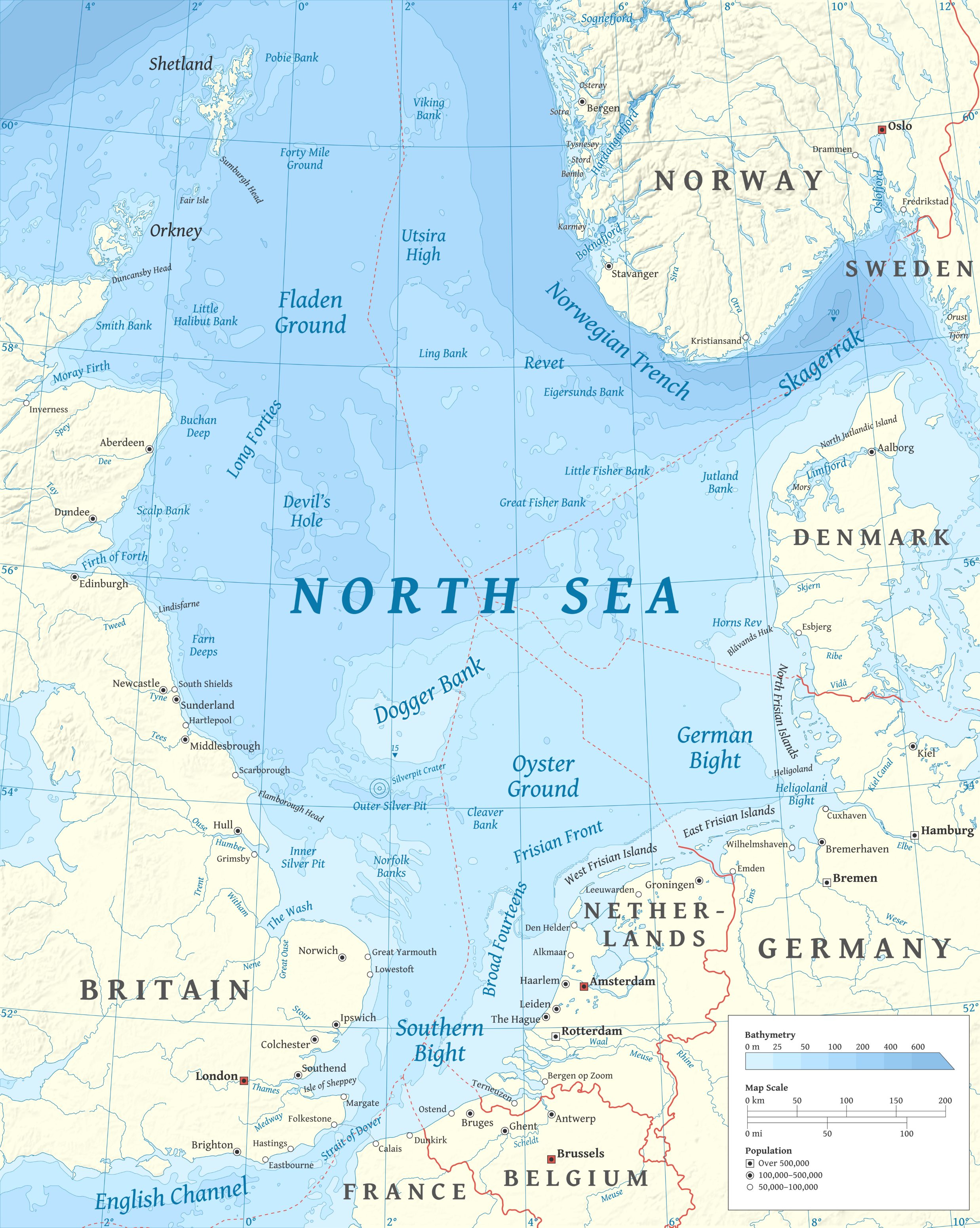
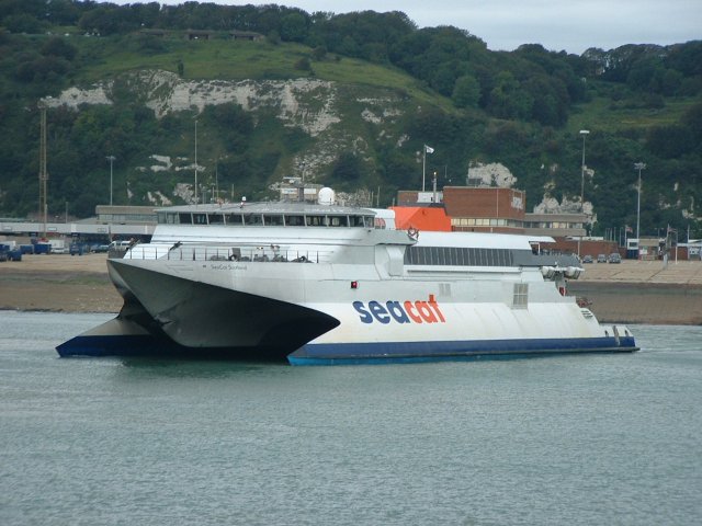
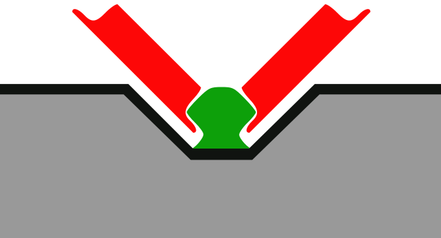
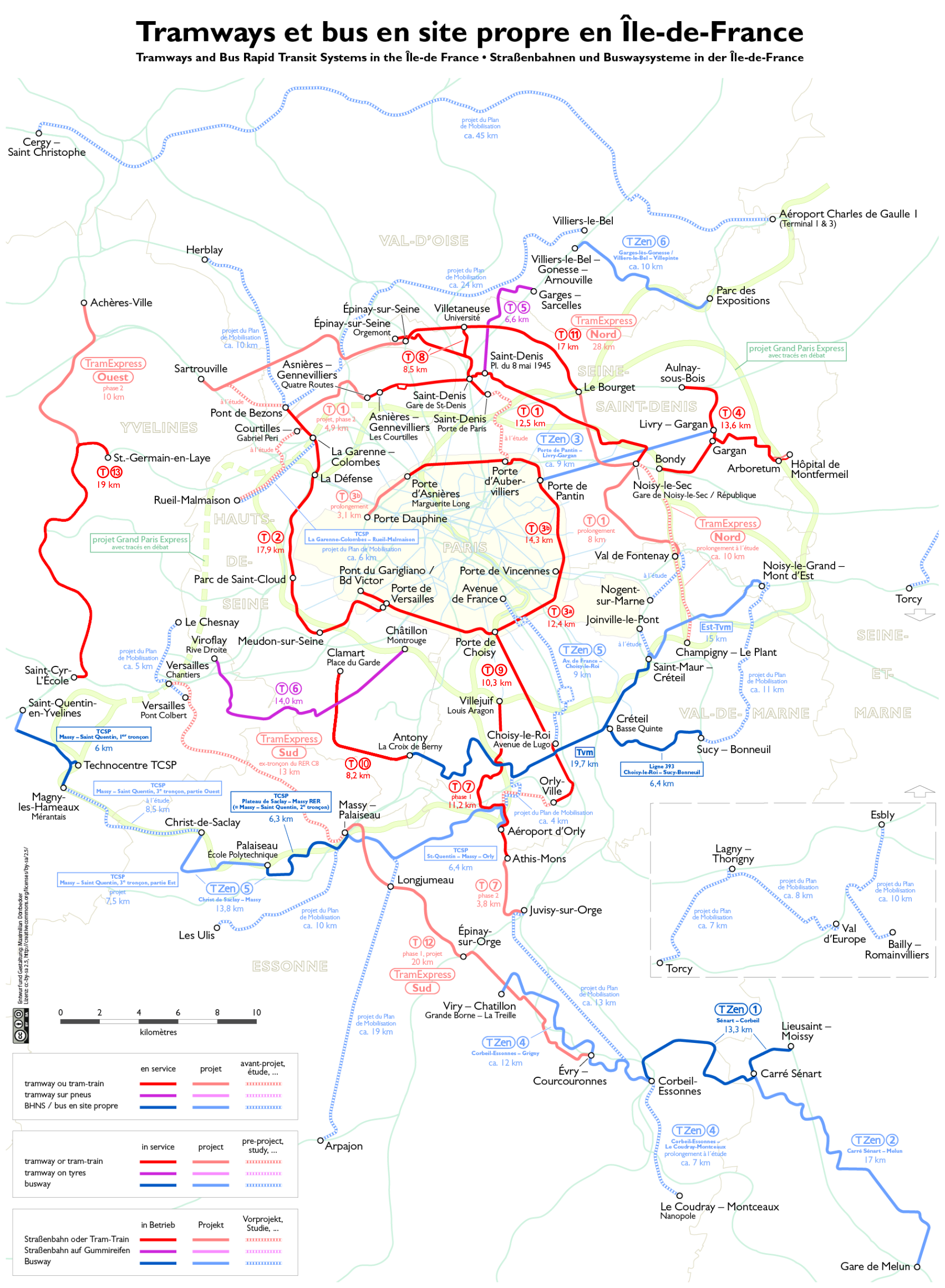
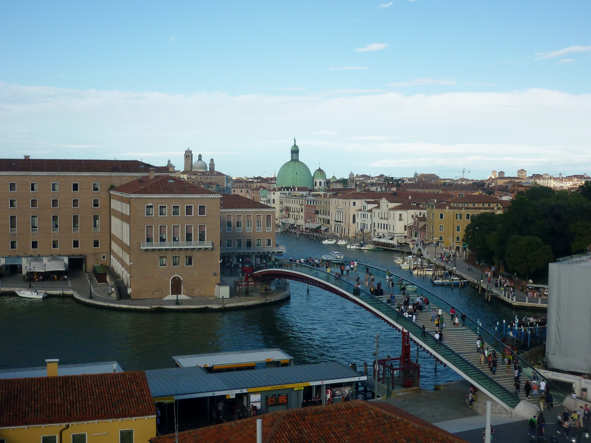
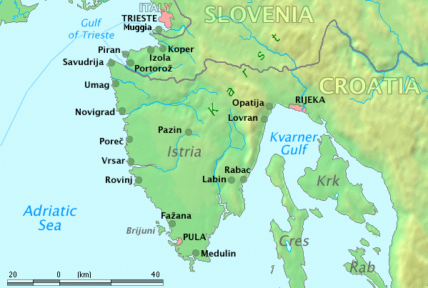