|
Reflections 2022
Series 7
December 7
Street Cable Cars Worldwide II: US Domestic I: Chicago, Los Angeles
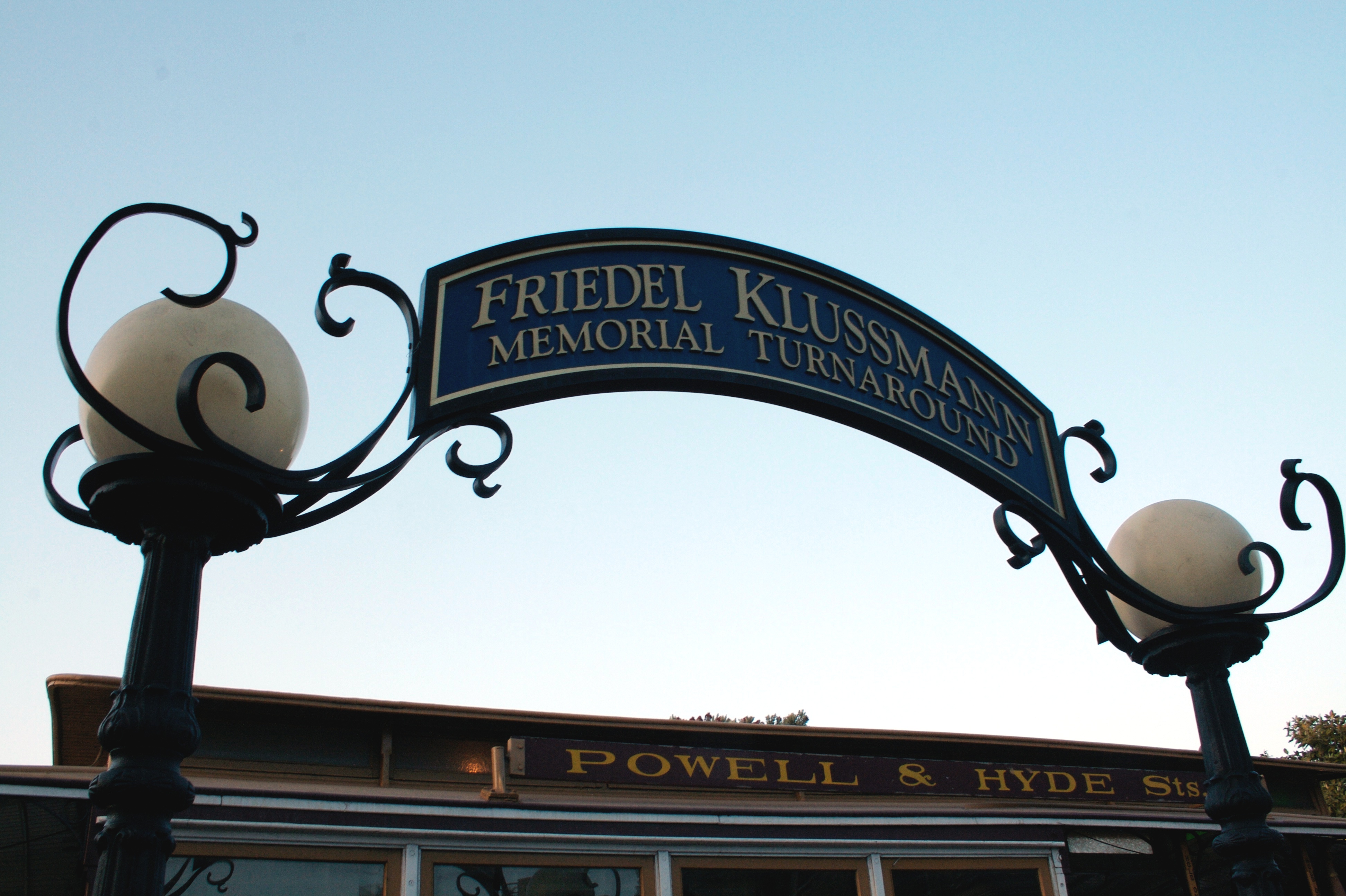
| | Update The day after the last posting came out, I got this very appropriate email from friend Neil Lang, who lives in the Oakland area opposite San Francisco, across the Bay: | | | | | | Your series on San Francisco cable cars was most timely as this week was the celebration of the 75th anniversary of the saving of the cable cars in the city. Yes, the city in early 1947 was all set to replace the few remaining cable car lines with special hill-climbing buses. However Friedel Klussmann formed a coalition of civic groups that successfully passed a referendum in late '47 to require the City to continue cable car service. |
| | | | In 1986, when Klussmann died at age 90, San Francisco cable cars were decorated in black in her memory. In 1997, the city dedicated the turntable at the northern end of the Powell-Hyde line at Fisherman's Wharf to her, calling it the Friedel Klussmann Memorial Turnaround (Photo by Ben Stanfield). | | | | US Domestic Cable Car Systems In the last posting we saw how state-of-the-art cable cars sprang from San Francisco (SF) to a number of international locations, and we discussed specifically five (Dunedin, Melbourne, Sydney, Paris, London), because those were the best documented, with online maps and pictures. In this posting we'll see how cable cars spread across the US, most notably and impressively to Chicago, but also surprisingly to Los Angeles. In the next posting we'll conclude with three systems that really fascinate me in New York, both in Brooklyn and Manhattan.
But first we'll repeat that quote from that 1891 article from The Street Railway Review published—make extra note of this—in Chicago: Chicago was the next to supplant her horses with an iron rope, then Kansas City [MO] and Cleveland, Cincinnati, Denver, Pittsburg[h], Washington, St Paul, Philadelphia, Omaha, Portland [OR], Tacoma, St Louis, and many others, and more recently Baltimore. In addition to that list, I know there were street cable railways as well in Oakland, San Diego, Spokane, Tulsa, Wichita, Washington DC, Providence, Hoboken, and Newark.
But before we get to the big stories, we have some other information worth telling about. There's some very limited information on cable cars in two cities, one of which is Denver.
The Denver Tramway dates from 1886. The term "tramway" is generally not used in the US, and it's not known why the company was named that way. The track was 3 ft 6 in (1,067 mm) narrow gauge, an unusual gauge in the US. The Tramway operated a variety of vehicles, including conduit cars (until 1888; see below), cable cars (until 1900), and trolley cars (until 1950). At the height of its trolley operations, the tramway owned more than 160 miles (260 km) of track and operated over 250 streetcars.
I've found a rather simple, primitive map dated 1892 from the above Street Railway Review showing the Denver Tramway system. The dashed lines show 13 miles (21 km) of cable tracks and the solid lines show 74 miles (119 km) of streetcar tracks. However, by the turn of the century, Denver Tramway had electrified its entire system and was continuing to expand further. This is a Denver cable car in 1895—note the cable slot between the tracks. Of course, it's all gone today.
| | | | | | We're used to seeing electric streetcars/trams/trolleys receiving power via a trolley pole from overhead wires, but the term conduit cars refers to electric trolleys collecting current from an underground conduit, or channel, in the roadway between the tracks, just where cable cars also have their cable. This system is formally called conduit current collection, and was a rare but significant alternative to unsightly overhead power cables. It was widely used in London, Washington DC, and NYC. Using conduits was much more expensive, but necessary where overhead wires were not permitted, including most big cities in Europe. New York City had the largest installation of conduit cars, due to the ongoing prohibition of overhead wires in Manhattan.
Denver's progression was interesting. They started in 1886 with a DC conduit car system, gave up on that and went to horse cars (!), then after two years, went to cable power, competing their first line in 1888. In time came electrification, then abandonment.
Since we just mentioned NYC, take a look at this amazing photo from 1917. We're looking north on Broadway in NYC, just north of Broome Street. While Manhattan did have cable cars (see the next posting), that's not what we're seeing here. Instead we have one of New York's last horse cars (horse-drawn streetcars) before they were banished, as it passes alongside a "modern" conduit car (the conduit slot is visible). Horse cars had always used tracks since they gave a much smoother ride in an era when streets were unpaved, or poorly paved.
|
| | | | The other city where we also have some limited info on cable cars is Seattle, which apparently was a logical choice for cable cars service, given Seattle's steep ridges and hills. I've found this map covering both Seattle's electric streetcars and cable cars as of 1896:
https://i.redd.it/sgn41wbzicn31.png
Locate downtown on the map by finding the merging of routes, and we see immediately that a major ridge facing Elliott Bay, called appropriately First Hill, determines the shape of downtown and shows the need for cable cars to climb and cross it.
| | | | | | Seattle had horse-drawn rail cars from 1884 to 1889; cable cars from 1888 to 1940; and electric streetcars from 1889 to 1941, now all gone. As always with cable cars and streetcars, we have to start getting used to the fact that all the infrastructure we'll be seeing is now gone. |
| | | | This map (click) shows a dozen electric streetcar routes (thick lines) using letter designations, and five cable car routes (thin lines) using numbers. Locate these cable car routes, all of which were founded within four years of each other, between 1888 and 1891:
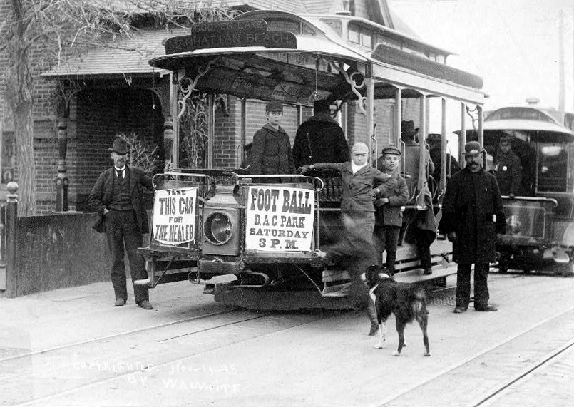
LINE 1 in light gray, rather long, was the Seattle City Railway of 1888. It was originally named the Lake Washington Cable Railway, and ran east on Yesler Way (see below) from Pioneer Square to a park and a ferry dock on Lake Washington, then returned west on Jackson Street. The power house was at Lake Washington and there was one turntable at each end. This 1888 picture of a grip car and trailer was taken when it was still called the Lake Washington Cable Railway, but was operated initially by the Seattle Construction Company.
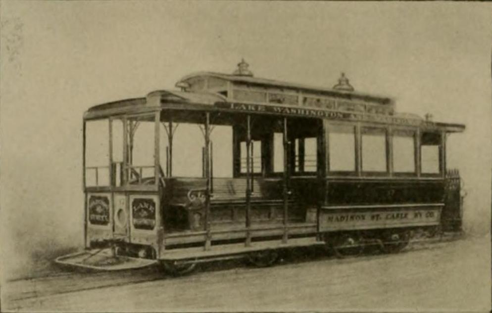
LINE 2 in brown, also rather long, was the Madison Street Cable Railway of 1890, running northeast from Pioneer Square along Madison Street. Here's one of their cable cars, which seems to be the single unit style, with the open grip area up front and closed cabin behind.
LINE 3 in pink was the Front Street Cable Railway of 1889. It was quite short, and seems to supplement an electric streetcar line on Second Avenue. Here are their cable cars in front of their very Victorian powerhouse on Denny Way at 2nd Avenue, which appears to be of the grip-car-plus-trailer style .
LINE 4 in dark gray—surprise!—was the West Seattle Cable Railway of 1890, totally isolated from the rest in West Seattle in the lower left. The caption to this 1895 picture says the car is at its terminus, and that some baseball grounds are to the left of the pavilion.
LINE 5 in navy was the Union Trunk Line of 1891, also downtown on James Street, and seems to be the shortest cable car line of all. This is a cable car in 1900 climbing up the James Street hill from Second Avenue, whose regular streetcar tracks can also be seen. In addition, here's a similar car c1912, oddly, all open-air, further up the hill, at the Hotel Kalmar at Sixth Avenue. The 1881 hotel provided furnished rooms for men who came to Seattle to work. This pair of pictures illustrates well the hilly nature of Seattle, leading to the popularity of adopting its cable cars.
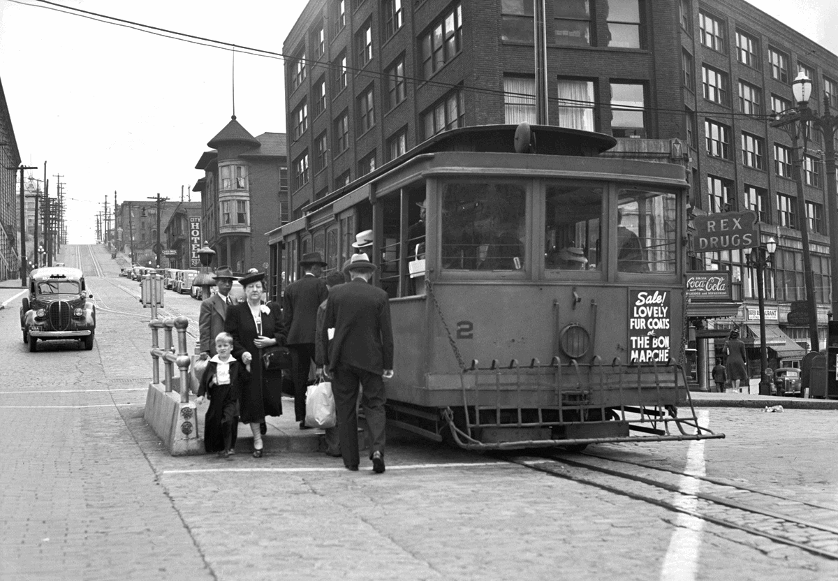
Finally, the newest picture we could possibly have of a Seattle cable car in operation is this one, in 1940. It was taken on 9 August that year, the last line's last day of service (note the cable slot between the tracks). Since it's on Yesler Way (at 3rd Avenue), it has to be Line 1. Actually, the last three remaining cable car lines closed in 1940; the Madison Street line, Line 2, in February; the James Street line, Line 5, in April, and the Yesler line, Line 1, in August. Seattle was the very last city in the US to totally abandon all its street cable railways, leaving of course, only today's three lines in San Francisco.
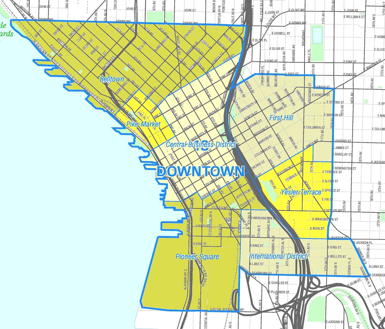
| | | | Yesler Way That's it for cable cars in Seattle, but we have some ancillary information that's juicy enough to continue to hold our attention. We noted Yesler Way earlier on the cable car map. Now let's move to find it on this map of downtown Seattle as we continue (click). And what do we see here? Conflicting street grids separated by Yesler Way. Further inspection shows that every street south of Yesler Way adds the word "south" to its name, so Yesler is a divider. For instance, find Fourth Avenue and watch it become Fourth Avenue South below Yesler. You see tracks. Amtrak's King Street Station is not shown, but it's below S Jackson at S King in historic Pioneer Square, the neighborhood that was once the heart of the city, dating from when the founders of Seattle settled there in 1852.
We immediately notice "grid clash" and see that Yesler separates two very different street grids. This is exactly reminiscent of San Francisco, where Market Street separates downtown from SoMa (South of Market). Here in Seattle, in the 1850s, Arthur Denny and David Maynard, each working independently, each created his own street grid that conflicted with the other. To the north, the Denny approach was to follow the coastline along Elliott Bay, while to the south, Maynard used a strictly east-west layout. The line that is now Yesler Way was established to separate them, and a street formed there.
Henry Yesler arrived in Seattle from Ohio in 1852. He was an entrepreneur in the lumber industry and a politician, and is regarded as a founder of Seattle. He served two non-consecutive terms as Mayor, and was the city's wealthiest resident during his lifetime. Yesler acquired land at what is today near the intersection of First Avenue and Yesler Way, right near the Elliott Bay waterfront. There, in 1853 he built a steam-powered sawmill, which provided numerous jobs. He also acquired as a roadway a swath of land 140 m (450 ft) wide running east from his mill up First Hill, which became, logically, Mill Street (renamed for him Yesler Way in 1903). Mill Street led to a plot of timberland about 4 hectares (10 acres) in area that stretched between what is today 20th to 30th Avenues (the cable car route map gives an idea of that location).
Now to the point: cut logs would be moved down Mill Street (Yesler Way) to his mill from the ever-receding timber line by greasing them, then "skidding" them down the steep hill. For this reason Mill Street acquired the nickname Skid Road. As the city grew, the Skid Road became the demarcation line between the affluent members of Seattle society and the mill workers and more rowdy portion of the population, particularly at the lower end of the street, near Pioneer Square.
In time, the term began to describe in Seattle and across North America (both the US and Canada) any impoverished or disreputable area of a city where homeless people, the downtrodden, and vagrants gathered, the imagery being of things "going downhill". People could be described as being "on the skids" or having "hit the skids". As the phrase spread, it was altered to Skid Row, which is now what the term is considered to be. Nevertheless, Seattle still proudly describes the historic area as the Pioneer Square-Skid Road Historic District, which is on the National Register of Historic Places. Its borders are roughly those shown here, including lower Yesler Way, the Skid Road.
We have "then" and "now" views of Skid Road. In these 1874 views, the top image is from uphill looking west to Yesler's Mill down below at the smokestack. The lower image is from further down Mill Street/Skid Row, showing the Mill, stores, and taverns. In contrast, this modern view is also from uphill looking west on Yesler Way (Photo by dwegner). Downtown is to the right, Pioneer Square and Elliott Bay are straight ahead. The peaked white building is the Smith Tower. This last view is from down below, but looks east up Yesler Way at the Smith Tower (Photo by Joe Mabel). We are on the corner of First and Yesler, right where the mill was in the Pioneer Square neighborhood. Obviously, Seattle's historic Skid Road is no longer a "skid row".
Visualize two things at two different historic periods. First, logs skidding down Skid Road toward the mill, and years later, cable cars of Line 1 going up the hill. All gone.
| | | | Chicago When people talk about the Chicago Loop, they're referring to the famous part of downtown Chicago that has been encircled by a loop of elevated tracks since 1897 (usually called the "el", stylized locally as the "L"), and it was this circular el that gave the Loop its name.
https://ontheworldmap.com/usa/city/chicago/chicago-loop-transport-and-sightseeings-map.jpg
| | | | | | For orientation, on this main map of Chicago, click on the el loop in the center to see the Loop neighborhood, which has the Chicago River on the north and west, and Lake Michigan (beyond parkland) to the east. (Roosevelt Boulevard is considered, less obviously, the southern border.) The el loop is a vertical rectangle with rounded corners running five blocks E/W—Wells to Wabash—and seven blocks N/S—Lake to Van Buren. (For our purposes, we can disregard the two subway lines in red and blue running N/S thru the Loop, under Dearborn and State Streets, which are also el lines once outside of the Loop.) Note how the el lines making the loop also have connecting lines running north, west, and south. We'll discuss the els and Loop in Chicago, where I returned this July, in a future posting. For now, just use this map to orient yourself to streets—and try to mentally "erase" the els as we move back in time before the els were completed in 1897. |
| | | | A few decades before the famous iconic els appeared, other vehicles—cable cars (!)--shuttled passengers around downtown in several loops—six actually. Chicago was the first city in the US to try out SF's innovative cable cars. And they carried a larger number of passengers than SF's cable cars ever did, since Chicago was home to the world’s largest and most profitable network of cable cars. In 1900, Chicago already had the second largest cable car network in the US, after SF.
While cable cars were state-of-the-art technology when the first line opened in 1882, it was then the same old story. By the turn of the century, electric traction had proven superior, since electric streetcar/tram/trolley routes were cheaper to build and simpler to operate, and they started to become the norm. By 1906, all cable routes were changed to electrical power, ending cable traction in Chicago. Most are bus routes today.
Chicago runs north-south along Lake Michigan. This next map shows local neighborhoods, as grouped into larger areas (Map by Peter Fitzgerald). Below is the link to the SAME map, for later reference as to how far from the Loop the cable lines reached:
https://upload.wikimedia.org/wikipedia/commons/b/b3/Chicago_neighborhoods_map.png
Click on the purple area, centered on the Loop, with two adjacent downtown neighborhoods. It becomes clear that, since Lake Michigan is to the east, extended transportation needs would be to the north, west, and south. But also note that the large area west of the Loop is very large, easily broken down to northwestern and southwestern areas, so we'll be finding two routes connecting the Loop with this westerly region, for a total of four entries to the Loop, as shown on this map of Chicago's cable car routes.
http://forgottenchicago.com/wp-content/uploads/2012/12/cable-car-map.jpg
Unfortunately this online map is slightly out of focus and does not expand, but it shows exactly what we need to see: cable car routes connecting to the north (in green); to the northwest and southwest, (both in blue); and to the south, (in red). All cable lines had, instead of termini, loops downtown around several blocks leading to the return direction, for a total of six loops (the northwestern routes had two, a two-block loop, and later an extended four-block loop).
| | | | Three Companies There were three private companies operating 66 km (41 mi) of double-track routes radiating out from the downtown Loop area. This is how the three companies developed—in four directions. In 1859, the Chicago City Railway (CCR), leading south out of the Loop, and the North Chicago Street Railroad (NCSR), leading north, were incorporated, followed in 1861 by a company leading west that later, in 1890, became the West Chicago Street Railroad (WCSR). But these three were meant to provide rail horse car service to and within Chicago. Since all three led in different directions, they weren't in competition with each other. By 1880 all three had main routes with feeder lines, and all three had upgraded from rail horse cars to state-of-the-art cable service.
1) In 1882 the CCR (in red), also designed by the man who did the original Clay Street route in SF, opened successful cable lines--the first after SF (!)--to the south on State Street, which eventually reached 63rd Street at the south end of Washington Park (see neighborhood map). The below CCR cable car is the last preserved example from the era, now at Chicago Museum of Science and Industry:
https://live.staticflickr.com/4350/37265947136_671cbd4f72_b.jpg
They also had a neighboring line on Wabash Avenue, becoming Cottage Grove Avenue, which eventually reached as far south as 71st Street at the south end of Woodlawn (qv).
https://www.geographicsociety.org/wp-content/uploads/2014/09/cover-photo-1500x1034.jpg
https://external-preview.redd.it/6fRDlrT-N6sJe4VhnJ7G4IfTC5rekKxpJighNJm8UG8.jpg?width=960&crop=smart&auto=webp&s=845ca2219932e2107b533ba4995a44f15960e323
The first link shows a cable car on the Wabash & Cottage Grove Avenues line, as the sign says. The second link shows an 1889 hand-tinted photo of CCR cable cars headed south on Wabash Avenue. Note both the horse-drawn wagons, but also the condition of the surface of the street in that era, which is why rail travel was smoother.
The CCR went on to become the largest and most profitable cable car system, and in 1900, it was the largest cable operator in the entire country. In 1887 the CCR alone carried 70,000 to 100,000 passengers a day on approximately 150 trains. By 1892, after both lines had been lengthened, 300 trains were scheduled daily. Three powerhouses pulled thirteen cables. Different cables could run at different speeds; the CCR in the Loop originally ran at 4 mph (6.4 km/h), increased in 1892 to 8.5 mph (13.7km/h), while outlying cables could operate at 14 mph (23 km/h). Find State and Wabash Streets on the main map, and note that the CCR was lucky in that it didn't have the Chicago River to cross.
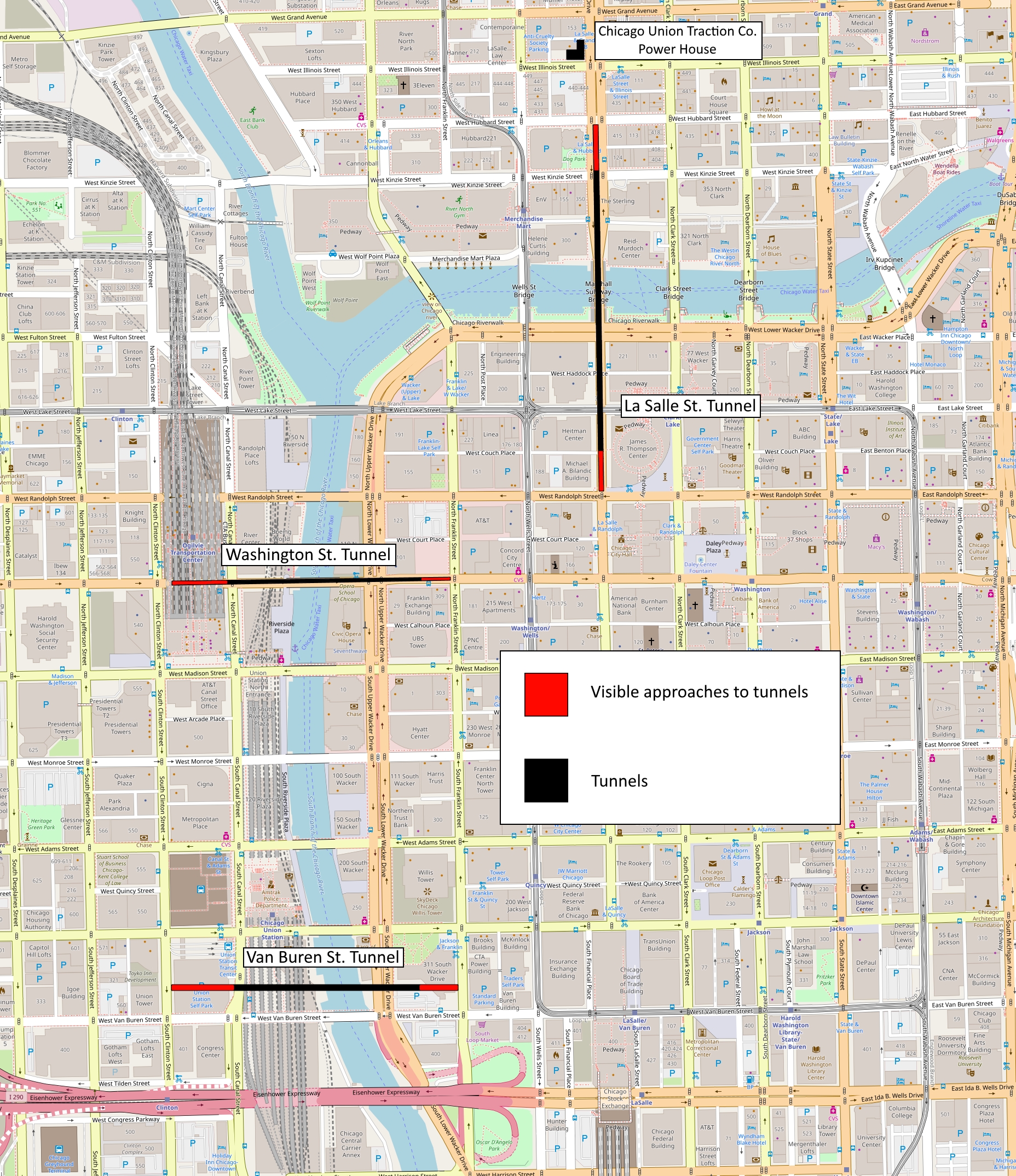
| | | | | | We need to interrupt here to talk about the Chicago River as it affected cable routes, connecting both to the north, and to both western routes. Confirm on our main map that there are numerous bridges in the Loop, since almost every north-south and every east-west street has its own bridge across the river. There is also a lot of boat traffic on the river, and these bridges are all openable. That would be no problem for tracks serving rail horse cars or for those serving electric streetcars. But It's IMPOSSIBLE for a cable to cross a bridge that opens. Even the thought of such a thing boggles the mind. Thus, if cable cars are to cross a river, they have to do it in tunnels beneath the river; there's no avoiding that.
I have to assume that Chicago was unique in that it had at one time, not one but THREE tunnels under the river exclusively for cable cars! It illustrates the importance given to cable cars at the time as being state of the art transportation. This map shows the three cable car tunnels c1906 (Map by Whinke). Below is a link to the SAME map for future reference:
br>
https://upload.wikimedia.org/wikipedia/commons/b/b0/Chicago_Streetcar_Tunnels.jpg
Note again all the (openable) bridges. While it shows the three tunnels, this 1906 map doesn't show the cable car routes themselves, and anyway, by 1900, they'd all been electrified. Yet it does show the els, so one can compare the extensive rail service in the Loop at the time, both els and ex-cable cars, now electrified. We'll give further details on the tunnels as we further discuss the lines.
|
| | | | 2) In 1886, the NCSR (in green), which was the smallest of the three companies, owning about 177 grip cars, many more trailers, and three powerhouses pulling 9 cables, put a cable line into service leaving the Loop to the north on Lasalle Street (see route map), then dividing, going up Clark Street up to Diversey Parkway and also on what is now Wells Street up to Wisconsin Street, both in Lincoln Park (qv). But it needed a tunnel on Lasalle Street. The Lasalle Street Tunnel had been the second tunnel in Chicago after Washington Street, built for pedestrians and horse-drawn carriages, and it had opened in 1871. It was in poor condition, so the NCSR was able to lease and refurbish it for use by its cable cars exclusively.
This stereoptic view shows the south portal (the Loop side)of the Lasalle Street Tunnel, in its original, pre-cable car mode. On the other hand, the below, uncaptioned photo surely seems to be showing the Lasalle Street Tunnel in the cable car era, with cable cars entering and leaving.
https://chicagodetours.com/wp_20/wp-content/uploads/2020/10/Cable-cars005-Lo-Res.jpg
3) In 1890 the re-organized WCSR (in blue) opened its first two lines leading out of Washington Street (see route map). One went northwest on Milwaukee Avenue to Armitage Avenue in Logan Square (qv). The third sign to the left gives the double name.
https://3.bp.blogspot.com/-dnTB-FtBWs4/Wd_ByzHVuaI/AAAAAAAASMo/0CrJeq83kyUG3EnJFJj9aVlvimpt7pUfgCLcBGAs/s1600/052-small-grip-on-Milw.jpg
The other line went due west on Madison Street to 40th Street (???). Below is a Madison Street Cable Car grip car and heated trailer car near Pulaski Road, in West Garfield Park:
https://live.staticflickr.com/1645/24557362522_3144216cc5_b.jpg
But they needed a tunnel as well, and the same thing happened. The Washington Street Tunnel to the west was the first traffic tunnel under the river, opened in 1869 for pedestrians and horse-drawn carriages, but was leaking and in bad shape. The WCSR leased and refurbished it for the exclusive cable car use of their northwestern lines.
We have again a stereoptic view, this time of the east portal (the Loop side) of the Washington Street Tunnel, pre-cable cars. That's then countered by this drawing of the opposite end, the west portal, being used by cable cars at a later date.
https://i1.wp.com/www.365daysofmotoring.com/blog/wp-content/uploads/2017/11/5657696294456.jpg
In 1893 the WCSR planned to open two more routes exiting the Loop just north of Van Buren Street, southwest on Blue Island Avenue to Western Avenue and south on Halsted St to what is now 23rd Street, both on the Lower West Side (qv). But in this case, there was no old tunnel to take over, so the company had to dig a tunnel just north of Van Buren Street at their own expense. These routes terminated west of the river until the Van Buren tunnel was completed in 1894, at which time it ran in an eight-block loop downtown. The WCSR had 230 grip cars and several times as many trailers. Six powerhouses pulled 12 cables.
| | | | Quirks There was a number of unusual features about Chicago cable cars in addition to their rather uniquely using tunnels to pass under a river.
1) There was no standardization of grips, and four different types of grip were used on the roughly 700 grip cars, none being interchangeable between systems. Each company had its own grip, and the WCSR had two, one for its northern system and another for the southern.
2) Another oddity was based on passengers. As with many cities, the problem in flat Chicago was not one of hills, but of serving large passenger volume in a dense city. Sometimes a grip car pulled a single trailer, as many cities did following SF's original mode. But rather than combining the grip car and trailer into a single car, as SF also did on Powell Street, most lines in Chicago used grip cars to pull trains of up to three trailers to carry more passengers, a number that was reduced by law to two trailers in the 1890s.
3) The fact that Chicago had "cable-car trains" led to another curious development. There were no overhead trolley wires in the Loop, I assume banned by the city for being unsightly. So for a while, hybrid cable/electric systems operated, where suburban electric streetcars, arriving at the Loop, had to be pulled by grip cars as part of their trains to cross downtown thru the Loop area.
While it's notable how many historic views have been preserved on postcards, quite a number of stereoscopic views have been preserved as well. This is a stereoscopic view of a CCR cable train going north on State Street from Adams at the turn of the 20C. The train has a short open grip car, a trailer, and is towing an electric streetcar. Click to see the unused trolley pole lying flat on its roof. What a blend of technologies!
| | | | Coasting We've talked about coasting a cable car, actually a somewhat dangerous event due to momentary lack of control, and the subject is very applicable to Chicago. To recap:
(1) When two cables cross at right angles, such as at Powell & California Streets on Nob Hill, if a gripman knows his cable crosses above the other one (Powell), there's no issue. But if the gripman knows his cable goes under the other (California), he has to release the grip before the intersection, coast a bit (usually the intersection is tilted a bit to aid this), then grasp the cable again afterwards. This still is the case in SF to this day.
Now look at the Chicago route map again, and it's obvious that, while the green line never conflicted with the original loop of the upper blue line (presumably planned that way), once the blue line made its loop larger, there were apparently three perpendicular intersections where green crossed blue, and one where blue crossed blue. Each would have involved coasting by the car on the lower cable.
(2) The other early coasting problem, the "let-go curve", was the one that was resolved, as explained and illustrated in the last posting. Here's that text: Early cable cars had been notorious for the gripman having to release the grip and coast when the cable took him around a curve, because the grip couldn't hold onto the cable as the cable went into the grooves around the pulleys. But George Smith Duncan in Dunedin . . . invented the "pull curve", which allowed the cable car to negotiate a curve without letting go of the cable, since a traveling "gripper" held the cable away from the pulleys . . . That invention reached SF and also Chicago, where it was especially sorely needed. Look again at the route map to see that every one of the six loops downtown involved either three or four curves, meaning that early on, each car would have had to coast repeatedly downtown. Thus the Dunedin invention was particularly of use here—problem solved. Here we have a good illustration of a curve:
https://interactive.wttw.com/sites/default/files/images/2017/01/23/001-State-and-Madison.jpg
This view shows a cable car and other traffic competing at State and Madison Streets in the 1890s. This has to be the point where the State Street CCR line starts its northbound loop (see route map). This means that the cable car we see has just come north out of State on the right and has just turned east on Madison, in the distance. By this date it can be assumed that no coasting around this corner was involved, but one can imagine what it would have been like when it was still a "let-go" curve.
| | | | The Demise We know that electric streetcars were destined to take over from cable cars in the long run, here and elsewhere, and sure enough, the Chicago City Council ordered that all cable lines be electrified as of 1905. But another peculiarity in Chicago hastened the cable cars' demise, which is the peculiar story of the Chicago River, a place I was familiar with on earlier visits, and which I finally took a cruise on this past July as part of my Great Lakes trip. We'll discuss the incredible story of the Chicago River when I get to write up this trip on a future date, but in case you're not familiar with that river story, here it is in a nutshell. (Compare the below both on the main map and the tunnel map.)
At about the turn of the 20C, the river had become so polluted that it was a safety hazard, and the solution was an incredible engineering feat. The Chicago River was reversed in its course! On the main map, note the main stem of the river north of the Loop. Where it used to empty into Lake Michigan, we sailed up to see where there's now a lock there to allow ship passage, but otherwise, lake water flows nontraditionally INTO the river, westbound. West of the Loop, the south channel continues that that flow, no longer flowing north, but south. (The north channel of the river at the upper right was never affected and remains as always, flowing south, but of course its waters no longer enter the main stem, but the south channel instead.) There's a lot more to be said here, but we'll leave it to the future posting.
Digesting that that engineering tour de force took place is already a lot, but this next part of the story, not often told, gets even better. When the three tunnels were built, they were located 5.5 m (18 ft) under the riverbed, but in 1900, to make the river reverse its direction, the riverbed had to be deepened, which then exposed the tops of all three tunnels, making them hazards to navigation! Ships actually ran aground on the top of the Washington Street tunnel! In a sense, not only were Chicago's cable cars battling electric streetcars, they were also battling ships!
In 1904 the Federal government declared that all three tunnels were hazards to navigation and had to be removed, which alone cut all cable car service to the north and to both western directions. In 1906 all cable cars were replaced by electric service. The last cable-powered train to run was on the CCR Wabash/Cottage Grove Avenue line in 1906.
It's noteworthy that electric streetcars could cross the bridges, and their routes could be easily diverted, and so all three tunnels were closed for construction. The three tunnels were indeed lowered, converted to electricity, then reopened. The two northern ones were owned by the city, but the Van Buren one had to be lowered at the owner's cost.
The Van Buren Street tunnel was reopened in 1910, the Washington in 1911, and the LaSalle in 1912, all for electric streetcar service. But then the Van Buren had to be closed again in 1915-1916 during construction of the new Chicago Union Station (see tunnel map and click). Still, Van Buren ended regular service in 1924; LaSalle was closed in 1939; Washington remained in regular service until 1952. All tunnels in Chicago, the only ones that ever existed, are now closed and their portals are blocked. All that infrastructure is gone, the cable cars, the streetcars, the tunnels.
https://imagehost.vendio.com/preview/ha/haats/HW1893P169780.jpg
Just for fun, we can close the Chicago story with this drawing from the cover of Harper's Weekly of February 25, 1893, entitled "The Gripman-Chicago Cable Cars". It indicates that Chicago weather is not SF weather, and should evoke a smile.
| | | | Los Angeles Those that know Los Angeles (LA) will wonder where on earth street cable cars could possibly have run there. But that's because LA changed so completely in the mid-20C. What had been a traditional urban structure composed of a central city radiating out into suburbs and connected largely by rail, was transformed, on purpose and mostly in the post-WWII period, into Sprawl City, a smoggy automobile world, where the non-center was indistinguishable from the outer communities.
I've been to LA several times, and enjoyed the many things to do and see there. The Getty Villa, the new Getty, the Huntington, the Norton-Simon, the La Brea Tar Pits, Hollywood, Santa Monica, Beverly Hills, Long Beach, Pasadena, so much more. I remember staying in Santa Monica (nice) and Long Beach—there were other neighborhoods in the area where I stayed—but I had never stayed (until 1993) where you think one would go when visiting a city—downtown. That made LA seem so disorganized, so uncentered. I remember reading in a guide book the question: IS there a Downtown LA? I suspect most visitors, having done what I'd done, are dubious about that. I'll bet even some locals who are weak on local history aren't too sure about that, either, and have grown up assuming LA is a sprawling, uncentered behemoth, different from all other more organized and centered cities. Thus our first task is to see what exists today. After that, we can find the traditional LA beneath it—the one that supported streetcars, and before that, three cable-car lines.
Gertrude Stein famously put down her birthplace, Oakland, across from SF, by saying "there's no there there", and that's very true about LA. Visitors are aware of, and duly check out, neighborhoods within it, like Hollywood, and adjacent cities that seem like neighborhoods within it, such as Beverly Hills, Santa Monica, Pasadena, Malibu, Long Beach. But where exactly is the heart of Los Angeles? Is there one?
Here's a map of what is statistically the Los Angeles metropolitan area, which I consider Sprawl City, a plague that hit the area in the mid-20C with the expanding car culture—you can see that highways are automatically shown, but not any rail connections. It consists of Los Angeles County and Orange County to its southeast (which was part of LA county until it broke away in 1889—so now they're back together again, statistically!). In yellow is Los Angeles proper within its weird city limits shown as a centerless sprawl, with holes like Swiss cheese, and tentacles outstretched like those of an octopus. Hollywood (not shown, NE of Beverly Hills) was taken over as a neighborhood of LA in 1910, but many of the most famous places in the area are obviously independent cities, forming the holes in the Swiss cheese: find Beverly Hills, Santa Monica, Pasadena, Long Beach, Malibu. On first glance, there doesn't seem to be a center. LA appears as a glazed donut, sweet around the circle, but with an empty hole in the center, where you'd expect everything to radiate out from.
This is totally unlike other cities. Take your choice (SF makes a good comparison), but let's use Chicago, since we've just been talking about it. Would anyone go to visit Chicago without spending some time in the Loop, where all routes lead to? Where's LA's equivalent of the Loop?
Maybe this doesn't bother you, but I always like staying in the center of things. That's why I live where it's walkable to where New York was founded, as Nieuw Amsterdam. I've stayed in the very heart of Chicago, Sydney, Melbourne, Minneapolis, Saint Paul, Miami, Boston, New Orleans, Paris, Berlin, and so many other places that come to mind. (This doesn't eliminate outer locations to stay. I LOVED staying in Passy, in western Paris, but I'd already stayed in central Paris more than once.) But why was it so easy to find a nice hotel in downtown Santa Monica, when I'd never stayed in any hotel in downtown Los Angeles? Well, I finally did, on a trip there in 1993. But first I had to find that "invisible" donut hole.
This is a map of Los Angeles County in 1895, six years after Orange County (shown) broke away. While there were plenty of streets and roads, they're not shown—rail routes are shown, a sign of the times. But click and see how all lines merge at a local spot called Los Angeles, and you could take a train from there to, say, Santa Monica, Pasadena, Long Beach, or Anaheim (long before Disneyland). There really was a central point to Los Angeles!
https://i.pinimg.com/736x/74/c3/15/74c315e9ef408fea559bb22c6ed5dc1a--the-neighborhood-orlando-florida.jpg
Now look at this rather decent map, which should help us considerably (of course all travel routes shown are all for cars, including freeways, such as I-5 and I-10). Again we see, now in beige, those cities not part of the City of Los Angeles. Find Santa Monica, Malibu, Beverly Hills, Burbank, Pasadena, Long Beach, and others you've heard of. Then find the in-town neighborhoods you know, like Hollywood, Bel-Air, Westwood. (Note that the city of West Hollywood is independent.) Finally, on the right, you'll find in pink a neighborhood actually called Downtown. We've got it! Not too many visitors are interested in it, and many of them, if not most, have never seen it, or perhaps even wanted to. But there it is.
| | | | Visiting Downtown LA When the '90s arrived, without our realizing it, things started going astray. In 1990, we spent two months in the summer studying advanced Spanish in Málaga, Spain—a memorable, pivotal trip, which for a while seemed to be the end of the Good Times. In '91, Beverly retired, and in '92, so did I. At that point, beginning to notice the decline in her health, I thought we'd never travel out of the country again (that, happily, changed in 2000--but not during the '90s). So in 1993, we decided to take a major domestic rail trip, which we'll limit here to just the part about Los Angeles.
We knew we would be arriving from the east on the Sunset Limited, and a week later heading north on the Coast Starlight, so LA's Union Station would be the center of our plans. Let's finally take a good look at Downtown Los Angeles to see how this trip fit together so nicely:
https://i.pinimg.com/originals/60/d1/fa/60d1fadbfe22b24624b059ffe835a934.png
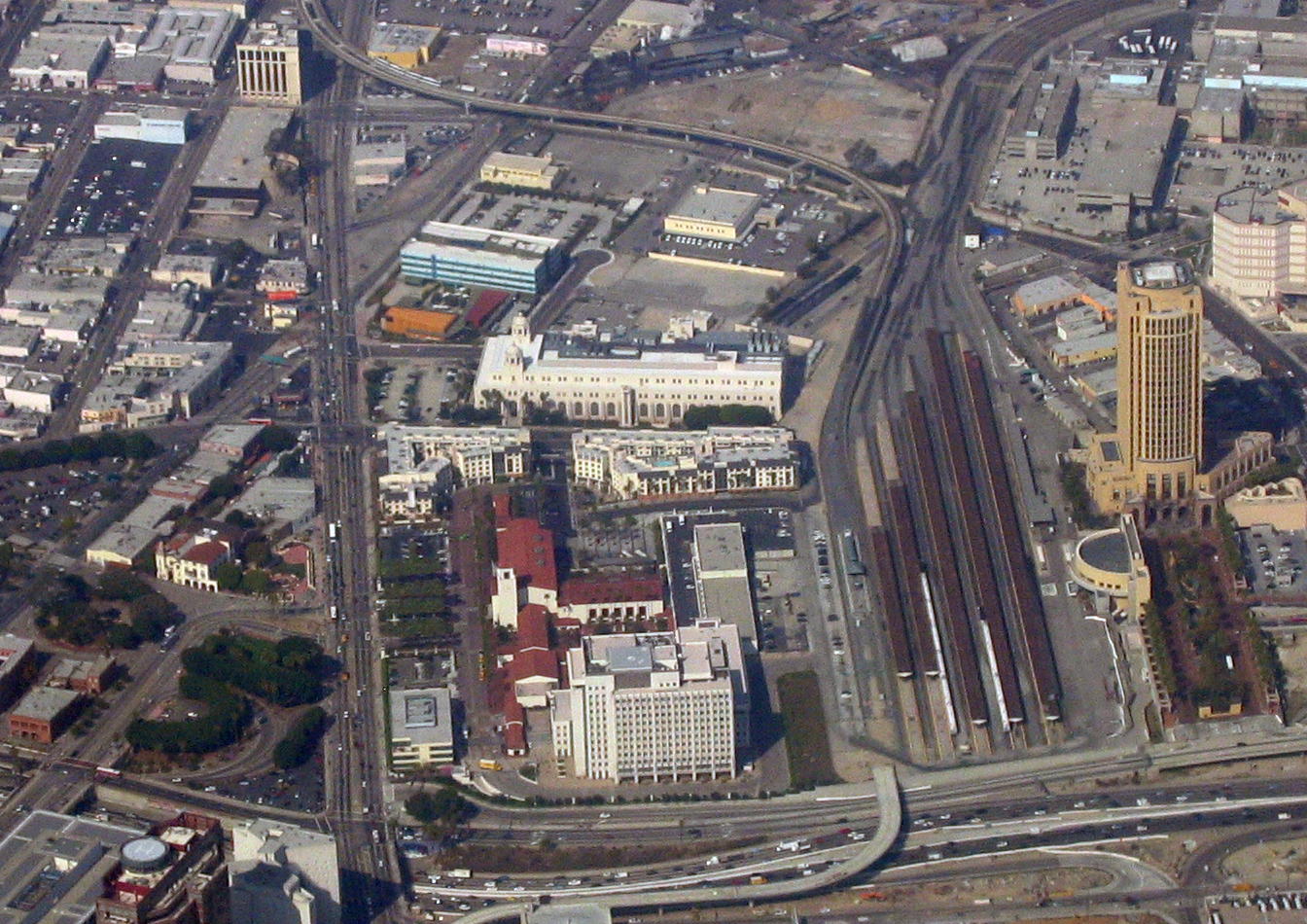
Facing Alameda Street is the spectacular Los Angeles Union Station (click), seen here looking east from Alameda over those tracks (Photo by Basil D Soufi). It's a wonderful place to arrive at—here's the impressive high-ceilinged waiting room (Photo by MichaelJLocke).
Union Station was opened in 1939 to serve three railroads, the Union Pacific, Southern Pacific, and Santa Fe. It now serves Amtrak, Metrolink, light rail, subway, and bus lines. It's the largest passenger terminal in the Western US and is sometimes called the last of the great railway stations in the US. The building combines Art Deco, Mission Revival, and Streamline Moderne style and is on the National Register of Historic Places. It's Amtrak's fifth-busiest station and the busiest in the western US.
| | | | | | FUTURE: Before we go any further about downtown LA, we need to update the interesting current situation about Union Station. Follow the tracks (click) coming into the station coming in turn from tracks up and down the nearby Los Angeles River and you'll find a problem perhaps not foreseen in 1939 when the station was built as a terminus. But today, both Amtrak and local Metrorail use the station, and there are traffic problems—sometimes trains have to wait north of the station for a track to become available, and, perhaps worse, trains have to back out of the station! Therefore, there is an extensive rebuilding of the area currently being done. There's new landscaping, and new retail services being built at the station, making it even more of a hub. But there are two rail changes of great importance.
https://www.enr.com/ext/resources/Blogs/Gold-Rush/link_us_project_component_map.jpg?height=635&t=1518102751&width=1200
First, there's a new southern entrance/exit being built for Amtrak and Metrolink trains, changing its status from a dead-end terminus to an actual station (that word always implies a run-thru situation). The above view looks east from Alameda over the station building. The purple area to the north is the current entrance/exit, being improved, and the orange area is the new passenger concourse. But the purple area on the right is the new entrance/exit, connecting, over the Hollywood Freeway (US 101), to the tracks along the river, both ways. This will allow trains to enter and exit from the south, and also to use a loop track to turn around to return to the station. The yellow route indicates further connections to the west. Compare these plans to our main downtown map.
The second change involves the arrival of high-speed rail at Union Station. I don't believe final plans are made yet, but I've found two options:
http://s3-us-west-2.amazonaws.com/media.thesource.metro.net/wp-content/uploads/2013/04/10200755/aboverailyard.jpg
This drawing (click) suggests (in green) putting the high-speed tracks above the conventional tracks, running both north and south of course, with a special concourse (in dark blue) for HSR passengers.
The other suggestion I've found is to run the HSR tracks under Vignes Street east of the station, with its own passenger concourse, connected to the rest. Check out Vignes Street on both this map and our main map.
We also have a short (2:11) YouTube video presenting the changes at Union Station.
PAST: That's the present leading into the future, but we should also say a word about the rail past here. The word "union" always implies a connection of routes for passenger ease that hadn't existed earlier. So just what did LA Union Station replace in 1939? Two other stations a bit to the south, La Grande and Central.
http://www.losangeles.citysam.de/stadtplan-losangeles/stadtplan-little-tokyo-2.gif
This map (the "yellow map") shows a larger area south of Union Station. Find where 2nd Street joins the appropriately named Santa Fe Avenue. This is where the Santa Fe Railroad had its La Grande Station from 1893 until 1939.
Now find 5th Street and Central Avenue. This was the location from 1914 to 1939 of Central Station, the Southern Pacific's main passenger terminal, whose name was doubly appropriate. (It had replaced the wooden, Victorian Arcade Depot nearby on Alameda between 5th & 6th that SP used from 1888 to 1914.)
The Union Pacific Railroad, whose main station, built in 1891, had been damaged by fire, also began operating out of Central Station in 1924.
All this came to an end with the building of Union Station in 1939. But do note how all the stations discussed were/are located just east of the numbered street area of the traditional Downtown Los Angeles.
|
| | | | Back to our 1993 trip. It was the only time we used downtown as a base, and our first day in the area was memorable, one reason being that it was totally walkable! Walking in LA! How unique! We had booked a very pleasant hotel right across from Union Station. I remember its location clearly, but had to look up its name again—and it's still there! It was the Metro Plaza Hotel on North Main Street. On our main map, find where that street bends sharply to cross over Alameda and that's where the hotel was—so close to Union Station! A four-minute walk. It's on the west side of that northernmost block of Main, north of Chavez. | | | | El Pueblo It was a matter of having prime sightseeing (if you like history) right outside your hotel, in addition to the historic Union Station. Immediately south of the hotel was El Pueblo de Los Ángeles Historical Monument (Historic District), the oldest part of LA. It's where in 1781, settlers founded the town (el pueblo) originally called by the lengthy name El Pueblo de Nuestra Señora la Reina de los Ángeles [del Río] de Porciúncula / The Town of Our Lady Queen of the Angels of [the] Porciúncula [River]. Thus the town was named after the Los Angeles River, and the original name of the river refers to a chapel in Italy where Franciscans believe their order was founded (Franciscans built the mission).
Today, the main point of interest is Olvera Street (see main map), today a one-block long paseo / pedestrian mall (Photo by NewtonCourt). At the southern end of Olvera is the historic Plaza, the apex of the old city center, today the Historic District.
| | | | | | By the 1920s, this entire area was a run-down slum which the city wanted to condemn and destroy. Wishing to preserve California's heritage, a non-hispanic Californian, Christine Sterling, began a campaign to renovate the 1818 Avila Adobe House on Olvera in 1926, which was extended into making Olvera Street a modern Mexican-style marketplace. It has been argued that Olvera is a sanitized version of Latin American culture meant for tourists, which is true as far as it goes, but historians also have preserved the various sites for historic study.
I found a note in the travel diary saying that on that day we visited the thick-walled Avila Adobe House, dating from 1818, making it the oldest surviving residence in Los Angeles. These pictures show the quality of the restoration, and the historic value of the house: the kitchen; the living room; the bedroom (All Three Photos by Bernard Gagnon).
|
| | | | The Historic District—El Pueblo--was the downtown under Spanish, Mexican, and US rule, which started in 1847 and ran thru most of the 19C. On our main map, the Pueblo area runs from Chavez south to the freeway, and, edging out from Alameda, includes Los Angeles, Main, and Spring Streets.
Before we cross to south of the freeway, use this aerial view (Photo by Ron Reiring) to summarize what we've seen so far. The red roofs center bottom (click), facing Alameda, with the tracks to the right, indicate Union Station. The freeway abuts it. Note the greenery across Alameda. The leftmost green circle is the historic Plaza. Olvera Street is the one block to its north. Across Chavez, the blue-roofed angular building at the end of Main Street was our well-located hotel.
| | | | Victorian Downtown Los Angeles To continue with the first day of that trip, but also to begin to understand where on earth cable cars could have run in LA, we move south of the freeway and come to what is best described as Victorian Downtown Los Angeles. I think our main map will be clearest to follow, but you may also wish to refer to our yellow map, the one that shows a larger area.
During the 19C, as the population of nascent LA grew, a street grid was laid out to the south of the Pueblo area, which is now south of the freeway. Typical were the numbered streets one would expect. We said the Pueblo area had covered Los Angeles, Main, and Spring Streets; by the 1880s and 1890s, the center of Victorian LA shifted a block or so west and spread along Main, Spring, and Broadway south to Third Street, the latter two shown in blue on our main map.
At this point in the late 19C, the intersection of First and Spring Streets was the center of the business district. But by 1910, the area north of Fourth Street was considered merely the less-favored North End of the business district and there were already fears about its deterioration. This lower-numbered area is now referred to as the Civic Center.
| | | | Historic Core Of the several areas in Victorian Downtown Los Angeles, we'll talk about two, the first being the Historic Core. In the early 20C, between 1907 and 1931, the commercial hub moved further south, and larger buildings were constructed along Broadway and Spring from about Third to Ninth Streets in what is now called the Historic Core.
https://silverlakeblog.com/wp-content/uploads/2016/04/BID-Boundary-Map-Corrected-979x758.jpg
The Historic Core (above) was the city's main commercial street for the first half of the 20C, into the 1950s. It included former large department stores and office towers, and is also notably the location of the Broadway Theater District, the first and largest historic theater district listed on the National Register of Historic Places. With twelve movie palaces located along a six-block stretch of Broadway, it is the only large concentration of movie palaces left in the US. The below map shows eight of the locations.
https://www.seeing-stars.com/Theatres/BroadwayTheatreMap.gif
But starting in the 1950s, what is now the Historic Core started to decline. Upscale shopping had moved west to other areas. Streetcar lines were thriving (more in a moment) which allowed customers and workers to live away from downtown, yet reach it easily. Then more and more consumers had cars (the eventual downfall of downtown), and lived, worked, and shopped locally. After WWII, financial institutions moved to western downtown. The movie palaces began to show cheap-budget, horror and sensationalist films, then began to go out of business, the last one closing in the 1990s. However, some of them have been taken over, renovated, and now used again for major films, including premieres.
| | | | Bunker Hill The other area we need to mention in connection with cable cars is Bunker Hill, which is an entre neighborhood as well as an actual hill. On our main map, find Broadway between 2nd and 4th. The next two streets west are the appropriately named Hill, then Olive. The top of the hill was originally between Hill & Olive, 2nd & 4th. The neighborhood is larger. One concept of the neighborhood borders is this:
https://goodheartcatering.com/web/image/2119/Bunker%20HIll%20Downtown%20Los%20Angeles.png
The summit of Bunker Hill proper started as a residential suburb, and was a wealthy neighborhood up to WWI. In the '20s and '30s, once again the extensive streetcar system plus the plague of freeways drew the wealthy away to enclaves such as Beverly Hills and Pasadena. In those year, once-stately Victorian mansions on Bunker Hill were dilapidated, and served as rooming houses. From about 1930 onward, numerous venerable buildings downtown were demolished to make way for street-level parking lots, which is another way that cars hurt downtown--the high demand for parking making this more profitable than any other options allowing preservation.
Bunker Hill was tunneled thru at 2nd Street in 1924, then at 3rd and 4th Streets. In 1940 the freeway opened (CA 101 on the map) and by 1953, its four-level interchange downtown increased the auto culture's power to finally suck life out of the area. In 1955, Bunker Hill itself was lowered in elevation, and for a number of decades, the entire area was redeveloped to replace older buildings with modern high-rises and other structures for a variety of uses, notably new entertainment venues.
To end talking about our 1993 trip, I remember that we then walked around the Victorian Downtown, and got the impression of abandonment, some homelessness, and a number of drab locations. The diary reminds me that as we walked south of El Pueblo, we walked along the Civic Center Grand Park to the Music Center, and took a look at well-known venues such as the Dorothy Chandler Pavilion and Mark Taper Forum. We also went to the Bunker Hill area to see how that is being modernized. (On another visit entirely, I particularly remember walking past the Walt Disney Concert Hall at night and realizing how deserted the neighborhood felt.)
But a partial day was enough for this area, and so we picked up our reserved rental car and drove west. In the evening, tho, we went to a Mexican restaurant on Olvera Street to complement the day's activities. We stayed a total of seven nights at our hotel and drove off "everywhere" in the metropolitan area, in all directions, and saw everything we wanted to. Suffice it to say that in that week in LA we put 980 miles (1,577 km) on the rental car, which shows how sprawled out the area is, and how nowadays with the (cable cars and) streetcars gone, a car is the only real way to do your own private touring. In the end, we then left Union Station northbound on the Coast Starlight.
| | | | Los Angeles Cable Cars Now that we're all on the same page as to what LA's downtown area had looked like, we can finally discuss the cable car system it once had in this area at the end of the 19C when cable cars were thriving. And now that we know that Bunker Hill sat right downtown surrounded by slopes, we begin to see why cable cars had an advantage, as they still do in San Francisco.
Cable car street railways, a total of three companies, first began operating up Bunker Hill in LA in 1885 and, as was also typical elsewhere except in SF, lasted for just 17 years, until 1902, when the lines were electrified and many other electric streetcar lines were introduced, which largely followed and extended the cable car routes. There were roughly 40 km (25 mi) of routes, connecting First and Spring with outlying communities. By 1920, the city's private and municipal (electric) streetcar lines were the most far-flung and most comprehensive in the world in mileage, even besting that of New York City. Remember that fact, because those streetcars were the extended descendants of the cable cars.
The very first cable car system in Los Angeles was the Second Street Cable Railway. Opened in 1885, its single route ran northwest along Second Street, starting at Spring and up, over, and down Bunker Hill to where Second merged with First Street to the west (see main map).
http://libraryarchives.metro.net/DPGTL/maps/1889-temple-street-cable-railway.JPG
This route map shows that it went beyond that merger some distance to the west of downtown. However, in the upper left side of the main map find the piecemeal Boylston Street and where it (namelessly) crosses Second. Then refer to the route map and you'll see that's where the powerhouse was--by eye, at about roughly the midpoint of the route, which continued to the west. The completed railway was 2.1 km (1.3 mi) long. It was a single track system (remember Paris?), with sidings where a down-hill car could coast past an up-hill car. (!) The route included the steepest gradient on any street railway in North America, a 7.7% grade along Second Street on Bunker Hill. This is a view to the west from the terminus at Second at Spring showing a cable car of the Second Street Cable Railway in 1886. Click to see the incline up Bunker Hill ahead.
The railway was created to encourage sales of property west of downtown Los Angeles, but was plagued with flooding problems and damage to cables and pulleys. In 1889, another flood caused further damage to the line, and it was abandoned in 1890 at the age of only five years. With its demise, the Second Street Cable Railway had the distinction of being the first cable railway in the US to go out of business.
The second cable system was the Temple Street Cable Railway, which began service in 1886. Temple is the first street north of First (see main map). The route map shows that it started at Temple and Main, and, being 2.7 km (1.7 mi) long, went quite a distance out of downtown. Its powerhouse on Temple and Edgeware was in about the Boylston Street area. This is a view to the west down Temple from Broadway showing a cable car of the Temple Street Cable Railway in 1890. Note the very Victorian houses on Broadway, and the horse-drawn carriage. The large building on the northwest corner is the "temple" of the Women's Christian Temperance Union, which gave its name to the street, and then to the cable railway. An electric streetcar company bought this company and replaced the cable cars with electric streetcar service in 1902.
The third system was the Los Angeles Cable Railway, which operated the system with the greatest length at 33 km (21 mi) of track, of which 30 km (19 mi) were straight surface track, with the rest on viaducts and bridges.
http://libraryarchives.metro.net/DPGTL/maps/1889-los-angeles-cable-railway-cable-car-lines.JPG
As of 1888 it operated six routes I've seen described, one being from 1st Street north up Main and North Broadway to Chinatown (see main map and route map). Another was from downtown east to today's Boyle Heights (see route map). I cannot reconcile the other routes with this small, hard-to-read map, but it does show cable routes running in four directions.
This is a view to the south on Broadway from Second Street showing a cable car in 1893-5, presumably of the Los Angeles Cable Railway. You can see the cable slits between the tracks, and that this was a two-way route. Again, note the Victorian architecture and the horse-drawn carriages (click). I count 44 stars on the US flag, which I checked, and is accurate. This flag was valid until 1896. Yet to come were six more stars for Utah, Oklahoma, New Mexico, Arizona, Alaska, and Hawaii.
This is a detail of the car, showing it connects with "Downey Avenue" on the "City Limits". I find Downey is well to the south of downtown. Note the long dresses, and the conductor riding the running board.
Los Angeles also had significant investments in cable technology. The Los Angeles Cable Railway (later named the Pacific Cable Railway) owned many exclusive franchises agreements to city streets and had constructed several major cable lines crisscrossing the growing downtown area, considered the latest word in cable railway technology. But construction was expensive, legal and operating problems plagued the system, and new technological developments threatened to make the system obsolete--which they did, when all cable routes went electric.
Normally we would stop here, but what happened in Los Angeles is especially egregious, and we have to pursue this a bit further to see how the electric streetcar descendants of the cable cars disappeared. There were two electric street rail systems, the Yellow Cars and the more famous Red Cars.
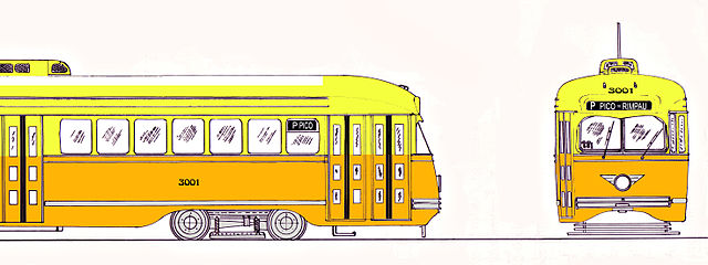
| | | | Yellow Cars The Los Angeles Railway (LARy), commonly called the Yellow Cars, was an electric streetcar system that operated from downtown Los Angeles into surrounding neighborhoods between 1895 and 1963. The company's nickname indicates that it was well known for the distinctive yellow livery of its streetcars. The original color scheme was two-tone yellow, with a lighter shade for the roof (Image by Voogd075 at Dutch Wikipedia), which was modified later on. The management of the new company purchased new cars, and also began converting all the existing horse car and cable lines to electricity, which was completed in 1896. At its height, the system contained 20 streetcar lines and 1,250 trolley cars, most running through the core of Los Angeles and spreading out to many other neighborhoods on 1,033 km (642 mi) of track. The Yellow Cars carried three times as many riders as the Red Cars despite serving only a 6 mi (9.7 km) radius around their downtown headquarters. Their service actually complemented the Pacific Electric "Red Car" system's mostly interurban routes (see below), which largely served commuters in a much larger area of Los Angeles, which was more sparsely populated.
This is a slightly stylized map of the numbered routes of the LARy trolley system (Image by Pi.1415926535). Downtown you'll recognize such names as Spring, Temple, 2nd, and 3rd Streets, and also notice the system served the former Central Station on Central Avenue. Another source indicates that those main north-south streets served downtown are Broadway, Spring, Main, and Los Angeles Streets.
| | | | | | Here's an odd quirk. LARy created two unique Yellow Car funeral streetcars to serve the area's cemeteries. The first, a smaller one, was rebuilt from a passenger car in 1909, but was converted back in 1911 when a new, larger funeral car was created from a passenger car. It was used until 1922 when it, too, was converted back, and the original funeral car was re-rebuilt and took over once again. It was available for chartered use by funeral parties at a cost of about $25. It was designed with a compartment that opened to reveal a special folding casket carrier. The family sat with the coffin in an interior with touches that included stained-glass windows (see below picture). It was all very dignified, designed to accommodate people who wanted to avoid a bumpy ride over unpaved roads in a horse-drawn cart on their way to the cemetery. The funeral car was retired from duty in 1924 as private automobiles took over the funeral trade—as they did everything else.
https://live.staticflickr.com/3686/9398930810_7930af966f_b.jpg
I've read that San Francisco also had funeral streetcars, and Chicago, famous for its elevated train system, had funeral el trains that took mourners accompanying caskets to cemetery station stops in specially designed funeral cars at a rate that reached 22 trips per week in 1907.
|
| | | | Red Cars The Pacific Electric Railway Company (PE), commonly called the Red Cars, was an interurban rail company that was the largest electric railway system in the world in the 1920s. It operated for the six decades from 1901 to 1961, sporting its distinctive red livery (Photo by Oleknutlee at English Wikipedia). | | | | | | The Interurban (called a radial railway in Canada and Britain), is a type of electric railway with streetcar-like, electric rail cars running within, but mostly between, cities or towns. They were very prevalent from 1900 to 1925 in North America, and were used to connect passengers between center cities and suburbs and exurbs. In the pre-automobile era, electric interurban rail was the most economical way to do this. |
| | | | The Pacific Electric Red Car electric interurban streetcar system was organized around downtown Los Angeles, spreading in all directions, but also around downtown San Bernardino far to the east, as shown in this map (Map by jkan997). It connected locations in four counties, Los Angeles, San Bernardino, Riverside, and Orange Counties. The extent may be clearer in this stylized map of the system as it existed in 1926:
https://preview.redd.it/ma24h10ptui11.png?width=960&crop=smart&auto=webp&s=f8ef446b045acf0b1100dbcc9d747cd3ada232f6
Click for details on this map regarding the following: these were the days when you could connect by streetcar from Santa Monica in the west to Riverside in the east, or from the San Fernando Valley in the north to Orange County in the south. We'll show again the same view of the former Central Station in LA. That green canopy in front of it was to protect passengers waiting for the next Red Car (or Yellow Car), who, arriving cross country by rail, wished to connect to interurbans and other streetcars to complete their journey within the metropolitan area.
| | | | | | We really must include here this stylized companion map to the last one, made by the same person:
https://i.redd.it/07qdfyjufg221.png
It shows how the freeways of modern LA have very closely duplicated the PE Red Car system across Los Angeles, San Bernardino, Riverside, and Orange Counties, whose names are more clearly indicated here. It does seem like a trade-off of electricity for gasoline, which occurred after WWII, when politicians from local municipal governments, Los Angeles County, and the state, agreeing that a massive infrastructure improvement program was necessary, agreed to construct a web of freeways across the region. This was seen as a better solution than a new mass transit system or an upgrade of the PE.
|
| | | | While the Red Cars were standard gauge (1,435 mm [4 ft 8.5 in]), the Yellow Cars were narrow gauge (1,067 mm [3 ft 6 in]). This resulted in a curious situation not often found. In 1890, Los Angeles passed the so-called five-block-law, which allowed any streetcar company to use another company's rails (or right-of-way) for up to five city blocks. For that reason, the Yellow Cars and Red Cars shared dual-gauge trackage in downtown LA (right in front of the terminal at 6th & Main), and on 4th Street, and along Hawthorne Boulevard to the south toward Hawthorne and other cities (see route map). | | | | | | Here's a quick review and illustration of dual gauge. Any combination of narrow, standard, and broad gauge in the same right-of-way requires more than a simple pair of tracks. Simplest is three tracks, but four is also possible (two narrower tracks between two broader tracks). This is an illustration of a three-track dual gauge layout (Illustration by SCHolar44). There's a common track on the right (which would wear out faster due to more use) and on the left, corresponding tracks at two distances away. In this case, the purple wheels and axle (narrower) illustrate standard gauge (1435 mm), and the pink ones (wider) broad gauge (1600 mm). Now make this mental adjustment for the Los Angeles streetcar situation. The purple standard gauge is the same (1435 mm) but the pink is now narrow gauge (1067 mm), so the left pink wheel is about the same distance to the right of the purple one.
How that played out on a public street in Los Angeles can be shown by this similar dual-gauge tram picture in Liberec, northeast of Prague, in Chechia (Photo by cs:User:ŠJů). The dual gauges here are standard and meter (1435 and 1000 mm). Looking ahead on the left is a single pair of standard gauge tracks, but looking ahead on the right is a set of dual-gauge tracks, with the common track on the right. Coming in from the right and crossing it immediately is another set of dual-gauge tracks, connecting interestingly with those first tracks in the far left.
|
| | | | The Big Transition The LARy system became the property in 1944 of National City Lines, a holding company that was purchasing transit systems across the country. National City Lines, along with its principal investors, including General Motors (a leading maker of buses as well as cars), Firestone Tire and Rubber Company, Phillips Petroleum, and Standard Oil of California (now Chevron), were later convicted of conspiring to monopolize the sale of buses to local transit companies controlled by National City Lines and other companies in what became known as the General Motors streetcar conspiracy. Included were allegations that they conspired to own or control transit systems in violation of Section 1 of the Sherman Antitrust Act, and had plotted to dismantle streetcar systems in many US cities in an attempt to monopolize surface transportation in favor of buses and cars. In Los Angeles, the argument was that they conspired, roughly in the two decades between 1945 and 1965, to destroy and eliminate LA's extensive streetcar network replacing both the iconic Yellow Cars and Red Cars with buses. Doing so would also increase the demand for cars, plus tires and oil.
Testimony was given that GM and the others "killed the streetcar", and that the layers of smog that began to beset the city were due to their taking over the local transit companies, scrapping the pollution-free electric streetcars, tearing down the power cables, and ripping up the tracks to add GM buses to the already congested streets.
However, while I for one relish this conspiracy theory, there are indications that to some extent, it is, sadly, if not an urban legend, then at least an exaggeration. While it's undeniable that GM and its partners had been engaged in an aggressive campaign to change transportation modes, it wouldn't have been feasible if the streetcar companies National City Lines was purchasing hadn't already been struggling (in LA, they owned the Yellow Cars, but never did own the Red Cars belonging to Pacific Electric [PE], which went into a decline with the rest.) Apparently in the 1930s, LA's streetcars had become severely unprofitable and were losing riders, and the Red Cars had been profitable in only one year between 1913 and the start of WWII. Then during WWII, transit ridership rose because of gas rationing, but declined again between 1945 and 1951, when ridership dropped by about 80 million people.
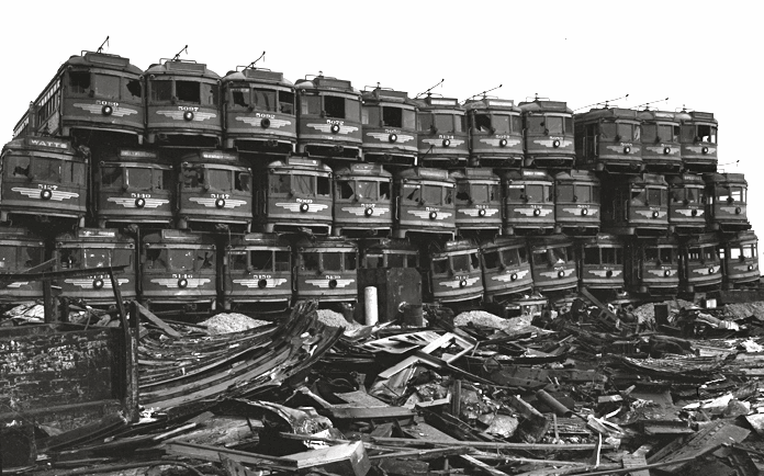
This 1956 picture, which might as well be called "PE Graveyard", is a dramatic illustration of the junking of the Red Cars (and others, elsewhere), as they wait to become scrap metal, all while the internal-combustion engine took over from electric traction, some of which was descended from cable cars. It marks the transition in the mid-20C from one more traditional Los Angeles to the one we have today.
| | | | Metro Rail Human folly being what it is, we should not be surprised that what gets destroyed might very well make a comeback and get rebuilt later on, when people realize the folly, tho at much greater expense. In the case of LA, in 1990, LA County founded Metro Rail, an urban rail system serving the county. It's been extended significantly, and further extensions are either under construction or being planned. What goes around, comes around. In 2021 the system had a ridership of about 47.9 million; as of 2022, the weekday ridership is 170,100.
This is the route map of Metro Rail as of October 2020. As of January 2020, route nomenclature was changed. When I rode the system some years ago, all routes were still named for colors, but now they're all letter names, as shown in the map inset. Metro Rail consists of seven lines serving 99 stations. Five lines are light rail (A, C, E, K, L) and two are subway lines (B & D). It connects with the Metro Busway bus rapid transit system (G & J lines), Metrolink commuter rail, and several Amtrak lines. And irony abounds. Metro Rail uses many of the former rights-of-way of the Yellow Cars and Red Cars, and thus can be considered their indirect successor. Sweet.
In 2007 I did my "Southwestern United States" trip, reported over three postings (2007/14-15-16), and the third posting tells of my stopping in LA. It was one of those visits where I stayed at hotels around the area—three, actually. I stayed in Long Beach for a ferry trip to Catalina overnight, then stayed in Santa Monica and finally moved on. However, Metro Rail was new to me, so, when in Long Beach (see route map), I wanted to try it out. I took the Blue (A) Line (light rail) downtown, then connected to the Red (B) Line (subway) to revisit Hollywood for a bit, before returning to Long Beach. It was a pleasure to travel across the LA area by rail, and not via a traffic-choked freeway (with which I'm unfortunately quite experienced).
I chose the Blue Line because it went where I wanted to go, because it gave a lengthy ride to sample, but also because its route had been both the first and the last interurban passenger line of the former Pacific Electric Red Car system, and served the longest, from 1902 to 1961. The Blue Line uses its right-of-way, is a true successor, and was the first Metro Rail line to open, in 1990. This is a car on the Blue Line headed south back to Long Beach as it leaves the Willowbrook/Rosa Parks station (Photo by David Wilson).
We have one more major US cable car location, New York, where we'll discuss both Brooklyn and Manhattan cable cars, in the next posting.
| | | |
| |
|
|
|

