|
Reflections 2023
Series 7
December 3
SE Florida I: Miami's Late-19C to Early 20C Settlement
| | The Great Deviation My most recent trip to South Florida was in November 2019. In the posting of 2019/18, we discussed the (happy) change of a planned trip to Cuba and the Caribbean into a trip to South Florida. That posting also discussed Henry Plant and his rail routes to Tampa and the west coast of Florida.
The next three postings, 2020/1-2-3 all discussed Henry Flagler and his railroad's affect on the east coast of Florida, heading toward Miami, plus the layout of Miami and its rail renaissance.
The topic of a possible boat train connection between Brightline and cruise ships in the Port of Miami got us off topic and into discussing boat trains in Europe, which moved on to so much more. But now, after an incredible deviation of four years and one month, we now move back on topic. I've put a note at the end of 2020/3 drawing the reader's attention to the current continuation.
| | | | | | By the way, over these intervening years, Brightline is up and successfully running as the only privately owned and operated intercity passenger railroad in the US (Photo by BBT609). Furthermore, in the last posting, we talked about the planned Brightline West service running from near Los Angeles to the Las Vegas Strip. |
| | | | The rabbit hole I fell into was the additional talk at the time that some trains might, within Miami, connect Miami Central directly with the Port of Miami to service cruise ships. (Update: this never happened!! They now tell you to take a taxi!) Since "rail 'n' sail" is a favorite topic, this possibility of combining the two at what was traditionally called a "boat-train" got me talking about past boat-train service in France and England—and we never got back to Florida. We went on with all kinds of topics, such as the Orient Express, Agatha Christie and, most recently, street-cable cars, but left this subject hanging.
Oh, but it got worse. Aside from keeping 2019's 29-night Florida trip up in the air (Downtown Miami! The Keys and Key West! Miami Beach's South Beach's Art Deco world!), I also allowed discussions of all travel since then to back up. In the pandemic year of 2020, it was only one night away (a lifetime record), but 2021—just 5 nights away--included a Lower Hudson Circuit, then a "spite trip" for a wonderful visit to Dearborn's Ford Museum & Greenfield Village. In 2022 I did my twice-pandemic-postponed Great Lakes Rail 'n' Sail for 20 nights. The current year of 2023 I'm down a bit, to 8 nights, including the 7 nights sailing to Bermuda the second week of September. In addition to that, I have extensive online notes on several topics not bound to travel dates, including a juicy one on airships like the Graf Zeppelin and the Hindenburg. Will I ever catch up?
Well, it's time to start, and so we go back, pre-pandemic, to November 2019. (As you know, it's called Covid-19 because it broke out in Wuhan in December 2019.) I find I'd done four postings on Florida, 2019/18, plus 2020/1-2-3. (The one after that was the first of two on Boat Trains!) There is no need to go back to catch up, as I'll now present a short synopsis of those four postings so that we're all "on the same page". If you don't need these short synopses, jump down to "The Fairy Tale".
| | | | Recap: 2019/18 This posting was called A Failed Trip to Cuba-Its FL Replacement–An Uncommon Snapshot of FL-Plant & Tampa. It started with the fact that I felt it my duty to take advantage of Americans legally being able to visit Cuba, and had found a trip out of Fort Lauderdale on Holland America's Veendam. I didn't really want to go to Cuba, because I'd traveled enough behind the Iron Curtain in Europe to countries with heavy restrictions, and it's really not much fun. Also, the Caribbean is not my favorite place to go, with a couple of exceptions (Curaçao, for one). The trip I found included a couple of repeats, plus some new stops that only visited resorts, which didn't interest me. The other abomination of the trip was a "fake" island in the Bahamas. I like the Bahamas, but this was some flyspeck of an island with a couple of palm trees that the cruise company had spiffed up with a curved ("half-moon") beach and "renamed" for tourist purposes Half Moon Cay (say "Key"). I grudgingly went along with this poor choice of a trip.
Then, early in 2019, on 5 May, I saw an article in the Times that the Trump administration was reversing the Cuba program instituted by the Obama administration, and shortly afterward got my deposit back from Holland-America. This was surely the only thing the Trump administration ever did that ended up pleasing me. I then altered my plans so as to instead revisit the three locations in southern Florida described above instead. One oddity of this is that the Veendam, on its new altered itinerary, ended up making a one-day stop in Key West when I was there, and so I went to see it from the dock. That was a fun quirk.
Included in "An Uncommon Snapshot of Florida" was my division of the state into three historic areas of settlement: what I call in the north the Panhandle Plus, reaching over to Jacksonville and Saint Augustine, the historic area of settlement, from the Spanish to the Civil War days; in the south, the unique maritime area of the Keys and Key West, noted for its Bahamian architectural style; and the remaining Peninsular Florida, which most people avoided back in the day as an area of hot weather, alligators, snakes, swamps, and mosquitoes—part of it was actually called Mosquito County. Keep this map for reference:
https://www.orangesmile.com/common/img_city_maps/florida-map-0.jpg
While the American West was settled by Conestoga wagons, Florida was settled by two railroads. Henry Plant sent his down the west coast to Tampa, where he built the Tampa Bay Hotel. His trains went on to Port Tampa, where his ships sailed to Key West, Havana, and beyond.
| | | | Recap: 2020/1 This posting was called Flagler & the Florida East Coast RR - Saint Augustine - Palm Beach. It tells how Henry Flagler built his Florida East Coast Railroad (FEC) from the north, via Jacksonville and Saint Augustine, including the needed bridge over the Saint John's River, all the way down to West Palm Beach, with a branch to Palm Beach on the local barrier island, where he built his own mansion, Whitehall. Both Henrys famously built resort hotels all along their routes, with the Breakers in Palm Beach still in existence. The sprinkling of settlers along the coast always urged Flagler on to build further south, but it's logical to think that settlers in southeast Florida might have believed that, with Flagler having built his personal residence in Palm Beach, that was a sign that that was as far south as he was planning to go. And as the Florida map shows, Palm Beach and West Palm are already considerably further south than Henry Plant got when he reached Port Tampa, and then resorted to his ships to go further. | | | | Recap: 2020/2 This dealt with the Everglades – Tamiami Trail - Miami/Dade County – Miami Downtown: Two Grids. I first explained that we'd be dealing with history in southeast Florida sometimes out of chronological order. We'd cover three periods of interest: downtown Miami today; in its heyday of the 1920s; and in the 1890s, when Flagler and the FEC arrived in Miami to greet Julia Tuttle and the Brickells, names we have not yet discussed.
From the posting, here's "a map centering on Everglades National Park. Follow Tamiami Trail [an older highway connecting Tampa and Miami] east, and see where Krome Avenue marks the de facto western boundary of the urban area. Straight ahead US 41 goes down SW 8th Street / Calle Ocho, but a turn to the south on Krome could get us to a street like Kendall Drive to visit relatives, down to Homestead and Florida City, where the main entrance to the National Park is, or further still, to the Keys. Entering the NP, you see how the park road in red leads, with many stops along the way, to the Visitor Center at Flamingo on the edge of Cape Sable. We'll discuss more later how the Main Park Road, including the short extension out to Florida City numbered State Route 9336, was, in the early 20C, the main highway connecting Flamingo, with some variations, all the way to Miami." Flamingo today is a ghost town hosting the Park's Visitor Center, but before the Park was established in 1934, it was a village first settled c1892, and the section of the regular Miami-Flamingo road that fell within the park boundaries became the park road. We mention this because of upcoming Flagler involvement. We pointed out that Monroe County is in two pieces, with the bulk of its territory in the western Everglades and the balance comprising most of the Keys. Dade County covers the eastern Everglades, but has been consolidated with Miami, and is now known as Miami-Dade County.
In addition, we said a lot about Downtown Miami today, as well as its growth in its heyday of the 1920s. Refer to the posting if you wish to review that. What remains is to talk more about the cast of characters in the formation of Miami in the 1890s.
| | | | Recap: 2020/3 This covered Miami Downtown: Rail Renaissance. Here we started with Flagler's route into Miami, how it prospered, then declined. Finally, we look at the modern changes with the comeback of passenger rail service to the metropolitan area. This includes the Government Center station coupled with the new Miami Central Station. We can summarize Miami rail today as follows.
This is a map of the Metrorail system (Map by Howchou), which has routes from downtown going northwest and southwest. Attached to it, but here in detail, is the Metromover system (Detail Map taken from original design by Howchou, updated). This is a free mass-transit automated elevated people mover. Despite our recent conversations about cable, the Metromover is NOT run by cable traction, but is electrified. The two systems merge at two points. Even this rail map already shows that Miami has two de-facto downtown areas, the traditional one north of the Miami River (ex-Tuttle land) that flourished in the 1920s, served by the Government Center station, and the developing one south of the Miami River, Brickell, (ex-Brickell land), served by the Brickell station.
But that's just for the metropolitan area. Given Miami's squeezed location along the coast, you'd expect passenger rail to run north and south. But we have to sadly eliminate consideration of passenger rail service to the south beyond the metropolitan area. That's what Flagler spectacularly managed to do at the turn of the 20C, and it's gone now. That story will involve a later posting.
Going north, tho, we said there are two possibilities, because there are two rail corridors. It's easier to describe first, then a map will follow. Closer to the shoreline is the Florida East Coast Rail Corridor, heading back in time to Flagler. It's still privately owned by the successor company to the FEC. This is what Brightline has used for its new service, which uses the new Miami Central Station, directly connected to the Government Center station above. Brightline serves six locations up to Orlando—see below--with plans to turn west and serve Tampa. They've also talked about someday going north to Jacksonville.
Miami's (distant) NW 37th Avenue is the route of the former Seaboard Air Line (SAL) line, now the state-owned South Florida Rail Corridor, a bit further inland than the other corridor, with the present (outlying) Amtrak Station lying directly on the tracks of this main line. Also on that corridor are the Tri-Rail commuter trains, owned by Florida. Now let's put the whole picture together (Map by FrickFrack).
https://upload.wikimedia.org/wikipedia/commons/8/87/Miami_Metro_Map_2017.png
Don't scream. This 2018 map is simpler than it appears at first. On the lower left, eliminate the Metrorail lines in orange and green. On the lower right, eliminate the Metromover lines in blue and purple.
In the center, find the Government Center/Miami Central complex. Going north out of that in yellow is the Brightline route on the FEC Rail Corridor, serving Miami, Aventura, Fort Lauderdale, Boca Raton, West Palm Beach, Orlando.
On the upper left is the South Florida Rail Corridor, which is the route Amtrak uses arriving from the north. Just before it crosses under Metrorail is the present (remote) Amtrak station in gray.
| | | | | | I connected to Metrorail at this point on the 2019 trip being described, then changed at Government Center to the Metromover to Knight Center and directly into my hotel. Returning from Miami Beach a couple of weeks later, I used a local bus (no rail!) to Government Center, then Metrorail to the Amtrak Station. Details in another posting. |
| | | | At this intersection, Tri-Rail goes to Miami Airport, shown in blue. However, the pink line shows that it's planned to go to Miami Central downtown, unifying all rail. This is shown more clearly here:
https://www.miamiherald.com/news/local/community/miami-dade/47emi0/picture33654405/alternates/FREE_1140/09-03-TriRail
On this map, Miami Central is still referred to stupidly as the "All Aboard" station. But it shows the present remote Amtrak station clearly and how the route shift is planned to FEC trackage. However, this map hopefully says this shift should happen in 2017. Current talk says it should happen in 2023, which is rapidly coming to an end, so don't hold your breath.
This concludes the recap of past postings.
| | | | The Fairy Tale While we still have not defined our cast of characters, we still can talk about them, specifically about the fairy tale about the founding of Miami—less sharp critics will simply call it a legend. People like the story because it's simple, sweet, and fun. The fact that much of it is just a pretty story and not fully true is just a bothersome detail. I will admit that in the past, I passed this fairy tale on to others as gospel.
Once upon a time, there lived on the north bank of the Miami River a woman named Julia Tuttle, and she, like many others, wanted Flagler to extend the FEC further down the coast so that their real estate would flourish. At one point in the late 19C, there was a great freeze in central Florida (Florida freezes do happen—I've experienced them in Tampa) and there was extensive damage done to the orange crop because of it. But southern Florida was not so affected. So one fine day, Julia Tuttle supposedly cut some boughs from orange trees with healthy fruit and sent them to Flagler to show the advantages of a warmer climate. Taken by this, Flagler decided to extend his railroad south, and they all lived happily ever after.
But of course, no great business deals take place so simplistically. So what did happen? Were oranges and boughs sent at all? If so, who sent them? And who are all these people?
| | | | Cast of Characters We've been mentioning names—now let's see who's who. There are five. Some of this info I've salvaged from 2020/1, but most is new. And there is one thing that will strike everyone as very odd: the ongoing coincidental connection between all these players and the city of Cleveland, Ohio. It's just uncanny. So we'll start in Cleveland.
JOHN D ROCKEFELLER was born in 1839 near the Finger Lakes in New York. In 1853, the family moved to Cleveland. In 1851, Cleveland commission agents and produce shippers Isaac Hewitt and Henry Tuttle, operating as the new firm of Hewitt & Tuttle, received the first cargo of Lake Superior iron to reach Cleveland. In 1855, at age 16, and a high school graduate, Rockefeller got a job as an assistant bookkeeper at Hewitt & Tuttle. In 1859, while still 19, he left and went into business for himself, forming a partnership with a neighbor as Clark & Rockefeller, commission merchants in grain and other commodities.
HENRY FLAGLER was born in 1830--so he was about a decade older--also in the Finger Lakes Region. At age 14, he left school after the 8th grade and, not wanting to burden his poor family any further, he walked to the Erie Canal in 1844 and took it to Lake Erie, and then went to Ohio via a lake steamer, ending up in Bellevue, west of Cleveland. Flagler and Rockefeller met in Bellevue when Rockefeller was buying grain for his commission house and Flagler was a grain merchant, and in 1867, they became partners in what was now called Rockefeller, Andrews & Flagler. This latter firm eventually left the grain business and invested in oil, and later became Standard Oil, which, by 1879, did about 90% of the oil refining in the US.
JULIA TUTTLE is the only one of the five that was actually born in Cleveland. She was born Julia Sturtevant
in 1849, making her a decade younger than Rockefeller, but two decades younger than Flagler. She was the daughter of Ephraim Sturtevant, a professor. In 1867, she married Frederick Tuttle, the son of Henry Tuttle of Hewitt & Tuttle, so her father-in-law had been Rockefeller's first boss at that firm, tho by now, Rockefeller had been running his own business for eight years.
WILLIAM BRICKELL was born in Steubenville, Ohio, on the Ohio River, in 1825, so he was the senior of our group and 24 years older than Julia Tuttle. At the age of 24 he headed to the West Coast of the US to strike it rich in the California Gold Rush of 1849. After three years there, in 1852 he headed to Australia with his partner Adam Kidd to chase more gold in a little-known gold town called Yackandandah. They hoped to find gold there but instead, soon established themselves as businessmen in nearby Albury, where Brickell made his fortune, not from gold, but from selling supplies to the influx of gold seekers to Australia and building hotels for them to stay at. You've surely heard other stories of fortunes made by suppliers, rather than gold seekers, at gold rushes in California and the Yukon.
| | | | | | Below is a map of Victoria that also shows a large part of New South Wales:
https://ian.macky.net/pat/map/au/vic/vic_blu.gif
Albury is about halfway between Melbourne and Sydney. You see the rail route I took thru Albury when we discussed it in 2010/13 regarding the former break of gauge there (a problem now solved) and Mark Twain's humorous comments on the matter. Albury is on the north (NSW) side of the Murray River that forms the border between NSW and VIC, with its twin city of Wodonga on the south (VIC) side.
https://www.weather-forecast.com/locationmaps/Albury.10.gif
This more detailed map shows that Yackandandah, affectionately known as "Yack", lies in VIC, today about a half-hour's drive south of Albury.
|
| | | | Brickell and Kidd had numerous money-making ventures, including owning a general store and what was then the Exchange Hotel. They won the contract to build Albury’s first Union Bridge across the Murray River, opened in 1861. They had a stage coach company to shuttle miners to and from Melbourne and also to the gold fields. They owned a punt service on the river, from which they made a lot of money. When I read this fact, it seemed odd to me, since I understand punts to be pleasure boats--in England, I've watched punters standing in, and navigating their punts with long poles on the Cam River in Cambridge. But it turns out, after researching more deeply, that in Australian English, a punt is a cable ferry, a type of service we've discussed in the past, where a chain pulls a small ferryboat across a river. An Albury historian says they made a huge profit from the punt service alone.
MARY BRICKELL was born Mary Bulmer in Yorkshire, England in 1836, making her about a decade younger than William and just 13 years younger than Julia. At the age of 3 she moved to Australia. Mary and William met in Albury. That Albury historian suspects that Mary may have worked for William in his hotel, but that is speculation. William and Mary married in Melbourne in 1862 and the next day began the three-month ocean journey to the US. Thus, the fortune William made in Albury later financed the purchase of land in Florida, so there is at least a historic financial tie between Albury and Miami. However, at first the Brickells did decide to move to Cleveland and open a wholesale grocery business. Thus Mary joined the other four who had a Cleveland connection. However, while the others were all American, Mary, at least in the beginning, was an Australian of English heritage. But do not underestimate Mary. Not only did she outlive them all, she eventually became a well-known Miami real estate mogul. But we'll get to that.
There are some additional miscellaneous facts that I've gleaned. Tuttle and Rockefeller were church friends in Cleveland as well as knowing each other thru the old business firm. Flagler and the Brickells were also church friends. There was a report that Tuttle and William Brickell first met in Cleveland as well. In addition, it's suggested that Brickell lent the fledgling Standard Oil money, and tensions rose when the loan was not repaid. But I do not have details.
| | | | Cleveland We've said our cast of characters centered on Cleveland, so let's see what that looked like more or less when they were there in the mid-to-late 19C. This is Ohio in 1850. Across Lake Erie, Ontario was still called Upper Canada. On the south shore, click to find Cleveland (old spelling) in the yellow county. In the northwest in yellow is Bellevue, where Flagler and Rockefeller first met on business. In the east, in green, on the Ohio River, is Steubenville, where Brickell was born.
When I was on this Miami trip in 2019, I hadn't ever been to Cleveland, but since then, in my 2022 Great Lakes trip (not yet posted), the ship stopped there for a day and I explored the city, so I now have more of a feeling for it. I walked the downtown, centered in the historic Public Square and learned how Euclid Avenue was one of the wealthiest enclaves in the US at the time, with the mansions of millionaires all along its length (mostly now torn down, recycled, or replaced by commercial structures). I took a city bus the length of Euclid to Lake View Cemetery on my usual quest to see Presidents' graves, in this case, Garfield's. By chance, just steps away was also the obelisk at John D Rockefeller's grave, so I also made a quick stop there (Photo by THD3).
| | | | | | From the 1860s to the 1920s, Euclid Avenue was internationally known for its beauty and wealth including a string of mansions that came to be known as Millionaires' Row. Baedeker's Travel Guides called the elm-lined avenue "The Showplace of America", and designated it as a must-see for travelers from Europe. The concentration of wealth was unparalleled; the tax valuation of the mansions along "the Avenue" far exceeded the valuation of New York's Fifth Avenue in the late 19C. Accounts at the time compared it to the Avenue des Champs-Élysées in Paris and to Unter den Linden in Berlin.
https://thumbs.worthpoint.com/zoom/images5/1/0920/12/vintage-millionaires-row-cleveland_1_759c8c609f6d01150cdb4124424aa655.jpg
https://thumbs.worthpoint.com/zoom/images3/1/0920/12/vintage-millionaires-row-cleveland_1_759c8c609f6d01150cdb4124424aa655.jpg
These two links are part of a collection of drawings of some of the mansions on Euclid, notably Rockefeller's.
|
| | | | Now let's take a look at Cleveland in 1862, roughly as our cast of characters would have known it. Click on the upper center to find historic Public Square, and leading out of its southeast corner is Euclid Avenue (here called Street). The best-known Euclid Avenue resident was John D Rockefeller. Follow Euclid almost to the two-mile radius, then back-track two blocks. His home was at Euclid Avenue and Case Avenue (today called East 40th Street). Flagler's mansion was just a very short distance away on Euclid—I have no address--so they could easily work together. I have no indication where in Cleveland Tuttle or the Brickells lived, but being wealthy, Euclid Avenue would have been a good possibility for both.
https://i.pinimg.com/originals/f4/2d/75/f42d752154f78be849d3c0c273f1d76e.jpg
https://i.pinimg.com/originals/67/ac/bd/67acbd8cf6c395a14ca5962c6fad3bc2.jpg
The first link shows a generic view of Euclid Avenue "Millionaire's Row" mansions back in the day. The second link shows Rockefeller's mansion on Euclid at Case (E40th), built in 1868.
| | | | Dade County We can now continue with the other half of the Cleveland-Miami connection and how it all started with Miami and its region in Dade County in the 1890s, when the area was incredibly different from how it is today. Again, Dade County is now called Miami-Dade County to take advantage of the international recognizability of the Miami name.
Even by the end of the 19C, Florida, especially Peninsular Florida (the "wasteland") had very little population, and so the counties formed were very large. In addition, borders between counties were often changed. Dade County was created in 1836. At the time of its creation, it was huge. Use this modern map of Florida counties to see the area in question (Map by Radom1967). Early on, Dade County also included the land that now contains Palm Beach and Broward counties, together with the Florida Keys from Bahia Honda Key north (all but the furthest Keys—check Florida map). Only the westernmost Keys were in Monroe County. In 1866, the remaining Keys from Key Largo west went to Monroe County, as this map shows. Thus, Monroe County has two disconnected sections, and therefore lies both west and south of Miami-Dade.
In 1880, the settled population, other than Native Americans, of all of this oversized Dade County was a mere 100, which, with the coming rail development, grew to 1,681 by 1900. In 1909, Palm Beach County was formed out of northern Dade, and in 1915, Broward County was formed in between taking land out of both Palm Beach and Dade Counties.
That last map was meant to show how large Dade was originally. This 1866 period map, right after the Civil War, shows better what the area looked like as our cast of characters were about to become involved with it, tho their greatest involvement was in the 1890s.
You should first notice that northern Florida (click), what I've called the "Panhandle Plus", reaching to Jacksonville and Saint Augustine on the Atlantic, was more heavily settled and had smaller counties. But central and southern Florida, with very low populations, had huge counties, including Dade.
But as we said, county lines shifted often during the 19C, so some things might not seem right on this map. Find Lake Worth, shown in the green Brevard County. That's the bay that separates Palm Beach from West Palm Beach on the mainland, so Lake Worth is definitely in Palm Beach County, yet this map doesn't show that, so borders shifted even after this map.
Do note the Miami River leading out of Lake Okeechobee (in an old spelling) and how much of Dade and Monroe were wetlands that eventually (in 1947) became Everglades National Park. How quaint to see in Monroe the "country occupied by the Seminoles" and in Dade, the "Indian hunting grounds". Key Largo ("Long Key"), a name today half in English, half in Spanish, is still Spanish here as "Cayo Largo", and do note Cape Sable, the southernmost point of Florida and of the US mainland, which will be coming up in a future narrative.
| | | | Miami River Before the present trip in 2019, the most I ever did was just drive thru the downtown area of Miami, never paying attention to the river, but now I find that the city is named after the river, not vice-versa, as I'd thought. In 2019/2, while discussing the Great Miami River and Little Miami River in Ohio, we made the distinction between those two and the Miami River in Florida. I'll repeat this paragraph that discusses the Florida river: "Huge Lake Okeechobee in central Florida was originally called Lake Mayaimi ("Big Water") by the Native American people who lived there from the beginning of the Common Era until the 17C-18C, and they took also the name of the lake for themselves, the Mayaimi, a word that was eventually altered in English to Miami. Hydrologically, water in the lake is part of the flow of water within the Everglades, some of which develops into the Miami River, which flows thru, and gave its name to, the city of Miami." | | | | Fort Dallas A number of US cities are named after military forts founded there first. In the West, for example, there's Fort Collins, Colorado, and Fort Laramie, Wyoming. Likewise, a number of Florida cities were named after forts, such as Fort Lauderdale, Fort Pierce, and Fort Meyers. Tampa was founded as Fort Brooke and later took an earlier Calusa name. Likewise, Miami was founded as Fort Dallas, but was later named after the river, which also bore a Native American name.
Fort Dallas was a military base on the north bank of the Miami River in what is now Downtown Miami. It had been established on the site of a plantation in 1836 as a US military post during the Seminole Wars. Such settlements resulted in the ousting of the Native American tribes that lived there, most notably the Tequesta. It was not a fortification, tho it's probable that there was a stockade surrounding it in its early days. From 1836 to 1857 it was occupied much of the time by troops, but was not a military reservation. Quite a number of buildings were erected--today only two remain--but there were also ten barracks, slave quarters, stables, and a blacksmith forge. During the Seminole Wars, Fort Dallas provided the few nervous Miami River settlers with a sense of security, but soldiers from the fort also contributed to the development of the area, including building a hospital, a road from Miami to Fort Lauderdale, and a trading post. Fort Dallas remained in Union hands during the American Civil War, but was abandoned afterward. When the soldiers left, the fort became the basis of a village, serving several purposes thereafter: it was a post office, a trading post, and even the Dade County Courthouse. Some of the buildings were demolished or moved to other locations, and in 1872, an accidental fire destroyed all the remaining buildings except the two still standing. The site eventually was owned by Julia Tuttle, but we'll get to that.
https://bostonraremaps.com/wp-content/uploads/2015/08/brm1667-miami-ms-1849.jpg
This is surely the first view of Miami ever recorded. It's a pencil drawing on paper from 1849-1850 by an anonymous member of F Company, 2nd US Artillery Regiment, and is an untitled view of Fort Dallas, at the outlet of the Miami River into Biscayne Bay. The Bay is named on the right as being "3 to 5 miles wide", and the river is said to be "five miles long connecting Everglades and bay." Click to see detail, but follow these numbers, starting on the left.
16: Company F kitchen; 15-14 (at flag): stone buildings, unfinished (this may be where Julia Tuttle eventually lived); 19: log houses, bakehouse, hospital, kitchen, etc; 17: pine woods; 12: coconut trees; 13: lime (?) grove
There's then a jump to the right: 11: hospital tent; 18: hammock; 10-9-8-7: Officer's quarters, by name; 21: coast survey signal; 20: mound supposed to have been made by Indians.
| | | | | | The word hammock is a term used in the southeastern US for an ecological "land island" in a surrounding "sea" of wetlands. A typical hammock is often just a few centimeters/inches higher than the wetlands around it, and the two form starkly contrasting ecosystems. A hammock would hold a stand of tropical hardwood trees, which survive on the elevated hammock because it's drier than the contrasting wetlands that are too wet to support this type of hardwood tree. This view shows typical hammocks standing out starkly in color from the wetlands. |
| | | | In the river: 2-3: sailboats identified by owners; 4: Dallas Government lighter (boat for [un]loading ships); 5: canoe; 6: small skiff (rowboat).
Quite a surprise for me is 1: the officer boarding house, because I never had heard before that any Fort Dallas structures were on the south bank.
http://miami-history.com/wp-content/uploads/2019/10/Miami-StreetMap-Pre1920.jpg
All in all, we'll see that that oldest map fits in well with later history. Contrast it with this later map. On the older map, the left-hand cluster of buildings around the flag is the site Julia Tuttle purchased later on where she lived, noted on the later map. The right hand area, which the soldier noted had an Indian mound, is the location where Flagler built his Miami hotel, the Royal Palm. It was knowingly built on the site of a Tequesta village, and a large mound was removed to make way for the hotel veranda. That mound is indicated on the earlier map.
| | | | The Move South It was the older generation who moved first from Cleveland to Dade. Julia Tuttle's father, the professor Ephraim Sturtevant, wanted to move south for health reasons. William Brickell, who was of the same generation, also wanted to move south, and the two purchased properties from what had been Spanish land grants, from people who'd gotten the land by grant from the King of Spain. They arrived by ship with their families back in March 1870.
Sturtevant purchased a 40-acre (16 ha) orange grove where he homesteaded in Lemon City (today called Little Haiti), where he occupied himself in cultivating tropical fruits and flowers. He also became involved in politics, was twice appointed County Judge, and in 1872 was elected to the Florida State Senate for four years.
His homestead area, tho near Biscayne Bay, was considerably north of the Miami River. Find the former Lemon City on this map, and compare it to Downtown and Brickell (Map by Comayagua99 at English Wikipedia). Lemon City started at North 54th Street (NE/NW) and ran to North 80th Street (tho this map shows North 71st).
In 1875, Julia Tuttle visited Lemon City to see her parents and enjoyed the Biscayne Bay area, but that was just a visit. Then, in the spring of 1880, infirmities compelled Sturtevant to return to Cleveland, where he died in 1881 at 78. On his death, Julia inherited his Lemon City land, but did not settle there.
As the map also shows, the Brickells' property as of 1870 ran from the south side of the Miami River (facing today's Downtown) down to the already established Coconut Grove, first settled in 1825. The Brickells opened and maintained a trading post and post office next to their home for the rest of the 19C. Find Brickell Avenue where it crosses the river to Downtown; their location was just five blocks south of that at 5th Street. The settler population locally was miniscule, as we already know, so the bulk of their trade was with the hundreds of Miccosukees and Seminoles who traveled down the river from the Everglades. Unlike some others, the Brickells didn’t make enemies of the Native Americans; they befriended them and traded with them.
As for the next generation, Julia Tuttle, as we just said, knew the area from her 1875 visit and loved it, but this was still 16 years before she moved there herself. As it turns out, she had displayed great business prowess from a young age, taking care of her husband’s business affairs once he fell ill with tuberculosis. But when he died in 1886, she found that he had not been good at managing money, which placed Julia in dire financial straits. To supplement her small income, she had to turn their four-story home into a boarding house and tearoom for young ladies. Then, when her father died in 1890 and left her his land in Florida, she sold her home in Cleveland and relocated to Biscayne Bay in 1891, over two decades later than the Brickells had.
She arrived in November 1891 via the schooner "Emily B." with her adult children, Harry and Frances. She used the money she'd inherited to purchase the James Egan grant of 640 acres (259 ha), where Downtown Miami is now located, on the north side of the river, including the old Fort Dallas stone buildings, and the two-story rock house built some 50 years earlier, which had been the Officers' Quarters. This would be converted into her home. The house had a sweeping view of both the Miami River and Biscayne Bay, and Tuttle repaired and remodeled it for her own use. She lived there until her early death in 1898. It's amazing what she accomplished in her only seven years in Miami.
| | | | Flagler's Early Progress We have now brought Tuttle and the Brickells down to the Miami River area, and we've already seen how Flagler became interested in Florida hotels and rail in the early 1880s when his wife became ill and they traveled to Jacksonville and Saint Augustine for her health. And we've described his adventures as he expanded his rail and hotel interests down Florida's east coast, where he built his home, Whitehall, in Palm Beach. Rockefeller, however, had little to do with Florida beyond Flagler attracting him to Ormond Beach, where he established his home, The Casements.
Other than that, we know little of Flagler's thinking as he moved his rail line down Florida's east coast, but apparently, he always played his cards close to the chest and rarely let people know how much further he would build. Perhaps he enjoyed the clamor of people further south asking him to continue building. And it did seem to become obvious that he'd reached as far as he was going when he established both West Palm Beach and Palm Beach, and built his personal mansion in Palm Beach. After all, once Henry Plant reached Tampa in 1884, that's as far south as he went, other than a small extension to Port Tampa to connect to his shipping lines to Key West, Havana, and beyond. And when Flagler reached West Palm Beach in 1894, he was already further south than that (see FL map). He himself had surely planned that that would be the end of the line. Wouldn't you think so? Well, at one point, that may have been his final destination. But, unknown to others, that plan changed even before he got there.
| | | | Land Grants We've seen in several instances how railroads were encouraged to grow by being given land grants, most recently Henry Plant's land grants in western Florida. That was typical of the second half of the 19C, the era of railroad land grants. Between 1850 and 1872 large areas of public lands were made to states and to railroad companies to promote railroad construction. Usually the companies received from the federal government, in twenty- or fifty-mile strips, alternate sections of public land for each mile of track that was built. As early as 1868 most western railroads established profitable land departments to sell land and promote settlement in the western US. And so, in 1893, the Florida Legislature, to encourage more transportation facilities, also passed a new act that more than doubled land grants per mile from 3,840 to 8,000 acres of new railroad constructed south of Daytona on the east coast (see maps). At this point, the FEC was already built to south of Daytona, and reached both Fort Pierce and West Palm in 1894. If Flagler had had any plans to stop at West Palm—and he apparently had considered them—those plans would have changed before he'd even gotten to that point.
To review details of how Flagler early on assembled already established, but flailing, rail lines into the Flagler System, see 2020/1. But beginning in 1892, Flagler began laying new railroad tracks rather than buying up failing railroads. Under the new generous land-grant laws, for every mile (1.6 km) of railroad he built, he could claim 8,000 acres (3,237 ha) from the state. He would eventually claim over two million acres (3,125 mi² = 809,371 ha or 8,094 km²) for building his railroad, and land development would become one of his most profitable business activities.
| | | | Flagler's Covert Plans In that year, 1892, he also created the Jacksonville, Saint Augustine, and Indian River Railway Company as a holding company for his railroad network. We'll reprint this map from the earlier posting:
https://www.floridamemory.com/fpc/reference/rc13950.jpg
The Indian "River" is actually a long brackish lagoon along Florida's east coast separating the mainland from the barrier islands, just as "Lake" Worth does. As part of the company name it was apparently a catch-all reference to the area, whose settlements were far too minimal at the time to name as a possible destination.
| | | | | | Find the Indian River Inlet on this map, and we see that the route goes beyond that, and ends at West Palm on Lake Worth. Yet it charmingly shows the only transportation option south of that, the stagecoach line! The route went via what would have been a miniscule Fort Lauderdale (the fort dated from 1838, but was abandoned; settlers returned to the area only in the 1890s, with the railroad). It continued down to the Miami River, but not beyond. Several villages are mentioned at Biscayne Bay, but take particular note of Miami, Coco(a)nut Grove, and Cutler. If Flagler did come here, which one would he choose for his Biscayne Bay rail hub? Why? |
| | | | As reported by the Historic Preservation Society of the Upper Keys, Flagler, having formed the new holding company in 1892, held a meeting of the Board of Directors in Saint Augustine on 19 April 1893, where a single-item company resolution was passed designating his new destination, signed by him and his two vice-presidents, J E Ingraham and J R Parrott. This resolution, certified and filed with the Florida Secretary of State, is the earliest known document stating that Flagler was going to build his railroad line all the way to Key West! This actually made great sense, since in 1880, Key West was the city with the largest population in Florida, almost 10,000. This is the document provided by the Historic Preservation Society:
http://www.keyshistory.org/CSE-Flagler1893ResolGoToKW.jpg
And this is a transcript of the essential point being made: Be it Resolved: That the line of this company be changed so as to run and extend from some point on Biscayne Bay in Dade County, on and across the Florida Keys to the Island and City of Key West in Monroe County, Florida . . .
So on this early date, we see that Flagler knew he wanted Key West in Monroe County, but it's significant that he otherwise just referred to starting out at "some point on Biscayne Bay in Dade County". Thus we also have proof that he knew he'd be going to Biscayne Bay en route, but didn't know where he'd have his local hub, and the Society confirms that his choices would have been, north to south, Fort Dallas/Miami, Coconut Grove, or Cutler. There is also no indication that this resolution ever became known to the general public at the time, including Julia Tuttle and the Brickells, so as Tuttle continued to entreat him to come to Biscayne Bay, she didn't know he was already planning on coming anyway. But of course, the point was still: where in the Biscayne Bay area would his rail hub be?
| | | | Great Freeze This is a point where we can go back to the fairy tale and glean a bit of truth out of it, putting aside the Tuttle legend connected to it. The Great Freeze was a period of back-to-back freezes during the winter of 1894–95 (December 1894, repeated in January/February 1895) in the Southern United States, particularly notable for destroying much of the citrus crop in northern and central Florida. Orlando reached an all-time record low of 18°F (−8°C) on 29 December 1894, a record that still stands. In the second cold wave, West Palm Beach recorded an all-time record low (since broken) of 27°F (−3°C) on 9 February 1895. Snow fell as far south as Tampico, Mexico, the lowest latitude in North America that snow has ever been recorded at sea level.
All varieties of citrus fruit, such as oranges, grapefruits, lemons, and limes, froze on the trees, and the bark on trees split from top to bottom. These effects were felt as far south on the east coast as Palm Beach and on the west coast as far south the Manatee River, south of Tampa (see Bradenton area on FL map). After the Great Freeze, citrus production dropped to the extent that it didn't really recover until 1901. Because of that, land values in these areas also dropped significantly. The economic impact of the Great Freeze on Florida has been compared to the effects of the Great Fire on Chicago in 1871.
So we now can add one more thing to Flagler's thinking about continuing to Key West: he had already become well aware that central Florida, including Palm Beach, could freeze. Would his new destination(s) fare any better?
| | | | Tuttle's Activism I've come across an online researcher who has pieced together correspondence between Julia Tuttle and John D Rockefeller which indicates her evolving commitment to Florida. This continues to reflect that she knew him better—and longer—since his days at the Tuttle company in Cleveland, while she knew Flagler much less well, since he partnered with Rockefeller at a later period.
In one letter she asked Rockefeller whether he was interested in investing in land near her on Biscayne Bay. He wasn't. Then she asked him if he could arrange it with Flagler that she become head housekeeper in one of Flagler's Saint Augustine hotels, but that plan also got nowhere. Then Tuttle continued to write numerous letters to Flagler directly, and finally made the trip to St. Augustine in person, but her efforts were of no avail at that time.
After the Great Freeze, Tuttle wired Flagler to advise him that the entire area south of the New River (in the center of Fort Lauderdale) was still in good condition, notably "the region around the shores of Biscayne Bay is untouched by the freezes." But which locality would Flagler want as his Biscayne Bay rail hub?
https://limiami.weebly.com/uploads/2/5/8/8/25884848/4571904_orig.jpg
This is a 1904 map, dating to only nine years after Flagler's decision, which has to have been made during 1895, after the last freeze, but before the FEC arrived in Miami in 1896. It shows the New River, the location of Fort Lauderdale (too miniscule to be named). It shows the Miami River and does mention Miami, but also shows Coco(a)nut Grove (old spelling), and Cutler. For a complete discussion of Coconut Grove and Cutler, see the sections under those headings in 2020/2. The following is a bit of a summary of both.
COCONUT GROVE was and is the oldest settlement in the area, dating to 1825. It's today a charming, affluent neighborhood of Miami, annexed in 1925, and the location of Miami City Hall. Tho Flagler did not choose it for his rail hub, it today has its own Metrorail station. In the neighborhood map we've seen before, Coconut Grove remains a prominent area, south of Downtown and Brickell (Map by Comayagua99 at English Wikipedia).
CUTLER was a pioneer town that existed from 1883 to 1915, when most of it was absorbed into the Charles Deering Estate (see 2020/2). In the early 1880s, Dr William Cutler visited the area and bought some property. He persuaded his friend, William Fuzzard, to settle in the area, and in 1884, Fuzzard and others cut a path from his homestead to Coconut Grove, which eventually became Old Cutler Road (see 2020/2).
https://i.pinimg.com/originals/75/c3/2f/75c32ffc35a16299c24796516ad3bf2a.jpg
This is the extended Old Cutler Road, whose length I've driven. You can faintly read where "Old Cutler" used to be. This coastal road obviously predates the modern street grid. Cutler grew at what is today the intersection of SW 168th Street (Richmond Drive) and SW 72nd Avenue (then the location of Old Cutler Road). However, after Flagler's FEC bypassed Cutler in 1903 (despite calling it the Cutler Extension!) in favor of the new railroad town of Perrine 4 km (2.5 mi) to the west, Cutler fell into a decline as farmers and settlers left to be closer to the railroad. From 1914 to 1917, Charles Deering purchased most of the village land, subsuming it within his estate.
https://ontheworldmap.com/usa/city/miami/charles-deering-estate-map-max.jpg
Note how 168th & 72nd still abut the Deering estate grounds, indicating that some of the village area was absorbed, but apparently some was not.
One can imagine how different things would have been today if Flagler had chosen one of these two places as his rail hub, but instead he chose Fort Dallas/Miami. Why? To put it in "Godfather" terms, Julia Tuttle made Henry Flagler an offer he couldn't refuse. After Tuttle's wire about her frost-free area, Flagler wired Tuttle back, asking "Madam, what is it that you propose?" She asked him to visit the area and to see the frost-free climate for himself. He sent his two lieutenants, Ingraham and Parrott, to investigate. They returned with a favorable report, including boxes of produce and citrus, and a box of orange blossoms to show that the area had escaped the frost. It's not known if the box was their idea or Julia's. Flagler followed up with his own visit and concluded at the end of his first day that the area was ripe for expansion. He made the decision to extend his railroad to Miami and build a resort hotel.
| | | | Clinching the Deal In retrospect, Julia Tuttle really did bend over backwards to bring Flagler to her property. Her contract with him gave him more than he could have asked for. I see it as including four generous concessions.
https://maps.lib.utexas.edu/maps/historical/miami_fl_1919.jpg
We've used this 1919 map of Downtown Miami in the past, as it's very helpful. To begin with, it shows the huge changes made in the 24 years after Flagler's 1895 decision. Miami Beach has already come to life as a municipality and shallow Biscayne Bay has only one fixed crossing and it's long before landfill filled in its center for the Port of Miami. But click on Downtown and let's compare it to how Julia Tuttle got it this way. But note that the streets still have the old alphanumeric names, before becoming the modern numbers.
1) RAIL STATION: Of the 640 acres (259 ha) Tuttle owned, she was to give him free of charge 100 acres (40.5 ha) of her land for a railroad station and a hotel. You see the tracks coming south on the west side of Downtown, and the original station was there (not named) near the City Hall, Court House and Jail. Today, the same location is occupied by Government Center and Central Station. Tuttle's downtown property probably ran a couple of blocks further west, but I've not found any map of it.
2) ROYAL PALM HOTEL: The entire white space where the north bank of the Miami River meets Biscayne Bay was given to Flagler for his hotel (since gone; discussed below). This location is significant. Flagler always built his resort hotels on the barrier islands, not on the mainland, but when given free land in this case, he accepted the property, even tho it was on the mainland. There is no indication that Flagler ever even set foot on the mangrove-covered barrier island that became the separate City of Miami Beach in 1915, two years after Flagler's death. It's worth noting that, when vacationers "went to Miami" at the turn of the 20C, they literally went to the City of Miami. Today, if vacationers say they "went to Miami", they surely mean the resort hotels in Miami Beach, and probably only traveled thru Miami proper en route. This is parallel to people who "go to Las Vegas" and only visit the Strip. If they don't also visit Downtown Las Vegas, they haven't really been to Las Vegas at all.
3) FLAMINGO, CAPE SABLE: Tuttle also owned property near Flamingo on Cape Sable, today located in Everglades National Park. Flagler was to receive one half of all her holdings there, which he added to some of his own holdings also located there. This area is significant to the FEC story, and we'll discuss it further when we talk about the Keys.
4) THE CHECKERBOARD: This is the crux of how Downtown Miami developed. First, Tuttle was to reserve 17 acres (6.9 ha) of the property along the river for her personal use. This shows on our map as Fort Dallas Park (unnamed). Note the rail line spur from the station via Tuttle's property to service the Royal Palm Hotel. It flanked Old 14th Street, now SE 2nd Street. I was surprised to find out that the hotel I stayed at on this trip was located on property that used to be the northeast corner of the Tuttle property.
But the pièce de résistance for Flagler was that she was to give him alternate portions, (presumably alternate city blocks) of the remaining 540 acres (218.5 ha) of her property, amounting to half, or 270 acres (109.25 ha). It must have been a very wise move on Tuttle's part not to split the land into two halves for Flagler and herself, but into many pieces, in a checkerboard fashion, so that both Tuttle and Flagler would own the land "separately, yet together".
I am unaware of any payments, in cash or otherwise, that Flagler was to make to Tuttle for all the land she turned over to him. I can only assume that she wanted to get him firmly ensconced into the area in the hope that her remaining property would then rise in value with his, as Miami grew.
https://miami-history.com/wp-content/uploads/2019/10/Miami-StreetMap-Pre1920.jpg
http://www.keyshistory.org/CSEE-CenterOf%201896%20Flagler%20Map%20in%20Npaper.jpg
Two more maps help us to envision the scene. The first link connects to the only map I've found (we just used it) that precisely names the location of the Royal Palm Hotel and both the Tuttle and Brickell properties. It shows both old and new street names, and how the FEC came down Old Avenue E, now NW 1st Avenue. It also shows how Biscayne Drive, now Biscayne Boulevard, used to be literally along the bayshore, but is today inland, with Bayfront Park et al having been build on landfill on its east side.
The map on the second link has the advantage of showing just how the Royal Palm Hotel was laid out, and how it directly abutted the Tuttle property. This map still shows that West Wing of the hotel. Since then, SE 2nd Avenue was cut thru between them to connect over the river to Brickell Avenue, with a catastrophic affect on the West Wing.
Flagler's contracts weren't only with Julia Tuttle. The Brickells, who owned 640 acres (259 ha) on the south side of the Miami River, offered him half, or 320 acres (129.5 ha). I assume the Brickell property he obtained was on the west side of their property, which became part of the route of the FEC, as our maps have shown. Flagler did very well in real estate, since he got the 8,000 acres from the state plus about 600 acres coming from Tuttle and the Brickells.
But it's again of interest that the Brickells had argued with Sturtevant, Tuttle's father, and that the relations were also cool between them and Tuttle, even tho they were neighbors across the river. Thus they dealt separately with Flagler, the Brickells being satisfied with having the rail hub across the river, and maintained a separate identity from ex-Tuttle properties, a division which remains in Miami to this day, as we've noted on the neighborhood map, with "Downtown" and "Brickell" clearly differentiated.
That same year of 1895 proved to be an active one for developmental events. Flagler's system till then was often funded by Flagler personally, but on 7 September 1895, its name was officially changed from the Jacksonville, St. Augustine and Indian River Railway Company to the Florida East Coast Railway Company(FEC), and incorporated. Instead of continuing with local place names in its title, he finally arrived at a more expansive name covering his larger east coast ambitions.
In 1896, the FEC reached Fort Lauderdale on March 3 and Biscayne Bay on April 15, and the first passenger train arrived a week later, on 22 April. On 28 July 1896, without ever having been a village or a town or an incorporated municipality of any kind, the City of Miami sprang into existence, when male residents voted to do so, despite being a small settlement, reported to have either 300 or even just 50 inhabitants. Its center was developing on the north bank of the Miami River along Avenue D, today’s South Miami Avenue, where the rail station and city hall were. To further develop the area beyond building the station and hotel, Flagler dredged a channel, built streets, instituted the first water and power systems, and financed the town's first newspaper, the Metropolis. It was an unusual name for a place that still had so few inhabitants. Citizens wanted to name the city Flagler, but he said to keep the name Miami. Still, the major east-west street dividing addresses, (Old) 12th Street, was renamed Flagler Street. No street was named after Julia Tuttle. I've always felt the major north-south street dividing addresses, (Old) Avenue D, would have been a good candidate, but instead it was renamed, rather redundantly, Miami Avenue.
Shortly thereafter, he funded construction of the Port of Miami and began collecting dockage fees. The Port welcomed its first passenger ship on scheduled sailings to Baltimore in 1920, and in 1924 inaugurated service to New York. In the 1930s, regular cruises between Miami and Havana became popular.
In 1897, Flagler opened the Royal Palm Hotel on the north bank of the Miami River where it overlooked Biscayne Bay, with 350 rooms, two electric elevators, a swimming pool, and an electric generator for the hotel and the city. A fuller discussion follows. Still, for many years, the frontier village of Miami existed only because the railroad stopped there and because vacationers came to stay at the hotel.
| | | | Post-FEC Arrival The lives of our cast of characters varied widely after the 1896 arrival of the FEC in Miami, as follows:
FLAGLER: While Flagler's attention moved on to bringing the FEC to Key West--which we'll get to in a later posting—he had his people working on the hotel and other construction back in Miami.
On 15 February 1896, the three officials arrived who were the vanguard of the Flagler forces and the work of building the Royal Palm Hotel was commenced. The wood-frame building was completed the next year, opening on 16 January 1897. Building such a large building in only eleven months at such a remote location as Miami was at the time is quite remarkable. The hotel was built on the site of a Tequesta village. A large mound was removed to make way for the hotel veranda. Between 50 and 60 skulls were found in the mound, and tossed into barrels and sinkholes. Some were later given away as souvenirs. Construction crews also removed evidence of the Spanish mission and slave plantation that existed on the site decades earlier.
| | | | | | The Brickell Avenue bridge was built next to the hotel site in 1926, and replaced in 1995. Along with the new bridge there was added an 11 m (36 ft) tall carved column, the "Pillar of History", that graphically narrates the lives of the Tequesta Indians, Miami's first inhabitants.
https://thumbs.dreamstime.com/b/photo-miami-brickell-bridge-pillar-history-bronze-statue-photo-miami-brickell-bridge-pillar-history-bronze-statue-usa-180454528.jpg
The top features a 5 m (17 ft) "Tequesta Family" bronze sculpture that portrays a Tequesta Indian warrior aiming an arrow to the sky, with his wife and child by his side.
|
| | | | Hotel Description This was the four-year-old Royal Palm Hotel in 1901. This view is east to Biscayne Bay, which was still adjacent at the time, and so it can be seen that the hotel faced north into Palm Park. It was painted "Flagler yellow", like most of his resort hotels, and had a red mansard roof, not properly colored in this tinted postcard. The actual color of the red roof shows up much better in this postcard aerial view looking south, showing how it originally was on both the river and bay. | | | | | | The hotel ran mainly east-west. Other than the main entrance protruding, there are two north-south wings. Keep in mind that westernmost wing, the "West Wing". |
| | | | Palm Park is in front of it, and the bridge at the upper right (not the later adjacent Brickell bridge!) makes the western end of the Tuttle property, meaning all of that property is included in this view. And this is the back of the hotel, facing the river, showing what seems to be a hotel boathouse.
The façade was almost 700 ft (213 m) long and five stories tall with a sixth-floor salon. There was also a lookout tower and platform atop the six-story center section. This allowed guests to view the Cape Florida Lighthouse to the east and the Everglades to the west. Perhaps one of the most distinctive features of the hotel was the 578 ft (176 m) long veranda (visible in the first picture) that wrapped around the eastern end of the hotel, which provided rocking chairs for those who chose to relax and enjoy a nice easterly breeze from the bay.
https://3.bp.blogspot.com/-LFVC9vdn218/TZlk1ly96BI/AAAAAAAAEm8/DnbZ-r5K-gk/s1600/royal%2Bpalm%2B1.jpg
This view clearly shows the wrap-around porch on the eastern side, as well as the roof tower in the center section. The hotel also featured Miami's first electric lights, and two electric elevators.
There were 450 guest rooms and suites. The average guest room was 12 x 18 ft (3.7 x 5.5 m). Of the 200 bathrooms, 100 were for rooms with private baths. There were an additional 100 rooms for maids and servants. The main dining room would seat 500 guests. A second dining room was for maids and children. There were also private dining rooms. There were parlors, a billiards room, other game rooms, a 45 x 50 ft (14 x 15 m) ballroom, and 100 dressing rooms at the swimming pool, the first in Miami. The bay-water pool was at the northwestern edge of the property and was 40 x 150 ft (12 x 46 m) in size. After the hotel closed at the end of season, the pool was kept open for local residents to enjoy during the hot summer. Adults would pay 25 cents and children would pay 15 cents.
The boiler room, electric plant, kitchens, laundry and ice-makers were in a separate building. The hotel had a staff of 300, including sixteen cooks. Although, at the insistence of Julia Tuttle, a clause prohibiting the sale of alcoholic beverages had been included in all land deeds for the new city of Miami, the Royal Palm Hotel had an exemption to serve alcohol to its guests during the three months of the tourist season.
http://4.bp.blogspot.com/-gxCCTJGfImc/T8FmnbQILyI/AAAAAAAAEes/ZEq2kz26UVA/s400/Brickell+Point+&+The+Miami+River+Royal+palm+hotel.jpg
This undated photo shows the hotel, with Old 14th Street/SE 2nd Street running east-west in front of it, and Palm Park north of that, reaching up to Old 12th Street/Flagler Street. On the west side of the park would be Old Avenue B/SE 2nd Avenue, passing beyond Flagler and become NE 3rd Avenue. It would still be a few years until SE 3rd Avenue was extended between the hotel and former Tuttle property (in this view, completely built over) and across what is now the Brickell Bridge over the river. This later extension would hurt the hotel.
Also amazing is the white stretch on the right. That has to be where Bayfront Park was being built on landfill beyond Biscayne Boulevard in 1924, opening in 1925. The hotel wasn't destroyed until 1926. On the basis of these facts, I would say this photo should be dated to 1925, the year before the park opened.
Hotel Clients And that tourist season they had was short. Open only during the winter season, January through mid-March, the high-point event at the hotel was the annual Washington's Birthday Ball on 22 February. This is the menu cover for one of the Washington's Birthday dinners at the Royal Palm, on file at the New York Public Library. And this is the dinner menu itself for the Lincoln's Birthday dinner held on 12 February 1901. Click to review the selection. The few people who lived in the town were NOT included at these affairs. A Miami historian said that "No one local was allowed in. It was very high-end social".
John Jacob Astor checked in a few days prior to Christmas 1896, just before the official opening of the hotel. He was friends with Henry Flagler and managed to pull some strings, since he wanted to be one of the first to see this new grand hotel. He checked in with his son, Vincent Astor, who was only five years old. The hotel staff immediately went out to find a Christmas tree, a Dade County pine, for the young Astor. Vincent Astor woke up on Christmas morning and proceeded downstairs in a sailor suit to see that Santa Claus was able to find him in this very remote location and place presents under the Dade County pine Christmas tree located in the lobby of the hotel.
The hotel became a popular destination for the rich and famous. Some other notable guests included financiers and sometime philanthropists Andrew Carnegie, Andrew Mellon, JP Morgan, and Edward F Hutton.
It was said that as many as 5,000 people attended the world’s largest Sunday school class, held weekly at Royal Palm Park. The sessions were led by William Jennings Bryan, famous for his three-time bid to become president on the Democratic ticket.
The hotel even played a role when Miami was transformed into Camp Miami during the Spanish-American War in 1898. Henry Flagler was successful in convincing the US Government to utilize Miami for a training camp for soldiers going to war in Cuba. On 24 June 1898, the first of 7,000 troops arrived in Miami. Because the Royal Palm was closed for the summer, it was utilized as the officer’s quarters and for the press. Royal Palm Park was used for daily drills by both the volunteer army, and then later by the troops that descended upon Camp Miami. Henry Flagler viewed the war as a way to expose more people to Miami and ultimately put it on the map.
In later years, the Royal Palm was also host to president-elect Warren G Harding. On 1st February 1921, just prior to his inauguration, Harding checked in and stayed at the hotel.
Hotel Demise One would think that such an eminent hotel would surely have survived, but it was in a tropical climate and its severe decline started only one year short of three decades after it was built, then went down from there. It disappeared because of multiple blows, some of which seeming so impossibly ironic as to border on being humorous.
1) HURRICANE The worst of it was the Great Miami Hurricane of 1926, which devastated the Greater Miami area (and more) on 18 September of that year. This is the reconstructed track of the 1926 hurricane across the Atlantic, showing the change in intensity. It came right across Miami Beach and Biscayne Bay, and struck Downtown Miami directly at what today would be measured as a Category 4 hurricane, with winds of 240 km/h (150 mph). It has been estimated that a similar hurricane would cause about $235 billion in damage if it were to hit Miami today. Along Biscayne Bay, the hurricane produced a substantial storm surge. Visual estimates suggested a peak height of 4.3-4.6 m (14-15 ft) in Coconut Grove, and 3.6 m (11.7 ft) at Biscayne Boulevard in Downtown Miami. City streets were flooded. Yachts and large vessels were carried by the intense wind and waves onto shore. The MacArthur Causeway connecting Miami and Miami Beach was submerged under 1.8 m (6 ft) of water. It was reported that railroad cars were knocked off their tracks, and that telephone poles were snapped like toothpicks.
There are a number of online news photos of the 1926 hurricane damage, but few that are to the point we're making, about the hotel. This aerial photo shows the damage in the City of Miami Beach, which would have gotten hit moments before Downtown Miami. I've found no photos of the damage done to the Royal Palm Hotel. Perhaps much of the damage was due to flooding, but surely there was more. The only picture more to the point is this panoramic view of Downtown Miami, looking west from the bay. It's from the Library of Congress, and includes the joking description (click) "Miami's New Drydock, Results of Hurricane". Immediately to the left of the inscription on the boat one can also click to see a partial view of the Royal Palm Hotel and its extended porch, but cannot assess any damage to it from this view.
https://64.media.tumblr.com/03596eac202b6f624267ed028c4b199b/954162fb4ebea000-df/s640x960/83616536b138739e74eb74245b4e9b8a216fc7f7.jpg
I've also found this newspaper report of the hurricane (click). Remember that what today we understand to be a storm surge was erroneously referred to as a "tidal wave" back in the day. It also says that the Miami River overflowed its banks--more bad news for the hotel.
The article makes the interesting point that barometric pressure in the 1926 storm set a record US low of 27.75 inches (940 mb). That got me wondering how long that record held. And the answer is so tragic as to verge on the amusingly macabre.
The lowest pressure ever measured anywhere in the US was a reading of 26.34 inches (892 mb) in the Florida Keys (Matecumbe Key) during the Great Labor Day Hurricane of 2 September 1935, the most intense hurricane ever to strike the US. So the record was permanently broken, in Florida again, only nine years later! But there's more. As railfans know, the 1935 storm was the infamous one that "killed" Flagler's Key West Extension rail line in the Keys, as well as a lot of people. But that story is for a later posting.
Flagler died in 1913 after seeing his railroad reach Key West. But in the next decade, a hurricane took out his Miami hotel, and in the decade after that, a worse hurricane took out his Key West railroad. He must have been spinning in his grave.
2) ECONOMICS At the turn of the 20C, there was far less awareness of hurricanes, and the hotel attracted northerners in season one trainload after another. Remember, Miami locals had little involvement in the hotel. But the hurricane brought the sudden awareness that Miami's weather wasn't always as perfect as had been pictured. And potential hotel guests "stayed away in droves" as the expression goes, and the hotel's economics turned very gloomy.
In addition, the devastation wrought by the hurricane resulted in the end of Florida's real-estate-bubble land boom of 1924-1926 and represented an early start to the Great Depression in the state. What turned sour elsewhere in 1929, had already turned sour in Florida in 1926.
3) STREET CONSTRUCTION This next blow was a self-inflicted one in Miami. We said the Tuttle property abutted the hotel property directly (see above maps). But we also said earlier that Miami decided to build another bridge across the Miami River to connect Downtown with Brickell, specifically Brickell Avenue on the south side. To do that, on the Downtown side to the north, a stretch of Old Avenue B/SE 2nd Avenue that had been platted but never built was to finally be cut thru between the Tuttle and hotel properties. Doing so in 1929 was the next major blow to the hotel, because, believe it or not, the street extension was taken out of the hotel property. This required the demolition of the west wing of the Royal Palm Hotel, which by this time remained closed. It does seem that this was not only cutting off your nose to spite your face, but was also taking advantage of someone when he was down, yet it seemed there were few to object.
4) TERMITES!! By 1930, the Royal Palm had been vacant for several years and it was finally condemned by the city. Compounding earlier problems, it was discovered that the hotel had become infested with termites! Although only 33 years old, it was dismantled and its contents were sold for salvage. The infested wood was and burned, ignominiously, on the very grounds where the hotel had once stood proudly.
It was the Miami mayor's hope—he was an engineer that had been involved in its construction--that the Florida East Coast Hotel Company would erect a more modern hotel on this site, similar to what happened at the Breakers in Palm Beach. This never happened.
https://istanchl.sirv.com/WP_miami-history.com/2016/03/1930-0316-WreckingRPH-MH.jpg
This was a 1930 ad in the Miami Herald, which details the grim end of the hotel.
By the summer that year, most of the hotel was deconstructed or razed. However, an article in the Miami Herald on 12 June indicated that the wrecking company had carefully inspected the timber and only five percent was affected by termites, with the rest of the remaining wood being sound, and was sold off. So the termite story, tho alarming, does seem to have been exaggerated quite a bit. Anyway, that five percent was what was burned on the hotel grounds, with local residents reminiscing about the smoke rising from the remains of the former hotel.
TUTTLE: The period of exciting developments proved tragically short for Julia Tuttle. In 1898, she fell ill with apparent meningitis. Plans were made to move her to Asheville, North Carolina, by rail (ironically) for treatment, but her condition deteriorated before she could be transported. She died on 14 September 1898, at age 49, after living as an activist in Miami for only seven years. Her funeral took place at her Fort Dallas home, and she was buried in a place of honor at the City of Miami Cemetery at NE 18th Street, which is just 21 blocks up 2nd Avenue from her residence. This is her marker, which notes her year of birth in error as 1848 instead of 1849 (Photo by Daniel Di Palma). Tuttle is called the "Mother of Miami" and is the only woman to have founded what would become a major American city.
Unfortunately, Tuttle died leaving a large amount of debt, partly the result of her generous land grants to Flagler. Her name was then mostly forgotten until it was placed on the Julia Tuttle Causeway for Interstate 195 over Biscayne Bay, which was how I first even heard of her. In addition, the memory of Tuttle was also honored in 2010 with a bronze sculpture in Bayfront Park (Photo by Alexf), which I managed to find when I toured the park. While it perpetuates the legend of orange blossoms and fruit, it's quite interesting how local history is interpreted by bas-reliefs on her skirt.
Her two children sold her remaining land to pay off the debt. To see how that played out, check again that park on our 1919 Miami map and we'll see that her residual property apparently extended from a point just south of Old 14th Street (= SE 2nd Street) from Old Avenue D (= Miami Avenue) east to Old B Street (= NE 2nd Avenue). In 1919, all of that is shown as parkland, which was Fort Dallas Park, established in 1897. Shown in a c1905 postcard, about seven years after Tuttle died, this was the entrance to Fort Dallas Park. However, it has since shrunk considerably and no longer looks anywhere as nice as this.
| | | | | | To review: the plantation buildings that became the Fort Dallas army barracks were reported to be "a large rock mansion on the north bank of the river with a rock slave quarters nearby". The English mansion and slave quarters remained when Julia Tuttle purchased the land in 1891, at which time the mansion became Julia Tuttle's opulent home. In 1904, Tuttle's son renovated the building, adding a porch and center gable. It was later rented out as a single-family home and a tea room. But in 1924, an apartment building was slated to occupy the site, and the mansion was demolished. However, the coquina stone slave quarters were disassembled in sections and moved by barge upstream a bit to Lummus Park, on the north side of the Miami River at NW North River Drive and NW Third Street (see Miami neighborhoods map). Tho not open to the public, this building (click) is the only remnant of Miami's slave and militia past, as well as of the Tuttle period (Photo by Ebyabe). |
| | | | Back to the original property: once the core of Julia Tuttle’s estate, it became a fine upscale residential area following her death. Harry Tuttle, Julia’s son, platted out lots on the western half of the property, from the spur's tracks down to the river. At first there were many one- to two-story single-family homes in this subdivision, but the onset of the 1920s building boom changed the area. Many of the single-family homes were replaced with mid-rise apartment and hotel buildings. Several apartment-hotels were local mainstays until the area was carved up due to the extension of the highway system into downtown.
https://www.miamiluxuryhomes.com/wp-content/uploads/2014/05/Miami-Riverwalk-Location-Map.jpg
A highway like this is of course the modern destructor of the urban fabric. In 1968, I-95 crossed the western part of Downtown Miami as the map shows, just west of where Flagler's rail route went (today's Metrorail is shown in its place). It has extensive exit ramps (Six! Count 'em!), known as the Downtown Distributor, which sliced thru the historic area of Julia Tuttle's property, later developed. While SW/SE 2nd Street was approximately the upper end of that property, the exit ramps displaced much of SW/SE 3rd and 4th Streets. As the map also shows, the Metromover cuts across this area as well, and at a T-intersection, runs south into Brickell. The speck of green is the dumping ground now passing for the remnant of Fort Dallas Park.
This is an aerial view of the area (Photo by B137). It looks west to I-95—follow the tangle of ramps. (I'm sorry to say I did end up using the Downtown Distributor when I drove my rental car off to the Keys.) You see Metrorail crossing the ramps as it goes down to Brickell, and in the foreground is Metromover's T-intersection, where it does the same, showing its Riverwalk station surrounding the structure. Below the station, on the Miami River is the sad remnant of Fort Dallas Park. Now reflect back to the hand-drawn, soldier's map we first saw of this spot. Quite a change.
https://www.miamidda.com/wp-content/uploads/Fort-Dallas-Park_Panorama-1200x563.jpg
The address of what is now called a "pocket park" is SE 4th Street, so it's squeezed in between there and the Riverwalk (seen here), some parts of which are elegant, with outdoor cafés near the Biscayne Bay end, and other parts less so. The Metromover can be seen above. The park has been closed for many years. It houses four structures, but the only historic structure is the Flagler "Palm Cottage", below.
https://www.miamitodaynews.com/wp-content/uploads/2018/12/fortdallashouse2017.jpg
| | | | | | When Flagler was building the railroad and Royal Palm Hotel, he also built about 30 rental houses called the Flagler Cottages for workers building the hotel. This is the last of those cottages, built c1897 and moved here in 1980 and listed in the National Register of Historic Places in 1989. The wood-frame, two-story house, is intact, but closed to visitors--the chain-link fence around the park makes that clear. The cottage is in need of structural renovations, and the park obviously needs a complete overhaul. |
| | | | Numerous stakeholders including the Miami Downtown Development Authority, Dade Heritage Trust, and the Miami River Commission have been advocating for the City to restore the cottage, reopen the park and activate it thru either food & beverage, historic tours and/or other amenities. Fort Dallas Park has been described as having all the potential to be a premier destination on the Riverwalk.
BRICKELL: We now move from north of the Miami River, the Tuttle side, to its south, or Brickell side. In contrast to Tuttle's name, the Brickell name is widely used south of the river, including for the entire neighborhood, and for a main thru route, Brickell Avenue, and more.
http://cdn.supadupa.me/shop/14281/images/2642705/p1__grande.jpg
This 1918 map illustrates a great deal of our narrative, and moves us from one side of the river to the other. It still has the old street names. Click to inspect:
(1) the layout of the Royal Palm Hotel, on both the river and the bay before landfill separated it from the bay. Tho SE 2nd Avenue had not yet been cut thru yet, you can see how it would impinge on the west wing of the hotel, which would end up having to be razed. In 1929, the Brickell Bridge was built (widened in 1995) to connect SE 2nd Avenue to Brickell Avenue (today Boulevard), shown on this map.
(2) Palm Park, part of the hotel, which today is replaced by four city blocks.
(3) Julia Tuttle's former property, now in 1918 completely subdivided into plats (lots) for sale. It runs from the hotel west to the first bridge (Avenue D, now Miami Avenue), but also includes that narrow stretch in orange just north of the rail spur near Old 14th Street, now SE 2nd Street. I was pleased to discover that my Marriott Courtyard Hotel was at the eastern end of this orange strip, on Tuttle land, and facing hotel land, tho neither of which was obvious to anyone who didn't already know the history. It was a case of HIC LOCUS EST (this is the spot), thrilling to history buffs, but with nothing to actually see.
(4) South of the river is Brickell as it was platted in 1918. The first cross street shown is Old Eighteenth Street (= SE 6th Street), but we know the platted area was extended up to the shore of the river because the Brickell home and trading post is described as being on 5th Street.
(5) Of particular interest is the area labeled "Mary Brickell's Amended Plat" along Biscayne Bay and backing up to Brickell Avenue. These are the properties that became the local "millionaire's row". We now should look more closely at Mary Brickell.
Of our cast of characters, these are the death dates of the four Miami principals:
Julia Tuttle, 14 September 1898, age 49
William Brickell, 14 January 1908, age 90
Henry Flagler, 20 May 1913, age 83
Mary Brickell 13 January 1922, a day less than 14 years after her husband, age 85
We know about Tuttle. Flagler did survive to see his FEC reach Key West. But of the Brickells, it seems that Mary was the one who blossomed into a major real estate mogul in the area.
At the turn of the 20C, Mary Brickell, the Aussie woman of English heritage, took control of the family’s business interests, and the family would become ever more wealthy from developing its land. She became one of Miami's prominent real estate developers and managers. Mary began to acquire more and more property, totaling 26 sq km (10 sq mi) between Coconut Grove and Palm Beach.
As our map shows, the Brickells laid out a subdivision just south of the river between 1910 and 1919, with broad avenues and landscaped medians. By 1920 grand winter estates lined Brickell Avenue and Biscayne Bay. This area would become known as Miami’s "millionaire’s row" or "gold coast". It was soon populated with a mixture of wealthy northerners and locals. People like Louis Comfort Tiffany and William Jennings Bryan had winter homes there. Mary also sold land to James Deering, who would go on to build what is today the iconic Vizcaya Museum and Gardens.
However, by the 1970s, office towers, hotels, and apartments began replacing the historic mansions, and eventually, Brickell overtook the city's historic Downtown to the north as one of the largest financial districts in the United States.
Mary Brickell's name in particular is prominent in the neighborhood, as there's now an open-air shopping center called Mary Brickell Village (Photo by Marc Averette).
https://u.realgeeks.media/miamirealestatebuys/Interactive_map_Brickell.png
It's located on that block on S Miami Avenue (in white, down from the bridge) running west to SW 1st Avenue (the tracks) between SW 9th & 10th Street.
| | | | The Overlay We'll close with this modern map of Miami showing an overlay of where the Royal Palm Hotel once existed for almost three decades a century ago (Map by Maximilian Dörrbecker [Chumwa]). But look carefully. This mapmaker chose to leave off the West Wing, torn down for the street widening to the Brickell Bridge. You can picture it running down the middle of that street.
Palm Park would have been those four blocks to the north of the hotel up to Flagler Street. Also note the extensive landfill into the bay for Bayfront Park and more. That white half-block west of the former hotel property is today the location of Marriott's Courtyard Hotel where I stayed, happily realizing, only upon arrival, the importance of the historic location, which I'd chosen only by the dumbest of luck.
| | | | | | The next posting will continue with my physical visit to Downtown Miami in November 2019. |
| | | |
| |
|
|
|


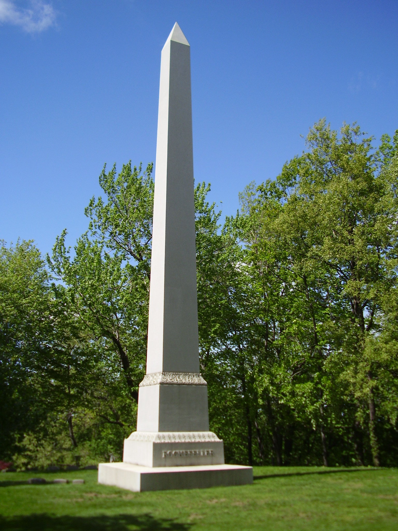
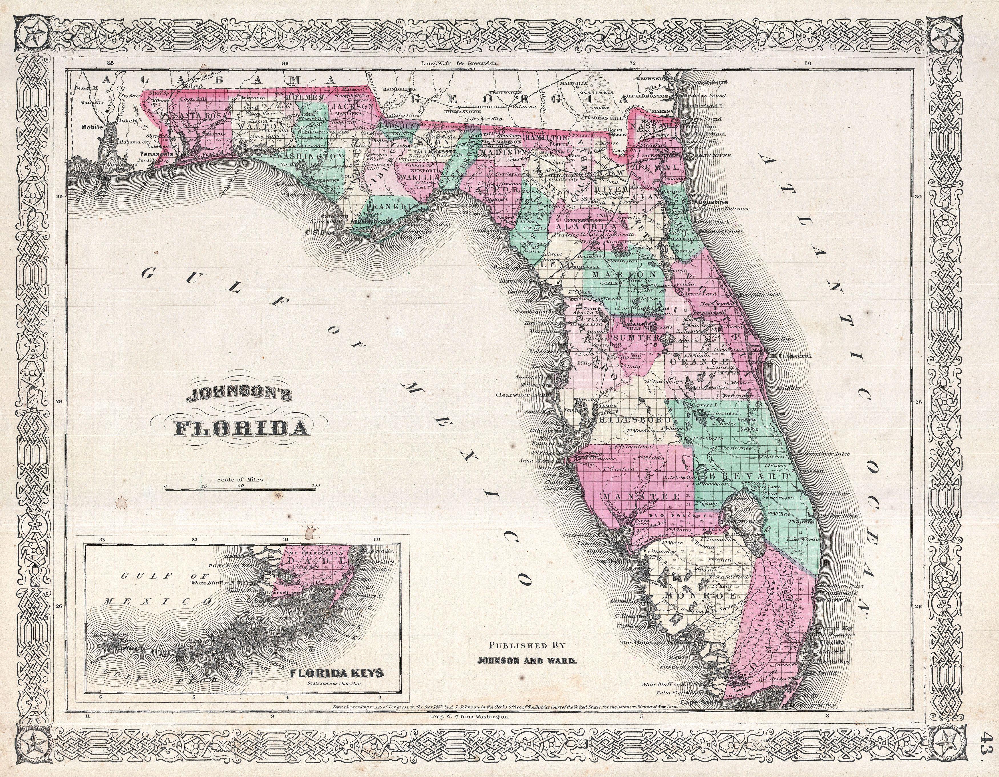
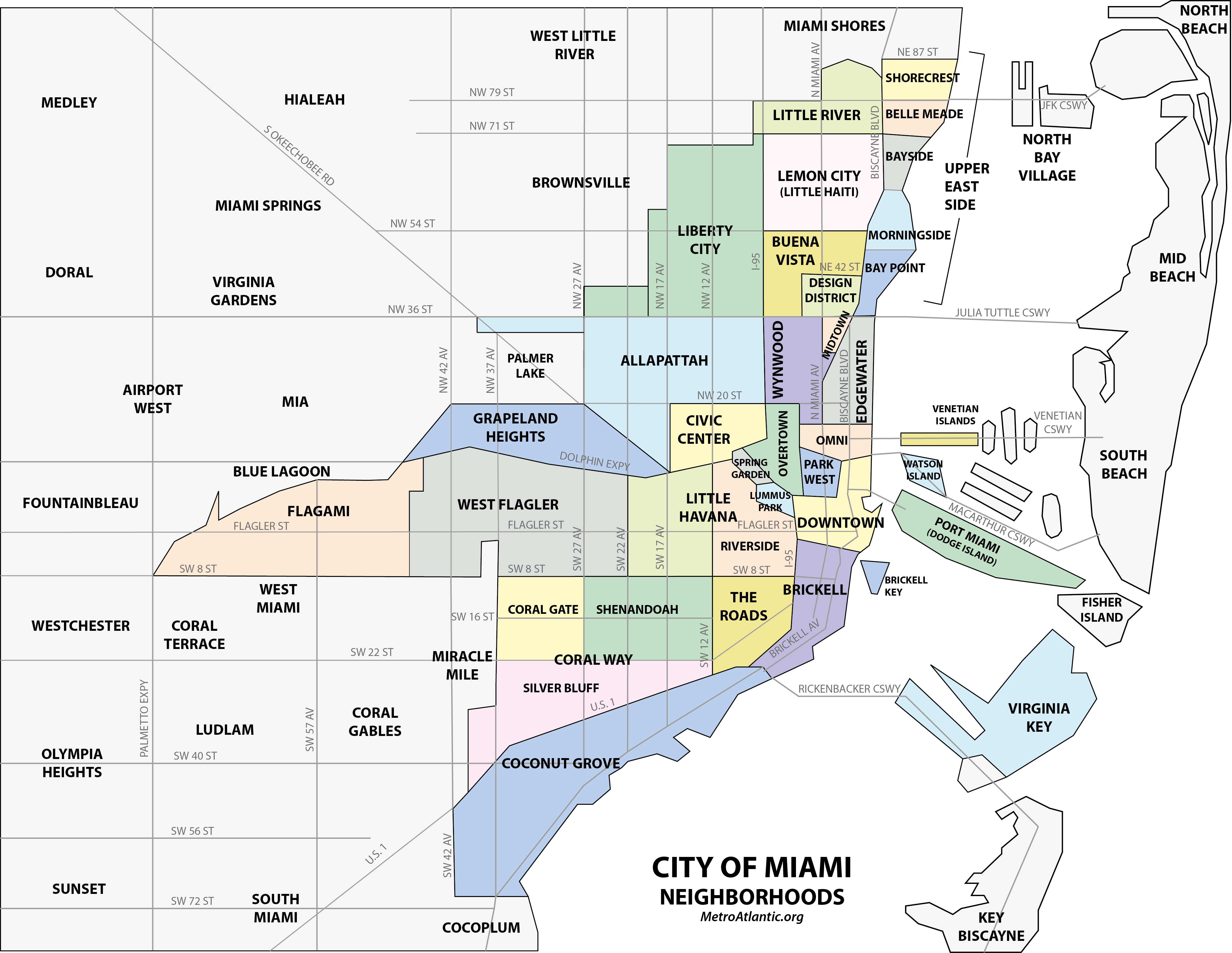