|
Reflections 2024
Series 7
August 1
SE Florida VII: Miami Beach's South Beach - Art Deco!
| | Miami Beach We are now well aware that Henry Flagler built resort hotels all along Florida's east coast out on barrier islands. But in Miami, because of the attractive deal Julia Tuttle set up for him (room for a rail station, a resort hotel, split the rest of her Miami property), he built his destination resort hotel on the mainland, the former Royal Palm in Downtown Miami. I cannot imagine that Flagler ever even set foot in the barrier island offshore from Miami that became the city of Miami Beach. | | | | | | Talking about Julia Tuttle: in recent years, the New York Times has done a series of articles called "Overlooked", which are obituaries about remarkable people whose deaths went unreported in The Times, the implication being that they are "Overlooked no More".
On 6 December 2021, I clipped the article where they memorialized Julia Tuttle as the "Mother of Miami". We already know her story, but on rereading the article, I enjoyed this bit of information: Flagler finally decided to visit the fastest way he could: He took a train to West Palm Beach and a boat to Fort Lauderdale, where he was picked up by Tuttle, who took him to her home in a wagon. How quaint! How times have changed.
|
| | | | And do realize that Miami Beach is a separate city from Miami, obviously based on Miami being founded on its own, early on. While I suspect few confuse Palm Beach on its barrier island with West Palm Beach on the mainland, I know that "Miami" is a word tossed around freely for the whole area, not helped by the fact the Dade County, which encompasses both cities, has renamed itself Miami-Dade County. When I was in Miami Beach on the current trip, I saw an advertising sign that started out "Here in Miami, we . . . ". So any confusion outsiders may have is compounded by locals.
Here's another curiosity. In Flagler's time, if someone said they're going to vacation in Miami, that was literal, since the elegant Royal Palm Hotel in Miami was pretty much the only show in town. But well into the 20C, the same statement would surely have instead referred to the ocean beach hotels of Miami Beach, even tho the person may have still said "Miami". I'm sure the only people who literally stay in Downtown Miami (or Brickell) are business people—and me, since, as a traveler and not a vacationer at that point, I wanted to experience Downtown Miami proper.
https://maps.lib.utexas.edu/maps/historical/miami_fl_1919.jpg
The oldest decent map of the area I found is this one, that we've used before, showing the area in 1919. It still shows Miami with the older street names, plus all the rail connections. While Government Cut existed already, this map fudges on showing it, as well as Fisher Island. But we know better.
As for Biscayne Bay, discount for the moment both the Collins Bridge to the Collins Canal area, and the motorboat racecourse—we'll get back to them in due course. In 1919, Miami has not yet grown too much, and neither has Miami Beach, which hardly reached the Collins Canal.
My guess is that Ocean Beach Street would be renamed 5th Street, the main road today fed by the MacArthur Causeway where I returned my car. I checked the online comments about this period map, and my guess was repeated by a commentator who said: My best guess, Ocean Beach Street is 5th Street, and Alton Beach Avenue is now 17th Street. If so, those two streets today pretty much define the Art Deco Historic District, with structures dating to the 1930s. But do note that even by this early date, some tourist facilities had been established, but WAY south below 5th Street. There are no other street names, but the heavy black line on the right seems to indicate Collins Avenue, with Ocean Drive to its right next to the ocean, and the heavy black line on the left would be Alton Road, the western extent of the Art Deco District. We can now build on this rudimentary information.
https://fcit.usf.edu/florida/maps/pages/3200/f3286/f3286.gif
This June 1921 period map is only two years later, but shows more details, including the rail line to the Royal Palm Hotel. But it does show the channel dug across the very shallow Biscayne Bay and into Government Cut in Miami Beach. The channel is marked as being 14 to 15.5 ft (4.3 to 4.7 m) deep. On the north side of the channel, the MacArthur causeway had just been completed in 1920 as an alternate to the deteriorating wooden Collins Bridge (more later). It was named the County Causeway until being renamed for General MacArthur in 1942. While some artificial islands are developing, there is no trace yet of Dodge Island to the south of the Cut, which would become PortMiami.
| | | | Ocean Beaches Just because Flagler apparently didn't show interest in the barrier islands off Miami doesn't mean that the early settlers in Miami seeking recreation were satisfied just splashing around in quiet, shallow Biscayne Bay or in the Miami River, as apparently early guests at the Royal Palm had done. From the beginning, ocean beaches were a lure, even if, lacking any fixed crossings of the bay, day-trippers had to take a ferry to the bay side and walk across to the ocean side, where there were bath houses and food stands, but no hotel.
But for those that wanted to go for more than just a day, the first hotel to open did so in 1915, the year the City of Miami Beach was incorporated. It was Brown's Hotel, which opened for the 1915-1916 winter season and is considered the very first hotel in Miami Beach, ever, anywhere. It's at 112 Ocean Drive, just north of 1st Street. You can't go much further south, or you'll fall into Government Cut, which had opened ten years earlier.
The hotel had 36 rooms in a two-story pine structure and offered the basics of the era with kitchen facilities on the ground floor. Over the years, the building was sold and renamed, and served as a hotel, also and apartments. Eventually, the original pine structure had been covered in stucco with some pieces blown off during Hurricane Andrew. But the building survived, and has been totally restored and returned to its original name. It's now the site of a popular, upscale steakhouse, with 9 hotel rooms upstairs, tho almost as an afterthought.
https://i.pinimg.com/originals/21/83/e4/2183e48a5b5cff41cd8e54d897da3052.png
This is Brown's Hotel in 1915, standing alone, seen from the side. How desolate it seems! I walked by here on my trip (see below). It's no longer standing alone, as the area is now built up, so it can only be seen from the front. Note the distinctive three-part roofline; I read online the comment that it looks like a Western trading post.
http://4.bp.blogspot.com/-ySrPjxxLat8/UR0FXQuYu_I/AAAAAAAADso/Ll3uWMOAH1Q/s1600/Miami+Beach+1921.jpg
Here's a period picture dated 1921 boasting ocean bathing in January. It's surely in the area of Brown's, but probably includes a lot of day-trippers. Do realize that it wasn't merely the style for men to wear bathing tops, it was usually the law. In this period and later, in many places in the US, men could be fined for going topless at the beach. O tempora! O mores!.
| | | | Agriculture Much of the interior land at that time was a tangled jungle of mangroves. Clearing it, deepening the channels and waterways, and eliminating native growth almost everywhere in favor of landfill for development, was expensive. What had been a jungle-matted sand bar added 75% to its size when dredging and filling operations were completed.
It's hard to picture Miami Beach being used for agricultural purposes, but that's what happened early on. A first step in the development of what was to become Miami Beach was the planting of a coconut plantation along the shore in the 1880s, but this was a failed venture. One of the investors in the project was agriculturist John S Collins, who achieved success by buying out other partners and planting different crops, notably avocados. There was effort to clear the land, plant crops, and supervise the construction of canals to get their avocado crop to market (see Collins Canal on the first map).
Although the farming venture was not successful, with involvement from his family, including his sons and sons-in law, Collins also became a land developer. He and his family formed the Miami Beach Improvement Company in 1911, instituted the first recorded use of the term "Miami Beach", and built the Collins Bridge in 1913. They built a casino (see map) and their own oceanfront hotel, and began residential development of the island. And, with help, Collins built the Collins Bridge, which opened in 1913.
At the time the Collins Bridge was completed, it was the longest wooden bridge in the world. It was built by Collins with financial assistance from automotive parts and racing pioneer Carl Fisher (see Fisher Island), who was interested because the bridge was located at the southern terminus Fisher's Dixie Highway project, which brought in traffic from the mid-west. Fisher loaned Collins $50,000 in 1911 ($1.6 million, adjusted for inflation) to complete the bridge when Collins' money ran out. Collins traded Fisher 200 acres (81 ha) of land on Miami Beach for the loan. Collins, his family, and Fisher all became very wealthy with the development of Miami Beach, which had a 400% increase in resident population between 1920 and 1925. Carl Fisher was the main promoter of Miami Beach's development in the 1920s as the site for wealthy industrialists from the north and Midwest to and build their winter homes there. He helped by organizing an annual speed boat regatta (see map) and promoted Miami Beach as an Atlantic City-style playground and winter retreat for the wealthy.
The 2.5-mile (4.0 km) wooden toll bridge, which kicked off Miami Beach's first real estate boom, opened in 1913 (perhaps the approaches made it 3 miles long). It provided a critical link to the newly established Miami Beach, formerly accessible only by a ferry service. The original wooden causeway was replaced in 1925 by a series of arch drawbridges and renamed the Venetian Causeway.
| | | | Area Overview Let's take a look at the entire area. The most informative map I could find is too bright red for my taste, but shows the best detail. It's also dated—from 1962—but we can work around that. For those who want to hold onto the map in a separate window, this is a link to the SAME map:
https://upload.wikimedia.org/wikipedia/commons/2/21/FL_Miami_347460_1962_24000.jpg
Start in the south end of Biscayne Bay (click). Dodge, Lummus, and Sams islands were created in 1903-1905 during the dredging of Government Cut, named after the US Government, which did the dredging. This map is dated 1962; during that decade, the three islands were connected via landfill to create the Port of Miami, the largest passenger port in the world.
Right above that, find our starting point where the city line runs east along the south side of MacArthur Causeway (1920), then runs down to include Fisher Island. Then go back to the starting point and follow it north to include Palm/Hibiscus, and Star Islands. Then, on the Venetian Causeway (ex-Collins Bridge) it separates two Venetian Islands in Miami from four in Miami Beach. There are also four Sunset Islands close to Miami Beach.
Moving further north, in 1961, the Julia Tuttle Causeway opened. It was years ago that I first heard the name of the causeway and wondered who Julia Tuttle was. I since learned a lot.
Further north still, we come to an anomaly, where the islands of North Bay Village form a political entity separate from either city, as the border lines show. NE 79th Street, which is close to the Amtrak Station "up in the boondocks" crosses north Bay Village. Here it's listed as the North Bay Causeway, but today it's called the John F Kennedy Causeway.
Look further north still to find where Miami Beach has a border with Surfside, a town notable for the infamous fatal condominium collapse in 2021. After 87th Street, Miami Beach ends at a small street called 87th Terrace, and between that and 88th Street was where the building collapsed, on the east side of Collins Avenue at #8777.
http://cdn6.bigcommerce.com/s-hry7g9g/product_images/uploaded_images/miami-map-.jpg?t=1430407461
I'm usually not in favor of touristy maps, but this one does illustrate the area quite well. I'll say again that Fisher Island had been part of the Miami Beach landmass, but was separated by Government Cut in 1905 and is not part of the City of Miami Beach. Since 2015, Fisher Island has the highest per capita income of any place in the US. As of the 2020 census, the population was 561. No road or causeway connects to the island, which is only accessible by private boat, helicopter, or ferry. Once a one-family island home of the Vanderbilts, and later several other millionaires, it was sold for development in the 1960s. When development began, it was for very limited and restrictive multi-family use. Celebrities living on Fisher Island include Julia Roberts, Oprah Winfrey, and Mel Brooks.
In South Beach, find 5th Street, delineating the South Pointe neighborhood from the Art Deco Historic District. In South Beach's Art Deco district, find Ocean Drive, and Washington Avenue--Collins Avenue, which runs the length of the city, is between the last two, but doesn't show here. On the right, in Mid-Beach, find and note the Fontainebleau and Eden Roc Hotels.
We've been talking about the divisions of Miami Beach, so let's find them now, via two maps. I like this map because it's simpler and easier to read (Map by Ypsilon from Finland). Here are the three divisions of Miami Beach: North Beach, Mid Beach, and the famous South Beach. Keep this view in mind, but note the errors: it shows both Fisher Island and North Bay Village as part of Miami Beach, which they are not.
Now this map (click) is a more precise graphic that names approximate borders (Map by bocablue). It also avoids the two errors of the previous map. Let's start at the top.
North Beach runs from Surfside (as above) at 87th Terrace (just beyond 87th Street) down to 63rd Street.
Mid-Beach runs from 63rd Street down to 23rd.
South Beach (SoBe) runs from 23rd Street / Dade Boulevard down to Government Cut.
However to my mind, it's further subdivided at 5th Street (as shown) to the older South of Fifth (SoFi) neighborhood, and the Art Deco Historic District north of 5th (actually, 6th).
| | | | South Beach History Just as Downtown Miami (spreading over to Brickell) is the historic hub of that city, South Beach is the hub of the city of Miami Beach. But then of course, everything is part of Miami-Dade County.
Just as Manhattan grew to the north from the oldest part, so did Miami Beach. We saw how in the beginning, Miamians came either as day-trippers or to stay at Brown's Hotel. This area grew, as did the area north of 5th. You can find Art Deco south of 5th (and in Mid Beach), but why did it hit the area north of 5th so strongly? That goes back to history we discussed in the past—see 2024/4.
After Miami Beach had experienced the Florida Land Boom (and Bust) in 1924-1926, followed by the destruction of the Great Miami Hurricane of 1926, and then the onset of the Great Depression, the city was ready for new construction, and thus the Art Deco movement reached Miami Beach. This is Miami Beach after the 1926 hurricane. It had to be rebuilt, and, when finances finally allowed, Art Deco was the international rage, reaching the US in the early 1930s. And Art Deco swallowed this area of South Beach (and more).
From 1935 to 1941, many of the famous Art Deco hotels along Ocean Drive were built before the onset of WWII ended construction. These included the Colony (1935), Savoy Plaza (1935), The Tides (1936), Surf Hotel (1936), Beacon (1936)--where I quite happily stayed—the Cavalier (1936), Leslie (1937), Park Central (1937), Barbizon (1937), Waldorf Towers (1937), Victor (1937), Clevelander (1938), Crescent (1938), Carlyle (1939)—where much of The Birdcage was filmed--Cardozo (1939), Winterhaven (1939), Bentley (1939), Breakwater (1939), Imperial (1939), Majestic (1940), Avalon (1941), Betsy Ross Hotel (1941)—now called the Betsy--St. Charles (1941), Clyde Hotel (1941). It's amazing how much hotel construction took place in this area in this relatively short period of time—and all Art Deco.
| | | | | | However, one other thing cannot be denied about those who lived south of 5th Street. Anti-Semitism was rampant in the 1920s and into the '30s. Developer Carl Fisher would not sell property to Jews, and many ended living south of 5th Street. One result of that is that Miami's first synagog (1929) is located there, which I visited. But it has Art Deco features! |
| | | | But neighborhoods go up and down, and in that regard, South Beach has a horrifying story to tell. The '30s and early '40s were its first Golden Age. Then a decline set in. Beginning in about the late '50s and continuing through the '80s, South Beach became unfashionable. Jet travel had enabled vacationers from the North to travel to the Caribbean and other warm-weather climates in the winter, and Miami Beach declined. South Beach became a retirement community with most of its ocean-front hotels and apartment buildings filled with elderly people living on small, fixed incomes. All of South Beach, north and south of 5th, was under urban blight, with vacant buildings and a high crime rate. As recently as the 1970s, South Beach was large deserted, aside from retirees. Art Deco buildings had mostly deteriorated. The primary commerce available was minimal and catered to retirees.
To make things worse, in 1980, the Mariel boatlift brought 125,000 Cuban immigrants and significant change to the Miami area. The mass influx of immigrants overwhelmed South Beach. The area did not have the infrastructure to house them and the city degenerated further into slum and blight. In order to help revive the area, city planners and developers sought to bulldoze many of the aging Art Deco buildings from the 1930s.
Then came South Beach's second Golden Age. In 1976, Barbara Baer Capitman and a group of fellow activists formed the Miami Design Preservation League (MDPL) to try to halt the destruction of the historic buildings in South Beach. The Historic District was declared, and preservation started. In 1981, the Miami Beach Community Development Corporation devised a plan to revamp the city, exploiting its tropical climate, beaches and a nearby available workers. And South Beach has since flourished.
| | | | | | In 1996, the two blocks of 10th Street between Washington Avenue and Ocean Drive was renamed Barbara Capitman Way. In 2016, during Art Deco Weekend, a memorial was dedicated featuring a bronze bust of Capitman. It's in the park across from the Cardozo Hotel at 13th and Ocean Drive. |
| | | | Art Deco So what's it all about? Characteristics of the Art Deco style originated in France in the mid-to-late 1910s, came to maturation during the Exposition Internationale des Arts Décoratifs et Industriels Modernes held in Paris in 1925, and developed into a major style in western Europe and the United States during the 1930s. Art Deco gets its name from the words in the lengthy title Arts Décoratifs.
It's a style of visual arts, architecture, and design that influenced buildings, furniture, jewelry, fashion, cars, movie theaters, trains, ocean liners, and everyday objects such as radios and vacuum cleaners. Here's an early example—it's a streamlined Art Deco train, the Pioneer Zephyr. On 26 May 1934, the Burlington's diesel-electric Zephyr made a record-breaking "Dawn to Dusk" run from Denver to Chicago for its grand entry as an exhibit for Chicago's Century of Progress International Exposition (see below). The Zephyr covered the distance in 13 hours, reaching a top speed of 112.5 mph (181.1 km/h) and running an average speed of 77.6 mph (124.9 km/h). The Burlington's event was covered live on radio and drew large, cheering crowds as the "silver streak" zipped by. Adding to the sensation of the Zephyr were the striking appearance of its fluted stainless steel bodywork and its raked, rounded, aerodynamic front end that symbolized its modernity. The train's design echoed in locomotive styling in the following years.
| | | | Art Deco New York As I was a teenager in the 1950s, whenever I entered Manhattan I was surrounded by Art Deco, which, frankly, at the time I felt was becoming a little dated, but by now, I'm a fan. All of Rockefeller Center is done in Art Deco. This is the Prometheus Fountain in the Lower Plaza there (the annual Christmas tree is put up right above and behind it). It's gilded bronze, dates from 1934, and has a dimension of 5.5 m (18 ft) (Photo by Balon Greyjoy). A block or so away, on Fifth Avenue, is the bronze Atlas statue, 1937, 14 m (45 ft) (Photo by Another Believer). The buildings of Rockefeller Center are Art Deco, including Radio City Music Hall--notice the verticality, the rounded edges; click to see the medallions on the side (Photo by ajay_suresh). And indoors, the curves and bright color of the proscenium scream Art Deco (Photo by Smart Destinations).
A little further south, the Chrysler Building has an ultimately distinctive Art Deco crown and spire--click to see the eagles on the 61st floor (Photo by Carol M Highsmith). In the lobby, this is an elevator door (Photo by Tony Hisgett). And a little further south still, the Empire State Building shows Art Deco styling (Photo by Acediscovery). Talk about verticality! Go up to where the brown stonework ends at the 86th floor observation deck and click for details of both the brown and white stonework. And on the tower above the "tower" look at the gray butterfly wings. The tower's tower ends at the rounded 102nd floor. All the antenna nonsense was added post-WWII and helps spoil the Art Deco look.
These are a pair of stylized, sculpted concrete eagles above its Fifth Avenue entrance (Photo by CS Imming). And behind that entrance, the lobby is stunning (Photo by 颐园居). Click at the top to see the building with its original rounded top before the ugly antenna was added, and notice the starburst effect. And check out the NYC area map at the bottom.
| | | | Characteristics We've seen examples of Art Deco. A sleeker variation called Streamline Moderne also emerged emphasizing aerodynamics even more, as well a smooth, polished surfaces. Let's try to generalize some characteristics of both, with streamlining emphasizing long horizontal lines. Streamlining went from railroad locomotives to toasters and appliances, buses, and any other device to give the impression of sleekness and modernity. In general for Art Deco, look for:
ROUNDED CORNERS: New technology allowed for construction with rounded corners. During the '30s and '40s the sleek design of ships, trains, and cars, where it reduced drag, influenced architecture, especially Streamline Moderne. Rounded corners made buildings appear aerodynamic, fast, and sleek.
RACING STRIPES: Also called bandings, these horizontal lines on building façades, usually in threes, either incised or applied with tiles, reinforce an aerodynamic look, a feeling of movement. Even more striking, they can be in a contrasting color.
EYEBROWS: The term eyebrow window could be a top window with a curved top in a wall or façade or a cantilevered window shade that looks like a shelf above the window.
GLASS BLOCKS: Cool, translucent squares of glass blocks used instead of brick allow for light penetration. They also can create a ziggurat "step" design.
GEOMETRY: Triangles, diamonds, zigzags, circles.
ANIMALS: Especially graceful or fast ones, like horses or gazelles.
Also: neon; symmetry; stylized nature; porthole windows; machine age symbols; etched glass; futuristic images.
Art Deco was one of the first truly international styles, but its dominance ended with the beginning of WWII and the rise of the strictly functional and unadorned styles of modern architecture.
| | | | Influence of World Fairs Art Deco designs are often described as evoking technological modernity, resilience, and optimism. The Miami Beach Art Deco Museum describes the 1930s Miami Beach building boom as coming mostly during Streamline Moderne period, a style that was "buttressed by the belief that times would get better, and was infused with the optimistic futurism extolled at America's World Fairs of the 1930s." From 1933 to 1940, these fairs promulgated visions of a brighter future during the worst economic crisis the US had known. While the Chicago and New York ones are best known, the six of them were:
Chicago: A Century of Progress International Exposition (1933–34)
San Diego: California Pacific International Exposition (1935–36)
Dallas: Texas Centennial Exposition (1936)
Cleveland: Great Lakes Exposition (1936–37)
San Francisco: Golden Gate International Exposition (1939–40)
New York: New York World’s Fair (1939–40)
Just some comments on the NY World's Fair: While all these fairs were meant to indicate a better future, New York's was the first exposition to be based on the future, with an opening slogan of "Dawn of a New Day", and it allowed all visitors to take a look at "the world of tomorrow". Its double symbol was famously the modernistic (and geometric) Trylon and Perisphere, paired here with a sleekly streamlined NY Central locomotive. They also appear on this very Art Deco US postage stamp.
| | | | | | I always wondered about those two names, and now find they were both made-up specifically for these structures. Trylon was specially coined from "tri[angular py]lon", and Perisphere was coined by adding, to "sphere", the Greek prefix peri-, meaning "all around, enclosing". |
| | | | Miami Beach Historic Districts Miami Beach has been blessed with quite a number of historic districts (HDs). We'll talk about three of them, illustrating how the city has grown from south to north, just as Manhattan has. Hold on to this map for a bit.
https://i.pinimg.com/originals/87/96/71/8796716cd80c5eccfbdec495c3ba1222.jpg
These are the South Beach HDs. I cannot explain the chaotic numbering system. Perhaps it's the order in which they were formed.
We'll start with the oldest part, which we've already discussed, Historic District 6: Ocean Beach with Brown's Hotel at #4. (Just south of this HD, note that Biscayne Street is now called South Pointe Drive.) As a rule of thumb, we know that this is often referred to as "South of Fifth", 5th Street being that major entry point from MacArthur Causeway.
Much more spectacular is Historic District 2: Ocean Drive/Collins Avenue. This is a major hub of the Art Deco area. Much was built up after the various disasters of the 1920s in the newly popular international Art Deco style.
| | | | | | In 1979, Miami Beach's Art Deco Historic District (Michelin 3*) was listed on the National Register of Historic Places. It's the largest collection of Art Deco architecture in the world and comprises hundreds of hotels, apartments and other structures erected between 1923 and 1943. Mediterranean, Streamline Moderne and Art Deco are all represented in the District. The Historic District runs from the ocean west to Lenox Court, a half-block beyond Lenox Avenue. It starts at 6th Street and runs north to roughly 23rd Street at the Collins Canal.
The movement to preserve the Art Deco District's architectural heritage was led by former interior designer Barbara Baer Capitman. In 1996, two blocks of 10th Street in South Beach, from Ocean Drive to Collins Avenue to Washington Avenue, were renamed Barbara Capitman Way.
|
| | | | Miami Beach continued to grow to the north, and by mid-20C, an area of much taller resort hotels appeared in Mid-Beach. This more extensive map shows HDs the full length of the city, and they are color-coded. The two above ones (click) are in gold and light blue. The third HD we'll be discussing later is the very next one up the coast, in olive green, the Collins Waterfront Architectural District. We'll also mention in passing the next teal one, the Morris Lapidus Mid-20C HD. | | | | Past Visits Visits As I review the past, it seems I made three visits to Miami Beach before the current one in November 2019. One is a mystery, one was a day trip, and one was for a single night. Sounds like a jumble, right?
I've often referred to the set of 20 small travel diaries Beverly and I have used over the years to document travel. I've always considered them complete, but recently discovered a double gaps. Keeping a travel diary was all Beverly's idea. When we met at the six-week Middlebury German Summer School, then went for our Middlebury Master's degrees for the year in Mainz, she kept a diary, now labeled 1961-1962. We then got married, and she continued teaching (she'd taught for two years in Minnesota). I spent 1962-3 translating for American Express on Lower Broadway near Wall Street. In 1963-4 I attended Columbia University, first in the German department, then, once I saw how interesting Beverly's teaching life was, in the second semester I changed over to Columbia's Teachers College on 120th Street and took education courses to get my teaching credentials for my New York State teaching license. I started teaching in September 1964.
I now find that the second travel diary in the set is dated 1965, covering a lengthy trip that summer to Spain and the Middle East (notably Egypt), and the series continues to this day. But what happened to 1963 and 1964? These are a pair of "blank" years.
Furthermore, I always thought I got my first car right after we got married, but on second thought, that's not so. We were carless for those two years. I now believe it was when I started teaching that my father helped me buy a used red Nash Rambler. Presumably we did not travel in the two impecunious newlywed "blank" years, hence no diaries. But we actually did—there were two trips. But which was which year?
I'll work backwards. There was one occasion where Beverly's uncle Phil, for some complex reason, drove east from Minnesota and stopped to visit us in the North Bronx. He'd arranged to leave his car with us and we would then drive it back to Minnesota for what must have been Beverly's first trip back home after getting married. I remember that was the time we avoided going around Lake Michigan via Chicago, and instead took the ferry across the lake to Milwaukee. There we stopped for a night to visit her uncle Dave and his family, including his young daughter Carole. In 2022, when I returned to Milwaukee, I got together with Carole and her husband for a pleasant day. What goes around comes around.
In any case, I also remember that, after we left home, we stopped at Columbia en route for me to take a final exam at Teachers College (!), then drove west. Also, I remember hearing on the car radio on that trip that a new Mary Poppins film was coming out, and I've checked to confirm that that happened in 1964. So the Midwest Trip was the blank in 1964, probably in the summer.
1) THE FLORIDA DRIVE-AWAY MYSTERY TRIP That leaves 1963, probably Easter week, to be the year of the Florida Drive-Away Mystery Trip, culminating in South Beach. But why "mystery"? And how can it be a drive-away trip if we had no car and certainly couldn't afford to rent one for that distance? The plot thickens. One thing at a time.
To manage to afford our first pleasure trip as newlyweds, we did something unique for us. We'd never done it before, and never did it again. We signed up with a driving service to drive someone's car to Florida. They'd gone to Florida and wanted their car there, but didn't want to drive it all the way. There are, I'm sure, websites today for drive-away services for cars, particularly between the Northeast and Florida, but we did it based on an ad in the NY Times.
I remember calling the agent, the rudest man I'd ever spoken to on the phone. He had NO phone manners. He'd answer your question, then would immediately hang up. If you had another question, you had to call him back. Terrible. I checked with him if there was any rush—he said we could take our time driving down.
As I piece the memory together, we took the subway into Manhattan, then to Queens somewhere (Long Island City?), where the (rather large) car was in a parking garage. We got the keys from the attendant (so informal!), then drove off.
We probably reached North Carolina the first night, then crossed into Florida on the second day. We were such tourists! Florida had—and I understand still does have—welcome centers right across the border from Georgia. There was a complimentary glass of orange juice (so corny!) and free brochures. In those years we depended a lot on those brochures. We continued down the east coast, relishing every town's name. Then we drove inland and got a motel outside Disney World. (!) With all Florida has to offer, why were we so obsessed with going THERE? On the third day we visited the complex, then in the late afternoon, drove back to the coast and followed the barrier island route to Miami Beach. I emphasize that since it's an unusual way to arrive.
That would mean we must have gone the full length of the city, including mid-Beach, not realizing just what its various parts were. But it was obvious when we arrived in South Beach, because by 1963, it was in severe decline. I know we drove around Collins Avenue and Ocean Drive, and saw that every surface needed a coat of paint—if not five. I remember windows and some doorways boarded up with plywood. There were few people around, mostly elderly retirees, with local businesses catering to their needs. It was a sad time for what had been so spectacularly glorious back in its own day. (It's back now!).
I don't remember where the older couple's address was where we delivered the car. It might have been in what is now the Art Deco district, but was more likely South of Fifth—I just don't know. I remember parking in front of a low apartment house, taking our bag from the car, and going up to deliver the keys. When the couple answered the door, I remember the man saying "Well! It's about time!", so it was not a pleasant experience. I did explain the agent told us we didn't need to rush, but diplomatically kept mum about going to Disney World.
That's the end of the story, so it's why I call it the mystery trip. While I remember the southbound trip in detail, I remember nothing else. Did we get paid for the drive-away service? I don't know—maybe getting a "free" trip to Florida was the pay, maybe not. It was about the only time I did work for which I might have been eligible for a gratuity. Did we get one? I don't know. If so, it wasn't much, but probably not. Where did we spend the night? How did we get there without a car? Did we stay the full holiday week? Possibly. How would we have afforded it? How did we get home? Probably by Amtrak coach class, but I just don't know. That's why my first visit to Miami Beach—and to Florida--is a drive-away Mystery Trip.
I have someone else's comment about South Beach in the '60s. I met friend Bruce Tuffli from the Saint Louis area, with others, on the trip out of PortMiami (!) to the Amazon in 2011. We were corresponding a few years ago about Miami Beach, and were surprised to both have been there a year apart, during the "bad years". On 21 April 2020, Bruce wrote (mildly edited):
I was fortunate enough to spend the summer of 1964 there [in Coconut Grove at a friend's house] while attending summer school at the University of Miami [and we drove around a lot] . . . The (now posh) South Beach area was a bunch of old hotels which had become a retirement community with the elderly sitting out on the front porches in rocking chairs facing the beach on Ocean Drive. In the years after that it eventually deteriorated to become an area of dilapidated, deserted buildings serving as drug houses. The area was often featured in the popular Miami Vice TV series In the early 80s. Thankfully that whole area was beautifully renovated starting in the 1990s. The more well-known Collins Avenue to the north was the location of the elegant Fontainebleau, Eden Roc, Deauville and Carillon hotels in the 60s, 70s and 80s. I haven’t been back to the Beach in over 30 years, and I’ve heard that all these hotels are gone.
Having checked a bit more, I find those hotels in mid-Beach are more likely remodeled than gone. A further recent note from Bruce explained that he was completing undergraduate requirements, since he was lacking two required courses for his Bachelor of Fine Arts degree from art school at Washington University in Saint Louis and found he could take them at the University of Miami's summer school, staying at the friend's house. Obviously an easy decision. I still fondly remember going to classes in the mornings and going to the beach in the afternoons.
Thus we have two eye-witness accounts, a year apart, of the South Beach Art Deco area during its decline.
2) THE VERSACE & AGGRESSIVE TOUT DAY TRIP You may recall that Gianni Versace was assassinated in front of his Miami Beach house in 1997. The next year, 1998, we were in Miami, probably visiting Beverly's brother and his family south of Miami, when we decided to view the scene. I do remember walking past his house, the Casa Casuariana, on Ocean Drive at 11th Street. But then, walking down Ocean Drive back to our car past the revived Art Deco buildings, we had a very negative experience. The sidewalk in front of these buildings is narrow, made more so by café tables. A tout, put politely, is someone who solicits patronage, often aggressively. At the time, every hotel, bar, and restaurant had a tout (or several) out front accosting passersby to enter the premises, like at a carnival midway. Thus we found ourselves doing a "tout-walk". The worst was when one young man stepped in front of me and literally blocked me from proceeding. As I pushed past him without comment, he turned and asked if I thought I was too good for him. Of course I thought that, but still kept quiet. I'm very happy to report that this miserable situation no longer exists, discussed further below.
3) MID-BEACH OVERNIGHT AT THE VERSAILLES For reasons I now do not recall, in 1984, we took Amtrak to Miami Beach for just one night, 19 February. I suppose we'd been hearing a lot about the high-rise hotels in the Mid-Beach area, and we decided for some reason to stay at the Versailles, at 3425 Collins Avenue at 35th Street. I remember we took a city bus from near the Amtrak station, most likely bus 79 along 79th Street, across the North Bay Causeway, then turning south on Collins down to 35th.
I do remember enjoying the short stay and taking a long walk down Collins to the Art Deco district. However, I remember nothing of the rest that the travel diary says we did: that we walked back north on the boardwalk; swam in the Versailles pool and walked down to the nearby surf at the hotel; and after dinner walked 15 minutes further north to the Fontainebleau Hilton and the Eden Roc. Both those iconic hotels had been built in 1954, but I do not remember seeing them. The next day we took the city bus back to the train, and rode it back up to Kissimmee for a longer visit to Disney World. What was our obsession with Disney?
I've now been able to review the story of the Versailles and understand it better than I did at the time. The original building, as seen in this postcard view c1945 of the Versailles and its beach, opened in January 1941 for seasonal occupancy from December to April. (!) It occupied the entire oceanfront block on Collins from 34th to 35th Streets and consisted of a 16-story (including the copper-domed open cupola) Art-Deco-style tower at the northwest corner of the property (at 35th Street).
https://www.floridamemory.com/fpc/postcard/PC16117.jpg
However, in 1955, an eight-story addition was built in Postwar Miami Modernist style. This is how we apparently knew the building.
| | | | | | Miami Modernist architecture, or MiMo, is a regional style of architecture that developed in South Florida during the post-war period. It can be seen in most of the larger resorts, particularly in Mid-Beach and North Beach along Collins Avenue. Principal examples of MiMo include the Fontainebleau, Eden Roc, and Deauville hotels by famed architect Morris Lapidus. |
| | | | An implosion occurred here in 2016. At first I thought the whole Versailles was gone, but look closely at the implosion on YouTube (0:15) and you'll see that the new developers only imploded the newer 1955 addition. I don't know which section we stayed in, but it's possible I've now spent a night in a (part of a) building that's been imploded!
https://images.squarespace-cdn.com/content/57916842bebafb827652722c/1610562611030-JXHAE8EGMHJYXV5G7O6S/Aman+Miami+Wins+Approval+For+Versailles+Hotel+Restoration+In+Miami+Beach%E2%80%99s+Faena+District?content-type=image%2Fjpeg
But again, what goes around, comes around. The new developer has refurbished the original 1941 building of the Versailles into 56 hotel rooms (plus 23 residences in the new separate building on the right). The Versailles is a contributing building to the Collins Waterfront Architectural District, designated in 2000.
This next map is the same as the one we saw before, except that this version enlarges hugely. Go to the middle of the olive green HD. The Versailles is at Collins and 35th, Now move up to the Morris Lapidus Mid-20C HD. His iconic hotels are just over the border. The Fontainebleau is at 44th and Collins, and the Eden Roc at 45th.
| | | | | | As a point of information, I'll mention this. I've pointed out the free shuttles in Baltimore and Manhattan that I've used, and the one in Key West that I haven't. We'll be talking shortly about the ones in South Beach I used extensively, so for the sake of completion, let me mention the free Middle Beach Loop.
https://www.miamibeachfl.gov/wp-content/uploads/2019/01/4.Middle-Beach-map-WEB-01.jpg
Not only didn't I use it, I doubt it even existed four decades ago when I was in Mid-Beach. But for use today, it does cover the area of the hotels we've mentioned.
|
| | | | Visiting South Beach in 2019 We now get back to the "present" trip, which, for the purposes of this posting, is November 2019.
https://storage.googleapis.com/raremaps/img/xlarge/60321.jpg
I don't usually care for this type of touristy map, but this one orients one well to the area. It shrinks South of Fifth (click), tho it even shows Brown's hotel (unnamed). But find Ocean Drive facing the park, with Collins Avenue behind it, and you'll see the most eminent stretch of iconic Art Deco hotels, including the Beacon Hotel, where I stayed on this trip. The map even shrinks Mid-Beach into view, including the Fontainebleau Hilton and Eden Roc, tho alas, no Versailles.
We'll also present this real-life view of Ocean Drive featuring the Betsy, once the Betsy Ross (Photo by chensiyuan). It illustrates the low-rise style of the 1930s as opposed to the high-rise hotels in Mid-Beach later on. Ocean Drive runs from 1st to 15th Street, but its Art Deco area starts at 6th. (The Betsy is north of 14th.) Here's another, fuller view down Ocean Drive looking south, with Lummus Park on the beach side (Photo by User:Cacophony). Ocean Drive is responsible for the South Beach esthetic that most visitors expect.
| | | | Day 9: Sat Nov 9 (Second Half): South Beach I This was the day that I left Key West, passed the laundrette, had the water scare on the road, crossed downtown Miami on the elevated road, drove over MacArthur Causeway to 5th Street and returned the car. After checking out a few potential restaurant choices on Washington and Collins, I directed myself to Ocean Drive, intent on seeing if I could find any aggressive touts, and hoping I wouldn't. I stopped outside the very first hotel restaurant I saw. I feigned interest on the posted menu, but the woman with menus under her arm kept her distance and didn't accost me in the slightest. As I walked along, neither did any other tout. Apparently, some strict regulations had been passed. Happy days! | | | | Beacon Hotel The Beacon Hotel dates from 1937, making it two years older than I am. It's at 720 Ocean Drive, which tells you it's just north of 7th Street—a nice numbering system.
https://s3.amazonaws.com/gs-waymarking-images/cf2ef5b9-1a88-4027-b371-9dc1e9089510.JPG
Since I stayed here, I knew it best, and will use it to illustrate the typical Art Deco hotel on Ocean Drive. Click to check out its Art Deco details. Here is an expert description from online:
| | | | | | In Art Deco tradition, this hotel has a tripartite facade with a vertical emphasis, with horizontal details countering the upward movement. The central bay is thrust forward in small steps and even the top rises in stair steps. The boundary between the central and side bays is filled with abstract patterns – skewed diamonds and circles. The top has semicircles and angular patterns. The countering horizontal movement is in the relief stripes . . . |
| | | | I knew I'd lucked out with this decision long before I arrived. When I reserved the room on booking.com, I promptly got an unusual message telling me I'd gotten the best room in the house. If I was at all skeptical about that, after I registered, Veronica, the Concierge, told me exactly the same thing!
Click on the top floor, the fifth. My room was that corner room in the center of the picture. It had both an east view to the park and beach across the street, and a south view toward huge ships exiting Biscayne Bay via Government Cut. The two narrow windows to the right are in the hall at the elevator, leaving one more top-floor front room. Maybe that was the second best.
| | | | | | One of the two very minor inconveniences was the elevator, which was the only one—there was no service elevator, perhaps typical of the 1930s. However, the staff was very solicitous about standing aside with their laundry carts if a client was about to use the elevator. It was nothing, really. |
| | | | We're talking about the view, so the below typifies what one sees of the Atlantic from the fifth floor looking east:
https://d3r0vp1728f7ny.cloudfront.net/beaconsouthbeach.com-973616499/cms/cache/v2/595ea1b48516e.jpg/1680x942/fit/80/451e639aa244d1ca45c4ad6586b06076.jpg
Note the iconic lifeguard stand. The room also offered beach towels and a folding beach chair to take across the street, but the day I went over to the beach, I simplified things—explained later.
https://i.onthebeach.co.uk/v1/hotel_images/75e1c087-79db-4ee3-a13e-55702f10c1cd/cover/1000/600/high/1.0/beacon-hotel.jpeg
At night, Art Deco hotels like to show off with light and color.
https://images.fineartamerica.com/images/artworkimages/mediumlarge/2/beacon-hotel-in-south-beach-claudia-uripos.jpg
In front of the hotels, the sidewalk cafés take up much of the width of the sidewalk all along this west side of Ocean Drive. Also, most hotels have a raised stone porch area on either side of a small entry stoop. Presumably in the pre-air conditioning era of the 1930s, the porch provided hotel guests with sea breezes and ocean views. The restaurant now uses the porch (and sidewalk café) for serving, and the left (south) side serves as its breakfast buffet area. But during breakfast, the sea breezes are still there, tho the trees in the park across the street now limit sea views from the main floor.
https://media-cdn.tripadvisor.com/media/photo-s/12/63/40/43/the-place-is-located.jpg
This view shows that the restaurant still has its tout (a person soliciting business) carrying menus next to the posted menu. Perhaps nowadays tout is too harsh a word, since she's just trying to promote business by answering questions, not badger anyone, which is what the word usually implies.
The other minor inconvenience was because the restaurant, The Place, is apparently a separate business entity from the Beacon Hotel. While they did serve the hotel's complimentary buffet breakfast, they did set their own hours, serving breakfast at a latish 9-11. I found that quite pleasing, since I'm not an early bird, and this was one hotel breakfast site that reflected my tastes. But on the last day, I needed to get a particularly early start to get my train, and had to skip the breakfast because of the late hour it's served.
It was a bit noisy on Ocean Drive, as I hadn't realized it was Saturday night; then there'd be Sunday tourists, and Monday was a holiday, Veterans' Day. But it all worked out well.
https://assets.simpleviewinc.com/simpleview/image/upload/c_fit,w_1440,h_900/crm/miamifl/Beacon-Hotel-South-Beach6-1440x9000-ed8022365056a36_ed802476-5056-a36a-0bd7e69d292b67d4.jpg
The interior lobby of the Beacon is strikingly and thoroughly Art Deco. Just look at the windows in those entry doors and the railing on the mezzanine! To the right is the entrance to the breakfast area at the porch.
https://assets.simpleviewinc.com/simpleview/image/upload/c_fit,w_1440,h_900/crm/miamifl/Beacon-Hotel-South-Beach1-1440x9000-ed62cd2d5056a36_ed62ce67-5056-a36a-0b777c752efa7ddd.jpg
This is the reverse view, looking up at the mezzanine from the entry. And do I remember those ultra-high-backed chairs! Actually, these hotels are quite petite, especially when compared to the later Mid-Beach high rises. The entire center part of the hotel is not much wider than what you see.
I settled in quickly that first evening and wanted to get back to those restaurants I'd checked out when I returned the car. But that overcast from when I'd had that water scare in the afternoon was developing quickly into something more serious. Still I persevered, because I felt that restaurants right on Ocean Drive might be overpriced tourist traps. Taking my umbrella into what was now a cloudburst, I got about a block south when I found that my shoes were soaked, as were my pants up to the knees. So I returned, changed clothes, and decided to try dining at The Place. They had large plastic curtains in the porch against the rain. The food was not great, but decent, yet they did not have the super Italian touch with the food and drink that they should have. So I spent more of that first night than expected right at the Beacon Hotel on Ocean Drive.
| | | | Day 10: Sun, Nov 10: South Beach II Today the weather was beautiful after last night's storm and I decided to do the obvious—check out the row of Art Deco hotels on the rest of Ocean Drive, starting at 7th Street, just south of the Beacon, then selecting hotels while moving north.
On the south side of 7th, at the end of the 600 block at #660 is the Majestic Hotel, 1940 (Photo by Elisa.rolle). Note the verticality, the colors, and the three's.
Across 7th and on its north side, this is the 1941 Avalon Hotel, just south of the Beacon, which is seen on its right (Photo by Elisa.rolle). It's bicolor, and its iconic corner tower is better seen from this angle:
https://1.bp.blogspot.com/-YTErG4Ht57A/UQr27rxtTvI/AAAAAAAAhbQ/tvj3NT6_1RU/s1600/700+Ocean+Drive+(3).JPG
Note the three strips under the flagpole to complement its three floors. At night, the Avalon joins the Beacon and others in the color parade:
https://assets.simpleviewinc.com/simpleview/image/upload/c_limit,w_1600/crm/miamifl/Avalon-1-Street-added_F9D608FF-C61F-4583-A4E8B9940C9A32E1_f5a9c3d7-9a61-4f0e-ac9a3eab7e27269d.jpg
Here's a fuller view at night of just the Beacon and Colony, both in blue, the Colony with its iconic neon sign (Photo by User:Ld). Beyond the (out-of-place) CVS drugstore, the next blue light is indeed the Colony. Here's a direct view of the 1935 Colony Hotel in Streamline Moderne style, at #736. It's the oldest Art Deco hotel in Miami Beach and was the first hotel locally, and perhaps in the US, to incorporate its neon-wonder sign as part of its overall design (Photo by Elisa.rolle). Look again to see what neon does to the Colony's sign (Photo by Discoizzy).
| | | | | | At 760, at the corner of 8th Street, is a chain bar called Wet Willie's. What impressed me here were the posted instructions given to patrons, which seemed to reflect the cracking down on unruly behavior. Patrons were told not to leave the taped-off bar property carrying alcohol, and after 8 PM, no sunglasses were allowed for men or women, as well as no hats for men or women. Pretty strict—and it apparently helps. |
| | | | Jumping up a block to 940 Ocean Drive, mid-block before 10th Street, we find the Breakwater Hotel, 1939, whose sign and horizontal stripes stand out (Photo by Gzzz). At 960 is the Edison, 1935, on the south side of 10th Street, this section of which is also called Barbara Capitman Way. At this point, across Ocean Drive and in the park is the Barbara Capitman Monument (Last Two Photos by Daniel Di Palma).
When we cross 11th we come to something different in age, style, and history. The first house, at 1116, is the Casa Casuarina, also known as the Versace Mansion (Photo by Daniel Di Palma). It's older than most structures on the street and of a different style, built in 1930 in Mediterranean Revival style for an heir to Standard Oil.
The casuarina is a genus of flowering plants also known as the Australian pine, native to Australia and southern Asia. It's considered an invasive species in the US, the Americas, and Africa. One theory that seems appropriate is that the Casa Casuarina might have been named after a tree on the lot that survived the 1926 Miami hurricane.
Its alternate name is based on the fact that it was owned by the Italian fashion designer Gianni Versace. He lived there from 1992 until his death in 1997, when he was murdered on the front steps of the villa by a serial killer who murdered five people over the three months in 1997, from April 27 to July 15 (Versace). The killer committed suicide eight days later, with a pistol used in three of the murders, including Versace's.
Since 2015, the mansion has been adapted into, and operates as, a luxury boutique hotel known as The Villa Casa Casuarina.
Further along, mid-block, approaching 13th, we reach #1244, the brightly colored Leslie, 1937. And literally next door, at #1250, and on the south side of 13th, is the Carlyle, 1941 (Both Photos by Daniel Di Palma).
The Carlyle was a hotel, and is now condos, which I find an interesting move. But the Carlyle has another distinction that none of its Art Deco sisters on Ocean Drive have: the Carlyle played a part in a well-known movie!
I have an entire future posting waiting in the wings about the evolution of La Cage aux Folles, whose American filmed version in 1996 was cleverly renamed The Birdcage (name explanation to follow in the future). First, watch the iconic opening shot (2:22)--computer-assisted, surely--on YouTube to The Birdcage.
Pause it at 1:07. Straight ahead is the Carlyle--in drag! It's wearing a green-and-yellow costume. It also presents two of its neighbors with it. To its left is the Leslie in orange drag, and to its right, across 13th Street, is the Cardozo that we'll meet shortly, in purple and blue.
http://i.ytimg.com/vi/qlDo1mgqTRQ/hqdefault.jpg
http://travellatte.net/wp-content/uploads/2015/07/Miami-Beach-Art-Deco-The-Carlyle-as-The-Bird-Cage.jpg
This first link is of just the Carlyle "playing" the Birdcage Club—just the exterior--while the second link compares the two views. How did they change it? Sticking to the second link, we see that the three vertical elements were colored yellow. The three horizontal elements were made green. The two plaques at the top were made purple. The sign was altered, tho close inspection will show that the script "The" remained the same! They added the purple sign that says "Starina". The porch area kept its four columns, but it was altered to imply there was nightclub activity going on there. Very clever.
| | | | | | I refer back to 2024/5, where we showed a picture from The Birdcage of Robin Williams and Nathan Lane sitting on a bench that I believe was located on or near MacArthur Causeway. The Carlyle ties together with that shot. |
| | | | As we cross 13th Street we come again to the Cardozo, 1939, at #1300 (Photo by P Hughes). Its very rounded corners and racing stripes show that it's Streamline Moderne.
We have one more hotel right on Ocean Drive, it's the striking, very green Ocean Plaza north of 14th at #1430 (Photo by Daniel Di Palma).
Again, the Art Deco HD on Ocean Drive starts at 6th, and Ocean Drive ends at 15th, tho the HD goes beyond it to the north (and west). This iconic street was my basis for choosing a hotel in that stretch, and for choosing Art Deco illustrations there. All the above online pictures, from the Majestic on the south side of 7th, to the Ocean Plaza north of 14th, were directly on Ocean Drive. This is by no means a definitive showing of buildings, either on Ocean Drive or further inland. But I did like two more on Collins.
If we turn inland on 12th one block we come to the Marlin, 1939, on the northwest corner of Collins and 12th, at 1200 Collins Avenue (Photo by StefenettiE). How round! How vertical! And walking two blocks south, we come to the Essex House, 1938, on the northeast corner of Collins and 10th at 1001 Collins Avenue (Photo by Infrogmation). Click to inspect the racing stripes, the rounded corner, the circle designs, and the triumphant tower, repeating the name. And when we go around the side onto 10th Street, we see the rounded corner theme is repeated once more (Photo by Photogphillip).
It's an easy walk to take in so many of these buildings, and great fun to actually live a few days in one of them. But there are other things to see. I've talked about the free shuttle buses in several cities, including the one in Mid-Beach, but important to me were the free shuttles in South Beach.
https://www.miamibeachfl.gov/wp-content/uploads/2019/01/2.-South-Beach-Trolley-service-map-WEB-01.jpg
Disregard the one in the center that's a variation. Basic are Loop A that runs clockwise and Loop B running counterclockwise. You'll see that the part of the route closest to Ocean Drive and Collins runs conveniently along Washington Avenue, from where I used the shuttle several times in both directions. On this day I took Loop A south (clockwise) to South Pointe Drive (still listed as Biscayne Street on the Art Deco map) to finally got to visit South Pointe Park. I'll say again that on the Regatta leaving Port Miami on the trip to the Amazon River in 2011 (see 2011/12) I remember waving to people on shore as we sailed, and since learned they were in South Pointe Park as we traversed Government Cut. I enjoyed visiting the park, tho while I was there, no ships sailed thru Government Cut for me to wave to. It was still fun to be there—what goes around comes around.
| | | | | | We talked about Government Cut before, but now it's appropriate to discuss it again as I viewed it from the park. The short waterway cut thru the barrier beach and was authorized by the US government. The first time I heard the name I thought it was far too utilitarian, but now find it quaint and charming.
Before the Cut was established, a single peninsula of dry land stretched from what is now Miami Beach to what is now Fisher Island, and boats destined for the port at the mouth of the Miami River had to pass around Cape Florida at the southern end of Key Biscayne, and had to arrive in port from the south. Miami developed further as a port when the Government Cut shipping channel was created in 1905, cutting off Fisher Island from the south end of the Miami Beach peninsula and allowing better access to the Port of Miami directly from the east.
https://www.versluis.com/wp-content/uploads/2014/03/key-biscayne-map.jpg
https://farm4.staticflickr.com/3570/3464018057_68bac53b0e_b.jpg
https://c1.staticflickr.com/5/4093/4869588921_19b27f099a.jpg
https://farm5.staticflickr.com/4047/4374610942_7478097df7_z.jpg?zz=1
https://images.squarespace-cdn.com/content/v1/56b8b91a3c44d84c96aae4e4/1455047197173-06HA6UHU42Q2DUP98OI6/ke17ZwdGBToddI8pDm48kDkt_mEUwPAwWp3BKCAozPR7gQa3H78H3Y0txjaiv_0fDoOvxcdMmMKkDsyUqMSsMWxHk725yiiHCCLfrh8O1z5QHyNOqBUUEtDDsRWrJLTm1v6GcKqh6mrhfxzW2tqo79JMOdxdw3gZxKvUtNIhuIodLUO5vPPWIex2d798oGnj/SOUTH+POINTE+24.jpg
The first link is a map showing the area. Dodge Island is the Port of Miami; US 41 (actually SR 599) is MacArthur Causeway and Government Cut (not named) leads east from there providing. Cape Florida is at the bottom of Key Biscayne, and ships arriving from the south also had shallow waters to contend with.
The second link shows cruise ships docked at Dodge Island with the MacArthur Causeway on the left. We are looking east out to sea—the Atlantic--via Government Cut, with Miami Beach and Fisher Island in the distance.
The third link is exactly the reverse view. Fisher Island is on the left and South Pointe Park on the right, and we're looking west to the port and Miami.
The fourth link shows South Pointe Park as it blends in with the beach area of South Beach. You can see where Ocean Drive (right) and Washington Avenue (left) end at the park, while Collins Avenue is cut short and ends in that shadow area. The bulk of the picture just shows the South of Fifth neighborhood.
|
| | | | My next step was to get back on the shuttle in same clockwise direction so I could complete an entire loop, which results in a great free tour of the whole area. This included (see route map) looping thru Belle Isle, the easternmost artificial island on the Venetian Causeway (ex-Collins Bridge). It's the only time I've ever been on any part of the Venetian Causeway. We then looped thru the northernmost part of the Art Deco HD in the 21st-22nd Streets area of Collins Park (see Art Deco HD map). I then returned to Washington and 7th.
To conclude a busy day, I wanted to get a taste of the beach, seen here looking north (Photo by Averette). I didn't want to picnic or go swimming, since I now limit myself to nude beaches. I just walked across from the Beacon and thru the park. I was wearing shorts, and, carrying my sandals, walked into the surf for a few moments. Turning to my right, from here on the beach I finally saw two ships cutting thru Government Cut! I was glad to see a nice rinse-off and shower area leaving the beach.
We earlier noted a view of a colorful lifeguard post. Another unique esthetic attribute of South Beach is the presence of several colorful and unique lifeguard posts on South Beach (Photo by chensiyuan). After Hurricane Andrew (Category 5, 1992), Architect William Lane donated his design services to the city and added new stops on design tours in the form of lifeguard posts, which instantly became symbols of the revived City of Miami Beach.
It was a full day. I'd planned to go to a Turkish restaurant, but found it was permanently closed. Instead I discovered a nice Mexican restaurant, Lolo's Surf Cantina on Ocean Drive but way down in the South of Fifth area at 2nd Street, where I had a margarita and beef fajitas.
| | | | Day 11: Mon, Nov 11: South Beach III I was really quite satisfied with the (late in the morning) breakfasts at that The Place restaurant in the hotel. The buffet could have been changed more frequently, but it was nice sitting out on the porch enjoying the ocean breeze, just as was done in the 1930s. As it turns out, this particular morning another solo traveler at the next table and I struck up a conversation. He was an Australian from Brisbane, but who lived for years in Darwin. I'd been to both places, and the conversation flowed nicely.
But this Monday was a holiday! It being 11/11, it was Veterans' Day, and the City of Miami Beach showed how parochial it could be by having its own local parade. And where would that parade take place? On Ocean Drive, of course, from 5th Street up to 13th. And who would have the perfect view from the "best room in the house" but me, of course, from my 5th floor corner room. It was an excellent view of the marchers coming toward me. But it only lasted a half hour, and there was not enough marching music. As a small-town event, there were lots of police cars and firefighter vehicles. A surprise at the end were three Chinese dragons!
It was to be a very quiet day. The only special event was the French restaurant I'd chosen for dinner, which was just steps away. The food was good, but everything else about it was enjoyably unusual and memorable. It was called the Otentic Fresh Food Restaurant at 538 Washington, just south of 6th Street, technically putting it in the South of Fifth area and in another HD (see HD map).
I hope you recognize the name Otentic as a clever respelling play on authentique. It simplifies 11 letters to 7: AU to O; TH to T, and QUE to C, and it's all pronounced just the same!
https://www.southbeachmagazine.com/wp-content/uploads/2017/01/otentic21030p.jpg
https://media-cdn.tripadvisor.com/media/photo-s/10/57/44/23/20170728-211250-largejpg.jpg
The first link shows that it was situated in a très Art Deco building. As it turns out, the building originally housed Miami Beach's Union bus station in the 1930's! The second link shows the most unusual thing about the interior, the extensive writing on the ceiling. It's a lengthy quote from Marcel Proust talking about his most memorable topic, madeleines.
| | | | | | To make sure we're all on the same page, let's say this. Madeleines (Photo by Bernard Leprêtre) are very small sponge cakes—one would fit in the palm of your hand--with a distinctive shell-like shape on one side acquired from being baked in pans with shell-shaped depressions. In what is surely Proust's best-known work, À la recherche du temps perdu, literally In Search of Lost Time, but known in English as Remembrance of Things Past, Proust famously uses madeleines to contrast voluntary memory—that is, willful recollection--with involuntary memory, which is having something remind you of a memory. The madeleine, dunked in a cup of tea, suddenly triggers not only a simple memory, but also the feeling of several moments of a childhood event. Madeleines have since become symbolic of reviving old memories. |
| | | | I cannot find a picture of the entire ceiling to try and read, but let's look at these views.
https://s3-media0.fl.yelpcdn.com/bphoto/XK2UwZC1vbj-Ben8ELIodQ/l.jpg
https://s3-media0.fl.yelpcdn.com/bphoto/V4Ll5rpuXINI1kjJui6Nxw/l.jpg
https://media-cdn.tripadvisor.com/media/photo-s/14/43/ba/87/photo0jpg.jpg
The first link shows much of the quote above the menu board on the south side, but upside-down. The second link shows where I was sitting on the north side, and my view of the ceiling. I now see that it also shows that the quote continued on the north wall behind me, which I was either not aware of or just do not remember. But the third link shows that this is readable. Evidently talking about the retrieved memory, it says (my translation): I felt that it was linked to the taste of the tea and of the cake, but that it surpassed it infinitely [and] couldn't even be of the same nature. Where did it come from? What did it mean? Where to apprehend it?
Given that this is one of literature's most famous food references, it was quite appropriate to decorate a French restaurant.
I was given a complimentary shot glass of sauvignon blanc, and had a dozen escargots de Bourgogne, beef tartar, and a Kir Royale.
But alas, all good things come to an end. As I check online now, this location is now the Café Bastille, one of a chain with three locations. I wonder if they kept the quote on the ceiling.
| | | | Day 12: Tue, Nov 12: South Beach IV This day centered about an institution I'd heard about but had never seen, one replete with Art Deco design pieces, and it was only a few steps away, on Washington and 10th, the Wolfsonian-FIU.
The Wolfsonian was founded by and named for Mitchell Wolfson, Jr, a Miami Beach native and collector and expert on modern design, architecture, and the decorative arts. If the name is familiar, he was the son of Mitchell and Frances Wolfson who restored the Audubon House in Key West. Wolfson Jr began amassing much of what is now The Wolfsonian's collections of rare books and objects in the 1970s. He began to store his collection at the Washington Storage Company warehouse on Washington Avenue in Miami Beach, which had been operating since 1926. In 1986, since 90% of the facility's storage space was occupied by his collection, he bought the building and established The Wolfsonian Foundation to oversee the collection. It was then renovated and converted into a museum, library, and research center for art and design. In 1997, the Wolfsonian officially became a department of the Florida International University in Miami and is considered one of the seven campuses of FIU. It contains two collections, its library collection and its object collection in a variety of media: industrial-design objects, furniture, glass, ceramics, metal, and more. The museum is an affiliate within the Smithsonian Affiliations program.
While the library and general design areas of the Wolfsonian were interesting enough, I went there to find artistic and everyday objects in the Art Deco style. The collection rotates, so I saw some of the following items and not others, but they all display the Deco feel. This is the building, which still reflects its warehouse origins (Photo by Acroterion). But the entrance is a different matter. The carved sandstone frieze above the entrance is typical of Spanish Renaissance and Baroque-revival architecture. Not Art Deco, but spectacular design. Inside, the lobby has an introductory Art Deco eye-catcher at the far end. They are the tiles of the façade of the Norris Theater (click for details) in Norristown PA, northwest of Philadelphia, as reassembled in the lobby (Last Three Photos by Peter Clericuzio). The theater was built in 1929–1930 and demolished in 1982. These tiles were salvaged and have been reassembled in the lobby as the backdrop to this fountain. I found it to be the most spectacular exhibit in the building, and eminently worthy of being the introductory exhibit in the lobby.
Elsewhere in the building is the following selection of Art Deco art objects and everyday objects.
This is a work called La Chasse (The Hunt) by Jean Dunand, 1935, lacquer, gold leaf and paint on plaster.
Most objects are totally utilitarian: this is a 1929 mailbox, that I came across discretely located to the side of a bay of elevators. It's from the New York Central Railroad Terminal in Buffalo NY.
Here's an "Eiffel Tower" teapot and hot-water kettle, c1925, Great Britain.
This is a quartz lamp, c1935, manufactured by Quarzlampen Gesellschaft, Hanau am Main, Germany (Last Three Photos by Daderot).
There's a large collection of posters, such as for ocean liners and trains. This is one for Chicago's "Century of Progress" World's Fair in 1933.
They also have this alabaster bas relief called "Electricity" from the Chicago World's Fair, 1933, artist unknown. Note the "streamlined" hair.
This is a wrought-iron gate, 1925, by Alessandro Mazzucotelli, Milan. The Leicester Square insignia from the London Underground, still in use today, is also typically Art Deco (Last Two Photos by Daderot).
| | | | An Art Deco Flash from the Past When preparing these Art Deco pictures, they cast a spark, something like Proust's madeleines. When I was little, maybe about ten, my mother would, on very rare occasion, take out and use a small set of alternate dishes (maybe from the late thirties?) that seemed out of character for her. She usually liked traditional styles, but these dishes had VERY BRIGHT, SOLID COLORS, and the set was purposely all MIX 'N' MATCH COLORS! Maybe they were a gift? I also remember that they had pale concentric circles around the edge of bowls and cups, and in the center of the plates. I just considered it some sort of family aberration. I don't know whatever happened to them.
Years later, maybe while watching Antiques Roadshow, I saw those plates again. It turns out they were in the Fiesta style, usually referred to as Fiestaware. And it was ultimate Art Deco. We'd been (on rare occasion) dining off Art Deco plates and I didn't know it!
I've since discovered that Fiestaware is a line of ceramic glazed dinnerware manufactured and marketed out of West Virginia. It was introduced in 1936, and, tho there was a hiatus from 1973 to 1985, is still produced. According to the Smithsonian Institution Press, Fiesta's appeal lies in its colors, design, and affordability. In 2002, the New York Times called Fiesta "the most collected brand of china in the United States". From its first introduction in 1936 and for over a decade, Fiesta products were a widespread fad. The dinnerware became something of a status symbol for late 1930s and pre-war 1940s middle-class households. Today, vintage Fiesta trades briskly on auction websites.
https://img1.etsystatic.com/006/0/6802496/il_fullxfull.353181059_hkhz.jpg
https://www.tasteofhome.com/wp-content/uploads/2018/04/23004508_10156277743710110_2588331089913313118_o.jpg
http://1.bp.blogspot.com/-KkrSlPaLUS4/UAStZWq9RCI/AAAAAAAAEfQ/0DUJ6A7ggAo/s1600/DSC_0374.JPG
The first link shows the multi-colored dinner plates with those pale concentric circles. You can't miss those bright, very solid colors!
The second link shows that the brightly colored bowls also had those muted circles.
The third link shows that the cups had those Art Deco rings, too. Just remember to pick up a different color cup and saucer! Colors are NOT meant to match! Compare this color scheme with the Art Deco buildings in South Beach. I think the Leslie is just like that yellow cup on the left.
For dinner, I took the shuttle way down to 1st Street near South Pointe Park to Seasins Miami Portuguese Restaurant, which seems to still be there. I had a nice vinho verde, followed by my favorite Portuguese dish, Carne de Porco à Alentejana.
https://www.timeoutmarket.com/lisboa/wp-content/uploads/2019/04/958x540_carne-porco-a-alentejana.jpg
It literally translates as "Pork [Meat] Alentejan style", referring to the historic Alentejo region; à is like French "à la". Since it's understood that Alentejan style means "with clams", a more meaningful translation would be Pork with Clams Alentejan style". You can shorten it to "Pork with Clams", but then you lose the whole regional feeling. Unfortunately, it's sometimes rendered as "pork and clam stew", which for me is different imagery from what it is. It's one of the most traditional and popular pork dishes of Portuguese cuisine.
Alentejo (a.len.TÉ.zhu) is a historical, cultural region of southern Portugal (Map by Urgup-tur). Its name is based on além + Tejo, which is "beyond [the] Tagus [River]".
| | | | Day 13: Wed, Nov 13: South Beach V This was again time spent in the South of Fifth neighborhood. I took the shuttle to historic Brown's Hotel at 112 Ocean Drive (just north of 1st Street). You'll recall it was the first hotel in Miami Beach in 1915.
https://i.pinimg.com/originals/21/83/e4/2183e48a5b5cff41cd8e54d897da3052.png
We saw before how it looked back in the day, as above. The side view shows it standing alone, but now of course the area is built up, and from the street you can only see its front façade.
https://images.the500hiddensecrets.com/2019-03/13723959_10153979526302772_8634558490036119867_o.jpg?auto=format&fit=max&h=1080&ixlib=php-1.1.0&q=65&w=1920&s=543556c3d468f3cc46daca075862ceaa
Note in both pictures the distinctive three-part roofline—and recall from above that it's been said that it "looks like a Western trading post". It's restored, and most of the building (click) is devoted to Prime 112, a steakhouse. The second-floor hotel (with only nine rooms, not 36) feels like an afterthought.
Only a few blocks away from Brown's was the other site I was looking for, the Jewish Museum of Florida-FIU. It's located here because, as mentioned earlier, in the early 20C, property north of 5th was not sold to Jews, who were restricted to this older area to the south.
https://thekaskadeshotel.com/wp-content/uploads/2023/07/Jewish-Museum-of-Florida.jpg
The museum includes Miami Beach's first synagog built in 1929 at 311 Washington Avenue (the smaller building on the left). In 1936, the congregation outgrew its original facility and constructed a second larger adjacent building for the synagog at 301 Washington (the larger building on the right). This main museum building is on the National Register of Historic Places, has Art Deco features, such as eyebrows, a copper dome, a marble bimah (elevated platform used as a podium) and 80 stained glass windows.
Toward the end of the 20C, the congregation dwindled and died out. The museum bought the larger, main building in 1995, and the older one in 2005, restoring it in 2007. It includes more than 500 photos and artifacts that depict the Jewish experience in Florida since 1763.
Like the Wolfsonian, the Jewish Museum of Florida is affiliated with FIU and is considered one of its campuses. In 2020, the museum was awarded the "Best Museum" designation by the Miami New Times, beating out larger institutions across Miami-Dade County. The Miami New Times is a weekly owned by Village Voice Media, which also owns the Village Voice in NYC.
https://fieldtripdirectory.com/wp-content/uploads/2017/12/detail-jewish-museum-of-florida-miami-beach-FL.jpg
https://media-cdn.tripadvisor.com/media/photo-s/1b/05/da/bd/jewish-museum-of-florida.jpg
https://wolfsonianfiulibrary.files.wordpress.com/2015/03/20150225_160205.jpg
The first link shows the interior under the dome. The main chandelier is Art Deco, as are the smaller ones in the distance. Note the stained glass windows.
The second link is a clearer detail of the above, showing how one of the smaller chandeliers matches the big one. Note the eyebrow tops on the windows.
I find the third link the most exciting. It shows an eyebrow, stylized nature, geometric shapes, and symmetry. It's a great Art Deco spot in the building.
There were few people in the museum that afternoon and I got into an enjoyable conversation with a guide, Mark, about Art Deco.
For dinner that evening, from the hotel I walked up to a "mom 'n' pop" Indian restaurant on Washington at 13th called the Taj Mahal Bengal Indian Cuisine. As I look it up now, unfortunately I see it's also closed. Indian food is one of my favorites, but it's hard to get to know. Indian menus tend to be lengthy, and tend to feature dishes from the many different areas. Thus, I'm still learning about Indian food. I had a chicken curry on rice, and for bread, instead of the usual naan, I ordered onion-stuffed kulcha, which went well with the main dish (Photo by Charles Haynes).
But it was here that I learned about something that has stayed with me ever since. As a beverage, I ordered for the first time ever Mango Lassi (Photo by Miansari66). Learning more about it, I find that lassi (lə.SI) is defined as a Punjabi yogurt-based beverage with a consistency of a milkshake or a smoothie. It's been called "the most popular and traditional yogurt-based drink" in India. It's also been described as the form in which yogurt "is most cherished and unbeatably popular in ... Punjab", its "best-loved summer drink", and "the air conditioner of the Punjab". It apparently can come in as many flavors as yogurt can come in, but I learned it as Mango Lassi, and that's what I've since found on menus and ordered from Indian restaurants back home. I once tried Strawberry Lassi, and it was also great.
Mango Lassi is made from yogurt, milk, spices, and mango pulp, perhaps sugar. It's served in a tall glass with a straw. I have been since known to even order two Mango Lassis at once with a delivered Indian meal. Every time I have one, I now think of Miami Beach.
It was last night of the trip. I'd heard that Amtrak was temporarily not sending out a dining car for sleeping-car passengers (maybe a café car, like for coach?) so I thought it wise to stop at a Subway sandwich shop on the way back to the hotel to take two "footlong" sandwiches with me for the train.
| | | | Day 14: Thu, Nov 14: Silver Star I When I arrived in Miami two weeks ago, at the Metrorail station near Amtrak I purposely bought three tickers. One I used on the spot to get to my downtown hotel, and the other two were to make this morning's return trip easier. This was the morning that I'd have to get going too early for breakfast. (!) On checking out, I was handed a light plastic poncho at the front desk because of the drizzle. As usual, I'd checked out my route in advance. Unfortunately, the Metromover has not (yet) been extended from Miami to Miami Beach (there's talk of sending it over MacArthur Causeway), so I'd checked out what city bus (the "Metrobus") served the purpose.
https://i.ytimg.com/vi/0N-Vk6cOlm8/maxresdefault.jpg
I had found out that the 120 Beach MAX bus, comes south along Washington to go to Downtown Miami. Routes labeled as MAX, short for Metro Area Express, are limited stop services. This connection is among the busiest in the area. The stop was nearby, at Washington & 5th, and I used one ticket for it. It—so obviously—made an immediate right turn and went over the MacArthur Causeway. I got to see what Downtown Miami looks on a weekday (more, but still relatively few, people). We zigzagged along until we were at Government Center on NW 1st Street at NW 1st Avenue. This view, that we saw once earlier, looks eastbound on NW 1st Street (Photo by Johnnyjoe23/FrickFrack), and we see three modes of Miami transit operating simultaneously at the Government Center station: that could be our Metrobus coming toward the camera, after a Metromover crossed over it, and Metrorail is on top. The Government Center station is on the left, behind the trees. I used my last ticket for the Metrorail Green Line northbound back to that same Tri-Rail/Metrorail Transfer Station from the first night. Then I had that walk to the Amtrak station. The neighborhood was still deserted, but instead of spooky twilight it was morning.
I was early at the station, yet got bad news. The southbound Silver Meteor the evening before had mechanical trouble as it arrived, so my Silver Star trainset was commandeered this morning for today's northbound Silver Meteor. That means that we had to wait until a substitute train could be used for today's northbound Silver Star. We finally boarded at 1:20 and remained late the whole trip . It was fun again to do the Tampa Wye, and stopped at Tampa's Union Station.
| | | | Day 15: Fri, Nov 15: Silver Star II We had been due in to NYP (New York Penn) at 6:50pm, but the delay was by then over four hours, and we arrived at 11:00 PM exactly. The delay itself really wouldn't have been a huge problem for me, but that wasn't all. I am one of many who always thought it was crazy to put the fourth iteration of Madison Square Garden atop the demolished Penn Station (the trains run below), but wasn't personally affected by that move. However, this time, just as we got off the Silver Star, whatever event had been taking place at the Garden was letting out. I don't ever recall being in such a sea of humanity. People were shoulder-to-shoulder in halls and escalators. Outside on 7th Avenue you couldn't see the sidewalk for the people. I went to my M20 bus stop and was overwhelmed by taxis pulling in to the bus stop and people surging toward the taxis. I made a note that I got my bus at 11:20 and got home at 11:47.
There was one last thing. I still had to set clocks back at home! Remember, daylight time had ended on my arrival at the Downtown Miami hotel two weeks earlier. I don't think this ever happened before as far as I can recall.
| | | |
| |
|
|
|


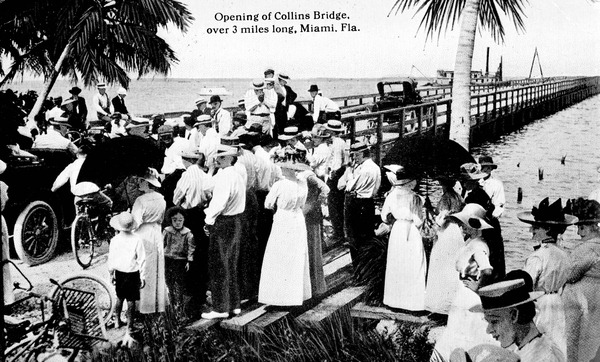
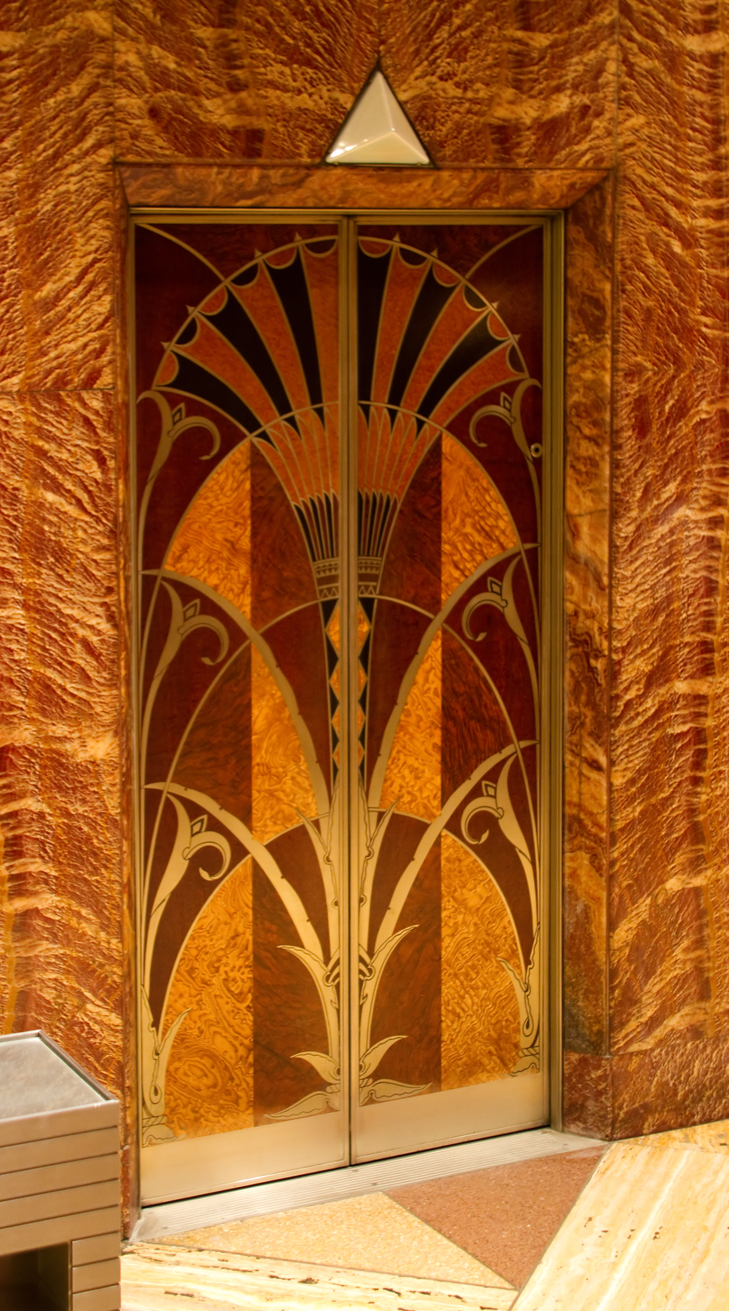
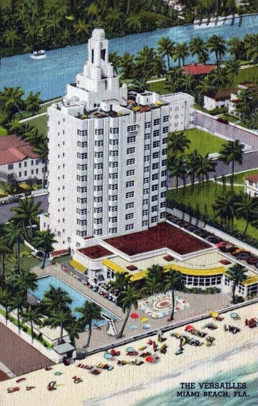
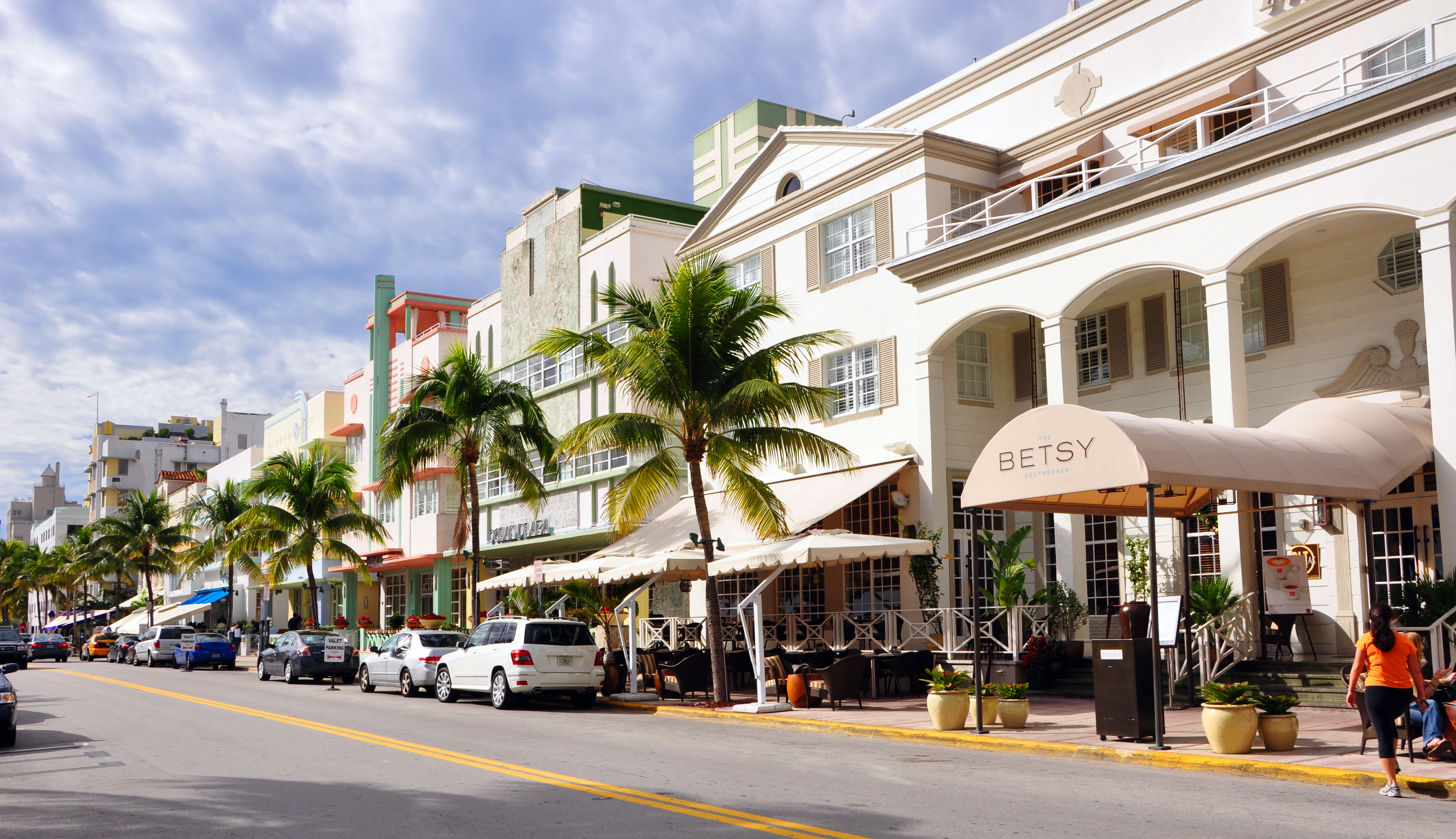
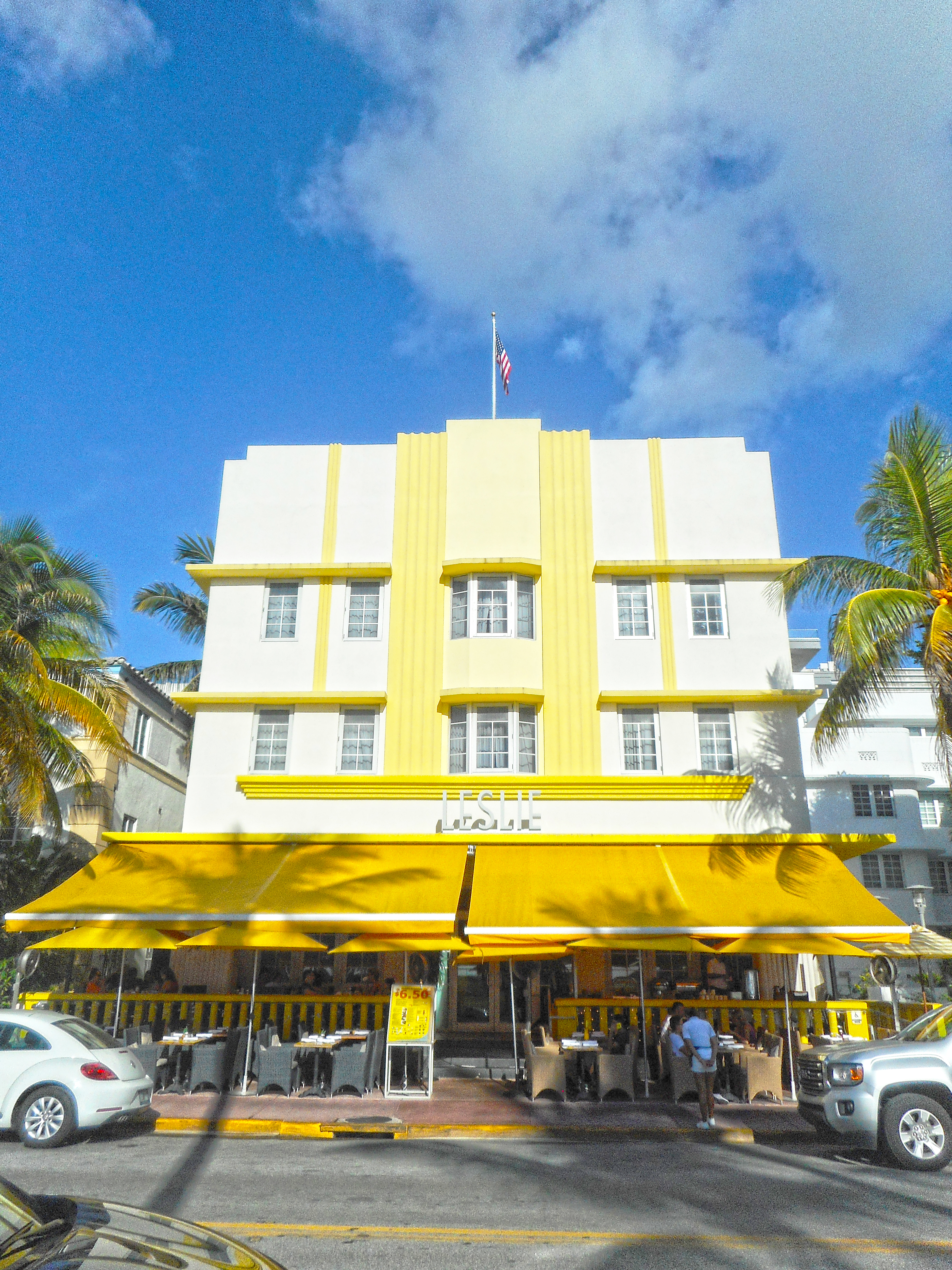
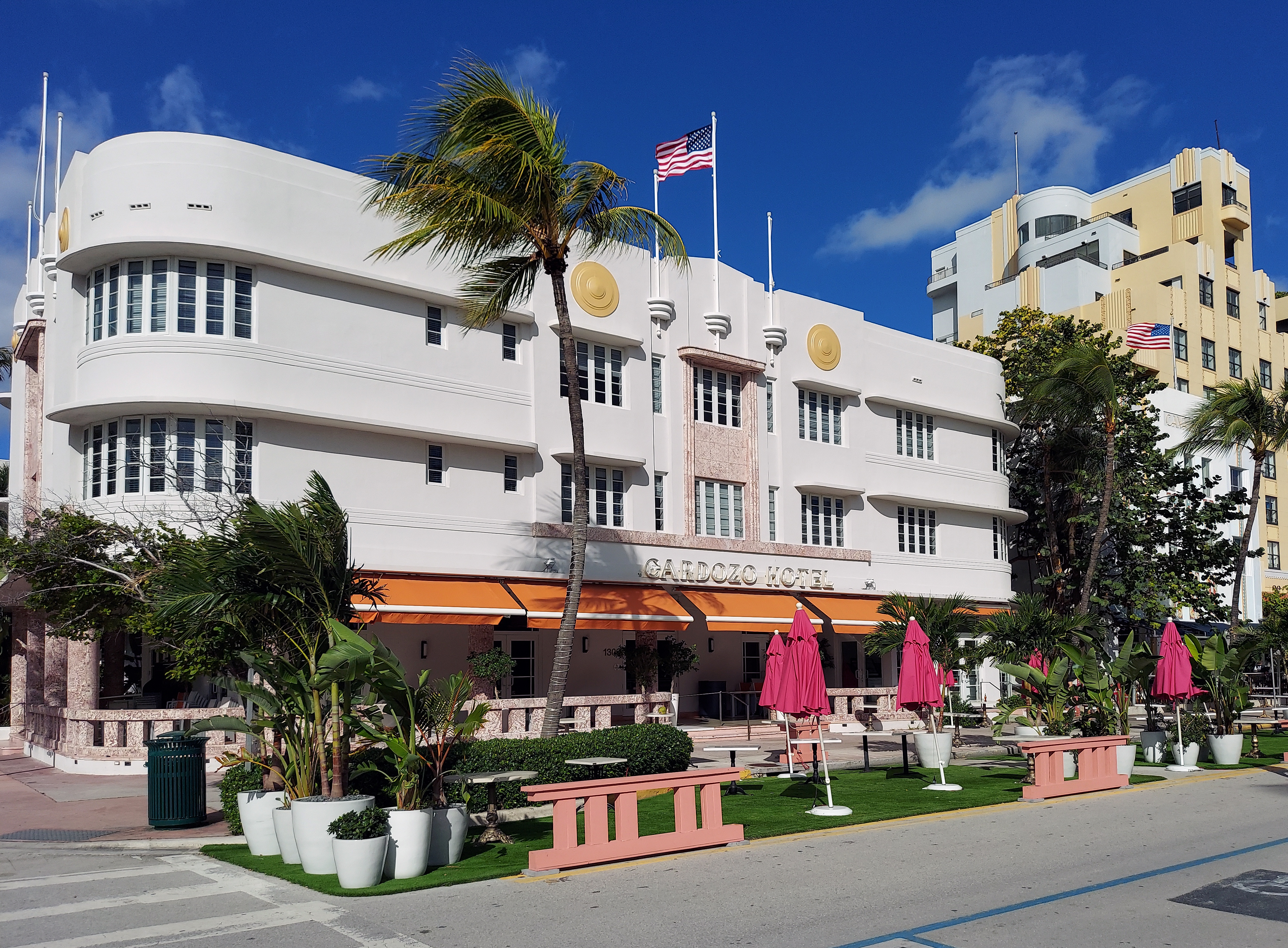
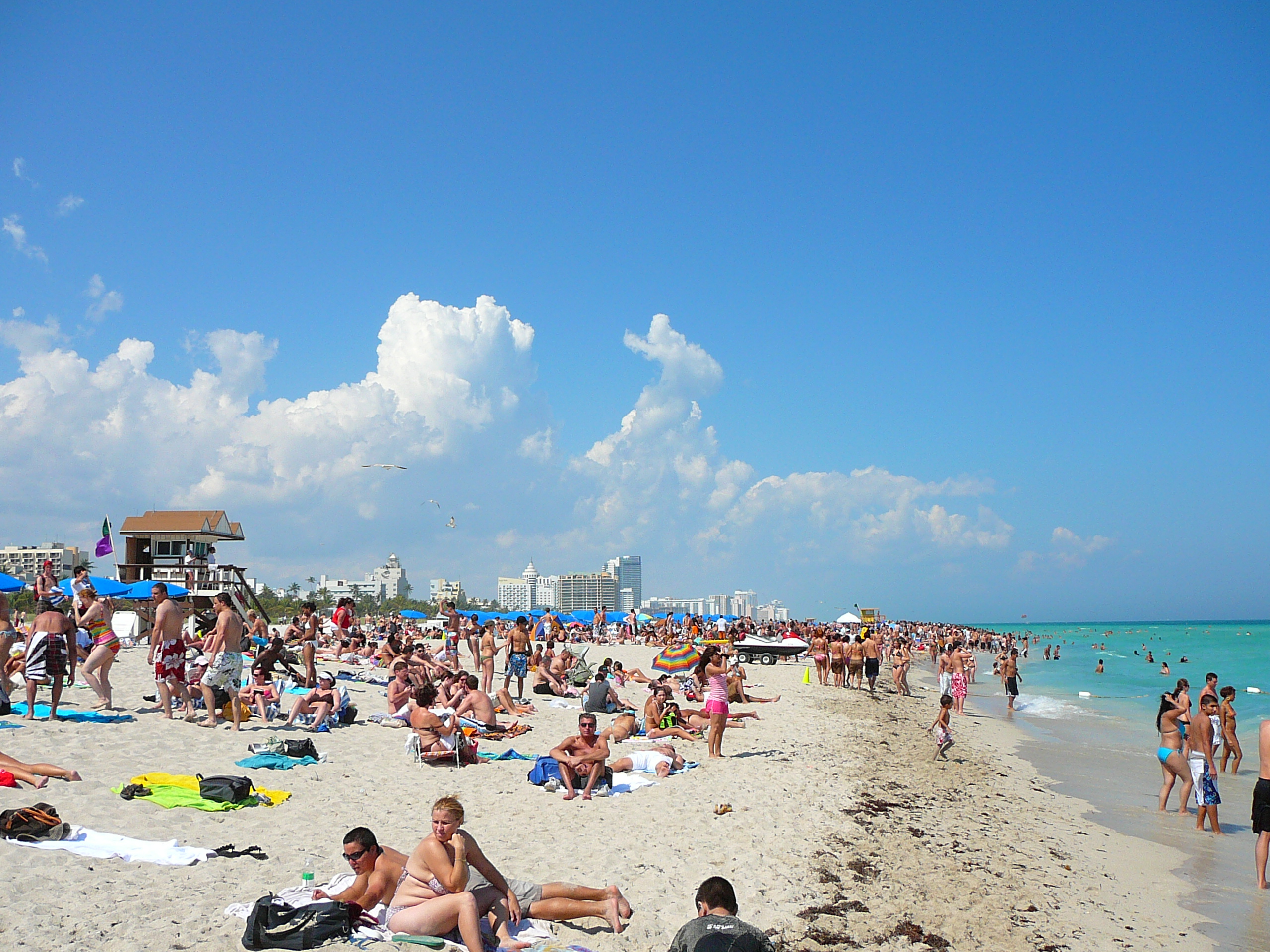
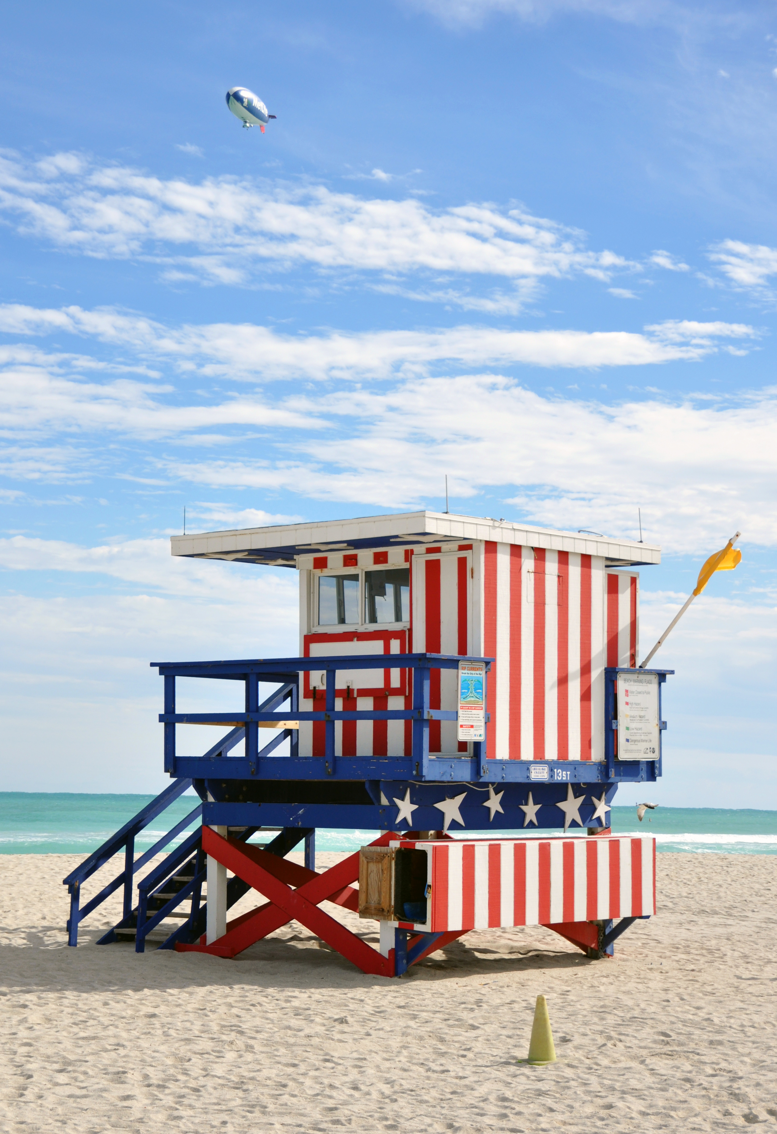
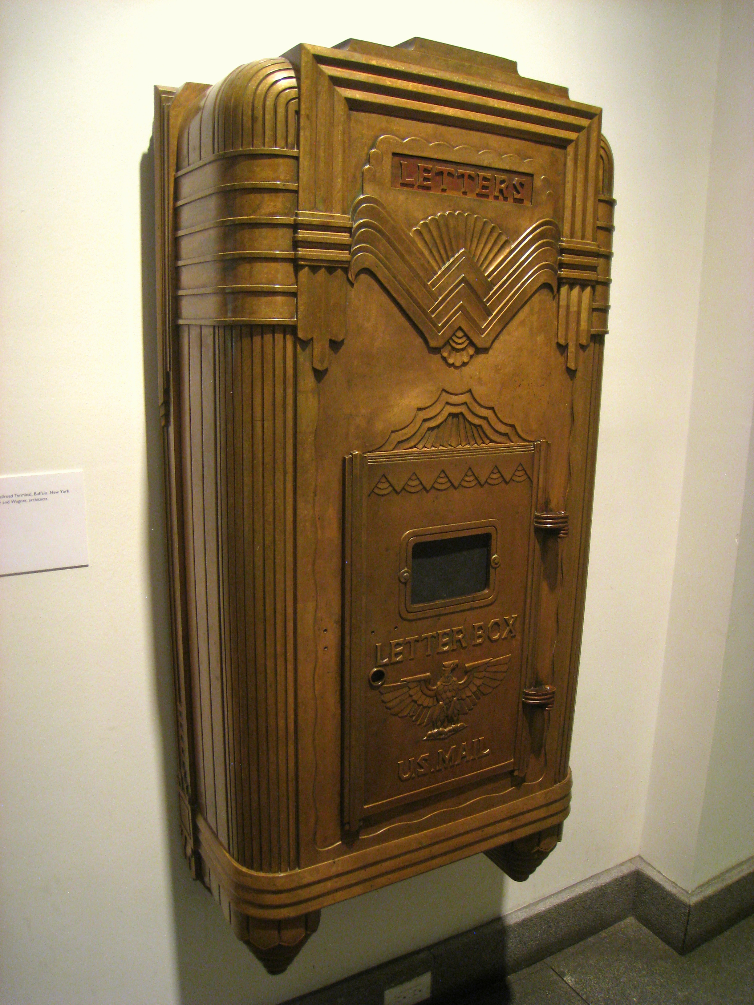
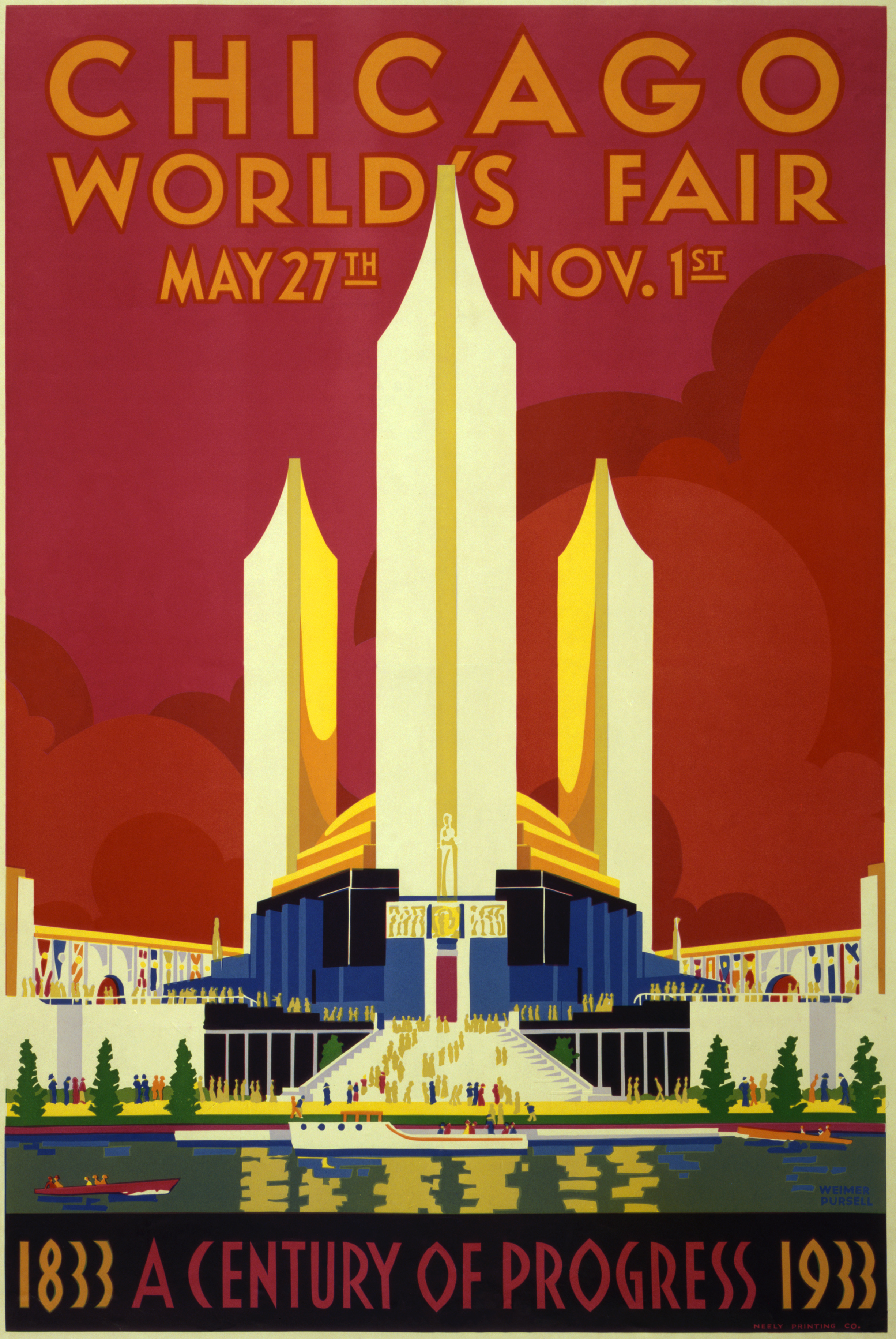
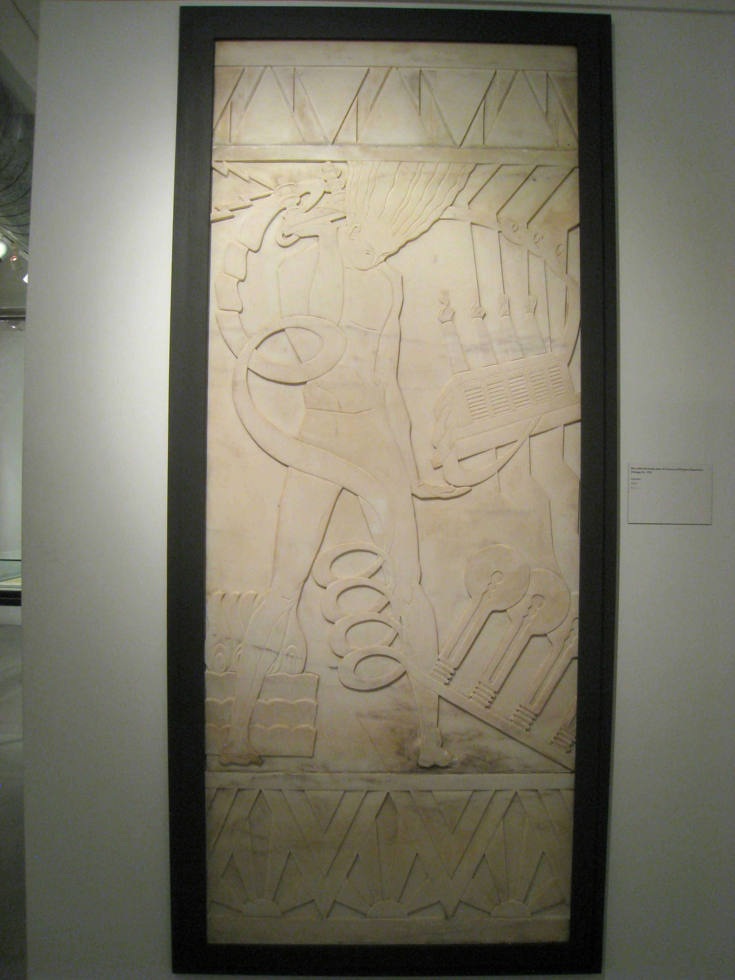
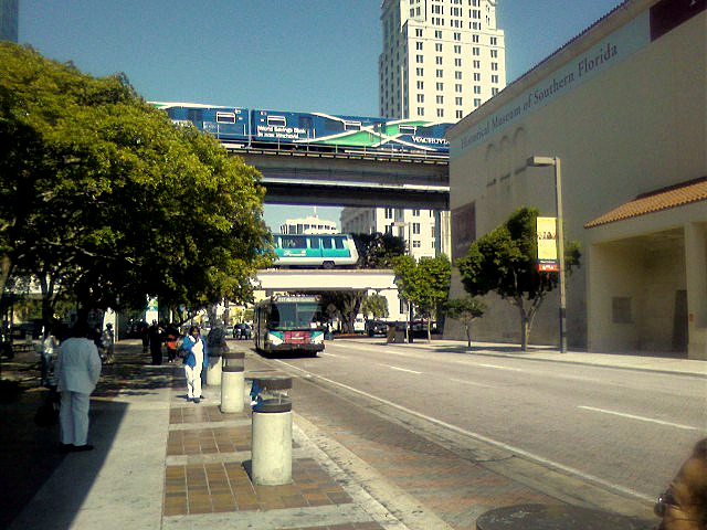