|
Reflections 2017
Series 8
June 8
Montréal-NYC Rail & Sail VI: Arrival in New York City
| | Arriving at, or departing from, a big city by ship can be an enthralling experience. Not particularly so in places where the ship just pulls up and docks, like parking a car. To be really impressive, there has to be a grand arrival (or departure) route. I think particularly sailing down the Elbe departing from Hamburg on the Deutschland in 2000, and on the QM2 in 2006. Also, to my pleasant surprise, the recent arrival in Baltimore in 2016 was exceptional. | | | | But New York is the best. New York arrivals and departures involve skylines, famous buildings, and monuments completely surrounding you. But all of those involve ocean access to the south, right? Who would have thought—not I—that river access from the north would not equal, but actually surpass, any previous arrival experience I've had. | | | | There's one other factor I hadn't expected—emotional pressure. It's not too bad when leaving. You want to see the ship and fully check out your cabin, but then you want to rush up on deck to see the departure. The pressure is worse when arriving. Liners once would arrive at any time of day, since they had to spend days taking on coal and preparing to "turn around". But today, it's in-and-out. Ships arrive at the crack of dawn, drop off, then embark passengers, and leave in the late afternoon. Passengers wanting to enjoy the arrival have to get up in the dark, finish packing, rush a breakfast, and trip over themselves to get up on deck to see anything. | | | | But our mid-afternoon arrival downriver in perfect weather allowed us to see it all at our complete leisure. No packing was involved, since once we docked at the Chelsea Piers, we'd be staying on board two nights! It was as relaxed and unpressured an arrival as could be. | | | | Dutch Names in the Hudson Valley One of the first places we're going to come to is Spuyten Duyvil, so we can now say that three Dutch names in the Hudson Valley are problematic for non-Dutch speakers, Kykuit, Valatie, and Spuyten Duyvil. We discussed Kykuit, the Rockefeller Estate near Sleepy Hollow in the last posting, but I neglected to mention Valatie, which is virtually a twin village with Kinderhook up north. I've driven through Valatie several times, but always stumbled over the name. On the boat, I met two women from Valatie, a married couple, and often dined with them. It seems that locals are used to outsiders mispronouncing the name, but it still upsets them. | | | | Believe it or not, Valatie is NOT an almost-rhyme with "malady (Valaty?)". Gird yourself, it actually rhymes with "Croatia"! (Valaysha?) It's a village with several waterfalls, which the name is all about. The first European settlers were the Dutch who settled Kinderhook around 1665, and named this area "Vaaltje", which means "little falls". When I read this, I became dubious. What's the AA spelling all about versus the modern-day spelling with A? And how did two syllables become three? | | | | The Dutch word for [water]fall is [water]val, and val has a short A. The spelling Vaaltje shows AA, meaning a long A, but that must just be an archaic spelling, and an anomaly that has since been corrected. The name is a diminutive, like kitchen/kitchenette, fall/"fall-ette", though we'd say "little falls", like the name of Lindbergh's home town in Minnesota. | | | | I know that the diminutive takes several different forms in Dutch, depending on the word. Needing more help, I looked it up online and, of four possibilities, two forms are appropriate here,–tje and –etje. | | | | The diminutive would be –tje if it were following a LONG vowel + L. This not being the case is further proof that the vowel is short and NOT long, and just has an outdated spelling. Even with that spelling, Vaaltje would be two syllables long, not three. For a short vowel + L, –etje is used, which is the basis for the town's three-syllable name. | | | | I would say an adjusted spelling version of the original name would be Valetje, with three syllables as it is today, and pronounced, roughly, VA.la.tyeh. We can see how perhaps English speakers heard and wrote –la- for the middle syllable –le-, but why did they have to move the stress from the first to middle syllable? They also might have been nonplussed with that J (=Y), altering the last syllable to –tie. What a mess when one language overlays another! Looking at the current spelling of Valatie, think of "Croatia", but also "inertia, Portia". Perhaps if they'd respelled it as Valatia, people would know how to pronounce it! | | | | The third name is closer to home, and is the one we're about to encounter, Spuyten Duyvil. We discussed it in 2011/8 but since we're visiting it now, we'll restudy the phrase here and discuss it. The western end of the Harlem River (technically the Harlem River Ship Canal), where it joins the Hudson, also goes under the name of Spuyten Duyvil Creek, and Spuyten Duyvil is the name of the Bronx neighborhood that abuts it to the north. It's a shortening by one syllable of the actual Dutch name, which was Spuytende Duyvil, in modern spelling Spuitende Duivil. Both words have that same awkward-for-outsiders UI that Kykuit has, a diphthong pronounced with an Ö followed by Ü. The Dutch pronunciation is something like SPÖÜ.ten.da DÖÜ.fel). There were strong and wild tidal currents in this creek, and since spuiten means to spout, to spray, and since the –D- in the extended first word in Dutch (and German) corresponds to -ING, the name corresponds to something like Spouting Devil. Actually, my guess is that they were going for something like Devil's Rapids, but expressed it in a quainter way. To pronounce it in local fashion as New Yorkers do, be guided by the words "spite" and "dive", and say "spite'n dive'l". | | | | But before we go into details on our arrival, let's set up some parameters. We said in the last posting as we left the Tappan Zee Bridge that the Palisades on the west shore started in about that area and went well down into New Jersey. To clarify that, let's point out that the Palisades are a line of steep, basalt cliffs along the west bank of the Hudson running for about 32 km (20 mi) from NY south to NJ, roughly between Nyack NY at the Tappan Zee Bridge to Jersey City NJ. At their northern end, the cliffs rise nearly vertically near the river's edge, and are about 91 m (300 ft) high at Weehawken NJ, across from Midtown Manhattan, and gradually increase to 165 m (540 ft) at their northern end. This is the view from Hastings-on-Hudson across to the Palisades (Photo by PointsofNoReturn), right at the point where the state line is located, with NY to the right and NJ to the left. North of Fort Lee at the George Washington Bridge, the Palisades are most spectacular, are part of Palisades Interstate Park, and are a National Natural Landmark. Palisades Interstate Parkway runs north from the George Washington Bridge area into NY State. At the southern end of the Palisades into Jersey City, they veer away a bit more from the river's edge and perhaps at that point, people think of them just as a local ridge and less as the Palisades, although they still are.
http://www.ontarioarchitecture.com/firstNations/FWfence.jpg
| | | | The name is really quite unusual, since a palisade (above) is actually a wooden fence made of stakes pointed at the top, used for defense, the same as a stockade. The Stockade Area of Kingston might have looked like this. The word is based on the Latin word for "stake" palus. Apparently it was named for its fence-like appearance.
http://www1.nyc.gov/assets/planning/images/content/pages/data-maps/maps-geography/city-neighborhoods/mapview.jpg
| | | | I found this map helpful, since it shows New York's five boroughs overlaid on a physical map. Note how on the east bank cliffs run along the Bronx and Upper Manhattan, which explains the name of the Washington Heights neighborhood. But on the other side, note how the Palisades run abruptly close to the river before moving further inland at their southern end in Jersey City. | | | | | | But we cannot leave this map without referring to how well it illustrates a topic we discussed on 2010/26, the Outer Lands. This map shows better than any I've ever seen the glacial moraine still remaining today across Staten Island, then across Brooklyn, Queens, and going further onto Long Island. Part of the Outer Lands are south of this ridge which is clearly visible. This ridge is visible in the Brooklyn Botanic Garden, near Eastern Parkway, and is the basis for the aptly named Highland Park near which I grew up in East New York. Since ENY is just south of the park, I suppose I was an Outer Lands baby.
The ridge also shows how the Hudson cut through it to reach the ocean, but accounts for the narrowness of the Narrows between Staten Island and Brooklyn. But I'll pose this question: the outflow from the Hudson from the Great Lakes, either via the Mohawk, or later via Lake Champlain, would have been stronger than when all that water shifted to the St Lawrence, and the Hudson was left just draining itself and the Mohawk. Would the newer Hudson have been strong enough to eat through the Narrows? My guess is no, meaning it must have happened earlier.
|
| | | | Some time ago, I was driving on the Palisades Interstate Parkway and made it a point to stop at the two lookouts over the river. We'll be using this map as we sail along the city (our "City Map"), so let's take a look at it now:
http://www.vidiani.com/maps/maps_of_north_america/maps_of_usa/large_road_map_of_New_York_city.jpg
| | | | Click at the top center to inspect the Palisades, the Park, and the Parkway (in red atop the cliffs). Further north, in Alpine NJ, is the Alpine Lookout. It has a nice river view, but just faces the city of Yonkers, the southern end of which abuts the Bronx on the east shore. Much better is, in Englewood Cliffs (an appropriate name), the Rockefeller Lookout. It's not shown on the map, but is just north of East Palisade Avenue, allowing it to look almost directly across to Spuyten Duyvil, which is a water confluence that also developed, quite curiously, into a rail diversion. Story to follow. For now, note how the Harlem River (Spuyten Duyvil Creek) enters the Hudson. Note the rail line coming up from Manhattan that crosses Spuyten Duyvil Creek to continue into the Bronx, Yonkers, and beyond. Finally note how the rail line on the Bronx side turns a curve to go down the north bank of the Harlem River. | | | | Rockefeller Lookout has two killer views. First, you look east right into the Spuyten Duyvil area. Click for details. We're looking east, so Yonkers is off the picture to the left. First we see the hilly Riverdale neighborhood of the Bronx, then its Spuyten Duyvil neighborhood, then the Harlem River/SD Creek, followed by Inwood Hill Park in the Inwood neighborhood, the neighborhood furthest north in Manhattan. (Columbia University has an athletic center at the northern tip of Manhattan and that unfortunate white blob is a tennis facility.) But note the Spuyten Duyvil rail bridge, and to its left, the track that goes along the Harlem River. More later. | | | | The second spectacular view from Rockefeller Lookout is the southeast view (click) of the George Washington Bridge and Midtown Manhattan (Both lookout photos by Famartin). The point in the middle is the Empire State Building. While we can't see much of Lower Manhattan, that hazier, more distant tall building is the new one, One World Trade Center. We'll continue to see more of the Palisades as we move downriver. | | | | Day 12 (later): New York City We left Kingston/Rondout early this morning, stopped in West Point late this morning, and have come past the Tappan Zee Bridge to enter New York City. As we said in the last posting, New York is a story unto itself—it's the Big Apple, which other languages are aware of: Dutch: de Grote Appel; German: der Große Apfel [ß=ss]; Swedish: det Store Äpplet; French: la Grosse Pomme; Spanish: la Gran Manzana; Italian: la Grande Mela; Portuguese: la Grande Maçã; Russian: Большое яблоко / Bol'shoye yabloko [bol'.SHO.yeh YA.bla.ka] | | | | Spuyten Duyvil With constant views of the Palisades on our right, we soon pass the New York City line between Yonkers and the hilly Bronx neighborhood of Riverdale.
http://ontheworldmap.com/usa/city/new-york-city/map-of-bronx-neighborhoods.jpg
| | | | Click to see that Riverdale (listed here under several local neighborhoods—some even include Spuyten Duyvil as part of Riverdale) includes the northernmost point in all of New York City. I recall that the Captain made an announcement erroneously saying Riverdale was in Yonkers—not so. But Spuyten Duyvil and Manhattan's Inwood do face each other across the Harlem River. Inwood Hill Park, on both maps, is non-landscaped and largely natural, and is known for containing the largest remaining forest land on Manhattan island. (For the moment, take note of Port Morris in the southern Bronx.)
http://cdn.shopify.com/s/files/1/0977/4104/products/NYC-XX-983802_78fa2727-5915-48ed-889a-a313cef46bd8.jpeg?v=1483551339
| | | | While the last map showed neighborhoods and waterways, we have to add this similar map (click), since it shows the rail connections involved, being the other half of the water-and-rail junctions here. We'll keep on following it in a moment. | | | | Spuyten Duyvil began to develop as a neighborhood in the latter half of the 19C when the Hudson River Railroad came through (2011/8). Now that we've been to Troy, it's curious to note that this railroad started out in 1845, when the Troy & Greenbush Railroad began construction. (How delightfully ironic! Greenbush is now Rensselaer, opposite Albany, site of today's Albany-Rensselaer station. This means that that's where it all started, and yet today, Troy has no rail connection to it or anywhere else!) The next year, 1846, the Hudson River RR was charted to extend that line to New York City. That means our ride on the Adirondack two weeks ago was all on former Hudson River RR trackage. | | | | | | I really must insert here one of the many things I learned years ago when we visited the delightful Sunnyside of Washington Irving. He was—understandably—very upset when he heard a railroad was being built that would cut off his front yard from the Hudson. |
| | | | When the line came as far south as Spuyten Duyvil, a wooden bridge was built in 1849 to cross the creek into Manhattan (the current steel bridge dates from 1900). But while the railroad had an upper city station in the area of 34th Street—west of where Penn Station is today and in what are now Penn's rail yards—the line continued south to its principal city station called the West Side Station, way down at Chambers and Hudson Streets, almost where Battery Park City is today. Track went down 10th Avenue (where the High Line still is today), then I believe down Washington Street to Canal Street to Hudson Street to the station. | | | | This map we used in that earlier posting of Port of New York Railroads c1900 (Map by James R Irwin) shows where the railroad went in Manhattan, though already incomplete. The southernmost segment is already gone, and the line stops at St John's Park Depot. But looking at it from what we know today, let's consider that as about four segments. | | | | The first segment, from Inwood, went down along the river, often in tunnels, to where later on the Penn Station rail yards were built. It's been revived, and we used its full length from Penn to Spuyten Duyvil, then beyond to Albany. The second segment was from there to Gansevoort Street in the Meatpacking district, which was eventually elevated through buildings and is today the High Line, which ends abruptly right at Gansevoort Street. The third segment, from there to St John's Park, had also been elevated through buildings, but was demolished before the High Line became trendy (and don't those property owners regret having missed out on a good thing!). For the record, what was St John's Park now contains the ugly exit ramps for the Holland Tunnel. Before that, it contained the Hudson River RR Freight Terminal. The fourth segment, and obviously the first to go, was from St John's Park to the West Side Station at Chambers and Hudson Streets. But now reassemble all those segments to where this was a thriving line about to die. | | | | In 1869, Cornelius Vanderbilt acquired and merged the Hudson River RR with his New York Central, which already owned the New York & Harlem Railway, which went up central Westchester. He decided he wanted both these routes to go down Manhattan's East Side to reach Grand Central Terminal. To that end, the Spuyten Duyvil & Port Morris RR was built in 1871 and leased immediately by the NY Central. It split off in a fork at the Hudson and followed the north shore of the Harlem River to both a connection to the Harlem RR, and then beyond to port facilities at Port Morris, a section that was eventually abandoned. | | | | Inspect this on the second Bronx map from the fork down to the merger with the Harlem in the South Bronx on what is an extension of New York's Park Avenue, with both then crossing into Manhattan down to Grand Central. You can also see this very clearly on the 1900 rail map. These two routes are still valid, and with the additional of the New Haven trackage from Connecticut form the basis for the three lines we recently saw when we discussed the Tappan Zee Bridge, the Hudson, Harlem, and New Haven Lines of what is now the Metro-North railroad leading into Grand Central. | | | | So what happened with the original segment of the Hudson River RR south of the fork and bridge at Spuyten Duyvil? After the fork, both lines were used for passenger travel, but you can see the handwriting on the wall, there was minimal service offered on the West Side, although a station at 23rd Street did accommodate ocean liners docked at what is now the Chelsea Piers. As passenger service was reduced, it remained for freight to the docks along the river, until that stopped, too (explained on the history of the High Line, which we'll be getting back to shortly). So let's watch it die. The southernmost section went first, leaving the next two sections to Penn Station. Before High Line Park interest was aroused, that second section was demolished. The third section is the revived High Line, but the best story is north of Penn. While disused for many years, once all Amtrak service was moved out of Grand Central to Penn the West Side Line was refurbished for use again northbound, as we rode it. | | | | I think the rail 'n' sail intersection at Spuyten Duyvil is very photogenic, and I found a good collection of photos to show that. Looking from across the Hudson to Spuyten Duyvil (Photo by Gary Miotla), the most striking feature we haven't even discussed yet, the Henry Hudson Bridge for road traffic between Spuyten Duyvil on the left and Inwood on the right. Click to check the forest in Inwood Hill Park and the tracks at the riverside as they cross the Spuyten Duyvil Bridge—but not now, it's open. You can see that its original two-track capacity is now down to one. Clearly obvious is the fork, separating transportation worlds between intercity traffic going over the bridge to Penn and local commuter traffic to Grand Central down the Harlem River, which has a stop right there at Spuyten Duyvil. If you—or a drone—flies around for a west view, this would be it. (Photo by Metropolitan Transportation Authority of the State of New York.)
| | | | This view of the closed Spuyten Duyvil Bridge (Photo by Jim.henderson) includes a nice shot of the Palisades. So does this sunnier view, but the bridge is open for a Circle Line boat (Photo by TheTurducken) to pass into the Hudson. Here's the open bridge in a water level view looking north at the Bronx from Manhattan (Photo by Beyond My Ken). | | | | But trains stopped running across the bridge in 1982, and the following year it was damaged by a vessel and left stuck in the open position. The bridge was finally rehabilitated in the late 1980s and, after finalizing the new connection, Amtrak's Empire Service began using it in 1991. The bridge is used by about 30 trains a day and is opened over 1,000 times per year, mainly in the summer for the Circle Line as above. | | | | This is the Spuyten Duyvil Metro-North station (Photo by Anthony22) with the creek and bridge and here we look down to the station (Photo by Jim.henderson) from the Henry Hudson Bridge (click) with our first view of the fork. | | | | Here's a much better angle, looking south, to see the iconic view of the fork (Photo by Daniel Case at the English language Wikipedia). Amtrak trains go to the right down what is now called the West Side Line—see the George Washington Bridge in the distance—and Hudson Line commuter trains to the left—look for the third rail--to stop at the Spuyten Duyvil station first near the Henry Hudson Bridge above. | | | | But the curve you see to the left has more history to it when two events happened in 2013. On 18 July, a freight train derailed near the station, without casualty, due to excessively wide gauge at one point. But less than 4 ½ months later on 1 December, a commuter train derailed due to excessive speed near the station resulting in four deaths and over 70 injuries, 11 critical, plus $9 million worth of damage. It was the first accident in Metro-North's history with passenger fatalities. The train had entered the curve you're looking at at triple the posted speed. The engineer admitted he had gone into a daze of some sort, kind of highway hypnosis, which was later judged to be sleep apnea. This is a sketch of the eight cars (Map by Daniel Case) at the derailment site, which shows the fork quite accurately, and this aerial view also shows it quite well. | | | | But on to happier things. As we sailed by, we had a super view of every aspect of Spuyten Duyvil, and I couldn't believe my good luck. In the very few minutes it took to pass by the area, I (1) saw a southbound Metro-North train pass around that curve, then a northbound one; (2) right after that, an Amtrak train out of Manhattan went northbound over the bridge; and (3) as soon as it passed, the bridge swung open for a boat to come out into the Hudson. In no time at all, I'd had the Spuyten Duyvil rail 'n' sail trifecta!
https://s-media-cache-ak0.pinimg.com/736x/e5/0c/f8/e50cf8b080f31b544b4479e087d0e095.jpg
| | | | Upper Manhattan Neighborhoods, and particularly their borders, are usually defined very imprecisely, and so it is in Manhattan (see above). This map will do us well for Upper and Mid-Town Manhattan—I'll mention some items I disagree with—but it's so bad for Lower Manhattan that I have another map prepared. | | | | Upper Manhattan certainly includes its northern end, but once it gets wide enough, it's thought of as "sides"; just as London has its West End and East End, New York has its West Side and East Side. But those terms are not always used throughout. Largely based on Central Park, we have the famous Upper West Side and Upper East Side (noted left and right on the map), and largely based on its varied ethnic history, we have the Lower East Side, a term so ingrained in immigrant history that it's often called in Spanish la Loisaida. The Lower West Side, though, is referred to only rarely by that term. But we will concentrate on the entire western side of Manhattan, closest to us here on the Hudson. | | | | Back to the North, on our City Map. You see where Inwood Hill Park, after the valley of Dyckman Street, becomes Fort Tryon Park. South of that, all unnamed, are Hudson Heights and, beyond the George Washington Bridge, Washington Heights and Hamilton Heights, but others would argue that this three-way division is really all one, that the other two are subneighborhoods of Washington Heights. Yet from these names we see there are hills on this side of the river, at least this far south, to match the Palisades on the other side. The neighborhood map does show three neighborhoods here, but calls Hudson Heights Fort George. You can't win. | | | | Looking from our boat to the left, we get this view (Photo by Jim.henderson). That's the southern end of Inwood Hill Park, the valley of Dyckman Street then Fort Tryon Park, on top of which are the Cloisters, the medieval collection of the Metropolitan Museum of Art, located north of 190th Street. Coming south from the Henry Hudson Bridge over Spuyten Duyvil we see the elevated Henry Hudson Parkway (in green). As for rail, the West Side Line would be closer to ground level.
| | | | We continue along high ground. In a park between 185th and 183rd Streets is the highest natural point in Manhattan at 80.79 m (265.05 ft) (Photo by Beyond My Ken)--the inset shows the marker in the rock outcropping. | | | | At 181st Street, we reach the George Washington Bridge (GWB), and here we turn our view to the right for another view of the Palisades on the NJ side, shown her in the autumn (Photo by Seidenstud). The town you see on both sides of the bridge on the NJ side is Fort Lee, site of Bridgegate, more formally the Fort Lee Lane Closure Scandal. | | | | On a more pleasant and much lighter side, this other view of the GWB includes the Little Red Lighthouse here on the Manhattan side (Photo by Pgelfan), officially the Jeffrey's Hook Light. It had become obsolete and been moved from Sandy Hook NJ to this point in 1921 to improve river traffic around this projection of land, known a Jeffrey's Hook (see City Map). But after the GWB was built, with its eastern pier also resting on Jeffrey's Hook, the lighthouse was again deemed obsolete, although it still functioned. | | | | It was made famous by the 1942 children's book The Little Red Lighthouse and the Great Gray Bridge by Hildegarde Swift, although the GWB was never mentioned by name. The lighthouse fears it'll be replaced by the new light on top of the bridge, but on a foggy night, the boats can't see that high and a tug crashes, at which point the bridge tells the lighthouse it's still needed, with the moral that even the small are important. The book ends by encouraging readers to go to Riverside Drive in New York City and see for themselves the Little Red Lighthouse next to the Great Gray Bridge, which continued to remain unnamed in the book. | | | | The Coast Guard finally decommissioned the Jeffrey's Hook Lighthouse and put out its light in 1948. I suppose we can all imagine the public outcry that resulted, largely from readers of the book as well as preservationists. It was then deeded to the NYC Department of Parks. The Jeffrey's Hook Lighthouse was listed on the National Register of Historic Places in 1979 and was designated a NYC Landmark in 1991. In 2002 the Little Red Lighthouse was relighted by the city. We could all see it from the boat, but I doubt many passengers knew its background, and they would have instead been gaping at the Great Gray Bridge above their heads, anyway. | | | | | | While the bridge was meant to be great from the beginning, it could have been a different shade of gray, since the original design for the towers called for them to be encased in concrete and granite, which would have made it look similar to the Brooklyn Bridge. In other words the towers we see were meant to be just the skeleton of the towers. But it was the Great Depression and funding ran low. Also it was felt then that the criss-cross bracing is attractive, and that thinking still prevails.
With Jeffrey's Hook, as in the last posting, we've now come across the word "hook" again, as in Kinderhook, Sandy Hook, and so on, part of the Dutch Heritage of the Hudson Valley, but where hoek was mispronounced and mistranslated as "hook". Again, it indicates a bend in the shoreline, as the City Map clearly shows. Take a quick look at some others. Run downriver for a moment to where Jersey City bulges out at Paulus Hook; swing over to the East River on the Manhattan side of the Williamsburg Bridge where Corlears Hook bulges out; move down to Brooklyn south of Governors Island where the neighborhood of Red Hook bulges out, and then further south in Brooklyn, at the Verrazano-Narrows Bridge, to the neighborhood of Bay Ridge, once called Yellow Hook. Now move back to where we were in the GWB area.
|
| | | | The Hudson River Railroad was built along the west side of Manhattan in 1846 on otherwise undeveloped land. The concept then developed to improve the section from 125th down to 72nd Streets, and the famous landscape architect of Central Park, Frederick Law Olmstead, designed Riverside Drive as part of Riverside Park. From 1875 to 1910, architects and horticulturalists laid out the park and road over that stretch, creating the appearance that the park was an extension of the Hudson Valley. | | | | Then in the 1930s Robert Moses covered the railroad tracks of the West Side Line in that same stretch with a tunnel, also creating the Henry Hudson Parkway. It was so skillfully done, that many believe the park and road are set on a natural slope. | | | | However, this is a view in Hamilton Heights (Photo by Jim.henderson) of the part of Riverside Park, where the Riverside Drive Viaduct runs from 135th to south of 125th Streets. The Henry Hudson Parkway is still visible, in green. | | | | We reach Harlem and, south of 125th Street, Morningside Heights, which includes numerous cultural institutions, such as Columbia University, and Columbia University Teachers College, each of which I attended for a semester of graduate study in 1963-1964, and also the magnificent Cathedral of St John the Divine. But we can see only two of them from the river, since they're both on Riverside Drive. On the left, at 122nd Street is what is officially the General Grant National Memorial, but which everyone calls Grant's Tomb (Photo by BriYYZ), and we all know who's buried there. To its right is the tower of Riverside Church at 120th Street. | | | | We pass Manhattan Valley, part of the Upper West Side, which many would say also includes Lincoln Square in the area of Lincoln Center. For the purpose of this posting I listed friends who physically resided in Manhattan. While one was on E 96th, in the Carnegie Hill section of the Upper East Side (which is also not necessarily as splintered as the neighborhood map shows), all the others I note are on the Upper West Side, on W 93rd, W 81st, W 79th, & W 75th. This means they're all within 18 blocks of each other, and E 96th is very close to W 93rd. That's a concentrated area, yet they know each other only through knowing me. I'd never thought about big-city life in those terms before. | | | | Midtown Manhattan As the neighborhood map indicates, Midtown [Manhattan] starts at the bottom of Central Park at 59th Street. It also says it ends at 34th Street, but that's arguable, since many would drop it down to 14th Street as shown by Midtown/Midtown South in the center. What this map goes on to show as neighborhoods are subdistricts, since, for instance, I can't picture the Theater District as being anything more than a part of Midtown. I also do not see why, closest to us here on the Hudson, this map divides Clinton and Hell's Kitchen as they do, which is nonsense. Those two names refer to exactly the same neighborhood, which runs, as they do show, between 59th and 34th Streets. | | | | Midtown has iconic buildings, such as the Empire State Building, Chrysler Building, and UN Headquarters. It includes Rockefeller Center, Times Square, and the theatrical stretch of Broadway, a street that otherwise runs the length of the island, and continues north to Albany. Midtown is the largest central business district in the world, and includes some of the most expensive real estate. The Midtown section of Fifth Avenue in 2017 commands the world's highest retail rents at $32,000/sq m ($3,000/sq ft). | | | | Manhattan has two central business districts, the other being Lower Manhattan. While Lower Manhattan's Financial District remains the main financial center, in an around Wall Street, Midtown is the largest commercial, entertainment, and media center in the US.
https://www.nycruise.com/content/uploads/2012/06/mct_piers_94_86.jpg
| | | | From our point of view on the Hudson, the part of Midtown we see puts the Empire State Building on 34th Street well to the right (above), while we're right at the New York Passenger Ship Terminal NYPST) in Clinton/Hell's Kitchen. [For later reference, note that Pier 90 (to the left), and Pier 88 (in the center) are faintly marked in blue near the water line. Pier 88 is at 48th Street, and we're looking straight down the length of that street.] | | | | | | I do understand that different people enjoy travel in different ways, some perhaps less understandable than others. Some may be highly unoriented, even disoriented, but that's how they seem to like it. While passing Manhattan, I was asked questions by three people. I answered politely, but had to keep from biting my tongue. I'll only mention the most egregious question of the lot. A sweet dear sidled up to me at the railing as we passed the iconic, world-famous skyline of Midtown Manhattan as in the above picture and asked a question I'll always remember:
"Is this still the Bronx?"
I'm sure she was enjoying herself in her own way. She was looking at a version of Oz, or of a large amusement park, but apparently unaware of any significances beyond that. I'm afraid there's a lot of that going around.
|
| | | | On our visit we saw the Norwegian Breakaway docked at the NYPST, and later, when we were down in New York Bay, she sailed right past us, and I enjoyed these twin viewings from the river, even though I often see the Breakaway departing from my windows. | | | | The point we're going to make about this picture is that the Grande Mariner at this point is sailing exactly where the so-called "Miracle on the Hudson" took place, the emergency landing on the river of US Airways Flight 1549 on 15 January 2009. On our City Map locate, due east of Central Park, La Guardia Airport, the takeoff point. It was just three minutes after takeoff that the plane struck a flock of Canada geese near the George Washington Bridge and Captain Chesley "Sully" Sullenberger was forced to land immediately. I have the map of that flightpath, in red (Map by ChrisnHouston). You see that they landed mid-river off 48th Street (Photo by Greg L), which we looked down the length of next to Pier 88 in the earlier picture. An official of the National Transportation Safety Board described it as "the most successful ditching in aviation history" and the pilots and flight attendants were awarded the Master's Medal of the Guild of Air Pilots an Air Navigators for their "heroic and unique aviation achievement". | | | | | | In 2009/1, I described the winter sailing of the Queen Victoria from NYC via the Panama Canal to Long Beach (for Los Angeles). It was the trip where I got to know friends Neil & Joe—Neil commented recently on events in Montreal. I described in that posting how we heard en route about five days after we left about the plane in the Hudson. I also noted at the time that the QV sailed from 55th Street, which I now estimate to be Pier 94, while the plane went down off 48th Street at Pier 88, meaning we sailed over that site. I calculated then that the QV had sailed on the 10th at 5:30, and the plane went down on the 15th at 3:30, meaning it happened precisely four days and 22 hours after we passed that stretch of water. I never expected the Grande Mariner would sail me over that same site again.
I also heard that the plane ended up being towed to Battery Park City in Lower Manhattan, but never found out just where, but I do now (see below).
|
| | | | As for the routes we've been following, the Henry Hudson Parkway became the West Side Highway after 72nd Street, which actually uses local surface streets: 12th Avenue, leading into 11th Avenue, leading into West Street down to the Battery. We've already discussed how the West Side Line, now used by Amtrak, ends at Penn Station on 34th Street, the rest of the Hudson River RR south of that now having become the High Line, followed by a lost stretch at the southernmost tip. | | | | On the neighborhood map, we move a little further south and we're alongside Chelsea between 34th and 14th Streets and abutting the Meatpacking District just beyond. Now look at the City Map. The following picture was taken from Hoboken, very likely from that promontory, but also note how Manhattan bends at 23rd Street (which is why I can't see any further upriver than that from Battery Park City). Now look at this view of Chelsea and Midtown (Photo by Troydj). This view is much more from the southwest, as you can tell, since we're looking at the SW corner of the Empire State Building—you expect it on the left, but it seems to be in the middle. Click to inspect it and the pointed Chrysler Building to its left. Also notable on the skyline are two insurance buildings flashing gold. On the left is New York Life between 27th and 26th Streets, with its pyramidal gilded roof, and further right is the Met Life Tower, nearby at 23rd Street, with its clock faces and gilded cupola. But in the foreground are the Chelsea Piers, running roughly between 23rd & 17th Streets, where we'll be docking in a while (more later).
https://newyorkinoldwinnipeg.files.wordpress.com/2011/11/manhattanneighborhoods11-e1320518884505.gif
| | | | Lower Manhattan Aside from accurately showing the Meatpacking District, the neighborhood map we've been using thoroughly messes up Lower Manhattan as I see it. Let's now discard that map and move to this new one, as we come to Greenwich Village. | | | | | | That is, however, awkwardly shown here. The historic Greenwich [GREN.ich] Village lay along the Hudson. The westernmost part along the water was the heart of the village itself. Oddly, this is today called the West Village (avoiding "Greenwich"). Further inland lay what became in those days the upscale part of the village around Washington Square. THIS is what many, perhaps most, take to be Greenwich Village proper, and can be shortened to "The Village". I can live with that. In more modern times, the wholly unrelated area of Manhattan running from there to the East River has become known as the East Village (avoiding "Greenwich"), which simply means "east of The Village". I can live with that, too.
This map, although good for Lower Manhattan, distorts that, and has the labels wrong. It says Greenwich Village goes river to river which it does not. It implies all of Greenwich Village is the West Village and that that contrasts to the East Village.
Now look with fresh eyes at the map. Everything blue is Greenwich Village, with the West Village, a sub-neighborhood, being the part near us on the Hudson. Everything green is the East Village. All the other neighborhoods are accurately shown.
|
| | | | We pass the iconic Lower Manhattan neighborhoods of Soho and Tribeca, two gentrifying neighborhoods that never had names until urban planner Chester Rapkin started the trend of joining syllables to form names in the 1970s. He joined the first syllables of SOuth of HOuston (Street), and simultaneously made a reference to the Soho district in London. Tribeca stands for the TRIangle BElow CAnal [Street], a name notoriously inaccurate, since it's obviously a trapezoid. However, when first planned, it was smaller, and was a triangle. We then come to the Financial District around Wall Street leading to the East River, but which includes Battery Park City, built on the area of former Hudson River piers.
https://www.6sqft.com/wp-content/uploads/2015/08/nyc-subway-system-map-overlaid-over-manhattan-aerial-image-2-1024x755.jpg
| | | | There are a lot of things to see on this "colorful illustration", starting with the difference between the Midtown and Lower Manhattan Business Districts, each with its collection of skyscrapers, which require strong bedrock. Such bedrock is lacking in the "valley" in between the two areas and it simply does not support high structures. The bedrock there dips deep beneath the surface, and it would be underwater save for the sediments left there by glaciers. | | | | Manhattan is built on three layers of rock, Manhattan schist (SHIST), Inwood Marble, and Fordham Gneiss (say "nice"). The layers started out flat, as a sandwich. The Inwood Marble formed the marble beds beneath the Harlem and East Rivers and is visible forming a ridge from Dyckman Street northward to the appropriately named Marble Hill. The billion-year old Fordham Gneiss lies above the surface in the Bronx and forms that ridge in Riverdale, above Spuyten Duyvil. | | | | That's background, but to the point: Manhattan Schist runs the full length of the island as we sail along it, from the Henry Hudson Bridge to the Battery. But it dips abruptly quite a distance below ground at Washington Square in Greenwich Village and gradually ascends again at Chambers Street at the start of the Financial District. What caused this huge dip?
http://eatrio.net/wp-content/uploads/2013/01/10.-pangea_politik.jpg
| | | | About 500 million years ago, North America and Africa were in the process of colliding, beginning to form the supercontinent of Pangaea (above--click), also spelled, more sensibly, Pangea. This we've shown before and it shows where Brazil bulges into Central Africa and West Africa bulges into the Carolinas. Some 50 million years later, what is now New York City ended up being located on the seam where the two had come together. The impact of the collision squeezed the land between the two and created ups and downs, as when you push a tablecloth across a table, folding the bedrock into dips and folds. The dip between the two skyscraper areas in Manhattan is one of these, which later filled with glacial sediment. But all this compression has made Manhattan schist an exceptionally hard rock. | | | | Some additional background: the NYC area later became subject to volcanic action, and about 200 million years ago, dark, volcanic basalt rose to form the Palisades. At that same time, the supercontinent broke up again, and NYC ended up once again on the coast, where it had started out. | | | | Back to the "colorful illustration". This is the area we're going to be sailing in this afternoon after we finish passing Manhattan, the whole lower end of the ride running from 3-5 PM. You see large Governor's Island near Brooklyn, and behind it, the rectangular basin which Cunard ships now use as the Brooklyn Passenger Ship Terminal. Near NJ, find Liberty Island with the Statue to the left, and Ellis Island to the right. When we sail into the harbor, we won't go much beyond this triangle of small islands. Confirm on the City Map that Upper New York Bay runs considerably further south through the Narrows to Lower New York Bay and the Ocean. | | | | But the elephant in the room are those colorful lines. They represent rail lines. The white line is Amtrak, cutting from the left through Manhattan on its way to New England. It also shows perfectly the Empire Connection, going out of Penn Station and then joining the former Hudson River RR route going north. PATH lines under the Hudson are in pale blue. Everything else designates subway lines. You can find the routes I use most frequently: my 1 train in red going north and my R train in yellow going both north and to Brooklyn. But now that we're knowledgeable about Manhattan Schist, just imagine the difference in building a subway line in the dense schist of Mid- or Lower Manhattan, as compared to the soft-earth are in between.
http://ep.yimg.com/ay/mcmahanphoto/manhattan-new-york-city-aerial-view-1936-photo-print-4.jpg
https://s-media-cache-ak0.pinimg.com/originals/9e/13/54/9e13549111a1585842d6ac562f4e1ddc.jpg
| | | | Let's compare the look of the framework of Manhattan and how it's changed in the 20C. The first view is similar to one that friend Neil from California sent me recently. This is Manhattan in 1936, again showing the building groupings and dip, but more importantly showing the bristling of piers on the Hudson from the Battery almost to the GWB, and on the East River to the Brooklyn Bridge. The second, undated picture shows how so many of the piers are gone, leaving large spaces. Most notably, Battery Park City (lower left) took the place of some of them, and the Chelsea Piers complex took the place of others.
http://thoughtmerchants.com/assets/images/photos/nyc/lower-nyc-big-6b4b8522.jpg
| | | | Click on this panorama, which looks east over Battery Park City (BPC) and the Financial District, to Brooklyn. On the lower left, two remaining piers show the difference from how BPC was built out to the former pier line. West Street disappears behind the complex, but reaches Battery Park itself, at the right. You see the leafy Esplanade that runs the length of BPC. In the center you see the rectangular North Cove, which is an actual marina. To the south you see South Cove, which has always been an empty, wannabe--something. To the left of South Cove is the white-topped Regatta, where I live. Over on the East River are, right to left, the Brooklyn, Manhattan, and Williamsburg Bridges. Downtown Brooklyn, its central business district, also stands out. | | | | But we're sailing down at river level. This is the panoramic view we actually have of Lower Manhattan (Photo by King of Hearts). Standing out is the completed One World Trade Center (click). As you pan along the Esplanade, you'll spot the glass, horse-shoe shaped Winter Garden at North Cove. After a few more buildings, take note for below of two brick mirror-image buildings right before the short 'n' stubby Regatta on South Cove. The gray building with the ziggurat roof is the Museum of Jewish Heritage. | | | | Finally, another view of the Regatta at South Cove (Photo by Ingfbruno). Click to inspect the here still incomplete One World Trade Center, and those twin brick buildings. Then look at the river façade of the Regatta. Above the tree line on the Esplanade are the duplex 6th & 7th floors; my windows are the fifth from the right-hand end of the building—my shades are dark, not white. | | | | Now let me explain why I've been referring to those two brick buildings. This is the partially submerged US Airways Flight 1549 plane the day after it crash landed in the river. You'll recall I was away, and didn't see this. I heard it was tied up next to BPC on 16 January 2009, waiting to be lifted out of the water. I'm not sure next to which of those two brick buildings immediately north of me it was located, but I estimate it to be the second one to the north.
http://www.mustseenewyork.com/map-images/harbor-islands-attractions-map.gif
| | | | Our City Map shows we've reached the uppermost part of the Upper Bay, shown in detail on the above map, and we'll stop pretty much in front of the Statue of Liberty. It's a view also obtained on the free Staten Island Ferry as it sails by, but it's also nice to stop, settle in for a few moments, and enjoy a 360° panorama of the harbor. You can judge the view from South End Avenue above South Cove of the Statue, Ellis Island, and the former railroad station across the river (see below) on what is shown here on that green stretch.
http://www.satellite-sightseer.com/id/1006/United_States/New_York/New_York_City/Statue_of_Liberty
http://www.satellite-sightseer.com/id/1817/United_States/New_York/New_York_City/Ellis_Island
| | | | We have two similar satellite views which are set on the Statue and Ellis Island, so you don't have to go searching. If they're not already in a crazy-close isometric projection, go in closer, but then rise up to inspect the wider surroundings. | | | | I believe the captain had a different concept of why we were here than I did. In front of the Statue, he put on a recording of Irving Berlin's "God Bless America". I felt it inappropriate for two reasons. We were here to see the sights of New York harbor, not to have a patriotic moment, and choosing a selection that brings religion into it was unnecessary. Either he should have skipped the impulse, or instead should have tried something more invigorating, such as Sousa's "Stars and Stripes Forever". | | | | But then he, to my mind, caught the right fever of the moment, and put on Frank Sinatra's "New York NY" and the entire mood changed for the (much) better. Most of us were on the top deck (roof), and the music was infectious. The two ladies from Valatie (Valaysha?) I mentioned above were there, and we spontaneously joined arms, with me in the middle, and performed a kick line for all to see. One of the best memories I have of this trip is of us performing, right in the middle of New York harbor, below the Statue of Liberty, in the bright sunshine of a beautiful day, our kick line to the music of New York NY (3:34). We then turned around to go back upstream to the Chelsea Piers, and I showed people again where I lived. | | | | Views Across the Hudson While we're going upstream, we can look at some views between the Lower Manhattan and New Jersey sides of the Hudson. While I saw the view several times from the bygone Windows on the World restaurant in the old World Trade Center, I have not visited the Observatory (Photo by Kairos14) at the new One World Trade Center we saw in previous photos, from which this photo was taken. Start at the top and click to inspect Staten Island, the Statue, Ellis Island with its causeway to NJ, then the stately brick former Central RR of NJ waterfront terminal, built 1889, abandoned 1967, now a museum—we saw its footprint earlier. Then cross the Hudson to inspect at the bottom of the photo the irregularly-shaped roof of the Regatta around the central courtyard, then the yellow traffic markings on South End Avenue, and also the two brick towers discussed regarding the plane.
| | | | This is a right-hand detail of the previous photo, showing the former rail station (Photo by MusikAnimal) with the ferry slips that were used to transfer passengers to reach Manhattan. Clicking will not only show the building better, but will also show all of NJ's Liberty State Park, as well as the remnant of the former Morris Canal, specifically its end, the Morris Canal Basin, now a marina. Also visible at the lower right is the Colgate Clock, a remainder of the former Colgate factory there in Jersey City. It has a diameter of 50 feet (15 m). Its current location is 400 m (1,300 ft) south of the factory headquarters building used to be sited where it was located on the roof. When I look at it across the Hudson, the time shown is just as likely to be wrong as right, so one always checks one's watch anyway. It's a landmarked site I wouldn't mind at all seeing de-landmarked and gotten rid of. | | | | This is a nice, clear picture of the former Central RR of NJ station (Photo by Ingfbruno), a Richardson Romanesque delight to the eyes across the Hudson. Click to review the architectural detail. It's style also reminds me of Baltic brick architecture that characterizes northern Germany and Scandinavia. Seeing this handsome building directly across from my windows was another compelling reason to buy the apartment. OK, the Statue helped, too. | | | | This is a 1910 map showing the railroads that served the terminal as well as the Morris Canal Basin in Jersey City. This is where we need to repeat the following 1865 canal map we saw in Rondout, but this time looking further south at the former Morris Canal (Both maps by JimIrwin) that also tapped Pennsylvania's coal fields, but that arrived directly at New York City. The Canal ran for 172 km (107 mi) from the Delaware River to the Hudson, and was in use from the late 1820s to the 1920s.
http://www.njcu.edu/programs/jchistory/Images/M_Images/Morris_Canal/Morris_Canal_Greene_Street_Basin_2002_Large_AS.jpg
| | | | I have gone over to Jersey City to visit the Morris Canal Basin (and the Colgate Clock, and more), and the Basin is charming, as is the view back across the Hudson, to Lower Manhattan, as above. Note on the right the rear view of the former rail station.
http://www.satellite-sightseer.com/id/15262/United_States/New_York/New_York_City/Battery_Park
| | | | This satellite view is set at (historic) Battery Park at the southern tip of Manhattan. You might want to zoom in and watch the ferries docking, then move to the right and zoom in on the Brooklyn Bridge in isometric projection. On the Hudson, zoom in on the Regatta just north of South Cove, then cross the Hudson to see the former station and the Canal Basin.
http://www.businessinsider.com/image/4f0373eceab8ea6c36000025/pier-sixty.png
| | | | Chelsea Piers (62-61-60-59) We are now going to spend two nights docked in Manhattan at the Chelsea Piers. They were part of the string of piers for major shipping that we saw in period pictures, and in that sense, all the piers in Chelsea were/are Chelsea Piers. But the term today is more strictly applied to these four, which are among those that have been preserved and put to other uses. They're Piers 62-61-60-59 (see above map), which run from 22nd to 18th Streets. Further south of these four is historic Pier 54, mostly demolished (see below). We'll be docking on the north side of equally historic Pier 59, which in today's guise, is the weirdest looking of all. While these piers saw intensive passenger ship activity before and after the turn of the 20C, I use the word "historic" since we'll be making reference to the Lusitania, the Titanic, and the Titanic's rescue ship, the Carpathia. History runs deep at the Chelsea Piers. | | | | We just saw the current Manhattan Passenger Ship Terminal in the upper Forties, on the river near Times Square, which begs the question, why were the Chelsea Piers so important in an earlier era? What is today Midtown Manhattan was at that time the northern edge of town. The New York Times moved in 1904 to Longacre Square, at which point it was renamed Times Square, but that was away from the center of things, and passenger shipping was still concentrated in Chelsea. Something else that made the area desirable for piers, was the fact that the Hudson River RR, whose local remnant is the High Line, was still operative as a passenger line, ran here along 10th Avenue (see map) and had a station at 23rd Street. Most of the major trans-Atlantic liners of the day docked at the Chelsea Piers the length of Chelsea. | | | | | | As an aside, this photo from the New York Public Library looks southward from Longacre Square in late 1898 or early 1899. Broadway is on the left and 7th Avenue is on the right, with 42nd Street crossing both behind these buildings. This is the iconic triangular block on which the New York Times Building opened in 1905, but which was converted mid-century to One Times Square, where the New Year's Eve ball drops. Nevertheless, in the early 20C, this was not the center of the city and there was no reason for ships to dock nearby. |
| | | | The four remaining Chelsea Piers (in the strict sense), officially called the Chelsea Piers Sports and Entertainment Complex, also serve as a marina and allow only docking to smaller boats, such as we are.
http://www.nycgo.com/images/venues/601/chelseapiers_courtesy_ariel_shot__x_large.jpg
| | | | Click to inspect, at the end of the park, the structureless pier, Pier 62, apparently used for sports. The two blue buildings are on Piers 61 and 60. They are now used for sports and TV production, most notably the several different "Law and Order" series. 25 movies have been filmed at Chelsea Piers. Pier 59, on the right, is to my mind put to the most idiotic use. It's a glorified golf driving range called the Golf Club at Chelsea Piers. Most of the original structure has been removed, except for the inland end, where several stories of openings are available for golfers to practice their game. Above fake grass are huge nets to prevent golf balls from going astray, except that they don't always work, and somehow, golf balls do manage to line the outside walkways. At 6:00 PM, just before dinner, we back in to dock on the left (north) side of Pier 59, way out at the outer end, pretty much where you see a boat docked in the picture. Inland from here you can spot a bit of the High Line on 10th Avenue, and, of course, the Empire State Building. | | | | This is more of a closeup of the same view (Photo by Groovio), where you can spot bits and pieces of the High Line down several streets. Our Pier 59 most directly faced 18th Street.
http://www.boweryboyshistory.com/wp-content/uploads/2012/04/1950.jpg
| | | | For a blast from the past, this is Pier 59 (the number is visible), still in operation in 1951 but long past her prime. The old, dilapidated West Side Elevated Highway, with West Street below it, passes in front of it, and a car can be seen turning left into 18th Street.
http://quirkycruise.com/wp-content/uploads/2015/04/1-NYC005-grande-mariner-10-19-03-e1436390404298.jpg
| | | | This is the Grande Mariner on an earlier trip just north of the Chelsea Piers. You can tell you're in Chelsea because of the pyramidal gilded roof of New York Life and the clock faces and gilded cupola of the Met Life Tower, which are both in the Twenties. | | | | Once we docked, I took a short walk before dinner over to West Street, just to get oriented. That evening, there was a talk by Ted Scull, a local authority on ships and on NYC, who I'd met before. He spoke about our location, the Chelsea Piers and their transatlantic history, as well as the adjacent neighborhood. Afterward we had a bit of a chat, and I mentioned I knew he'd be seeing friends Paul and Marya on an upcoming Atlantic crossing where he'd be speaking. | | | | I was the only Manhattanite on board, although some other were familiar with the city. I thought it was a wonderful opportunity to spend two nights offshore in Chelsea, with plenty to do the next day. There were tours for those who wanted them. Lecturer Will Van Dorp, who lives in Queens, also stayed on board, and the next day took the two Valatie ladies on a private tour of the Wall Street area. The only other locals were a Brooklyn couple from Ditmas Park who, to my amazement, wanted to rush right home the evening we got in, and arranged to have their daughter pick them up. What a waste, I thought. | | | | Day 13: Meatpacking District & Chelsea It boiled down in my mind that this one full day here was not to visit New York, nor even Manhattan. It was to visit the Meatpacking District and Chelsea, where we were docked. And this map (click) of Chelsea (Map by PerryPlanet) will be ideal for doing that. For those wanting to follow more closely, I'll repeat the link to the SAME MAP here:
https://upload.wikimedia.org/wikipedia/commons/0/01/Chelsea_map.png
| | | | Get oriented again. The four official Chelsea Piers (our Pier 59 faces 18th Street) are followed by the former Pier 54 in gray. This map includes the Meatpacking District with Chelsea, and the High Line is shown in full, from Gansevoort Street (abutting Greenwich Village) to 34th Street. | | | | | | Once the old West Side Elevated Highway was finally torn down, the main boulevard along the Hudson has been usually referred to as the West Side Highway (WSH) along its full length down to the Battery (technically, it's the Joe DiMaggio Highway, but no one calls it that). But it's a little more complicated than that.
(1) Once the Henry Hudson Parkway ends at 72nd Street, the WSH (under that name) remains elevated to 59th Street at the Ship Terminal.
(2) It then simultaneously uses the names of the traditional surface streets, so from 59th to 22nd, the WSH is also 12th Avenue.
(3) Then the shoreline bends, and the road merges with 11th Avenue, so from 22nd to Gansevoort Street, the WSH is also 11th Avenue.
(4) At that point, the traditional West Street begins, so the WSH is also West Street down to the Battery.
Now we can correct our otherwise excellent map, which incorrectly calls the whole thing West Street. At the top it's 12th Avenue; you can easily see at 22nd Street where 11th Avenue takes over; only south of Gansevoort Street can the WSH properly be called West Street. This is a view looking north of the West Side Highway from One World Trade Center (Photo by MusikAnimal). Click to inspect at the bottom the bridge going into Stuyvesant High School (in brown). This bridge crosses West Street—and the WSH. At the top of the picture, you can't miss the netting around the golf range at Chelsea Piers, and just before that point, the WSH is 11th Avenue.
|
| | | | If you're now well oriented, then look at this aerial view of the Meatpacking District on the right, with southern Chelsea adjacent (Photo by Gryffindor). Again, for those that also wish to follow closely, below is the link to the SAME AERIAL VIEW for another window. We'll be doing a loop walking tour of my invention involving the WSH/11th Avenue, plus the High Line. The aerial view will guide us best, but use the map as a backup.
https://upload.wikimedia.org/wikipedia/commons/5/58/Meatpacking_District_001.JPG
| | | | Our Pier 59 is somewhat off the picture to the left. We walk down 11th Avenue, then cross it to that park. On its right-hand side is 14th Street, which we cross—it's the start of the Meatpacking District. We find the Meatpacking District is compact, running only to Gansevoort Street, which we need anyway for the High Line. The Meatpacking District developed from a farmers' market from 1879, which became the Gansevoort Market, which was extended by the West Washington Market, 10 brick buildings used for meat, poultry, and dairy, which moved to the river side of West Street in 1884. By 1900 the area was home to 250 slaughterhouses and packing plants, and by the 1920s, business was concentrated on meat. | | | | By the 1960s, the area declined, not only as part of the general decline of the waterfront, but the distribution pattern for meat had changed due to containerization, the proliferation of supermarkets, the development of frozen foods and refrigerated trucks to deliver them. By the 1970s, nightclubs and other entertainment and leisure operations began to appear in the neighborhood. By the late 1990s, a huge transformation had taken place. High-end boutiques opened, and, though the concept may startle, the neighborhood became highly fashionable, further assisted by the opening of the High Line. Several hotels have opened, and the Whitney Museum of American Art has relocated in the Meatpacking District at the southern end of the High Line. One attractive feature is that many streets in the Meatpacking District are still paved with Belgian blocks, often called "cobblestones" in error. | | | | Liberty Inn For many years I'd drive down the West Side Highway and pass that sweet little, peculiar triangular building at 14th Street, where 10th Avenue merges into 11th. An odd intersection makes an odd building. I always wondered about it. It seemed to be some sort of a hotel, but this is an out-of-the-way location for visitors to find.
https://untappedcities-wpengine.netdna-ssl.com/wp-content/uploads/2015/06/Liberty-hotel-by-hour-chelsea-triangle-NYC-Untapepd-Cities-jinwoo-chong-640x427.jpg
http://assets.nydailynews.com/polopoly_fs/1.1720746.1394739565!/img/httpImage/image.jpg_gen/derivatives/article_750/blaine.jpg
| | | | As we walk around to the south end, we see the four-bay width facing 14th Street narrows down to a single bay at this pointed end (1st picture). As we swing around from the 11th to 10th Avenue side with the cozy, charming main entrance (2nd picture), we see it's the Liberty Inn. When I read the information posted outside the entrance, I literally burst out laughing, right there on 10th Avenue. What a hoot! Do understand that it's VERY upscale, and is for couples only, but it calls itself a "romance hotel" or a "short-stay hotel", and is "Your Rendezvous for Romance". It's open 24/7—not really a surprise—and can be booked short-term or longer. It offers everything for a romantic getaway, including ceiling mirrors. Its attitude is so refreshingly straightforward. What an interesting surprise it turned out to be. | | | | Chelsea Pier 54 In the photo, let's move along more to the right (south) and take a look across the highway to an empty pier with a rusted hulk of a sign. This is historic Pier 54, opposite 13th and Little West 12th Streets. It's such a mess because its superstructure was demolished in 1991 for road construction that was later cancelled, except for the archway entrance (Photo by Mike Peel). In this photo taken from the High Line towards Hoboken NJ, if you click and stare intently, you can see what I saw in person, the faded White Star and Cunard signage across the middle. In 1998 this remaining relic became part of Hudson River Park. | | | | So what happened here? Two maritime disasters stand out. In 1912, well before the Cunard and White Star Lines merged in 1934, White Star's Titanic, heading for New York, was due to dock at the White Star Line Pier 59 (our pier!!) when she sank. When Cunard's Carpathia arrived in New York at 9:30 PM on the cold and rainy evening of 18 April with the Titanic survivors, she first bypassed her own home Cunard Line Pier, 54, and sailed upstream a short distance to first drop off the Titanic's lifeboats at the White Star Pier 59. This picture shows Titanic's lifeboats strewn on the deck of the Carpathia on the morning after the Titanic sank. Then the Carpathia redocked further south here at Cunard's Pier 54 to unload the survivors and its own passengers (actual photo from that day). Tens of thousands assembled at Pier 54 to meet the ship. | | | | The next disaster occurred just three years later, in 1915. This is the Lusitania at Pier 54 in 1908. She sailed from her Cunard Pier 54 in 1915 for the UK, but was famously torpedoed by a German U-boat off the coast of Ireland on 7 May and sank in less than 20 minutes, killing almost all of the 2,000 passengers and crew. | | | | Let's take one final look at Pier 54 (Photo by Americasroof) from the river side. The rusted archway is the only remaining identifiable piece of historic Pier 54. | | | | High Line On our aerial photo, let's continue to the right edge of the picture, then turn left down Gansevoort Street (after Peter Gansevoort, a Revolutionary War colonel). The greenery points out the southern end of the High Line, next to which is the roof of the new Whitney Museum of American Art. But look carefully at where the High Line USED TO BE—you see a slot in the building on the right, where the route continued south right through that building, but was demolished piecemeal in 1960 and 1991 (the High Line opened in 2009). I'll repeat what we said above about the Hudson River RR, that "the line continued south to its principal city station called the West Side Station, way down at Chambers and Hudson Streets, almost where Battery Park City is today. Track went down 10th Avenue (where the High Line still is today), then I believe down Washington Street to Canal Street to Hudson Street to the station." The street in the aerial view with the two yellow cabs is Washington Street, and all the buildings you see in the area are now part of the very fashionable Meatpacking District. New York has this, just as Paris once had its now bygone Les Halles (rhymes with the beginning of Ol[iver]).
| | | | We wrote about our first visit to the park that's become enormously popular, the High Line, in 2011/8 under "Hudson River Railroad". We could only walk then the part that was restored, Phase I; I never walked Phase II when it was ready, nor Phase III, so now we're going to walk the entire length of the park. That posting tells the background, so this posting will just extend it. Of course, if you know that both the Spuyten Duyvil Bridge and the High Line are parts of the very same former Hudson River Railroad, you know most of the story. But if you don't remember who the Tenth Avenue Cowboy was, check the earlier posting for a picture with explanation. | | | | Let's start by walking over to the intersection of Gansevoort & Washington and looking back to the Whitney and High Line at its southern end (Photo by Beyond My Ken). Click to see the staircase to the High Line at the right. The Whitney moved here from the Upper East Side in 2015. | | | | On the aerial view, you can follow the High Line as it passes through buildings that straddle it, including the first one, the Standard Hotel. After the second building, it crosses 14th Street, a major east-west thoroughfare, and enters a brown, brick building at 15th. It does come out the opposite end, but also has some side bridges across 10th Avenue. This is that brown, brick building with its bridges (Photo by Gryffindor). It was originally the National Biscuit Company (Nabisco) factory complex, and is where the Oreo cookie was invented and produced. It's now the Chelsea Market Building. The Chelsea Market is a food hall, and shopping mall, but also an office building, and television production facility filling the entire block between 15th & 16th Streets and 9th & 10th Avenues. I'd heard quite a bit about the Market, and came back after the walk, late in the afternoon, to see what it's all about. This is the Food Hall (Photo by MusikAnimal), which is followed by some clothing shops. While I applaud a good recycling of a building, I found this crowded, unpleasant, with peeling (leaded?) paint on the ceiling. Suffice it to say I was grossly unimpressed, and one visit here was more than enough.
| | | | We now leave the aerial view and return to the Chelsea map. Follow how the High Line has left Washington Street, and how in the block after the Chelsea Market, it crosses 10th Avenue permanently between 16th & 17th. That crossing looks like this (Photo by bbaunach). We're looking southeast. The traffic is on 10th, where the High Line seems to come to an abrupt halt at 17th Street. That part of the structure has been converted to amphitheater seating (click), with a window looking north on 10th. This location is referred to as the Urban Theater, and provides unusual views of the urban life below. But this is not a dead end--the High Line, in actuality, has continued by turning towards us on the right. | | | | Let's now refer to this sketch (click) of the High Line (Map by Anders Thorseth, updated by PeterEastern). Here's a direct link to the SAME SKETCH:
https://upload.wikimedia.org/wikipedia/commons/2/26/West_side_line.png
| | | | At 17th Street we're approaching the end of Phase I that we visited in the past, and are about to enter Terra Incognita in the two newer Phases. We note, though that the trees and shrubbery are noticeably bigger than the last time, and how the High Line is upgrading the neighborhoods surrounding it with construction visible everywhere. | | | | As of September 2014, the park gets almost 5 million visitors a year. Its full length is 2.33 km (1.45 mi), and, as mentioned in the original posting, is based on the Promenade plantée (Planted Promenade, or Tree-Lined Walkway) in Paris, opened in 1993, sixteen years before the High Line. I've recently learned that, unfortunately to my mind, the Promenade plantée has been renamed, albeit after an environmentalist, the Coulée verte René-Dumont, or René-Dumont Greenway (or Greenbelt). I've only seen a bit of it on a past visit, but when I'm in Paris this September, I'm planning to attempt walking its full length of 4.8 km (3 mi), which is about twice that of the High Line. | | | | This is a view looking south (where we've just come from) at about 20th Street (Photo by Beyond my Ken), which contrasts with the somewhat more severe look of Phase 3, as shown by this view at 11th Avenue, again looking back or east) (Photo by Epicgenius). This is in the "shepherd's crook" or "backwards question mark" part of the High Line as it partially encircles the Hudson Yards development. After the next turn is the first point where we come close to the Hudson. This was apparently a flyover used by the Hudson River RR to avoid the 30 tracks of the rail yards, still serving Penn Station. Here, the roadway shows us a view over 12th Avenue (see sketch, and note the street name) to an excellent view across the river. | | | | Google Maps shows that the Empire Connection out of Penn Station, going up to the Spuyten Duyvil Bridge and Albany on the original route of the Hudson River RR, and on which the Adirondack traveled at the beginning of this trip, loops out under the Hudson Yards, passes under 34th Street & 11th Avenue (see either map), and continues in a trench between 11th and 10th Avenues until it crosses under 11th at 59th Street and then continues up along the River, with the Henry Hudson Parkway. Meanwhile, the High Line turns in from 12th Avenue and quietly peters out at grade level at 34th Street. This has to be, very roughly, the point where the two pieces of the Hudson River RR connected. It also occurs that, as we pass over the (underground) Empire Connection, we are once again executing a crossover, not rail 'n' sail this time, but rail 'n' walking, just 12 days after passing under 34th Street on the Adirondack. | | | | Hudson Yards The Shepherd's Crook of the High Line takes that form to maneuver around the West Side Rail Yard, which serves for train storage for Penn Station. The yard was originally the site of the upper city station of the Hudson River RR before it continued to its other station downtown. This is a view looking west from within the yard towards the Hudson (Photo by Jim.henderson). Click to see, beyond the track numbers, people walking on the High Line over the yard. I'm not sure, but over on the right, we might actually be looking at the Hudson under the High Line.
| | | | But while we're still up on the High Line near the river we look east (Photo by Russell Bernice) toward Penn Station (not visible) and the rest of Midtown, with the Empire State Building, we see the following facing us: (1) the tracks to the right are the actual storage tracks of the rail yard; (2) one of the tracks on the left—I can't tell which—swings north onto the Empire Connection we rode on; and (3) the center tracks go under the Hudson behind us to NJ and beyond. | | | | For quite some time it's been planned to extend the Midtown business district west toward the Hudson by developing the air rights over the rail yards, which is what the Hudson Yards real estate redevelopment program is all about. This project is the largest of its kind. They are building 16 skyscrapers of new office, residential, and retail space. This comprehensive view of the Hudson Yards shows the entire area, looking east (Photo by William John Gauthier). The Hudson River is at the bottom, and you can tell how nice the view is from the High Line at that point. Trains going to and coming from NJ (click) under the river are seen in the open cut, but this will be covered over in the redevelopment. Penn Station is (unfortunately) located beneath the circular Madison Square Garden in the distance. The trees at the bottom are in the Hudson River Greenway, at 12th Avenue. 11th Avenue crosses the Hudson Yards on a viaduct. At the right, the treed High Line can be seen coming north and turning west next to 30th Street, to surround the Hudson Yards on three sides, passing 33rd Street and ending alongside 34th Street just before 11th Avenue. The Jacob Javits Convention Center is on the left, with the green roof. It's all quite breathtaking, and arriving at the Hudson Yards at the end of a High Line walk is a great way to end the tour.
| | | | Hudson Yards Station Ah, but not quite, as there's a bit more. New York City is glacially slow in extending its subway lines, but it was decided, after the Hudson Yards project was approved in 2005, to extend the #7 Flushing Line coming into Manhattan from Flushing, Queens to serve a new 34th Street/Hudson Yards Station, as indicated in this simplified sketch (Map by ChrisRuvolo). This rough drawing shows, in addition to some lines crossing it, the Manhattan portion of the #7 Flushing Line in solid purple as far as its long-time western terminus near Times Square (at 7th Avenue & 41st Street). The dashed purple segment shows the new extension of the line, running 1.6 km (1 mi) to 34th Street, halfway between 11th & 10th Avenues. The dashed blue segment shows the location of storage tracks south of 34th Street. Those of us who dream wonder if this could some day be made into an extension under the Hudson to NJ. | | | | The sketch also shows something that doesn't exist. There wasn't enough funding to include a planned intermediate 10th Avenue station at 41st Street, although allowances were apparently made to possibly add it in the future (HA!). Otherwise, the extension opened on 13 September 2015, and was all over the local news. But we'll visit it today as an extension of our High Line/Hudson Yards walk. | | | | This is one of the extraordinary entrances to the station (Photo by airbus777), actually set into a little mid-block park at about 33rd Street, part of what is to be Hudson Yards Park. And this is the platform on opening day (Photo by Jim.henderson), apparently pleasantly hectic. | | | | Depth But an interesting topic now appears—actually, reappears—about how far underground a station might be. We first brought it up in 2016/15 at the Rosslyn Station of the Washington Metro. I said at that time that I understand that the Forest Glen station is the deepest in the system, lying 60 m (196 ft) below ground. . . . The neighboring Wheaton station is the second deepest at 43 m (140 ft) . . . I mention this because Rosslyn Station, located on a river bluff above the Potomac, at 36 m (117 ft), is the third deepest in the system . . .. Well, déjà vu, we have that again in the NYC subway system, where our station is the third deepest in the system—or is it? It depends on just what depth it is that you're measuring.
http://web.mta.info/nyct/maps/subwaymap.pdf
| | | | Let's move to this NYC Subway map. Hit the plus sign about five times, or to taste. First locate the new 34th Street/Hudson Yards station on Manhattan's West Side, and should the fancy strike, follow it out to Flushing. Then move up to Upper Manhattan until you've found Inwood Hill Park and Fort Tryon Park. Remember now, this is the Hudson Heights area of Washington Heights, and in that park between 185th and 183rd Streets is the highest natural point in Manhattan at 80.79 m (265.05 ft). Keep that in mind.
On my red 1-Train, find the 191st Street Station. At approximately 55 m (180 ft) below street level, it is the deepest station in the New York City subway system.
Then find the blue line and take Duke Ellington's advice to "Take the A-Train" to the 190th Street Station. At 43 m (140 ft) it's the second deepest station in the system.
In contrast, our 34th Street/Hudson Yards Station is the third deepest, measuring from ground level down, as we've been doing. It comes in at 38 m (125 ft) deep. But there's the catch. The two uptown stations are in a mountain ridge. While they certainly are deep stations, requiring elevators and long escalators, subtract the height of the ridge and you'll find that their absolute depth becomes much less impressive.
On the other hand, 34th Street/Hudson Yards is close to the river and the entrance is only 4.6 to 6.1 m (15-20 ft) above sea level. Do a little math and you'll see that this station lies impressively below sea level, to be precise, 33 m (108 ft) below sea level. So while it's third deepest below the surface, the fact that most of that depth is below sea level gives the statistic additional gravitas. This station is more than ten stories deep. It's so deep that it's actually 11 m (35 ft) below the rail tunnels under the Hudson to NJ!
| | | | Therefore, there are nine escalators at this station, but that is not what is so special. This station has a pair of custom-made inclined elevators installed at this entrance, the southernmost of the two shafts between the upper and lower mezzanines. We have ridden inclined elevators before, especially as they seem to be replacing standard funiculars. The one we rode most recently was at the beginning of this very trip, the Funiculaire de Québec. But what's unique about the inclined elevators here at 34th Street is that first, they're entirely indoors, unusual enough in itself, but second, that they go way down below sea level!
http://oi59.tinypic.com/2ibjc6b.jpg
| | | | They slope at 27° and are 52 m (172 ft) long (measuring diagonally), 24 m (80 ft) high, and move at 30 m (100 ft) per minute, taking less than two minutes end to end. Interestingly, they were less expensive than vertical elevators. This is a YouTube video (2:45) of the ride on the 34th Street inclined elevator. If it seems like watching paint dry, skim through it. | | | | Check the subway map to spot our easy return to the boat. From 34th Street/Hudson Yards we take the #7 just one stop (no 10th Avenue!!) to Times Square, change to our good ol' #1 down to 23rd Street, and transfer to the M23 bus, whose last stop is Chelsea Piers. (It would have been a little more complicated just two weeks later, when the M23 became one of the new Select Bus Service express routes, with different rules.) But we were back on the boat for lunch, then came some relaxing, then that quick visit later on to check out Chelsea Market. | | | | | | Though not part of the trip, I'd like to insert here my visit to the three new stations of the Second Avenue Subway, which began operations on 1 January 2017, and which I visited in February. If you think the expansion of the #7 Line was glacial, the building of the Second Avenue Subway has been on the books for almost a century. We finally got three stops. Whee.
This is what the completed Second Avenue Subway is to look like (click), should it ever get that far (Map by Metropolitan Transportation Authority of the State of New York). If and when Phase 4 is completed, it's meant to cover most of the eastern half of Manhattan, with the proposed T Train, in blue, running its full length. The Q Train will cover its upper section, then connect with its traditional route. Look at the NYC Subway map from a moment ago, and you'll see that the Q Train comes in from Brooklyn to Midtown Manhattan, and now swings over to 2nd Avenue.
However, only Phase 1 has been completed, which covers the three 2nd Avenue Stations at 72nd, 86th, and 96th Streets, serviced at present only by the Q Train. This is 96th Street, with a view up to the mezzanine level above the colored signs, and this is opening day at 86th Street (Both Photos by Metropolitan Transportation Authority of the State of New York).
I plotted my route this way. I took the Q to 96th, and looked around the station, then returned to 86th, and exited (Photo by PrecipiceofDuck), to see how the route fit into the fabric of the neighborhood. I'd found online and booked a nice Thai restaurant between stations, and afterward, I walked down and re-entered the line at 72nd, to get a feeling for all three stations. The mezzanine of the 72nd Street Station is rich in quirky mosaics reflecting New Yorkers one might meet on the subway, such as these, or these, or even this guy (All three photos by the Metropolitan Transportation Authority of the State of New York). The mosaics are entitled "Perfect Strangers", were fabricated in Munich, and are by Brazilian artist Vik Muniz.
Still, I wonder why Paris can keep on building new RER routes, and is extending or has extended virtually every single Métro line—AT BOTH ENDS, no less—while New Yorkers have to be satisfied with only four (1 + 3) new stations.
|
| | | | Day 14: Disembarkation After breakfast, we're ready to disembark by 9:00. Taxis have been arranged for those going to airports, and other taxis to hotels for those wise enough to extend their stay in Manhattan for a few more days. While waiting in the lounge, someone asks me if I'll be walking home. I explain it's too far, especially with luggage. Someone asks me if I would take Uber, and I explain it would be the same problem as with taxis—no fixed route, and you have to make sure the driver knows what he/she is doing. Instead, I'd checked out bus routes online, and the M14D is just a block away, and will take me down 14th Street to 7th Avenue, where I catch my usual M20 bus that drops me off across the street from my doorstep.
| | | |
| |
|
|
|


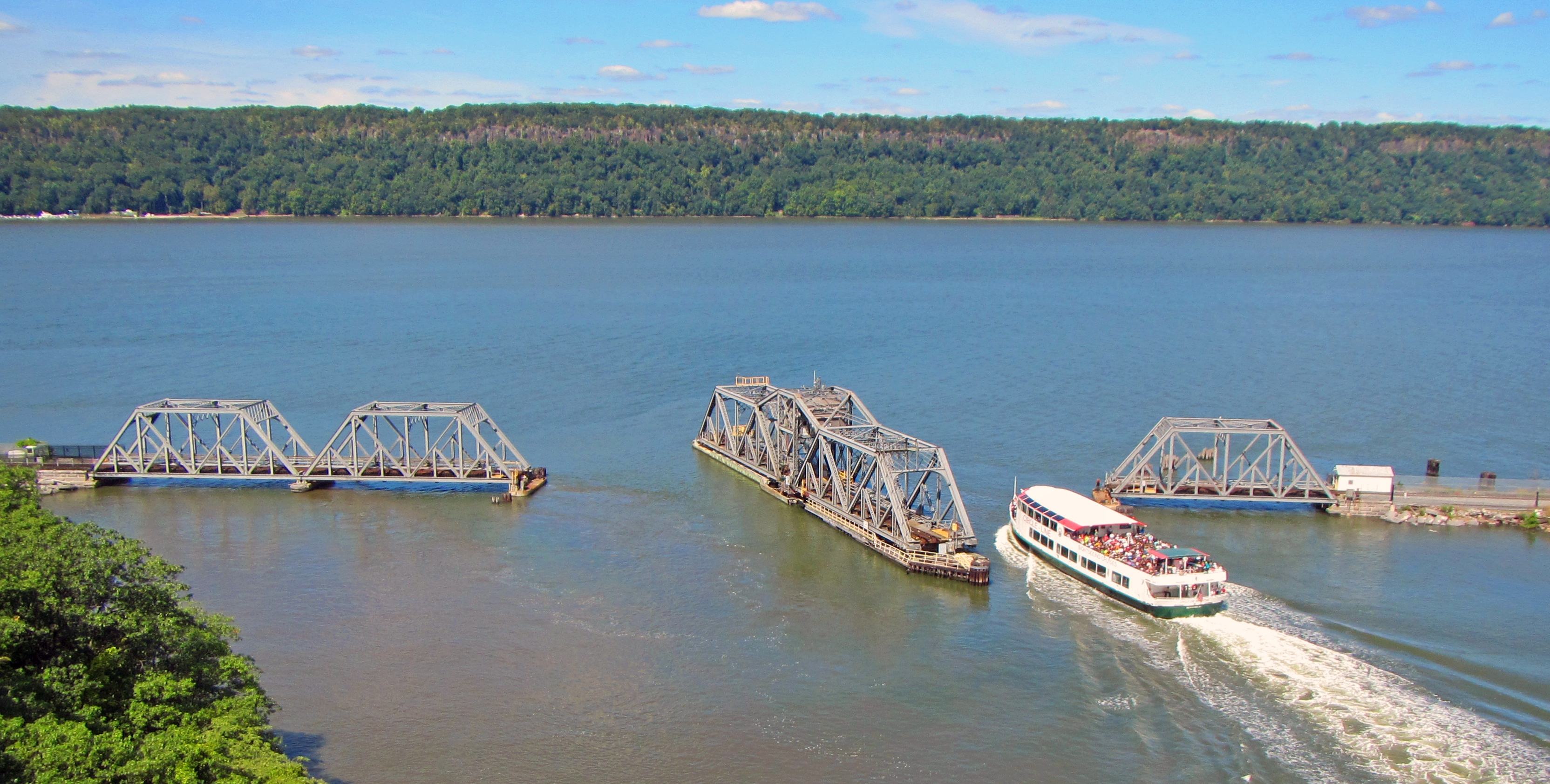
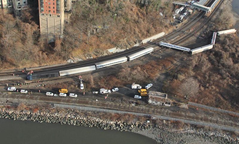
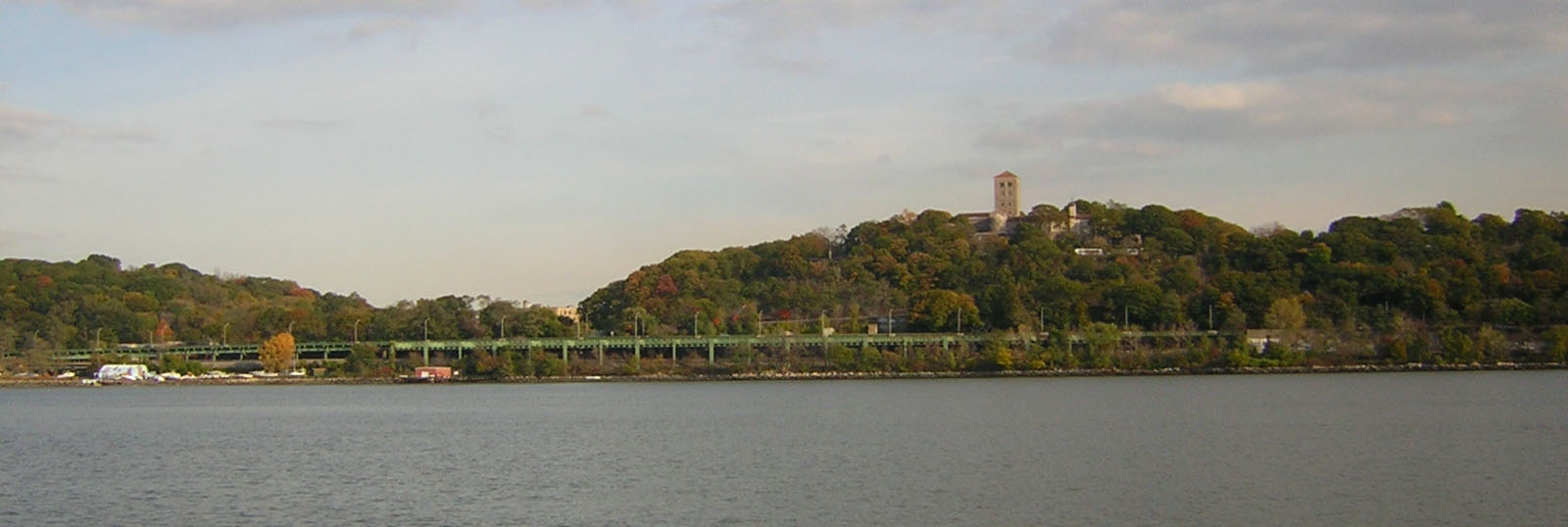
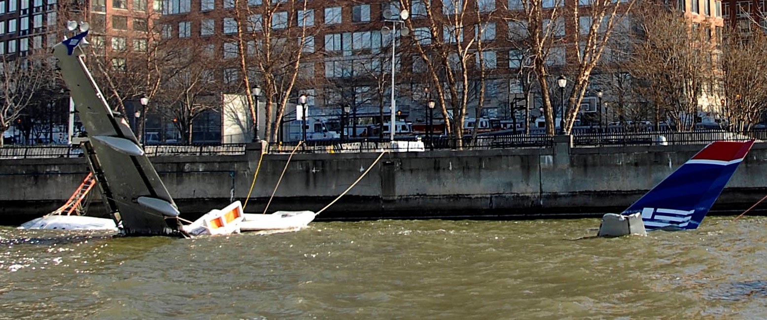
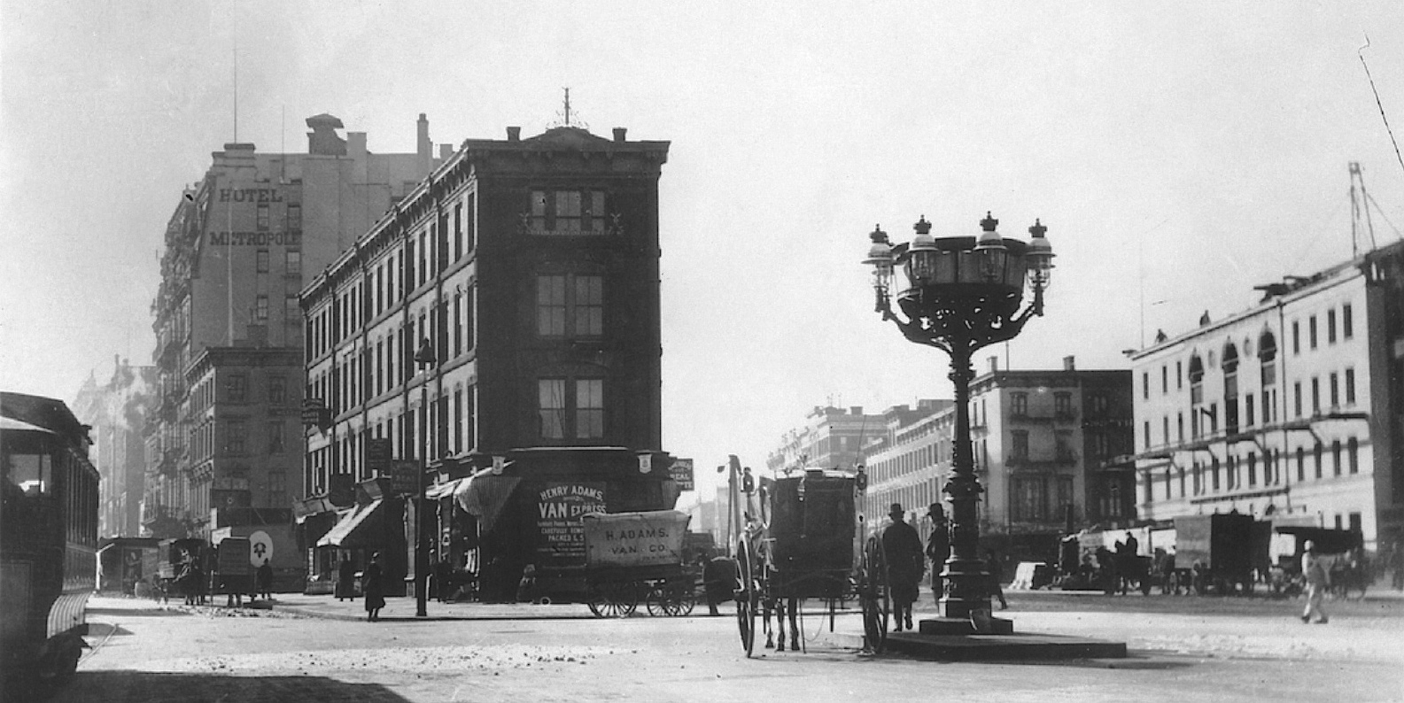
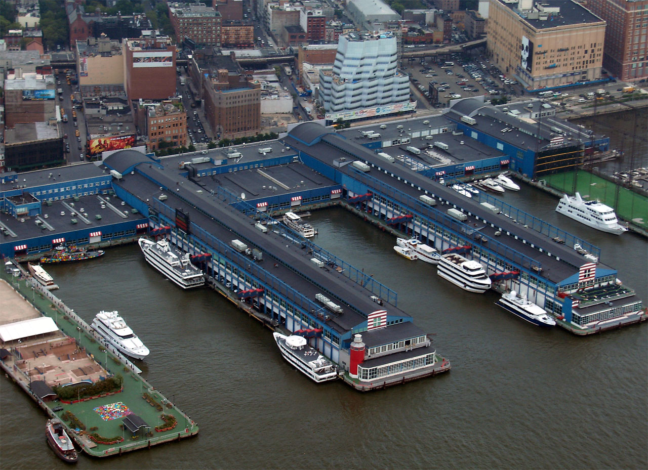
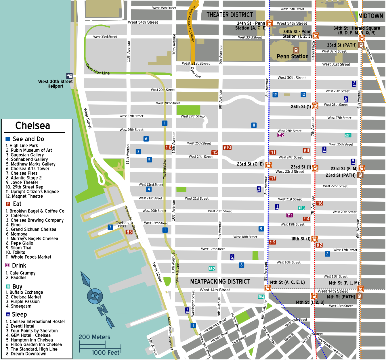
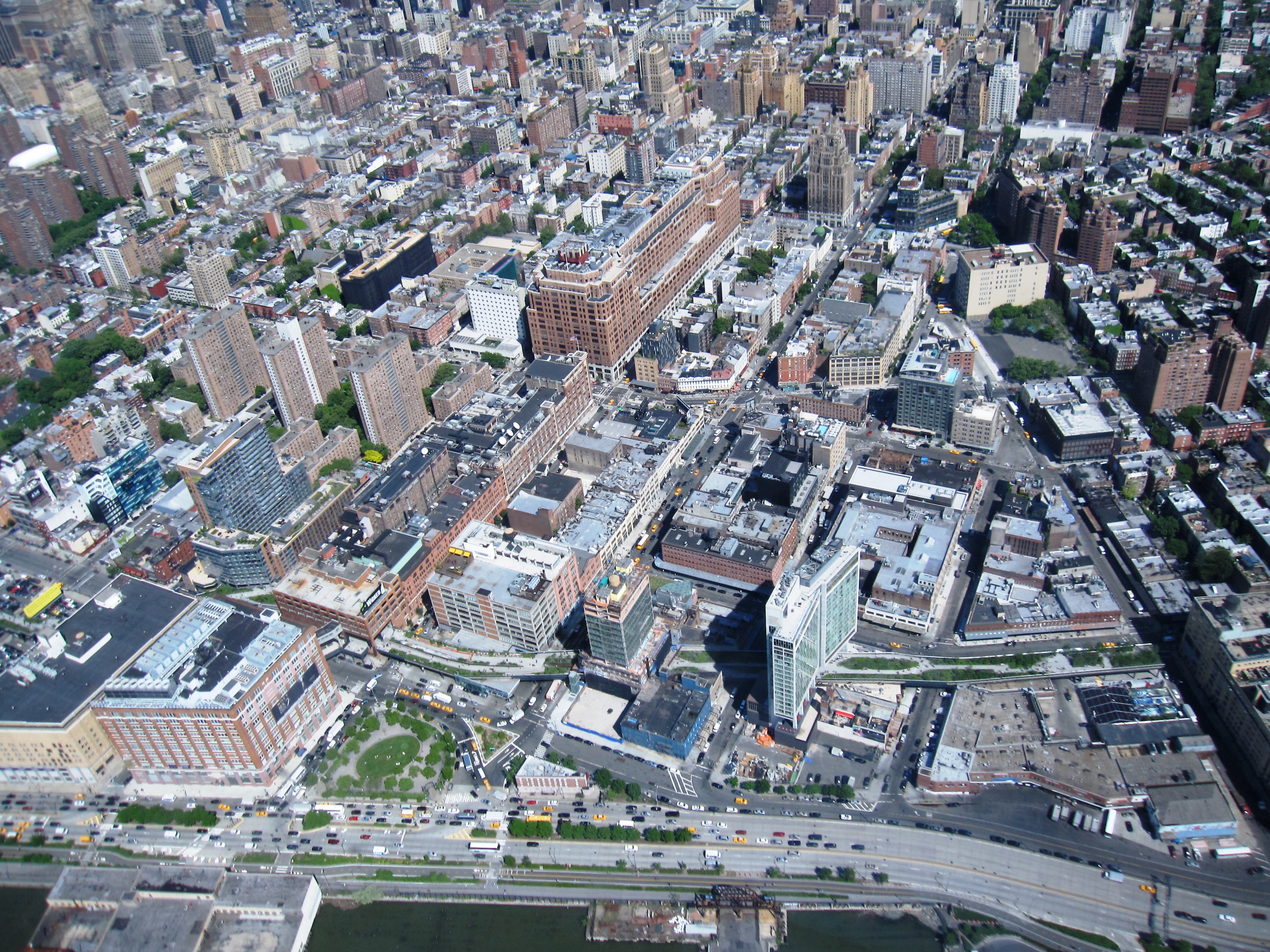
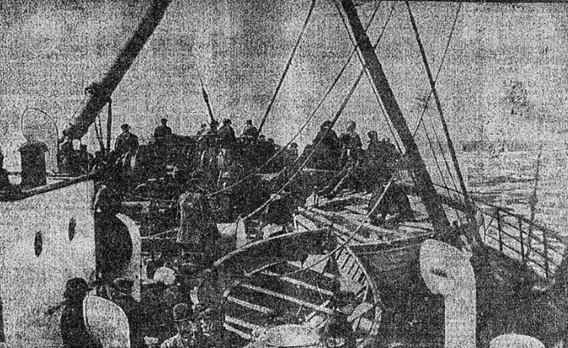
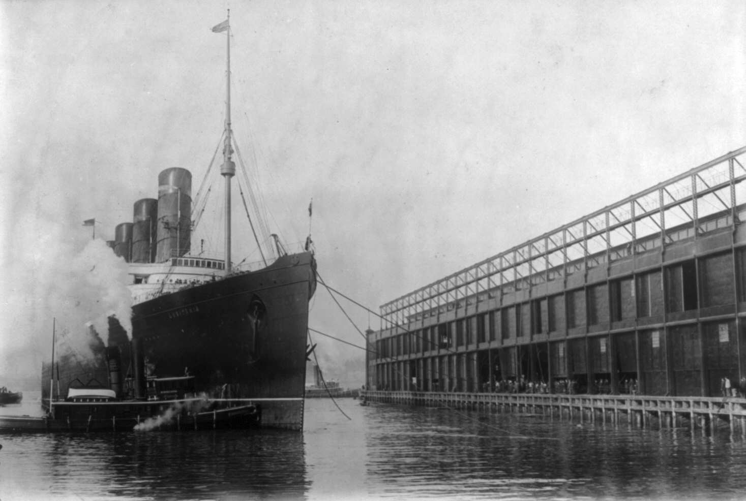
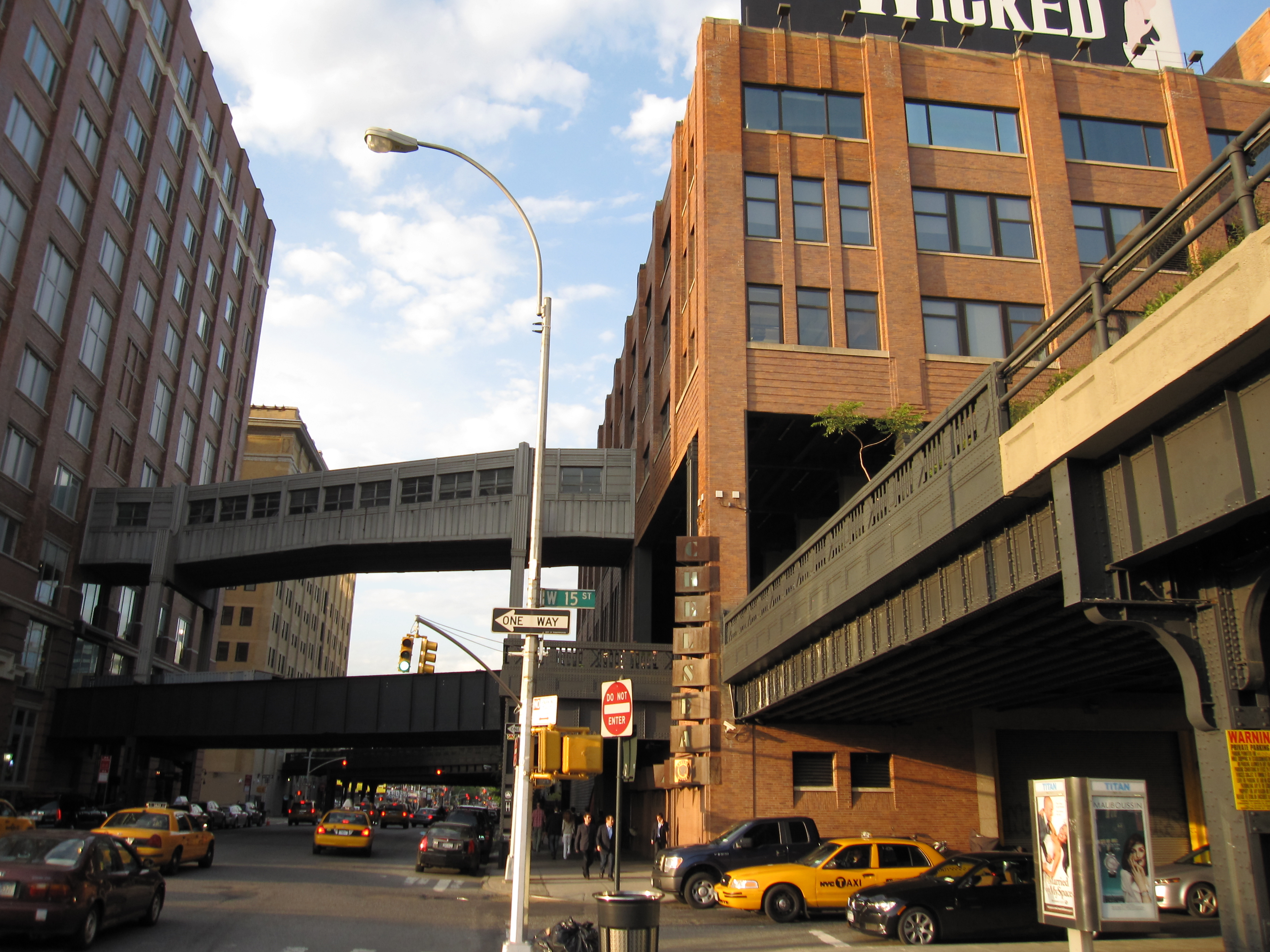
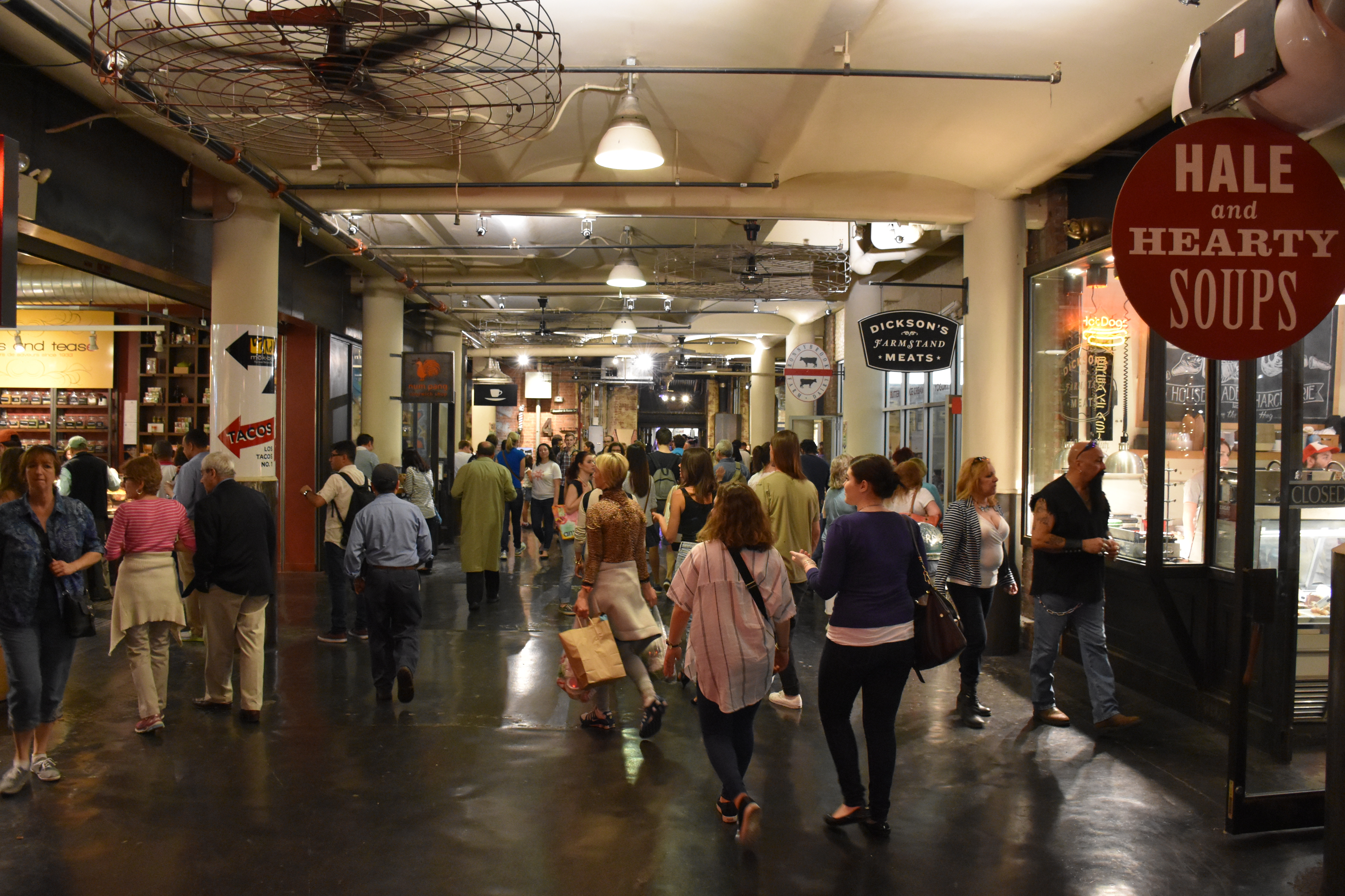
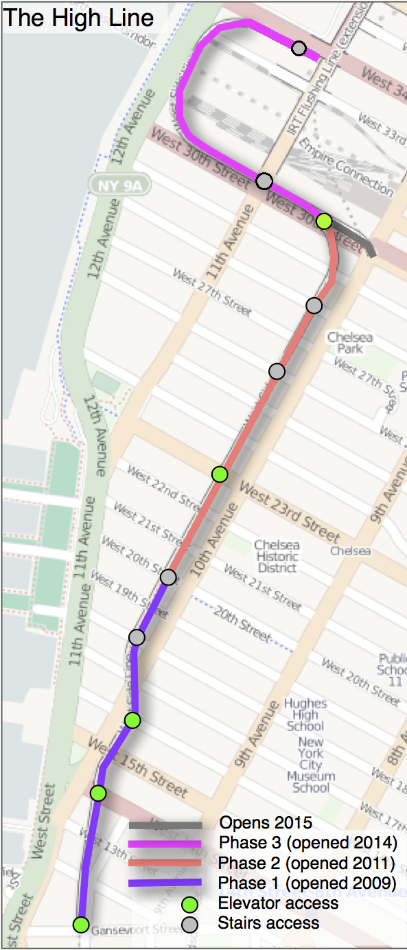
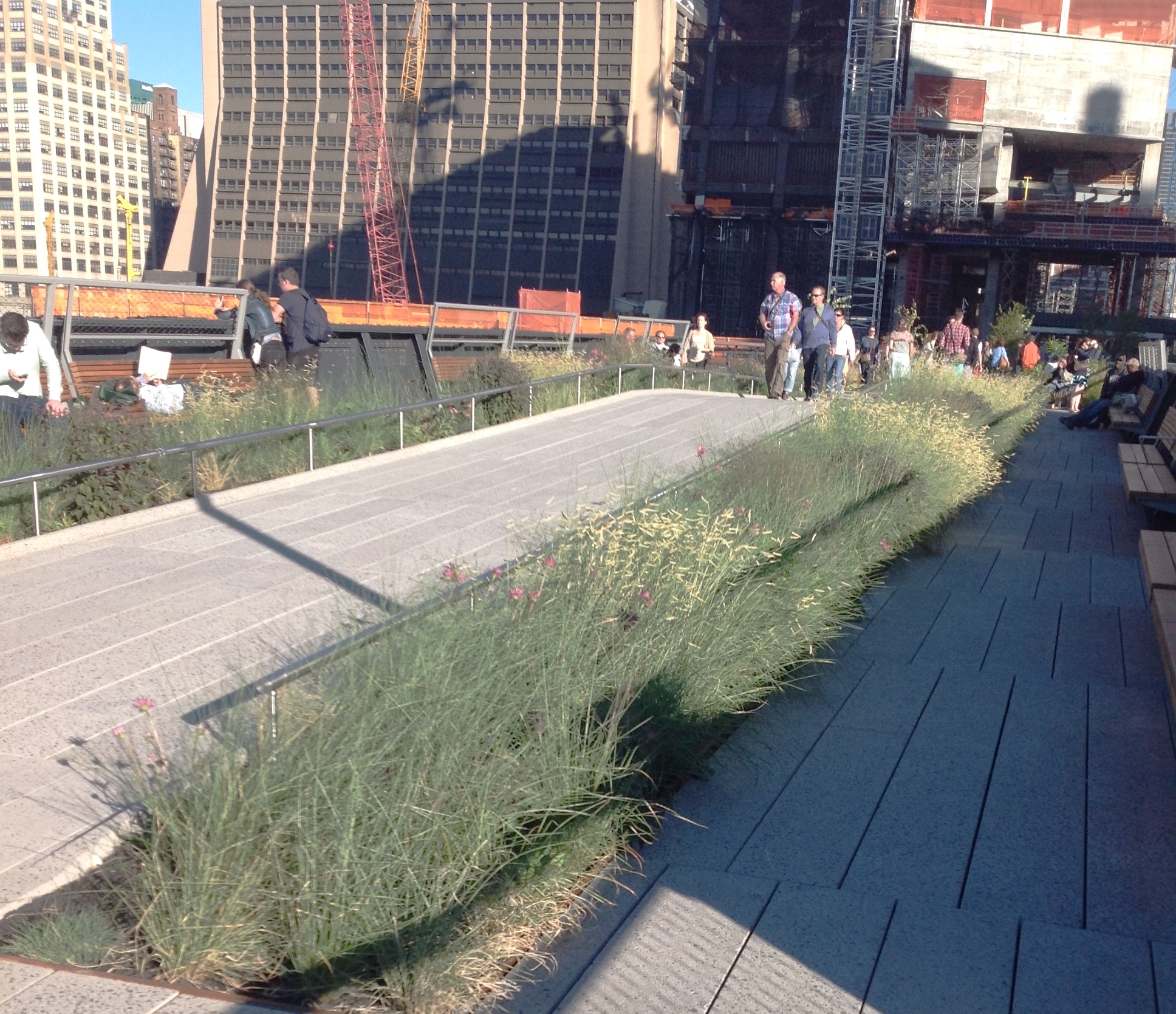