|
Reflections 2019
Series 8
June 30
Promontory & Gold Spike 150th Anniversary - Transcontinental Rail Routes
| | Rationale Over time I've quoted friends when I felt they had something great to add to a posting. Most frequently it would be a short quote within a text, but sometimes it was more. When Carter Brey said he'd written an article about North Korea for an Italian magazine, but had no publisher for it in English, I said I'd be glad to do it as a posting if he wished, which resulted in 2008/5. That was the only time that an entire posting was turned over to a guest essayist. More recently, when Terry Johnston emailed me about his trip to see the solar eclipse, I asked him if I could publish his description of it, which then appeared within 2017/17 after an introduction by me. | | | | Last month, David Irish told me he was fulfilling a long-time dream of going to the Sesquicentennial of the driving of the Gold Spike in Utah in 1869 at the meeting of two railroads. I asked him to keep me updated by email during the trip, and when it was over, I asked him if he'd put an piece together for me to publish within a posting. He wrote a great piece using his travel diary notes, which is now part of this posting on the subject, which I prefaced with background, and followed with some further thoughts and a discussion of transcontinental routes. | | | | There are parallels between Terry's and Dave's adventures. (1) Terry has the passion for astronomy of an expert. Dave has the passion for rail and rail history of an expert (I too have that passion, but he does more so). (2) In 2017, Terry traveled from Florida across most of the US to Wyoming to experience the eclipse. Last month, Dave traveled from NYC across most of the US to Utah to visit the historic site and to attend the ceremonies. On the other hand, (3) I felt I had to add background to what Terry was saying, and to do so, had to brush up on my astronomy. And so now, even though Dave wrote for a general audience, I still felt I had to add background to what Dave was saying and I had to brush up on my rail history as to details of just what happened in Utah a century and a half ago. | | | | | | But let's start with an aside. The other event that comes to mind similar to the Gold Spike meeting of the two railroads in 1869 is another transportation event, the ceremony at the opening of the Erie Canal in New York in 1825. It was only 44 years earlier, but SO different an era. Yet it was as important in its day to the development of water transportation reaching from the Atlantic to the Great Lakes as the Gold Spike was to the successor of water transportation--rail transportation--reaching from the Atlantic to the Pacific. When the entire Erie Canal was officially completed on 26 October 1825, the event was marked by a 90-minute cannonade from Buffalo to NYC, cannon shots along the length of the canal and the Hudson. A group of boats led by Governor Dewitt Clinton sailed from Buffalo to NYC over ten (!) days. Clinton then ceremonially poured a keg of Lake Erie water into New York Harbor. When his boat returned to Buffalo, another official poured a keg of Atlantic Ocean water into Lake Erie. These events were meant to mark the "Wedding of the Waters". The Gold Spike ceremony was perhaps even more important to its era. Perhaps it can be called the "Wedding of the Rails". [Just kidding.] |
| | | | Though I'm not bad at rail history, the Utah event was fuzzy in my mind. Just where in Utah did it happen? What's the difference between Promontory, Promontory Summit, and Promontory Point? And what's so prominent about any of them? Why do people misunderstand and say they "built" a monolith called "the" Transcontinental Railroad? And why do no trains run along that part of the original route anymore?
https://onlineutah.us/images/promontorymap4.jpg
| | | | Geographic Background Let's first take a look at Utah, above. I've traveled to several National Parks in southern Utah (2007/14), and years before that, Beverly and I visited Salt Lake City, leaving it by driving west and along the south shore of Great Salt Lake (see map). I've also taken Amtrak's California Zephyr along that south shore. But the map shows Promontory as being well to the north of the Lake, with a long, thin peninsula running south from it, opposite Ogden and Brigham City, and I have no first-hand experience with that area. | | | | | | Also, look for something that isn't there. (!) Over the state line into Nevada, you see the letters –llo. This is Montello NV. To the northeast of Montello, on the Utah side, is the tiny town of Lucin (not shown), located quite some distance west of the Lake. Remember Lucin for later. |
| | | | Anyway, not having any first-hand experience, this is what I've recently learned.
http://ontheworldmap.com/usa/lake/great-salt-lake/large-detailed-map-of-great-salt-lake-max.jpg
| | | | Here's a detail of just the Great Salt Lake (click). Since we're just talking geography here, we won't necessarily explain the history yet. In the lower right is Salt Lake City, and both the Interstate and rail line running west along the south shore of the Lake are shown. Center right you can barely read that that’s Ogden, and above that, Brigham City. But in the upper center we find what we're looking for. | | | | We now see that it's the Promontory Mountains that run north-south for about 56 km (35 mi). They're the "prominent" feature that gives substance to the other names based on the name of these mountains, and it's their southern end that extends for 32 km (20 mi) into the Lake, forming a cape, logically called Promontory Point. | | | | The original rail route, whose east and west sections were joined here in 1869, as it came from Omaha NE, went from Ogden over the Promontory Mountains further to the north, at a former town called Promontory at the Promontory Summit, located 51 km (32 mi) west of Brigham City, and at a height of 1,494 m (4,902 ft). It was here that the two rail lines originally met and the Gold Spike ceremony was performed. The original route then swept south to that fishhook shape—only this much is part of the Golden Spike National Historic [Site, now] Park. The route actually swung northwest again and around the north shore of the Lake and on to California. | | | | But we see another route here. Since the Great Salt Lake is quite shallow, with an average depth of only 4.9 m (16 ft), in 1904, a rail line was built on a causeway across from Ogden to Promontory Point, then along the Point a short distance to Saline, then on to the west shore. This western segment consisted of a short causeway at each end and a trestle for most of the center. In 1959, the two short causeways were connected, and later the trestle removed, which accounts for the irregular line of the western causeway. This whole causeway system via Promontory Point is called the Lucin Cutoff, since it joined the original route at the town of Lucin (see above), well off this map to the left. The Lucin Cutoff has an elevation of 1,310 m (4,297 ft). | | | | But this is primarily geographic and tells little about why there are two routes. How does all this tie together? Why were two different railroads meeting here, anyway? And why here, and not well further north or south? Therein, as usual, lies a tale. | | | | Terminology One term was—and still is--thrown around about this rail project willy-nilly: Transcontinental Railroad, which, though somewhat accurate, implies a number of inaccuracies. Let's leave that term for a while. | | | | A term used at the time was quite of the era: Overland Railroad. Back in the day, it indicated that rail could now get people coast-to-coast without having to sail around Cape Horn at the bottom of South America, or to sail to pre-canal Panama for a crossing of the malaria-infested isthmus by coach to a second ship on the other side to complete the journey. This newly planned rail route avoided the sea entirely by being, as the name says, Overland, and creates an understandable period image. But it's not a useful term anymore. | | | | A third term used at the time I find to be the most accurate, for then and for now, and I'll continue to use it: Pacific Railroad. That's precisely what was being built, despite all of the hyperbole added to the topic by calling it a Transcontinental Railroad. There already was a myriad of railroads in the East, many of which connected to the Atlantic. This new project was meant to connect to the Pacific, as indicated by the use of that word in the names of the railroads in competition to build this and other routes, such as the Northern Pacific, Central Pacific, Union Pacific, Southern Pacific, and Kansas Pacific. | | | | Pacific Railroad Interest had been building on bringing rail from the East to the Pacific—a "Pacific Railroad"--since the 1840s, and the government sponsored expeditions looking for potential routes. But the rival rail companies were selfish and wanted as much of the pie as they could get. In addition, states competed to have the route through their territory and cities competed to be the eastern terminus. Thus, no consensus could be reached. | | | | Between 1853 and 1855, the Pacific Railroad Surveys were compiled to determine the most favorable route and were published by the US War Department between 1855 and 1860, just before the Civil War.
https://geology.com/world/the-united-states-of-america-map.gif
Use this map of the US to judge where the routes might have been (the red lines show roads, not rails, but nevertheless suggest the connectivity between cities). Possible routes explored were:
A Northern Pacific route from Saint Paul MN to the Puget Sound (Washington was not yet a state, nor was Seattle yet a city).
A Central Pacific route from Saint Louis MO to San Francisco CA.
One Southern Pacific route from Oklahoma to San Francisco CA.
Another Southern Pacific route across Texas to San Diego CA.
| | | | Since the Mississippi River is usually considered the north-south dividing line of the US, it's of interest to note that the suggested northern and central starting points were Saint Paul and Saint Louis, both on the Mississippi. But there were already rails west of those places, and we'll see in a moment that the Missouri River was instead substituted as starting points for the suggested Northern and Central routes. | | | | As for the Northern Pacific route, presumably Saint Paul would have received rail traffic from Chicago. This was not the chosen route, discounted for fear of snow problems, but was later built anyway, and today, as for passenger trains (which interest me in particular) it's the route of Amtrak's Empire Builder from Chicago via Saint Paul to Seattle (and Portland). | | | | The secession of the South as the Civil War started discounted any influence of the South in promoting the two southern routes. While the Southern Pacific via Oklahoma/SF route was perhaps the least viable of all four, at least part of it was eventually built (involving neither Oklahoma nor San Francisco), and as for passenger trains, Amtrak's Southwest Chief from Chicago to Los Angeles covers that route's western stretch through New Mexico, Arizona, and southern California. | | | | As for the proposed Southern Pacific via Texas/San Diego route, that also languished, but was eventually also built in modified form, and is today the route of Amtrak's Sunset Limited from New Orleans to Los Angeles--not San Diego. (The Florida connection of the Sunset Limited is presently suspended due to hurricane damage.) | | | | So it came down to the Central Pacific route from Saint Louis to San Francisco, but a modified one. If it wasn't going to start in Saint Louis, since rails already reached beyond that to the Missouri River, where would it start? Kansas City MO lines up nicely with feeder rail lines from Saint Louis, and leads through Kansas to Denver, Salt Lake City, and San Francisco. On the other hand, Omaha NE lines up nicely with feeder rail lines from Chicago, and leads through Nebraska to Salt Lake City and San Francisco. Which one would you choose? This is one place where, as the plot thickens, the rivalry between two states, two cities, and two railroads really bubbles up. | | | | In 1862, Congress passed the Pacific Railway Act (note "Pacific" in the name, not "transcontinental"). It had come out in favor of Nebraska, and specifically of Omaha, which President Lincoln had chosen for the Transfer Depot where up to seven railroads could transfer mail and other goods to Union Pacific trains bound for the west. But to get the construction job done faster, it chose two railroads, the Union Pacific and Central Pacific (again, note "Pacific") to build continuous railroad and telegraph (interesting!) lines in opposite directions. But, since the devil is in the details, note what their specific mandates were to connect "Omaha" (but not quite) with "San Francisco" (but not quite). | | | | The Union Pacific would build west from the eastern shore of the Missouri at Council Bluffs, Iowa. However, Omaha NE is on the western shore of the river, opposite Council Bluffs, so we already have a challenge. | | | | The Central Pacific would build east from the navigable waters of the Sacramento River in Sacramento CA. This is another challenge. While Sacramento is in California, it isn't on the coast, and more importantly, it isn't San Francisco. | | | | Finally, after laying a combined 2,855 km (1,774 mi) of track, the two rail lines joined on 10 May 1869 at Promontory Summit (that original route running over the mountains), and had the ceremonial driving of the Gold Spike to commemorate the event (Photo by Americasroof). Actually, this picture shows only one of four precious-metal ceremonial spikes that appeared at the original ceremony. Two were of gold, one of gold and silver, and one of silver. And not one of them was actually driven into a tie "to complete the job", or even received a love tap, and for good reason. The gold spike was made of 17.6-carat gold, which is much too soft to have survived any blow from a spike maul. | | | | This is the Gold Spike ceremony that appears in the history books, and whose sesquicentennial Dave attended on 10 May 2019. This famous photograph by Andrew J Russell is called "East and West Shaking Hands at Laying Last Rail". At center left, the representative the Central Pacific shakes hands with the representative of the Union Pacific, center right. I read somewhere that some versions of this picture were sanitized by obliterating the bottles in the "liquor salute" at the top center, leaving the two workers empty handed with their arms suspended in midair. If it's not quite accurate, it still makes a good story. | | | | | | We come across two variations of the same word here. I've always heard Golden Spike, and the Historic Park uses that term, but Dave and other sources use Gold Spike. We need to make a decision. It's an odd—and relatively rare—suffix in English, -EN added to materials to mean "made from". The few words that come to mind are: silken, leaden, oaken, wooden, golden. Actually that suffix is not only becoming rarer, it's fundamentally useless. Every one of those words would work just as well without it. My analysis is that the suffix –EN makes the substance figurative, and not real, even perhaps a bit poetic.
One speaks of a silk scarf, but can poetically speak of silken hair.
One speaks of a lead pipe, but when sleepy, can poetically speak of leaden eyelids.
One speaks of oak furniture or floors, but the folksong deals with "the old oaken bucket".
One speaks of laying a wood floor, but in the kitchen the term "wooden spoon" remains with us.
One speaks of a gold ring, but a blond person can be said to have golden hair.
[The only word in –EN that seems useful is "earthen". One would normally speak of an earthen dam--calling it an "earth dam" sounds awkward, and I can't think of any figurative use.]
For instance, a silk scarf is really made of silk, while silken hair is just (smooth) hair. So would you come down in favor of "Gold Spike" or "Golden Spike"? I agree with Dave and other sources. Let King Midas have the Golden Touch. At Promontory Summit we'll be talking about the Gold Spike, since it was really made of gold and is not used figuratively.
|
| | | | It was a momentous event in American history, in rail history, and, as Dave found out for us, in Utah history. I'm also delighted that Dave finally got to make his way to the ceremony at the very same site a century and a half after the event. However, the historic event is purely symbolic, indicating the joining of the two parts of the US and the role of railroads in doing it. But since the devil continues to remain in the details, we have to take that momentous event with a tiny grain of salt. But we'll get back to that. First, let's complete the story.
http://pittsfieldhigh.pittsfield.net/UserFiles/Servers/Server_1057139/File/USII%20Railroads/transcontinental_rr_map_1.png
https://image.slidesharecdn.com/railroadpres-091208001905-phpapp02/95/railroad-lesson-14-728.jpg?cb=1260231594
| | | | The first map is helpful in being able to visualize the maze of trackage already existing in the East, plus the sections the two railroads were adding in the West. The error on the map is in saying it happened at Promontory Point (which was a later event), not Promontory Summit. It also plays with the word "transcontinental", implying some unity. The second map is clearer, does mention the Summit, but doesn't show the East, so we present them both. | | | | The Union Pacific built 1,746 km (1,085 mi) of track westward from Omaha (not Council Bluffs—the first glitch) to Promontory Summit.
The Central Pacific built 1,110 km (690 mi) eastward from Sacramento (not San Francisco—the second glitch) to Promontory Summit.
[Note for later comment that hook-like connection built later beyond Sacramento.]
| | | | But as it turned out, Promontory Summit was an impractical place for two railroads to meet, since it was literally in the middle of nowhere—and up in the mountains to boot. While its significance remains symbolic as the location of the joining of two parts of the Pacific Railroad, it quickly lost any other specific practical value. To find a more practical meeting place for the two railroads building the line, the Central Pacific purchased from the Union Pacific 85 km (53 mi) of right-of-way and track that the UP had laid between Promontory Summit back to Ogden, thereby making Ogden's Union Station the sensible interchange point between trains of the two railroads. Eight months after the Gold Spike, in January 1870, the train crews of both the CP and UP relocated to Ogden. So while Promontory Summit remained an important location historically, it was virtually abandoned, and its importance began to decline, though the route through it remained in use for some time. | | | | However, Union Pacific engineers from the very beginning had considered a direct route cutting across the Great Salt Lake, but costs and scheduling forced them to build instead over Promontory Summit. But then the trains coming through became longer and heavier, and additional engines were often needed to pull the trains along the winding curves and steep grades to get over the mountain. In time, the original cross-lake idea looked better and better.
https://c2.staticflickr.com/6/5008/5222794733_2ba623599e_b.jpg
| | | | Lucin Cutoff We now come to the point where the local route was shifted, as we saw earlier while reviewing the geography. The change is shown clearly in the above map, and was effected by the Southern Pacific Railroad, which had acquired Central Pacific operations in 1885. In blue is the original 1869 route out of Ogden, passing Brigham and crossing the mountain at the temporary hamlet of Promontory, then continuing to rejoin the main line just beyond Lucin at Umbria Junction. We see the new Lucin Cutoff route, built between 1902 and 1904, leaving the old route just beyond Ogden at Cecil Junction, then crossing water twice with Promontory Point in between, then continuing on to Lucin and Umbria Junction. The cutoff runs through relatively shallow waters for 164 km (102 mi) and not only reduced the original route by 71 km (44 mi), it significantly decreased curvature and grades. While much of it was a causeway, the main part of the western section was a 19 km (12 mi)-long wooden trestle, more clearly seen here (Map by Beneathtimp). The trestle was in use from 1904 until 1959, when it was replaced by an adjacent rock-and-dirt causeway, making the entire route over water all causeway now. The new causeway was built just to the north of the trestle so as not to interrupt service. The trestle remained in limited use as a backup into the 1960s, but by the 1980s, its condition had so seriously deteriorated that in 1993, the timber was salvaged and removed. This dizzying, but spectacular aerial picture (Photo Credit: Library of Congress, Prints & Photographs Division, UT-13-5) shows the trestle before removal looking to the west. Its replacement causeway can be seen in the upper right, including where it (click) rejoins the older route. The trestle was formerly listed on the National Register of Historic Places, and I find using the need to use the word "formerly" a bit jolting.
| | | | The last regularly scheduled long-distance passenger train to pass through Promontory station was on Sunday, 18 September 1904. By 1908, five passenger trains and seven freight trains were using the Lucin Cutoff in each direction daily. After the Depression caused a dramatic fall in railroad revenues, the Southern Pacific decided to abandon the original line over the mountains entirely when it failed to meet its operating costs. But it was during WWII that the greatest indignity came to the original Promontory route. In 1942, the entire original route was torn up and the rails became scrap metal donated to the war effort. | | | | Today, freight trains continue to use the Lucin Cutoff over both causeways connecting across Promontory Point at the southern tip of the range. As noted earlier, Amtrak passenger trains run along the south shore of the Great Salt Lake. Sic transit gloria mundi. | | | | Modern Times But the historic location was not forgotten, not across the US, and particularly not in Utah, where it's a point of historic pride. Should there be any doubt about that, then take note of the fact that, when states were deciding what image should represent them on their state quarter when it was issued in sequence of statehood, Utah chose in 2007 the meeting of the railroads and the driving of the Gold Spike. This reverse side of the quarter shows the date of Utah's statehood, 1896, and the Gold Spike between the CP#60/Jupiter and the UP#119. The sensible caption was Crossroads of the West, and properly said nothing about any transcontinental railroad. | | | | | | While on the subject of transportation and joining together parts of the US, it's worth pointing out that New York's state quarter illustrated the Erie Canal story we mentioned, just as Utah's did the Gold Spike. Along with the date New York ratified the Constitution, 1788, and the caption "Gateway to Freedom" referring to the Statue of Liberty, the map of the state clearly shows the Erie Canal as well as the Lower Hudson River that extended its route. |
| | | | National Historical Park Given the historic location's epic importance—symbolically—in the history of the US, there was a concerted effort to save it. In 1957, local campaigners succeeded in getting the federal government to recognize the area as a National Historic Site, though without federal ownership of the land. The Southern Pacific still owned the right of way, denuded as it now was, but agreed to turn its holdings over to federal management. In 1965, the act was signed into law forming the Golden [sic] Spike National Historic Site under federal ownership and administration. Just this year, on 12 March 2019, two months before its Sesquicentennial (150th Anniversary) Celebration, it was re-designated as a National Historical Park. Historic sites are usually a single building, while historical parks are larger, and include multiple landmarks.
| | | | If you refer back to our map of the Great Salt Lake, you can see how the park fits in. That map shows a larger east-west park area in gold, with a separate area in gold reached by a side road. Beyond that, it shows a fishhook shape sweeping down to the southwest. Keep that in mind when you look at this map of the NHP, which is shown at a twisted angle:
http://www.mappery.com/maps/Golden-Spike-National-Monument-Map.jpg
| | | | There's at least one thing I was unaware of until I read Dave's piece (below), that the two railroads didn't just build up to the point where they met so dramatically in the photograph. This map from the Park Service also shows that they built right past each other, resulting in parallel routes! As is stated on the right, the grades of the two railroads crossed each other several times, and occasionally, they used the same grade. It would seem that the Gold Spike site is one place where they used the same grade (check that out on the map), and so it was decided that that would be the location of the official and symbolic joining of the rails, though the rails already came together at this point for dual use! | | | | I suppose it shouldn't be surprising that the railroads kept building past each other. Human greed would explain each one grabbing as much land as possible, theoretically ending up possibly with two parallel routes end-to-end belonging to two parallel railroads! As Dave points out, it was Congress that had to step in to cut back on such nonsense (my term), to stop further parallel construction, and to arbitrarily find a common meeting point. | | | | With this understanding, still realizing that the Gold Spike ceremony was of great symbolic importance, we have to admit that it was an early example of a staged media event. As thrilling as the image of two locomotives facing each other on a piece of track may be, since such a thing could never really happen, it's clearly an example of exaggerated media hype, just as the use of a gold spike was. But on the other hand, it's just that sort of hype that gets the event into the history books. | | | | Big Fill/Big Trestle Since the Park, by definition, includes multiple landmarks, we can comment on three, all located in the larger park area on the right. Let's virtually locate ourselves on the map at the Big Fill/Big Trestle Viewpoint on the Scenic Drive. Closest to us is the Big Trestle Site (it's gone now) on the UP route, and just beyond that is the Big Fill on the CP route. | | | | As the two railroads were laying track alongside each other (!!!), one particular engineering problem arose for both of them, how to cross a deep ravine on the eastern slopes of the Promontory Mountains. Central Pacific engineers, wanting to avoid boring a costly 240 m (800 ft) tunnel through mountainous terrain, came up with an alternate solution that brought them to this ravine. In February 1869, three months before the Gold Spike, they began construction of a raised bed across the ravine, sort of an overland causeway. Over two months, 500 workers hauled material to fill in a route across the ravine on top of which they laid the rail bed. The so-called Big Fill extended for 150 m (500 ft) and had a depth of up to 21 m (70 ft). Though I've only seen it in pictures, this is what remains today of the (trackless) Big Fill as it runs across the ravine (Photo by Chris Light). | | | | It's amazing that the two railroads were duplicating their efforts here, but the Union Pacific was also attempting to cross the ravine, and within site of the Big Fill! The UP was several months behind the CP, and their engineers decided to build a wooden trestle instead of using earthen fill. The Big Trestle, the last major bridge before the Gold Spike site, was built in 36 days and was completed only five days before the Gold Spike. But a few months later, once the CP got control of the line from Promontory to Ogden Union Station, given this incomprehensible duplication of effort, they decided to unify the route. They opted in favor of their own Big Fill route and removed the rails from the poor quality Big Trestle. The Big Fill route remained in use until all rails here were removed in 1942. | | | | We found a very cleverly taken panoramic photo of both these sites, which is also nicely annotated (Photo by Chris Light). First click on the white legend at the bottom for the color code. Then look for the two purple boxes at either end showing the original abutments of the Big Trestle, along with the purple horizontal lines showing where the track had been. Then look just beyond and you're seeing the Big Fill, with green horizontal lines showing where the track had been. | | | | Chinese Arch The third thing of note on the right of our map, the Chinese Arch, is of geological importance, but I find it reveals just as much about sociology. Geology first: Ancient Lake Bonneville (Map by Fallschirmjäger) had once covered this entire area—this is what the area looked like about 17,500 years ago. It lasted until the Bonneville Flood of about 14,500 years ago, at which time a large portion of the lake was released via the Pacific Northwest (see red arrows) down the Snake and Columbia Rivers. Following the Bonneville Flood, the lake receded, with the Great Salt Lake being the most obvious remnant.
| | | | Waves of Lake Bonneville would hit the shore and erode the rocks, which is how the limestone Chinese Arch was formed. It's larger than one might think, 6 m (20 ft)—compare it to the size of a person (Both Photos by Chris Light).
| | | | That's the geological side of it, but most interesting is the naming of it. At the time of the Gold Spike, it was named the Chinaman's Arch to honor the 19C Chinese railroad workers. That paternalistic term might have been typical for its day, but it rubbed modern sensibilities wrong. In 2006, a petition for a name adjustment went to the US Board on Geographic Names (remember our discussion on the Board's opinion to change place names in –GH to -G and to drop apostrophes in place names). That same year, the arch was officially renamed the Chinese Arch, which is a more respectful way to honor the workers. | | | | Replicas The Gold Spike ceremony has been such a major part of American history that, even though the two original engines were long ago scrapped, several replicas have been made over the years. In the case of the NHP, two purpose-built replicas were brought together on the 110th Anniversary of the Gold Spike on 10 May 1979. They're exhibited on a specially relaid 2.4 km (1.5 mi) section of track next to a purpose-built engine house for storage (see map). There are walking trails—which I know Dave took advantage of—that allow visitors to see the old cuts, now trackless, along the route. While the park is open throughout the year, it's only on Saturdays and holidays during the summer season that the two replica locomotives are lined up to re-enact the Gold Spike ceremony. | | | | This is the replica of Union Pacific's steam locomotive, the UP#119 that came in from the east. Click to inspect the magnificent detail of its construction, including its bell, headlight, and slender smokestack. Its number appears twice on its livery. This is the replica of the Central Pacific's steam locomotive, the CP#60/Jupiter (Both Photos by Mr Snrub), which notably used the name Jupiter in addition to its numeric name. Click to inspect the spectacularly wide funnel of its iconic smokestack, as well as its bell, headlight, and names on its livery. | | | | Now look again at the historic photograph and compare it with a modern re-enactment of the meeting of engines (click), complete with steam, smoke, and workers in the cabs. | | | | A Visit to the 150th We should now have sufficient background to understand what Dave traveled to experience early last month, between the 8th and 12th of May, which he described as a Fantastic Trip.
| | | | David Irish: For many railroad enthusiasts, May 10, 1869 holds special significance--the date when the rails of the Central Pacific and the Union Pacific joined together at Promontory Summit in Utah Territory. It was the "moon shot" of its day, 100 years prior to the Apollo 11 lunar landing. When it was completed, it shortened the journey between the east and west coasts of the US from at least two months to 10 days. It completely changed the growth trajectory of this country and accelerated westward migration. Like most events, this had both positive and negative effects, but the country could never go back.
| | | | I distinctly remember the 100th anniversary of the Gold Spike when I was 13 years old. At the time, I was a budding rail buff and any flanged wheel on a steel rail captivated me. As time progressed, I turned my hobby into a vocation, working for Amtrak for over 37 years before retiring in January 2018. Over time, I was bound and determined not to miss the 150th anniversary and that desire only increased in the last few years. Knowing that this would be a popular event, I booked my flight, hotel, and rental car arrangements back in September 2018. | | | | Another notable backdrop to this event was the resurrection of one of the Union Pacific’s "Big Boy" steam locomotives. The 25 Big Boys were arguably the largest steam locomotives ever built, with a 4-8-8-4 wheel arrangement and designed to run primarily between Cheyenne and Ogden on the UP mainline. After being on display in Pomona CA, the Southern Chapter of the Railway & Locomotive Society agreed to transfer Big Boy #4014 back to the Union Pacific, and three years ago, rebuilding efforts began in preparation for the 150th anniversary celebration of the completion of the transcontinental railroad. | | | | I flew to Salt Lake City on Wednesday, May 8, picked up my rental car, and immediately headed 30 miles [48 km] north to Ogden so I could get the lay of the land. The Big Boy and [its] sister #844 (4-8-4) had arrived with the Union Pacific special passenger train earlier in the day, so I had a good look at the train in the Ogden Union Station--minus any steam power—since the Big Boy and #844 were being inspected in the shop after hauling the train from Cheyenne WY. It was relatively quiet and I was able to get a glimpse inside the UP display car before everything was shut down for the day. The peace and quiet was deceiving--crowds would inundate the scene over the next few days. | | | | I had reserved a room in the Hampton Inn in Brigham City north of Ogden and only 25 miles [40 km] east of Promontory Summit. When I was planning this trip it seemed like a logical place to encamp, but I should have suspected that there would be many events in the Salt Lake City and Ogden area to commemorate the events of 1869. After checking the "Utah 150" website, I decided to drive back down to Salt Lake City on May 9 to visit the State Capitol Building where the gold (California) and silver (Nevada) "last spikes" were on display in the appropriately named Gold Room. On display was the actual first and last pages of the Pacific Rail Act of 1862, signed by Abraham Lincoln, which authorized the entire venture. | | | | After I reviewed these artifacts, I headed upstairs to visit two excellent exhibitions. One of them highlighted the contributions of the 12-13,000 Chinese workers that were employed by the Central Pacific. Without them, the railroad never would have crossed the Sierra Nevada mountains in any kind of timely fashion. I know much about this history, but it was beneficial to learn more nuances and details when actually at the location where history was made. The other exhibit focused on how substantially the railroad changed Utah and the Mormon community. Some members were very fearful that the railroad would bring the riff-raff from the East - the ones they were fleeing in the first place! Brigham Young saw things differently and contributed much money and resources to the Union Pacific. He envisioned that the railroad would bring an influx of money, trade and transportation which would benefit his flock overall. The entire visit to the State Capitol Building was a great way to set the mood for the next day’s event. | | | | Later in the afternoon I visited the Museum of Fine Arts on the University of Utah campus to see an exhibit called the Race to Promontory featuring photographs of Andrew Russell (Union Pacific), Alfred Hart (Central Pacific), and Charles Savage (Salt Lake City), the three photographers that captured the building and progress of the railroads as they made their way across the West. | | | | As fate would have it, a former Amtrak colleague was also making the pilgrimage to Promontory, but he was appropriately crossing the country by train from New York to Oakland and laying over in Ogden for this event. We communicated just before his arrival and I volunteered to drive him and a friend to Promontory on Friday, May 10. Needless to say, even though the celebrations were scheduled to begin at 10 AM, the day began well before sunrise, since I needed to drive south to Ogden and then back north to Promontory. We departed Ogden at 7:15 expecting to arrive about one hour later. Well, the 54-mile [87 km] drive took at least two hours! After exiting I-15, the road becomes much more remote and the "caravan" of vehicles lengthened. About 10 miles [16 km] from the Gold Spike site, the traffic basically continued at a crawl, largely due to fitting all the vehicles into the expanded parking space designated by the National Park Service. At one point, we just stood still while another caravan of buses and SUV’s roared past us ferrying dignitaries to the site. The good thing about Promontory is that it’s in the middle of nowhere (remember the lunar landing analogy), so parking spaces were literally created out of high prairie grasslands. That was important--there was an invasion of over 20,000 people in the course of two days! | | | | This celebration consisted of music, dignitaries, reenactments, speeches and even the USPS selling first- day commemorative stamped envelopes. Forget about purchasing souvenirs at the expanded gift shop area unless you wanted to wait up to 45 minutes in the check-out line (I will never complain about the lines at Fairway ever again!). The bright sunshine and upper-60 degree [20°C] weather even replicated the conditions 150 years ago according to historical records. During the ceremony we learned that Promontory Summit has now been elevated from a National Historic Site to a full-fledged National Historic Park. The keynote speaker was Jon Meacham, historian and author who did a remarkable job tying this 150-year-old event to our current day situation. He reiterated that the transcontinental railroad had its beginnings during the nation’s most critical crisis and its very survival. Nevertheless, far-sighted individuals saw beyond the immediate situation and had faith in the future. He linked that theme to our current atmosphere of extreme partisanship and divisiveness and that better outcomes can still be achievable. It was a poignant message. I was just glad to be there and witness it all. | | | | It deserves mention that the original 120 miles [193 km] of the transcontinental railroad from Corrine through Promontory to Lucin is no more. The Southern Pacific completed the Lucin Cutoff in 1904 which provided a straight and level route to Ogden across the Great Salt Lake. The original trackage was therefore redundant and the SP petitioned the Interstate Commerce Commission (ICC) to abandon the route in the 1930’s. Surprisingly, the ICC objected and the route remained intact until the advent of WWII. SP argued that the rails and materials were urgently needed for the war effort and the ICC approved abandonment. This resulted in an "un-driving" of the Gold Spike on September 8, 1942. For many years the site was virtually abandoned until local forces lobbied the National Park Service to create the Gold Spike National Historic Site in time for the 100th anniversary in 1969. Rails were relaid at the site and replicas of Union Pacific’s No. 119 and Central Pacific’s “Jupiter” were constructed and are used for today’s reenactments. | | | | On Saturday, I decided to check out the Big Boy and all the activities at Ogden Union Station. I experienced one of many cultural differences between a place like Utah and the urban East. Since the area was mobbed, I decided to leave my car in a parking garage not far from Union Station. I was completely surprised that the city had eliminated all paid parking for the entire weekend! When economic opportunity presents itself, most entrepreneurs usually take advantage of the situation, but not here! I was really impressed with the friendliness of the people in general and how genuinely glad they were to host this event. I spoke to a volunteer at the info table just outside the station and she was impressed that I'd come here from New York City (they couldn't quite grasp why outsiders would want to attend this event). But she was also heartened that so many had come from around the world. She relayed a story about a British family that brought a deceased U.K. conductor’s ashes to be added to the firebox of the Big Boy--and this wish was granted by the Utah governor. | | | | The station area was mobbed! I walked along the Union Pacific train that now has Big Boy #4014, 4-8-4 #844, and a modern General Electric backup diesel on the point. I did enjoy getting right beside the Big Boy to check out all the mechanical details. The UP Manager of Heritage Equipment, Ed Dickens, was carrying on conversations with a host of rail buffs who actually wanted him to sign their caps! Rock star status! | | | | I returned to the very crowded station and headed to the railroad museum, one of the four museums within the building. Again, counterintuitively, all museums were completely free for this event! (Normally it’s a $7 admission charge and they could have funded their entire year’s costs over one weekend). After a quick bite, I walked down historic 25th Street which is closed to vehicular traffic. | | | | After immersing myself in the controlled chaos in Ogden, I decided to head back up to Promontory for a little peace and reflection (yes, this is a New Yorker talking). Certainly not at the Gold Spike area but to the former roadbed of the CP’s Big Fill and where the UP built a wooden trestle (long gone). Many are unaware that the Central Pacific and Union Pacific grading crews worked past each other until Congress finally established Promontory Summit as the meeting point for each railroad. On the east side of Promontory this is very evident as each grade is side-by-side to the other. I parked my car at the trailhead and began hiking on the former Central Pacific grade. Unlike in the East, man-made scars heal slowly in the western landscape and all the cuts and fills are very evident. The original bore and drilling marks from 1869 can still be seen in some of the rocks. It was a very relaxing respite, and I was transported to a different day and time. There is very little to remind you that’s it’s 150 years later, so one gets the feeling that the track gangs could emerge just around the bend. The wind was blowing softly and the sun was getting lower, which added to the overall mood and scene. I will not forget or regret this. | | | | Sunday was my last day and the same day that the Big Boy and its train departed Ogden bound for Cheyenne. I had illusions of seeing the train depart but missed it by mere minutes. I continued south on US 89 which intersects with I-84 East that parallels the UP mainline, with the idea that I might pace the train through the Weber Canyon. Well, guess again! As I descended the grade on US 89, I saw the track and the trail of smoke from the Big Boy and #844 which had just passed the area. Suddenly, all these train watchers / photographers headed back to their vehicles that were parked around the road and obviously had the same idea that I did. When I saw the number of cars on I-84 East I bailed out before I approached the entrance ramp--it was a PARKING LOT! I would have missed my flight from SLC airport if I'd dared try it! | | | | Instead I continued to drive south and eventually found myself on the perimeter of the Mormon "campus" in Salt Lake City. I ended up parking just east on South Temple St. and to my surprise, the parking is free on Sunday. Given the number of people attending services, that shouldn’t really surprise me when I think about it. The place was crawling with well-dressed families with a very wholesome appearance. Given that I just saw Book of Mormon only two months ago, THIS should prove interesting! I wandered into the campus and eventually found the South Visitors Center and toured the facility, learning more about Mormon doctrine and beliefs. I’m glad that I was able to occupy my time this way before heading west to the airport. | | | | In just a relatively few short hours the trip was over, which shows how much travel has evolved from the events of 1869. This trip was everything that I hoped it would be and more. I had actually visited the Promontory site in 1991 which only fueled my desire to be part of the 150th anniversary. To be part of an historical event that for one day captures the interest of a nation is an incomparable feeling. | | | | Comments Dave kept me informed by email during his trip. I became particularly interested in presenting his story when he'd told me that he was first interested at age 13 in the Gold Spike Centennial in 1969, but then had to wait a half-century (!) to instead attend the Gold Spike Sesquicentennial in 2019. This is the type of passion—and perseverance—that I enjoy hearing about.
| | | | Here are two quotes from Dave I enjoyed in particular: (1) . . . any flanged wheel on a steel rail captivated me. How nicely phrased. As mentioned earlier, among other passions, I also have a passion for rail, but Dave's is even stronger. (2) . . . I was transported to a different day and time. Also well put. I feel it's one of the major things that travel is all about, no matter where you go and what you do. For rail history, just think of taking a regular Amtrak train then, in Baltimore, taking the "First Mile Train Ride" on the oldest rail route in the US at the B&O Railroad Museum (2017/2). Or for boats, compare a ride on the Erie Canal to visiting the dry ditches of the former C&O Canal in Maryland. Or visiting the Williamsburg Restoration. Who says time travel isn't possible? | | | | Dave's Photos Dave emailed me a lot of photos of his visit, and I selected a half-dozen of my favorites. Rather than interlace them with his text, which appeared to me to be intrusive, I've chosen to put them together here in this section, after posting them to my Flickr account to be able to access them online. | | | | Here's the reenactment of the meeting of the two locomotives, with men in period outfits (click), and here the two are maneuvering at the well-attended celebration. | | | | Over in the other section of the park, here's Dave's view of the Big Fill. But I was most interested in the pictures Dave took when going on the hike, pictures that show What Used to Be, part of the time travel we've been discussing. You can just imagine some long-gone workmen busily making these bore and drilling marks in the local stone to blast away unwanted rock. And picture the workers laboring on grading and building up what they never imagined would be today a de-tracked roadbed to nowhere here in the wilderness, including cutting an opening right through the ridge at the top. This cut seems just as lonely, though the view of snow-covered mountains in the distance (click) is a nice reward (All Six Photos by David Irish). | | | | Official Dates that Ignore Details Events in life may be less perfect than we'd like to believe. Things we take for granted as being ideally complete might have more holes in them than Swiss cheese. Still, we celebrate those events as is, despite any perceived defects, since those events are what fame defined as being seminal back in the day. So public opinion seems to be to enjoy the celebrations, and sweep those pesky details under the carpet. Yes we should, but let's first see what some of those details are. | | | | We all know that the US Declaration of Independence was approved and adopted on 4 July 1776, which is why that date is the US national holiday. We also know that a document is not legal until signed. If I give you an unsigned check in payment, it's worthless. Contracts, treaties, laws—everything has to be signed to make them valid and legal. | | | | Though it's popularly believed that the Declaration was signed on 4 July, and some participants definitively stated that that was the case, most historians now believe that it wasn't completely signed until almost a month later, on 2 August 1776. They have accepted the argument about the signing which David McCullough brings up in his biography of John Adams, that No such scene, with all the delegates present, ever occurred at Philadelphia. | | | | One interesting key issue is that, although the delegates from New York were in favor, they felt they had not been authorized to vote positively on the matter, and so they abstained in the approval vote. Thus the 4 July document referred to 12 colonies, not 13, seeking independence. It wasn't until 15 July that New York's delegates got permission from their convention to sign the Declaration. On July 19 it was resolved that . . . the Declaration passed on the 4th . . . be signed by every member of Congress. One historian reasons that those last words mean that those who hadn't signed on the 4th were now required to do so. A legal historian concluded in 1986 that only about 34 delegates out of 56 signed the Declaration on July 4, since some were not present and several hadn't even been elected yet, and that the others signed on or after 2 August. Some delegates may have signed even after 2 August, and eight delegates never signed it at all. | | | | Because of all these holes in the story, does that mean the 4 July adoption of the Declaration should not be accepted as definitive? Of course not. We just disregard those pesky little details and accept the famous date nevertheless. | | | | So what shall we say about the Gold Spike celebration? Was it really definitive? As of 10 May 1869 were uninterrupted rails laid coast-to-coast? Should we be ready yet to accept "transcontinental" to describe the rail situation in the US? Well, not exactly. There are a few glitches that make that perfect image less than ideal. We'll look into them for reasons of accuracy, then put them aside. Just like 4 July 1776 being the official symbolic date for the Declaration, 10 May 1869 will remain the official symbolic date in US history of the two sides of the US joining together by rail. | | | | Those Little Details The devil is in the details. We need to coolly look at it this way: Promontory Summit marks the site where a coast-to-coast rail connection was officially and symbolically completed. Remember, they were just building the Pacific Railroad, and when the last spike was driven, the rail network they had built was not yet connected to either the Atlantic or Pacific but merely connected Omaha and Sacramento. Furthermore, (1) Omaha was not connected to the eastern rail network across the Missouri River at Council Bluffs, Iowa, and (2) Sacramento, while in California, is not on the Pacific. More importantly, Sacramento is not San Francisco, the actual mandated goal of the Central route to the Pacific: "Saint Louis to San Francisco". It would still take a little time before the Pacific Railroad was completed in and of itself, as well as being connected to the east coast. But not too long; a direct coast-to-coast rail journey on this route would finally be achieved in 1873. Note the following sequence of events following the Gold Spike ceremony on 10 May 1869. | | | | AT THE SACRAMENTO END IN THE WEST: After the Gold Spike, the Central Pacific purchased the struggling Western Pacific Railroad and resumed construction, which had stopped due to funding problems three years earlier, in 1866. Western Pacific then built 212 km (132 mi) of track between Sacramento and Oakland CA. The last major barrier was crossing the San Joaquin River (Map by Shannon1), which it succeeded in doing by building the Mossdale Bridge near Lathrop (not shown), just south of Stockton (click), in September 1869, four months after the Gold Spike. Finally, on 8 November 1869, a half-year after the Gold Spike, the Central Pacific finally connected Sacramento by rail to the east side of San Francisco Bay, at Oakland, where both passengers and freight crossed the bay to San Francisco by ferry. Since San Francisco Bay is a branch of the Pacific Ocean (see map) the mandate to reach the Pacific was reached, so we can check that off. But the trackage itself never did reach San Francisco proper—to this very day, a point we'll discuss shortly. | | | | Further illustration regarding this western end of the route is the following map that includes the routes of the Western Pacific. Though the map is from the early 20C, it illustrates some of our points. First click on the left to examine that hook-shaped route to Oakland we pointed out on an earlier map. Note both Sacramento and Lathrop, the site of that bridge. Also note what we'll discuss more about later, that rail routes from the south do enter San Francisco as they come up its peninsula, but the tracks of the route crossing the continent never make it across the Bay. | | | | Now move to the top center, at Ogden. We see that the northernmost route out of Ogden, over Promontory Summit, has declined in importance, but has not yet been removed. Next we see the Lucin Cutoff along Promontory Point as it runs just beyond Lucin (not shown) to Umbria Junction; this route here is also considered secondary at this time. Finally we see the main line, in red, running along the southern edge of the Great Salt Lake, which remains to this day. | | | | AT THE OMAHA END IN THE EAST: The mandate of the Union Pacific was to build west out of Council Bluffs IA on the east bank of the Missouri River. There were two problems with that. First, no eastern railroad had yet reached western Iowa at Council Bluffs, so there was nothing in the east to connect to! Second, the Missouri River was a formidable barrier to any railroad, here or elsewhere, and a bridge connecting to nothing at its east end wouldn't have made sense yet. Thus, when the UP started construction in 1862, it started at Omaha NE on the west bank of the river, which, given the circumstances, seems even today to be the most logical way for them to have moved forward. Still, when the Gold Spike was driven in 1869, this east end of the Pacific Railroad at Omaha was a dead end.
https://upload.wikimedia.org/wikipedia/commons/d/db/Kansaspacificgrants.jpg
| | | | We'll be using this Kansas map for another purpose in a moment, but for now, click on the upper right corner, which shows UP's dilemma. Omaha is on one side of the Missouri with the UP's dead end leading west out across Nebraska and to Cheyenne WY and beyond. Council Bluffs (misspelled) is on the other side of the river, with only some minor railroad connecting it south to Saint Joseph and only approaching NEAR Kansas City, since there's another river problem there, Kansas City being on the "wrong" side of the river from Saint Joseph. But between Omaha and Council Bluffs there's no rail connection.
https://www.american-rails.com/images/chicago-and-north-western-railway-map.jpg
| | | | The situation improved in 1867, two years before the Gold Spike, when the Chicago and North Western Railway (above) reached Council Bluffs. Click on the above map to see how the line ran from Chicago almost due west to Council Bluffs, though not yet crossing the Missouri (what is shown came later). Thus one of the two problems was removed for the UP—there was finally a major connection to eastern railroads across the river—but no way to reach it. It's like having two pieces of a chain with a missing link. Each side might be powerful, but of limited use. Only in unity is there strength. | | | | In desperation, the UP maintained a ferry service from 1866 to 1872, where trains crossed over on a ferry. When the river froze in the winter, the ferries were replaced by sleighs! But nothing was really satisfactory, and an 1871 report to stockholders said: The want of a bridge over the Missouri River at Omaha to connect the eastern railroads with the Union Pacific, has been one of the most annoying incidents connected with the trip to California . . . | | | | Finally UP built a bridge across the river. The Union Pacific Missouri River Bridge, an 840 m (2,750 ft)-long rail truss bridge, opened on 27 March 1872, roughly 2 years and 10 months after the Gold Spike was driven. Thus, almost three years after the Gold Spike, both the missing west end and east end links were completed on the Pacific Railroad. It was connected to the railroads of the east, and finally steel rails ran across the US between the Atlantic and Pacific. But wait—after this delay did the Pacific Railroad route via Omaha still really hold the record of being the first steel rail link across the US? Not quite. | | | | Kansas Pacific Let's look back to the beginning (consult the US map). When the Central route to the Pacific "from Saint Louis to San Francisco" was chosen (described above) the route was modified at its eastern end. Saint Louis was already connected by rail across Missouri to Kansas City, making Kansas City the strong contender to be the starting point, especially already having feeder routes from the east. In addition, it's on the "right" side of the Missouri river (see the Kansas map), so no bridge would be needed. Kansas City was thus well positioned toward Denver and San Francisco.
| | | | Yet Omaha, with its two disadvantages, was chosen anyway, perhaps because it lined up with Chicago, from where a rail line did eventually reach it, and the mandate was given to UP/CP. But that didn't end the rivalry between two states (Nebraska and Kansas), two cities (Omaha and Kansas City), and the railroad lines who wanted the mandate. Thus the Pacific Railway Act also established the Kansas Pacific Railroad to create a second, more southerly branch through Kansas of the central route being built through Nebraska by the Union Pacific (refer back now to the Kansas map). The force behind the Kansas Pacific was the Pennsylvania Railroad, working with Missouri financiers. They wanted to build it out from Kansas City to Denver, with eventual hopes of reaching San Francisco. (It's surprising to see that the Pennsylvania Railroad, so much associated with the East, was making an attempt to cross the continent in its own rush to the Pacific.) | | | | | | To get all our ducks in a row, we need a little aside here about Denver. Denver was desperate. It felt it would never grow, since the railroads were passing it by. The Pacific Railroad ran well north of it, passing through Cheyenne WY (see Kansas map). It was felt at the time that Cheyenne would blossom into the major metropolis of the region, and that Denver would fade away. That's so amusing given today's hindsight, since Cheyenne now has an estimated population of only 66k, while Denver has 732k, so being on the main line didn't help Cheyenne all that much.
Anyway, the Denver Pacific Railway was formed in 1867 to attach Denver to the national rail network at Cheyenne. It was authorized to connect with either the Union Pacific or with the Central Pacific, whichever one got to Cheyenne first, which, though a necessary precaution, is amusing, given our present hindsight that the Central Pacific never got further east than Utah. The first train from Cheyenne arrived in Denver on 24 June 1870. It's important for us to understand that, as of that date, Denver was essentially part of the Pacific Railroad route.
|
| | | | The Kansas Pacific began construction westward from Kansas City in September 1863. To get the road completed sooner, and to satisfy Denver's eagerness to connect to major rail routes, once additional financing was obtained from German investors, construction also started east from Denver in March 1870. The two crews met at a point called Comanche Crossing, Kansas Territory, which was then renamed Strasburg after a rail official, on 15 August 1870. Operation between Kansas City and Denver began on 1 September 1870. | | | | | | The startlingly colorful part of the 1869 Kansas rail map is actually quite interesting. The Kansas Pacific was a federally chartered railroad, backed with government land grants running 20 mi (32 km) on either side of the tracks. The green area on either side of the route indicates the extent of the land grants available to settlers on the construction starting in Kansas City, and the red area is the same thing for construction starting in Denver. Thus, it's easy to see where the two parts of the Kansas Pacific route came together. |
| | | | With the completion at Strasburg of the Kansas Pacific line to Denver, the Denver Pacific became an integral part of the long-distance rail links between the east and west coasts of America. The Strasburg merger completed the first uninterrupted coast-to-coast railroad.
As of the summer of 1870, one could travel uninterrupted by rail from the Atlantic coast (see US map) to Saint Louis, Kansas City (with NO river crossing necessary), Denver, Cheyenne, Ogden, Promontory, San Francisco (Oakland).
Only after the completion of the bridge at Omaha in March 1872 could one travel uninterrupted by rail from the Atlantic coast to Chicago, Omaha, Cheyenne, Ogden, Promontory, San Francisco (Oakland).
| | | | So, while we continue to celebrate the meeting at Promontory Summit, Utah, as the official joining of the US coasts by rail, we see that the uninterrupted physical joining of the coasts actually took place a year and a half later at Strasburg, Kansas. But those are the little pesky details of life, hidden by all that hype that made Promontory Summit famous. | | | | In 1874, the Union Pacific consolidated with the smaller Kansas Pacific and the tiny Denver Pacific under the UP name, so both long-distance routes across the Great Plains then belonged to one company anyway.
http://www.yosemite.ca.us/library/atlantic_to_the_pacific/images/transcontinental_railway_lines.png
| | | | 19C US Transcontinental Routes I have no date for this map, but seeing the route go north of Great Salt Lake on it tells us it's not long after the Gold Spike. As cross-country travelers, these are the rail options we would have had. Our best choices are out of cities in the Northeast, Boston, New York, Philadelphia, Baltimore, and Washington. What do we see? | | | | Let's start with the more northerly of the central routes, via Chicago. The Boston and New York connections (click) are just what today's Lake Shore still does, though the New York Central doesn't seem to have taken over other railroads yet toward Chicago. The Erie Railroad crosses diagonally, and other railways around the lakes join to bring passengers to Chicago, including via Ontario. A bit further south, the Pennsylvania and Baltimore & Ohio join the group to Chicago, which remains a rail hub to this day. Out of Chicago, we now see two other choices to Omaha besides the Northwestern. From Omaha, it's Cheyenne, Ogden, Promontory Summit (not named), Sacramento, Stockton, to Oakland (not named) for San Francisco. | | | | But let's not forget the more southerly of the central routes. All five coastal cities can connect to the Baltimore & Ohio, but then cut away within Ohio to Cincinnati, it being the major city it was at the time, as we've discussed. From there it's across to Saint Louis to get to the Kansas City route to Denver and Cheyenne, with the route beyond duplicating the other one. | | | | | | While I've taken the California Zephyr out of Chicago via Omaha to San Francisco more than once, for the most part, the Kansas City routing shown here no longer is a passenger route, except for one piece. In 2016, after driving a rental car westward, I worked it out to schedule a return trip eastward from Kansas City back to Saint Louis on Amtrak's Missouri River Runner (2016/2), right along this stretch of track. You have to make use of what's available! |
| | | | Note that nowhere on this map is the word "transcontinental" used. The caption talks of the "Lines of Rail between the Atlantic and Pacific". The sketch at the bottom shows how mountainous the Omaha-Sacramento route of the Pacific Railroad was, and it calls it by that name. | | | | World Transcontinental Routes I've done my share—probably much more than my share—of transcontinental surface travel (flying is cheating). Most of it was by rail, but not exclusively.
| | | | BY ROAD: I've done a lot of driving in Europe, much of it long-distance, but nothing that can be called transcontinental. The only other driving I've done abroad outside of Europe was in 2010, two local stints in Australia, followed immediately by driving in the United Arab Emirates. But in North America (US & Canada, not Mexico) Beverly and I have driven extensively, most notably in a large loop to the West in 1968 and in the East the next year. I described the start of the 1968 drive when recently discussing the Wheeling bridge. Since that drive out of New York reached California before looping around through Canada, I can say I've driven coast-to-coast by road. | | | | BY WATER: Can you cross a continent coast-to-coast by water? You'll call it a trick question, but the answer is yes, by crossing via the Panama Canal. (I'd say that's unique; I've never crossed via the Suez Canal, but I see that connection as being something else.)
http://www.panamarailroad.org/maps/newrailroadmap.jpg
| | | | Panama twists considerably, so traveling "east-to-west", that is, Atlantic to Pacific, through the canal really involves going northwest to southeast (see above map). I've crossed the canal twice, both times Atlantic-to-Pacific. The first time was in 2004 on Cunard's Caronia (2013/7, Voyage 28). This was the trip where haggis was served (2018/12) just before the Canal. After the Canal, we turned left and circumnavigated South America. It was the only continent I've circumnavigated, and, at seven weeks, the longest voyage I've ever taken. | | | | The second time was in 2009 on Cunard's Queen Victoria (Voyage 46) from New York to Long Beach/Los Angeles, which means that, leaving the Canal, we turned right instead. I've referred to this voyage as "circumnavigating Lower North America", as it replicated the mid-19C trip people had to take where they'd sail to Panama, cross it by road via stagecoach, then take another ship to the Gold Rush in California. The big difference was that, while in the 19C it was a "three-seat-trip", doing it today involved making no changes at all. (This was the trip where the plane landed on the Hudson five days after we left. From Los Angeles, I continued the trip flying to Samoa and other Polynesian islands in the Pacific including New Zealand.) | | | | BY RAIL: But the most spectacular transcontinental trips are by rail, which is our topic here anyway. Now it makes no real difference which, or how many, rail companies, have laid the track and own the right-of-ways. My two criteria are (1) does uninterrupted rail track exist coast-to-coast allowing at least freight to be shipped long-distance, either on regular schedules or randomly, and (2) for travelers, do regularly-scheduled passenger trains make the coast-to-coast trip, preferably one-seat trips, that is, without changing trains, or otherwise by several-seat trips. | | | | | | We can eliminate three continents from consideration right away.
You can cross Antarctica only by sled or on foot, neither of which is my cup of tea. I was happy to step onto the Antarctic Peninsula in 2006 and had no need to cross anything whatsoever.
In South America I rode a train in Ecuador (2015/15-16) and two in Peru (2017/12 & 14), but I'm unaware of any transcontinental connections or passenger service.
In Africa we have an unusual situation with a well-known railroad name. In the late 19C, Cecil Rhodes envisioned a transcontinental rail line running north-south connecting all the British possessions of the day. He referred to it as the Cape to Cairo Railway connecting Cape Town in South Africa with Cairo in Egypt (Map by Classical geographer). Take this map with a grain of salt since it acknowledges that it shows implemented routes, planned routes, and possible routes. In actuality, it was never completed, and has a huge gap in the middle, principally in Sudan and Uganda. Today, even some completed parts are in minimal operation due to poor track conditions.
However, I've done what I can. In 1965, as part of an extensive 9 ½ week trip to Europe and the Middle East, Beverly and I sailed on the Hellas (Voyage 4) from Venice to Greece to Alexandria and back to Athens. Out of Alexandria we took a tour that brought us to Cairo, and then on an overnight sleeper to Luxor and Aswan. I don't think the rail line went much further south. In addition, in 2008 I took the Rovos Rail private train trip from Cape Town via Victoria Falls to Dar es Salaam, Tanzania (2008/10 & 11), and I doubt that too many viable rail lines go any further north than that. Thus, though unplanned, I did travel on two sections of the Cape to Cairo Railway. While each trip was enjoyable, I'm not considering anything here to be transcontinental. I've seen ads promoting a tour including these two rail routes, but connected by air in the middle. That would be just as false a transcontinental "rail trip" as the steamless, diesel-powered Queen of the Mississippi claiming to be a steamboat while it schlepps its paddlewheel behind it.
|
| | | | Panama The first rail transcontinental rail trip we'll mention is one we've already seen a map of—it's by the Panama Railroad, shown on the Canal map. This is one trip we did unplanned, and by dumb luck. It was on that first Canal crossing by the Caronia in 2004. We'd passed through the Canal and docked near Panama City (see map). It was just casually mentioned that one of the shore trips available was on the railroad, which we knew little about, but it sounded like fun. They bused us to Balboa, and we crossed North America by rail in 55 minutes! At Colón we toured the locks, then crossed the continent again in 55 minutes back to Balboa. The rail route is 76.6 km (47.6 mi) long. In historical sequence, the routes were road, rail, canal. The road served the stagecoaches connecting ships, then in 1855 the railroad was built as an improvement (the map shows the route has been adjusted). Finally, the railroad was used to assist in building the canal, which opened in 1914.
https://i.pinimg.com/originals/4c/21/66/4c2166025fcc8a1f36912be505897c27.png
| | | | Australia Without a doubt, the queen of transcontinental routes is Australia, which has two, one east-west and one north-south. And each one has a single passenger train running its entire length. When I was there in 2010, I traveled on both of them, plus on all the overnight rail connections in the country. Though not in this sequence nor necessarily in the same direction, I connected (click) Cairns/Brisbane, Brisbane/Sydney, Sydney/Melbourne, Melbourne/Adelaide (plus that Melbourne/Tasmania overnight ferry, round trip). | | | | But it's the Indian Pacific (2010/23) that even shows in its name that it connects the west coast on the Indian Ocean, at Perth (via Adelaide) with the east coast on the Pacific, at Sydney. And roughly forming an inverted T with it is the other transcontinental route, The Ghan (2010/21), running north-south between Darwin via the Outback and Adelaide. Though Panama fulfills both my criteria, Australia does it more spectacularly, and on two routes. | | | | | | Though my second round-the-world trip in 2010 (NYC--Singapore/Malaysia/Thailand--Australia--United Arab Emirates--NYC) was mostly by air, I used the Indian Pacific from Sydney to Perth as a major east-west segment of that route. |
| | | | Since we're leaving the US for last, the only other place to consider for transcontinental rail in North America besides Panama is Canada.
Other than that, the only other possibility left is Eurasia, which, as we all know, is one single continent that we call two [wink, wink] for cultural reasons. I bring Canada and Eurasia up now, jointly, because they both meet my two parameters for transcontinental travel, which is what made me join them together in one single trip in 2005, for my first round-the-world trip, one that is uniquely by rail across all land surfaces. Crossing both Canada and Eurasia are multiple-seat trips.
https://upload.wikimedia.org/wikipedia/commons/e/eb/VIANetworkMap2019.png
| | | | Canada Aside from its transcontinental route, the only overnight train is the one to Churchill. I've done all three overnight routes, as well as day trains to Prince Rupert and to Jonquière. But Canada is in an awkward position when it comes to its transcontinental route. In Panama, Australia, Eurasia, and the US, major cities are coastal, allowing for a reason for coast-to-coast travel. But so many of Canada's major cities are clustered together about a quarter-way in from the Atlantic, a single coast-to-coast train doesn't make any sense. | | | | I started the 2005 trip by getting myself into place. I took the Adirondack (not shown) from NYC to Montréal, then the Ocean from there to Halifax. That way, NYC was my starting and ending point of the entire trip, though I was now about to cross Canada coast-to-coast (2005/6). I took the Ocean from Halifax back to Montréal, a Corridor day train from Montréal to Toronto, then the Canadian from Toronto to Vancouver, making it a three-seat trip coast-to-coast. I then flew from Vancouver via Seoul to Vladivostok.
https://i.pinimg.com/originals/21/4f/56/214f5659cd533b21585ba96900876924.jpg
| | | | Eurasia It might surprise some that Eurasia today is the hotspot for very long-distance railroads, mostly transporting freight. These railroads are virtually, sometimes literally, coast-to-coast, and the big mover and shaker that is pushing the envelope is China. I offer the above map in illustration.
| | | | But what we're talking about is the Trans-Siberian Railroad out of Moscow, which reaches the Pacific at Vladivostok, and also the alternative, the Moscow-Beijing train, which comes close, but does not quite reach the Pacific.
https://www.seat61.com/images/Silkroute-map.jpg
| | | | This rather dark map is more illustrative. It adds a "Silk Road" train route, which is also Eurasian, but still isn't any more transcontinental than the Trans-Siberian or Beijing train. That is, unless you make it so, as you'll see. The train I actually took was the Golden Eagle private train (2005/8), which is more luxurious yet follows pretty much the same route as the Trans-Siberian Railroad from Vladivostok to Moscow. It also makes full-day stops for visiting cities. On the map, follow the uppermost part of the blue line, which was my route. After an overnight round-trip rail trip to Saint Petersburg on the Red Arrow, I continued to make this trip transcontinental. I didn't need those red lines to show me how to extend a trip (they also show some possible extensions in East Asia). Making stops along the way, I took overnight trains between Moscow & Berlin + Berlin & Paris, then day trains between Paris & London (the Eurostar) + London & Southampton (2005/10). Thus the rail crossing of Eurasia was a five-seat trip. At Southampton, I ran out of railroads, so I sailed back to NYC on the Queen Mary 2. Other than crossing the two oceans, this was "round-the-world-by-rail". | | | | United States Before listing today's several possible transcontinental routes in the US, we should comment on the most historic one, the central route out of Chicago via Omaha to San Francisco. It still exists, but in a slightly altered form, and illustrates the epigram plus ça change, plus c'est la même chose ("the more things change, the more they stay the same"). The original route is most closely duplicated today by Amtrak's California Zephyr (Map by Jkan997). First note that the direct Chicago-Omaha route we saw earlier has now moved a bit south, and even has to zig up in order to include Omaha at all. It then avoids the route through Cheyenne, but again swings south to include Denver, the more important population center. With the sweet hindsight of history, we can now see the results of Denver's worries to be connected north to Cheyenne and east to Kansas City. The route then continues west out of Denver to reach Salt Lake City, not Ogden, and runs along the south shore of the Great Salt Lake. Note that the route ends in Emeryville CA.
| | | | We've seen how bodies of water have impeded rail building. Some are conquered, but not all. It's hard to picture NYC not being accessible by rail from the west, as this circa 1900 rail map shows (Map by James R Irwin). While New England railroads were on the "correct" side to reach Manhattan, and the New York Central coming in from the west crossed the Hudson at Albany to be on the "correct" side, all others were stymied by the Hudson, and required ferry crossings. It wasn't until the building of the tunnels under the Hudson that travelers to New York arrived in Midtown at the purpose-built Penn Station.
https://rsnous.com/posts/my-favorite-regional-transit-maps/bay_rail.gif
| | | | But the equivalent thing never happened in San Francisco, and the Bay remains an obstacle to this day. Click at the top of this map to see long-distance rail routes arriving in the Bay Area. The California Zephyr, having stopped in Sacramento and Davis, stops in Martinez and Richmond before terminating in Emeryville. While historically, passengers then changed to ferries to San Francisco, today Amtrak has an included, dedicated bus waiting to drive across the Bay Bridge and drop passengers off at 3-4 locations in San Francisco--which is actually quite convenient. But a minor irony is that some trains coming from the south actually run up the peninsula to the San Francisco rail station at 4th & King. Even more ironic is that, with the construction of the BART transit system, an actual rail tunnel was built under the Bay, but not for use by long-distance trains. Once again, plus ça change, plus c'est la même chose. | | | | US Transcontinental Rail Routes You'll recall that when taking the 2015 San Antonio/New Orleans trip, I rode the last four overnight Amtrak trains I hadn't ridden before, meaning I've now done them all (2015/1), plus a few daytime routes. Another point is that, but for one unusual situation (below), transcontinental routes in the US are either a two-seat trip or a three-seat-trip. This map shows the routes today.
http://www.covingtontravel.com/wp-content/uploads/2016/04/Amtrak_systemmap-1024x687.jpg
| | | | We see that Chicago remains the hub it always was. Perhaps Omaha having been selected for the cross-country route instead of Kansas City still has an affect. There are three ways to get to Chicago from northeastern cities (Lakeshore, Capitol, Cardinal [thrice weekly]), and the original tripartite routes to the West Coast still exist,
(1) the northern by the Empire Builder to both Seattle and Portland (it splits at Spokane),
(2) the central by the California Zephyr to San Francisco (Emeryville!), and
(3) the southern by the Southwest Chief to Los Angeles.
After Chicago, one can, less directly, take one of two zig-zag routes, by taking
(4a) the Texas Eagle via San Antonio, which then continues thrice weekly on to Los Angeles.
Everything so far is a two-seat trip. But since the Texas Eagle beyond San Antonio does not run daily, out of San Antonio, one can instead take
(4b) the Sunset Limited onward to LA, making this a three-seat variation. The other zig-zag possibility out of Chicago is to take
(5) the City of New Orleans to New Orleans, then the Sunset Limited onward to LA, for a three-seat trip.
But that's by using Chicago as a hub. New Orleans also works as a bit of a hub, in the South. Out of New York you can take
(6) the Crescent to New Orleans, then the Sunset Limited to LA, for a two-seat ride.
| | | | Before we get to a potential seventh possibility, let's look at this stylized map that I find so useful.
http://cambooth.net/wp-content/uploads/2016/09/Amtrak2016_4000px.jpg
| | | | By color coding, it shows exactly which trains are which, and where they go. Let's just pick out the transcontinental routes.
First find again the three routes from the Northeast to Chicago, in gold, blue, and maroon.
Then out of Chicago, find the three routes directly to the west coast, in purple, red, and dark blue (a different blue route).
Then out of Chicago, find the two routes that go south before going west, in orange and brown.
| | | | It's now time to discuss, on both maps, the phantom "seventh transcontinental route". On the first map, note the dotted line connecting Florida with New Orleans. Why is it dotted? That's because the complete route of the Sunset Limited is in limbo. This is how current maps show the Sunset Limited, as a train running from New Orleans to Los Angeles (Map by jkan997). But what you see has been truncated. | | | | In 1993, when Beverly and I rode the Sunset Limited (the oldest named US train, dating from 1894), we were temporarily living full time in Tampa, but left our car and drove a rental to Miami to visit her brother. We then rode the Sunset from its original terminal in Miami (on the Atlantic) to Orlando, Jacksonville, New Orleans, and Los Angeles. Miami remained as its eastern terminal between 1993 and 1996, when it was decided that Orlando (close to the Atlantic, though not directly on it) would be a better eastern terminal (see second rail map). It ran this way until 2005, when Hurricane Katrina washed out trackage of the host railroads along the Gulf Coast. Since then, the route was cut back to New Orleans, while rebuilding and political dickering ran their course. Those of us who are interested are still waiting for the reinstatement of the full route, as shown below:
http://www.trainsandtravel.com/wp-content/uploads/2015/03/sunsetlimited_map.gif
| | | | The peculiarity of this phantom seventh transcontinental route was that it is/was the only one-seat rail route coast-to-coast across the United States. A further irony is that it is/was the only one to reach this distinction that didn't run across the northern US. | | | | The Rail Rectangle We can close this subject by mentioning an unusual footnote to our Sunset trip in August 1993—that it developed into a rectangular rail trip clockwise around the US (with stops in Los Angeles, San Francisco, and NYC), which included two transcontinental crossings.
From Miami we went WEST on the Sunset Limited to Los Angeles (a one-seat trip).
From Los Angeles we took the Coast Starlight NORTH to San Francisco.
From San Francisco we took the California Zephyr EAST to Chicago, continuing on the Lake Shore Limited to New York (a two-seat trip).
From New York we took the Silver Star SOUTH to Tampa, completing the rail rectangle.
| | | | In my mind's eye, I remember the rail rectangle being even larger, continuing north on the Coast Starlight to Seattle, then taking the Empire Builder via Minneapolis (Beverly's family) to Chicago, but the travel diary says I'm wrong. Though we've also done that connection, it must have been on another trip. Still, the rail rectangle as is (see either map) is a happy achievement. | | | |
| |
|
|
|


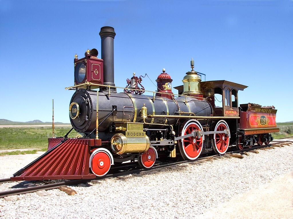
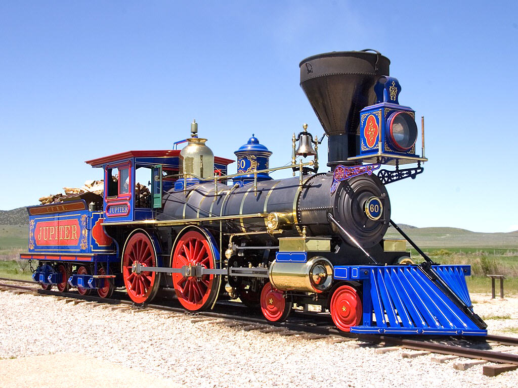
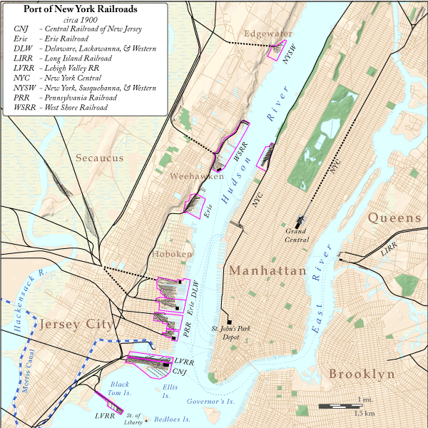