|
Reflections 2021
Series 8
September 21
Rail Gauge Redux: US, Australia; Ireland, Iberia, Russia
Breaks of Gauge: Painless vs Disruptive - Gauge Changers I: Spain
| | This posting continues the potpourri from the previous posting of updates on things we've talked about in the past. | | | | Gauges, Breaks, Gauge Changers Let's try some hypotheticals. What if you were driving on a highway and suddenly came to a break in the road, a point where the highway ahead were much narrower than your car? Perhaps you'd have to abandon your car and rent another narrower one that fit this new narrow stretch of roadway. And coming back, what if you'd have to in turn abandon that narrow rental because the highway was now wider, and you'd pick up your own wider car to get home?
Or try this. Consider someone finding this unusual solution to that break in the highway. As you first drove up to that break where the highway grew narrower, all of a sudden you heard a mechanical noise and found that, on the front axle first, then the rear axle, the pairs of wheels on your car had just come closer together along their axles, so that now your car fit on the narrower road. And on the return trip, at the same point, the wheels shifted further apart again.
That's too off-the-wall to actually happen in a car or bus. Also, I remember saying some time ago that they were trying to do that in trains, for when a train reached a break of gauge. But I must have been sleeping, and haven't been following the amazing things that have been going on with gauge changers that actually do move train wheels closer together or further apart, as needed, so that the train can continue on its route without interruption. So, since we've talked about gauge in the past, this is an update on what's been going on, with a concentration on Europe.
| | | | Rail Gauges There's no need to tell the whole story again, but we should summarize. It seems so simple, yet gets so complex. Rail gauge is the measurement between the inner faces of a pair of rails, shown here being checked for accuracy. (Photo by Sergeev Pavel). Note that it's the inside measurement that counts. As it turns out, this picture was taken in Russia, which uses broad gauge, meaning the tracks are a little further apart than standard gauge (imagine it here), whose tracks in turn are further apart still than narrow gauge. And of course that determines how far apart the train's wheels are, as well as other measurements. So something so simple gets more complex.
First, where are all the railroads? This map shows the world railway network (Map by Jkan997). It's startling to see that the biggest concentrations are in Europe and the US/Canada; India and China-Korea-Japan have massive networks as well. Smaller are Australia, South Africa, and Argentina.
The most frequently found rail gauges, are shown here (Sketch by HTML2011). Start with standard gauge in light blue on the far right at 1435 mm (4 ft 8.5 in), the most common in the world, with 55% of all lines using it. All high-speed rail lines use standard gauge except those in Russia, with Uzbekistan and Finland following suit, since they use Russian gauge.
Various broad gauges are in shades of green further to the right, with the darkest first one being Russian 1520, as in the last picture. The next green is Irish 1600; then Iberian 1668, next to the almost-the-same Indian 1676.
You should keep two broad gauges in mind, Russian Gauge and Iberian/Indian Gauge.
Do understand that normally, broad gauges do not come in contact with each other. What happens is, for instance, standard gauge track meeting ONE of the broad gauges, causing a break in gauge, where trains cannot proceed in either direction. The wheels don't fit on the rails!
Listed below standard gauge in blue in width are a number of narrow gauges in shades of purple and red. Just two are important and worth remembering, tho we'll mention a third one for the record, all three clustered in the center of the sketch.
In purple is Cape Gauge at 1067 mm (3 ft 6 in), named after its use in the Cape Colony, now South Africa.
In violet is Meter Gauge at 1000 mm (3 ft 3+3⁄8 in).
The less significant third one in persimmon, at 914 (3 ft), is usually called Three-Foot Gauge, but it makes more sense to me to refer to it as Yard Gauge, since that name pairs up and contrasts so well to Meter Gauge.
Narrow gauge tracks are also dispersed, and do not come in contact with each other. But like above, they will have breaks of gauge with standard, and rarely, broad gauge. We'll now see where these gauges occur in a worldwide gauge map (no attribution). The same color code applies. Everything shown is a generalization applying to railroad lines only; there are numerous variations for light rail, trams/streetcars, subways, funiculars, amusement parks, and many more.
STANDARD GAUGE is in light blue. Check out these areas on the map.
BROAD GAUGES are in shades of green. Note Russia (with Finland), Iberia, India+, Argentina/Chile, Ireland.
NARROW GAUGES are in shades of purple and red. Cape Gauge in purple, is in much of Africa (whence the name), Indonesia+, Japan, New Zealand, Ecuador. Meter Gauge, in violet, is in Brazil+, parts of Africa, Southeast Asia. Yard Gauge is only in Colombia+, but see below.
Colors in tiny boxes (note Spain, Switzerland) show secondary gauges in that country.
While our purpose here is to discuss breaks of gauge in Europe, I first want to comment on two locations elsewhere.
| | | | United States I wonder if people in the US interested in rail aren't a bit complacent, since major North American rail lines are so completely standard gauge. Who ever heard of a break of gauge in North America? Well, look to the past, and you'll find plenty of broad and narrow gauge lines where perhaps you didn't expect them.
This is an 1861 map of railroads south of the Mason-Dixon line (located between Pennsylvania and Maryland). With the exception of Maryland and West Virginia, the other states with rail lines shown (plus Texas) joined the Confederacy. While northern railroads (not shown) almost completely used standard gauge, standard was only used in the northeastern part of the South, as shown in red. All the green (and orange) lines shown were broad gauge. This resulted in a number of breaks of gauge within the Confederacy, severely hampering their war effort.
How did things change? Retreating Confederate troops generally applied a scorched-earth policy toward railroads, and Union troops would have to rebuild them to make them usable, and of course they were rebuilt to standard gauge, further aiding the North's expansion.
| | | | | | There are world parallels that are so eerie they're amusing. On this last map, there are a very few broad-gauge orange lines, which were built to 5 ft 6 in (1676 mm). This is exactly the same as Indian Gauge, and a hair's breadth different from Iberian Gauge at 1668 mm! But it gets much better. The majority of the broad gauge lines, in green, were 5 ft (1524 mm). This is exactly the same as the original Russian gauge (since adjusted to 1520 mm). And it gets better still. Russian gauge was actually COPIED from this gauge in the American South (more below)! |
| | | | And there were some US narrow-gauge lines as well. I find it best to look at it this way. Historically, meter gauge was used by European colonial powers within their empires. (In Europe, meter gauge remains in some places in Switzerland and as we've seen, in northern Spain.) I look at meter gauge as being Eurocentric.
I see Cape Gauge, since it rose north from the Cape of Good Hope in South Africa, as Afrocentric.
While Yard Gauge (Three-Foot Gauge) had its origins in the British Isles, I think of it as an American narrow gauge, since it gained popularity in North America, and spread sporadically, notably to Colombia. I see it as Americocentric, even tho it's not much in use any more.
So where was/is Yard Gauge in the US? Look at this c1914 map of the Denver & Rio Grande Western Pacific railroad (D&RGW), where red is standard and black is narrow. But 1914 is not nearly early enough, since too much upgrading from narrow to standard gauge had happened by then. In your mind, eliminate the standard-gauge Utah Division in red, all across Colorado via Utah to Nevada and California, and we'll get closer to the origins, when the railroad was founded in 1870, simply as the Denver & Rio Grande (D&RG). It was built narrow-gauge because it costs less and because it can take smaller radius curves, which is important in mountainous terrain. Now picture virtually all of the remaining Colorado routes as being narrow (black). As the name implies, the first narrow-gauge route went south from Denver past Pueblo, in the hope of reaching El Paso TX on the Rio Grande, which as the map shows, never happened.
South of Pueblo, it first zigzagged over to Alameda, then south to Antonito, and got as far as Santa Fe. It tried a second route due south via Trinidad over Raton Pass, but that also stopped at Santa Fe, the furthest south this railroad ever got, nowhere near El Paso and the Rio Grande. Still, at its height in the mid-1880s, the D&RGW had the largest narrow-gauge railroad network in North America with 4,479 km (2,783 mi) of track.
The fact is that the D&RG had to compete with other railroads that were standard gauge, limiting D&RG's ability to connect to long-distance routes. This limitation caused the shift over on even its bread-and butter original routes to standard gauge starting in 1890, which is why so much more red and less black shows in Colorado and New Mexico. We won't go into the remaining takeovers the railroad experienced, but will concentrate on the abandoned narrow-gauge lines in CO & NM.
Now take particular note of the line west out of Antonito, which was built as the San Juan extension over the 3,053 m (10,015 ft) Cumbres Pass along the CO-NM border, reaching Durango in 1881 and continuing north to the rich mining areas around Silverton in 1882. Two narrow-gauge segments of this San Juan Line survive as steam-powered scenic railroads, the Antonito–Chama segment over the Cumbres Pass (see map) as the Cumbres & Toltec Scenic Railroad (C&TS). The other survivor is the Durango–Silverton segment, today known as the Durango & Silverton Narrow Gauge Railroad (D&SNG). Note that "scenic" and "S", as well as "narrow gauge" and "NG", are part of the names and call letters of these heritage railroads.
I rode both those San Juan extension short lines in that order in 2007, and the trip is described in 2007/14. The C&TS, at 103 km (64 mi), is now the longest US narrow-gauge railroad, and was founded in 1970. I found a charming B&B in Chama and chose the full-day excursion out of Chama CO and over the pass to Antonito NM. The trip includes a return bus ride right afterward. The route crosses the CO/NM border a total of eleven times. I drove to Durango, which is a marvelous destination, and then rode the D&SNG as a round-trip day-trip on its 72,7 km (45.2 mi) of track . It was founded in 1881 and has the distinction of running continuously since then.
It's really worth adding one more bit of rail heritage in North America built to Yard Gauge (Three-Foot Gauge), the line originally called the White Pass & Yukon Railway (WP&Y), described in 2005/13, that originally connected Skagway, Alaska, and Whitehorse, Yukon Territory. Now as a heritage railway, it's called the White Pass Route. It was built in the Klondike Gold Rush years and completed in 1900 on this route from AK via BC to YT (Map by OpenTopoMap, Peter Christener). Way back in 1970, Beverly and I tried to ride it one-way over its entire 172 km (107 mi) route from Skagway to Whitehorse, then continue on to Alaska, but when we got there, the railroad was on strike, so instead, they flew (!!!) us from Skagway over the White Pass to Whitehorse.
I went back to Alaska in 2005 (see 2005/13), really enjoyed Skagway and its area, and took the steam train on what was a curtailed route. It did cross the White Pass into Canada, and went to Bennett for an included lunch stop, then returned to Skagway. I've seen trips that went as far as Carcross, and some namby-pamby ones that go only to the summit of the White Pass (No passport needed!!), but they don't seem to ever want to try to go back to Whitehorse. Thus, after the 2005 trip, I rented a car, drove over the White Pass myself, and along the gorgeous Klondike Highway to Whitehorse, which took 2h15, then back to Skagway. Beautiful area; fun trip, even when not by rail all the way.
| | | | Australia The other non-European country to discuss before we talk about Europe is Australia, which has the most unusual rail gauge history. I had a thrilling trip to all corners of Oz in 2010, including riding every major passenger rail line, mostly overnight. 2010/13 is even titled The Great Rail Gauge Conundrum. I find it all comes down to parochialism. In the mid-19C as rail was expanding, Australia was a group of colonies, much as the US and Canada had been, and each colony felt they had to only be concerned with local travel, never imagining transcontinental travel. So standard, narrow, and broad were adopted willy-nilly by the colonies. | | | | | | It was similar in Europe, where each country, tho having several gauges, tended to settle on one. When Nagelmackers wanted to send his first train, the Orient Express, across the continent in 1883, I have an (unproved) feeling he chose the Paris/Constantinople route because the countries involved all used broad gauge. He later wanted to connect Lisbon and Saint Petersburg by one single train, but had to yield to doing it with two trains because of breaks of gauge. Therefore the Paris/Madrid/Lisbon Sud-Express was launched in 1887, running over standard, then Iberian Gauge, and the Paris/Berlin/Saint Petersburg Nord-Express followed in 1896, running over standard, then Russian Gauge. |
| | | | At the time of Australian federation in 1901 when the colonies became states, it became particularly clear that it had been a grave error not to have chosen uniform rail gauge. European breaks of gauge were bad enough, but those were international breaks. Now that the former Australian colonies were one country (Map by Thomas Steiner), it was a more serious situation. And in addition, at that time, Western Australia and the Northern Territory were isolated, having no rail links at all to the other states.
At one early point, there were 16 different rail gauges, some common, some quite rare, in private and public use around Australia.
By 1917, Western Australia had been connected by rail to the rest of the country, but a person wanting to travel from Perth on the west coast, to Brisbane on the east coast, had to change trains no fewer than six times!
By the outbreak of WWII in 1939, there were 13 break-of-gauge locations, with upwards of 1,600 service personnel and many more civilians employed to transfer 1.8 million tons of freight during the period. After the war, the Clapp Report summed up the messy situation of Australian rail gauge as of 1945 (Map by SCHolar44).
| | | | | | The map (click as needed) is very useful, tho for our purposes, we have to be careful. First, blue shows standard gauge. Fine.
Green means narrow gauge that the report did NOT recommend for conversion to standard, so we'll just use it to see where narrow gauge still exists.
But red is used for suggested conversions to standard. So we have to be careful. In the southeast ALL the broad gauge lines were suggested to be converted, but this has happened only on main lines. So we can take red in the southeast to still give us an idea of the spread of broad gauge.
Elsewhere, red and dashed red are also used for suggested changes from narrow to standard. (1) Perth-Kalgoorlie and (2) Darwin-Birdum WERE converted to standard. Picture them blue. Nothing else dashed red ever happened, and the solid red Queensland line out of Townsville remains narrow gauge to this day. Picture it green.
|
| | | | Other than that, the colors tell the gauge situation. New South Wales got it right in the first place, having instituted standard gauge (blue) from the beginning. This is fortunate because of its central location. | | | | | | You can see that standard was due to cross the continent, replacing a bit of red and a bit of green on the way to Perth. This is today the route of the famous Indian Pacific.
In 2004, Darwin was connected to Alice Springs by standard gauge, which involved converting that narrow bit near Darwin. To continue the north-south route to Adelaide, that long stretch of narrow gauge out of Alice Springs and some broad near Adelaide were also converted. Today, the famous Ghan runs this route with no breaks of gauge.
|
| | | | Green shows narrow gauge. Which one? It's all Cape Gauge (1067mm / 3'6"). If I interpret the suggested changes correctly, it was felt that the areas of narrow gauge concentration, Queensland and Western Australia, were less disruptive, as they were more isolated from the populous areas of southeastern Australia, and so few if any changes were made there. | | | | | | We should state the obvious, that islands that have exclusively one gauge cannot have breaks of gauge, so Cape Gauge on Tasmania is not an issue (see above map).
https://www.goway.com/media/uploads/maps/australia_and_south_pacific/kiwi_rail_scenic_journeys_map_83274_(1)_1.jpg
That's equally true for neighboring New Zealand's Cape Gauge, on both North Island and South Island. NZ has more lines than on this map, but they've now declined to just being for freight, while the map shows the three remaining passenger routes, all day trains today. I rode all three, round trip, including the ferry crossings (2009/8-9-10-11 ("Preview"; 19-20-21-22-23 "Trip").
|
| | | | That leaves us with broad gauge, which engulfed Victoria and spread into South Australia up to and beyond Adelaide. As we said, red shows broad gauge, but which one? I was amused to find that of all things, it's Irish Gauge (1600mm / 5'3"), an unusual gauge found only in both parts of Ireland and in southeastern Australia, where it was introduced by the an Irish railway engineer! Anyway, look at the three colors to realize how the problem existed well into the 20C.
https://i.redd.it/obopuwr1sf731.png
This is a contemporary rail map (click), not showing just passenger trains as we did on the Australian postings (and on the above NZ map), but showing ALL lines instead. The amazing progress in rail gauge unification is obvious. The bold yellow lines show that all mainland state capitals (not Hobart, Tasmania) are joined by standard gauge (violet). Compare this with some of the 1945 map changes to see how certain lines were done. The last piece in this "capitals" network fell in place in 2004 with the above-mentioned connection of Darwin to the grid.
| | | | | | Before we take a deeper look, confirm that narrow gauge (Cape Gauge; red on this map) on Tasmania--and also in adjacent New Zealand--remains, and offers no problems. Click to see how more lines there are in NZ than just the three passenger lines of the earlier map. |
| | | | New South Wales, already boasting standard gauge (violet), saw little to no disruption. But other than that, look how Queensland came thru it all so easily, where its large narrow-gauge network (red) remains pretty much the same, and is the second-largest narrow-gauge system in the world. But some of Western Australia's network is now standard gauge; to an extent in the southwest, and totally in the unconnected northwest. But the change in Victoria, running into adjacent South Australia (Adelaide), where the recommendation was total change, is nevertheless notable, where a number of broad-gauge (Irish Gauge) lines (green) have gone standard (violet). (You'll also see that some broad gauge has always invaded adjacent New South Wales for minor distances, and still does.) | | | | | | There's a curiosity shown on this map, the letter S in between two "pins", which indicate a suspended section of track. They're almost everywhere, mostly at the far ends of routes, but two interest me. They're both on the border between Victoria and South Australia, and it's obvious that the suspensions in each of those cases are due to breaks of gauge causing the route to be abandoned in one case and interrupted in the other. |
| | | | On my 2010 trip, I wanted to go everywhere, and did so by train, taking all the main routes. At the time, I was unaware that it had only been six years earlier, in 2004, that the entire network had been completed to Darwin. Follow this "yellow brick road" on the map. All were overnight but one.
Sydney to Brisbane; Brisbane to Cairns, narrow gauge on the Sunlander (since 2015 called the Spirit of Queensland); flight to Darwin; Darwin via Alice Springs to Adelaide on the Ghan; Adelaide to Melbourne on the Overlander (day trip); overnight ferry round-trip to Tasmania (local bus connections); Melbourne to Sydney; Sydney to Perth on the Indian Pacific.
Given the complex nature of setting this up, I'm pleased to say that the only duplication was in that short segment north of Adelaide where the Ghan ran eastbound and later the Indian Pacific ran westbound.
| | | | | | We'll discuss breaks of gauge more fully in a moment, but for now, refer back to 2010/13 and the section on Albury, followed by the section on Mark Twain's humorous woes about his 1895 midnight break of gauge there, since Albury is in NSW and across the river is VIC with broad gauge. Find this on our map. You'll also see the solution, a violet/green dual-gauge connection from Albury south to Melbourne built in 1962. Dual gauge is discussed and illustrated in that posting.
Upon reflection, I now consider there to be two kinds of breaks of gauge. Albury had been a disruptive break of gauge, involving changing trains in a small town "in the middle of nowhere" and during the night. But far less serious is the type of break of gauge I encountered in Brisbane, a major city. I arrived from Sydney in the south on standard gauge, and after my visit, left northward on narrow gauge. It was truly a painless break of gauge.
However, a perceived problem might be that there is no thru service from Sydney via Brisbane to Cairns, so if you don't want to stop in Brisbane, you still have to change trains there. But would a thru train be economically practical? I've crossed the US many times by train and always had to change trains in Chicago (or New Orleans), even tho the US is all standard gauge. There's no break of gauge in Chicago, but it's normal to change trains there, anyway. Sometimes overly long routes are impractical, lessening any significance of a painless break of gauge.
|
| | | | I did a quick calculation of the mainland Australian states' current rail gauge percentages. Measured by state, NSW, SA, & NT are listed as mostly standard by far; QLD is listed as mostly narrow by far, so there are no surprises anywhere there. But most interesting are VIC, which, tho still roughly 55.2% broad, is also 44.9% standard, which is a great leap forward. And WA is now majority standard at 60.5%, while narrow is at 39.5%.
Measured by gauge, nationally 48% of all tracks are standard, 41% are narrow, and 11% are broad. Thus, despite all the history, I was delighted to see Australia listed on the world rail gauge map earlier as being primarily standard gauge. What a great step forward.
| | | | European Rail Gauges After our diversions to the US and to Australia, we finally get to our main topic of European rail gauges and the amazing subject of the gauge changing systems that have been developed in Europe.
But first we have to divide our problems. We saw in Australia that narrow gauge was only a secondary problem, and that all of Queensland and most of Western Australia could be left as is without much trouble. It was the broad gauge in Victoria that stood in the way of progress and needed looking into.
The situation is similar in Europe. Narrow gauge in Europe is Meter Gauge and is very limited. It appears as a local, domestic issue within Switzerland, and also in northern Spain. We'll get to that afterwards. The big issue is broad gauge, of which there are three, one of which is actually a non-issue.
https://jakubmarian.com/wp-content/uploads/2018/11/railway-gauges-europe.jpg
This great map of Europe tells it all. Look at the vast standard gauge area in green. We can see how, as I suspect, one of the reasons Nagelmackers chose Constantinople/Istanbul as his destination out of Paris for the Orient Express, is that it's about as lengthy a route as you can get diagonally across the Continent within standard gauge. Perhaps he waited a few years before he tried dealing with breaks of gauge with his Sud Express to Madrid/Lisbon and his Nord Express via Berlin to Saint Petersburg.
| | | | Irish Gauge Let's deal with the one broad gauge first that's a non-issue, the middle size of the three broad gauges in Europe, Irish gauge, the dominant track gauge in Ireland and Northern Ireland. But like Tasmania and New Zealand, it's an island with no rail connections outside, so there's no problem. Let's take a quick look. This is a 1906 rail map of Ireland (click) showing the extensive rail service across the island, tho some routes are light rail. Sadly, as has happened elsewhere, only about a third of this remains today. Here are today's rail lines (Map by Stabilo boss), run by different companies north and south. There has been a gradual, tho grudging, restoration of some routes. Keep in mind that the rather unique Irish Gauge is what was used in Victoria and into South Australia to Adelaide. | | | | Iberian Gauge Iberian gauge (1,668 mm / 5 ft <6 in) is the dominant track gauge on the Iberian peninsula (see Europe map). It's the second-widest gauge in regular use anywhere in the world. Only Indian gauge (1,676 mm / 5 ft 6 in) is wider, and only by 8 mm (5⁄16 in). A commonly cited reason for the adoption of this broad gauge is that it was intended to hinder any use of the railroad in any French invasion attempt. This is possible, but the 1845 governmental decree simply states the gauge to be used itself, and not any reason.
I think that not everyone realizes what existed before the metric system spread out from France after the Revolution. It wasn't just Britain that used inches, feet, miles, and so on. Most countries used them. The problem was, each country had its own foot, mile, and whatever else. These have now all disappeared, and so we're just waiting for the English system to finally collapse along with the others.
| | | | | | Sometimes interesting adaptations were made. When I first went to Sweden from Mainz to visit Beverly's relatives, I had to get used to the rather large Swedish mil (rhymes with "meal"), also used in Norway. When the metric system was adopted in Sweden in 1889 (Norway 1875), the mil was one measurement that was kept, tho redefined slightly from being ABOUT 10 km to being EXACTLY 10 km (6.2 mi). It's regularly used. If something is 30 km away, you might be told that it's tre mil away. If it's 5 km, it's en halvmil distant. But the term is just colloquial and only kilometers are used on Swedish road signs, never mil. |
| | | | Now in Spain and Portugal, nothing remains of the old feet and inches they had, but in the mid-19C, the old "feet", which were either larger or smaller than English feet, had an influence on rail gauge. The main railway networks of Spain were initially constructed to a gauge of exactly six Castilian feet, or 1,672 mm (5 ft <6 in). (One Castilian foot = 278.6 mm; less than 11 English inches [10.969 in]). This was later reduced by 4 mm to the current 1668 mm to allow interoperability with Portugal.
The networks of Portugal were initially built in standard gauge, which really surprised me. But Portugal is isolated and borders only on Spain, so by 1864 all lines were converted to broad gauge. But did they use Spanish broad gauge? Of course not! Why make things simple? They were rebuilt to a gauge of exactly five Portuguese feet, or 1,664 mm (5 ft 5.5 in). (One Portuguese foot = 332.8 mm; more than 13 English inches [13.102 in].) This difference of 4 mm was close enough to nevertheless allow interoperability in practice.
https://www.acprail.com/wp-content/uploads/2018/04/Portugal-map.jpg
| | | | Portugal In 1987 Beverly and I did a wonderful 23-day car trip completely in Portugal (click; hold on to the above map) based on our customary Michelin guide, driving from end-to-end, literally. We first drove north from Lisbon to the best Michelin-rated destinations as far as Braga and Guimarães, then down along Spain past Castelo Branco to the south coast, where the highlight for me was west of Lagos, the spectacular Cabo São Vicente / Cape Saint Vincent, the southwesternmost point of Europe, and then up back again to Lisbon.
It was a great trip, but it was all by car, so before the 2007 Transcantábrico trip in northern Spain, I started in Lisbon again, and went back to some favorite spots, but all by train. 2007/9 tells about Lisbon and nearby Cascais and Estoril (see map). I then took an express train round trip to Évora where my room was a former cell in a spectacular former 15C convent. Back in Lisbon, I took a tilt-train north to Porto, connecting to Guimarães and later to Viana do Castelo, then continuing north on to Spain, changing trains in Vigo. Everything was broad gauge.
https://preview.redd.it/lpmpewvsuo711.jpg?auto=webp&s=b187049e710e2e4c3e55ae6a064c4455b8a065ff
Portugal formerly had several hundred kilometers of narrow-gauge railways, notably in rural and mountainous parts of the country. The lines were mostly built from the 1880s onwards, with the final line not completed until as late as 1949. The first major wave of closures took place in the 1980s. Lines in the far north were closed in 1990-1991, and others in 2008-2009. See map above (click) to note that the greatest losses were in the northeast and central east.
Now on our main Portugal map (this map, too), look south of Porto along the main line. Between Espino and Aveiro is a small side route, the Linha do Vouga (the Vouga [Valley] Line), opened in 1908. It's the last surviving intercity meter gauge railway line in Portugal. The line is, however, also under the threat of closure.
Now look northeast of Porto to Guimarães. We drove here in 1987, and I took the train round trip out of Porto in 2007, since it's a beautiful place. And now I've found a curiosity I wasn't aware of. The Porto-Guimarães line was built in 1883-1884 as a meter-gauge line that also went a bit east of Guimarães. It was all closed in 1986, and the short section east of town saw its trackbed converted to a bicycle path. It then took a couple of decades, but in 2004, to the west of town and all the way to Porto, the narrow gauge route was converted to the broad Iberian gauge! That means that I rode on a newly revived route that hadn't existed until three years before, and I wouldn't have been able to visit the town earlier by rail. I've seen broad go to standard and narrow go to standard, but I've never heard before of narrow going to broad. When you think of the size difference, it's really a remarkable change.
The first paragraph of 2007/10 says: It’s surprising that Portuguese trains aren’t more international than they are. An overnight sleeper express leaves Lisbon for Madrid, and another leaves Lisbon across northern Spain headed for France. No local trains cross over to Spain, not in the south, not in the east. However, months ago I had located the one that goes north to Spain, twice a day; once inconveniently in the evening, and once conveniently out of Viana do Castelo in the morning, which is the one I took. . . . It wasn’t far on the Portuguese train into Spain to Vigo (BI.go), its last stop, where I connected to the [Spanish] train starting in Vigo headed north . . . with my stop of Santiago de Compostela on the way. To expand on that a bit, let's use this map for a moment:
https://www.holidaysonlocation.com/images/rail/spain-portugal-map.jpg
It shows Portugal/Spain rail border crossings, but don't believe everything you see, according to recent online checking. Find Pocinho in the northeast. It had connected to Salamanca, but was closed in the late 1980s. Find the connection to Cáceres in Spain via Valencia de Alcántara. It's closed, presumably due to low use. From what I can tell, the ones at Badajoz and Fuentes de Oroño seem to be surviving. But then in the north, the one I took at Valença [do Minho] to Tui (not shown) on the Spanish side of the river is doing reasonably well. You can see here how I took a Spanish train from Vigo to Santiago de Compostela, and how the Transcantábrico tour I joined there skipped the next rail connection and bused us to Ferrol for the Transcantábrico trip.
| | | | Spain We've used this next map before to show the rail gauges in Spain as of 2015 (Map by Manchego). [You can now see Tui on the border, plus Vigo, Santiago, and Ferrol.] But this time I've worked out percentages as of 2019 of interurban rail gauge (no statistics in this posting include tracks in subways, amusement parks, or the like).
Red shows broad Iberian gauge 1668 mm, 70%.
Blue shows standard gauge 1435 mm, used for the new high-speed lines, 18%.
Green shows narrow metric gauge, 1000 mm, 11%.
| | | | | | On our Spain map, find the island of Mallorca on the right. I was just going to mention that its narrow gauge is not a problem, since it's an island. Then I learned more, so let's look at rail on Mallorca (Map by OpenStreetMap contributors). All three lines are privately owned, and were all originally Yard Gauge (Three-Foot Gauge) of 914 mm. The company that owns the two blue lines converted them to meter gauge, 1000 mm, in the early 2000s. It also has plans to expand to Artà. However, the company that runs the orange line and its tramway extension to the port remains at yard gauge. And so this yard gauge accounts for the remaining less than 1% in the above tally. But another interesting point is the flip-flop between two narrow gauges. |
| | | | So it's still overwhelmingly Iberian, with inroads for standard coming because of high-speed rail. But plans do exist to convert more of the Iberian-gauge network to standard gauge. This is indicated by the fact that, when several stretches of broad-gauge track were recently relaid, concrete sleepers were used that had pre-drilled additional bolt holes. These holes would allow the easy repositioning of one of the rails to make the pair of tracks standard-gauge width. Better still, this way both rails could be moved closer together for standard gauge, which would maintain perfect alignment of the loading gauge so that trains would continue to platform correctly.
In 1985, Beverly and I took an extensive, 33-day driving tour of Spain, covering all the major Michelin sights, and in 1990, we lived in Málaga for two months studying advanced Spanish, and also drove to many places from there. So the 2007 trip coming up from Portugal was far from the first. But the only Spanish train we'd ever taken was a short ride from the airport into Málaga, so 2007 was quite different.
RENFE is the REd Nacional de los Ferrocarriles Españoles (National Network of Spanish Railways), and was traditionally associated with Iberian gauge. FEVE was the FErrocarriles de Vía Estrecha (Narrow-Gauge Railways) company, mostly associated with the large north-coast route along the Cantabrian Sea, the southern part of the Bay of Biscay along Spain's north coast. That's the basis for the name of the cruise train "Transcantábrico". When I took it in 2007, I thought it was privately run, but now learn that FEVE itself ran it. I've also learned that in 2012, the Spanish government merged FEVE into RENFE, including transferring to RENFE the rolling stock and the brand name FEVE, so that the company is now called RENFE FEVE.
| | | | | | Our map of Spain also shows that south of Valencia on the east coast, the government operates a narrow-gauge (meter) route between Alicante and Dénia. This is being upgraded from a railway to a modern tramway. |
| | | | We have a more detailed map of the route of FEVE's Transcantábrico (Map by David), and it shows a slight shift. While broad gauge lines are in red and show the breaks in gauge (all "painless"), FEVE lines are in green, and Euskotren's lines are in yellow. Euskotren is one of the Basque rail companies that took over FEVE lines that were located within the Basque Country, from the Bilbao area all the way up to the French border at Hendaye.
After I came up from Portugal by (broad-gauge) train to Santiago de Compostela (off the map, left), came that busing to Ferrol. The Transcantábrico cruise train trip ran the whole route, with many stops, from Ferrol via Oviedo and Santander to Bilbao. It never went further east into the Basque Country, so my feeling is that I experienced the whole FEVE route, since the train then continued on to León, making the route wishbone-shaped. After visiting León, I took a regular FEVE train back to Bilbao, and then the overnight ferry to Portsmouth UK (2007/10).
Look again at those painless breaks of gauge on this last map. In 2007/10 I wrote: Some cities are served by both FEVE and RENFE. In León they have two different stations; in some (Bilbao, Santander) they have immediately adjacent stations. Only in Oviedo did I see them literally share a station, and, since I had a few moments, I went to check them out. There was an overhead walkway above giving access to all the tracks, the first four for RENFE, then four for FEVE. When the trains had left the adjacent contrasting tracks, you could look down and compare the narrow and broad tracks next to each other, and the difference was startling, like Baby Bear next to Papa Bear, standard-gauge Mama Bear being nowhere in sight.
http://www.willylogan.com/wp-content/gallery/misc-post-photos-2/30881-meter-gauge-broad-gauge-comparison_1600px.jpg
The above picture was taken in India and shows a narrow gauge track running next to a broad gauge track. Indian broad gauge is the broadest in regular use in the world, at 1,676 mm (5 ft 6 in), but it's only a miniscule 8 mm (about 5/16 in) wider than the second largest, Iberian, so let's say the right-hand one in the picture is Iberian. Thus this outdoor aerial view in India replicates the startling view from above I had indoors at Oviedo station. FEVE's narrow (meter) gauge is 30% less wide than standard gauge, while RENFE's Iberian broad gauge is 16% wider than standard gauge, so the difference is about half. But comparing the two extreme ones in the picture is startling: FEVE's width is only 60% of Renfe’s. In the picture it looks like a toy train uses the left track, but that's really just the contrast between the two, since narrow-gauge trains run perfectly well. Now visualize the extraordinary conversion from narrow to broad that was done in Portugal between Guimarães and Porto.
| | | | Russian Gauge Check again the European gauge map from the beginning of this section and compare Iberia to Russia, our third broad-gauge area. One point needs to be made immediately. As we said earlier, narrow gauge in Europe is at most a secondary problem, since it's limited to northern Spain and to some lines in Switzerland. But we just saw that any breaks of gauge in Spain are painless. We'll see about Switzerland in the next posting.
As for Russian gauge, it's widely and incorrectly believed that Imperial Russia chose a gauge broader than standard gauge for military reasons, namely to prevent potential invaders from using the Russian rail system. That's what we also heard about Spain, with no proof. But as for Russia, it's an urban myth. Since the gauge was originally 5 (English) feet, I always felt there was British influence in that decision. After all, Britain was an early center of rail development, and France had British engineers lay out its first railways, which is why French trains to this day run on the left, even tho the Métro and the roads run on the right. But it wasn't a Brit that chose five feet—it was an American.
In 2014/15 we talked about the first passenger railroad in Russia, the Tsarskoye Selo Railway that opened in 1837. I now find it had a very broad gauge of 6 ft (1,829 mm). It seems the consultant was an Austrian-Czech, and it's unclear why he would have suggested a gauge in English feet. Speculation: the British rail system is the oldest in the world and its various rail gauges were in English feet.
For the building of Russia's first major railway, the Moscow–Saint Petersburg Railway, I wrote in 2013/24: The individual who is actually credited with making the decision for broad gauge was a prominent American railroad engineer, George Washington Whistler. He had been hired [by Nicholas I in 1842] as a consultant to build the first major Russian railroad between Moscow and Saint Petersburg. European engineers had recommended a broad gauge, and Whistler was familiar with, and a proponent of, the five-foot broad gauge which was apparently common in the US South at the time. He lobbied for the broad gauge . . . We saw above a map of this broad gauge in the American South.
| | | | | | I also added: Whistler came down with cholera in Saint Petersburg and died at the age of 49 in 1849. He left his second wife, Anna McNeill Whistler, with whom he had had five sons. She was to become wildly famous 22 years later, in 1871, when their eldest son, James McNeill Whistler, painted her portrait, the painting commonly known as "Whistler's Mother". . . . But the bottom line here . . . is that, when considering Russian rail gauge, consider not Whistler's Mother but instead Whistler's Father. |
| | | | The elder Whistler recommended 5 ft (1,524 mm) on the basis that it was cheaper to construct than 6 ft (1,829 mm) that had been used earlier, while still offering the same advantages (perhaps a smoother ride??) over standard gauge at 1,435 mm (4 ft 8.5 in). He also argued that there was no need to worry about any breaks-of-gauge since Russian rail would surely never be connected to the Western European railways. [This is as equally shortsighted as was done in colonial Australia, but that was mid-19C localized thinking.] The plans were approved by Tsar Nicholas I in 1843. The next lines built were also approved with this gauge but it was not until 1860 that a Government decree stated all major railways in Russia would be 5 ft (1,524 mm) gauge.
That would sound like the end of it, until modern times. In the 1960s, during the time of the Soviet Union, Russian gauge was re-standardized from 1524 mm down 4 mm to 1,520 mm. Finland, however, retained the original gauge with no further adjustments, which explains why, on our European gauge map, Finland is set slightly apart. As we now know, Portugal should also be set apart from Spain for its 4 mm difference, but that isn't done on this map.
https://thepeoplescube.com/images/various_uploads/Map_USSR_Republics.jpg
So today Russian gauge predominates in 17 countries. First, in all 15 countries of the former USSR as shown above in color. Clockwise, they are: Russia . . . Kazakhstan, Kyrgyzstan (blue), Tajikistan (gold), Uzbekistan, Turkmenistan . . . Azerbaijan (gold), Armenia (red), Georgia (gold) . . . Moldova (green), Ukraine, Belarus (blue), Lithuania (gold), Latvia (green), Estonia (gold).
But the other two aren't in color on this map. Finland is #16 using Russian gauge because it was part of the Russian Empire until 1917, and during the great rail-building period.
And Mongolia is #17. It was never part of Russia, but adopted Russian gauge because of expediency, avoiding being linked to Chinese standard gauge and turning to Russia instead.
| | | | | | Mongolia did the same with its alphabet. European alphabets have been adopted in some Asian languages. Vietnamese is written in the Latin script, but that shows the influence of it having been part of French Indochina. (But so were Cambodia and Laos, and they kept their alphabets.) Indonesian uses the Latin alphabet, but that reflects its history as a Dutch colony. Several minor languages of India use the Latin alphabet as well, tho very few. Yet when Mongolia decided to give up its native alphabet, it chose instead Russian Cyrillic. The country is called Монгол Улс / Mongol Uls, or "Mongol Nation". The capital city, which used to be anglicized as Ulan Bator and is now Ulaanbaatar, is spelled locally Улаанбаатар. |
| | | | As to the eastern Baltic area, we need to mention again our discussion at the end of 2020/8 about the proposed standard-gauge Rail Baltica railway and the Tallinn-Helsinki Tunnel (Map by Szczureq). The eastern Baltic would love to have a standard-gauge connection to the west.
My only rail connection in the Baltics was minimal. When we drove to and from the Soviet Union in 1972, we drove from Czechoslovakia to Ukraine and Russia proper, but made various complex connections (train, car, short plane ride) to see Belarus, Lithuania, Latvia, and Estonia, before driving out to Finland. The only train connection worth mentioning within the Baltics is the overnight train from Riga back to Moscow.
As for Finland that year, driving up from Saint Petersburg, we only visited Helsinki, after which we took the car ferry to Travemünde in Germany. I returned to Helsinki in 2006 by ship from Stockholm, then again on to Travemünde by a second ship (2006/9). At that time I did take a fabulous round-trip day trip by train from Helsinki to Turku (click on map).
I've checked as to Finland's rail border crossings. Because of its shape, facing water on two sides, you'd expect few crossings. There is a rarely used freight-line crossing to Russia at Vartius. However, Vainikkala is the main crossing to Saint Petersburg for passenger and freight trains. I checked road crossings, and know we drove into Finland closer to the coast than that.
But Finland does have a genuine break of gauge, a hitherto disruptive one, with change of trains, and that's with Sweden, way up north, where the Finnish town of Tornio faces the Swedish town of Haparanda (not shown). A single Swedish 1435 mm gauge track extends to Tornio and a Finnish 1524 mm gauge track to Haparanda, both tracks interlacing across the border bridge. However, connecting passenger service stopped in 1992. But that's turning around. Haparanda station has just been refurbished and service is due to resume. I've been assuming that apparently this will remain a break of gauge, but have also read that a Talgo gauge changer on the Swedish train and at Haparanda is being installed at this crossing (see below).
| | | | Reasonable Tolerances We've talked about things coming close in size, but being slightly different, yet that didn't matter. But we're not talking about brain surgery here. With rails, a reasonable tolerance is allowed, and works just as well as perfect alignment. We've talked about a 4 mm difference between Spain and Portugal; pre-standardized Russian versus standardized; Russia versus Finland; and an 8 mm difference between Spain and India, should one country want to sell used rolling stock to the other. Look at it this way. 4 mm = c 5/32 in, or 2.5 sixteenths on your ruler. Or this way: A standard drinking straw has a diameter of 5 mm; a "slim straw" served in a cocktail is 3.9 mm—call it 4 mm. Now if the total difference in gauge is 4 mm, remember that the left and right wheels are each only 2 mm "off", or half of a slim straw.
Even with a difference of 8 mm, it's possible for trains on Iberian gauge (1668 mm) and Indian gauge (1676 mm) to travel on each other's tracks with no modifications in the vast majority of cases. Note that a hexagonal #2 pencil has a diameter of 6 mm between sides of the hexagon and 7 mm between the angles, so the Iberian/Indian difference of 8 mm is just a bit more than a pencil width—and that, too, is split between the left and right wheels.
| | | | Break of Gauge We now come to the crux of this discussion, breaks of gauge; not the painless ones in larger cities as we've seen, but disruptive ones in the "middle of nowhere" that seriously interrupt a trip. The oldest way of solving this problem was a change of train. When Nagelmackers sent his Wagons-Lits Sud Express from Paris to Madrid and Lisbon in 1887 via the small-town crossing near the Atlantic shore from Hendaye, France over to Irun, Spain, passengers had to change trains. We followed his Nord Express from Paris via Berlin to Saint Petersburg as of 1896, and as they crossed from the German Empire at Eydtkuhnen into the Russian Empire at Wirballen--two flyspeck towns--passengers would transfer across the platform to a twin train in Russian gauge (both breaks described in 2020/8). The more amusing disruptive break of gauge involved Mark Twain in Australia in 1895. We just mentioned above his midnight change of trains in the station at the medium-sized town of Albury (2010/13), where Twain said: Think of the paralysis of intellect that gave that idea birth. Fortunately, the Albury disruptive break of gauge is now solved.
In preparing this, how quaint, I thought. Who would put up with such disruption today? Then I smacked my head as I realized: I already did!! It isn't that I'd forgotten about my experience in Zweisimmen, Switzerland in 2008, going from standard to narrow gauge, it's just that it wasn't really all that disruptive since it was made so festive! Everyone had been alerted well in advance, was sold two tickets, one for each train, it was a beautiful, sunny noontime in the Alps, and it was almost party-like as everyone almost levitated en masse across the platform to the other, waiting train. I'm sure it didn't take more than a few minutes. For a "disruptive" break of gauge in a mid-sized town it wasn't that much of a problem, and bordered on being fun. But it's been taken care now, and will not happen the same way in the future. We'll describe in the next posting how that trip worked, how the transfer went, and how the matter is being amazingly taken care of. (Hint: gauge changer.)
But most disruptive breaks of gauge aren't so pleasant, and there are quite a number of such breaks around the world. Many major ones are resolved by executing a change of bogies. If you can't imagine such a thing, it's quite a surreal experience, tho it can be done relatively quickly. Think of a model train enthusiast lifting a passenger coach off the track to service it and you'll have an idea of what we're talking about, but with a real train.
http://www.parismodedemploi.fr/wp-content/uploads/2017/11/train_paris-est_moscou-1024x616.jpg
One of the principal breaks of gauge with changes of bogies is in Brest, seen above on the main line from Russia to western Europe. We mentioned it when talking in 2020/8 about the Moscow-Paris Express, which could be considered in a way a successor to Nagelmackers' Nord Express from Paris to the Russian Empire. Brest is located today in Belarus, just east of the Polish border, where Russian gauge confronts standard gauge.
We would be negligent to talk merely about rail in Brest without mentioning some of the extraordinary history of the region, an area of significant border changes. Perhaps you remember some of it as I do from high school and college history classes, but it's worth brushing up. I remember a certain Treaty of Brest-Litovsk, and remember nothing about what it dealt with, so I looked it up. It dates from 1918 and was an early peace treaty between the new Bolshevik government in Russia and the Central Powers (the German Empire, Austria-Hungary, Bulgaria, and the Ottoman Empire), and ended Russia's participation in WWI. It was signed on 3 March that year in German-controlled Brest-Litovsk. The treaty was annulled by the Armistice later that year on 11 November when Germany surrendered to the western allies.
That begs the question: what's Brest-Litovsk? Is it another city? Does it designate twin cities? Not at all, a little research tells me. Brest was part of the Russian Empire for a long time. The Russian name for Lithuania is Литва / Litva. Brest-Litovsk simply refers to Lithuanian Brest (as tho there's another Brest), since, from the late middle ages to 1795, Brest was within what was formally known as the Kingdom of Poland and the Grand Duchy of Lithuania. But hasn't been involved with Lithuania for a long time, and isn't even Polish anymore--this is why we have to review all these local border changes.
It might have still been in high school, but was definitely in college that I learned about the three Partitions of Poland in the late 1700s, and we can review those now. Russia, Prussia, and Austria took big bites out of Poland in 1772, then waited 21 years before doing it again in 1793, and again two years later, in 1795, when Poland ceased to exist for over 123 years until after WWI. Here are the partitions (Map by Halibutt). The three blue areas in the west went to Prussia, including Gdańsk/Danzig, Poznań, and, most notably, Warsaw in the last bite. The two green areas in the southwest went to Austria, including Kraków, Lublin, and Lviv (today in Ukraine; Polish Lwów; English Lvov, based on Russian; German Lemberg, based on its Austrian years). Russia took the largest bites, the three brown areas, including Vilnius, today's capital of Lithuania (Polish Wilno), Minsk, today's capital of Belarus (Polish: Mińsk), and—right in the center—Brest-Litovsk (Polish: Brześć Litewski), then as today on the Bug River--Bug rhymes with Luke (Map by Kmesser).
https://i.pinimg.com/originals/f6/df/52/f6df52fd40740cf15f84cdd353244778.jpg
That was the 18C. In the 20C, when Poland reappeared after WWI, it had the white dotted lines on the above map. Check out the cities we've mentioned. But after WWII, vast lands were exchanged, and Poland today lies within the dark gray area. That means that (check map) Vilnius (Wilno, Vilna) went to the USSR, but specifically to Lithuania, to become its capital. Lviv (Lwow, Lvov) went to the USSR, but specifically to Ukraine. And Brest-Litovsk (on the Bug) went to the USSR, but specifically to Belarus, simply as Brest.
I don't have any data on where the break of gauge was on this route before it ended up in Brest. But since Poland was within Russia up thru WWI, it's safe to assume that it was at the border of the German and Russian Empires (Map by Varmin). We saw with Nagelmackers Nord Express that the change was where Germany bulged into Russia, so we can assume it was, further south, where Russia bulged into Central Europe.
Brest in Belarusian is spelled Брэст with one kind of E, but in Russian as Брест, with another kind of E. Similarly, Minsk in Belarusian is spelled Мінск, with a dotted I, but in Russian it's Минск, with the other kind of I.
This map shows the six regions of Belarus (Map by Arz, Stefan Ertmann). You can also trace the train line from Russia via Minsk to Brest and beyond to Poland. Not only is Brest a major break of gauge where bogies are changed, but it's the place where I personally experienced the break and the change of bogies. It was in 2005 on the Around-the-World-by-Rail trip that included the Golden Eagle in Siberia. I took the train from Moscow Belarusskaya Station on the overnight trip. In 2005/10 I wrote: The train . . . entered Belarus, stopping at the capital, Minsk . . . . My grandparents came "from Minsk", but never further defined any details. They were farming people, so they certainly didn’t come from the city, yet the family knows the name of no village near Minsk that they actually could have emigrated from.
Even tho Beverly and I had visited Minsk in 1972 on our trip thru the western USSR, I felt no personal connection to the city, knowing they came from the countryside. But I can now update all that. For a long while I've known my paternal grandparents emigrated from the village of Paduli near Benevento, not far from Naples, and Beverly and I even did a quick visit to Paduli. But the situation with my maternal grandparents was as above. It was only with further review that I realized, and told my family, that Minsk is also a region (province), and that's the "Minsk" the grandparents were talking about. I then came across some family documents and finally discovered the name of the village that had never been passed down on my mother's side.
Its name is Шацiлы / Shatsily, and you'll note it's written with the dotted I. Google Earth showed me it's just northeast of the larger town of Дзяржынск / Dzyarzhynsk. It's not as hard to say as it looks: dzyar.ZHYNSK. And I also found that Dzyarzhynsk was indeed in Minsk province, just southwest of the city of Minsk. And with the current research it got even better. I found this excellent rail map of Belarus (Map by Homoatrox). And now I know for a fact that when, in 2005, we left Minsk for Brest, we definitely passed right thru Dzyarzhynsk (see map—it's transliterated slightly differently) and Shatsily would have been adjacent. It was an express train, so it wouldn't have stopped in any case, but now I know I was right in this maternal family heritage area as I'd been on the paternal side in Italy.
On to Brest and the bogie change. In 2005/10, I added: Brest is on the main line from Moscow to Western Europe, and I knew we were in for some mechanical activity, but the fact that it took 2 ½ hours did surprise me. [Fortunately, we also changed time zones and gained two hours. It would be worse timewise eastbound.] After the Brest [city] station but before crossing the Polish border, the train pulled into a large hangar-like glass shed. We couldn’t get out, so I couldn’t see how long the shed was, but presumably covered all 4-5 cars that were proceeding beyond Brest. Another train pulled in next to us, and I could watch the activity there. The bogies under the carriages were disconnected, and several huge jacks on either side of each carriage raised it up quite a bit. They then slid new bogies under which pushed the old ones out of the way. Then the carriages were lowered, and eventually, we went on to Poland [and Berlin].
I have a rather good still photo of the bogie change at Brest (Photo by Vedenei). You see the yellow jack holding the car aloft while the bogies are rolled in and out. You also can tell that the tracks are dual gauge—the two standard-gauge tracks are between the two Russian-gauge tracks so each set of bogies can use the tracks of its width. You may agree that this bogie is standard gauge, since it's on the inside track. And this is a Russian train. Perhaps you remember the bright red logo of Russian Railways (Image by Юсуф l Александрович). It's tricky-cute. It shows the three lower-case letters, ржд, but the double trident ж in the middle overlaps the two outer letters.
But we have, better still, two YouTube videos. The first is a time-lapse of the bogie change at Brest on the Paris-Moscow Express in 2017. I've set it to start at 0:36; it then runs to 1:14, but you can stop it at 1:00. After the old bogies are disconnected, the yellow hydraulic jacks raise the body of the car, and bogies of the new size are slid under, pushing the old bogies out at the other end. The new bogies are then connected and the train is off.
The second one is changing bogies at Brest in 2016 on the train between Moscow and Prague/Vienna (2:35). It's perhaps a clearer view of the process. At one point at least, you can also see how a cable is pulling all the bogies. Starting at 1:47, you can see how a guy has decided "his" bogie is arriving. At 2:00 he pulls a pin to separate it and then maneuvers it by hand and rolls it back—that's how well-balanced the bogies are.
| | | | Gauge Changers When a train has come to a break of gauge, we've seen (1) a change of train. We've seen (2) a change of bogies. How about making it really simple and trying to just have (3) a change of wheel location on the axle? We're just talking about moving the wheels closer together or further apart while they stay on the bogie so the wheels can fit the new track gauge up ahead. This is the revolutionary development we've been leading up to. But as easily as that guy in Brest was able to roll the bogie, still each wheel can weigh up to a ton. So how do we do it?
You need two things. You need some device in the track bed that makes it happen. That's the gauge changer. The other thing is more difficult. Traditional trains can NOT cross over a gauge changer because their wheels aren't set to change—the wheels don't move left-and-right along their axles. Either train cars need a new kind of bogie with shiftable wheels, retrofitted in place of the traditional bogie, or it might be desirable to have an entirely new coach, built with the new type of bogies right from the start. Pairs of wheels that are capable of moving inward or outward are called variable gauge wheelsets.
| | | | | | Similar systems for freight traffic are still in very early stages, since the heavier weight of freight on axles and wheels increases the technological challenge. |
| | | | Several systems have been developed for changing gauge, most of which are not compatible with each other. We'll mention two of particular importance to our discussion, the Talgo-RD system from Spain and the system developed specifically for the Montreux-Oberland Bernois (MOB) railway, in Switzerland, which is the one involved at Zweisimmen. (Don't giggle at the acronym MOB. It's a fine railroad.)
Both systems are of interest, but they vary considerably.
| | | | | | 1) Talgo changes between broad and standard gauge.
2) Talgo uses an axle, but it's a special variable-gauge axle.
3) Talgo started in Spain, and is used all across Europe.
4) Talgo's system doesn't adjust to platform heights, which is apparently not necessary.
5) Some Talgo trainsets also have variable wheelsets on their power cars, but others have locomotives, which need to be changed.
| 1) MOB changes between narrow and standard gauge.
2) MOB gets the job done with no common axle involved whatsoever. (!)
3) MOB is in Switzerland, and seems to use the changer only for itself, at Zweisimmen.
4) MOB's system adapts coach floor heights to match platform heights, which vary by 180 mm (7 in).
5) MOB's system as to power cars is uncertain, but I believe that's what they use.
|
| | | | Talgo RD We've seen how Talgo is known for innovation when we talked about their single-axle bogie between cars, leading to articulated trains, and tilt trains that ease movement thru curves. In addition, their wheels are the only ones that can rotate independently on the same axle to improve comfort and reduce wear. So it should be of little surprise that they are leaders in variable gauge systems, with their technology having been in use since 1969.
But how can they do it with so much rigidity in rail construction? In Talgo's system and all others, it starts with the rails. At the point where the gauge changer mechanism has been set up between the pair of tracks, the rails themselves are designed to flare out gradually in that short stretch from narrower to wider (or vice versa in the other direction).
Then on the bogie, the wheels have to be loosened so they can shift themselves as the track widens or narrows. Picture a child's toy wagon that'd developed a loose wheel that wobbles along its axle. That's the main step that has to be reached—loose wheels. But no arm or lever reaches out to move the loose wheels—they move by themselves, just following the tracks.
Let's call the wheels shifting themselves Step 3, since it's the middle of five steps. How to you loosen them, and then tighten them up again? In Step 2, a mechanism reaches up and lowers a pin from each wheel, unlocking it so it can move. Then in Step 4, another mechanism reaches up and pushes the pin back into place, safely relocking the wheel.
That might seem to be it, except for the fact that none of this can be done if the wheels are supporting the train. Therefore, the gauge changer in the ground has a short, raised rail on either side of the gauge changer, which acts as a sliding guide. So in Step 1, an arm from the bogie rides up on the sliding guide temporarily lifting the weight load off the wheels so they can shift themselves. After it's done, in Step 5 the bogie is lowered again. This is the sequence: lift, unlock, wheel moves itself, relock, lower.
I have a YouTube video animation of how it happens. At only nine seconds, it's the shortest video I've ever presented, but shows what happens most clearly of all the videos on the subject I've reviewed. I suggest you watch it more than once, and also pause it as needed. Another choice is to click on the white gear at the bottom right and set it at half speed (0:5) or even quarter speed (0:25).
This is the Talgo-RD gauge-changer system.
Before you run it, leave it at 0:00 as you inspect the various parts, shown all at once. As it starts, you see (1) in purple at either end the sliding guides taking the weight. Then in the center, (2) two red devices from the changer down below lower the purple pins to unlock the wheels. As the wheels run along the green tracks, which become ever narrower, (3) the wheels shift as well. Then (4) the red devices push the pins back into place to relock the wheels, and finally the bogie (5) leaves the sliding guides and takes over the weight of the train again.
This is a view of the single-axle Talgo bogie from the side (Photo by Timothy E Baldwin). I have to admit I do not know just what part of it rides along the sliding guide. Worse, unless a roller is somehow involved, there must be a huge amount of friction for this short distance. We'll see below how water is used to abate that, but there must be a huge amount of wear where the guide meets the bogie.
I do not particularly care for the next video, but it has the advantage of being partly animated and partly live-action, for those who want to see both. I've set it to start at 2:35, and suggest you stop it a minute later at 3:35. Here's the alternate video of the Talgo RD.
| | | | Power Cars We have to rethink exactly what a train is. In 2014, as part of the China trip, a section of 2014/3 was called "The Word 'Train'" (check it out—I won't repeat it all), and we discussed that French traîner (tre.NÉ) is "to drag", resulting in both the French and English word "train". In the other Germanic languages, the words derive from "to pull". So the imagery is always of a locomotive pulling or dragging a series of passive cars that can't move themselves. And as we've seen, these cars can be separated and become Kurswagen, going their own way—as long as another locomotive came along to pull them out of their passivity.
But in that posting we also talked about EMUs, and joked about their not being the same as the Australian bird. EMUs are Electric Multiple Units, which are coaches/carriages that are all on their own. They don't need a locomotive, but one or several cars has its own electric traction motor, and there's a location up front for a driver/motorman/"engineer" to drive the train. Subway trains are EMUs as is most commuter rail. This is a commuter-rail EMU in London at London Bridge Station, heading for Charing Cross Station (Photo by Roger Carvell). EMUs are popular on commuter rail due to their fast acceleration and pollution-free operation. They are also quieter and can operate late at night without disturbing residents. And they are not new. The oldest EMU opened in 1893 on the Liverpool Overhead Railway as seen here in the Museum of Liverpool (Photo by Mike Peel).
To be most precise, there are four types of car that an EMU trainset may be comprised of, a power car (draws power from pantographs or third rails), motor car (carries the traction motor, but is often combined with the power car for convenience), driving car (contains the driver's cab—there's often one at either end), and trailer car (is the traditional passive car that does nothing—is most likely a coach or other passenger car). But that's kind of splitting hairs, as these functions can all be mixed-and-matched, with cars having multiple purposes such as combining the power and motor car—with a driver. Some of the more famous EMUs worldwide are the Pendolino in Italy, Shinkansen in Japan, the ICE 3 in Germany (Photo by Sebastian Terfloth), and the CRH (China Railway High-Speed)--note the power car at each end (Photo by N509FZ).
So the three possibilities are now: 1) a locomotive pulls passive cars; 2) a consist of EMU cars actively drive themselves; 3) a consist of EMU cars localizes self-drive responsibility to the first (and maybe also last) car, but it's not a locomotive, just a specialized EMU, referred to as the power car, and not detachable.
| | | | | | But we still call all the possibilities "trains". Also in 2014/3, we talked about the Russian (and Ukrainian) word for "train", поезд (PO.yezd), in Ukrainian spelled поїзд. See that posting for details of the word's origin, but the essence is that [t]he imagery here has nothing to do with dragging or tugging. Instead, the vehicle you're in is described more as a "rider" or "traveler". Describing a train as a traveler would seem a bit more elegant than describing it as a dragger or tugger. And, when including EMUs, where dragging is not involved, boarding a "traveler [on rails]" to ride between cities forms a pleasant image. |
| | | | With this knowledge, we can proceed to statements I've come across about gauge changers that confuse locomotives and power cars, which very possibly also remain confused in the public mind, which presumably thinks that all trains have locomotives. I've seen this statement: The Talgo system was also applied to locomotives in the late 1990s. Taken at face value, that's impossible. I cannot imagine a huge locomotive, either a traditional steam engine, a diesel locomotive, or a diesel-electric, possibly shifting wheels at a gauge changer. But if the statement really refers to power cars, which are simple EMUs anyway, it's not only possible, but is most likely the case. When we hear of an entire train crossing a gauge changer it's surely either a plan EMU or what we've called a specialized EMU with a power car. | | | | Where is the Talgo RD used? The Talgo system is the industry leader, and, quite simply, it's used where it's needed. Counterintuitively, narrow/standard isn't a real problem. In Spain we saw with the FEVE route that no high-speed route reaches that area, thus, neither do any standard gauge lines. (We'll see about Switzerland later.) It's broad/standard where the conflicts lie. Where in Europe does that happen? Ireland has broad, but not standard. So it's going to come down to Iberian and Russian gauge conflicting with standard, so let's see what we're dealing with.
The Russian vs standard difference is 85 mm (3.35 in), which is really 42.5 mm (1.675 in) on each side, which is about 2.5 finger-widths per side, 5 finger-widths total (no thumbs).
The Iberian vs standard difference is 233 mm (9.17 in), which comes to 116.5 (4.585 in), which is about 7 finger-widths per side (no thumbs), double that for the total.
WITHIN SPAIN: Because of its large blend of gauges, Spain is the largest user of variable gauge systems. We've used this rail-gauge map of Spain as of 2015 before (Map by Manchego) and will be needing it again, so I'll give the link so you can hold on to a copy for a while:
https://upload.wikimedia.org/wikipedia/commons/thumb/f/fc/Red_actual_de_ferrocarriles_de_Espa%C3%B1a.svg/1280px-Red_actual_de_ferrocarriles_de_Espa%C3%B1a.svg.png
Note again that narrow gauge lines are out-of-the way and of little problem. But note the traditional Iberian-gauge lines in red and the new high-speed standard-gauge lines in blue. Now compare it with this map showing the location of gauge changers as yellow dots--lines without variable gauge services are not displayed (Map by HrAd). This map is also several years old, so there may be more now. And here we have a Talgo train operated by Renfe as it passes thru a gauge-changing facility in Valdestillas, just south of the major city of Valladolid (Photo by Melcoman en Ferropedia). What Talgo calls its Talgo 250 class (Renfe class 130) is a high-speed dual-gauge, dual-voltage trainset consisting of 11 Talgo tilting coaches and two power cars. The style of train has a nickname. A pato is a duck, and a patito is a duckling. These trains have been nicknamed patitos because of the shape of the nose of the train. It's one of Talgo's premier trains, and gets the number 250 since its maximum speed is 250 km/h (160 mph).
A Talgo-RD gauge changer is 20 m long and 6 m wide (66 x 20 ft). This is a YouTube video of a Talgo gauge changer in action. It's set to start at 0:07 and runs only to 0:52). Note how the power cars at the beginning and end of the train also get their wheels changed at the facility. You'll also see the constant spray of water from the side on the external sliding guides that temporarily bear the weight of the train. It's to lubricate them because of the friction, to reduce heat and wear. Also note that the wheels are on single bogies.
As for speeds, the train passes thru the gauge changer at low speed, up to 15 km/h (9 mph), without stopping, unless it has a locomotive, which would have to be removed (see below how). The gauge change could be performed up to speeds of 60 km/h (37 mph), but the mechanical wear would be much higher. The system is rather robust, only winter with snow and ice can be a problem. Talgo claims that its high-speed Talgo 250 could go thru the gauge changer at the maximum speed the train can run, 250 km/h (155 mph), but I'm very dubious about that, certainly not for regular use.
https://sunflowerbooks.co.uk/wp-content/uploads/2013/01/pyrenees-map.jpg
SPANISH-FRENCH BORDER: The Talgo system is notably used for trains crossing the Spanish-French border, but because of the Pyrenees (above map) those train crossings are normally limited to along the Atlantic coast on the east and along the Mediterranean on the west.
https://map.viamichelin.com/map/carte?map=viamichelin&z=10&lat=43.3594&lon=-1.77571&width=550&height=382&format=png&version=latest&layer=background&debug_pattern=.*
Atlantic Coast The above map shows the area along the Bay of Biscay from San Sebastian in Spain up to Bayonne & Biarritz in France. The border towns along the coast are Irun in Spain and Hendaye in France.
https://www.gralon.net/plan-ville/cartes/plan-hendaye-26596.jpg
https://c8.alamy.com/comp/DFEENW/puente-de-santiago-bridge-and-train-stations-irun-in-foreground-hendaye-DFEENW.jpg
This map shows the two break-of-gauge stations and where the train yards are located on each side. The second is a photo of the same. In gray on the right are two international road bridges. Click to see the two international rail bridges on the left. On the larger rail bridge and in both stations there are dual-gauge tracks, usually meaning the smaller narrow-gauge tracks are between the wider Iberian tracks. The duplication is there so that French trains can reach Irun and Spanish trains can reach Hendaye to allow passengers to transfer to other trains on the newly-reached side.
I understand there's been a gauge changer in Irun since 1981 so that some thru trains change their gauge there. However, tho this border crossing to my mind has always been an important one ever since Nagelmackers sent his Sud Express across the border, today passenger trains are being used less and less to cross here, and most that come are regional, just serving nearby areas in France and Spain. As for freight trains, they still change their bogies in Hendaye.
But there's also an interesting quirk here--three gauges come together! You'll remember when we talked about the narrow-gauge FEVE splitting up and the part in the Basque Country going to Euskotren. Those narrow-gauge lines run east of Bilbao up to the French border. As you can see, these trains make two stops in Irun, next to the Iberian broad gauge trains, then end up in Hendaye (Hendaya in Spanish, which is then respelled in Basque as Hendaia).
https://www.gralon.net/plan-ville/cartes/planr-rue-des-deportes-hendaye-1395725.jpg
They cross that smaller bridge that we saw into France and there's a small narrow-gauge station next to the standard-gauge Hendaye station as on the above map. So in Irun we have narrow next to Iberian broad at those two stations. But the quirk is in Hendaye, where Iberian blends with standard at the main station, with narrow at the little station next door. This is truly a multiple break-of-gauge location.
Mediterranean Coast There's even more rail crossing the border on the opposite coast, but not just at the historic border crossing. On our rail-gauge map of Spain, first find the modern blue high-speed line that leaves Spain just north of Figueres. Today, this is where a lot of traffic, especially long-distance, crosses the border. After all, the purpose of Spain building its high-speed to standard gauge is just for this reason—to have immediate access to French standard gauge and beyond. But now look at the older, traditional red Iberian crossing from Portbou (not named) to Cerbère on the French side. Now look closer at this area:
https://www.themapcentre.com/ekmps/shops/themapcentre/images/rando-editions-1-400-000-map-of-the-pyrenees-map-00-[5]-13304-p.jpg
Click to see details. Start with Figueres again and follow the highways that cross the mountains to Perpignan. So does the high-speed line, more visible on the French side. Then move close to the rugged coast to find the Catalan city of Portbou (por.BO) leading to Cerbère in France. Talgo's first gauge changer was installed in Portbou in 1969 for passenger trains, tho here, too, freight trains still change bogies.
http://www.explora.cat/portbou/mapa.jpg
http://irational.org/heath/borderxing/fr.es/map.jpg
Both these maps show more detail of the area and the rail yards. The second map shows much better that a tunnel under the Pyrenees separates the two towns. Note that Catalan is also spoken north of the border into southern France, where Cerbère is known as Cervera in Catalan.
| | | | | | An aside on language: here is a map of where Catalan is spoken along the Mediterranean (Map by Onofre_Bouvila).
Within Spain, in Catalonia, with Barcelona the capital (not shown); the Community of Valencia, with Valencia the capital (not shown); the Balearic Islands, with Palma the capital (not shown).
Outside Spain, Catalan is spoken in Italy, in Sardinia, specifically in the proudly Catalan town of Alghero that we visited (in Catalan, L'Alguer).
Catalan is the only official language of Andorra.
And as the map indicates, it's spoken in southern France roughly within the Department of Pyrénées Orientales (Eastern Pyrenees), which once was a part of Catalonia and is still often referred to as Northern Catalonia.
|
| | | | I have not been to Irun/Hendaye nor Portbou/Cerbères, so I'm working from online information. This is an aerial view of Portbou station (Photo by Mr H) and here is Cerbère station (Photo by Pierre Phaneuf). With dual gauge tracks between the two stations, local Spanish trains terminate in either station, as to local French trains. But as we've said, Portbou has had a TALGO gauge changer since 1969 for use by thru trains between France and Spain. Trains with power cars can use it normally, but I've been able to find two descriptions of how trains with locomotives manage. I cannot confirm if both methods are used or just one.
1) One source says it's done by gravity. The arriving train stops just short of the gauge changer, on a slope. The locomotive uncouples and moves to a siding. Gravity than rolls the train cars thru the gauge change at a controlled low speed. Once completed, the new locomotive of the opposite gauge couples on to the front of the train.
2) I've read a description by a witness of a regional Talgo train running from Barcelona to Monpellier in southern France. The Spanish locomotive brought it to Portbou station. An orange switcher then backed onto the train at its rear and the Iberian-gauge locomotive was disconnected from the front. The switcher then pushed the train from the rear over the gauge changer. Up front, a standard-gauge French locomotive was waiting and the cars were coupled to it. The switcher at the rear disconnected, and the train continued into France.
I think that, if the whole train can't cross the gauge changer, either one of these is a pretty cool way to shuffle locomotives around the problem.
| | | | Iberian Borders Before continuing with Talgo, I want to do an aside here about borders. In Central Europe I've crossed borders many times. But Iberia is an outlying area, and I've tended to visit Portugal (extensively) in isolation, and also Spain (more intensively), also in isolation. In each country, I've visited most Michelin three- and two-star destinations—and then some. The only time I've connected Iberia with areas of Europe further north was on the Transcantabrian trip. I flew to Portugal, had my visit, then took the train across the northern border into Spain to get the Transcantabrian. On reflection, that's the ONLY time I've ever crossed between Portugal and Spain. Then, once in Bilbao, I took the overnight ferry to Portsmouth in the UK. And that's the ONLY time I've connected Iberia to points further north in Europe.
So I started asking myself: have I EVER crossed the Pyrenees? And the answer came back: well yes, but only on a local basis. I've been to a number of places on the French side and on the Spanish side, but two come to mind.
https://www.mountain-forecast.com/locationmaps/Pic-du-Midi-de-Bigorre.8.gif
There was the time in 1971 when Beverly and I took a (delightful) three-week summer course in French in Pau (see above map). One rainy weekend, we took a class trip into to the mountains to the Pic du Midi de Bigorre (see 2005/16 "A rainy day in Pau"). Bigorre is a former province, so this is the Bigorre South Peak, since there are presumably other south peaks. As the old posting describes, it was a revelation when the bus burst out of the gloom into bright sunlight, something that normally might be experienced in planes, but this was a first for me on the ground. Since 2001, there's been a cable car, but at the time, our bus drove most of the way and we walked the last bit to the viewing terrace with its café. My feeling at the time was that, from there, Spain was right at our feet, but I see now that it's about 22 km (14 mi) from the terrace to the Spanish border. In any case, the distant view from the terrace was from France into Spain, an almost unique experience—but it wasn't a matter of crossing the border. (I say almost unique, because I recall one similar experience, being on the Greek island of Corfu in 1965 and looking across the strait to Albania on the mainland, a country I've now "seen" but have never been to.)
https://sincodigopostal.com/wp-content/uploads/2018/10/ubicacion-y-como-llegar-a-llivia.png
That brings us to another location we've discussed before when talking about exclaves in 2016/8, the Spanish exclave within France with the Catalan name of Llívia (2004/13), that we had visited years earlier. (Remember, this is the Catalan part of France.) As the above map shows, we crossed the border from Puigcerdà into France (!), then, after 6 km (3.7 mi) crossed back into Spain at Llívia for a short while "just to have been there".
| | | | | | After all this time, I finally learned how to pronounce Puigcerdà. I knew it's end-stressed from the accent mark, but I now know the first syllable rhymes with "pooch", as when referring to a dog.
In modern Spain, language and ethnicity are very political. When a vowel at the end is stressed, it needs an accent mark: Puigcerdá. But Spanish uses the acute accent, as I just did, and Catalan uses the grave accent, as above. So whether you write Puigcerdá or Puigcerdà, you're making a political statement. You'll notice I go with Catalan.
It's equally true on the Atlantic end with Irún or Irun. Spanish requires a written accent, but Basque does not. I go with Basque, since I favor regionalism.
|
| | | | But leaving Llívia and reentering France, we did not return to Spain directly. How not? Instead of crossing back to Puigcerdà, while still in France, we turned west and drove on the N20 to Andorra! It was our only time in Andorra, and it was a quick visit, entering its east side, looking around the capital Andorra la Vella (Vieja in Spanish), then leaving down its south side back into Spain. This map might show the route more clearly:
http://www.voodoochile.se/CCC/VC4/VC4-adventurerAway/VC4-discoverersDispatch/VC4-discoverersDispatchRow1/140908-CeutaSpain/Llivia.jpg
So did I ever cross the border from Spain to France? Yes, sort of, but I came back another way, and it wasn't very far into France, anyway.
http://www.voodoochile.se/CCC/VC4/VC4-adventurerAway/VC4-discoverersDispatch/VC4-discoverersDispatchRow1/140908-CeutaSpain/Llivia.jpg
| | | | Another Pyrenees Rail Crossing! I'd always heard of rail having to get past the Pyrenees by either the Atlantic or Mediterranean coasts, but doing further research at this point, I was surprised to discover one more crossing between France and Spain. It's not a matter of a rail line just going up into the mountains on one side or the other. That may exist, or have existed. But this is a genuine connection. And one more surprise—three gauges come together high up in the mountains at the Latour-de-Carol/Entveig station on the French (but very Catalan) side.
https://www.weather-forecast.com/place_maps/la/Latour-de-Carol.8.gif
https://barrysborderpoints.files.wordpress.com/2020/08/screenshot-23_08_2020-19_08_40.jpg
The first map shows where it is, by eye about a quarter of the distance along the border inland from the Mediterranean. It's located just barely in France, and if you think the area looks familiar, so do I, but we'll get back to that. The second map is much more precise. In gray at the bottom is the Spanish-French border. Latour-de-Carol is the village to the left (in Catalan, La Tor de Querol). It gets part of its name from the Carol river, since there's apparently more than one place called Latour. The village on the right has a Catalan name to begin with, spelled Entveitg in French. It's perhaps an old spelling, since the Catalan spelling is Enveig—no T. In any case, they're pronounced the same, both rhyming with "fetch". You'll see three rail lines joining at the international station, which, as you can see, is primarily in Enveig, yet it nevertheless gets the dual name.
It's surprising that this station should be such a (minor) hub, since they are both small villages. In 2017, Latour-de-Carol had a population of 424, and (the larger!) Entveig had 641, for a "bustling" total of 1065. In any case, you see here, too, three rail lines entering on three sides of the map. By far, the most interesting is the one from the right, and it's how I discovered this story while poking around online.
This French train route is called the Ligne de Cerdagne / Cerdagne Line. The region called Cerdagne in French is Cerdanya in Catalan and Cerdaña in Spanish. As this next map shows, Cerdanya was one of the historic counties of Catalonia, which was divided almost evenly between Spain and France (Map by SMP et al). Upper Cerdanya in red is in France and Lower Cerdanya in orange is in Spain, and why am I not surprised that the Llívia exclave is part of Lower Cerdanya? One can also see how Cerdanya fits snugly next to Andorra (not named) in blue-gray. The only urban area in all of Cerdanya is the cross-border urban area of Puigcerdà-Bourg-Madame, which had a population 10,900 in 2001—and we saw before how that hugs the border.
https://p7.storage.canalblog.com/72/89/1127999/105368858.png
Here's a map of the Ligne de Cerdagne, which was completed in 1927. Its train is usually referred to as Le Petit Train Jaune / The Little Yellow Train, shortened in English to the Yellow Train. In Catalan it's the Tren Groc. This is the narrow gauge line going to Latour, meter gauge specifically. A trip on this line starts at the city of Perpignan (Catalan Perpinyà) and connects to the Yellow Train at its first stop, Villefranche-de-Confient, whose station also has a double name, Villefranche-Vernet-les-Bains (see map). Here's the Yellow Train en route crossing the Séjourné viaduct just east of Fontpédrouse-St-Thomas (Photo by Herbert Ortner). You will understand its name and the colors of its livery when you see the Catalan flag. In other words, there's Catalan sentiment everywhere, even on the French side.
There are 19 tunnels and two bridges, one of which is very unusual for a railway bridge. Look on the map where the route crosses the Têt River between Sauto and Planès. This is the site of the Pont Gisclard, quite rarely a rail suspension bridge—click to see two of the open cars the train adds on for good-weather travel (Photo by Cevenol2).
The train climbs to Bolquère-Eyne (see map), which, at 1,593 m (5,226 ft), the highest railway station in France. Of the 22 stations on the line, 14 are stops on request only. It's a single-track line, with passing loops. Somewhat unusually, electric power comes from a third rail rather than from an overhead pantograph trailing a catenary cable. Afterward, there's a stop right at the border at Bourg-Madame, part of the Puigcerdà urban area, so the line does serve riders in Spain. We can now take a look at the profile of altitudes along in this route. (Graph by Profburp). Most notable is the highest rail station in France at Bolquère-Eyne, but also of interest to me is the fact that, when it stops at Bourg-Madame (with Puigcerdà) it's the lowest of the high-altitude locations.
Then, shortly after Bourg-Madame, the trip ends in Latour-de-Carol-Entveig (Photo by Florian Pépellin). But before we leave the route map, note the other two lines that enter the station. From the left, France's SNCF also runs local services from Toulouse, and this line is standard gauge, meeting the narrow-gauge Yellow Train. And the gray line coming in from Spain is of course broad-gauge Iberian. You can confirm this on our map of Spanish rail gauges, or just check it out here (Map by Patrick1977). The line north from Barcelona had an original goal of serving coal mines on the south side of the Pyrenees. It was built in sections from Barcelona north starting in 1854; it reached Puigcerdà in 1922, and finally crossed the border to Latour-de-Carol-Entveig in 1928, one year after the Yellow Train did, obviously in an attempt to make a thru connection. The Spanish route rises 1200 m (3,937 ft) in about 150 km (93 mi). Today it serves as Barcelona commuter route R3.
The Yellow Train line was built to provide an all-weather route from the high Cerdagne valley to the coast, but that was in the 1920s. Since then, the adjacent N116 highway has been greatly improved. That, combined with the population loss in the Cerdagne, leaves the rail link now to be mainly a tourist attraction with a long-term future in doubt.
| | | | Three Gauges Here This station is particularly unique in two ways. First we see at this platform (Photo by Bertrand Bouret) the narrow-gauge yellow train on the left. Click to see how narrow the tracks look, tho its third rail is not visible. Then, immediately adjacent on the right, are both standard and Iberian tracks, which are better seen here:
https://barrysborderpoints.files.wordpress.com/2020/08/dsc_0147.jpg?w=869
On this side of the platform, we're looking down the standard-gauge tracks from and to Toulouse. France's SNCF runs both sides of the platform, so those two lines are close together. Spain's RENFE runs the Iberian train from and to Barcelona, and that can be seen on the dead-end track to the right.
But there's a second uniqueness to this station—three different power supplies and voltages! The narrow-gauge Yellow Train, as we said, has a third rail, running on 850V DC current. The other two use overhead catenaries, but this last picture shows them as being separated, because the French standard-gauge route uses 1500V DC, while the Spanish Iberian-gauge route uses 3000V DC. Three gauges and three voltages, all in one station!
Obviously, no train can run thru on the other lines, and a change of train is necessary, putting this station in the category of being a very obviously "disruptive" break of gauge. Worse, the schedules are no longer coordinated as they once were, so an overnight in town is necessary if you want to go from Perpignan to Barcelona, not along the coast, but by this scenic mountain route. Same for Toulouse with either city.
There are not many three-gauge stations in the world; I know of only three including this one, all in Europe. Also in France is Hendaye on the Atlantic that we mentioned earlier. However, its main station connects Iberian and standard, while narrow is in the smaller Basque building next door. Another very interesting one is in Switzerland, in Montreux, whose main station has three different-gauge tracks—but that does NOT include broad gauge. Montreux is a station where I have changed from narrow to standard, in 2008, but was unaware at the time there was a third gauge. How that works out in Montreux we'll discuss in the next posting on Switzerland.
https://www.midi-france.info/07geog/llivia.jpg
You can't know everything all the time, which is how I missed the third gauge in Montreux. But as you may have guessed, in the Pyrenees, I've missed something, too. This map shows another way of looking at the Llívia crossing. You can see how we went from Puigcerdà across a bit of France on that white road to Llívia. Then, coming back, where we turned west on the yellow road to the green one on our way to Andorra. Then, like "ships that pass in the night" we drove right thru Envei(t)g, then thru Latour-de-Carol, not knowing anything about the unique railroad station. I'm sure if we'd known, we'd have taken a peek for a few moments. But that's how things go.
| | | | Brest We still need to finish our Talgo discussion on gauge changers between Iberian and standard. The only other place in Europe affected by it is between Russian and standard, notably in Brest, in western Belarus, where mainline bogie changes between Russian broad gauge and standard gauge in Poland and beyond have traditionally been used.
A Talgo high-speed gauge changing facility is now installed at Brest, used by fast trains of Russian Railways connecting Moscow and Berlin over a distance of 1,896 km (1,178 mi). It's used by high-speed Russian Стриж / Strizh trains. When I first saw the (clumsy) translation of the name as "Swift", I naturally thought it was named for its high speed. But the name seemed awkward, so I dug deeper. Russian doesn't use articles; the translator should have translated Стриж as "The Swift", because it's not the adjective, but the name of the fast-flying bird, the swift, superficially related to the swallow (Photo by Irvin calicut). Similarly, the Golden Eagle train we've talked about is named after a bird.
This is a YouTube video (1:35) of the Talgo gauge changer at Brest. You'll be sure to notice how sprays of water are used to reduce heat from friction.
| | | | | | It will also strike you that the opening view includes Russian text. Have some fun. Pause it when that happens and pick out these phrases:
Брест is Brest
Стриж is, as we've said, Strizh
20 минут is 20 minute(s)
In the phrase 1520 на 1435, на/na is "to"
|
| | | | And, yes, it takes 20 minutes for the train to pass thru the gauge changer. The travel time between Moscow and Berlin is, with the new train, just over 20 hours, a savings of 4+ hours. The initial schedule was two trains a week in each direction, and that happened from the start, in December 2016 to March 2020, when the pandemic shut it down, hopefully temporarily. However, Moscow and Berlin are also connected once a week by the non-Strizh trains on the Moscow-Berlin-Paris route, but with them, Moscow/Berlin still takes about 24 hours. | | | | Elsewhere There are other locations with gauge changers (not a complete list). The Talgo is used on a Swedish train between Sweden and Finland, as mentioned earlier.
Poland has gauge changers installed on Polish international trains to Lithuania and Ukraine, saving about 3 hours a trip, but these might not be Talgo.
Talgo is used between Kazakhstan and China.
Japan's story is particularly interesting. As on other islands such as New Zealand and Tasmania, Japan's traditional system has been narrow gauge, specifically Cape gauge at 1067 mm (3'6"). I rode on Japan's narrow gauge notably the only time I went overnight, from Sapporo all the way down to Tokyo. But when Japan built its famous high-speed system, the Shinkansen—which I regularly rode on--it stuck to the international practice of building the system to standard gauge. For some time now, Japan has been working on gauge changers, built to Talgo patents, to combine the two systems using EMU trains with power cars. This is a bit unusual, since usually Talgo combines broad and standard, rather than narrow and standard, as in Japan.
| | | |
| |
|
|
|


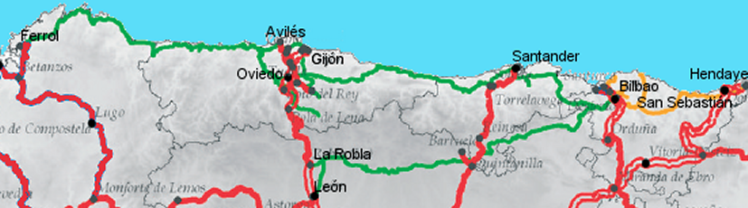
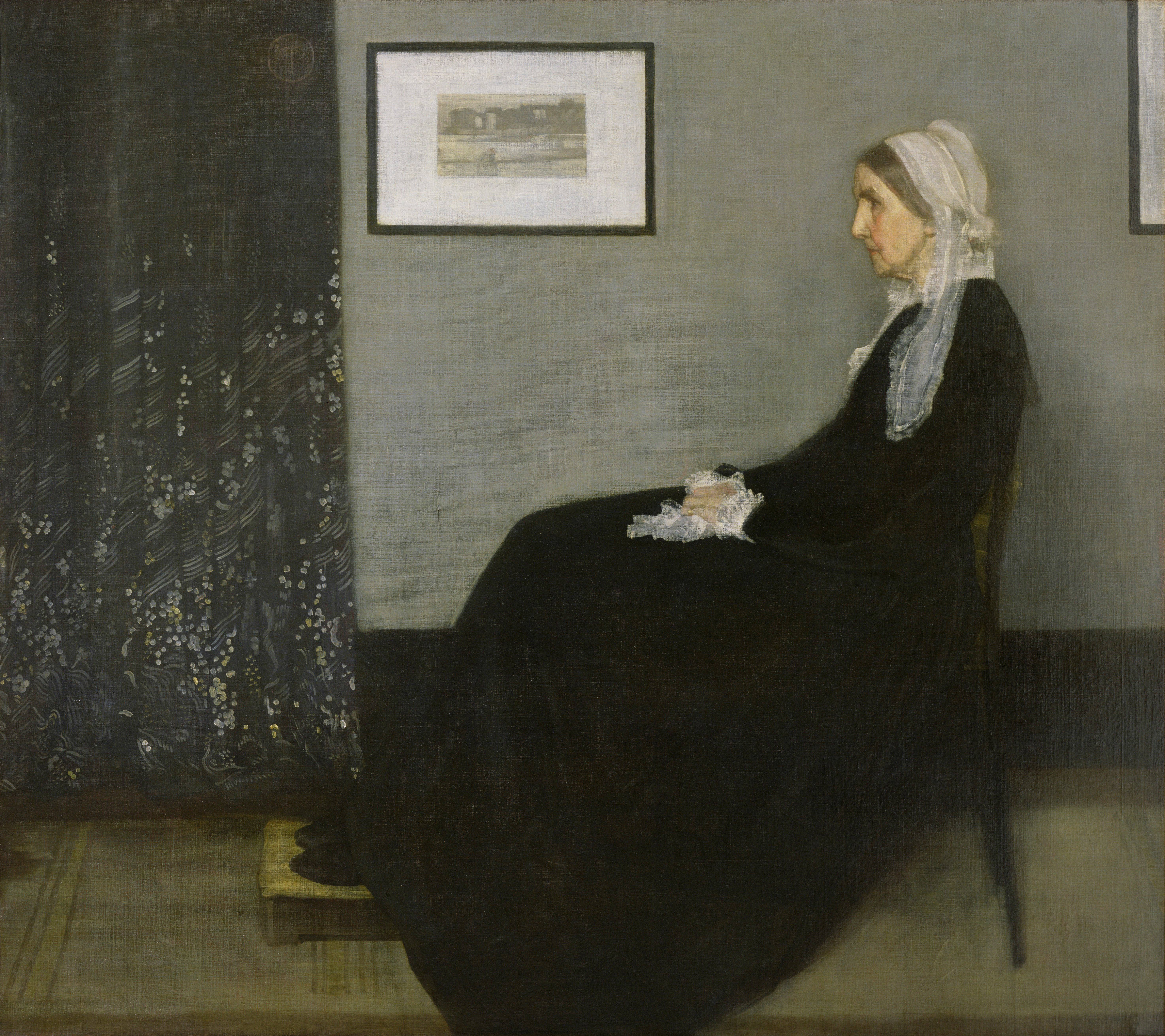
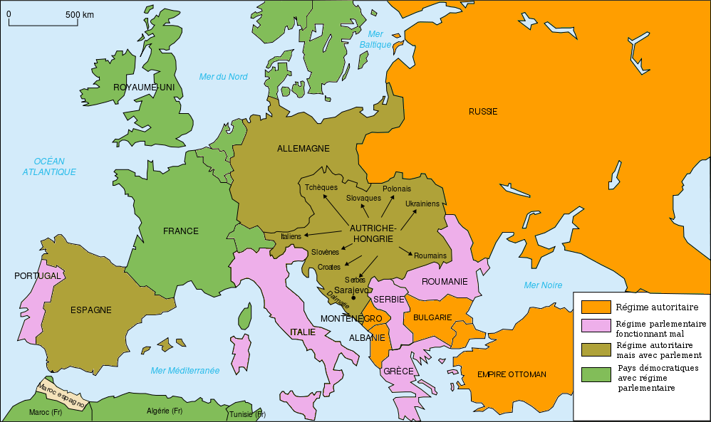
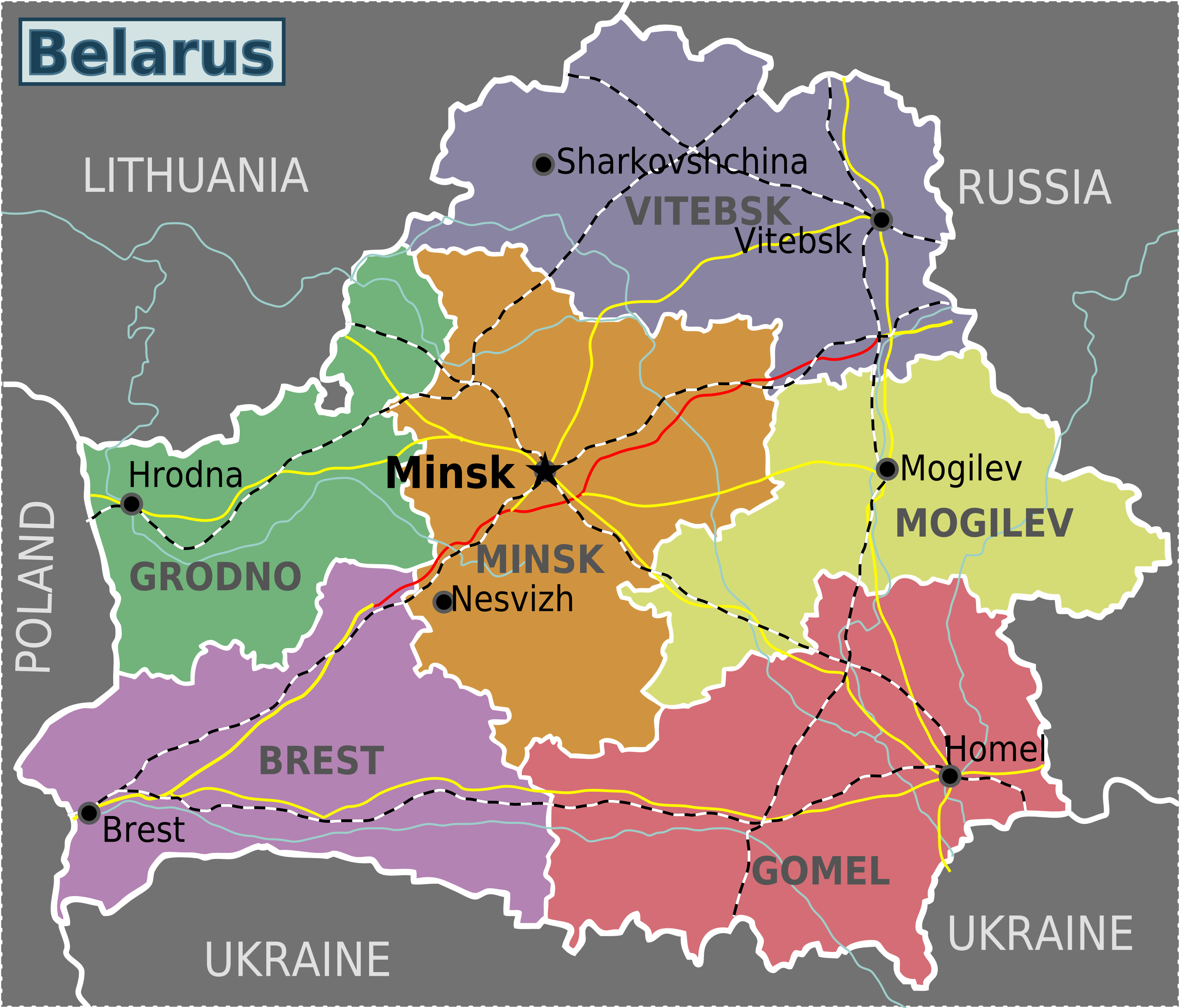
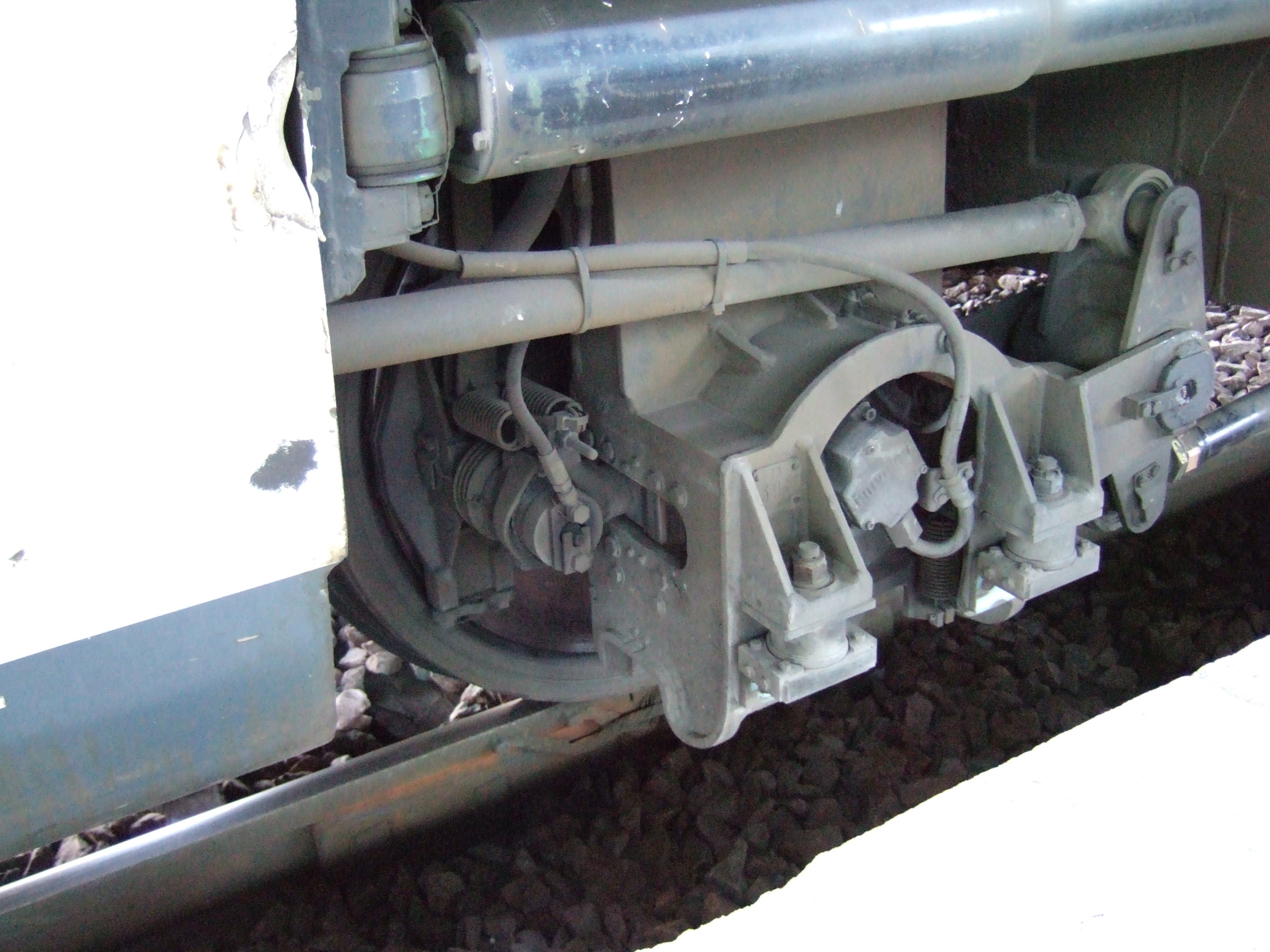
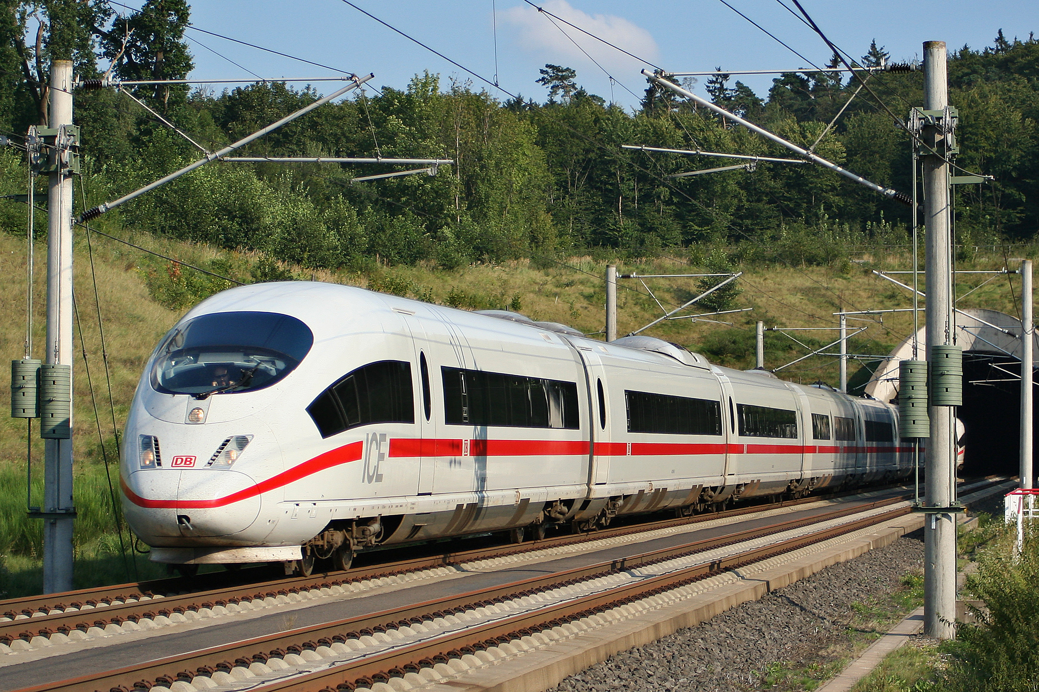
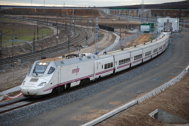
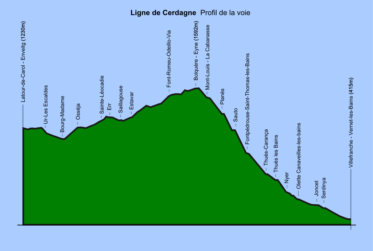