|
Reflections 2024
Series 8
August 25
2020s Catch-Up – Hudson Circuits I – Hudson Yards – The Vessel
| | Catching Up We've completed discussing travel in the twenty-teens as per the Miami trip of November 2019 and are now confronted with voluminous online research notes and online pictures and maps covering the 2020s, specifically travels for the five years from 2020 to 2024.
Again I'll say the delay and backlog are due to going off on numerous tangents, such as about Agatha Christie, the Orient Express, and similar subjects. It was NOT the pandemic that caused it, it was just fun wanting to talk about other topics. But let's talk about the pandemic.
Covid-19's name lies to us. It started in Wuhan in December 2019—the month after the Miami trip--so it bears the number 19. But it hit most of the world in 2020. Thus the name doesn't indicate the worst Covid year as well as it should.
| | | | 2020 We know about all the illnesses and deaths, and won't go further into that. However, personally I was connected to two Covid deaths in 2020. The first was—quite ironically--my internist. I got a letter from his group practice announcing it and saying I should look for another internist within the practice, which I did. The other death came later—it was my first cousin Jimmy on my father's side.
I also know of two 2020 weddings that were postponed. One was a family wedding, and the other involved two friends one of which had immediate family in Germany that couldn't travel to the US because of pandemic restrictions. But in 2022, both these couples did get married.
As for 2020 travel plans: a carefully planned, scheduled, and booked trip on the Great Lakes had to be cancelled and postponed. Now this was two major changes back-to-back! In 2019 the Cuba + Caribbean trip was canceled (happily) because the Trump administration stopped US visits to Cuba, but I replaced that on the spot with the Miami-Key West-Miami Beach trip, and there was no loss in time. But when Covid nixed the Great Lakes trip in 2020, I could only take it apart piece by piece and hope to replace it in the future (I did, in 2022 and 2024).
| | | | | | The cancelled trip was to be by rail via Chicago to Milwaukee; rental car to eastern Wisconsin, then to the Upper Peninsula (UP) of Michigan to sail on Lake Superior; then a flight from there back to Chicago; then a cruise to Toronto; then rail back home. I canceled the cruise, and they did the right thing and gave me my deposit back. Blount did this despite then having to go out of the cruise business. The ship was to be the Grande Mariner, the same one I'd come down on the Erie Canal in 2016, but it and its sister ship were sold. The ship now belongs to another cruise line.
Getting back my Amtrak points was easy, as was canceling carefully planned hotel rooms and the rental car. I had to cancel the day trip out of the UP to Isle Royal National Park, which had been planned to physically sail, on Lake Superior (which the cruise omitted). But there was one irritation. I rarely fly short distances, but after driving north to the UP, I didn't want to deadhead and drive back south to Chicago, so, against perhaps my better judgment, I booked and paid for a flight on Delta. And Delta wouldn't give me my money back. They would only give a travel voucher for a Delta flight, valid for two years. What a scam! They were keeping my money (and that of many others) knowing that many if not most wouldn't end up using the voucher, especially compounded by the steep reduction of travel during the pandemic.
But following the pseudo-Latin principle of Illegitimi non carborundum, or Don't let the Bastards Grind you Down, I researched and booked a delightful three-night trip to Dearborn, Michigan (Ford Museum & Greenfield Village) in 2021 to use the voucher, almost to the penny, just adding to it the equivalent price of a sandwich. And I enjoy calling this Dearborn trip my "spite" trip. It was great fun, but it was instigated to spite Delta Airlines. More in the future.
As for the other parts of the canceled trip, as mentioned, in 2022 and 2024 I did two cruises and rail (rail 'n' sail) to replace the canceled trip. I rented a car to see (and really enjoy) eastern Wisconsin. I didn't replace going to the UP because this time, the 2024 cruise did include Lake Superior.
|
| | | | So does that mean that I had no travel in 2020? Not at all. I refer you to 2020/9 & 10. Both talk about Pandemic Travel day trips locally, and to the World Trade Center in particular. 2020/10 hones in on the adjacent Calatrava's Oculus. But scroll down to the section called Birthday in the Ironbound. It first talks about the PATH route to New Jersey and rail terminals in general, so keep on skipping to the sections called "Harrison" and "Newark"; then "Going to Dinner", and "The Ironbound", the Portuguese neighborhood. It was my one night away in 2020 and was great fun. | | | | | | I should explain again about these one-night trips. When Marriott took over the Starwood system and blended all the points together, they added one additional feature. Every year, when your credit card is renewed, you get a Free Night Certificate available in many of their hotels. You not only don't pay cash for this night, you don't pay Marriott points, either. I've used every single one of the six I've gotten since I got involved with Marriott, in either of two ways.
Three I actually used when on a trip. In each case, I used the Certificate for one night, then points for the other, as follows: 2019 Courtyard Miami Downtown; 2022 Courtyard Buffalo (NY) Canalside; 2024 Delta Hotel Thunder Bay (Ontario).
But in the three other years, I couldn't work the certificates into a trip, so I looked around locally, and found a treasure trove of hotels to select from right across the Hudson in New Jersey. Thus I made these into one-night trips away, as follows: 2020 Element Hotel, Harrison (for adjacent Newark's Ironbound); 2021 Port Imperial, Weehawken; 2023 Westin Jersey City Newport in the Newport neighborhood of Jersey City.
Now two of these have already been written up, 2019 in Miami, and 2020 in Harrison (for Newark).
The 2022 Buffalo and 2024 Thunder Bay stops were each part of the two Great Lakes trips.
The 2021 Weehawken and 2023 Newport/Jersey City stops were each part of the one-night Hudson Circuit trips.
One footnote here. When dealing with large entities, like Delta Airlines—or Marriott Hotels—just be careful. For instance, each year when my credit card renews in March, Marriott informs me I'll be getting a Certificate, valid for a year. But the Certificate is never ready until at least two months later, in June sometime, meaning its practical validity is only 10+ months. Now if I'm traveling in the summer, I like my bookings all lined up in a row, and don't want to wait for the Certificate—this was the case both in Buffalo and Thunder Bay. So I made a two-night reservation on points only, and when the Certificate became available, I phoned Marriott and asked for the Certificate to be substituted for one of the nights, and for those extra points to be returned to my account, which has always been done. Once again, Illegitimi non carborundum.
|
| | | | 2021 to 2024 That leaves us with the four travel years from 2021 to 2024. We'll be discussing them with similar trips grouped together, as follows:
2021 (2023): I did two one-night Hudson Circuits, a crazy, crazy major one in 2021 to Weehawken, and a much smaller one in 2023 to Newport/Jersey City. But then there was also the day trip in Poughkeepsie back in 2010 that should also be referred to.
2021: We'll then do the three-night trip to Dearborn (Ford Museum & Greenfield Village) later in 2021.
2022 (2024): This is the Great Lakes Rail 'n' Sail, in two parts.
2023: Out of the clear blue sky a rather inexpensive cruise back to Bermuda (after two earlier visits) developed late in this year, and I grabbed on to it.
That's it to catch up with the 2020s. But there's more—if I ever get to it. Hidden away in a separate file are about five sets of extensive notes, pictures, and maps that do not connect with travel in any specific year and will have to wait to be written up until afterward. Included are these three: I recently mentioned in Miami Beach that I had material to do an extensive discussion of La Cage aux Folles/The Birdcage in ALL of its many iterations; I have notes on airships and blimps, including Goodyear, the Graf Zeppelin, and the Hindenburg; I also have notes on Georgia and the Caucasus. So much still to publish! So let's start.
| | | | Hudson Circuits In 2021 I did a Mid-Manhattan Hudson Circuit and in 2023 a Lower Manhattan Hudson Circuit, each for one night away and each involving rail 'n' sail. But back in 2010, five of us had done a Poughkeepsie Hudson Circuit upstate, all on foot. It was not overnight, just a fun day trip, but it deserves to be cited here. By pure coincidence, all three circuits of the river were done counterclockwise. | | | | Poughkeepsie Hudson Circuit If interested, go to 2011/8 and scroll to the very end. The heading "Poughkeepsie Bridge" explains the origin of the Walkway Over the Hudson, and the following heading, "Poughkeepsie Hudson Circuit", gives the details of five of us doing just that. But I can also summarize it here.
As for the POUGHKEEPSIE RAIL BRIDGE: We know that northeastern US cities line up along the coast, by road or rail, to form what is known as the Northeast Corridor rail route, which connects Washington, Baltimore, Wilmington, Philadelphia, Newark, New York, New Haven, Providence, and Boston. But before the Pennsylvania Railroad built its tunnels under the Hudson River to reach Penn Station in Manhattan, the Hudson River remained a major obstacle.
For passengers coming from Boston and the north headed for NYC, it was a one-seat ride. But for those coming from Washington and the south headed for NYC, the train line ended in NJ at the Hudson shore, and everyone had to transfer to a ferry to Manhattan. At the time, nothing could be done about that inconvenience.
https://kids.kiddle.co/images/thumb/4/4c/Poughkeepsie_Bridge_Route_map.jpg/300px-Poughkeepsie_Bridge_Route_map.jpg
But what about thru passengers who were not headed for NYC? Why should they have that inconvenience? For that reason, a rail bridge was built at Poughkeepsie, opening in 1889—see above map--and trains between Washington and Boston would cut an arc that bypassed NYC for a one-seat ride—so did freight. The bridge was heavily used. In 1943 during WWII, it carried up to 3500 train cars a day. But in 1974, a fire damaged it and it was closed, and anyway, its reason for being disappeared after the direct tunnels into Manhattan were completed in 1910, as well as other infrastructure. But then in 2009, the linear park known as the Walkway over the Hudson opened in Poughkeepsie.
https://walkway.org/wp-content/uploads/2020/06/Loop-Trail-Insert_Poughkeepsie_Illustrated-map-FINAL-FOR-SPRING-2019-scaled.jpg
Thus, five of us did a POUGHKEEPSIE HUDSON CIRCUIT (pə.KIP.si) the following spring, in 2010. It was a group walk with nephew Greg, his wife Rosemary, and family friends Audrey and Jane. To do the circuit, we did the Loop Trail (above) rather than crossing over, then backtracking. The trail involves a complete circuit, which we enjoyed. I arrived by train (click to see the Poughkeepsie station). Greg & Rosemary drove north from Flushing, Queens, and Audrey & Jane drove south from Catskill NY. We met at the station and walked the irregular rectangle: the north on the upper part of the east leg in Dutchess County, west across the Walkway, south on the Ulster County side, east across the Mid-Hudson Bridge, then north again on the lower part of the east leg, back to the station. We then all went to dinner, after which they dropped me off back at the station and we all went our ways. (For pictures of and from the Walkway and other details, see the very end of 2011/8.)
| | | | Mid-Manhattan Hudson Circuit: NYP to River I think that people who don't follow rail history are unaware of the major changes that took place in NYC at the turn of the 20C. Thru rail service via NYC was instigated with the building of the tunnels under the Hudson River, and other infrastructure improvements, including under the East River. This meant that the ride was simplified for passengers for NYC coming from the west and south, and also for thru passengers, removing the importance of the upstate route via Poughkeepsie.
https://www.bloomberg.com/graphics/2018-amtrak-sea-level/img/2018-amtrak-sea-level-facebook.png
https://static01.nyt.com/images/2014/01/09/nyregion/metronorth-map/metronorth-map-superJumbo.jpg
The first link shows the modern Amtrak connections thru NYC. Trains from Washington and intermediate stations (notably the higher-speed Acela) stop at Newark (Penn Station) then cross under the Hudson to New York Penn Station (NYP; Grand Central Terminal is GCT). There is no longer a need to instead continue to upstate New York at Poughkeepsie to cross the Hudson. From NYP the route crosses Manhattan, passes under the East River, then crosses part of Queens and the Bronx to continue to New England and Boston. Note that the Empire Service instead continues north out of NYP to Poughkeepsie, Albany, and beyond. This was the former route of the Hudson River Railroad. South of NYP the Highline Park replaces the southern part of that former route.
I've included the second map to show further details. From NYP via Queens and over the Hell Gate Rail Bridge thru the Bronx, then north to New Haven and beyond. (The actual purpose of this map is to propose making the section in black a new Metro-North route from New Haven down to NYP—a good idea.)
https://www.dattner.com/wp-content/uploads/2020/05/7Line_SitePlan.jpg
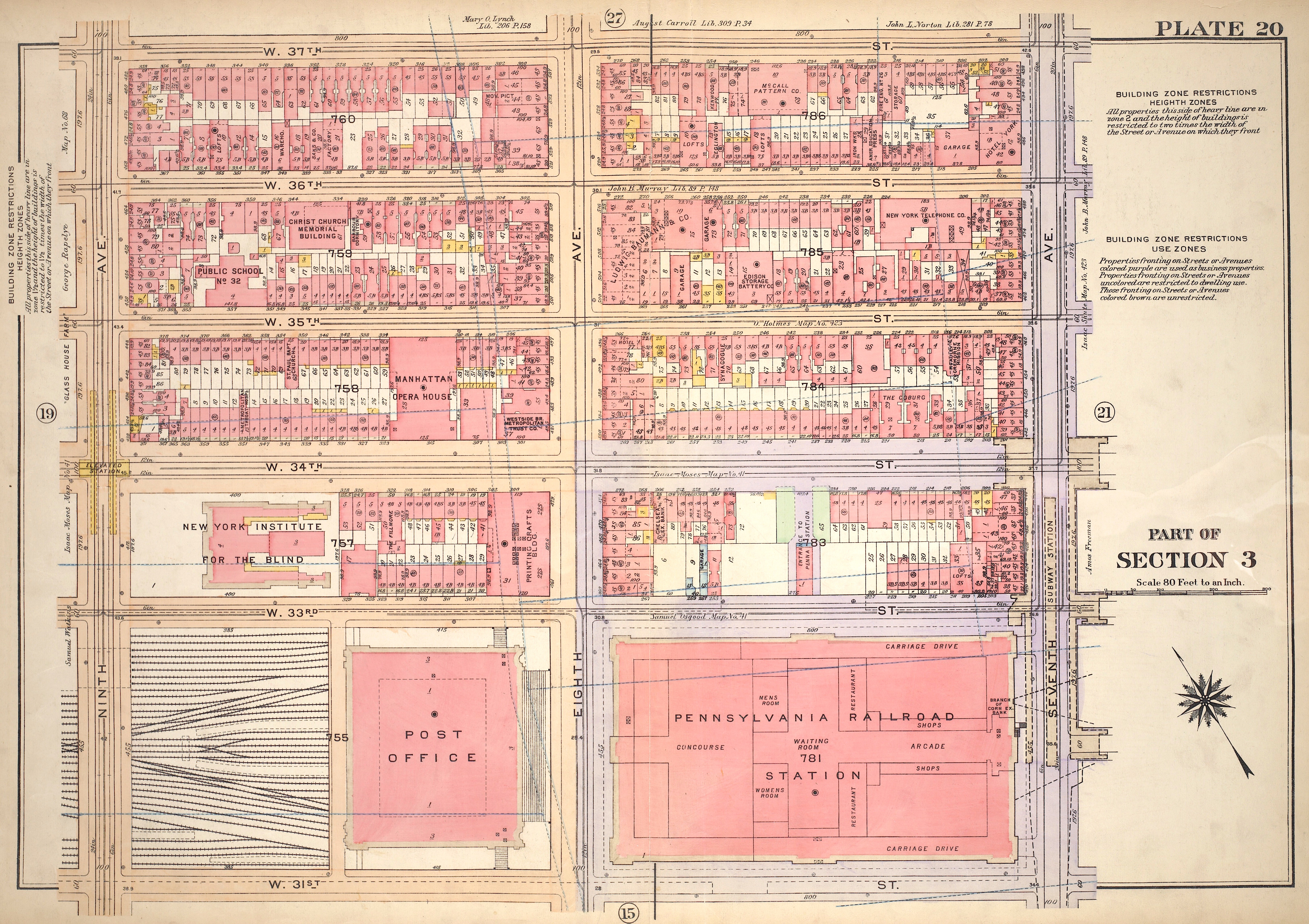
That was the large view. The more compact view within Manhattan involves NYP itself, along with the ancillary areas to the west as shown above (keep this "main map" for a bit).
The area involved is a rough rectangle in the West 30s. Unfortunately, no streets are named on the map. The north side of the rectangle varies between 34th Street (the wider street on the map) and 33rd. The south side varies between 31st and 30th.
Thus, on its east end our rectangle runs for only two blocks, 33rd down to 31st, while at the west end, it's four blocks, 34th down to 30th.
Now let's consider that this transportation rectangle as being further subdivided into five superblock squares, separated by the major avenues from 7th to 12th Avenues. Let's check out these superblocks.
| | | | Penn Station (NYP) The superblock furthest east includes NYP itself facing 7th Avenue and running west to 8th. Note that today, NYP is claustrophobically underground and suffers under the burden of Madison Square Garden on the west side and an office building on the 7th Avenue side. This 1920 plan shows its original layout, filling the superblocks between 7th and 8th. Click to locate the Main Waiting Room and Concourse.
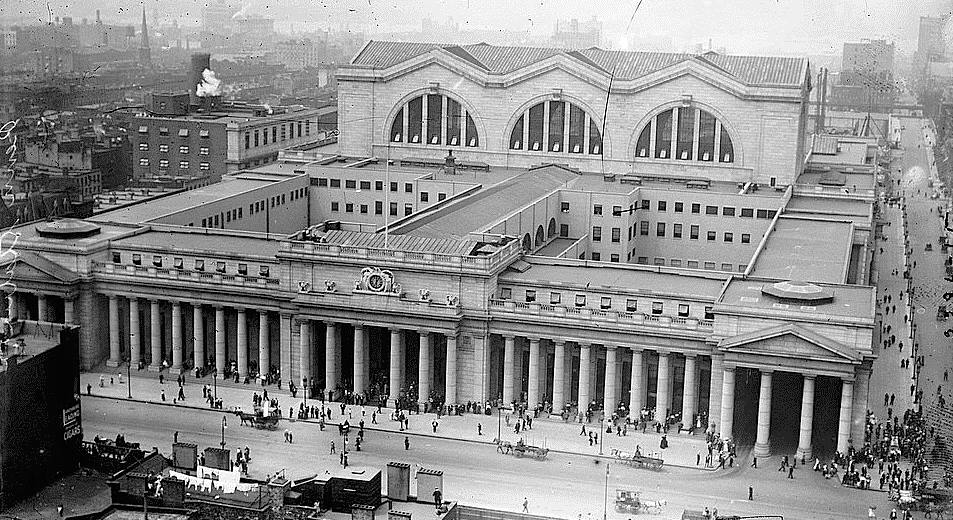
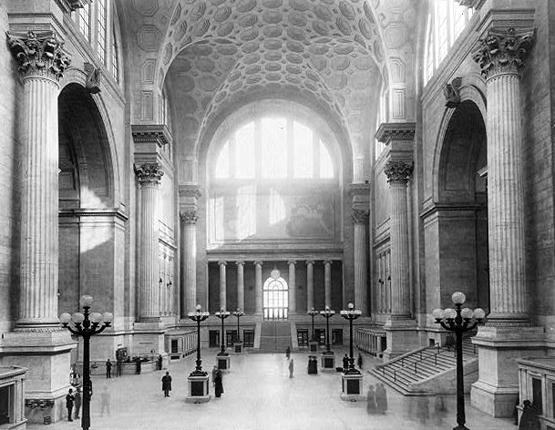
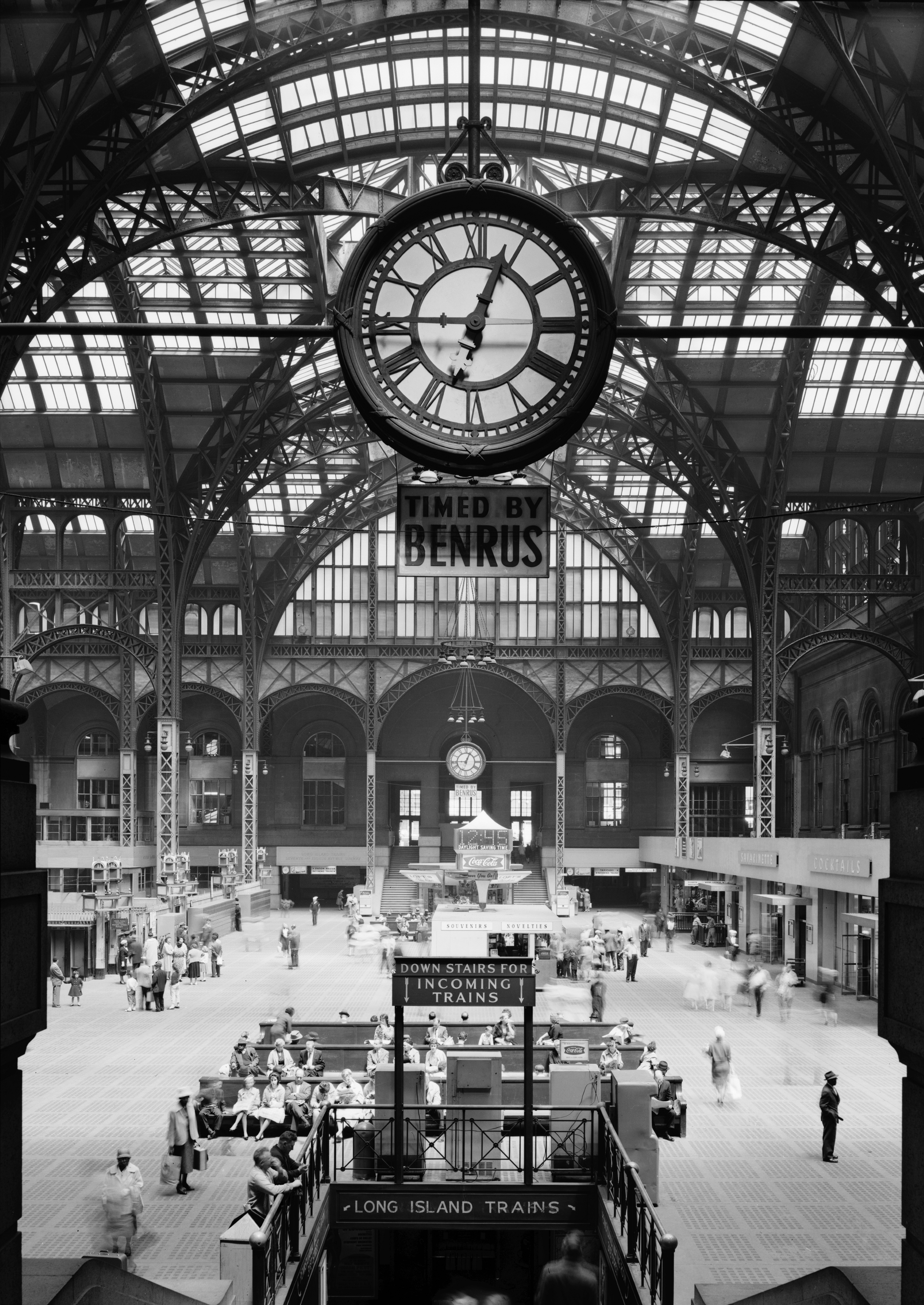
When it opened in 1911, this was the magnificent Pennsylvania Station on 7th Avenue (also showing 33rd Street on the right). Here is the expansive Main Waiting Room, which, as the map showed, ran the station's entire length for the two blocks between 31st to 33rd Streets. It was noted for being inspired by the Baths of Caracalla in Rome. It was 46 m (150 ft) tall and is comparable in size to the nave of St. Peter's Basilica in Rome. It could engulf a 15-story skyscraper.
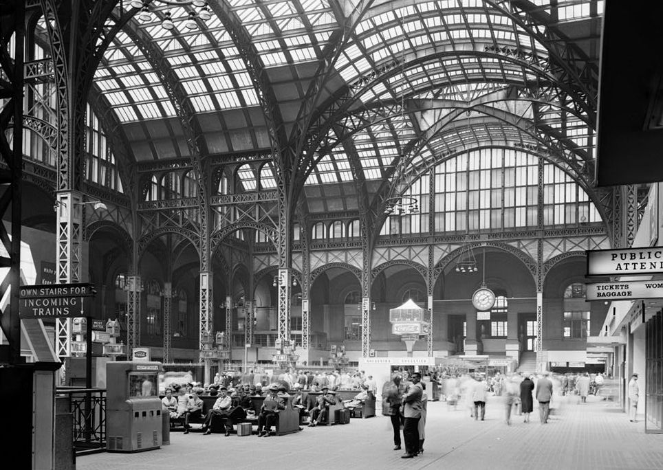
Nearby was the Main Concourse. It was covered by glass vaults that were held up by a plain steel framework. Architect Charles McKim of McKim, Meade, and White wanted to give "an appropriate transition" between the decorated nature of the Main Waiting Room and the utilitarian design of the tracks below. This is the Concourse as seen straight on from the south (click), showing its full two-block length, and its clocks.
But the powers that be thought it a good idea in 1963 to tear most of it down, leaving the track area and concourse below street level, and parasitically impose the fourth iteration of Madison Square Garden on top of it. Its destruction was the catalyst that sparked the entire landmarks preservation movement, and thus later saved Grand Central Terminal, which was about to be similarly destroyed.
But today, NYP is in transition. The changes made so far involve that 33rd Street (north) side on the 1911 picture, where that one block is being transformed.
https://images.globest.com/contrib/content/uploads/sites/409/2019/05/6.-Penn-Station.jpg
I like to call what is left of the old Pennsylvania Station as existing on the "basement level" of the office building and MSG above it. In this view under 33rd Street looking south, the "lower basement level" has the platforms and tracks, and the "upper basement level" has the concourse connecting all ticket areas and waiting areas. You also see the escalator connecting this area via a very unusual kiosk to 7th Avenue on the left, under which, the 7th Avenue subway is visible.
https://new.mta.info/sites/default/files/2023-04/Banner.jpg
https://thumbs.cityrealty.com/assets/smart/736x/webp/9/90/90a8cf3d5f2d5e9310ac1dc01a5b39447da1a6f5
This first link shows in detail the concourse area down below 33rd Street as it's being converted into an updated concourse. Behind us it offers direct entrance to the LIRR, and beyond to Amtrak and New Jersey Transit. But this view looks east, and those escalators (Photo by MTAPhotos) lead up to NYP's new East End Gateway on 7th Avenue, where, coming home from a rail ride, I get my M20 bus. The second link is most likely an artist's rendering of the Gateway at what used to be a block of 33rd Street. Note the highly unusual shape of the entry/exit kiosk. It leans forward and is exotically curved.
https://www.architecturalrecord.com/ext/resources/Issues/2021/08-August/East-End-Gateway-04.jpg
Above is the spectacular view coming up the escalator. Upon exiting and turning back around, this is the view of the kiosk, (with construction in 2021) as long as you're looking straight on (Photo by CaptJayRuffins).
https://www.gw-news.eu/sites/default/files/styles/aurora_default/public/aurora/90749.jpeg?itok=WlsXF9yN
https://c8.alamy.com/comp/2E129K2/new-york-penn-station-east-end-gateway-33rd-st7th-ave-entrance-to-long-island-railroad-empire-station-complex-new-york-2E129K2.jpg
But look at the startling optical illusion you get if you step to the left or to the right. Since it leans forward, it looks like it's leaning in the opposite direction from where you are!
If you are unfamiliar with the rise and tragic fall of Pennsylvania Station, you might want to look at these videos to bring you up to date. The first one, New York's Lost Marvel, is longer (13:13) and more comprehensive. The second one, Penn Station Reborn, runs for 4:55. It's more concise, and give a lead-in to the reason-for-being of Moynihan Train Hall which "will be built" (but it already is). It also ends with the hope that the old station could still be rebuilt, a great idea, tho nevertheless unfortunately impractical.
| | | | Moynihan Train Hall Go back to our main map. Behind NYP and across 8th Avenue, running to 9th, is Moynihan Train Hall (early on it was referred to as a station, but it really just serves as the train hall for NYP). This is the second square within our large rectangle. Let's look at the 1920 map again to see that originally, McKim in 1914 had built the city's Main Post Office in the Farley Building over the tracks to receive and send intercity mail via rail in its basement. Just as NYP was for people, the Farley PO was for letters, both using the tracks and platforms below--because Farley was an adjunct to NYP, the train platforms under NYP were always extended under 8th Avenue and under the Farley Building to also serve it.
Moynihan Train Hall is an expansion of NYP, from the current small spaces to an atrium area behind the PO and no longer needed by it. The annex provides new access to most of Penn Station's platforms for Amtrak and Long Island Rail Road passengers, serving 17 of the station's 21 tracks. Platforms serving the southernmost four tracks, used by NJ Transit, could not be extended to the new facility, and so NJT remains limited to the original NYP.
The hall, which opened at the start of 2021, is named after Daniel Patrick Moynihan, the US senator from NY who had originally championed the plan. It's especially noteworthy that the Farley building's Beaux-Arts exterior resembles that of the original Penn Station, since both buildings were designed by McKim, Mead, and White. This is the façade of the Farley Building, with Moynihan (not visible) behind it (Photo by Epicgenius). The steps continue to lead up to the PO, and the 8th Avenue entrances to Moynihan are seen on either side (I use the south one on the left, just across from my bus stop).
The $1.6 billion renovation restored the Beaux-Arts Farley Building, a designated landmark, and developed the central atrium with a glass roof for the Train Hall.
https://moynihantrainhall.nyc/wp-content/uploads/2021/02/2023-10-04-MTH-Web-plan-Station-Overview.jpg
To make sure you continue to see the relationship between our first two squares, review the above sketch. The white lines show where the office building has replaced the front of Pennsylvania Station above ground, while the circular Madison Square Garden (4th iteration) has replaced the rest. You can see where that block of 32nd Street has been repurposed as a linear concourse, and the kiosk is also shown, along with an alternate station entrance from 34th Street. The Train Hall is behind the remaining part of the post office. NJ Transit remains inside NYP, while Amtrak is now exclusively in the Train Hall. The LIRR is reachable from both buildings.
NYP has 4 entrances on the east side, and two on the west. The Train Hall has five, but I suspect the two on 8th Avenue are most accessible to street traffic and get more use. You see the northbound bus line indicated on 8th. I get off at 31st Street. For NJT to Newark Airport I enter NYP on the NE corner. For the LIRR and Amtrak, I enter Moynihan on the NW corner (Photo by ajay_suresh). Coming home from anywhere, I always exit via the kiosk to 7th Avenue where my southbound bus runs, tho I occasionally take a taxi home.
The main part of Moynihan Train Hall consists of a passenger concourse underneath a 28 m (92 ft) glass skylight (Photo by D Benjamin Miller). This is a closeup of the clock, which has four faces roughly 4 by 2 meters/yards in size (Photo by gsz). The clock was inspired by the machined angles found in designs from the golden age of railroad travel and evokes the best of Art Deco. Now go back to the first concourse picture and click. This view looks south, indicated by three things. On the right, is the sign showing the south entrance from 31st Street. On the left is the sign showing "my" southeast entrance from 8th & 31st. But most important is the sign in between, indicating that the Amtrak Metropolitan Lounge is in the mezzanine above the sign, for sleeping-car passengers.
I've been to the Amtrak lounges in Washington, Chicago (both old and new), and the old one in NYP, and this is by far the most comfortable and most generous with food freebies. Click to inspect the lounge interior (Photo by Richard N Horne). The complimentary serving area is almost a cafeteria, specializing in sandwiches and pastries, along with beverages. They're very generous. Note the windows on the left.
https://imgs.6sqft.com/wp-content/uploads/2019/01/24115738/Metropolitan-Lounge-Moynihan-Train-Hall-3.jpg
This is an artist's sketch of the balcony outside those lounge windows overlooking the entire expanse of the Train Hall. It's very comfortable. I only had occasion to use this new lounge once, in 2022 before taking my sleeper to Chicago on my first Great Lakes rail 'n' sail. It's well worth coming early to get to enjoy the lounge.
The Moynihan Train Hall has been criticized for its lack of public seating in the Concourse. Other than the lounge for first-class passengers, only the ticketed waiting areas contain seats. Passengers in the main hall sometimes sit on the floor while waiting for trains, which security officers sometimes prohibit. Officials have stated the lack of seating is designed for improving the "circulation" of people, but critics have argued it is hostile architecture to keep away the homeless. It is quite noticeable how many people are sitting on the floor.
The Hall's lack of large central signage, and the fact that it did not actually increase Penn Station's track capacity, have also been criticized.
| | | | Manhattan West The first two squares together cover the principal transportation story of the area. The remaining three squares have traditionally been secondary—they were all train yards for storing trains not in use, below street level and open to the sky, and remote from the business center. Consider these yards as a "garage" behind the "house". All together they've been known as the Hudson Yards, in other words, Penn Station's remote train storage yards lying close to the Hudson River.
https://s3-prod.crainsnewyork.com/styles/1152x647/s3/4.jpg
This view gives an idea of the separation in importance. While there are train tracks below all five squares, the three westernmost squares have always been the Hudson Yards. You'll notice that the third square, between 9th and 10th Avenues, is particularly ignored, and I've had difficulty finding its early history. The tracks might have been covered over years ago and built on, appearing as just another city block—I just don't know. But as for its more current history, it begins to emerge from the shadows.
Brookfield Properties, with origins in Toronto, is a real estate development company with vast holdings. I first became aware of it when it moved into my neighborhood, taking over what had been the World Financial Center in Battery Park City (adjacent to the World Trade Center) and renaming it Brookfield Place (tho people often still use the old name). This development includes the iconic Winter Garden, which was damaged during Nine Eleven, and later repaired.
https://newyorkyimby.com/wp-content/uploads/2016/08/mw-neighborhood.jpg
To my great surprise, the third superblock, whatever it had been earlier, in recent years has become a mixed-use development by Brookfield Properties called Manhattan West (see above). It was built as part of the much-reported Hudson Yards Redevelopment in squares four and five, but has remained more in the shadows. The project, which opened in 2021, consists of six buildings: four office buildings (in blue), One and Two Manhattan West, the Lofts, and Five Manhattan West; the Pendry Manhattan West Hotel (in gold); and the Eugene apartment building (in rust). Building One is 303 m (995 ft) high and is one of the tallest buildings in NYC.
It also includes Magnolia Court (in green), a 1 hectare (2.5-acre) pedestrian plaza, which is open to the public. The project was built on a platform over Penn Station tracks between 31st and 33rd Streets, running from 9th Avenue to 10th, putting it right between Moynihan Train Hall and the more famous Hudson Yards Development.
It will shortly become apparent that I have great antipathy to the Hudson Yards Development to the west, so I was glad to find out that Justin Davidson, in a magazine article, compared Manhattan West favorably to Hudson Yards, writing that the Brookfield development "feels like a corner of New York conceived with actual human beings in mind" while the Hudson Yards Development "has aged from a shiny new space station to a disconsolate one". While I've visited the other squares, I've not seen Manhattan West, but am glad to see this positive review.
https://www.mas.org/wp-content/uploads/2017/12/manhattan-map-with-railines-to-penn-station-pano.jpg
This is another map where part of it has to be ignored. Disregard what you see in red. It's just a highly controversial suggestion of how more tunnels under the Hudson should serve a new Penn Station South station. Otherwise it's good in showing all the trackage in our area. Let's concentrate one more time on Manhattan West. You can see how a small local street called Dyer Avenue (not named here) runs from 30th Street north (to 42nd) to accommodate Lincoln Tunnel traffic between 38th and 39th Streets. While it divides Manhattan West in two, it's buried unobtrusively in a tunnel.
Otherwise, this is the clearest map showing east-west rail trackage across Manhattan. It also shows what has happened to the former Hudson River Railroad route. To the south, it's now the High Line park in green, wrapping around Hudson Yards, but with a short spur going east. North of Hudson Yards, you see the former Hudson River Railroad cut which today's trains use from NYP as the Empire Connection, the route north to Albany. You can see the track looping right out of NYP.
An update on this map is that it says the 34th Street subway station is planned to service the remote Hudson Yards Development, but as our main map shows in purple, it's long been completed, and I visited it earlier, as below.
| | | | | | In October 2016 I took the trip out of Montréal and down half of the Erie Canal, then the Hudson River. We docked in Chelsea's Meatpacking District and had one day "in town". Some went on a Manhattan tour, some locals went home, but I decided to become a one-night resident of Chelsea and do my own thing, using Chelsea as my base. I'd walked the part of the High Line that been opened earlier, but this time I walked the entire length, from Gansevoort Street to 34th Street.
If you wish to review that visit, it's posted on 2017/8, but I'll summarize it here. Otherwise, you can scroll WAY down to the bottom to the heading "High Line", which tells about that walk, ending in the section "Hudson Yards", the development of which was then still under construction, with little to see.
But after that, at the very end, are the entries "Hudson Yards Station" and "Depth", explaining how very deep the new station is. We point out how the 34th Street/Hudson Yards Station is the third deepest in NYC, coming in at 38 m (125 ft) deep. There are nine escalators at this station, but also a pair of custom-made inclined elevators installed at the entrance to the nearby (southern) end. But what's unique about the inclined elevators here at 34th Street is that first, they're entirely indoors, unusual enough in itself, but second, that they go way down below sea level! They slope at 27° and are 52 m (172 ft) long (measuring diagonally), 24 m (80 ft) high, and move at 30 m (100 ft) per minute, taking less than two minutes end to end.
Check our main map again. On that visit I took the subway extension (in thick purple) to get from this remote area to Times Square, where I could connect to return to the ship, so I did get a chance to experience this new station, and its inclined elevators.
https://i0.wp.com/vanmaps.com/wp-content/uploads/2019/11/sq_penn.png?resize=680%2C680&ssl=1
One last map showing subway convenience, or lack thereof. The yellow lines in Herald Square are a block from NYP (I've walked that connection); the red line is in front of it. The blue lines are behind it, and in front of Moynihan. It's now also clear how remote the Hudson Yards Development is, to the extent that the (purple) #7 train from Flushing to Times Square/42nd Street had to be extended further west and south to 34th Street. It also shows how the line overshoots Hudson Yards, not only for trains to reverse direction, but also for possible future expansion.
|
| | | | Hudson Yards Development The main map shows the two squares where the Hudson Yards Development proper is located (distinct from Manhattan West, which is also above the Hudson Yards).
https://media.architecturaldigest.com/photos/5c893eb5fd05a62d5ad09aa5/master/w_1600,c_limit/Acr988333841344-185584.jpg
This is a detailed view from Architectural Digest of the Hudson Yards Development (often shortened to just "Hudson Yards"). It shows both the Eastern Yard from 10th to 11th Avenue, which has been built, and the Western Yard, from 11th to 12th, which has not been built. These are the final two superblock squares of the five we've been studying.
As you see, the Eastern Yard is larger, running from 34th Street down to 30th, while the Western Yard only runs from 33rd to 30th. Again, 11th Avenue continues to divide the two.
| | | | | | I will now say again that, quite unusually regarding places visited, I'm antipathetic to this Development and am not pleased with it, much of my frustration aimed at the developer, Related Properties, and its chairman Stephen M Ross. For that reason, I'd happily see the Western Yard either remain as it is, open to the sky as a train yard, or, better, have a platform built over it and made into a park. If it is built on, I'd hope the buildings would be lower and the development less massive and overwhelming than that in the Eastern Yard, but I don't have high hopes where money is to be made.
Having walked the High Line on the 2016 visit, I know how nice the view is from the western side of the High Line over the West Side Highway/12th Avenue to the river and the New Jersey side, and more park land would be in the public interest, but I doubt that will happen. Too much money is at stake.
https://manhattanmap360.com/img/1200/manhattan-streets-map.jpg
We should also clarify by following on this above map what is meant by the double name West Side Highway/12th Avenue.
The West Side Highway in Lower and Mid-Manhattan is a boulevard that takes (rather unbelievably) three alternate co-names. It's also called West Street from Battery Park City (my neighborhood) north to the Meatpacking District. Here (click), Tenth Avenue takes off at a point between Horatio and Gansevoort Streets and continues north.
The West Side Highway is now also called 11th Avenue (!) up to a point just below 22nd Street, where 11th Avenue proper also takes off to the north. After that, the West Side Highway is also called—what else?—12th Avenue! It keeps this alternate name up to 72nd Street, where it then becomes the Henry Hudson Parkway.
|
| | | | Eastern Yard Since it was built, the Eastern Yard seems to have been the only thing people understand as being the Hudson Yards Development, so we'll concentrate on that. Before we discuss our detailed map above, let's look at an early aerial picture, the one I used for the posting about my short 2016 visit via the High Line. This is the view of Hudson Yards taken the previous year, in 2015, when it was still under construction (Photo by William John Gauthier). We're looking east from the river—the circle is Madison Square Garden imposing itself atop NYP. Closest to the river we see the Western Yard, open to the sky as it still is today. Beyond 11th Avenue crossing the yard we see the Eastern Yard, partly built over, but also still partly exposed. Note the scale of neighborhood buildings. On the right is 30th Street, which the High Line enters in a curve (click) to encircle the yards. Again, the best High Line views here are near the river, looking over the West Side Highway/12th Avenue. The High Line today then crosses 33rd Street, but peters out on 34th Street, the wide boulevard on the left, whereas the original Hudson River Railroad that ran along the High Line then would have turned left into the cut below street level leading north (not visible), today's Empire Route.
Related Companies LP is an American real estate company founded by Stephen M Ross with headquarters at 30 Hudson Yards. Related is the primary developer and major equity partner in the Hudson Yards project. In all, Related has developed or acquired more than $60 billion worth of properties of all kinds from California to Abu Dhabi to Shanghai. However, the company announced in July 2024 that Ross would be stepping down as chairman of Related. I'm not sad about it.
Now go back to our detailed map. This project is the largest private real estate development in the US by area. When both phases are finished, most of its 16 planned structures will sit on a platform built over the Hudson Yards, a storage yard for Long Island Rail Road trains. The as yet unbuilt Western Yard is planned to include residential and office space, plus a school, as our map shows. The completed Eastern Yard opened in 2019, three years after my quick 2016 visit and two years before my 2021 Hudson Circuit visit. It's centered on a public green space called the Public Square & Gardens, which continues into Hudson Park north of 34th Street.
In the Public Square is the Vessel, surely the most noteworthy--and notorious--structure in the complex, which acts as its visual centerpiece. Since it's sui generis (one of a kind; in a class by itself), a large part of these Circuit postings will be devoted to it, but later on.
Surrounding the Vessel on the platform are the Public Square & Gardens 2 hectares (6 acres) in size, encompassing 28,000 plants and 225 trees. Beyond the esthetic, the Public Square is a ventilation area for the rail yards below, as well as a storm water runoff site, allowing for the water to be reused. Because it's above an active rail yard, the Public Square is located over a cooling slab with 15 fans blowing air at 72 km/h (45 mph). There's also a rainwater storage tank that can hold 230k liters (60k US gallons, 50k imperial gallons). The entire platform is supported by 234 caissons.
STRUCTURES: The other structures include a cultural building called The Shed, an upscale shopping mall, and a number of skyscrapers that are offices, residences, and, notably, a hotel. As for the buildings, it's my assertion that the area is overbuilt—too many buildings, far too tall to have so many clustered together, and much too far from the central business district. I think Hudson Yards, out by the river, is an out-of-place attempt to imitate the very successful Rockefeller Center of the 1930s in more accessible central Midtown. I had the opportunity the evening of the visit to look back at it from my hotel across the Hudson in Weehawken, and it looks like a giant barnacle on the Manhattan shoreline, as opposed to the lower-rise neighborhoods around it.
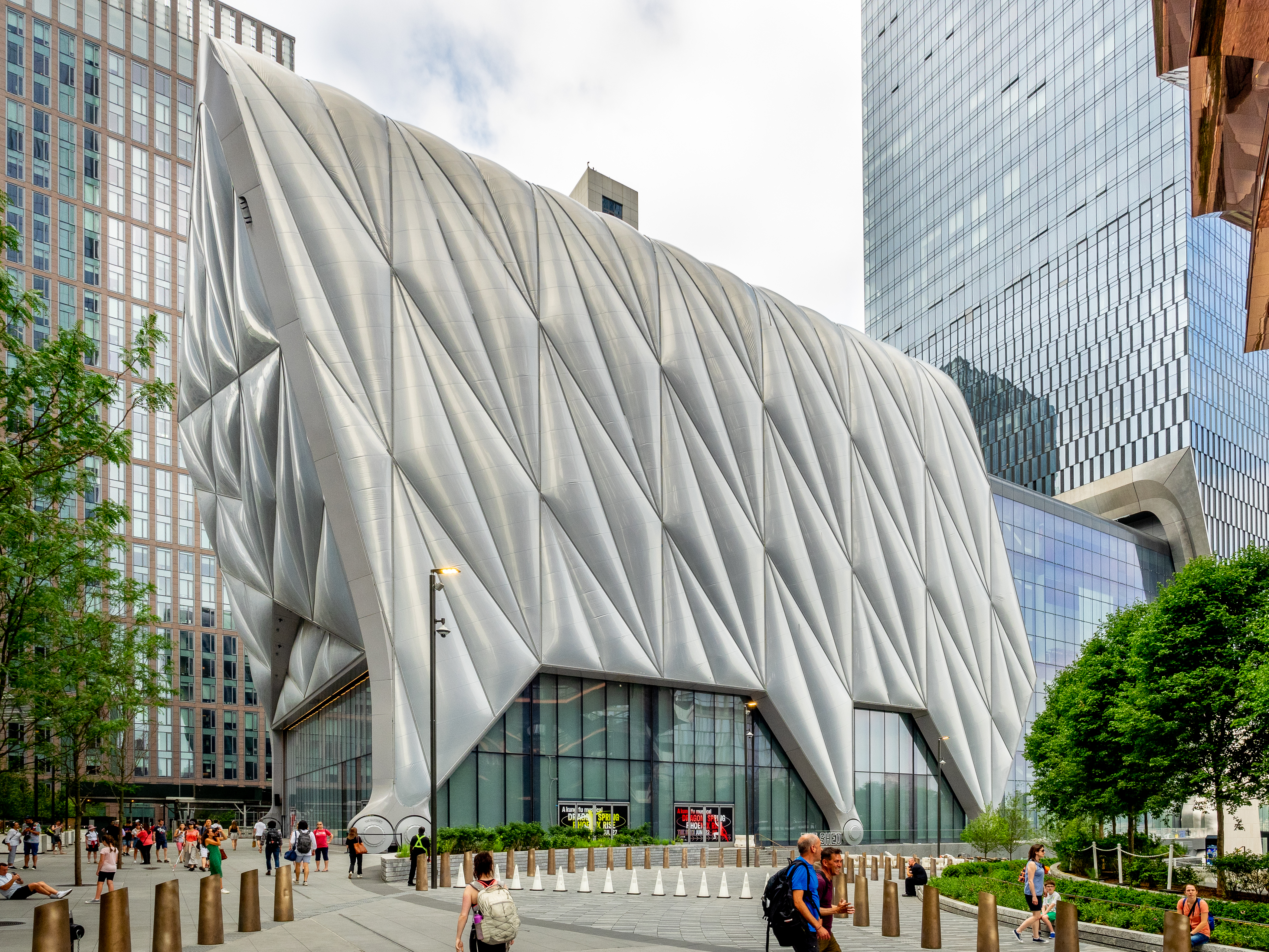
Let's start with The Shed (in green), a building that stands apart, not only because of its looks and operation, but because of its funding. It's also low-rise--36.6 m (120 ft) high--compared to the skyward buildings around it.
The Shed is an arts center. Its most prominent feature is a retractable "shell" that wraps around its roof and three of its façades. I've seen the somewhat gimmicky shell, but not in operation. The shell apparently pulls back to create a space, The McCourt, for large-scale performances, installations and events; a 500-seat theater; and two levels of exhibition space. The wraparound shell is made of an exposed steel frame, clad in a fluorine-based plastic, which has the thermal properties of insulating glass at a fraction of the weight. The shell can close and open within 5 minutes and when the shell is retracted, the open-air plaza becomes a publicly accessible outdoor space. The shell retracts on eight bogie wheels, each 1.8 m (6 ft) in diameter, powered by a total of six 15-horsepower motors (Both Photos by Ajay Suresh).
The Shed has received funds from a variety of grant-making foundations and government agencies, including the New York City Department of Cultural Affairs, the New York State Council on the Arts, and the National Endowment for the Arts. Perhaps for that reason, it's a bit stand-offish as regards the rest of the complex, since its main entrance faces south down below on 30th Street under the High Line (see map) and it's only some secondary entrances that are located in the Hudson Yards Public Square.
The Shed is physically attached to the residential building to its west. This is a short (0:29) time lapse YouTube video of The Shed rolling to close around the building proper.
Also relatively low-rise at seven stories is The Mall (in gold), whose address (not shown) is 20 Hudson Yards and is officially called, rather wordily, "The Shops & Restaurants at Hudson Yards".
https://leadingestates.com/wp-content/uploads/2018/08/Hudson-Yards-7-Stories-of-Retail.gif
It was built as an upscale shopping mall (click). Financially shaky Neiman Marcus signed on to become the anchor tenant, occupying the top three levels and a quarter of the mall (in pink above). Three-quarters of the space was devoted to retail, including 20 restaurants (in gold) and 100 shops (in blue). Fairway, a locally based grocer, had a store in the lower floors. American chef and restaurateur Thomas Keller opened his second restaurant in NYC, called the TAK Room (his initials). Other notable tenants were Dior and Chanel, with a Fifth Avenue mix of shops such as H&M (Swedish), Zara (Spanish), and Sephora (French) below them. But this has changed—see below.
| | | | | | As we proceed, I'll be quoting the two friends I know who have been to Hudson Yards, Simi Horwitz, who came with me the sweltering day of my visit (reason why, to come) to the top (only) of the Vessel, and Dave Irish, who visited earlier, when it first opened, and actually climbed the Vessel. (Dave was one of the six Guest Essayists we've had; he wrote of his visit to Utah for the "Gold Spike 150", 2019/8.)
Dave advised: As for the rest of Hudson Yards [other than the Vessel], you needn't bother. I enjoyed going into the Shed . . . but that's about it. The stores are grossly overpriced and for the [elite] 1%, in my opinion.
Simi commented: I love your description of Hudson Yards evoking a giant barnacle on the New York shoreline. It may, indeed. I have never seen it from that (NJ) angle. It may also be oversized, excessive, and insensitive to its surrounding aesthetics. Nonetheless, there is something intriguing and seductive about it. Perhaps precisely because it is so unexpected, especially given the bleak and abandoned history of its locale. I'm not sure I'd want to live there, but it's a fun place to visit.
|
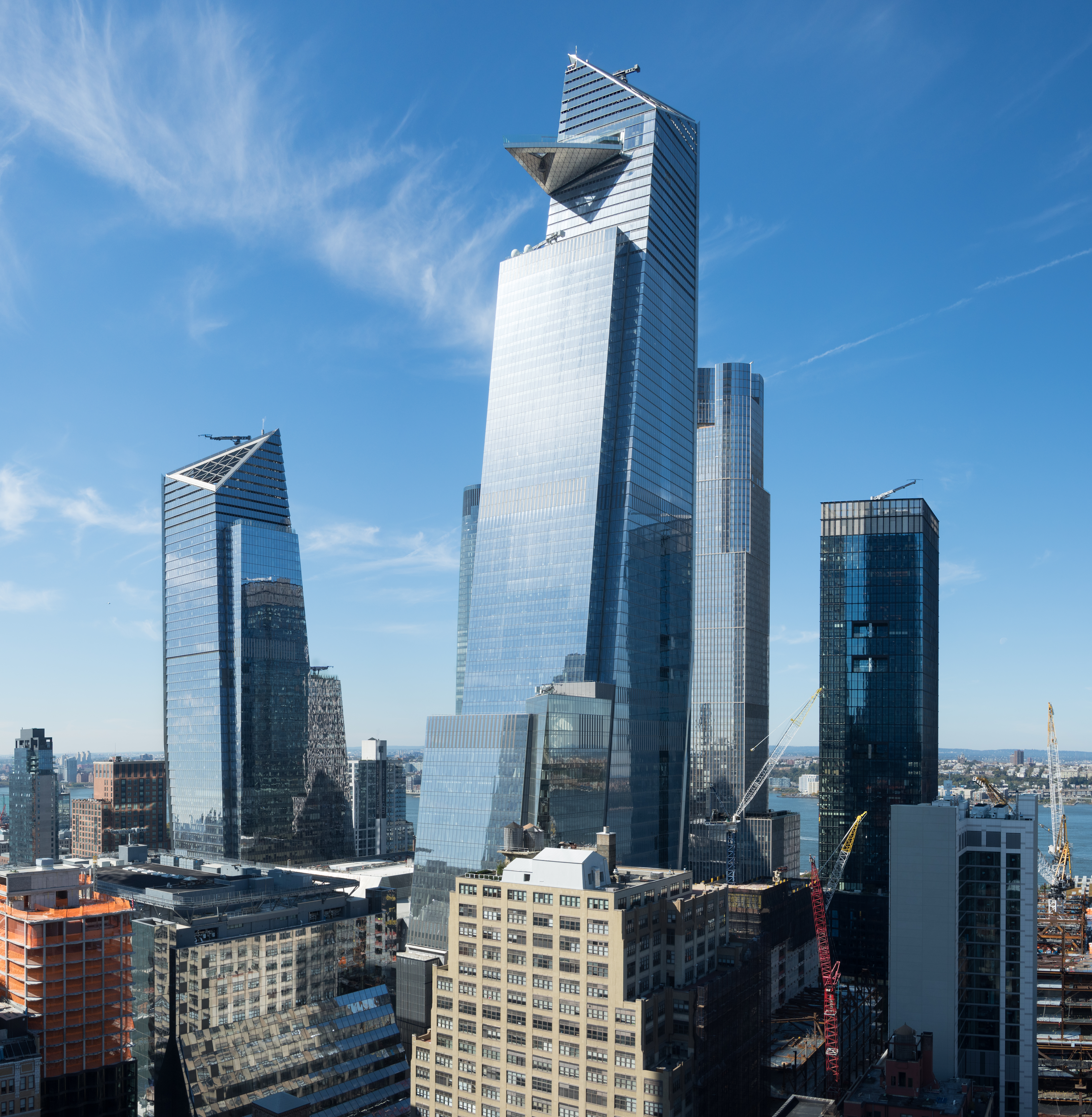
| | | | That leaves us with the six remaining numbered buildings on our map. These are all skyscrapers, and are the main contributors to what I consider to be an overbuilt area. One cannot rely on number of floors, since X number of floors in one building might be higher or lower than in another. For that reason, I'm relying on the CTBUH, which is the Council on Tall Buildings and Urban Habitat. It's the international nonprofit that is widely considered to be an authority on the official height of tall buildings around the world. From lower to higher, this is their summary of the six skyscrapers in Hudson Yards (follow on map). Note that the height category called supertall building is defined as a one between 300 and 599 m (984 and 1,965 ft) in height.
6) 55 Hudson Yards; 237 m (779 ft); 51 floors; offices & retail
5) 10 Hudson Yards; 268 m (878 ft); 52 floors; offices & retail; its southern façade on 30th Street cantilevers over the High Line Spur, and it also has an indoor restaurant underneath the spur (!)—the spur and restaurant will be a focal point of our visit
4) 15 Hudson Yards; 279 m (914 ft); 70 floors; residential; integrated with The Shed next door; additional funding came from the New York State Housing Finance Agency due to the building's affordable housing component—see below for the controversy in regard to this matter
3) 50 Hudson Yards; 299 m (981 ft); 58 floors; offices; borderline supertall
2) 35 Hudson Yards; 305 m (1000 ft); 72 floors; residential & (luxury) Equinox Hotel; supertall
1) 30 Hudson Yards; 387 m (1270 ft); 73 floors (103???); offices; supertall
The CTBUH says 30 Hudson Yards has 73 floors, and I take that to mean usable, occupied floors. The only explanation I can see for Related to claim 103 stories on this supertall is using that as an estimate of what the top level would be if there were genuine, usable floors up to that level.
The Empire State Building (102 floors without its antenna) is 381 m (1250 ft) tall, meaning 30 Hudson Yards, the tallest building in Hudson Yards, surpasses it (!), tho just barely. I don't think that's by accident. But the Empire State Building stands free, whereas all the Hudson Yards buildings, including the supertalls, are all clustered together.
30 Hudson Yards has a triangular observation deck, known as The Edge, jutting out from the 100th floor, with a bar and event space on the 101st floor. This observation deck, at 340 m (1,100 ft), is the second-highest outdoor observation deck with transparent flooring in the world.
| | | | | | The highest is Skywalk in Madeira, on the coast just west of Funchal. I was last in Madeira in May 2012, but Skywalk opened that October. It's apparently similar to one in the Grand Canyon. Still, I don't think I'd have gone to Skywalk, as I had ample high views in Madeira. I read that admission to Skywalk is free (!) as compared to the pricey fees for The Edge.
Anyway, I experienced walking on a high level glass floor in 2007, on my visit to the Copper Canyon in Mexico. It was the Mirador [Viewpoint] del (Cerro del) Gallego:
https://ecoturismobarrancadelcobre.com/wp-content/uploads/2021/04/mirador-cerro-del-gallego.jpg
https://dynamic-media-cdn.tripadvisor.com/media/photo-o/1b/e1/9a/99/photo3jpg.jpg?w=700
https://i.ytimg.com/vi/KSkriis9KWw/maxresdefault.jpg
The first link shows the entry to the viewpoint suspended over the Urique Canyon section of the Copper Canyon. The second shows walking on the glass panels on the floor to see a thrilling canyon view. The third gives the distant view (it may not look it, but the view from the platform does go relatively straight down.) Urique Canyon has a depth of 1,870 m (6,136 ft), so let's say the view looked down something approaching 1,800 m (6,000 ft). Compare that to the height of 30 Hudson Yards for a thrilling view.
|
| | | | This view shows several things. First, we see The Edge observation deck protruding from 30 Hudson Yards (Photo by Rhododendrites). Second, we see that building, just slightly taller than the Empire State Building. Third, we can see how out-of-step this cluster is with buildings in its surrounding neighborhoods and overwhelms them.
Complementing The Edge on the 100th floor is a bar and event space on the 101st floor. This observation deck, at 340 m (1,100 ft) is the second highest outdoor observation deck (in a building) in the Western Hemisphere, after Toronto's CN Tower Outdoor SkyTerrace (342m [1,122 feet]). (Chicago's Willis Tower [ex-Sears Tower] has an observation deck on its 103rd floor, at 413 m [1,354 ft], but it's enclosed.)
The cantilevered outdoor terrace juts 24 m (80 ft) outward south of the building, and provides panoramic views, here of Lower Manhattan (Photo by Hypnotoad78). Visitors can lean into the 2.7 m (9 ft)-high clear glass barricade slanted 6.6 degrees outward to safely check out the street and rooftops below. (The barricade does seem high enough to discourage jumpers.) The Edge also features a glass triangle in the floor which looks down to the street 345 m (1,131 ft) below.
As for me, I've had it with tall buildings. I've been to the former World Trade Center, the Empire State Building, and others. In Taiwan I went up Taipei 101 with 101 floors reaching 508 m (1,667 ft), and in Dubai UAE, I went up the Burj Khalifa, with 154 floors reaching 829.8 m (2,722 ft—just over a half-mile), presently the world's tallest structure. But since Nine Eleven, I've lost interest in high buildings. Even tho the newer One World Trade Center is walkable from me, I refuse to go up it, and I also reject The Edge.
https://cdn.vox-cdn.com/uploads/chorus_asset/file/15962051/8_181229_10_21_06_5DSR1777.jpg
This updated view sums it all up. This cluster of Hudson Yards buildings seems like too many candles crowded onto a birthday cake and out of sync with many of the buildings around it, which are still tall, but lower. Also on 34th Street but over on 5th Avenue, the Empire State Building seems distinguished in its isolation in its neighborhood.
https://cdnassets.hw.net/cb/47/ed4eee4945dc8489d647de5ff050/pg-hudson-yards-01.jpg
This view is apparently an artist's rendering, since it shows Hudson Yards built all the way to the river. It's just too, too much—overbuilt and overwhelming.
| | | | Schadenfreude You may know the German word Schadenfreude, which IS used in English. But to be sure, let me explain. Freude is "joy, pleasure" (so now you now know what Sigmund Freud's name really means). Schaden is "damage, harm". Thus, Schadenfreude is the pleasure you get from someone else's bad luck. But it's not really mean—it includes the proviso that the guy did deserve that bad luck. On a simple level, Schadenfreude is your happiness at the end of the movie when the bad guy gets caught—his bad luck is your pleasure. And it works similarly in real life.
THE VESSEL: I have not been pleased with Related Properties, and especially its head, Stephen M Ross, as to how Related and Ross handled the whole issue of the Vessel (still not discussed), making the Vessel now more infamous than famous. The Vessel was a very interesting idea, but now has to be considered a failure because of their machinations. It's inexcusable.
Probably Hudson Yards will gradually prosper. I've heard the residential properties are now among the most expensive in Manhattan, so maybe it's on its way. But things are not ideal at Hudson Yards, so there's a bit of room for Schadenfreude.
THE MALL: Related and Ross wanted the Mall to be a shopping mecca. Well, the first thing that happened is that Neiman Marcus went bankrupt, permanently closing its brand new Hudson Yards store along with three others. Then, during the pandemic many other stores and restaurants in the Mall closed, including Keller's TAK Room, Sephora, and Banana Republic. The Mall was such a failure that, of the ¾ of it built as retail, about 60% was converted to office space (!) in 2023. Related has said that foot traffic at the Mall in 2023 had nearly returned to 2019 levels. But Hudson Yards being so far off the standard shopping beat, I don't think that's much consolation. Pardon me if my Schadenfreude is showing.
"POOR DOOR" AT 15 HUDSON YARDS: Sometimes a major entity takes public funds to help finance a building, for which they have to provide "affordable housing"—often rental--for low-income residents, usually chosen by lottery. But the entity usually develops a strong incentive to keep these residents separate from those buying their apartments in the same building at the market rate. This is usually done by keeping the "affordable" apartments on different, usually lower, floors, and sometimes by having a separate door for them, dubbed a "poor door". Despite the fact that poor doors are illegal in NYC, Related tried to do what it could to segregate building tenants from each other.
In 2021, three Black prospective low-income tenants of the building filed a lawsuit against Related. The suit alleges the company created a different address for 15 Hudson Yards' 107 "affordable" units and that the tenants of those units would not have access to the same amenities as those in the market-rate units have. The suit alleges that, while the building does not have an actual "poor door", it does still segregate its tenants through a "poor address" with a different lobby and "poor floors". 15 Hudson Yards has a north entrance up on the Public Square which uses that address, but also a south entrance down below, under the High Line, with an address of 553 West 30th Street.
However, a New York federal judge has dismissed the lawsuit, since the plaintiffs failed to show that the building's design resulted in the segregation of Black and Hispanic residents, since the lawsuit did not demonstrate that most of the "affordable" housing residents are Black or Hispanic. The prospective tenants who'd won the housing lottery, ultimately decided against moving into the building. Their attorney is appealing the verdict.
https://nypost.com/wp-content/uploads/sites/2/2021/07/hudson-yards-entrances.jpg?quality=75&strip=all&w=744
In any case, there are two ways to enter the luxury high-rise at 15 Hudson Yards. The one up on the Public Square faces the Vessel, and doormen dressed in black suits welcome residents to a lobby where modern artwork hangs on high granite ceilings.
The other entrance is on the back end of the building at 553 West 30th Street. This entrance is a level beneath the front plaza. Residents open the door themselves. "Affordable" unit tenants cannot access the market-rate unit floors and the building’s amenities, since they receive a different key card, which only grants them access to an elevator that travels to the lower floors where "affordable" units are located.
In an online article I read, when a reporter was interviewing residents on the sidewalk outside the West 30th Street entrance, a woman who identified herself as a management team member threatened legal action if the reporter continued the interviews. This would imply that Related is embarrassed (Schadenfreude!) but also shows that Related has no standing in objecting to such an interview, since it did not take place in the building, which is private, but on a public sidewalk on 30th Street.
https://www.compass.com/m3/5f3620f104e481ded603e1635519544ff72ef0a1/640x480.jpg
This is the actual entrance down on 30th Street, below the High Line, with The Shed visible above. The earlier picture showed instead the darker entrance on the right, which is actually to a bar located under The Shed.
The moral is: don't accept public monies for financing if you're not going to properly accept the low-income people the financing paid for.
| | | | The Vessel We finally get to the centerpiece of Hudson Yards, and, truthfully, of this posting as well, the Vessel. Before we even look at it, let me say that it's grown on me. At first I thought it too ridiculous to be taken seriously, but now I respect it. I won't say I love it, but perhaps I do like it. Is it art? Architecture? Does it have a meaning? Practical use? Is it a danger to public safety?
I know that the antipathy I have for Hudson Yards centers around several things we've already discussed, but it's based primarily with the developer Related Properties and its billionaire founder and chairman Stephen Ross and how Ross dealt with not only the public but even his associates when planning and building the Vessel.
Tho it would seem that the Vessel is something for the public, like the Prometheus Fountain and Plaza function in Rockefeller Center, as it turns out the Vessel started out very much as one individual's secret pet project, meant to be his presentation of the crown jewel of Hudson Yards, and you know who that is: Stephen Ross. Ross has said that he "wanted to commission something transformational, monumental", which led to the concept for the Vessel—fair enough. It's reported then that he looked to five unnamed artists well-known for designing similar plazas, and asked them for in-depth proposals. Then he personally rejected all of the plans. At this point, a colleague introduced him to British architect Thomas Heatherwick of London. Heatherwick designed the Vessel, and then Ross personally commissioned and approved his proposal, but under great secrecy. Ross reportedly kept the model of the Vessel under lock and key in the company’s offices before the public got to see it. Only prospective commercial tenants of Hudson Yards were allowed a get a glimpse of the model. If the Vessel had been planned for anywhere else in NYC, the proposal would likely have gone through a thoro community review, but that did not happen. Given the safety issues with the structure, one wonders how a building permit was even issued, but that can remain as a matter of speculation. We'll see later that Heatherwick Studios was concerned about safety, but Ross rejected its suggestions. This leaves Ross, not Heatherwick, responsible for the safety issues that plagued the Vessel.
HEATHERWICK: Heatherwick's quality work first appeared in NYC earlier than with the Vessel. Plans arose in November 2014 for a new park designed by Heatherwick Studio, but delays caused it to open late, in 2021. It's called Little Island at Pier 55, at West and 13th Streets. Little Island--here looking south to Lower Manhattan--is an artificial island supported by 132 pot-shaped structures called "tulips" (click) suspended above the water, which in turn stand on 280 concrete pilings extending into the riverbed (Photo by Praneeth Thalla). I enjoyed visiting Little Island when it opened and have online notes to write about it more completely in the future.
Of the other projects designed by Heatherwick Studio, nothing to me is as impressive as his Rolling Bridge in London, which was built earlier than either of his New York projects. The Rolling Bridge is, like the Vessel, sui generis. It's a kinetic (moving) sculpture and a unique type of curling-up moveable canal bridge, completed in 2004 in Paddington Basin, London (Photo by Loz Pycock). It opens by curling into a circle (!) rather than rising in one or more rigid sections. It consists of eight triangular sections hinged at the walkway level that can be collapsed towards the deck by hydraulic cylinders mounted vertically between the sections. When extended, it resembles a conventional steel and timber footbridge, and is 12 meters/yards long. To retract the bridge, the hydraulic pistons are activated and the bridge curls up until its two ends join, to form an octagonal shape measuring one half of the waterway's width at that point.
The Rolling Bridge could theoretically allow the passage of boats, but the tiny basin it crosses is not a genuine waterway. The sculpture also has a long cycle time, taking 2–3 minutes to finish opening or closing, and anyway, the pedestrian detour around the open bridge to avoid it is very short, so the crossing is not really necessary at all. That makes the bridge primarily public art rather than a practical structure for navigation. "Rolling" as used in its name is a historical term—the modern term would be "retractable bridge". The bridge "performs" only once a day, three times a week, as shown in this YouTube video (2:14).
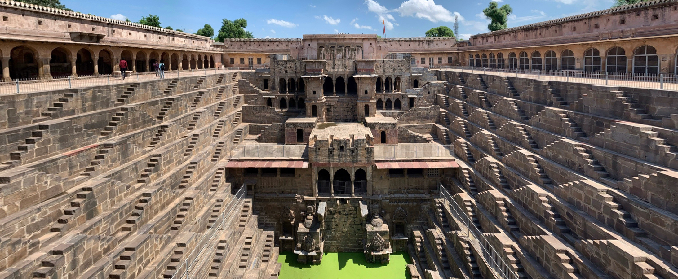
Back to the Vessel. It seems that Heatherwick modeled the Vessel after Indian stepwells. I didn't know what those were, but now find what he did very revealing. A stepwell (think: steps down into a well) is a well or cistern with long flights of steps that descend down to the water level. It functions as a storage and irrigation tank to cope with seasonal fluctuations in water availability and make it easier for people to reach the groundwater and to maintain and manage the well.
This is a panorama of Chand Baori (click), a stepwell dating from the 8C-9C that extends approximately 30 m (100 ft) into the ground, making it one of the deepest and largest stepwells in India (Photo by Chainwit). It has 3500 steps descending 13 stories deep up to a massive water tank at the bottom. It narrows at the bottom, so it was constructed like an upside-down pyramid. Just as a stepwell has staircases going down below street level, Heatherwick seems to have flipped that concept, designing the Vessel with staircases that go from street level up into the sky.
The bottom line is that the Vessel is an interesting concept and a positive addition to the NYC scene by an esteemed London architect, but stems from a secretive background strongly controlled by one individual.
Our map shows where it's located in the Public Square. This is how the Vessel appears (click) looking north from The Shed on the left (Photo by Epicgenius).
The installation is a 16-story freestanding hollow structure of connected staircases and walkways for visitors to climb. The walkways between the tops or bottoms of staircases can also be considered landings, for viewing. This photo was taken when it opened in March 2019, and shows very few people. It was just as empty like this when Simi and I visited on an exceedingly hot day in 2021, tho other photos will show it much busier.
There are 154 staircases with nearly 2,500 individual steps, interconnected by 80 landings/walkways. The total length of the stairs exceeds 1 mile (1.6 km). The stairs are arranged like a jungle gym (monkey bars) and can hold 1,000 people at a time. The Vessel is 15 m (50 ft) wide at its pentagonal base, expanding to 46 m (150 ft) across the top, making the structure as tall as the top is wide.
The Vessel was built in sections fabricated in Italy, then assembled onsite. While it looks like it's made of copper, it's made of highly polished sheets of copper-colored steel covering the framework, reflecting people in the square below while remaining high enough to discourage vandalism. (The surface of the Statue of Liberty is made of actual copper plates, which have oxidized to its signature green.)
Since the Vessel was designed for people to climb over, engineers took pains to stabilize the latticework of stairs, making the structure immune to both the wind and overactive visitors. Unbalanced-load scenarios were considered, such as when a concert (in The Shed?) or other event would cause all of the occupants to stand on one side or the other, or move up and down in unison.
The structure also has ramps and an elevator to comply with the Americans with Disabilities Act of 1990 (ADA),though only three of Vessel's landings were ADA-accessible as of 2019.
CRITIQUES: The reviews of the Vessel varied from being described as "mixed" and "negative". Some critics praised its prominent placement within Hudson Yards, while others derided the structure as extravagant. The New York Times architecture critic called it "gaudy". One article described it as "NYC's gigantic public art failure".
But one thing was particularly criticized: the restrictive photo policies in its first year. Incredibly, Related claimed copyright ownership of all pictures and videos taken of and from the Vessel, and reserved the right to use any photos or videos taken for commercial purposes without paying royalty fees. This privileged claim for the use of photos and videos by Related, a private company, was criticized because Related had benefited from $4.5 billion in tax revenue. After this criticism emerged, Related modified the policy so that visitors would have ownership of their own photos and videos of Vessel.
THE FUNCTION: Towers and tower-like structures usually have a function. Castle towers are for defense, allowing an arriving enemy to be seen. Fire towers allow wardens to spot distant flames, in the forest, and once, in cities. Lighthouses are meant to protect ships. The Leaning Tower of Pisa is a campanile (bell tower) for the adjacent cathedral. Clock towers make the clock visible.
Asking what the function of the Vessel is is like asking what the function of the Eiffel Tower is (to which it's been compared). Actually, the same answer works for both: observation. That's why people take the elevators to the three visitor levels of the Eiffel Tower, and that's why they climb the Vessel, which offers observation from eight levels.
Official comments about the Vessel's function state that it's to be an interactive public space, meant to engage people to socialize. Maybe so, but while there, they're observing and admiring the various views. Some may say it's to offer exercise possibilities, like a connected group of StairMasters. Tho this might seem logical, I doubt that's why it was built.
THE NAME: Tho the structure had no official name originally, the Hudson Yards website first called it the "Hudson Yards Staircase". Not bad—maybe they should have stuck with that. But then it got the present name, which did stick. Actually, the name is often cited without the article, which perhaps was meant to be the official name. But to say "He climbed Vessel" sounds pretentious. I'll stick with the commonly used "He climbed the Vessel".
But I still think the name is imperfect. A vessel is a hollow utensil, such as a cup, vase, or pitcher, used as a container, especially for liquids, and I don't see that. If it's to be a container, I feel it should be considered to be more of a basket, and that's the way I continue to think of it.
However, there have been other thoughts. A writer in the NY Times said the Vessel was a "stairway to nowhere". It's been compared to a beehive, honeycomb, pineapple, spiral staircase. It's also been called the Great Shawarma.
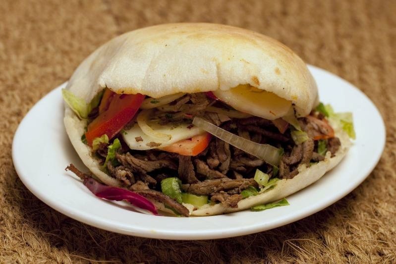
Visually, calling it the Great Shawarma works quite well. When many of us talk about having a gyro sandwich on a pita (Photo by Vera Yu and David Li) based on the grilled meat being sliced off a revolving spit (Photo by Vaikoovery), the word shawarma is also frequently seen on food carts. A shawarma (shə.WAR.mə; middle syllable rhymes with "tar") consists of meat (traditionally lamb) cut into thin slices, stacked in an inverted cone, and roasted on a slow-turning vertical spit. The surface of the rotisserie meat is routinely shaved off once it cooks and is ready to be served. It's of Ottoman origin, and started out with the Turkish name döner kebab. It was brought to West Berlin by Turkish immigrants, where that name is still used. In Canada it's donair, and in Greece, gyro (since it revolves), which is where Beverly and I first came across it many, many years ago, and that's the word I usually use. But the Arab name is shawarma. Anyway it suits the Vessel, since, the color is right, as is the shape.
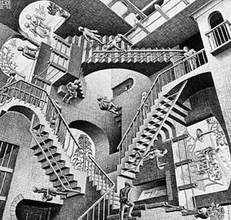
FURTHER THOUGHTS FROM FRIENDS: Dave is the only one I know who actually climbed the Vessel, and that was during its opening phase. He explained: The Vessel is more than just to look at--you can climb the scissor-like stairs [my boldface] or take the elevator to the top. Once you are inside, it almost looks like an Escher print--you can't really tell where one geometric stairway ends and the other begins. It's pretty cool and unique. It's free, but the staff dispenses timed tickets for entry to prevent it from getting overcrowded. I have never waited longer than 20 [minutes].
To make sure everyone understands the reference: MC Escher was a Dutch graphic artist particularly known for his prints of impossible objects, such as this lithograph from 1958, called Belvedere:
https://i.etsystatic.com/17244327/r/il/e24370/1694320436/il_1080xN.1694320436_neok.jpg
Click on the main row of columns to see how impossible they are. Then move to the boy on the bench to see that he's holding an impossible box. But it's from his 1953 lithograph called Relativity where you can imagine connections to the Vessel.
Simi has said: The Vessel is a wonderful amalgam of the hideous and exquisite and [is] totally pointless. . . . Aside from its novelty elements it is a meaningless structure-sculpture, however it may be defined. I recall when we were there that she said she liked the "pointlessness" of it all. I commented at the time that leaving it as is, attractive yet empty, would be a statement to failure. Failure of Related Properties and Ross of course, but also a blatant failure within NYC.
THE VESSEL AS ART/ARCHITECTURE: There are numerous references to the Vessel as a sculpture, and I strongly disagree—the Vessel a building, which makes it architecture. A sculpture can be large, even larger than life. But any structure people can walk into is a building. I refer back to our recent discussion (2020/10) of the Oculus looking like a bird taking off, yet it's a building. I think the best example of that was my pointing out that the "Statue" of Liberty is in reality a building whose lower level is styled as a pedestal and whose upper level has copper plates affixed to it to make it resemble a statue. In this building, people take elevators in the lower part and climb stairs (!) in the upper part. I also talked about Lucy the Elephant being a building. And by this definition about people being able to enter and climb it, the Vessel is a building, styled as a sculpture.
But there's no doubt that it's styled as an abstract sculpture, and in that regard, I'd like to make a comparison. The Romanian-French sculptor Constantin Brâncuși (bring.KUSH) worked in abstract shapes. Possibly his most famous work is Bird in Space, which he first created in 1923, but which he crafted 14 times in several mediums, including marble and bronze. The first and best known is in marble in the Met in NY, while two bronze versions are in MoMA. This is a bronze version of Bird in Space in the Philadelphia Museum of Art. It's described as being characterized by a smooth, elongated form and reflective golden surface. Brâncuși didn't concentrate on the physical characteristics of the bird (wings or feathers), but instead on its movement.
I invite you to compare Bird in Flight as abstract art with the Vessel as abstract architecture. Look again at the above external view we saw of the Vessel (Photo by Epicgenius).
| | | | | | The pair of vertical black lines are the elevator tracks (more later). But click to look at the low guard rails on the eight levels, each of which, if not equivalent to a rooftop, could be an open balcony. Do you see a recipe for tragedy?
On a walkway such a low barrier might be off-putting, and coming down a staircase even more so. It would seem if a person tripped, he could go over the edge. What if two teenagers were roughhousing? The both could go over. But while four deaths have occurred at the Vessel, none were accidents.
All were jumper suicides.
|
| | | | THE VESSEL AS A (SAFE) VISITOR ATTRACTION: Thomas Heatherwick said that he intended visitors to climb and explore the structure as if it were a jungle gym (also known as monkey bars). But where does a place to explore become a potential public health hazard? Even before the Vessel was finished, critics voiced concerns about safety. Members of the public also repeatedly called for additional safety measures to be installed over the years. But Related Properties (Steven Ross) refused to raise the height of barriers along the sculpture’s staircases and walkways, something community members and a local community board had been pushing for. After the fourth (!) jumper tragedy, an employee of Heatherwick Studio said that it had designed higher safety barriers and expressed frustration with Related's resistance to installing them: "We designed safety barriers for the Vessel a while back. It’s now time to install these."
It becomes obvious that we have to know more about the phenomenon of suicide in order to fully understand what the Vessel has unfortunately come to symbolize—and by extension, all of Hudson Yards as well. We'll talk about suicide, and particularly jumper suicides, in the next posting. This discussion so far has been The Vessel I, that will be under the title The Vessel II.
| | | |
| |
|
|
|

