| | It’s the next day on the Southwest Chief, rolling between Kansas City and Chicago. | |
| | Returning from Fort Ross our Michelin suggested stopping in the town of
Bodega nearby. Its claim to fame is the ornate Victorian Potter School of
1873. Alfred Hitchcock used it as the school in The Birds (1962).
| |
| | Also on the way back we couldn't help stopping once again at Muir National Monument to see the redwoods again. This trip we were there just before evening, with few people, so a few lines from Woodie Guthrie’s “This Land” were appropriate which the two of us really did sing, with me pushing Bev along in the wheelchair under the redwoods. Listen to Guthrie himself sing it in a vintage recording from 1945. In this early version on YouTube, he still has a couple of extra syllables here and there that later disappeared: Woodie Guthrie: This Land | |
| | | | This land is your land, this land is my land,
From California to the New York island,
From the redwood forests to the Gulf Stream waters
This land was made for you and me.
|
| |
| | San Francisco The views. The attitude. The lifestyle. The best. I don't see
how you can get a bad view in San Francisco unless you flash a light down a
dark alley and look at garbage pails.
| |
| | The Views Even if you've been there, you might want to try this. With your
right hand put thumb and forefinger together to make the A-OK sign. Then put
a quarter-inch space between those fingers. You've just created the body of
water known as the Golden Gate (Map by Decumanus). It forms the entrance from the Pacific Ocean
to the left of your hand to San Francisco Bay in the circle of your fingers.
Your thumbnail is SF. Although it expanded to fill its "thumbnail", it never
expanded beyond into the Bay Area, so its population and area are deceivingly
low in regard to its regional importance.
| |
| | From your thumbnail picture a bridge across the bay to your knuckle, which is
Oakland. This is the Bay Bridge. From your thumbnail picture a bridge across
to your forefinger, which is Marin County. Since it crosses that "1/4 inch"
Golden Gate, it is logically the Golden Gate Bridge. I am convinced that many
people are not aware that the Golden Gate Bridge is named after anything, but think that it itself is some sort of “gateway”. It’s the waterway below that’s the gateway to the bay.
| |
| | Consider further that the lay of all this land is hilly, that there are a
number of Bay islands such as Alcatraz, and that there are a lot of cliffs
along the Golden Gate and Pacific side.
| |
| | How can you stand anywhere and look down a street (most of them straight as an arrow) and not get a drop-dead gorgeous view of hills, bay, bridges, islands, and so on? | |
| | Steep Streets Steep streets are uniquely San Francisco. But why does it have some notoriously steep streets? It didn't have to. Other cities with hills have streets that are not overly steep. So what's the reason for the streets being steep? In my opinion
it was San Francisco attitude.
| |
| | Most American cities have street layouts on the grid plan, where all streets
are parallel to each other and perpendicular to cross streets. But when
coming to a hill, usually something special happens, such as having a street bend
around a hill or spiral up the hill.
| |
| | When San Francisco was laid out on a grid pattern, the only concession to nature's lay of the land was at Telegraph Hill. The regular streets stop and a special road circles up to the Coit Tower at the top. | |
| | But at the western part of downtown (elsewhere, as well, but let's
concentrate on downtown for simplicity) rise two more formidable hills, Nob
Hill, and to its immediate north, Russian Hill. Here, the town planners made
no concession at all, which is what I mean by attitude.
| |
| | Let's look at a graphic illustration. Suppose there were a striped tablecloth on
a table. The parallel and perpendicular lines could be the street plan of Des
Moines, or any other flat city.
| |
| | Now let's say there were two glasses on the table that you wanted to protect from dust, so you put this striped tablecloth over them and the entire table. Seen from above, the lines on the tablecloth remain parallel and perpendicular, even as they rise over the glasses, and you cant see the steepness that's really there. Much of SF may have slightly sloped streets, but what's famous are the steeper ones around Nob and Russian
Hills, just like those glasses under the tablecloth. One east-west street usually crosses over the
top of each hill, but most of them cross at varying heights along the sides.
But the north-south streets will cross both hills, including a dip into the
cleavage between them.
| |
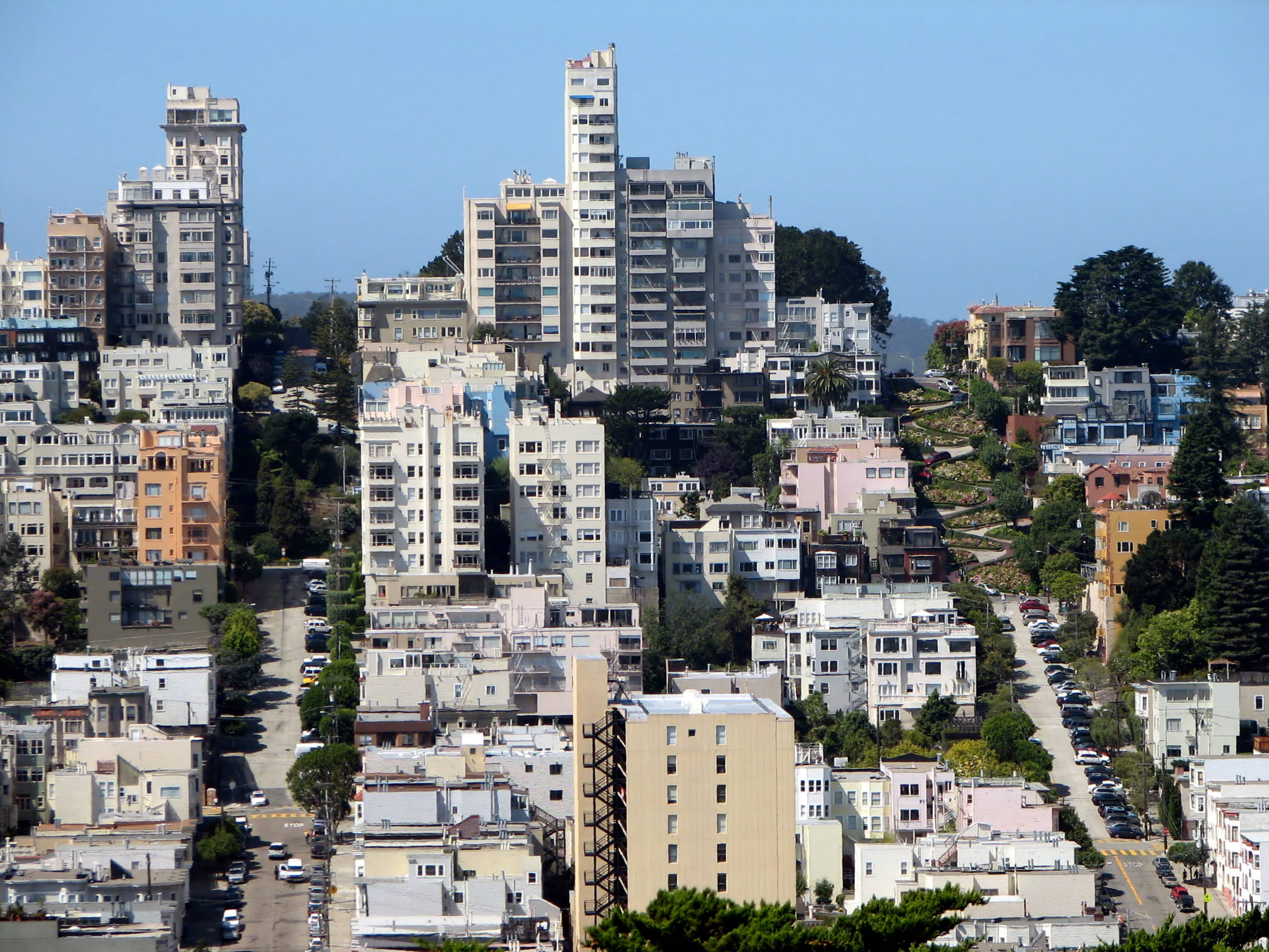
| | Now please realize that, since the grid is laid out so straightforwardly, if
you look at a map of San Francisco (Click to enlarge) (Map by Dr Bloefeld) there is no way you can tell that Nob and Russian Hills are there if you don't already know it, because no streets circle around them as they would elsewhere. Note the winding streets around other mountains in the south, away from downtown. Then compare them to Russian Hill as it rises before you, looking west (Photo by Bernard Gagnon). Off the picture to the left, Filbert Street successfully manages to cross over the top, but the hill gets too steep for Greenwich Street, here on the left, which ends abruptly, skips the steepest part (left as green parkland), and then reappears higher up. To the right is the most famous street, Lombard Street, where the steepness has been overcome by a series of (downhill) hairpin bends, with gardens in between. Those were not put there as a tourist attraction, although they have become that, they were put there to make Lombard Street a through street.
| |
| | On our last trip, we should have known better, but we'd just arrived and
didn't think. We rented the car, Bev was driving, and I found that Taylor
Street at the next corner would get us to our hotel. At that time it was
unfortunately a stick shift.
| |
| | Turn the corner and whoosh you're on a one-way going up Nob Hill. You have
the sensation of a plane making a steep ascent and falling back in your seat.
I was hoping she'd make the light at the top, but no, so we stopped just
before it became flat at the top. In any case, all hill streets without
traffic lights at cross streets have stop signs, since they don't want some
panicked driver shooting up a hill and into an intersection.
| |
| | But up at that top of the hill waiting for the light to change, you want to
reach out and hold onto blades of grass, or get your fingernails into the
pavement, since you know you're sitting backwards at the top of a
rollercoaster.
| |
| | Then of course, we went down the cleavage, up Russian, and down Russian. And
do keep in mind that all these streets have cars parked (!!!) on one or
both sides, usually angled to the curb, and with wheels turned in. But even so.
| |
| | This trip we had an automatic car, and I wanted to try out Taylor Street
again, this time voluntarily. Actually it wasn't so bad. Nob Hill is flat at
the top for a few blocks, probably manmade, for all the posh hotels, clubs,
and cathedral. But I could see that it really was Russian Hill that was
worse. Taylor doesn't cross the summit; the next one over does. But Vallejo
crosses east-west. As it comes from the east, the hill just is too much for
it, even for San Francisco, and Vallejo becomes a flight of stairs (with park) for
pedestrians. Then it crosses Taylor where we were, and becomes stairs and
park again up to the summit, which, as we later saw, is gorgeous.But as
Taylor crossed over Vallejo, there wasn't the flatness of the top of Nob
Hill. It was like driving over a capital A: up one side, across the few feet
of the Vallejo intersection, then down again. But again, this time it was
voluntarily.
| |
| | Needless to say, buses and trucks aren't allowed on the steep hills. But
everyone's seen along the road when driving a warning for trucks to use low
gear because of a hill coming up, usually with a percentage like 9% or 16%.
Visually pace off ten feet from a wall, then find a point one foot up the
wall. Connect those points, and you have a 10% slope. The same ten feet
connecting with two feet up the wall is 20%, and three feet, 30%. Now
remember, a 30% slope is a 30-degree angle.
| |
| | Michelin lists the eight steepest blocks in SF. The majority are in the
Russian Hill area with grades of 24-29%. The winner is there, too, Filbert
between Hyde and Leavenworth, with 31.5%. I didn't try any of them.
| |
| | If you want to try driving one of those blocks to see how you measure up to
San Francisco's attitude of superiority over nature, prepare yourself for a good workout.
| |
| | Cable Cars It's a shame about the cable cars. They're so wonderful, yet
they're treated like rides at Disneyland. When tourists wonder why some lines
end at points they're not particularly interested in, they fail to see that
the car lines were laid out to serve local people, like any commuter bus
line. But I suppose it was the tourists' interest that saved them. Here, a Powell-Hyde car (Photo by Aude) has just climbed south up steep Hyde Street (look at the drop behind the car) from Fisherman's Wharf and has stopped at the intersection of Lombard Street, whose famous switchbacks (above) are immediately off to the right of this picture.
| |
| | The wonder of the cars is that they're really so low tech. After them came more elaborate technology for streetcars, but they themselves are still just a step up from the simple horsecar. As a horse pulled a wagon full of urban commuters, so later a cable did the same job. | |
| | The car is not powered. Its lights must run off a battery. It just sits on
tracks. You don't get much more low-tech than that. But then just underground
between the tracks runs the cable at 9.5 mph, for miles under the car routes,
coming out from the car barn (worth visiting to watch it happen), over a big pulley, and back. Just like a guy on roller skates who grabs a moving rope,
moves, and stops when he lets go (and brakes as well), the cable car moves. I
always feel the gripman, whose workspace takes up a considerable part of the
car, is the Master of the World, flamboyantly engaging the cable, as well as
the break. The tighter you engage the cable grip, the faster you go.
| |
| | Since cable car lines cross, cables cross. Think about it. If you know your
cable crosses on top, you're fine. If you know you're on the bottom as you
cross, at exactly the right time you have to release, then re-engage. Whew.
| |
| | Think of the friction of engaging and disengaging. The jaws of the grips have
to be replaced every few days, and the entire cable every month or two.
| |
| | San Francisco used to have a lot more lines than the present three. Some just folded
over time and many were done in by the 1906 earthquake.
| |
| | The abilty to deal with hills certainly made them ideal for San Francisco, but almost no one knows that a good number of other cities had them. I remember hearing of
cable car lines in St. Paul and Chicago, and I know New York had lines on
Lower Broadway and around Union Square. I understand there was a corner of
Union Square in New York that at the time was known as Dead Man's Curve,
since the gripman had to release the cable on 14th Street, coast around the
curve, then engage the crossing cable. And the movie theater we sometimes go
to, the Angelika Cinema on Houston Street and Broadway, shows
films below street level. The building is still known as the Cable Building
and the screens are in the area where the cable fed out into Broadway.
| |
| | Van Ness Ghosts I've always felt that visualizing "ghosts" of former
buildings gives you insight into how a town or city once was. When I walk
down Wall Street, I can "see" the ghosts of the Dutch cottages along the
south side of the street (making much more sense fitting in the winding-lane
street plan than the skyscrapers) and the ghost of the pallisade wall along
the building line on the north side, making Wall Street the first street
inside the wall on the north side of town.
| |
| | I think most people misunderstand exactly what happened in the 1906 San
Francisco earthquake. Obviously the quake itself, with aftershocks, did a
considerable amount of damage. But it wasn't over then, because then came the
fire. The quake had ruptured gas mains, and the fire spread for days and
days. This was a wealthy city, with Gold Rush money and money from the silver
of the Comstock Lode, as well as from commerce, and an awful lot of
attractive property burned away. We've seen pictures of ladies in long
dresses looking down the hills at the charred city.
| |
| | But that doesn't explain the poignancy of my Van Ness ghosts. Van Ness Avenue
is a major north-south street on the western side of downtown. That location
is crucial to the story.
| |
| | Van Ness today is a commercial street, with car dealerships and the like. But
in 1906 it was a well-to-do residential avenue, with mansions lining both the
east and west sides of the street.
| |
| | You have the idea. Van Ness was to be the firebreak for the San Francisco
Fire. But even more poignantly, only the mansions that, by fate, had been
built on the eastern, or downtown side were to be sacrificed to save those on
the western side and beyond. And it worked.
| |
| | But think of the owners. If (looking north) you were on the right side, you were grateful. If you were on the left, you saw your houses being flattened with no fire in sight. | |
| | So even though all the mansions are gone on Van Ness now, when I drive down
it I see the ghosts of the saved ones on one side and the marble and
mahogany being bulldozed on the other in advance of the fire.
| |
| |
| |
|
|

