|
Reflections 2017
Series 9
June 21
Pre-Columbian Civilizations: Mayas, Aztecs, Incas - Central Andes Geography
| | I remember it well. It was somewhere in 5-6 grade that we learned about the major civilizations of the Americas, and were told there were three, Mayas, Aztecs, and Incas. These are the major ones, yes, but there are other American civilizations in both North and South America that left ruins and monuments of where they had been, such as those that built Mesa Verde in Colorado (2007/14) and Cahokia Mounds in Illinois (2015/20). In addition, when researching La Paz, I learned of (but did not visit) a pre-Inca site in Bolivia left by the Tiwanaku civilization, and there are others. So keep in mind the other pre-Columbian civilizations in the Americas, not just the big three we always hear of—but then, these three did leave very spectacular monuments and ruins. Of all the others, I will want to include the Olmecs of Mexico for reasons to follow. | | | | I want to first summarize my visits to the Maya and Aztec areas in 1967, and how I finally completed my "Big Three" Pre-Columbian American Civilizations trifecta by visiting Inca areas in the Central Andes, just a bit in Ecuador in 2015, but primarily precisely a half-century after the two others, in 2017 in Peru and Bolivia. Frankly, I was totally unaware of this 50th Anniversary until writing up my post-trip notes. I rarely plan anniversaries that are as notable as this, they just happen—it was meant to be 2015, but wasn't really completed until 2017. | | | | July-August, 1967 After we were married in 1962 following our year studying in Mainz, Beverly and I took regular, lengthy trips for many years during the summer breaks from teaching. Eight, even up to ten weeks, were not unusual for those years. It was in the summer of 1967 that we decided on an extensive visit to Mexico between 3 July and 20 August. I suppose that comes to seven weeks, but then, on the way back, we stopped in Minneapolis to visit Beverly's family for at least another week, so that filled out the two months.
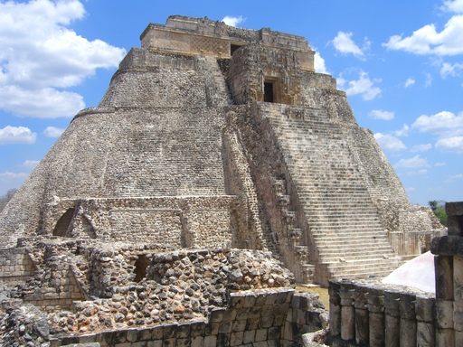
| | | | Our purpose was to take a three-week course at the Universidad Iberoamericana in Mexico City to study advanced Spanish and Mexican art history, but then also to tour the country extensively, by plane (!), bus (!) and even one overnight train in a sleeper to Guadalajara, a train that no longer runs. In retrospect, I think it odd we never rented a car that summer. We flew from New York via New Orleans (my first visit) to Mérida in the Yucatán for the Mayan culture. Follow the trip on this map of Mexico. | | | | We later flew to Oaxaca (wa.HA.ka) in the South, then visited a flurry of places, including Acapulco, Guadalajara, Pátzcuaro, Morelia, Guanajuato, Dolores Hidalgo, San Miguel de Allende; Querétaro, Puebla, then finally ended in Mexico City for the course and to visit Aztec sites. When it was over, we flew via an afternoon in San Antonio (my first visit there) to Minneapolis and family. | | | | Mayas Arriving in Mérida in early July, we hadn't realized how hot it would be adjacent to the jungles of the Yucatán. We were trying to save money, and our travel diary says we took an antiquated bus into the city. We found a budget hotel, that did have a pool, but which was without air conditioning. We had a day in town, and I do remember coming back after walking around and flopping on the bed under the ceiling fan. But then we (somehow) arranged two tours over the next two days, one to Chichén Itzá and one to Uxmal. For this we should look first at this map of the extent of Maya civilization (Map by Kmusser), shown here in red, with all other Mesoamerica cultures shown in black. While this was a visit to Mexico, do keep in mind that the extent of the Maya civilization covered several modern countries (Map by Nepenthes): all of southernmost Mexico, including the Yucatán, all of Guatemala and Belize, and parts of Honduras and El Salvador. The Maya Empire reached the peak of its power and influence around the 6C CE, but that most of their great stone cities were abandoned by 900 CE. The two abandoned stone cities we'll visit show up better in this detail (click) of the Yucatán Peninsula (Map by Peter Fitzgerald). Chichén Itzá is about 121 km (75 mi) to the southeast, while Uxmal is about 80 km (50 mi) to the southwest.
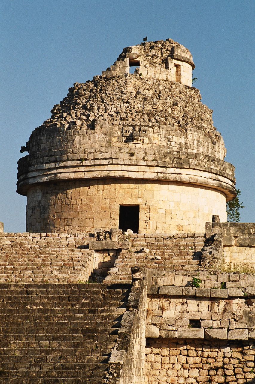
| | | | Chichén Itzá Both words are end-stressed (though often reversed in English), and so Chichén Itzá is pronounced chi.CHEN it.SA. (I remember how in elementary school we joked that it looked like you were trying to say "It's a Chicken".) It was a pre-Columbian city whose name means "at the mouth of the well of the Itza [people]" and whose Classic Period ran from 800-900 CE. It was one of the largest Maya cities and is one of the most frequented archaeological sites in Mexico, seeing 1.4 million visitors a year.
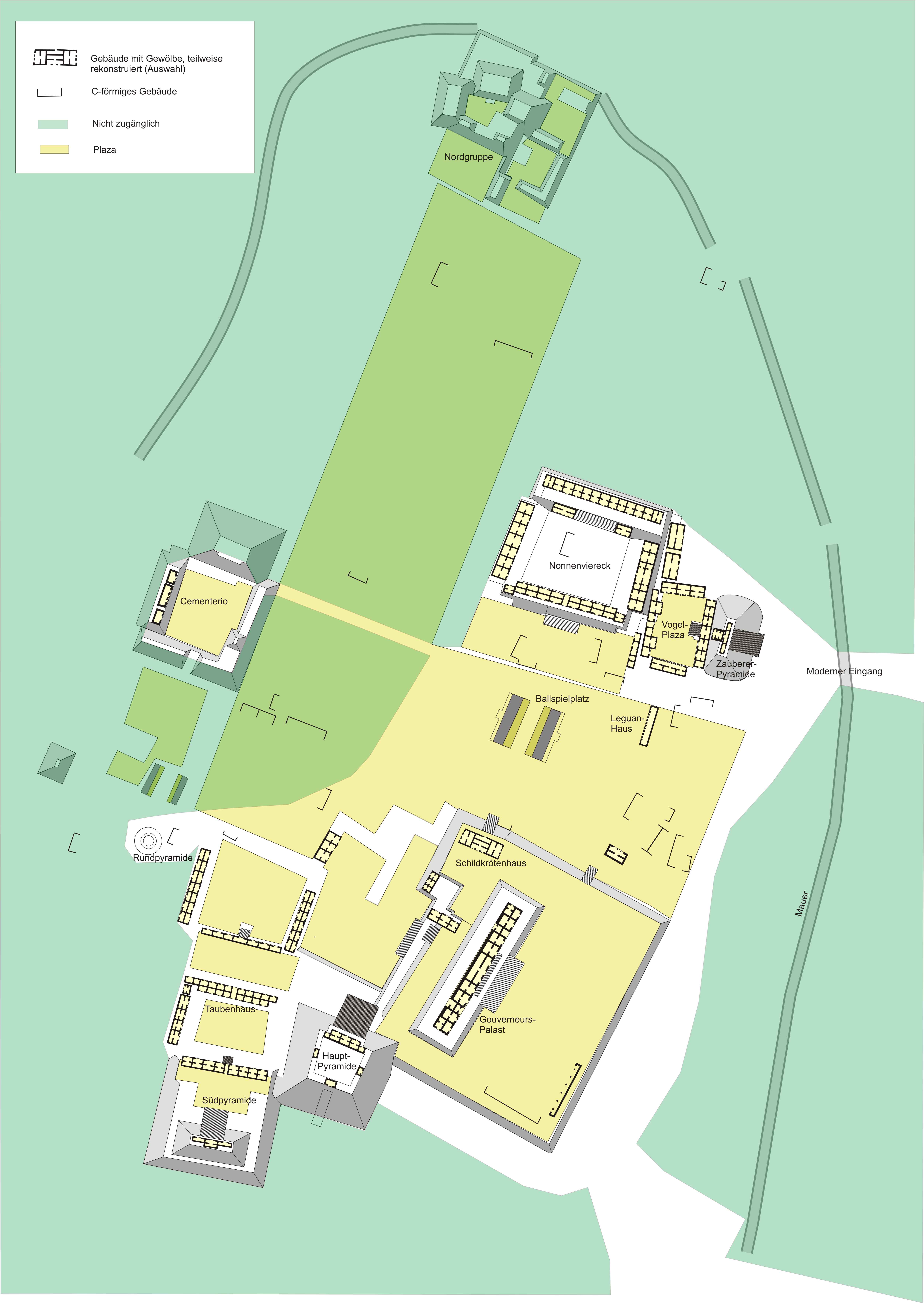
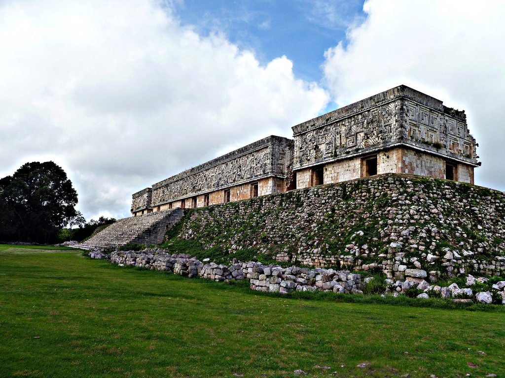
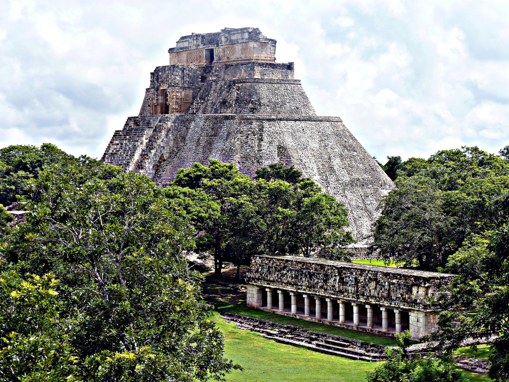
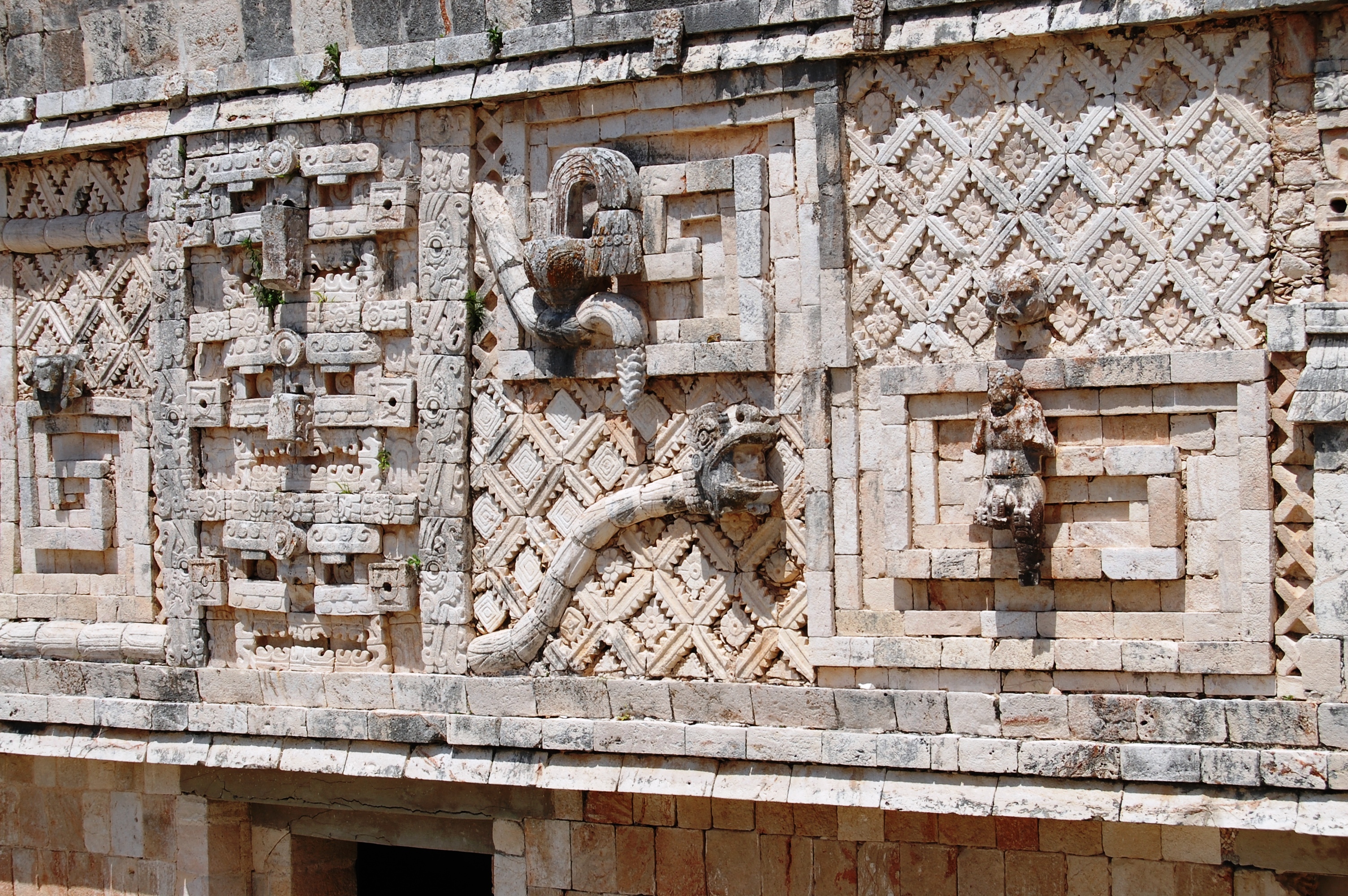
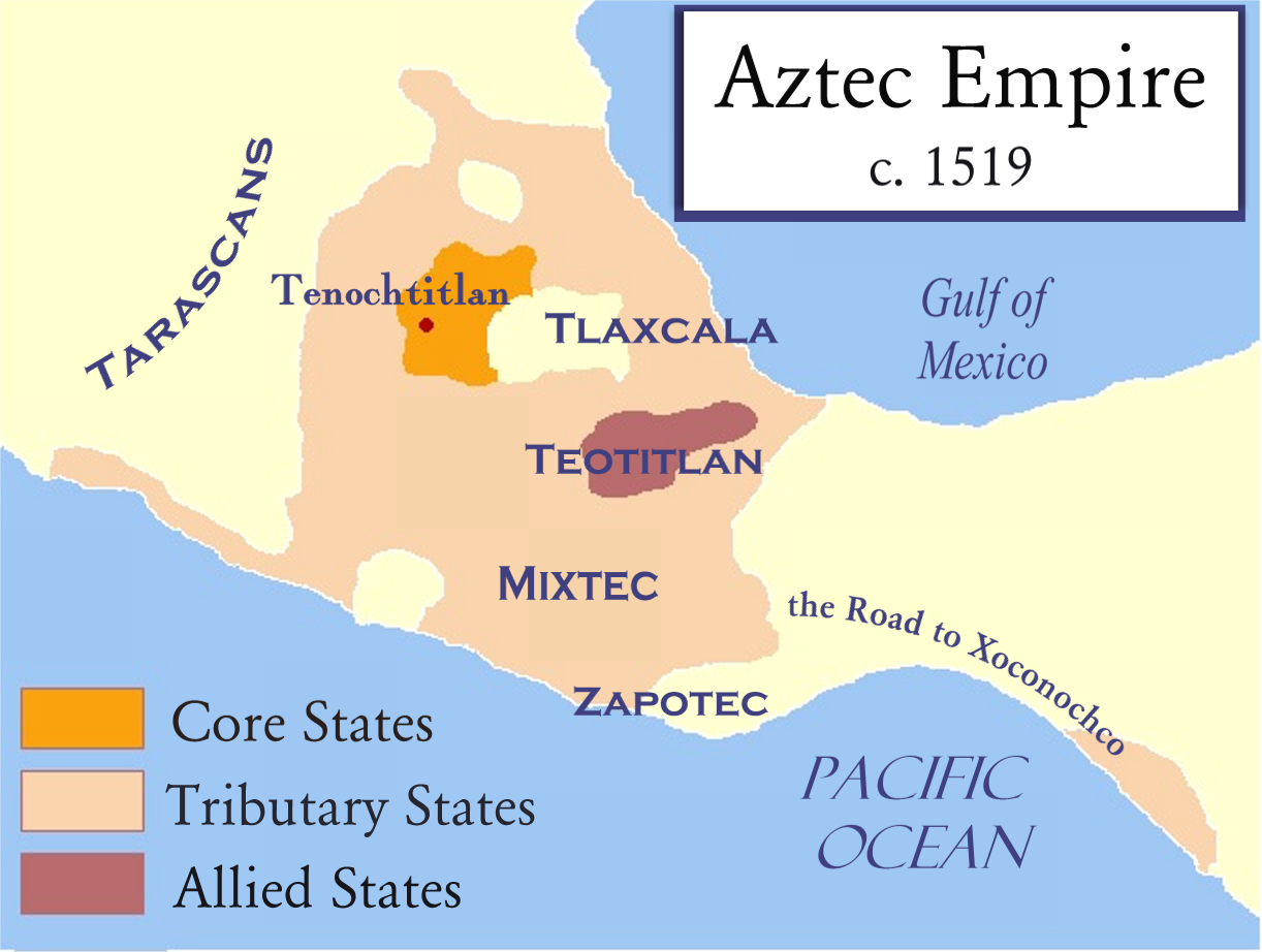
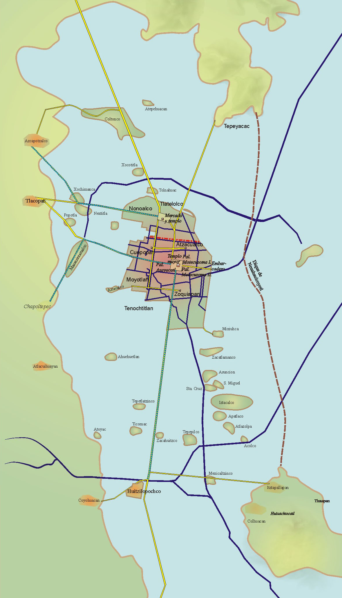
| | | | This is the site plan of Chichén Itzá (Map by HJPD), but we'll only mention some highlights we saw on the full-day trip. Probably most famous is located in the upper center, what is known as el Castillo/the Castle (Photo by Daniel Schwen), but which is more accurately the Pyramid of Kukulkán, topped by the Temple of Kukulkán, a Maya feathered serpent deity. It's a step pyramid 30 m (98 ft) high to the top of the temple, with nine square terraces. Each of the four faces of the pyramid has a protruding staircase rising at a steep 45° angle. It's possible you're allowed to climb the 91 steps, I don't recall, but that assumes you have no concern for life and limb. Best stay off. | | | | There was a sport played in the area since 1400 BCE referred to as the Mesoamerican ballgame that included ritual aspects. It's believed to have been similar to raquetball. Archaeologists have identified numerous ball courts for playing it, but the most impressive one is the Great Ball Court (Photo by Bjørn Christian Tørrissen) near the Castillo (on the map, in Spanish, Juego de Pelota). It's the largest and best preserved ball court in ancient Mesoamerica, measuring 168 x 70 m (551 x 230 ft). Click to locate in the center of the opposite walls the stone rings carved with intertwined feathered serpents. This is a detail of one of the stone rings (Photo by Kåre Thor Olsen), located 9 m (30 ft) above the floor. Are these perhaps some sort of goal posts, or even some sort of vertical "basketball hoops"? | | | | The Yucatán has natural sinkholes called cenotes, fed by underground springs, two of which are found at Chichén Itzá. They could have been used as a water supply in the otherwise arid area. The more famous one is the Cenote Sagrado (Photo by Intelec12), or Sacred Sinkhole, off the map on the top. In it there were sacrificed objects, as well as human beings. | | | | There's more, but let's move to the southern part of the site (see map) to visit another very distinctive building called el Caracol/the Snail (Photo by Daniel Schwen). The round building on a square platform is actually most likely an observatory, but gets its name because of a winding staircase inside. Here's a detail of the upper part (Photo by Bruno Girin). Those windows on the top level, now partially destroyed, were placed so as to observe the sun's positions at sunrise and sunset, as well as the motions of the Moon and Venus. | | | | Uxmal The next day we went on a half-day trip to Uxmal (ush.MAL), and noted in the diary we were glad to get the same guide. Most of the construction at Uxmal dates to about 850-925 CE when it was a local capital. It's considered one of the Maya cities most representative of the region's dominant architectural style. We noted in the diary that Uxmal seemed more magnificent than Chichén Itzá because of the extensive carving, all done without metal tools, and I read now that Uxmal is noted for the size and decoration of its buildings, which typically have smooth low walls with ornate friezes above. The origin of the name Uxmal is disputed; I think a logical explanation is that it derives from Oxmal, which means "three times built", apparently referring to the antiquity of the site and the times it had to rebuild. | | | | This is a map of the central portion of Uxmal (Map by HJPD). Unfortunately, clicking makes it too big, so be careful maneuvering it. The German key says: Vaulted buildings, partially reconstructed (selection); C-shaped buildings; not accessible; Plaza. | | | | On the map, move to the lower right and click to find the large building called the Governor's Palace / Gouverneurs Palast / Palacio del Gobernador. This detail shows the typical style of a smooth low walls with an ornate frieze above. These are the longest façades in pre-Columbian Mesoamerica. Move up to the center right to find the Pyramid of the Magician / Zauberer-Pyramide / Pirámide del Advino (All three photos by Mesoamerican). It's a stepped pyramid and the tallest and most recognizable structure in Uxmal. It's unusual in that, instead of being squared off, the outlines of the layers are oval or elliptical. It was common practice to build a new temple atop an older one, and here we have five temples, one above the other. In addition, its western staircase is situated so that it faces the setting sun on the summer solstice (Photo by Régis Lachaume). | | | | Just to the west is the Nunnery Quadrangle / Nonnenviereck / Cuadrángulo de las Monjas, a fanciful nickname given by the Spanish, since it was actually a government palace. It's the finest of Uxmal's several fine quadrangles of long buildings. It has elaborately carved friezes (Both photos by tato grasso) on both the inside and outside façades. There's also a ball court at Uxmal, and much more, but this is just a sampling. | | | | Aztecs The Aztec Empire (Map by Badseed based on work by historicair which was based on Madman2001's work) was at its height in the 13C-16C CE, and spread out across central Mexico. This map shows the approximate borders just before the Spanish conquest of Mexico in 1519. The Aztec capital of Tenochtitlán (te.noch.tit.LAN) is shown—Mexico City was built on top of it. At its peak it was the largest city in pre-Columbian America. Today, its ruins are located in downtown Mexico City. | | | | Tenochtitlán was located on an island in the eastern end of shallow Lake Texcoco (Map by Yavidaxiu & Sémhur). This shows (click) how it would have looked in 1519, long before the lake dried up entirely. This is a model in the Museo Nacional de Antropología/National Museum of Anthropology of what the central Temple District, the ceremonial center, would have looked like (Photo by Thelmadatter). The tallest building was the Templo Mayor / Main Temple along with about 45 public buildings, temples, palaces, and the ball court. Adjacent was the 100-room palace of Moctezuma (the name with a C is the standard form used in Spanish; Montezuma with an N is usually used in English and some other languages). Finally, compare the model with this detail of the lake view (Map by Hanns Prem). Note how Mexico City's central square, the Zócalo, is situated right where these buildings were. The Cathedral is where the Templo Mayor was, and you see another spelling still for Moctezuma and his palace—actually two palaces. | | | | As we lived in Mexico City for those three weeks, we saw plenty examples of Aztec ruins, as I did again when I returned to Mexico in 2007 to visit the Copper Canyon in the north, plus to revisit Mexico City (see 2007/3 for details).
https://moon.com/wp-content/uploads/2015/01/MexicoCity5e_Exc_01_Excursions.jpg
| | | | But to see impressive Aztec monuments in their entirety, specifically the pyramids, the place to go is Teotihuacán (té.o.ti.wa.KAN), about 48 km (30 mi) northeast of Mexico City (see above map). It's also about a millennium and a half older, having being established in about 100 BCE, and enjoying a zenith during the five centuries ending in 500 CE. It had been the largest city of its time in the pre-Columbian Americas, with a population estimated at over 125,000, making it at least the sixth largest city in the world during its early era. A trip to Teotihuacán is exactly the excursion the University organized one Saturday for students taking the summer course. And it was an eye-opener, all you could imagine, and then some. | | | | The people who built it and lived there so much before the Aztecs are referred to as Teotihuacanos. Their precise ethnicity is subject to debate. Several candidates include the Nahua peoples, who also spoke a variety of Nahuatl, commonly referred to as Aztec. In any case, the later Aztecs, on seeing these magnificent ruins, claimed a common ancestry with the Teotihuacanos, adopting aspects of their culture. One curiosity is that the original name of the city is unknown. It was given its present name by the Aztecs, centuries after the fall of the city in around 550 CE. It's believed to mean "birthplace of the gods".
http://hosoft.com/vic/mexico/s_teotihuacan_map.jpg
| | | | We'll discuss three locations in the city. First is the main unifying element, the broad central road (see map above); then the Pyramid of the Moon, then the Pyramid of the Sun. The Aztecs noticed small ceremonial platforms on the side of the road and believed they were tombs (the platforms had really been topped by temples). They named the road in Nahuatl Miccoatli, which is translated into Spanish as Calzada de los Muertos. Though often translated, as on the map, as "Avenue", the more accurate translation is Road of the Dead. | | | | We'll start in the north of the site. This, taken from the Pyramid of the Moon, is a comprehensive southern view (Photo by BrCG2007) showing the Road, the other Pyramid, and those little ceremonial platforms. But if we stand in that plaza and turn around to the north, we get this view of the Pyramid of the Moon (Photo by Mariordo). Click to see details, including the steep steps. The Pirámide de la Luna is the second largest pyramid at the site at 43 m (140 ft). Though built after the Pyramid of the Sun, it's actually older than it. How's that possible? It was built between 200 and 250 CE to cover over an older structure that existed prior to 200 CE, which was about when the Pyramid of the Sun was built, so the sequence is (1) older structure, (2) Sun, (3) Moon extends older structure.
https://upload.wikimedia.org/wikipedia/commons/0/0f/15-07-13-Teotihuacan-RalfR-WMA_0251.jpg
| | | | We start walking south down the Road of the Dead towards the Pyramid of the Sun, as above. You must click to see the "ants" climbing it. As we walk past, we have two good views of it, straight on (Photo by Mariordo), and at an angle (Photo by Gorgo). Click for details on both, and note the steepness of the stairs. | | | | The Pirámide del Sol is the largest structure in Teotihuacán at 75 m (246 ft). Both pyramids were named in Nahuatl by the Aztecs. The original names are unknown. If the Pyramid of the Sun were associated with any deity, the destruction of the temple on top of it, by both natural and deliberate forces prior to archaeological study, precludes finding out just what deity that might have been. | | | | An obvious question would be how this, the tallest pyramid in the Americas, compares with the Great Pyramid of Giza (Pyramid of Cheops) (Photo by Berthold Werner), otherwise the oldest and largest of the ancient pyramids. Beverly and I visited Giza (according to one of our travel diaries) two years earlier, on 4 August 1965 and squeezed up the narrow passage into its funeral chamber. In any case, Cheops, whose outer shell was damaged and/or removed over time, presently stands at 138.8 m (455 ft), meaning Sun is just 54% of the height of Cheops. | | | | Travel diaries, as you see, are great things to have. Beverly and I would work out each day's entry together that evening, and she'd physically write it in the diary. But now recollections diverge from written facts. I KNOW we did not try to climb the Pyramid of the Moon, since that was only the "second banana" here. As I remember it, we attempted to climb those horrendous steps on the Pyramid of the Sun, but without railings or landings, and steep as they were—you surely didn't want to look behind you!—I recall we gave up pretty close to the bottom. | | | | But we wrote in the diary for 6 August 1967 (two days and two years after Giza I now see!!!) that "we climbed the Pyramid of the Sun. From there we had a nice view of the Pyramid of the Moon and the Calzada de los Muertos." So memory fails, I suppose. Let's now all climb to the top—don't look back!—and see the view of the Pyramid of the Moon (Photo by Gorgo). Then let's all turn to see the full panoramic view from the summit (Photo by Martin "Le" Roy). I do notice a handrail here. Could that have existed back in the day, or was it installed in the half-century since? | | | | Nahuatl Although I had no comments on the Mayan languages, I have a word or two for Nahuatl, and will have quite a bit more for Quechua in Peru. Nahuatl is known historically as Aztec, and is a language or group of languages spoken by an estimated 1.5 million Nahua peoples, most of them living in central Mexico. It's been spoken there since at least the 7C CE, and became the prestige language in Mesoamerica. After the conquest, the Latin alphabet was introduced, and it became a literary language.
| | | | But throughout the modern period, as elsewhere, indigenous languages have been suppressed to benefit of European languages, Spanish in this case, so that the number of speakers has dwindled, and they have become marginalized in society. Today, Nahuatl speakers include only 1.49% of Mexicans, and they are mostly rural subsistence agriculturalists. Since the 1990s, policies have changed, and indigenous languages have been recognized, with the right to be used in all spheres of public life, however, progress has been slow. | | | | One particular Nahautl phoneme (a sound, more or less) that strikes outsiders as peculiar is the phoneme TL, considered a single phoneme (sound). Let's take a look at just how different—or not so different—it is. We do so by looking at where it appears, medially, finally, and initially. | | | | English and other speakers have no trouble with a medial TL—everyone can pronounce "Atlantic", "atlas", or "settler" with no trouble. A minor point appears, say, in a word like Tenochtitlán. English and other speakers will interpret it as two sounds, and say te.noch.tit.LAN, while Nahuatl speakers will keep it as a single sound and say te.noch.ti.TLAN, but that's a triviality. | | | | However, English speakers are startled to see a final TL, as in the name Nahuatl, or the names of the two famous volcanoes near Mexico City, Popocatépetl and Iztaccíhuatl. Yet it all boils down to a spelling quirk or two in English. Words in English that actually end in TL are standardly spelled with both a double T before and a "silent E" following just "to please the eye", as [T]TL[e]. So, giving examples with a variety of vowels, "batl" is spelled "battle", "setl" is "settle", "britl" is "brittle", "botl" is "bottle", and "scutl" is "scuttle". If the eye of the English speaker is bothered by the simpler spelling of words like Nahuatl, it should be pictured as spelled (incorrectly) as "*Nawattle"—even "wattle" is an English word!--and get on with it. | | | | But then there's the shocker for English and other non-Nahuatl speakers, seeing an initial TL!!! particularly in numerous place names such as Tlalpan, adjacent to Mexico City, Tlaxcala, the state east of Mexico City, or Tlaquepaque (TLA.ké.pa.ké), a suburb of Guadalajara. So what if it's impossible in that position for an English word! Don't worry about it and soldier through in pronouncing these names! We'll come across this in the name of the Aztec god of rain, Tláloc. Say it wrong and you may find yourself in a downpour! | | | | Numerous words from various North American and South American indigenous languages appear in English. Try "caribou" from Mi'kmaq, "hickory" from Powhowtan, and plenty more. While I find none of importance from the Mayan languages, and while we'll see later on we also have words from Quechua, there are plenty from Nahuatl, too, via Spanish. Try these: avocado / āhuacatl, chili / chīlli, coyote / coyōtl, ocelot / ocēlōtl, tomato / tomatl. Note how many words end in TL, which we're all now getting quite used to. Another example that I love is "shack", possibly coming from xahcalli meaning "wooden or grass hut", via Mexican Spanish jacal. | | | | Museo Nacional de Antropología Of the three classes we took that summer, by far the most memorable was the art class. I wish I could remember the name of that dear older lady that taught it. We learned so much about Mexican colonial and ancient art. One evening she invited the class to her home, and one day we took a field trip to the Museo Nacional de Antropología (MNA), the National Anthropology Museum. We didn't realize how new the building was. The collections were now located in the new, modern building on Paseo de la Reforma within Chapúltepec Park. I only now learn that it had opened in September 1964, so it wasn't yet even three years old when we visited. It's today the largest and most visited museum in Mexico. There were three memorable things we saw there that I remember clearly to this day.
| | | | The first one was Tláloc, the Aztec rain god—remember to say his name right so you don't get wet. The museum has a huge, impressive monolithic statue of Tláloc (Photo by Jaontiveros) on display. Our friend is 7 m (23 ft) tall and has an estimated weight of 168 tons (185 US tons). It's also a pleasant surprise to discover that he was discovered in 1964, the year the museum opened, so he, too, was just "three years old". We were also told a story whose outcome you can probably guess. As Tláloc was being transported across Mexico City to his new home at the museum, sure enough, a downpour soaked the city. At the museum, you can't miss seeing Tláloc even if you tried, since, almost as a mascot, he's located right at the entrance on Paseo de la Reforma (Photo by ProtoplasmaKid / Wikimedia Commons / CC-BY-SA 4.0).
| | | | The second memorable thing was probably the most famous object in the museum's collection, another monolith, one that exhibits five suns, and so you might not recognize its official name, the Piedra del Sol / Sun Stone. But popularly, and inaccurately, it's called the Calendario azteca / Aztec Calendar Stone, a name that might ring more familiar for this most famous work of Aztec sculpture. It's a basalt sculpture (Photo by El Comandante) 3.58 m (11.75 ft) in diameter and 0.98 m (3.22 ft) thick, weighing about 24 tons (26.5 US tons). In the center of the stone (click) is the face of the solar deity Tonatiuh, representing the current era. He holds a human heart in each of his clawed hands, and his tongue is represented by a stone sacrificial knife. Look closely to inspect the four squares surrounding the face. These represent the four previous suns before the present era. Each era ended with the destruction of the world and humanity, which were then recreated in the next era. Most scholars think the Sun Stone was carved between 1502 and 1521. Its use remains unclear and debated—but it's not a calendar. | | | | The Zócalo is the main square in Mexico City with the Cathedral and government buildings. It's also the site of the Temple District, where the Templo Mayor was located, along with those other Aztec public buildings. Shortly after the Spanish conquest, the Sun Stone was buried in the Zócalo to be rediscovered on 17 December 1790 during repairs on the Cathedral. It was then mounted on an exterior wall of the Cathedral until 1885. | | | | The third object of which I have fond memories involves that other, smaller civilization I mentioned earlier, the Olmecs. It's a cabeza colosal olmeca / Olmec colossal head. Just what that is will be explained below. | | | | Olmecs The Olmecs (Map by Madman2001) were the first major civilization in Mexico, flourishing from as early as 1500 BCE to about 400 BCE along the Gulf of Mexico. The aspect of the Olmecs that stands out most is their artwork, which is considered among ancient America's most striking. While plenty of Olmec figurines have been found, the stone monuments that are the most easily recognizable feature of their culture are the cabezas colosales, the colossal heads, each one of which is about the size of person standing next to it. They've been discovered primarily in San Lorenzo, La Venta, and Tres Zapotes (see map). | | | | | | Some personal conjecture: if you want to honor someone with a statue, you can sculpt a full-sized figure, or a torso, or a bust. But even a bust will include perhaps shoulders, and certainly a neck. Yet all you really need to identify the person is the face and head. Who needs even a neck? Could that have been the thinking of the Olmecs? |
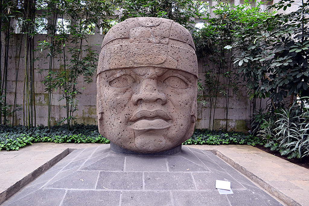
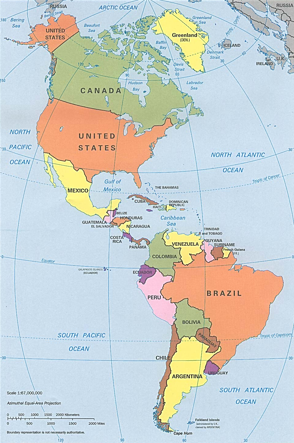
| | | | All of the 17 confirmed colossal heads that have been discovered remain in Mexico, mostly in museums, and each is carefully documented and photographed. As an illustration of one in near-perfect condition, we can show San Lorenzo Colossal Head #1 (Photo by Mesoamerican), which dates from 1200-900 BCE. We use it just to illustrate the art form, since it's rather spectacular, and the second largest at 2.84 m (9.3 ft) high and 2.11 m (6.9 ft) wide, weighing 25.3 metric tons (27.8 US tons). In case its size isn't obvious, compare it to what seems to be a notebook someone's left at the site. | | | | It's generally accepted that they are portraits of rulers, perhaps dressed as ballplayers. The heads are very individualized, and no two are alike. The helmet-like headdresses are also adorned with personal or group symbols, and were carved from single blocks or boulders of volcanic basalt. To further illustrate the size of the heads, this is the one known as La Venta Monument 4 (Photo by Bubelka). The photo includes cutouts of two people for comparison to human size. | | | | But in recent research, I was curious to find out which head I'd seen at the MNA. Listings show there are two heads, both from San Lorenzo, on permanent display there today, #2 and #6. I was able to eliminate San Lorenzo #6 right away. It had just been excavated in 1965, and we were there in 1967, at which time it was still at San Lorenzo. In 1970 it was then temporarily on loan to the Metropolitan Museum of Art in New York for that museum's centennial. Only once it was returned to Mexico did it go to Mexico City, which proves I did not see it. So my conclusion is that the one I saw at the museum must have been San Lorenzo Colossal Head #2 (Photo by rosemania). It's 2.69 m (8.8 ft) high, 1.83 m (6.0 ft) wide, 1.05 m (3.4 ft) deep, and weighs 20 metric tons (22 US tons). | | | | Its headdress is plain, except for the horizontal band at the bottom. The head is badly damaged due to an unfinished reworking process. This process has pitmarked the entire face with at least 60 smaller hollows and 2 larger holes. The surviving features appear to depict an aging man with the forehead creased into a frown. The lips are thick and slightly parted to reveal the teeth. The head has a pronounced chin. But now I know this guy is my personal link at the museum to the Olmecs. | | | | South America The year 1967 took care of our visiting Maya and Aztec sites, but it was a much longer wait, to the current year, to visit the major Inca sites in South America. To reorient ourselves, let's look at a couple of maps we saw on the Ecuador trip two years ago. These are the Americas, so we can compare the distance to the Yucatan and to central Mexico with the Central Andes. We also remind how it's the west coast of South America that lines up north-south with the east coast of North America, so a seven-hour flight doesn't really cross any time zones, avoiding jet lag. It's a daylight flight south to Lima, and an overnight flight back to New York. | | | | There's just one thing. New York, Ecuador, and Peru are all in the same Eastern US/Canada time zone, actually UTC (GMT)-5, while Bolivia, further east, is on what we'd consider Atlantic time, UTC-4. But in the northern summer, New York goes on that pesky daylight savings time, which moves it, in practice, to the Atlantic time zone. So if one travels in the northern winter, New York time would equal Ecuador and Peru's. But if we go during New York's daylight savings time, which we did both to Ecuador and now, New York is the same as Bolivia, so there is still that same one hour flip-flopping during the trip.
http://www.ezilon.com/maps/images/SouthAmerica_phy1.gif
| | | | Let's also review the Andes again (click), which can be divided into three sections, the Northern Andes in Venezuela and Colombia, the Southern Andes in Argentina and Chile, and our area of concentration, the Central Andes in Ecuador, Peru, and Bolivia, which are also most associated with the Incas. Finally, let's concentrate on the below map (click), ostensibly just of Peru, but which includes most of Ecuador and all the area of Bolivia that we need.
http://www.lib.utexas.edu/maps/americas/peru_physio-2006.jpg
| | | | The first thing to point out is what we can call "coming close" to the Inca area. In 2004, Beverly and I took that long, seven-week trip on the Caronia around South America (2013/7, Voyage 28). After exiting the Panama Canal, our travel diary says that on 29 January we crossed the equator--the closest I thought we've ever get to that Equator monument north of Quito--and docked in Manta EC (see map). On 1 February, we docked at Callao (ka.YA.o), the port for Lima PE. In each case, I took Beverly in her wheelchair for a stroll around the port area, and it was on that basis that I was able to say I'd set foot in Ecuador and Peru for the purposes of the Travelers Century Club. We then continued, and on 3 February we docked in Arica, Chile. | | | | There was a possibility at this point to go to Cusco and Machu Pikchu. A very expensive side trip was offered involving two flights and two nights in hotels, plus the tour. I rejected it out of hand, not only because of the wheelchair situation—we'd gotten around sticker situations than that—but (1) because it was a rush job, in, out, hurry, hurry--if you can't do it right, don't do it at all--and (2) it involved leaving the ship in Callao and rejoining it in Arica. If this trip was meant to be a circumnavigation, than I don't see part of that should be skipped, any more than a baseball side trip should make you miss part of the Erie Canal (2017/6). | | | | Two years later, in 2006, there were, surprisingly, two more quick visits to Lima. It was the trip to Antarctica (and Easter Island). On 9 November the flight from New York to Santiago stopped at the Lima airport, where we had a chance, surprisingly, to walk around a bit, and on 30 November, we stopped again going back. So near, and yet so far. | | | | Five years more, 2011, was the Amazon cruise as far as Manaus on 30-31 March. Our map shows the Amazon only upstream from Manaus, but we'll be making the point later that Machu Pikchu lies above the Urubamba River, which is a major tributary (see map) of the Amazon. | | | | Finally, four years later, in 2015 I felt it was time, and I tried to organize with more than one tour operator, a complete tour of the three countries. I was unsuccessful, and it's probably for the best, since two separate trips turned out better. That's when I found Amazon Adventures online, which works with local tour operators across South America, and I devised the two-trip plan. Even though the Galápagos are part of Ecuador, I considered the visit to the islands (2015/10-13) apart from that of mainland Ecuador (2015/14-17), which we conceived of instead as the first third of a visit to the three countries in the Central Andes. I'd thought a revisit would be appropriate a year and a half later, in Fall 2016, but then found I didn't have the requisite six-month validity remaining in my passport that Bolivia required. The validity was good for Canada, though, so that's how the Montréal to NYC trip evolved, followed by my renewing my passport. So the Peru and Bolivia visit was bumped ahead, and ended up falling in May 2017, just two years after Ecuador. Just as the first Ecuador posting is headed Central Andes I, for Peru we'll now have Central Andes II, and for Bolivia, Central Andes III. | | | | While Ecuador had a great deal to offer, if we're looking for just Inca heritage, I found it best in some people. We visited with the so-called Last Ice Merchant in 2015/16, and I have the best memories of the lady I called in 2015/15 "The Indigenous Woman", who took the group of us on a walk down a country lane and demonstrated the local heritage, not least, how quinoa grows and is harvested. Nice memories. But it's Peru and Bolivia that have more in the way of Inca monumental sites. | | | | Below are the major cities in the three-country region, with 2015 metropolitan area populations in millions. They're listed in the order visited:
Guayaquil EC: 2.95
Quito EC: 2.65
Lima PE: 9.90
Cusco PE: 0.435
La Paz BO: 2.36
| | | | The mainland Ecuador trip in 2015 was essentially a ride on the Tren Cucero from Guayaquil to Quito, plus the visit to the Equator Monument north of Quito (see Peru map). The current 2017 trip essentially fell into three carefully chosen segments, Lima, Cusco, Lake Titicaca. (1) I did start with a day in Lima, a large metropolis with little to see, despite a lot of history. It didn't feel right to leave it out. (2) A flight to Cusco was supplemented by a train ride to Machu Pikchu, plus a car trip to the Sacred Valley. (3) Another train ride went to Puno PE on the lake, plus a transfer to the Bolivian side of the lake for Sun Island and La Paz. It all fit in to two weeks. With the 1967 visit to the Mayas and Aztecs, it was two down, and one to go. In (2015 and) 2017, a half century later (not calculated that way by design!) we visit the Incas and I finally make my trifecta. | | | | Incas I find it difficult to place the big three civilizations on a timeline, so I looked up these dates. The Mayas were the earliest, with their Classic Period about 250-900 CE. The Aztec Empire had just reached its height at about 1500 CE, when Cortés arrived in 1519. The Inca Empire arose in the highlands of Peru sometime in the early 13C CE and lasted until conquered by Pizarro in 1572. It was the largest empire in pre-Columbian America, and possibly the largest empire in the world in the early 16C CE. Yet, according to one scholar, it was unique in many ways. The Incas had no wheeled vehicles, no animals to ride, no draft animals to do work, no knowledge of iron and steel, and no writing system.
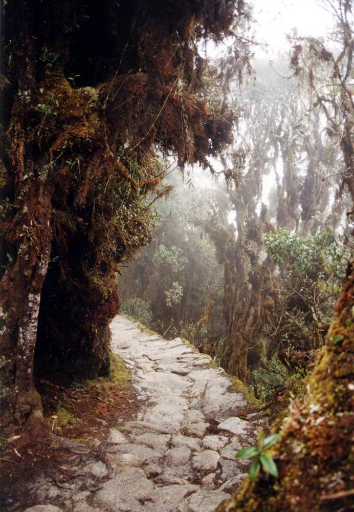
| | | | The official language of the empire was Quechua. The Quechua word Inka, spelled that way today in the introduced Latin alphabet, referred to a "ruler", "lord", or "king" and was originally applied to the ruling religious and/or governmental leader, the equivalent of the Dalai Lama or the Pope, but then generalized to apply to the ruling class or family. The Spanish adopted the word, hispanicised as "Inca" to refer to all the subjects of the empire instead. Reaching the area, Pizarro and his brothers realized they'd discovered a wealthy land, returned to Spain and got royal approval to conquer the area and become its viceroy. He had just 168 men, one cannon and 27 horses, and often managed to talk his way out of difficult situations. Yet his fully armored horsemen had great technological superiority over the Incas. | | | | Once conquered, disease struck. Smallpox claimed a majority of the Inca population early on, then came typhus, influenza, diphtheria, and measles. After the leader Atahualpa paid Pizarro his ransom in gold, Pizarro had him strangled anyway. This was parallel to how Cortés had the Aztec Cuauhtémoc killed by hanging as well. | | | | Things went differently for the Mayas. They had no single political center, and were separate states, not an empire. The Mayas had little gold and silver, which is what attracted the Spaniards. But eventually, they were attracted anyway by new land grants and labor forces. | | | | That the Spanish were successful is particularly surprising, considering the size of the Inca Empire (no attribution). It's noticeably linear along the west coast of South America, but then so are the Andes. Note in red the Cusco/Machu Pikchu area, from which it had expanded. | | | | The linearity of the empire is reflected in the extensive Inca road system (Map by Manco Capac), which featured both a mountain road and coastal roads, with connections (click). Yet perhaps the mountain road is more highly considered, and can be referred to as the Great Inca Road (Map by Laurent Granier/Megan Son), over 6,000 km (3,700 mi) long. Obviously, it was the most extensive and advanced transportation system in pre-Columbian South America, and of sufficiently good quality that remaining parts are still in good condition after centuries of use. The best known portion of the system is the Inca Trail to Machu Pikchu (Photo by Pajaro). Today, only maybe 25% of the road system is visible, since the Spaniards dug it up in some areas, or allowed it to deteriorate by the metal on oxcart wheels or horseshoes, or because modern infrastructure has replaced sections. | | | | Languages We can look at languages here on two levels. We usually think of the European languages imposed on South America (Map by Patrick87); to a minor extent, English in Guyana, Dutch in Suriname, and French in French Guiana, but primarily Portuguese in Brazil and Spanish elsewhere. But in Paraguay Guarani is also official, and Bolivia has 38 official languages, which is why Bolivia is officially named the Estado Plurinacional de Bolivia / Plurinational State of Bolivia. | | | | Which brings us to the other level, the indigenous languages (Map by Osado). These show the major ones, but there are many more smaller ones. Let's again work backwards to end with the ones most important to our discussion.
In black is Mapudungún, a language isolate (like Basque), spoken by the Mapuche people.
In green are the Mayan languages spoken by 6 million; in red is Nahuatl ("Aztec"), 1.5 million.
In yellow is Guarani, largely in Paraguay, also in Bolivia, 4.8 million.
Closer to home in gold is Aymara around Lake Titicaca in Peru and Bolivia, 3 million.
We end up in blue with Quechua, the language of the Incas, in Ecuador, Peru, and Bolivia, with 8-10 million speakers, the most widely spoken of the indigenous languages.
| | | | Quechua A quarter of the population of Peru speaks Quechua (KECH.wa) and about a third of the Quechua speakers speak NO SPANISH. I came across several guides and others speaking English and Spanish, but who mentioned their first language was Quechua. The most common of the mutually intelligible dialects is Southern Quechua (Cusco, Puno, Bolivia), with 6.9 million speakers. You may recall from when we were in Ecuador that they speak the Kichwa dialect, and spell it that way.
| | | | We said earlier we'd have Quechua words in English, such as the following, often first filtered though via Spanish: condor (kuntur), guano (wanu), jerky (ch'arki), puma, quinoa (kinwa), pisco, quinine (kina), llama, Andes (andi "high crest") Peru (pelu "river"), pampas (pampa "high plain"). | | | | The most recent time we discussed the charming word "lagniappe" was in 2016/14, at the Harper's Ferry restaurant run by a chef from New Orleans, where he was giving out beignets for dessert as a freebie, or lagniappe. The origin of this New Orleans word is unknown, although it does have a very French spelling. However, it's said to be from American Spanish la ñapa "the gift", but also thought to come in turn from Quechua yapa "something added, gift." So you never know. | | | | Spelling Quechua Place Names I have looked a bit into Quechua and have found a few points we can make, with the specific goal of understanding how best to write some place names. Anyway, a little bit of esoteric knowledge is always fun, especially when it's kept simple. I'll make reference to the standardly accepted Quechua alphabet. | | | | 1. That "unusual" Q First is the point as to whether a language has 3 or 4 voiceless stops. Stop some air with your lips, voicelessly, and you'll get a P. Do it with your tongue-tip, and you'll get a T. With the back of your tongue, you'll get a K. Thus, English has three voiceless stops, P,T,K as in "pin, tin, kin". They can have a variety of spellings, notably K which can appear in: kiss [KIS], with K; can [KAN], with C, quick [KWIK], with QU, also CK. Note that it's always the pair of sounds, KW, that's being spelled as the digraph (two letters) QU.
| | | | But some non-European languages have a fourth voiceless stop further back in the mouth than the K. Internationally, the letter Q has been chosen to represent it (not the digraph QU!), so these languages have the four voiceless stops P,T,K,Q. This "other" sound forms its own words, of course—picture English having a (fictitious) word *qin to match the other three. When outsiders see both the K and Q in those languages, they jumble them together as a K, but native speakers easily recognize the difference. We've pointed out in the past that this occurs in Arabic, which has Kuwait with a K but Iraq with a Q, Karnak with Ks, Aqaba with a Q. We also saw it in Greenlandic, with place names such as Nuuk and Kangerlussuaq, using K or Q as needed. In Nova Scotia, we even saw this phenomenon in the very name of the Mi'kmaq people. So, just as is being done today in Peru nowadays, we should also respect Quechua place names we'll visit such as Rumi Punku with K, Pisaq with Q, (and certainly not the hispanicized Písac with C!), also Wanchaq, not Huanchac. | | | | | | This brings us to the topic of one language being put into a superior position over another. A good example is Ireland, where the English adjusted place names in Irish Gaelic to English pronunciation. The most recent example of this we used was when in 2017/2 we discussed the name "Baltimore", pointing out it was originally the name of an Irish estate. Well, not quite. The name of the estate was Baile an Tí Mhóir, which English speakers adjusted to better fit English pronunciation as "Baltimore", avoiding the "pesky" original Gaelic. Question: in Peru, do you want a genuine Quechua place name, or the Spanish version of it?
Another example of one language hovering over another, and too often disrespecting it, is in a thoughtless statement such as "'Michigan' is an Indian word", only slightly improved as "'Michigan' is a Native American word". Not everyone sees the racism in not being more specific, not knowing, or caring to know, which people is involved ("they're all the same to me!"). I looked it up: more specifically it derives from Chippewa, which is another point. It's the English version, derived from the Chippewa word "meicigama", meaning "great water", a reference to Lake Superior. The ethnically respectful way to make the point is that "'Michigan' is derived from a Chippewa word." See the difference?
|
| | | | 2. K/Q and W The second point overlaps the K/Q issue, and also brings up the W issue. How useful is standard Spanish spelling as an overlay for Quechua? We touched on this in Ecuador when we said that the Quechua word kinwa is spelled "quinoa" in Spanish and internationally; that the capital city, Kitu, is spelled "Quito" in Spanish and internationally, and that the local Quechua dialect is Kichua, surprisingly similar to Spanish "Quechua". At least in these cases, Spanish does not serve Quechua well.
| | | | Spanish delights as being a child of Latin, and avoids the Greek letter K like the plague. You'll find kilómetro, kimono, Kremlin, Kennedy spelled that way in Spanish, but only because of the foreign influence. Otherwise, to represent K, Latin C reigns in most instances: clase, coñac, casa, cosa, cuña, that is, before a consonant, finally, and before A, O, U. But C is inadequate for K before E or I, so the digraph QU is used (for K!, not for KW!) in words like queso, quince. | | | | What does that give us? First, that Spanish C & QU totally mask Quechua K & Q. To a large extent internationally, we can ignore this. So Quechua Inka is spelled "Inca", Titiqaqa is "Titicaca", Kitu is Quito, OK. But kinwa being written quinoa results in many mispronunciations for non-Spanish speakers. But while we keep the Spanish-cum-international spellings for famous words, locally, for places not internationally known, we should be respectful and use the Quechua version, examples of which will be coming up below. | | | | | | But I beg to offer one exception to those famous names. One of the most famous of the international names is regularly mispronounced by non-Spaniards, because of the quirks of Spanish spelling, and so I rebel. The Quechua name Machu Pikchu--notice: (PIK.chu)--is written in Spanish as Machu Picchu with the K replaced by a C before the consonant CH, as is normal in Spanish. And so, the eyes of many skip over the word, and people rhyme the two words as *Machu Pichu. To avoid this, I insist on maintaining the Quechua spelling, even on this international name, Machu Pikchu, purely for the sake of accuracy. |
| | | | The other problem with Spanish is, as a child of Latin, it avoids the Germanic W like an alternate plague. While you will find the electrical unit wat, and whisky, Washington with W, but not much else. For the W sound, Spanish relies on Latin U, so (AG.wa) is agua and (BWE.no) is bueno. This is simple, and we can all accept this. | | | | But then there's a quirk. What were actually seeing is a syllable starting with a consonant, so it's actually GWA being spelled GUA and BWE being spelled BUE. But what if there's no consonant? Spanish spelling convention requires writing a "silent" H first, so WE must be spelled HUE and WA is HUA. You may know that the Spanish word for "egg" is pronounced WÉ.vo, but is not written *uevo, but huevo as in "huevos rancheros". When talking about the dog, or the Mexican city or state, (chi.WA.wa), is not spelled *chiuaua, but instead chihuahua, somewhat startling the non-Spanish eye. On the Antarctic trip, English speakers in Argentina were mispronouncing the kick-off city of (us.WA.ya), spelled "Ushuaia", using an English SH. Local usage in Peru is now abandoning this Spanish spelling in favor of a definite W, so that what was Huanchac, the neighborhood and rail station, is now Wanchaq, and we'll see more of this. Halleluja. | | | | 3. Three Vowels This last point is more of a curiosity than anything, but you might like to know it. Depending on how English vowels are counted, General American has 14-16 vowels, British Received Pronunciation has 20, and Australian English has 20-21, and all of these are meant to be written with the five vowel letters of the Latin alphabet. This is a so-called vowel triangle (Diagram by AugPi) showing just a selection of nine English vowels. But let's not go there. | | | | Spanish has far fewer vowels. Not counting diphthongs, there are just these five (Diagram by Legalen). All vowel triangles show the human mouth, and suppose the lips and teeth on the left, throat on the right. All five Spanish vowels are also on the English chart. | | | | Open you mouth to say Ah! and you get the A at the bottom, as in "watch" or padre. A is an open vowel. Close your mouth and you have two choices, I and U, called close vowels. Push your tongue forward toward the teeth and you get I as in "police" and Lima, making I it a close front vowel. Pull it back toward the throat and you get U as in "rule" and Puno, making U a close back vowel. | | | | | | Surprise interruption: other than in borrowed words, Quechua has only three vowels, A, I, U, as in Machu Pikchu, Pisaq, Wanchaq. |
| | | | But let's complete the Spanish chart, to see how it has an affect on Quechua. We have two mid-vowels, formed halfway between either I and A or between U and A. E is a front mid-vowel as in "café" or--café. O is a back mid-vowel as in "no" or—no. | | | | Now one quirk arises in Quechua. A preceding Q causes close vowels to open up and SOUND like mid-vowels to outsiders, but not to Quechua speakers. That is, QI sounds like QE and QU sounds like QO, but only to outsiders. What could go wrong here? Spanish influence can cause Quechua words to be spelled with an E or O. For instance the Quechua word for "green" is most accurately written as qumir, but since that U sounds like an O, Spanish influence can result in the spelling qomir. | | | | It's a minor point, but has an affect on place names we'll be using. We'll be visiting in Cusco what was the most important temple in the Inca Empire. The Hispanicized spelling is the Coricancha. Perhaps you're happy with that. But it appears in a wealth of spellings flipping Ks, Qs, and Cs as well as Us and Os. I find the second best spelling is Qorikancha, but finding that the Quechua word for "gold" is quri and "enclosure" is kancha, I prefer the QU spelling in Qurikancha. | | | | The fabulous fortress above Cusco is hispanicized as Sacsayhuamán. Note the C and the HU, and compare the Quechua spelling, now very commonly used, Saqsaywaman, with Q and W. | | | | And then there's the hardest nut to crack. Cusco has traditionally had two hispanicized spellings, the other being Cuzco, the one I learned in school, but that is disappearing (although the airport code remains CUZ). Cusco is how the name will remain in Spanish and internationally. But you should know more. There are two Quechua versions for Cusco, Qosqo and Qusqu. Again, I prefer Qusqu, as being more linguistically accurate by showing the Us, but am not surprised when I see a hotel in town called the Qosqo Hostal. Or, for that matter, the Museo Inka. | | | | Andean Plateau / Altiplano We saw on the earlier map of all of South America how the Central Andes widen considerably. This is the Andean Plateau, also called in Spanish the Altiplano. Split that word in two and you'll see that the two parts are saying "high plain", an equally logical way to look at it. This, on a world map, is the Altiplano (Map by TBjornstad). It starts in southern Peru, and all of Lake Titicaca lies within it, including in the west both Puno PE and in the east, La Paz BO (check Peru map). It continues past the famed silver mines at Potosí dating from colonial times, and well beyond, then running into Argentina. | | | | We now see that, just as the Himalayas have their Tibetan Plateau, the most extensive plateau on earth, the Andes have their Altiplano/Andean Plateau, the second most extensive plateau on earth. (Spin the globe, and what goes around comes around--or, comes full circle?) The height of the Altiplano averages about 3,750 m (12,300 ft), somewhat less than that of the Tibetan Plateau, which averages 4,500 m (14,800 ft). | | | | Altiplano Drainage I know it's déjà vu all over again, but we're back to this topic. Exorheism ("flowing outward") is the drainage we usually expect, with rivers flowing out to the ocean. Endorheism ("flowing inward"), is just the opposite—water puddles up and stays local, like in the middle of a poorly-asphalted parking lot. In 2014/9 we used for Tibet this map showing the endorheic basins of the world (Map by Citynoise), and in 2015/14, I looked ahead to Peru and Bolivia, pointing out that we're going to find a couple of amazing parallels. The Tibetan Plateau corresponds to the Andean Plateau/Altiplano. Qinghai Lake (2014/9) corresponds to Lake Titicaca, and both are endorheic (water flowing inward) with minimal to no outward flow of water.
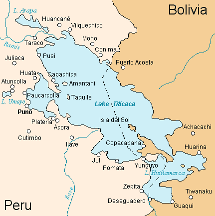
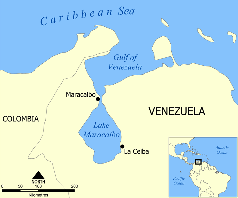
| | | | Lake Titicaca's Endorhemic System It's hard to imagine that a major, well-known lake like Titicaca has virtually no outflow. The Peru map confirms that it's not all that far from the Pacific, yet there's no connection. And since upper Peru and Bolivia both drain out to the Amazon, one could expect a outflow in that direction, but to no avail. Lake Titicaca is a huge, evaporating bowl of water the size of Puerto Rico or Corsica up on the Altiplano at 3,812 m (12,507 ft). | | | | Two separate basins make up Lake Titicaca (Map by Haylli). The larger one is perhaps 2/3 in Peru, 1/3 in Bolivia, and is the Lago Grande/Big Lake. The smaller basin is entirely in Bolivia and is the Lago Pequeño/Small Lake, although another name is also used. They are connected by the tiny Strait of Tiquina (see map) in Bolivia, only 800 m (1/2 mi) across. At its maximum, Titicaca is 190 km (118 mi) long and 80 km (50 mi) wide.
| | | | Five rivers and 20 smaller streams feed into Lake Titicaca. While 90% of the of the lake's water loss is due to evaporation caused by strong winds and intense sunlight at the high altitude, 10% does leak out, and we can use word analysis to find out where. At the bottom of the map, note the international border crossing at the town of Desaguadero, which gets its name from the Rio Desaguadero, which actually forms the border. We see –agua- in the middle, so we know we're talking about water; des- is the negative prefix like English dis- (disappear, disown) or de- (debrief, debunk); -ero corresponds to –er and a D is inserted to separate the vowels. So the word is des+agua+[d]ero, or "de-water-er", effectively "drain". This is the one and only stream that drains Lake Titicaca in any way. | | | | But not for very far, since we still have here a closed, entirely endorhemic system. This is—or was--the complete drainage area of Lake Titicaca (Map by Sayri). Click to first see the rivers feeding the lake, and then how the Desaguadero flowed into saline, shallow Lake Poopó (po.o.PO), and also Lake Uro Uro. These lakes then sent water on to huge salt flats to further evaporate. In other words, Poopó served as a catch basin for the Titicaca overflow, and the salt flats served in turn as a catch basin for Poopó. We now have the irony that water that escaped evaporation in Titicaca, ended up evaporating anyway, and all of this still within the closed system! | | | | But we've been speaking in the past tense, since this is no longer true. It's worse. Titicaca has experienced constantly receding water levels caused by shortened rainy seasons and the retraction of glaciers feeding the lake's tributaries. In December 2015, Lake Poopó had completely dried up and was declared defunct. While this has happened in the past, it doesn't appear it will recover this time. It could itself become a salt flat. | | | | Lake Titicaca's Superlatives By volume of water, Titicaca is the largest lake in South America. Before your geographic sensibilities are offended thinking about Lake Maracaibo (Map by NormanEinstein) in Venezuela, which does have a larger surface area, its name is a misnomer, since it isn't a (freshwater) lake at all, but a large brackish bay of the Caribbean, to which it is directly connected. | | | | Titicaca also has a worldwide distinction. It's the highest navigable lake in the world. Though this refers to large boats, it's generally considered to include all commercial craft. Be careful to understand this. About two dozen lakes around the world are at higher elevations, but are all much smaller and shallower, and are not navigable. | | | | Grand Plan Because of Titicaca's navigability, a grand rail 'n' sail plan was established in the 19C. While smaller ships were then connecting isolated lakeside communities, the dream was a larger connection between major cities and the Pacific. In the 1870s, the Peruvian government connected (see Peru map) Matarani on the Pacific with Arequipa by standard-gauge rail. The route then went to Juliaca, where it split, going both north to Cusco and south to Puno on the lake. | | | | | | Update: Today, freight service remains on this whole route, but Matarani/Arequipa passenger service has long been suspended, as was Arequipa/Juliaca until the recent luxury train. Cusco/Puno did have a day train, largely for tourists, for many years, but this is now taken over by the two routes, Cusco/Puno and Cusco/Puno/Arequipa, of the luxury train (discussed later). Unadvertised, inexpensive local trains with wooden seats are also available to Peruvian nationals only. |
| | | | Once the tracks reached Puno, the opportunity arose to bring in larger ships to cross the lake. How that was done was remarkable, enough so that I remember learning in elementary school about how it was done. Over time, three "knock-down" ships were designed and built in the UK, with their parts numbered. They were then dismantled ("knocked-down") with the parts shipped to Peru's Pacific coast, then carried by train to Puno, where they were rebuilt and launched. They were the SS Coya, launched in 1893, the SS Inca, 1905, and the SS Ollanta, 1931. Since they were trying to achieve service to Bolivia at La Paz, which is not on the lake, the steamer service connected Puno with Guaqui, just east of Desaguadero (see Peru map, which also shows the former ferry route). The below schedule gives this information:
http://www.nonesuchexpeditions.com/nonesuch-features/lake-titicaca-steamships/fleet-images/timetable-a.jpg
LAKE TITICACA STEAMERS
Wednesdays: The steamer will depart Puno Pier after the arrival of trains Nos 13 and 20 from Arequipa and Cuzco [old spelling], connecting at Guaqui Pier with the railcar for La Paz on Thursdays.
Fridays: The steamer will depart after the arrival of the railcar from La Paz, connecting at Puno Pier Saturdays with trains Nos 14 and 19 leaving for Arequipa and Cuzco.
There is no dining car on trains running between Guaqui and La Paz.
THE COMPANY
This schedule describes a weekly service. Since it's undated, it's unclear if service was more frequent in earlier years, though it probably was.
| | | | | | Update: The only one of these steamers to survive is the Ollanta (Photo by Alfredobi), seen here in Puno in 2003. She remains docked in Puno today, where I saw her from a distance. She had capacity for 950 tons of freight, 66 first-class passengers and 20 in second. Her length is 79 m (260 ft). She was the most luxurious steamer on the lake. I understood she was recently refurbished, which now allows her to carry 70 passengers, but since roughly the 1980s she is no longer in scheduled service, and operates by charter.
With passenger steamer traffic across the lake to connect trains now sidetracked, it is of interest that the stress is now on moving the trains themselves! Apparently the largest vessel on the lake today is the train ferry Manco Capac, named after a founder of the Inca civilization. It's equipped with dual gauge tracks to accommodate both Peruvian standard gauge (1,435 mm, 4 ft 8.5 in) and Bolivian meter gauge (1000 mm, 3 ft 3.375 in). There are also small stretches of dual gauge track in Puno and Guaqui, where car loading is done at the docks. While it would seem that this would be used for freight traffic, that remains unclear, since the most recent report I find (2013) is that the Manco Capac is berthed, and right across the pier from the Ollanta!
|
| | | | On the Bolivian end, the Ferrocarril Guaqui-La Paz / Guaqui-La Paz Railroad was completed between 1901 and 1903, giving Bolivians a useful connection to Peru and the Pacific. | | | | | | Update: With the decline of steamer travel, the Guaqui rail line to La Paz, to my knowledge, has no passenger service, since Guaqui is just a railhead and port and hardly a destination. The former La Paz rail station, which I visited, has other uses. I won't be specific until we get there, but will just say this as a teaser: gondola cable cars. (!!!) |
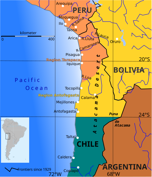
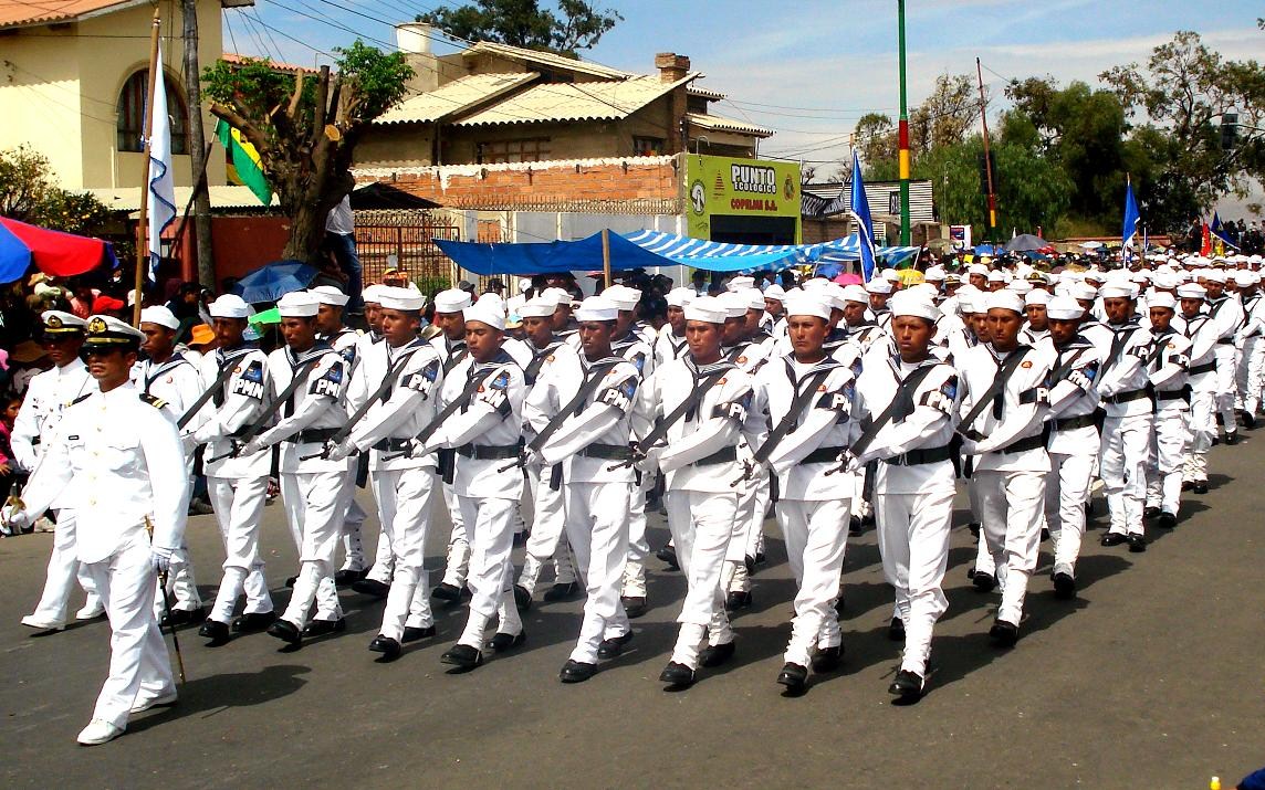
| | | | Atacama Border Dispute When discussing Peru and Bolivia, the issue of the Atacama Border Dispute has to be raised, especially regarding Bolivia. The name derives from the Atacama Desert (Map by cobaltcigs), shown here in yellow, comfortably within the borders of Chile--its arid outlying areas are in orange. The Atacama is a plateau along the Pacific that is the driest non-polar desert in the world. Its aridity is based on it lying between two mountain ranges, the Chilean Coast Range on the west and the Andes on the east. Each one is high enough to cast a two-sided rain shadow, preventing moisture from reaching the Atacama from either the Pacific or Atlantic. In addition, the Atacama is rich in mineral deposits, including gold, silver, copper, iron, and many others. And here the plot thickens. | | | | Into the mid 19C, the desert was shared by Peru, Bolivia, and Chile. But a conflict broke out between them, largely over mineral rights, known as the Guerra del Pacífico / War of the Pacific and lasted from 1879 to 1883. Peru and Bolivia were allied against Chile, but Chile won, which is why we just saw the entire Atacama "comfortably within the borders of Chile". We can see here the changes of territory (Map by Createaccount). Peru used to have a narrow tail extending into the northern part of the Atacama, including Arica. Bolivia, landlocked today, had a seacoast in the central Atacama, including Antofagasta. Chile had the southern Atacama. Now it has it all. On the Caronia trip, after the stops in Ecuador and Peru, the next stop was Arica, and that was, yes, in Chile (not that I got to see the desert). | | | | This one other map shows a bit more (Map by Ummowoa) of the changes. The stripes show that the upper Atacama had been Peru (cream), but is now Chile (blue). The middle Atacama had been Bolivia's only coastline (green), but is now Chile (blue). But in addition, it shows that the lower non-coastal region had been Bolivia (green), but is now Argentina (brown). | | | | It's been said that "in Peru, the wounds run less deep than in neighboring Bolivia", particularly since Peru already has an extensive coastline, but in Bolivia it remains a current issue, even an obsessive one. While the treaty give Bolivia the right to tax-free transport of goods to the ports, and required Chile to build two rail links, La Paz-Arica and La Paz Antofagasta, Bolivia remains resentful and emotional having lost its former coast. People believe a lot of the country's problems are because of their being landlocked. Bolivia has pressured Chile about the problem, and Chile's reaction seems to be "live with it". | | | | I've found this picture of a monument in Bolivia (Photo by Dentren) near the modern Chilean border on the Atacama. A figure points to the sea and says Lo que un día fue nuestro / nuestro otra vez será (What was once ours / will be ours again.) The other quote makes reference to a roto, a nickname for a Chilean. The word has connotations of Everyman, is used pridefully in Chile, and contemptuously in other Spanish-speaking countries, especially Bolivia and Peru. Below the two fighting soldiers it says Agárrense, rotos, que aquí entran los Colorados de Bolivia (Hold tight, rotos, Bolivian Redcoats are on the way). It would be hard to believe that this matter is settled in Bolivia. | | | | In 1975, the Chilean government made a proposal to Bolivia, offering to swap a narrow, continuous corridor (Map by B1mbo) of what is now Chilean land just north of Arica and along the Peruvian border in exchange for a piece of the same amount of Bolivian territory. But this corridor had been Peruvian land, and according to the treaty, Chile could not give former Peruvian land to others without Peru's agreement. The dictator of Peru was against this, and instead proposed to make Arica a territory governed by the three countries, a solution that Chile found too complicated. Since then, Bolivia and Chile have maintained relations only on a consular level. Now, with new leaders in both countries, relations have improved, but the border dispute is still pending. | | | | An indication that Bolivia takes the seacoast matter seriously is shown by the fact that the Fuerzas Armadas de Bolivia / Bolivian Armed Forces maintains a branch called the Armada de Bolivia (AB) / Bolivian Armada, also called the Fuerza Naval de Bolivia (FNB) / Bolivian Naval Forces. This is a parade of the Naval Military Police of Bolivia (Photo by Israel_soliz). Given that it is primarily a lake and river force, it doesn't have an ocean fleet. It centers its operations on patrolling and giving logistical support to building shipyards and maintaining its ships. Waiting for the hydrofoil in Copacabana, we saw a naval unit marching, and the next day, when the hydrofoil wanted to pass through the narrow Strait of Tiquina from the Big Lake to the Small Lake, the captain had to signal the naval unit on the shore and wait until they signaled back with a flag for permission. We'll also see below that the Bolivian coat of arms still maintains a tenth star for the missing coastal province. | | | | Altiplano Camelids We'll end this Central Andes introduction discussing the cuddly creatures among the local fauna. Don't be concerned about that scientific word. Just as hominids relate to humans, camelids relate to camels, and we know what camel-like creatures this area is famous for. There are actually four of them that are all rather similar, but that are commonly recognized as being distinct species, despite the difficulties of defining their distinctive characteristics. These are the llama, alpaca, vicuña, & guanaco.
| | | | The llama and alpaca are only known in the domestic state, and are variable in size and of many colors, being often white, brown, or piebald. Some are grey or black. In Peru and Bolivia, you see them all the time. I have trouble telling them apart.
The vicuña and guanaco are wild, and of a nearly uniform light-brown color, passing into white below. Since they are wild, you "never" see them.
Let's first eliminate the two no-shows, the wild ones you don't really get to see.
| | | | This is a guanaco (Photo by fainmen). Its range is largely out of our area (Map by Udo Schröter)—while guanacos do live in the Altiplano, they are far more numerous in the pampas of Argentina.
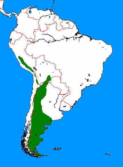
| | | | This is a vicuña (Photo by Alexandre Buisse [Nattfodd]), whose range fits right in to the Altiplano (Map by Udo Schröter). The vicuña has a long, wooly coat that is tawny brown on the back, but white and quite long on the throat and chest. It's the national animal of Peru, and appears on Peru's coat of arms. It's believed to be the wild ancestor of the domesticated alpaca. Soft vicuña wool is highly prized, but it's expensive, since it's a wild animal and has to be caught, and can be shorn only every three years. The name is pronounced vai.KU.nya, although many English speakers tend to misplace the Y and say *vai.KYU.na.
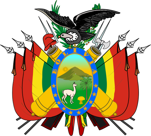
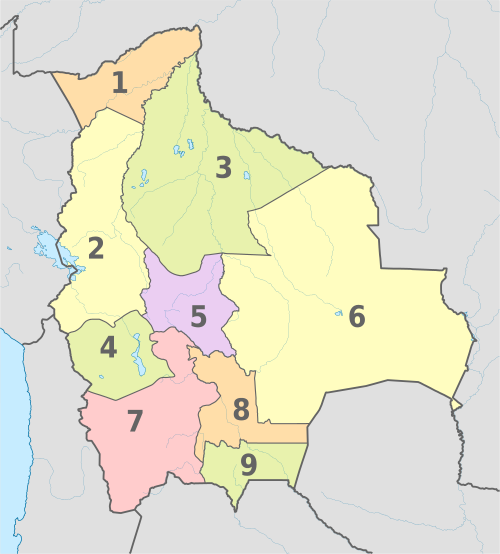
| | | | The two domesticated camelids are llamas (Photo by Anakin) and alpacas (Photo by Sizzlingbadger). You can hardly avoid seeing them around, partly because they're as common as sheep would be elsewhere in rural areas, but also because they're paraded in town for tourists to see and photograph. They've even brought a llama or two to parade around the ruins at Machu Pikchu, where they really do not fit in, but apparently add to the "tourist atmosphere". I continue to have trouble telling llamas and alpacas apart, even when they're in the same pen, which is not uncommon. Alpacas are smaller, but I'm still confused by a younger llama versus an alpaca. Perhaps alpacas give a squatter appearance. | | | | Llamas are very social animals and live together in a herd. When used as a pack animal, they can carry about 25-30% of their body weight for 8-13 km (5-8 mi). Oddly, it was on the central plains of North America where llamas appear to have originated about 40 million years ago, and only migrated to South America about three million years ago. By the end of the last ice age, 10,000-12,000 years ago, camelids were extinct in North America, but there are today over seven million llamas and alpacas in South America. And yes, I've seen llama and alpaca meat appear regularly on restaurant menus. No, I never ordered it. | | | | We made reference above to the Bolivian coat of arms (Image by Caleb Moore). We can point out now that it shows an alpaca (and an Andean condor at the top). But note that the central cartouche has a border with ten stars in the bottom. Nine of the stars symbolize the nine Departmentos of Bolivia (Map by TUBS), but the tenth star continues to symbolize Litoral, the Departamento on the coast lost to Chile in 1879. | | | |
| |
|
|
|

