|
Reflections 2021
Series 9
November 5
Switzerland: the Fundamentals – "Locus+Visit"
| | In the previous posting we spoke of breaks of gauge and gauge changers, primarily the one built by Talgo for broad and standard gauges. We only touched a bit on the other one I want to discuss, the one built in Switzerland by the MOB railway for narrow and standard gauges. But the topic of Switzerland easily expands to the point that we first need to talk about some of the fun fundamentals worth knowing about Switzerland, since there's so much to say about it and we really haven't said too much about it recently, other than my surprise at passing thru it on the VSOE.
So we'll be more expansive in this posting. And in the next one, follow a very enjoyable rail trip I did in Switzerland in 2008 to see what we can about any breaks of gauge, and then move on to complete our discussion of the magic of gauge changers.
| | | | The Fundamentals First I think it best that we have a really good relief map of Switzerland (click) to make sure we know where all those mountains are (Map by Tschubby). Once we're clear on that, we can see how the country grew and got some of the craziest, most irregular borders in Europe and how it grew from a German-speaking country to have major areas of other languages, to the point that many people picture it as a tri-lingual country.
Picture it this way: its three geographic regions appear to lie at a 30° angle spreading from Geneva (Genf) eastwards. In the northwest is the first region, the sub-alpine Jura Mountains, running from Geneva to south of Basel—but they're shared with France (we'll see why later), and a bit with Germany. In English, Jura rhymes with juro[r]; French Jura is zhü.RA; German Jura is YU.ra; Italian Giura is like English. The Jura Mountains gave their name to the Jurassic Period of prehistory.
Our next angular strip is very wide; it's the Swiss Plateau (GE: Schweizer Mittelland [=midland]; FR: plateau suisse; IT: altopiano svizzero). It covers about 30% of Switzerland and is mostly hilly, tho partly flat. This is also the area of lakes, lying between the two huge lakes, Lake Geneva/Lac Léman/Genfersee (shared with France) and Lake Constance/Bodensee (shared with Germany and Austria; the English name is based on the German city of Konstanz (Constance), not shown). The plateau is by far the most densely populated part of Switzerland. Here's a closer view of the Swiss Plateau taken by NASA. The 30° angle is particularly noticeable here.
And the final strip is of course the Swiss Alps (GE: Schweizer Alpen; FR: Alpes suisses; IT: Alpi svizzere). And one has to be specific, since the range of the Alps is much larger than just Switzerland, as seen here (Map by Drat70). The Julian Alps are in Slovenia; since the German Alps are in Bavaria, they're more often called the Bavarian Alps; the Alps in tiny Liechtenstein (not named) are usually envisioned as Swiss or Austrian. As it turns out, only 14% of the Alps are in Switzerland, but when counting the Alpine four-thousanders (mountains that are at least 4,000 m [13,123 ft] tall), of which there are 82, 48 are in the Swiss Alps, and almost all of the other 34 are within 20 km (12 mi) of the Swiss border. In addition, since the Alps cover over 60% of Switzerland, it's one of the most Alpine of countries.
And also check south of the Alps, where there's another cluster of lakes, usually called the Italian Lakes. But that's not entirely accurate, since, among the larger lakes, Lake Lugano / Lago di Lugano / Luganersee (click) is two-thirds (63%/37%) in Switzerland (Map by Civvì). Also in Switzerland is, by eye, about the top fifth or so of Lake Maggiore / Lago Maggiore (Greater or Major Lake), German Langensee (Long Lake) (Map by Tschubby). The large unnamed lake to the east that looks like a person running is Lake Como/Lago di Como/Comersee, and off the map much further to the east is Lake Garda. These, plus smaller lakes, are indeed all Italian.
| | | | Helvetia & Rhaetia It's common knowledge that "Helvetia" is a reference to Switzerland. I always thought it had been the name of a Roman province, but, as Humphrey Bogart famously said in Casablanca, "I was misinformed". Or, more likely, I misinformed myself by making an assumption and jumping to a conclusion. | | | | | | Bogart was a native Nu Yawka, and actually said "misinfawmed". You can check it out here. |
| | | | The Helvetii (hel.WÉ.ti.i), anglicized as Helvetians, were a Celtic tribe occupying most of the Swiss plateau at the time of their contact with the Romans in the 1C BCE. Named after them is Helvetia (hel.VI.sha), the female national personification of Switzerland, whose official name is actually in Latin, Confoederatio Helvetica, the Swiss Confederation. For this reason, Swiss ID stickers on cars say CH, and Swiss websites end in ".ch". The figure of Helvetia is used on postage stamps and coins. This shows a two-franc Swiss coin. Using "Helvetia" solves the problem of choosing between three (or four) languages, and writing simply "2 Fr." solves the problem of having to say zwei Franken, deux francs, due franchi. As on the US flag, where stars represent states, the number of stars around Helvetia represent the 26 cantons. But if you count them on this coin, you'll find only 23 stars. That's because little involving Switzerland is simple. There were 23 cantons until the constitutional change of 1999 (this coin is dated 1995), when three cantons that actually consisted of half-cantons (yes, really) had those made full cantons, raising the number to 26. | | | | | | It's worth noting that equivalent translations of "Helvetia" still serve as the name for Switzerland in some languages.
In Romanian, Switzerland is known as Elveția (ț = ts);
In Greek, it's Ελβετία / Elvetia;
In Irish Gaelic, it's An Eilvéis;
In Italian, the name Elvezia is now archaic. However, the noun/adjective form elvetico is used very commonly as synonym of svizzero. We'll see an example of this later.
|
| | | | So what about Roman times in Switzerland? This is the Alpine region around 14 CE. You can judge where Switzerland is today by comparing Lacus Lemanus (Lake Geneva, French: Lac Léman) with Lacus Venetus (Lake Constance, German: Bodensee). Genava is of course today Geneva. Viviscus is Vevey. The Rhenus is the Rhine. The other names on the map are not helpful to identify locations. In any case, you can see that the Helvetii tribe was located right on the Swiss plain. However, today's Switzerland was divided between the Roman provinces of Gallia Belgica and Raetia et Vindelicia. So let's now move up almost 14 decades to see the same area in 150 CE (Both Maps by Marco Zanoli). At this point the provincial names have shifted to Germania Superior and Raetia, and alternate spelling of Rhaetia. Thus if one wants to make a reference to Roman provinces in Switzerland, Helvetia has nothing to do with it. Rhaetia would do it, particularly in eastern Switzerland, where the most prominent narrow-gauge railway is called the Rhätische Bahn / Rhaetian Railway, so I finally get to figure out the origin of its name. As for pronunciation in English, the weird and varying spellings of [Helv]etian, [Rh]aetian, and [Gr]ecian are all the same, so they rhyme. | | | | Medieval Origins Among the basics we need is how Switzerland became a country. That part will include the legendary Swiss figure everyone knows about already, William Tell, but also about the three original cantons, how they wanted independence from royalty, and how they expanded to encompass other languages than German. | | | | The Name Before we look at maps, let's start with words, and words will bring history and geography together. There's a small town in the middle of Switzerland called Schwyz (ShVITS, rhymes with "eats"). That name first appeared in 972 in its Old High German form Suittes, possibly related to the OHG swedan "to burn", in reference to the area of forest that was burned and cleared in order to build a settlement. You'll see the forest theme thruout this early history. The name Schwyz was then extended to the entire canton of which the town was the capital, and the canton of Schwyz was one of those three original ones, with Uri and Unterwalden. Jumping way ahead for a moment, as of the 16C with much further expansion, the name Schwyz was extended to the whole country, in the form it still has today, Schweiz (ShVAITS, rhymes with "sites").
Now the demonym (name for a person) today is Schweizer (for a woman Schweizerin), which follows the same pattern that's used by both English and German for London/Londoner, New York/New Yorker / Berlin/Berliner, so keep that –ER suffix in mind.
English in the 16C-19C did use a demonym borrowed from German, "Switzer", which is now obsolete in English. That term was then compounded with –land for the country, indicating logically that a Switzer is a person from Switzerland. (Note that English is the only language that uses "land" as part of the country name.) Anyway, now we can regard the English name "Switzerland" as having three morphemes (meaningful elements): switz- derived from the German name; -er to make it a person; -land to make it a place.
| | | | | | Note these developments in family names:
Albert Schweitzer (a T is added to the spelling) was the German medical missionary and winner of the 1952 Nobel Peace Prize.
On a much less esoteric level but still of linguistic interest, the child actor in the Our Gang comedies who played Alfalfa was Carl Switzer, with a surname based on the older form of the word.
|
| | | | The French name of the country is Suisse (SÜIS, rhymes with "geese"). Oddly, it's also the male demonym (a woman is a suissesse). A French online source claims that the name of the village of Schwyz once appeared as "Swis", hence French Suisse. This source didn't mention a reference, so I'm inclined to modify the statement. I would say that Schwyz never appeared as Swis on its own territory. I'm going to presume that Swis was an early French interpretation of Schwyz, meaning that that altered name appeared as such in French sources only. It's the only way I can accept that explanation.
But here's the weird part. While English "Switzerland" is taken from German, as explained above, the English demonym "Swiss" is obviously taken from the French (male) demonym Suisse. It happened as of the 16C, pretty much at the same time. Language can be funny that way.
For the sake of completion, the country names in the other two official languages are Svizzera (ZVIT.tse.ra) in Italian and Svizra (ZhVI.tsra) in Romansh (which we'll discuss later). Just analyzing these four versions of the name we can say that German and French are parallel, since Schweiz and Suisse are not only monosyllabic, which is trivial, but both make reference only to the town name Schwyz and nothing more. English Switz+er+land includes the three elements mentioned above. So does Italian Svizz+er+a, noting that country names often end in A in Italian (Italia, Francia, Germania). Even Romansh has three: Sviz+r+a.
| | | | Old Swiss Confederacy After the Roman period, what we've mentioned so far fell between a millennium and a half-millennium ago, because that's when the basics of Swiss history occurred. Also, because of that, some facts are definite, and others less so, which explains why William Tell is a legend, and why facts about the Old Swiss Confederacy are also a bit hazy. Because of complexities, we'll be jumping back and forth in time a bit, as you've already seen, having already made references to 972 and up to the 19C.
Let's take a look at this map of the Old Swiss Confederacy as of 1315 (Map by Marco Zanoli). As we said, Schwyz (gold), Uri (orange) and Unterwalden (yellow) had joined together as an independent republic free of royalty. (The thin red line connecting blue rivers is the modern Swiss border.) The Bundesbrief von 1291 / Federal Charter of 1291 is considered the founding document of Switzerland, and the day that year that it was signed, 1 August, is today the Swiss National Day. This and other documents can be considered parallel to various founding documents of the United States. This early alliance is referred to as the Alte Eidgenossenschaft / Old Swiss Confederacy and it's the the precursor of the modern state of Switzerland. It lasted until Napoleonic changes came about in 1798.
| | | | | | Tho changes occurred after this period, the term Eidgenossenschaft remains with us to this very day, almost as another name for Switzerland, and in use since the 14C. However, it's use is Swiss-specific, and is used only by German speakers in Switzerland, tho usually recognized by those in other German-speaking countries.
Genossen are comrades. The suffix -schaft is like English –ship, so that a Genossenschaft is literally a "comradeship", but corresponds to a confederation. An Eid is an oath, and the two words are directly related, altho it may not seem so. So finally we come to the ultra-Swiss word for the country, the Eidgenossenschaft. It's awkward to translate, but consider it an "oath-comradeship"; it's a confederation based on the original oath to unify. Without Eid, the French equivalent is Confédération and the Italian is Confederazione, so English can also use "Confederation". However, none of these carry the nuance of it being based on an original oath.
The word is pervasive. Swiss citizens can jokingly be referred to in German-speaking Switzerland as Eidgenossen, particularly to contrast them from the numerous immigrants. And the adjective eidgenössisch, corresponding to "Swiss Federal", is regularly used for Swiss institutions: the Eidgenössische Technische Hochschule is the Swiss Federal Technological Institute.
|
| | | | Now continue to keep in mind the importance of that oath in the founding of Switzerland, and also the very early date involved, 1291. We now come to the Rütlischwur, 16 years later in 1307. In German schwören is to swear (clearly related words between the two languages) and a Schwur, literally a "swearing", is another word for "oath". The fact that these two dates are not the same shows that the chronicles from centuries ago do not agree on a number of details.
On the other hand, the Rütli is a place. And it's not a town, but an Alpine meadow—even the name means "small clearing" in the woods. For the sake of convenience, we'll reprint this earlier map of the three original cantons. If you click in the center, you'll see that the Rütli is physically in Uri, on the west shore of the Vierwaldstättersee / Lake of Lucerne. The legendary belief is that the actual oath took place here on the Rütli, altho, given the vagaries of the old chronicles, that might be more wishful thinking than fact. It isn't known exactly when or where the representatives of the three original cantons declared the oath of unity. A 1477 source even names the legendary Wilhelm Tell as der erste Eidgenosse / the first oath-taker (= the first Swiss) but that's contradicted elsewhere, making it more wishful thinking. And as an additional odd quirk, both French and Italian call the Rütli the Grütli, and I can find no source for that initial G.
While I've never visited it, I did have an excellent view of the Rütli when I took a steamer on the Vierwaldstättersee (Photo by MatthiasKabel). The woods around it indicate its being an old clearing; it covers 5 hectares (12 acres). Click to (barely) see the red-and-white Swiss flag, a reflection of the fact that it's a national monument and a place of annual celebrations on 1 August, and is referred to as the Wiege der Schweiz / Cradle of Switzerland. Over time, the Rütli has been visited by Friedrich Schiller (who wrote his play "Wilhelm Tell"), Queen Victoria, and Mark Twain. This sign (with an equally limp flag) is self-explanatory and shows the variation Grütli in French and Italian, while Romansh apparently uses the standard form (Photo by DrHäxer).
The 700th celebration of the 1291 founding of Switzerland occurred here in 1991, at which time a hiking trail was inaugurated (the Swiss and many other German speakers are enthusiastic hikers), called the Weg der Schweiz, Voie Suisse, Via Svizzera / Swiss Path. It loops around the Urner See / Lake Uri. (Uri takes the form Urn- with an ending; a person from Uri is an Urner). Note that this view is to the SOUTH, thus "upside down". The Urner See is the name of this narrow branch of the Vierwaldstättersee. The Path starts at the Rütli and, at Flüelen, is close to Altdorf, the village associated with Wilhelm Tell (both towns are also on the three cantons map). The total length of the trail is about 35 km (22 mi), and takes 2 or 3 days to complete.
Waldstatt A term first used in 1289 to refer to each the three original cantons of the Swiss Confederacy is Waldstatt (VALT.shtat) "forested site", plural Waldstätte (VALT.shte.ta). That developed as follows. Today, Wald and Forst are pretty much synonyms, much like "woods" and "forest" in English—and I'm sure you see they're all cognates, or related words. (However I feel that both "woods" and Wald are more common in everyday use.) But in Middle High German terminology, the two words were contrasted. Wald referred to woods alternating with fields and pastures, a more cultivated, civilized, inhabited image, while Forst referred to a deep, uncultivated forest, a darker, more dangerous, and fearful area. In time, the settlements within the cultivated, yet still wooded, areas began to be described as Waldstätte.
As ongoing territorial expansions took place, newer additions were also called Waldstätte. When Luzern (Lucerne) became one in the 1450s, it was realized that what had up till then been called the Luzerner See (English still calls it the Lake of Lucerne) was now surrounded by four cantons (out of many more), and as of the 16C, it began to be called the Vierwaldstättersee, which corresponds literally to the "Lake of the Four Forest Settlements", but is commonly translated as the "Lake of the Four Forest Cantons". French uses lac des Quatre-Cantons and Italian uses lago dei Quattro Cantoni, however both those languages neglect mentioning the forest factor, which is actually so essential in early Swiss history.
| | | | | | We should add here what happened to one of the original three cantons, Unterwalden ("among the forests"). Just when it split is not clear, but it was over the course of the 14C-15C that it broke down into two upper-and-lower parts, Obwalden ("upper forest") and Nidwalden ("lower forest"). (The prefix ob- is short for ober, über indicating "over, upper", while nid- is connected to nieder "low, nether, 'neath"—think Niederlande.) For many years, they were considered "half-cantons" each with a federal half-vote. However, the name Unterwalden was omitted in the 1999 constitution, with Obwalden and Nidwalden named as two separate cantons. Thus the "original three cantons" now appear as four—but you have to understand the history. (There were also two other pairs of half-cantons.)
Americans should keep in mind that what was Carolina (and often is still referred to as such) became North Carolina and South Carolina while still colonies. What was Virginia saw Kentucky break away peacefully and West Virginia break away during wartime. One can surely cite other examples in the US and elsewhere.
|
| | | | This is the very irregularly shaped Vierwaldstättersee (Map by Tschubby). Circle clockwise from the top to find Schwyz, Uri, Unterwalden (now split into Nidwalden and Obwalden), and Luzern. Since the lake is so irregular, it's sections tend to have their own names, and we saw that the section in Uri is known as the Urner See.
Later still, the term Waldstatt was gradually replaced by Ort ("location, place"). It wasn't until around 1650 that that, too, gradually became supplanted by the Latinate term Kanton (canton), the word that remains to the present. But as a matter of style, when you want to evoke the misty pasts of Swiss history, you again return to talking about Waldstätte, Eidgenossen--and William Tell.
| | | | Wilhelm Tell The part of this story that everyone knows, probably since childhood, is the story of William Tell, the Swiss legendary folk hero who's internationally known and whose story is surely digested by young children along with fairy tales.
For the record, here's the fullest version of the story (many exist), written by Aegidius Tschudi c. 1570, only the beginning of which is usually well-known. Tell was an expert marksman with the crossbow who was visiting Altdorf with his son Walter in 1307 (the same year as the Rütlischwur). They were both arrested after refusing to salute the hat on top of a pole belonging to the tyrannical Habsburg official Albrecht Gessler. Knowing Tell's marksmanship, Gessler's punishment instead of executing both of them (!) was the famous arrow shot using the apple. After its success, Gessler wondered why Tell had a second arrow, and was told it would have been for him, had he missed. Gessler was furious and arrested Tell and sent him by boat to the castle in Küssnacht, on the totally opposite end of the Vierwaldstättersee / Lake of Lucerne, close to Luzern (Lucerne)—both are shown on the lake map above. But Tell escaped, was still pursued on foot by Gessler, and finally did kill him with the second arrow on a road near Küssnacht.
But the earliest accounts (1474, 1501) don't agree with all the facts, including that Gessler was killed. The additional details found in Tschudi's account are suspect, since he is known to have habitually filled in holes in stories with further details that may be of his own invention. These include that Tell's given name was Wilhelm, the name of the town he was from (not Altdorf), and the exact date (!), 18 November 1307, of the apple-shot.
So it's a great story, but its events are not substantiated by historical evidence, and much of it is the result of folk tales. Both the Tell and Rütlischwur stories are generally considered a fictitious glorification of the independence struggles of the three original cantons. Still, the story of Tell's defiance and his tyrannicide encouraged early Eidgenossen to rebel against foreign rulers, notably the Habsburgs.
There is ample iconography of the Tell story, in Switzerland and elsewhere. This is a 1901 mosaic on the façade of the Swiss National Museum showing Tell's arrest (Photo by Roland zh). The grouping at the left are locals bowing to the hat on the pole. In the center are three men-at-arms arresting the Tells. And on the right is a defiant, unbowed Tell. Depicted on a 1507 woodcut, then reprinted in a 1554 book, is this depiction of Tells Apfelschuss / Tell's apple-shot. And this is the 1895 William Tell Monument in Altdorf. I believe I've seen this monument, but am not totally sure.
| | | | Tell in the Arts We just mentioned that one of the major works by Friedrich Schiller is his play Wilhelm Tell (remember, he visited the Rütli for source material). This is a view of the first edition (Attribution: Foto Wikimedia H.-P.Haack). It includes a hand-colored copper engraving, and, somewhat amusingly in the center of the title page, above the date of 1804, it says: Zum Neujahrsgeschenk auf 1805 / "As a New Year's present for 1805".
The other work that comes to mind has an unusual provenance. Gioachino Rossini wrote his opera about Tell 25 years later, in 1829, basing it on Schiller's play, which in turn is based on the legend. But while you'd expect it to have been named Guglielmo Tell in Italian, it was named Guillaume Tell in French, since he wrote the opera in French, a fact which is new to me as we speak.
| | | | | | This is less odd than one might imagine. For instance, German-speaking Mozart wrote Così fan tutte in Italian, and Italian-speaking Donizetti wrote La fille du régiment in French. |
| | | | But I suspect many people are unaware that the Tell opera exists. I understand it runs for an insufferably long four hours (and is usually cut when performed), and the music is difficult to sing. But mostly I suspect it's because its overture has overwhelmed the rest of the piece, and indeed, the William Tell Overture has taken on a life of its own, most often played as a free-standing piece, and one of the most favorite—and most parodied--light selections in the classical repertoire.
The whole William Tell Overture (WTO) runs for about 12 minutes, and what's unusual about it is that it's (1) in four parts, like a symphony, and that (2) the four parts are performed in immediate succession with no pauses whatsoever in between. Therefore, each part runs about 2-3 minutes. I remember that, when we studied it in 6th grade Music Appreciation, the teacher described the parts as "Dawn, Storm, Calm, Finale", which was easy for kids to remember. I now learn she made a minor adjustment in the names. The overture is meant to paint a musical picture of life in the Swiss Alps, to establish the setting for the opera. You can just picture it all happening on the Rütli or anywhere along the Vierwaldstättersee. Its four parts are as follows. Note that they alternate from peaceful to dynamic to peaceful to dynamic.
(1) "Dawn" can also be referred to as the Prelude, but I prefer picturing the quiet dawn imagery of the sun rising over the Alps that it illustrates musically. It was written in a slow tempo for the cello section (with five soloists), the double basses, and the timpani.
(2) The "Storm" is a dynamic section played by the full orchestra with backup from the trombones. As this section starts, the violins and violas show the wind picking up. Added to this, the first raindrops start falling slowly, one after the other, in groups of three—plink, PLONK, plunk—plink, PLONK, plunk--first performed by the piccolo, flute, and oboes, then expanded on by the clarinets and bassoons. And then POW!!! the full strength of the storm hits with the entrance of the French horns, trumpets, trombones, and bass drum. But these intense, sudden summer storms don't last long, and in short order the storm abates, and the number of instruments decreases, as well as the overall volume. Then we're back to a final few rain spatters—plink, PLONK, plunk—plink, PLONK, plunk. The section ends with the flute playing alone for a few notes—perhaps a bird appearing—life renewing--as the sun comes out. It's a perfect segue to the so-called "calm".
(3) The "Ranz des Vaches" is the official name of the third section. I can see why Mrs Lindner in 6th grade referred to it as the "Calm" after the storm. I looked up the French term and the explanation is coupled to the German term Kuhreihen. Other than the fact that each term refers to cows, that's not too helpful. A further explanation is that both terms refer to simple melodies traditionally played on the horn (or, from another source, sung a cappella) by Swiss herdsmen driving their cows to and from the pastures. If you must have a translation, it's something like a "call to the cows". But then the meaning goes much deeper. They are such typical, traditional melodies that they notoriously cause deep nostalgia in the Swiss, especially those who are away from Switzerland. This nostalgia is referred to as Schweizerheimweh / Swiss homesickness or mal du Suisse / Swiss sickness. So the fuller explanation shows us that, after the dawn and storm, Rossini offered a section appealing emotionally to the Swiss, and very pastorally to outsiders. Actually, a good name for this section would have been the "Pastorale". It features clarinets, English horns, and the flute.
(4) The "Finale" is the section of the overture that's taken on a life of its own beyond the fact that the whole overture has taken on a life of its own from the opera. While the Storm is described as dynamic, the Finale is described as "ultra-dynamic". While a gallop is the fastest gait of a horse, when spelled galop (in most languages, but Galopp in German) it refers to a lively country dance dating to the late 1820s. (An even livelier, faster version of the galop was the can-can developed in Paris around 1830.) Keeping that fast speed in mind (and you can't forget the can-can), the Finale is described as an ultra-dynamic, high-energy "cavalry-charge" galop, and is played by the full orchestra, led by trumpets and horns. Only now have I learned that the Finale can also be called the "March of the Swiss Soldiers", and alludes to the last act of the opera, which recounts the Swiss soldiers' victorious battle to liberate their homeland from Habsburg repression. In other words, the spirited Finale foreshadows the spirited climax of Swiss independence, as reflected in the folk hero, Tell.
The opening of the Finale is unforgettable, especially as it just barely overlaps the last quiet notes of the Ranz des Vaches: Toot!! Toot-a-Toot!! then on and on until a second Toot!! Toot-a-Toot!! continues the theme as the soldiers arrive to save the day.
Tho there are no horses or cavalry charges anywhere in the opera, the Finale of the overture is often used in popular media to denote galloping horses, a race, or a hero riding to the rescue—that is, anything thrilling. When you realize that the rapid galop style is based on the horses' gallop, that becomes completely understandable.
| | | | | | Of course, in the world of US popular entertainment, the Finale became familiar thru its use as the theme music for the Lone Ranger in radio, television, and film. Yes, as a very small child, I listened to the early evening 15-minute radio programs of the Lone Ranger and Tonto riding their horses Silver and Scout. And I'm sure I kept time to the theme music via hands on knees. It being radio, the thrilling theme music was particularly influential in becoming engrossed in the story.
I'm sure you've heard the old line about the definition of an intellectual being a person who can listen to the Finale to the William Tell Overture WITHOUT thinking of the Lone Ranger. But in a multicultural world, I'm sure that joke applies only to North America, as I strongly doubt the importance of the Lone Ranger internationally.
|
| | | | We cannot move on without a musical illustration. As a matter of fact, we'll give two. Our narrative will continue about Swiss soldiers fighting the Habsburgs, and since the Finale is about those soldiers, that's what we need to show. This is a YouTube video of just the Finale, since it's also called the March of the Swiss Soldiers (tho it's much too lively for a march!). It runs just 2:05, as Edo de Waart conducts the Milwaukee Symphony Orchestra.
But I'm sure some, seeking the rising sun, raindrops, and cows, will want to also hear the whole overture. These are all four parts of the complete William Tell Overture (11:41), with Claudio Abbado conducting the Berliner Philharmoniker. The parts start at:
0:00 Dawn; 2:40 Storm; 5:18 Ranz des Vaches; 7:47 Finale
Check out at 3:12 to see what fortuitous event causes Abbado to turn around and break out in a big smile.
| | | | Habsburg When I first heard the Tell story as a child and that Gessler represented the Habsburgs, I had no idea of what they were. In high school history, I finally learned they were the ruling house of Austria, and we remember them thru Sarajevo and WWI. Finally in my German studies, I learned that they were named after the castle where they originated, since a Burg is a castle. I then came across the information that, due to the presence of one or many hawks—"hawk" in German is Habicht (Photo by Norbert Kenntner)—the castle was originally called the Habichtsburg—let's consider that Hawk Castle--a name that lost a syllable over time to become Habsburg. But I had no idea where that castle was, presuming it to be somewhere in Austria. I now have learned better.
So we go back for a third time to the three cantons map (Map by Marco Zanoli), but this time look beyond just those three (plus all those locations on or near the Vierwaldstättersee: the Rütli, Flüelen, Altdorf, Luzern, and Küssnacht—where Tell supposedly killed Gessler, even Schwyz. The pink area, dark and light, is the territory controlled by the Habsburgs, and if you click top center you'll find the village of Habsburg, named after Habsburg Castle (Photo by Freaktalius), built around 1020, located near the Aare (two syllables) River, also called the Aar. The Aare is a tributary of the Rhine and is the longest river that's entirely within Switzerland. (Trace it back from the Rhine thru Habsburg thru Bern thru the lakes at Interlaken to Meiringen, a town we'll discuss in the next posting.) One more thing on this map is to note the importance of mountain passes in Switzerland and nearby. Start at the bottom to see the Simplon Pass, which would have the Simplon Tunnel built under it centuries after the time of this map. At the bottom of Unterwalden, note the Brünig Pass next to Meiringen, both to be discussed later. But among a cluster of passes, locate the (Sankt) Gotthard Pass, which today has three tunnels under it, as it's a major route south into Italy.
| | | | Habsburgs versus Eidgenossen This part of local history is not complicated. The three original confederated cantons, Schwyz, Uri, and Unterwalden, held legal documents from former Habsburg emperors granting them local autonomy within the empire. But toward the end of the 13C, the Habsburgs then in power coveted the area around the Gotthard Pass, since it was the shortest route to Italy. And clearly from the map, the Eidgenossenschaft blocked their way and had now become a thorn in their side.
Refer back to the map one more time and click on the red writing in the center. This is the location of the Battle of Morgarten on 15 November 1315 between the Habsburgs and the Eidgenossen, who feared the Habsburgs would annex their lands. The number of Eidgenossen in the battle is not known, and estimates range from 1500 to about 3,000-4,000. But army size was not really the issue. The main contrast between the two forces was that there was a well-equipped and trained medieval army fighting for the Habsburgs while the Eidgenossen consisted of an improvised militia of farmers and herdsmen. As it turned out, the Eidgenossen ambushed the Habsburg army on the shores of a lake (see map) within the territory of Schwyz. And of course, David slew Goliath. The Habsburg army, after a short battle, was routed and fled, with many killed or otherwise drowned in the lake. In this c1470 illustration, the Habsburgs carry the striped red-and-white banner, which Austria still uses as its flag; the Eidgenossen hold banners with a white cross on red background, like the modern Swiss flag—colors which the Red Cross flag reverses, since it was founded in Geneva. The Swiss victory in this battle consolidated the unity of the original three cantons, which formed the core of modern Switzerland.
| | | | | | It took the Americans 17 years fighting the American Revolution to consolidate the independence in 1793 they'd declared in 1776, but it took the medieval Swiss part of a day in 1315 to consolidate the independence they'd declared in 1291. History is funny that way. |
| | | | It's believed that the battle of Morgarten involved the first recorded use of halberds by the Eidgenossen against the Habsburg knights. Those are those poles you see only the Eidgenossen carrying in the illustration. The halberd (a German word--in German, Hellebarde, in French hallebarde, in Italian alabarda) is a formidable pole weapon, dating from the 14C, with an ax at the upper end, backed by a spike, and a lance at the top (Photo by Gerhard Anzinger). It's a weapon that would become iconic of the Old Swiss Confederacy. This next view is specifically of a Swiss halberd from the 1400s, as indicated by the Swiss cross in the ax (Photo by Bairuilong). The only place you'll see a halberd today is in the Vatican, held by a Swiss Guard (who else?).
Since the Finale from the WTO describes Swiss soldiers saving the day, perhaps one could picture the WTO Finale here: Toot!! Toot-a-Toot!! then on and on until a second Toot!! Toot-a-Toot!! continues the theme as the soldiers arrive.
| | | | Swiss Guard In the Burgundian Wars, where the Swiss gained French territory (see below), the Swiss soldiers had also gained a reputation of near invincibility, having won against one of the most powerful military forces in Europe, and their mercenary services became increasingly sought after by the great European political powers of the time. That's what explains the Swiss Guard in the Vatican.
The [Papal] Swiss Guard ([Päpstliche] Schweizergarde; Garde suisse [pontificale]; Guardia Svizzera [Pontificia] is an armed force and honor guard that protects the Pope and serves as the de facto military force (not the police force) of Vatican City. It had had its origins way back in the 1400s when Pope Sixtus IV made an alliance with the Swiss Confederacy, and even built barracks at the Vatican in the hope of recruiting Swiss mercenaries, but the Guard was finally established in 1506 under Pope Julius II. In September 1505, the first group of 150 soldiers started their march toward Rome, entering the city on 22 January 1506, which is today considered the official date of the foundation of the Swiss Guard. The intervening 515 years makes it among the oldest military units in continuous operation.
Today the Guard consists of 135 men. Recruits have to be Swiss males, unmarried, and practicing Catholics, between the ages of 19 and 30, and must have completed basic training with the Swiss Armed Forces. The ceremonial dress uniform is of blue, red, orange, and yellow, and has a distinctly Renaissance appearance (Photo by Jebulon). They are equipped with the traditional halberd of course, as well as with a sword, but also with modern firearms. Standing guard like this is how most people, including myself, get to see them. But on special occasions, they dress up even further. During a state visit, they might appear with their red-feathered helmets, fancier collars, and gloves (Photo by Влада), and I've seen pictures of them even wearing upper-body armor that reminds one of a bullet-proof vest.
But do remember those are all ceremonial dress uniforms, meant for show. Tho I've never seen it myself, there is also regular duty dress, which consists of a solid blue uniform, a flat white collar, a simple brown belt, and a black beret. It still looks Renaissance, but is far less splashy (Photo by Simone Casadei).
And I've just learned something new. We clarified that the Swiss Guard is the Vatican's military, not its police force. That service is performed by the Gendarmerie Corps of Vatican City State / Corpo della Gendarmeria dello Stato della Città del Vaticano. It was founded in 1816 and numbered 130 men in 2017. The police officers, here in summer uniform, look a lot more like the regular police force that they are—but notice the French-style képi on his head (Photo by Gugganij).
Finally, here's a map of Vatican City. Click on Saint Peter's Square, then look north, where you'll see the Barracks of the Swiss Guard, and then north of that, the Barracks of the Gendarmes.
| | | | Languages We need to talk about how Switzerland expanded from a German-speaking country to one that has large areas that speak French and Italian. But first let's clarify what we mean by German-speaking countries in the 21C. First keep in mind that when language borders are divided up by national borders there will always be at least minor varietal differences across the border, with two slightly differing versions of the standard language. Canadian English is extremely similar to US English, but there are differences in vocabulary, pronunciation, even in spelling. (Tho Canada uses British spelling for "colour, centre, defence, traveller", it agrees with US spelling for "tire, curb, aluminum", not British "tyre, kerb, aluminium".) These cross-border language differences are nicely summed up in this map showing Varieties of Standard German--not dialects! (Map by Ulrich Ammon, Hans Bickel, Jakob Ebner, et al). I think it puts it quite clearly showing the three major German-speaking countries, with small sub-varieties near them. German in Luxemburg and Belgium varies slightly from that in Germany, and in South Tyrol in Italy, German varies slightly from Austrian German. The same is true for Liechtenstein and Switzerland. By the way, you'll see on the map that Switzerland is in the southwest corner of where German is spoken. The southernmost point where German is spoken officially is roughly at the Matterhorn, the Gornergrat area facing it (not named). We'll visit that later. | | | | Standard Varieties In regard to Switzerland, we can quickly compare standard varieties of German, French, and Italian with their corresponding standard Swiss varieties. The differences are much like the differences between Canadian and American English, but we'll just point out a bit of selected vocabulary differences. You will also note an internal influencing of the three languages on each other within Switzerland.
Standard German versus Standard Swiss German: Fahrrad, Velo "bicycle"; Hähnchen/Poulet "chicken" (a Gallicism: French poulet); parken/parkieren "to park"; Fahrkarte/Billett "[train, tram, bus] ticket" (a Gallicism: French billet with a spelling and pronunciation change).
Standard Italian versus Swiss Italian: prenotare/riservare "to reserve" (a Gallicism: French réserver; influenza/grippe "flu, influenza" (a Germanism: German Grippe, aggiornamento/messa a giorno "update" (a Gallicism: French mise à jour; promozione/azione "special offer" (a Germanism: German Aktion
Standard French versus Swiss French: pluie (pleuvoir)/roye (royer) "rain (to rain)"; promotion/action "special offer" (a Germanism: German Aktion; pourboire/bonne-main "tip, gratuity"; nettoyer/poutzer "to clean" (a Germanism: German putzen).
| | | | | | There is one other that I find amazing, and hard to accept. A source says that for "mother, father", where standard French uses mère, père, Swiss French uses mutr, vatr, an obvious influence from German Mutter, Vater. I also wonder about pronunciation. Vater is pronounced FA.ter, since in German, V=F most of the time. So, assuming this is true, do the Swiss French pronounce vatr with a V (probably) or an F (possibly)? I don't know. |
| | | | However, I've always found the most startling and most interesting difference between standard and Swiss French to be in the numbers approaching one hundred. Learners of French soon realize that counting by ten is unusual: dix, vingt, trente, quarante, cinqante, soixante, soixante-dix, quatre-vingts, quatre-vingt-dix, cent. Up to 60, things seem normal, but 70 appears as "sixty-ten" (and so on: 71 is sixty-eleven). It gets crazier at 80, which appears as "four twenties", which also continues, to the point that 90 is "four-twenties-ten" and 99 is "four-twenties-nineteen".
However, Swiss (and Belgian) French maintain three words that fit the general counting mode are so are much simpler—and almost definitely older—but there's a caveat. 70 is septante, 80 is huitante, and 90 is nonante. But the caveat involves 80 and is this: in Switzerland, huitante is only used in Vaud, Valais, and Fribourg, and in Belgium it isn't used at all.
| | | | Swiss German Those were differences in standard varieties on either side of the Swiss border. But when it comes to dialects, French and Italian dialects don't really come overwhelmingly into play in Switzerland, tho Italian Swiss is influenced by the neighboring dialect of Lombardy. But Swiss German (not standard Swiss German!) certainly does. There are strong dialect differences across the German-speaking area and these dialects most certainly do come into play within Switzerland. However to the north, in Germany and Austria, local dialects are usually used at home, and many people even avoid them. They stick purely to standard German and seem to think it makes them feel more "educated". But so often, things are different in Switzerland. The local dialects—there are several variations—are proudly spoken all the time, and often everywhere. That means that even those German-speaking Swiss who haven't studied another language are, just by going to school, functionally bilingual. They're taught to use standard Swiss German in school, then go out on the street and speak in what is known as Schwyzer Dütsch.
The best illustration I can give is an experience Beverly told me about. She had been teaching German in Minnesota for two years before we met, and somehow she was involved in a program where she got to visit a school in Switzerland. I don't remember where, maybe in the Zürich area, but I'm not sure. She interacted with everyone in German, school officials, the teacher that took her around, perhaps even a student or two. But when she was invited into the faculty room she described something quite strange. The people she'd been speaking standard German with would turn to a colleague and chatter away in Schwyzer Dütsch, which is intelligible only if you've studied it. They weren't being impolite. Speaking to Beverly and then to each other they'd flip the kind of German they spoke. But I'm sure that if they were to use standard German with each other in the faculty room THAT's what would be impolite to colleagues, since that would be like putting on airs. I'm sure the kids in the halls who'd just been speaking standard German in class would also switch when with friends out in the hallways. On the other hand, as many times as I've been to Switzerland, I've never heard Schwyzer Dütsch spoken, since I've never been in a situation of close colleagues, friends, or families who'd be using it.
I do know the Schwyzer Dütsch greeting Grüezi (GRÜ.a.tsi), which also shows that peculiar Swiss diphthong ÜE that we saw in Flüelen. I've now also learned that certain words in standard German are never used in Schwyzer Dütsch. "Breakfast" is not Frühstück but Zmorge (seemingly based on Morgen/morning; "cute" is not niedlich but härzig (seemingly based on Herz/heart); "at home" is not zu Hause but dahei (seemingly based on Heim/home).
| | | | Expansion I have no intention of researching all the changes that took place starting with the first three cantons up to the expansion to modern Switzerland. But I am interested in finding out how what was an exclusively German-speaking country grew to include French and Italian regions. I've finally had the chance to look into that, and I'm a bit surprised as to how it worked out, and do find it very interesting. But before we move to a language map, let's take a look at the modern Cantons of Switzerland (Map by Arno-nl). For easier reference, he's the link to the SAME map:
https://upload.wikimedia.org/wikipedia/commons/d/d3/Map_of_the_Swiss_Cantons_in_1996.png
One has to notice immediately how many enclaves and exclaves the cantons have with each other. Note in particular (click) Fribourg with Vaud, and even with Bern. Check out Solothurn, and Geneva, plus the area between Schaffhausen and Appenzell. In addition, the former half-cantons are now full cantons. That not only applies to the former Unterwalden, but look at the two parts of Appenzell and Basel (click).
As for languages, it's unfortunately normal history for a central language and culture to try to suppress minority languages. Think of English versus indigenous languages in North America and Australia and the suppression by the British of Gaelic in Ireland and of French in Quebec. In more recent times, minority languages have been tolerated locally, such as Catalan and Basque in Spain and German in South Tyrol in Italy. But it's very rare to see a language gain parity with the majority language. That's finally happened in Canada, where French can be used nationwide, particularly with the national government. And it's also the case in Belgium, which is trilingual. While about 60% are Dutch-(Flemish)-speaking and about 40% French-speaking, German is also an official language of Belgium, even tho its speakers near the German border constitute only about 1% of the population. but Switzerland has had parity for its minority languages for much longer than the others.
There has never been a strong centralized government in Switzerland, so the cantons have always retained some level of self-control over their own affairs, and this includes decisions on languages. This has set Switzerland apart for quite some time with people now thinking of it as a tri-lingual country. This is the language breakdown:
GERMAN: 19 cantons, in the center and in the north, are (Swiss) German-speaking, making it the major language of the country and historically, the foundation of the country.
FRENCH: On the border with France, four cantons are French speaking (see map): Jura, Neuchâtel, Vaud (say VO), and Genève (Geneva).
Move east slightly, and you'll find the three cantons that are bilingual--French and German--since they lie on the language border: Bern/Berne, Fribourg/Freiburg, and Valais (va.LÉ)/Wallis (VA.lis).
ITALIAN: Look to the southeast. Italian is spoken in Ticino (ti.ChI.no) and in four southern valleys of Graubünden/Grigioni (in French: Grisons). We'll see later how important and definitive such valleys—and mountain passes--are in Swiss history.
ROMANSH: Romansh is a Latinate language (see "Roman" in its name) spoken in the southeast, in the canton of Graübunden / Grisons / Grigioni in southeastern Switzerland, meaning it has much more in common with Italian and French than with German. It's been recognized as a national language of Switzerland since 1938. As of 2019, Romansh speakers make up about 40,000 inhabitants of Switzerland, and in 2017, 28,700 inhabitants of Graubünden, or 14.7%, spoke it. In Romansh, the canton's name is Grischun. Both German and Italian are also official languages of Graubünden, making it the only trilingual canton. More later.
Now let's look at a language map of Switzerland, but also of the area around it, illustrating the fact that language borders are hard to draw—and overlap--and often don't conform to national borders (Map by Maproom). We see that the French cantons are along the French border (Neuenburg is Neuchâtel; Genf is Genève/Geneva), blending with German further east (note the same blending in Alsace-Lorraine [not named] to the north). German in the center remains the largest language area, and is centered around the Vierwaldstättersee; it blends with Romansh in Graubünden. Italian is in Ticino, plus those four valleys in Graubünden/Grigioni, along the border to the east.
It can be seen that German (blue-gray) is spoken in the largest area, covering 62.6% of the population.
French (blue) is next in size at 22.9%.
Italian (orange) is 8.2%--note how the Italian Swiss area is the only one that's not contiguous within Switzerland itself, but is separated by parts of Italy.
Romansh (dark green) is a mere 0.5%.
The German-speaking area outside of Switzerland and abutting it (Germany, Austria, Liechtenstein) is shown in white, French in France is in light blue; Italian in Italy is in light orange. But also look how German and French overlap within Switzerland, and also in Alsace-Lorraine further north. German and Italian overlap minimally in Switzerland, but much more in South Tyrol in Italy on the right. There is also a considerable overlap of German and Romansh. So language borders don't often match national borders.
Now keep all that in mind while we see how it all got that way. Early on, areas were added to the three Waldstätte as new urban and rural cantons, with the Swiss profiting from the weakness of the Habsburg dukes.
| | | | French Switzerland As for French Switzerland, during the Burgundian Wars in 1474-1478, the Eidgenossen were involved in the conflict between the House of Valois in France and the Habsburgs in Switzerland. The politics of the Valois against some cities such as Basel caused them to turn to Switzerland for help. As a result of the Burgundian Wars, the Eidgenossen in 1474 conquered the Burgundian Jura Mountains, and then kept the French-speaking territories on the east side of the Jura--today's Cantons of Jura and Neuchâtel, and more (Map by Lencer). The very next year, Bernese forces conquered Vaud further south, and then, in the Valais, which was under the House of Savoy in what is today Italy, assisted the locals in driving them out. The Savoyards also dominated Geneva, and in the first half of the 16C, the Protestant Reformation reached Geneva, during which time, Savoy rule was thrown off here as well, and Geneva allied itself with the Eidgenossen.
But the Geneva story was particularly interesting. To this day, Geneva is an unusual piece of Switzerland at the end of one of the several long tentacles reaching to the south, and its history explains its odd configuration. The territory of Geneva was fragmented, with once again, various enclaves or exclaves of Savoyard and French territory, mixed in with its own. Worse, Geneva wanted to be allied to Switzerland but was not connected to it physically! This map shows the fragmentation of Geneva (in brown) and its distance from Vaud (Map by Marco Zanoli). That problem was solved by the Congress of Vienna in 1815.
http://4.bp.blogspot.com/-3UrqYHHBjoY/VXG111IFE9I/AAAAAAAAAKg/7NrGRzVaBEM/s1600/gex-pays-de-gex.jpg
A French area called the Pays de Gex still lies to the west of Geneva. But up to 1815, part of it, including several villages (Versoix on the map was one) reached over and bordered Lake Geneva, separating Geneva itself from the rest of Switzerland it was joining, making Geneva a potential exclave of Switzerland. Therefore the Congress of Vienna decided to incorporate seven communes (villages) from the Pays de Gex in France to what was becoming the Canton of Geneva, thus creating a land bridge connecting Geneva with the rest of Switzerland. This map (click) also shows the proximity of the Pays de Gex and Geneva as Switzerland was growing. (Map by Marco Zanoli). Of course, do keep in mind that the purpose of the Congress of Vienna was to reëstablish the status quo after the Napoleon years, so you can imagine that France was not in a position to argue losing pieces of the Pays de Gex to Geneva.
| | | | | | If you want more Geneva detail, we can show that, too. This map of the Canton of Geneva (Map by Tschubby) shows just how this was done. The city of Geneva (Genève) is the large area at the bottom of the lake, where the Rhône exits. The communes that used to be French, reading south to north are: Vernier, Meyrin, Grand-Saconnex, Pregny-Chambésy, Collex-Bossy (including Bellevue, which separated in 1855), Versoix (from the Gex map) and a tiny bit of Sauverny bordering Vaud (the rest of Sauverny remains in France). I find no information about Genthod, so it may have been broken off from something else, but also may have been a part of Geneva, such as Céligny still is. (For this next point you may wish to review 2016/8 "Enclaves & Exclaves".)
Céligny consists of two disconnected territories. It's part of the Canton of Geneva, but surrounded by the Canton of Vaud. The smaller bit is entirely surrounded by Vaud, making it both an exclave (of Geneva and of Céligny) and an enclave (within Vaud). But it's different with the larger one, which is the actual village of Céligny. For this, look carefully at the water borders in the lake. The larger part of Céligny borders Lake Geneva, which at that point is part of the Canton of Geneva, so Vaud is only on three sides. Therefore, by itself, because of the water border, it's neither an exclave (it borders a cantonal part of the lake) nor an enclave in anything. But that piece of the lake borders French waters on the opposite side, and the Canton of Vaud on BOTH sides, separating it from the main area of the waters of the Canton of Geneva further south. Therefore, the larger part of Céligny, together with its bit of the lake, does constitute an exclave of the Canton of Geneva—but still not an enclave within anything!
|
| | | | It's hard to find a map of French Switzerland by itself. Usually a map will include cantons where French is one of two official languages used there, but that's not a cultural border. Language maps do give a clue, but I have something that's much more fun—a humorous "cultural" border.
You may be familiar with the typical Swiss dish of hash-browned potatoes called rösti. You can pronounce it as spelled, but sometimes it's spelled röschti, to indicate that the Swiss pronounce it RÖSH.ti. You can recognize rösten / to roast within the name, tho it's actually fried. It started out as a breakfast dish, but now can be served anytime, anywhere around the world. It's made of coarsely grated potato, usually just pan-fried, with little to nothing added, and is very similar to the US dish, hash browns. The rösti are shaped in the frying pan (Photo by Encoded 9 at the English Wikipedia), and when served, look like this (Photo by Benutzer:Mussklprozz). Often served as a potato side dish—they're great with gravy—I sometimes fry some up just as an evening snack.
Tho considered a national Swiss dish, that has to be modified. The name will indicate it originated in the German Swiss area, and tho available nationwide (and abroad), not all French Swiss enjoy the dish. Thus the dish is often considered stereotypically Germanic, and not Gallic. Thus the imaginary linguistic and cultural line separating French Switzerland from German Switzerland is humorously called the Röstigraben, or Rösti ditch.
http://www.axl.cefan.ulaval.ca/europe/images/Suisse-roestigraben-map.gif
As shown above, we can roughly delineate French Switzerland—essentially West Switzerland--by the unscientific, but culturally significant Röstigraben.
| | | | Italian Switzerland While French Switzerland is a contiguous strip in the west running NE-SW, as we saw in the language section, Italian Switzerland is not as unified. As we pointed out earlier, it consists of the Canton of Ticino (ti.ChI.no), plus four valleys in Graubünden/Grigioni. So let's see how that fragmentation happened. | | | | Ticino Anyone who doesn't think that history repeats itself doesn't fully comprehend why WWII followed WWI. But here we need to go back to much earlier conflicts, back in the Middle Ages involving the [Saint] Gotthard Pass / Gotthardpass, Passo del San Gottardo. We remember that the Habsburgs wanted to overrun the three original cantons in order to reach the Gotthard Pass and its access to Italy, but were stymied by the Eidgenossen in 1315 at the Battle of Morgarten. Now let's move ahead two centuries with the Eidgenossenschaft much more firmly established. We come into the Renaissance and the period of the Italian Wars, where the Italian peninsula became a battleground. Included in this were the Swiss transalpine military campaigns of the 15C-16C. It was during this period that the Swiss brought the Ticino under their control. The Ticino consisted of several city-states along the Ticino River, which were conquered over time in the 15C-16C. These are Swiss mercenaries crossing the Alps in 1512—with halberds, of course—as illustrated in the Lucerne Chronicle of 1513.
Just look at this map showing the Canton of Ticino today (Map by TUBS), and, once you realize that the Gotthard Pass is in the center of its northern border, you'll see how obviously the Eidgenossen "spilled over" the ridge of the Alps to their south side and how Swiss influence "flooded" the area almost down to a point. The Ticino thus has the shape of a lava flow pouring into Italy! This shape becomes even stronger when you realize what that yellow "finger" is on its east side. These are two of the valleys within Graubünden/Grigioni that are Italian-speaking and which group together well with the Ticino, sharpening the "lava flow" image of Swiss culture pouring over the Alps into Italy.
| | | | | | Altho the Italian and English name of the canton is Ticino, in the local Ticinese dialect of Italian, it's Tesìn. This explains why the German name is Tessin (te.SIN, rhymes with "seen"). It's also the French name, tho in French, Tessin rhymes with vin, fin. |
| | | | I think it's relatively safe to say that the Gotthard Pass created the majority of Italian Switzerland, and I'll state again that much of Swiss history involves understanding mountain passes and the valleys between them, including the rivers in those valleys. So let's take a look at the mountain range called the Gotthardmassiv / Gotthard Massif (Map by Pechristener). Almost everything to its south is Ticino (TI), where the invaders were heading in the 1500s, and they came from Uri (UR) in the north. To the west is a bit of the Valais / Wallis (VS), and we'll in a moment how the Graubünden/Grigioni to the east was involved. If you look between Andermatt & Göschenen (UR) to the north and Airolo (TI) to the south, you'll find the Gotthard Pass itself, lying at the heart of the massif. It's always been is the main route from north to south—other than the three tunnels (below). The Gotthard Massif is the source of four major rivers taking their source in the Gotthard region; along with the Rhône, Rhine, and Reuss is the Ticino River.
Look to the left on the map and you'll find the Nufenen Pass / Nufenenpass, Passo della Novena, the highest pass with a paved road within Switzerland. You'll see that the source of the main branch of the Ticino River lies in a number of springs east of the top of the pass fed by the glaciers of the Alps. (And here we go again with passes and river valleys.) The river enters the Val Bedretto / Bedretto Valley. Just before Airolo, the more modest secondary source of the Ticino River comes down from the Gotthard Pass itself. The river now enters the Val[le] Leventina and continues south. Note the location of Faido as we move onto this map of the entire Ticino River and note that, when it reaches Bellinzona, it abruptly turns west and enters Italy, where it stays, skirting Milan, to become the most important left-bank tributary of the Po. It's hard to see here, but at Minusio—a suburb of Locarno, not named--it enters Lake Maggiore, so let's move now to this earlier map of Lake Maggiore (Map by Tschubby). You now see Locarno, a town of note, and that Switzerland has about the northern fifth of the lake, with Italy retaining the rest. Since the Ticino flows into and out of Maggiore, it certainly seems that the lake is just a wide spot of the river.
It's obvious that the upper reaches of this river were the original entry way of the Eidgenossen, and so the river has given its name to the Canton of Ticino. The entire River had been in the territory of the Duchy of Milan—the river map makes that obvious as well--until its uppermost portion fell to the Eidgenossen in 1513 as a result of the Swiss campaigns in the Italian Wars. Oops.
We should do a quick mention of the three long tunnels that today go thru the Gotthard Massif. I have found an excellent map that shows just what we need here, but it has a horrifically long link, for which I apologize:
https://portal-cdn.scnat.ch/asset/99539ea3-dae8-5e8f-8fc9-cb33a97a73b1/Gotthardbahn_map?b=aaa8fbe9-0a96-5e0a-914b-ed6e09c0dd7e&v=36fd4f9e-8221-597d-9263-436b1afe6c79_100&s=iEgI8r9pyNJ23r7fIuNSDtsPtUhtMLen7jM3GlYrRNRmVnQt_Z98jkFNx2jOrlFjWAdJAfDoqSm4kiLcyhXXenZ1eFU7MpglvuuPV78qgt-qmZYknGWMUoK2JPchFe8ox_FUQVter4lIYys1H8PtteRQfCGdL6xWQyYQsl8QJ7c&t=fc13185f-cc70-4eb1-86f2-ea80914407bc&sc=2
I particularly like this map because it shows four routes, west to east. In green is the Gotthardpassstrasse / Gotthard Pass Road, for those who wish to actually follow the original route over the pass.
In purple is the Gotthardstrassentunnel / Gotthard Road Tunnel, built in 1980, much later than the first rail crossing had been built, running for 17 km (10.6 mi).
The ones in red are for rail. The shorter one is the Gotthardtunnel / Gotthard [Rail] Tunnel, built way back in 1882 as the first major solution to getting traffic to move beyond the massif. All three of the routes mentioned so far run between Airolo and Göschenen, so this tunnel is of similar length 15 km (9.3 mi). But that means for the rail at least that quite a number of spiral tunnels (see "Kehrtunnel" on the map) are necessary to gain altitude, and later to lose altitude.
On the north side, these are the Pfaffensprung-Leggistein-Wattinger tunnels (north is to the left). The first is a complete spiral, while the other two form a double loop. Note left of center that the river here is the Reuss (ROISS), flowing north, and the route follows its valley.
On the south side, first come the Freggio-Prato tunnels, each of which is a full spiral, then finally come the Pianotondo-Travi tunnels, which are quite close together. You'll note on both maps that the river here is the Tessin, in other words, the Ticino.
But the need to scramble up over the top of the mountains to make such an important connection was finally replaced in 2016 with the Gotthard-Basistunnel / Gotthard Base Tunnel, whose name tells it all, since it goes more "under" the mountain, so to speak. It's the first flat, low-level route thru the Alps and, at 57 km (35.4 mi), is the world's longest railway tunnel, also the deepest traffic tunnel. Since it's so low, as the map shows, it separates from the other routes at Bodio and Erstfeld.
On my 2008 rail trip, the train up from Lugano would have gone over the higher tunnel, tho now I suppose most trains use the base tunnel.
| | | | | | We've mentioned the Reuss twice, and other rivers. We have a good illustration as to their mutual sources:
https://www.alpenpaesse-wasserscheiden.at/wp-content/uploads/2020/04/Reusskarte.png
Find the Gotthard Pass and you'll again see the Ticino flowing south, with Lake Maggiore bulging out of its midsection. Now look north to find the Reuss (not named), later bulging out to form the Vierwaldstättersee, then becoming Luzern's river and finally reaching the Rhine. The Rhine itself also starts near the Gotthard and forms the Bodensee (Lake Constance) before continuing on. The Aare starts nearby and forms Interlaken's two lakes. Finally, flowing west is the Rhône, forming Lake Geneva (Genfersee). Most descriptions will say that these rivers first "flow into" the lakes, then "flow out of" them, but I think it's obvious that the lakes are natural reservoirs formed by the rivers and a de facto bulging of their course.
|
| | | | Graubünden But even tho the Ticino forms most of Italian Switzerland, it's not the whole story. We need to look into Graubünden/Grigioni/Grisons and surprisingly, also an area to its south, the Veltlin or Valtellina. For that purpose, we'll repeat this map we used when talking about Geneva, since it also shows much more about southeastern Switzerland (Map by Marco Zanoli). This time we'll also present the link to the SAME map so you can more easily refer back to it:
https://upload.wikimedia.org/wikipedia/commons/9/9a/Old_Confederacy_18th_centur.png
It shows the Eidgenossenschaft in the 18C, keeping in mind that the post-Napoleon Congress of Vienna took place right after that, in 1815. We see a checkerboard of entities, some cantons, some associates. On the right, it's the two shades of brown that we need to take a look at.
So much Swiss history involves being careful of the Habsburgs, either within Switzerland as earlier, or in adjacent Austria as later on. Communities southeast of the Eidgenossenschaft in the Middle Ages decided to ally themselves together into Bünde (two syllables). The singular is Bund and is related to binden (rhymes with linden) "to bind". A Bund is any "binding together" and corresponds to "league, federation, confederation". Thus the Bundesrepublik Deutschland is the Federal Republic of Germany and the Völkerbund was the League of Nations (literally "league of peoples"—you see "folk" in the name).
In 1367, to resist the rising power of the local Bishopric of Chur allying itself with the Habsburgs, the Gotteshausbund / League of God's House was formed (see map).
In 1395, the Grauer Bund / Gray League was founded as a reaction to various local feuds. The name is derived from the homespun grey clothes worn by the people.
In 1436, ten local jurisdictions joined together to found the Zehngerichtebund / League of Ten Jurisdictions.
In 1471, the three leagues allied themselves together into the Drei Bünde / Three Leagues.
In 1497-8 the Three Leagues allied themselves with the Eidgenossenschaft against the Habsburgs, who were defeated in battle, helping both the Eidgenossenschaft and their allied leagues to gain recognition.
In 1803 the Three Leagues finally became a canton within the Eidgenossenschaft. Since the Grauer Bund had been politically the most important of the leagues, it was its name that found its way into the name of the canton, Graubünden. And grau (rhymes with "how") carries thru to "gray" in the other languages. If you think of the wine grape variety called in French Pinot Gris, you'll see the connection to the name Grisons. And the Italian version, Pinot Grigio shows a link to Grigioni. Finally, since this is when the Romansh speakers joined, we'll point out again that their name for the canton is Grischun.
| | | | | | We've talked about one Swiss dish, Rösti, and another fits in nicely at this point Bündnerfleisch. As to the name, just as someone or something from the Veltlin is a Veltliner, someone or something from Graubünden would be a *Graubünd[e]ner. However, the full word is not used—it's shortened to Bündner. So Bündnerfleisch is best translated as Graubünden meat. Unfortunately, as so often happens, French sticks its nose in the matter and it'll likely be found in restaurants outside Switzerland under the French name, viande de Grisons, which means exactly the same thing.
It's an air-dried appetizer. Remember, not everything has to be cooked. Think of meat or fish that's smoked. But in this case, razor-thin slices of raw beef are treated with white wine and seasonings and cured for 3-5 weeks in sealed containers close to freezing. Then the meat is taken out an hung in free-flowing cool air, and also pressed to remove residual moisture, with the meat ending up losing about half its initial weight.
As an appetizer, Bündnerfleisch is paper-thin and served with thinly-sliced bread. Some pictures I've seen online show it in a reddish tone (Photo by FotoosVanRobin), but my experience has it as being brownish in appearance, looking somewhat like roast beef (Photo by Arnaud 25). It's very good.
|
| | | | Veltlin Now we move to lost Swiss territory, something that I never knew about before this current research. On our map, look at the U-shaped area in light brown south of the Three Leagues that the key calls "subjects of associates". As the name implies, this light brown area was not part of the Three Leagues, but territories belonging to them. | | | | | | I always try to draw parallels. Most of the thirteen original US colonies claimed subject territory further west. The best example was the Colony of Virginia, which, at its greatest extent, included Virginia, West Virginia, and Kentucky. However, the Colony had a claim on huge lands beyond the Ohio River, which it eventually surrendered to the federal government to become the Northwest Territories, used to form new states. I see the difference between Virginia and its territories as parallel to the Three Leagues and their territories to their south. |
| | | | Click to enlarge this area. It shows three adjoining valleys (always!), two of which are drained by the Adda River, which passes thru Sondrio leading into Lake Como, and eventually joins the Po. The smaller one has an unnamed river, the Mera, leading out of the dark brown area to the town of Chiavenna and eventually to Lake Como as well. The upper Adda is in the district of Bormio, the rest of it in the Valtellina, and the abutting valley is Chiavenna. These three dependencies of the Leagues are usually grouped together under the name of the largest one, the Valtellina. However, when the Eidgenossenschaft took it over it called it the Veltlin, which is the name we'll be using. Like Tessin, Veltlin (velt.LIN) rhymes with "seen". However, it's also pronounced—especially in Switzerland—felt.LIN, which is what I use.
In past centuries the Veltlin was an important route—both pass and valley—between the German-speaking area and northern Italy, so control of it was much sought after. For that reason, when the Swiss annexed the Ticino in 1512, it also annexed the Veltlin.
We'll jump ahead a few centuries now to beyond where Napoleon adjusted the map of Europe to his liking. His moves influenced Switzerland, where he separated the Veltlin from Graubünden, since they were dependencies and not an official part of the canton. Once he was gone, it was of course the Congress of Vienna in 1815 that was to put things back together after Napoleon's meddling. We already know it was the Congress that took land from France and gave it to Geneva so it could be connected to the rest of Switzerland, and since Napoleon had been involved in the Veltlin, they felt it their responsibility to decide its fate.
As it turns out, the Austrian Habsburgs won this time. The Congress took the Napoleon-tainted Veltlin in 1815 and made it part of the new Kingdom of Lombardy-Venetia, which became part of the Austrian Empire. This was based on the residual rights the Habsburgs had to other parts of Lombardy and the former Republic of Venice. It's ironic that an Italian-speaking area was moved from one German-speaking country with an Italian region--Switzerland, to another German-speaking country with an Italian region--Austria. Of course, Italy didn't exist as a country until it was unified in 1861.
http://www.zum.de/whkmla/histatlas/italy/lvenetia1842.gif
This map shows that kingdom. You can see how the U-shaped Veltlin/Valtellina, right next to Swiss Graubünden, is now a part of it, as is Venice. However, Lombardy and Venetia were governed separately, being divided at Lake Garda (shown, but not named here). To the south are other Italian entities, and to the north, what is now Südtyrol / South Tyrol, protrudes into this area (Italy annexed it in 1919).
In 1859, the Veltlin and the rest of Lombardy came to the Kingdom of Sardinia, which was at least Italian-speaking (Map by Pramzan). As this French map shows, it consisted of the island of Sardinia plus a large part of what is today northwestern Italy (click), the Piedmont area (not named). When it acquired Lombardy to its east (up to Lake Garda), Sardinia was in control of much of what became northern Italy.
https://i.pinimg.com/originals/47/d1/b7/47d1b7ca1d52095c13df8abb85936cd4.jpg
The above map gives the details of how Italy was unified in 1861, starting with Sardinia acquiring Lombardy in 1859. This next one shows the Veltlin as it fits into modern Italy (Map by TUBS). However, from 1815 on, the Veltlin/Valtellina was known officially as the Province of Sondrio, after its major town. This is a map of the Lombardy region of Italy today showing that Sondrio is its northernmost province.
And so we've moved from small to national and now we come back to small, with this map of the provincia di Sondrio (Map by Idéfix), which has pretty much the shape of the Veltlin, when it was Swiss for over three centuries (303 years, 1512-1815). Note for now, since we'll need it later, the "white finger" of the Val Poschiavo (not named) in Graubünden still pointing down to Tirano. On the left, note the Val Bregaglia exiting Graubünden to reach the town of Chiavenna, then moving south.
What really surprises me on recently learning about the Veltlin is that I was there in 2008! I'll describe that trip in the next posting, how the Swiss train came down the Val Poschiavo to Tirano, now in Italy, and how the Swiss (!!) Postbus—here in Italy--took me across the Veltlin and down the west side of Lake Como to Lugano in Ticino. When it came to travel in Switzerland, it worked out that the Veltlin just fit back into the role it had had for three centuries connecting the bits and pieces of Italian Switzerland. The only thing is, I was at the time an airhead, enjoying the scenery and road trip between rail lines, but blissfully unaware of any of this history, particularly that this area used to be Switzerland. I'm sure the bus went thru Sondrio, and probably saw the Adda river, but as an airhead (for this stretch of the trip, anyway), it meant nothing to me. And there's more. Once in Lugano and in the Ticino, I knew just where I was and what it was all about, but when I took the next train north to central Switzerland, I enjoyed the mountain scenery, but did not understand the significance of crossing the Gotthard. Fortunately, I'm not an airhead too often, and now, I've cleared all that up in my mind.
| | | | Il Grigioni italiano With the (Swiss) Veltlin is no longer there to connect the bits and pieces of Il Grigioni italiano, even tho its Italian speakers still abut Graubünden/Grigioni, there is a degree of separation because of the international border. And this is detrimental to those on the Swiss side, seen here in their four valleys located in three areas (Map by Soap9000). The area on the left abuts the Ticino, so it tends to form a unit. We've just referred to the two on the right, which are much more isolated, despite abutting the Veltlin/Sondrio. But this red-and-white map is a little abstract, so let's now use this more historical map (Map by Marco Zanoli). Since some might want to refer back to this map, I'll copy the link to the SAME MAP here:
https://upload.wikimedia.org/wikipedia/commons/4/4e/Wachstum_der_Buende.png
It's dated 1512, but shows everything we need. First we have a clearer map in color of the Drei Bünde that formed Graubünden. The red line is the international border today. We can locate the Ticino as the white area on the left, from Lugano north. We recognize the U-shaped Veltlin area in gray, including Tirano and Sondrio (Grafschaft is "county"). So now we need to identify those three bits and pieces.
Look first at the beige one on the left that abuts the Ticino. It's the site of two adjoining valleys of the four. The Val Mesolcina (oddly, called the Misox in German) is the valley of the Moësa River, which joins the Val Calanca, whose river is a tributary of the Moësa, toward its southern end. Because both valleys involve the Moësa river and a tributary, this double-valley area is called the Moësa District (Map by Tschubby). This detailed triple map helps to place its location next to the Ticino. That location, by the way, is its salvation. It's culturally oriented towards the Ticino, where Swiss Italian speakers look to other Swiss Italian speakers, and despite being in a different canton, the Ticino and Moësa district do function as a single cultural unit.
Now on our map, look to the far side at the Val Poschiavo (pos.KYA.vo). The famous Bernina Express runs over the Bernina Pass and down the length of the Poschiavo Valley, ending in Tirano, now in Italy. Here's a detail of the Val Poschiavo, referred to as the Bernina District (Map by Tschubby). The Poschiavo is geographically and culturally a side valley of the Veltlin/Valtellina, yet is now cut off from the main part. They eat the same food and drink the same wine. Actually the wine is one example of cross-border differences. The same grapes are used on both sides, but Italian regulations as to aging and alcohol level vary from the Swiss ones, where similar wines are produced, but under different regulations such as the allowance of the addition of sugar to increase alcohol content, and of course, different appellations, or naming regions.
Apparently the reason this Italian-speaking area originally attached itself to the German-speaking area of Graubünden involved religious politics. In 1408, the valley separated itself from the Bishopric of Como and joined the League of God’s House union under the Bishopric of Chur (at top of historical map).
The area in the middle is a little more awkward to define, since only the upper part of the valley is in Switzerland, with the lower part in Sondrio. We saw on a previous map it's the Val Bregaglia (bre.GAL.ya).
https://c1.staticflickr.com/7/6125/5923557129_db974a8e56_b.jpg
https://map.viamichelin.com/map/carte?map=viamichelin&z=10&lat=46.31962&lon=9.39769&width=550&height=382&format=png&version=latest&layer=background&debug_pattern=.*
The first link shows the Italian Swiss part of the Val Bregaglia running east-west, with the Mera River. Soglio (SOL.yo) is near the border. The second link shows how the rest of the valley continues into the Chiavenna (kya.VEN.na) area of Italy, then turns south at the town of Chiavenna and how the Mera works its way into Lake Como. It's even more obvious here that the Bregaglia is a side valley of the Veltlin/Valtellina and is half cut-off from it.
While some might see all three regions of Il Grigioni italiano to be in the same boat, I see the Moësa District, sidling up to the Ticino as it does, as being a unit. It's the two others that I think are somewhat in trouble. These valleys are separated by mountains that isolate them from each other as well as from the rest of the canton, while the international border separates them from Italy. Because they are so remote and have few economic possibilities, emigration has been a serious problem. Even today more than half those born in Il Grigioni italiano live and work outside the region, mostly in Ticino.
The dominance of the Italian language here has diminished in recent years, especially in these two remote regions furthest from the Ticino. This is due to the immigration of German speakers to the areas, the spread of German-language mass media, and the absence of secondary schools teaching in Italian in these remote regions. This was foreseen as early as 1918 when the organization "Pro Grigioni Italiano" was formed to promote the Italian language and culture within Grigioni. But it should be noted that the situation is similar to that of Romansh within the canton.
| | | | Language Map We have a more precise language map of Switzerland than the earlier one to summarize the language situation, and we can now look at it more knowledgeably (Map by Marco Zanoli). The German area remains the largest. The French area in the west is separated from it by the jocularly defined Röstigraben. The Italian area is in the southeast, concentrated in the Ticino with the Val Mesolcina (and Calanca), plus the two remote ones, the Val Bregaglia and Val Poschiavo. And, as ever, the Romansh speakers are peppered around the canton they call Grischun (gri.ZHUN). | | | | Grüner Veltliner I was startled when in recent weeks I first read about the Veltlin, which I'd never heard of before, even when I was there. And one thing popped right into my head, the Austrian wine I love called Grüner Veltliner. In both German and English, a Berliner, a Londoner, or a New Yorker come from just where the name says, and so this Veltliner must come from the Veltlin, right? Well, apparently not—it's just the name that's the same. A little research shows that the wine is believed to date from Roman times, and that its name is indeed derived from the Veltlin/Valtellina, but wine experts and historians have never found a link between the grape and the region! So the connection is there, but the reason remains a mystery. Other grapes are grown in the Veltlin, but the grüner Veltliner is likely indigenous to Austria, where a third of the vineyards produce it, so it's the most popular grape there. It's also produced in neighboring countries that were once part of Austria, specifically, Hungary, Slovakia, and Czechia, and has expanded to the US, Canada, Australia, and New Zealand. I have always pronounced it FELT-, but as with the valley, I learn now that VELT- is also used. I'm still sticking to FELT-.
In 2016/17 "Veltliner", I said it's a wine I particularly like and is . . . white, as indicated by the name, sincegrün is "green", indicating the greenish overtones on the white grape. I only mentioned Krems in passing, but that's where Beverly and I, on that trip in 1981, got off the Danube steamer and connected to a local train that promptly crossed to the south side of the Danube to continue our trip, not eastward to Vienna, but westward, where we'd come from. The full discussion of my day trip on the Danube is in 2019/6 "Danube", discussing Passau, Linz, Melk, the Wachau, and Krems (rhymes with Rems[en]).
However the discussion brought back travel and wine memories, so I got online and ordered some wine for delivery from a local wine shop, the Corkery, including a bottle of Grüner Veltliner. The name of one brand they offered intrigued me, and that's the one I bought.
https://www.weinfurore.de/media/image/product/9812/lg/gruener-veltliner-2019-weingut-stadt-krems-kremstal.jpg
https://cdn.ct-static.com/labels/ce17807d-74f6-4ba5-b380-35b24f977ea3.jpg
I found pictures online of exactly the bottle I bought, a 2019 Grüner Veltliner from the Kremstal (Krems Valley). But the name intrigued me further, Weingut Stadt Krems, which is the City of Krems Vineyard. It was explained on the label, and I also found this copy of the label online.
https://www.wine.com/product/images/w_480,c_fit,q_auto:good,fl_progressive/nznmhlk1zugwlisn9652.jpg
It proudly points out that Krems has been producing wine for over a thousand years, since 996. But of course there are numerous producers. So it goes on to say that, since 1452, the City of Krems has owned its own vineyards and makes and sells its own wine—which is what I happily had just purchased. This was an opportunity to tie together my brief time in Krems with the origin of the wine I was enjoying, so take a look at this map, noting that Krems is a small town, with a 2018 population of 24,600, tho the region has 50,000.
https://www.planetware.com/i/map/A/krems-map.jpg
In 1981 we got off the Danube (Donau) steamer on the Krems waterfront and, after taking a quick look at the town, walked to the rail station (Bahnhof), where the local train we took went south right over the Danube again.
Now note at the upper right the tiny Krems river that gives the town its name, and the Kremstalstraße (Krems Valley Street) that runs along it, leading north up the Krems Valley.
I looked up the address of the Weingut Stadt Krems, which I find to be at the north edge of town at Stadtgraben, 11. Even this map shows that vineyards start right across the street, so it's a pleasant feeling to think that we were there in 1981, and I bought a bottle of Grüner Veltliner that was produced—steps away from where we had been--in 2019, that I enjoyed in 2021.
| | | | Enclaves & Exclaves The 2016/8 posting was devoted exclusively to enclaves and exclaves around the world. While I have little really new to add to the subject, you may recall that Switzerland was a poster child for the topic, so it's appropriate we refer back to it just a little bit now.
We already saw above on the map of the cantons how many enclaves and exclaves there were just internally in Switzerland! In addition, we've now seen the situation of Geneva, which started as little bits and pieces so that it took the Congress of Vienna to assemble Geneva as we know it—and still it has that domestic exclave to the north. Our quick review here of Switzerland's international border quirks will review the one in the south, and the several in the north along the Rhine.
| | | | Campione d'Italia After the 2002 VSOE trip, we drove off from Venice to the west to visit--or revisit--a number of destinations in northern and central Italy. In 2002/3 I said that The 2016/8 posting was devoted exclusively to enclaves and exclaves around the world. While I have little really new to add to the subject, you may recall that Switzerland was a poster child for the topic, so it's appropriate we refer back to it just a little bit now.
We already saw above on the map of the cantons how many enclaves and exclaves there were just internally in Switzerland! In addition, we've now seen the situation of Geneva, which started as little bits and pieces so that it took the Congress of Vienna to assemble Geneva as we know it—and still it has that domestic exclave to the north. Our quick review here of Switzerland's international border quirks will review the one in the south, and the several in the north along the Rhine.
Beverly especially had always wanted to see the Italian Lakes (Map by Markus Bernet), so we drove along Lago di Garda, Lago di Como [overnighting in Como], Lago di Lugano, and . . . Lago Maggiore. . . . Most of Lake Lugano is in Switzerland, as is the city of Lugano, so for the first time we visited Italian Switzerland. . . . We drove into Campione, an Italian enclave entirely surrounded by Switzerland.
In 2004/13, I added: Two summers ago, in 2002, we drove through the Italian Lake Region to Lake Lugano, which is shared by Italy and Switzerland. The border here is very irregular. A piece of Italy, Campione d'Italia, is surrounded by Switzerland . . . Campione d’Italia seems to mean "Champion of Italy", which doesn't seem to make sense, but further research shows that campione can also mean "piece", and a separated Piece of Italy it is.
And finally, in 2016/8, the posting on Enclaves & Exclaves, I added more information, with a map (seen above), saying that it's an exclave of Italy enclaved in Switzerland. Campione is on Lake Lugano (Map by Tschubby)--not named here. . . . In Campione, legal tender is the Swiss Franc, though the euro is widely accepted, but then that's the case everywhere in Switzerland, surrounded by Euroland. Campione is within the Swiss customs union; license plates and phones are Swiss; Italians here benefit from the Swiss health system; mail may be sent using either a Swiss or Italian postal code; security is provided by Italian Caribinieri (military police).
| | | | | | Now here's the minor problem. I clearly remember our quick tour of all these lakes. But I have almost no recollection of entering Switzerland in 2002. Therefore, when I did the rail tour of Switzerland in 2008, which will be discussed again in the next posting. I was convinced that my overnight in Lugano was my first time in the Ticino. In addition, I have next to no recollection of being in Campione. Due to Beverly's illness, the travel diary is skimpy in those few years, with dates listed with just a scramble of words following. Fortunately, I included much more information in the emails I sent home, which became the basis for their conversion into the first five years or so of the website, so that's what set me straight on being on Lake Lugano (not in the city—that was 2008) and in Campione. |
| | | | Well I do have more information on Campione. When Ticino agreed to become part of the Swiss Confederation in 1798, the people of Campione chose to remain part of Lombardy. In 1814, the year before the Congress of Vienna, a referendum was held, and the residents of Campione opposed joining Switzerland again. Then in 1848, during the wars of Italian unification, Campione did petition Switzerland for annexation, but too late. By then, annexation was rejected due to the famous Swiss desire for neutrality. After Italian unification in 1861, the land west of Lake Lugano (which would include the city) and half of the lake were given to Switzerland so that Swiss trade and transport would not have to pass thru Italy.
And more still. At its closest, Campione is less than 1 km (0.6 mi) from the rest of Italy to the east, but that fact deceives, since the terrain is so mountainous that the road trip actually takes over 14 km (9 mi) to reach the nearest Italian town. I checked on Google maps how that can be, and it turns out the road goes south to Maroggia (in Switzerland—see map), then north again along the Mara River almost twice as far as it had gone south.
The name had always been just Campione, but in the 1930s, it was Mussolini who made it Campione d'Italia to assert Italy's dominance. He also had an ornamental gate to Campione built, called the Arco d'Ingresso / Entrance Arch (Photo by MarkusMark). I again used Google Maps to determine that it's on the south side of the enclave, so the road coming up from Bissone enters here for a northern view. Note the Italian flags on the other side.
During WWII, Mussolini's fascist regime didn't have control of the exclave, so the US OSS, the precursor of the CIA, maintained a unit in Campione for operations in Italy. As long as the Americans kept a low profile, the Swiss ignored the situation.
| | | | Rhine Exclaves In 2016/8, that exclave posting, we said: [W]e have to go from southern to northern Switzerland to find Büsingen, an exclave of Germany enclaved in Switzerland, on the Rhine . . . Büsingen (Map by Warhog) is surrounded on three sides by the Swiss Canton of Schaffhausen, which separates Büsingen from the rest of Germany by a strip of land 700 m (2200 ft) at its narrowest. As with other exclaves, Büsingen is simultaneously an exclave of the Bundesland of Baden-Württemberg and other subnational entities. But it's part of the Swiss customs union and usually uses the Swiss franc. There are strict regulations as to how Swiss and/or German police can make arrests. Children attend local school up to fourth grade, after which parents can choose either a Swiss or German school. Either Swiss or German postal codes apply, either stamps are valid, either phone system can be used. Büsingen has its own German license plate designation starting with BÜS. These plates allow vehicles to be treated as Swiss. But there are very few BÜS plates, and it's the rarest license plate designation in Germany.
While Büsingen is the international exclave to note on the . . . Rhine, there's a subnational one here we can slip in. Look at this map of the Swiss Canton of Schaffhausen (Map by Tschubby) surrounding Büsingen, which has its own two exclaves, one to the south, which borders both other parts of Switzerland and Germany to its north, and the eastern one, an enclave in Germany.
See the 2016/8 Exclave posting for more information on how the Swiss city of Stein am Rhein (on the map) is part of the Schaffhausen exclave in Germany, yet its older, original side lies to the south, across the Rhine. Along with it is the situation of the upstream German city of Konstanz / Constance--you can see here its short distance from Büsingen (Map by Hagar66). As with Stein am Rhein, the larger, expanded part of Konstanz lies north of the Rhine, while south of the river is the older, original part. The Germany–Switzerland border runs between the two sides. See the Exclave posting for further details.
| | | | Travel Add-On We'll complete the Switzerland story in the next posting, combining my 2008 rail trip criss-crossing it with a comparison of the standard gauge lines versus the numerous narrow gauge lines there.
But here as an add-on I want to philosophize more about travel, and to do so, I'm extending what I've been calling my HIC LOCUS EST phrase (THIS IS THE SPOT), which describes the thrill one gets of actually being in a place that one has always heard of.
But first I do want to once again differentiate between casual travel (vacationing) and serious travel.
| | | | | | Too often people use "travel" and "vacation" as synonyms, describing any travel whatsoever as "a vacation". It might very well be, but I see a definite split between the two concepts. Vacationing involves getting away—just look at the word: you're vacating home and work, and are looking forward to relaxing and having fun. I occasionally go on vacations, such as to the Dominican Republic, some beaches in Europe (Sylt, Ibiza), Fire Island, Provincetown. On the other hand, one can take a relaxing vacation from work and just stay at home, with no travel involved.
But a traveler (British: traveller) has a different purpose. A (serious) traveler isn't merely abandoning home for a new milieu, but, just the opposite, is being drawn to a destination. The fact that, to get there, you usually have to leave home to do it, is not the issue. But not necessarily. You can travel locally on day trips and come home every evening. That's traveling, and not vacationing for sure.
Of course, one can always mix serious travel with vacationing. Those beach vacations Beverly and I took in Europe were just vacation pauses while doing serious travel. Serious travel is also great fun, but on an intellectual level or in academic mode, where one is experiencing and learning. Frankly, there's a lot of work and little relaxation involved in a serious trip, but also a great feeling of accomplishment. I'll also add that I bristle when someone tells me that I'm going "on vacation again" when I'm taking a (serious) trip, since that trivializes the mission and makes it sound frivolous.
I feel that the serious traveler is a student, and as such, becomes explorer, discoverer, and observer. Travel involves serious research and preparation in advance, then working hard while executing the trip, and then doing post-trip research to confirm what one has seen to really fulfill the mission. I've also found a pleasurable release in afterward becoming a reporter and commentator about the event, not only to friends and family, but then also on this website.
|
| | | | Locus+Visit We're going to look at the locus phenomenon three ways. That the first one is so obvious is probably why I never thought to spell it out before. I'm calling it "Locus+Visit". It's the norm, which is why it's so obvious: "Hey, I'm in Paris!" (locus). And I'm actually seeing the Eiffel Tower! (visit)". It's the thrill of BEING somewhere and enjoying the many things to actually see and VISIT there. But things get interesting when one factor or the other is removed. | | | | Locus, no Visit This is actually the quirky variation I've been using in the past, since it's so deliciously lopsided. The first time it occurred to me and I then used it was when I was in North Carolina and visited what is now known as the Fort Raleigh National Historic Site, which preserves the location of the Roanoke Colony, the first English settlement in what is the US today, well before even the Jamestown colony of 1607, and well before the late-comer, so-called "Pilgrims" on Cape Cod in 1620. But the Roanoke Colony failed sometime between 1577 and 1590 when supply ships failed to arrive on time. The next time it was visited, it was abandoned, with no survivors found. Most sources think they assimilated into local indigenous tribes, but no one really knows. Its most famous resident was Virginia Dare, born 18 August 1587, the first English child born in a New World English colony. The NC county that includes the site is called Dare County.
But when you visit the site today, the area looks like this (Photo by Fredlyfish4). Other than some signs and a monument put up by Dare County, there's little to see ("no visit") other than grassy restored earthworks. But the feeling of actually being at such a location is overwhelming ("locus"). This is the first example I remember of what I now describe as "locus, no visit". I can just imagine someone brought there and complaining that there's "nothing to see!" Actually, that could be the mantra of "locus, no visit". Only those with a strong sense of history can appreciate the locus.
A more recent example we just had was in Paris in 2018/6. Years earlier, I'd been to Independence Hall in Philadelphia, where the US Declaration of Independence was signed in 1776 and which is an incredible example of "locus+visit". In contrast, in Paris in 2018, I went to the out-of-the-way, relatively narrow, Rue Jacob to seek out this commercial building, which in the 18C had been an elegant townhouse (Photo by Mbzt). There was a large plaque that explained that it was the building where the 1783 Treaty of Paris had been signed that formally ended the American Revolution. Among the US signers were Benjamin Franklin. Unfortunately for non-French readers, the plaque was just in French. I had to step back to lean against a stanchion, partly because the sidewalk was so narrow and I wanted to look upward to see the building, but partly because the experience of actually being there was overwhelming ("locus"). But I cannot see a tour bus coming down Rue Jacob to point out the building since there's virtually "nothing to see" ("no visit"). See 2018/6 for more pictures and details.
| | | | Visit, no Locus I think the first time I had this travel sensation was many, many years ago—on a day trip from home, as a matter of fact--when I went to visit the Boscobel mansion in Garrison NY on the east bank of the Hudson (Photo by Zeete). It was built in 1804-1808 and is a significant example of the Federal style, and thus its "visit" creds are impeccable. However, it had originally been built 24 km (15 mi) further south in the hamlet of Montrose. By the mid-20C it was in sore need of restoration and had faced demolition—a contractor had even bid $35 to tear it down! It was saved in 1955 by the Friends of Boscobel, which had it moved, then restored. That fact is extremely admirable. Yet I remember feeling at the time of my visit that Boscobel, while wonderful to visit, lacked genuine "locus" due to no longer being where its original builder had constructed it. The views from the house today may even be better than the ones he'd had, but they were definitely different, which damages the locus status of the house.
And for something more recently discussed, we go back to Egypt to compare Luxor with Paris. In 2021/4, we saw how the Temple of Luxor is missing one of its two obelisks. Yet it still remains "locus+visit". However we also saw how the missing obelisk is now located in the center of the 18C Place de la Concorde in Paris (see pictures for both in the posting). While that fabulous Place is easily "locus+visit", the obelisk itself is starkly out of place. I've always seen it as a meaningless decoration—I knew it was ancient but did not get any feeling for its age. I'd say that the Obélisque de Louxor seen individually, by itself is "visit, no locus"—that is, no genuine ancient locus other than some Parisian locus gained as part of the Place. And the obelisk was not moved to save it from anything; it was just a political "gift" from Egypt to France.
There are many similar examples—The Cloisters in upper Manhattan come to mind—but I'll just specify Abu Simbel, also discussed in the above posting. I've never seen it, but we know it had to be moved uphill a short distance to prevent it from being flooded by Lake Nasser. But while there's no doubt that the Great Pyramid of Cheops and the adjacent Great Sphynx are solidly "locus+visit"—great to be there, wonderful to see, Abu Simbel moved from that category to the category "visit, no locus". The craftsmanship is still original, but it's no longer part of the living rock so much of it was carved out of. Part of whatever locus Abu Simbel still has is due to the excellence of mid-20C engineering.
There now occurs to me one other variation of "visit, no locus", which involves perception, the situation where the traveler is not AWARE of the locus while visiting it. When I was on the steamer on the Vierwaldstättersee I was thrilled to see the clearing on the hillside which I knew was the Rütli, so important in Swiss history. I'm sure the Swiss onboard knew what we were passing, and some others too, but I'm also sure some tourists had no concept of the gravitas of the location, hence "visit, no locus".
But earlier on that same trip I was unwittingly also in the same position. I had no idea of the history of the Veltlin when my Swiss Postbus cut thru it, and, after Lugano, had little concept of the background of the Gotthard Pass. I enjoyed the scenery both times ("visit") but being in temporary airhead mode, I'd have to say I had no sense of locus. But I think I've made up for it now.
| | | |
| |
|
|
|


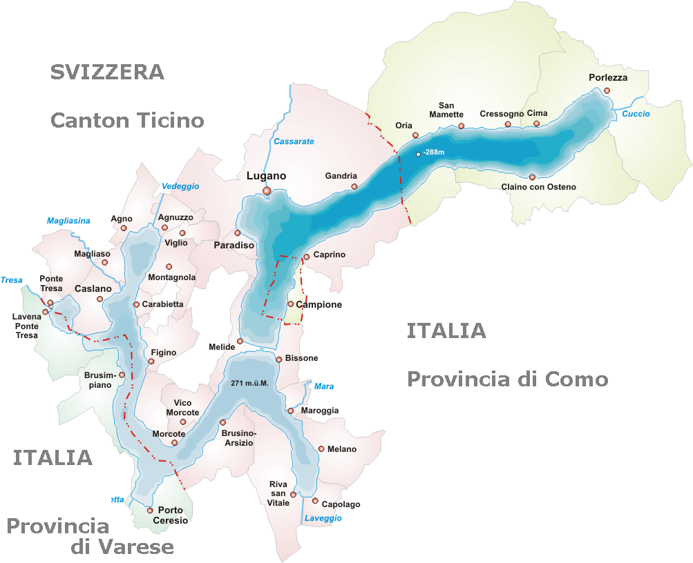
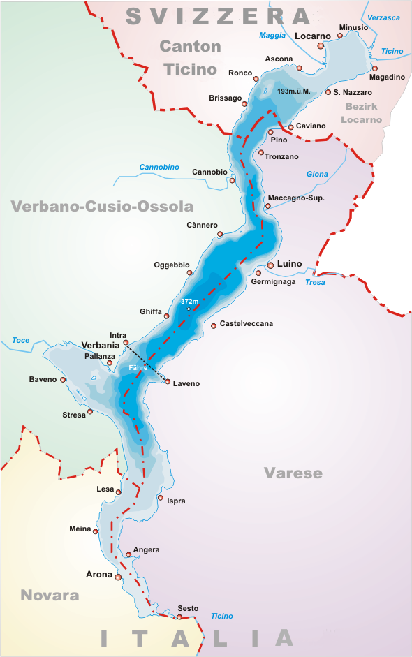
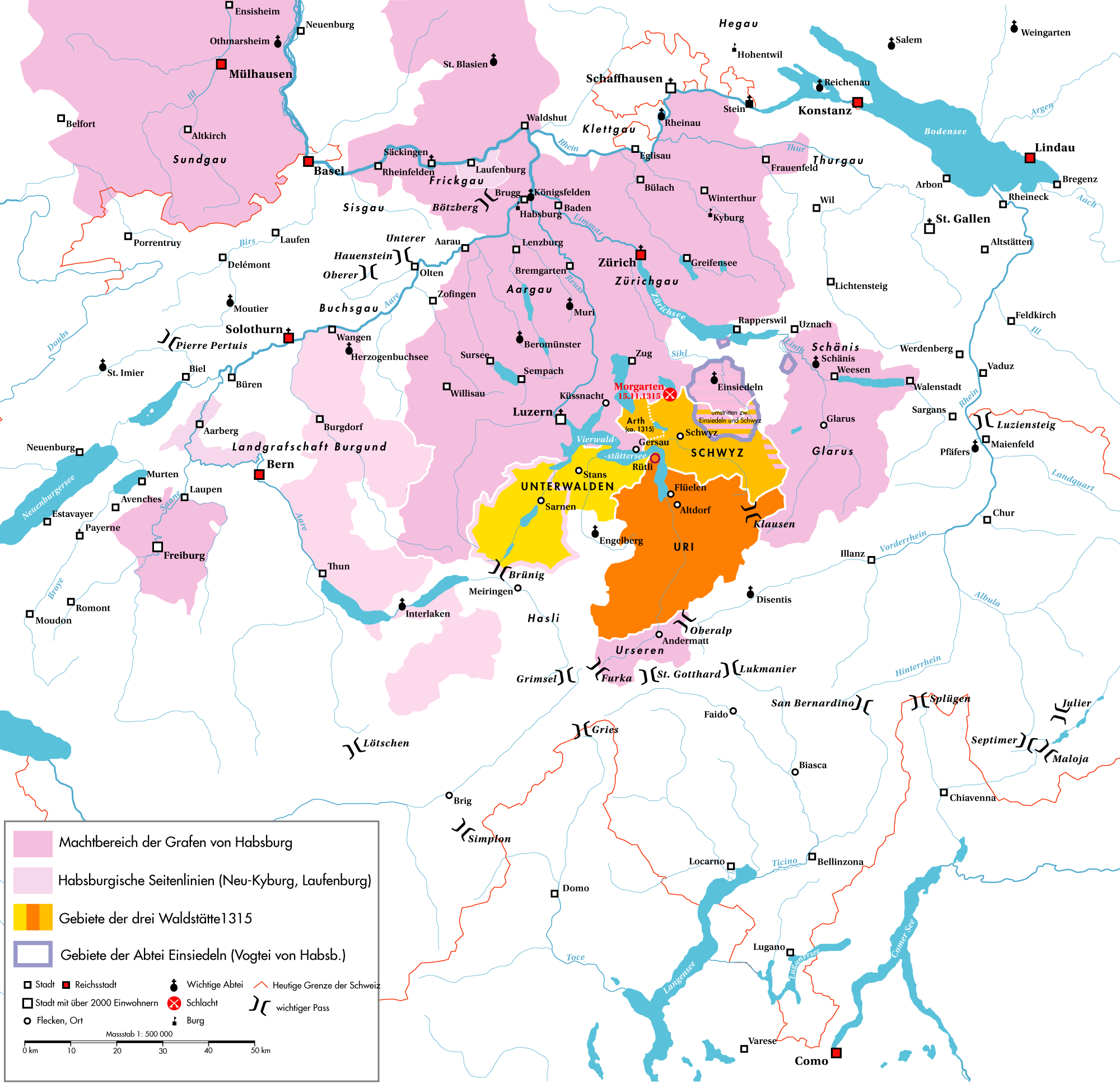
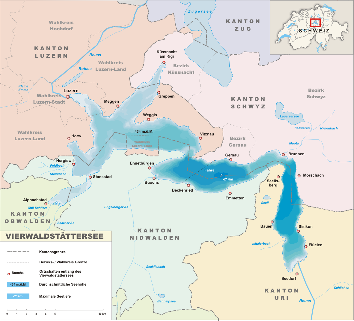
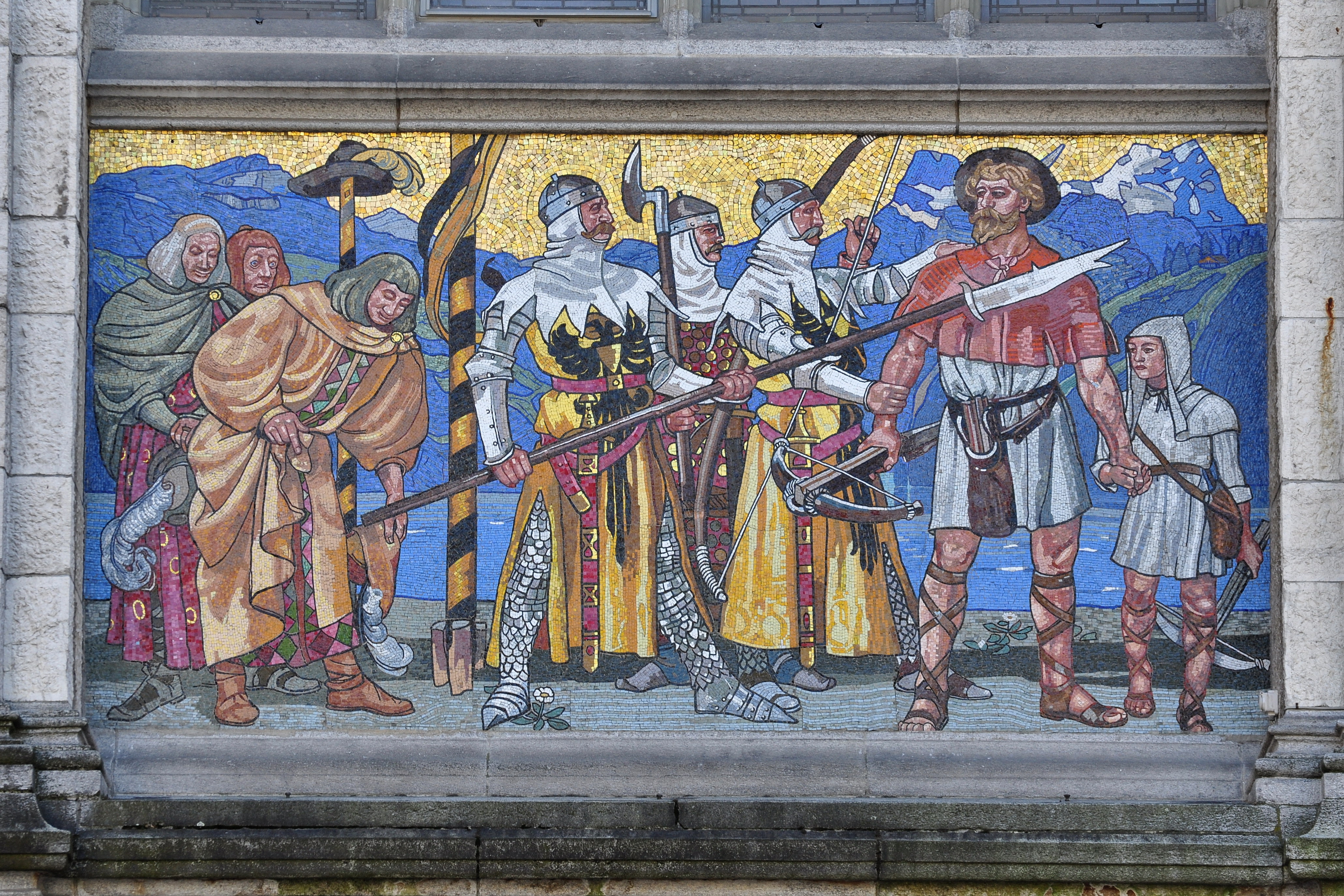
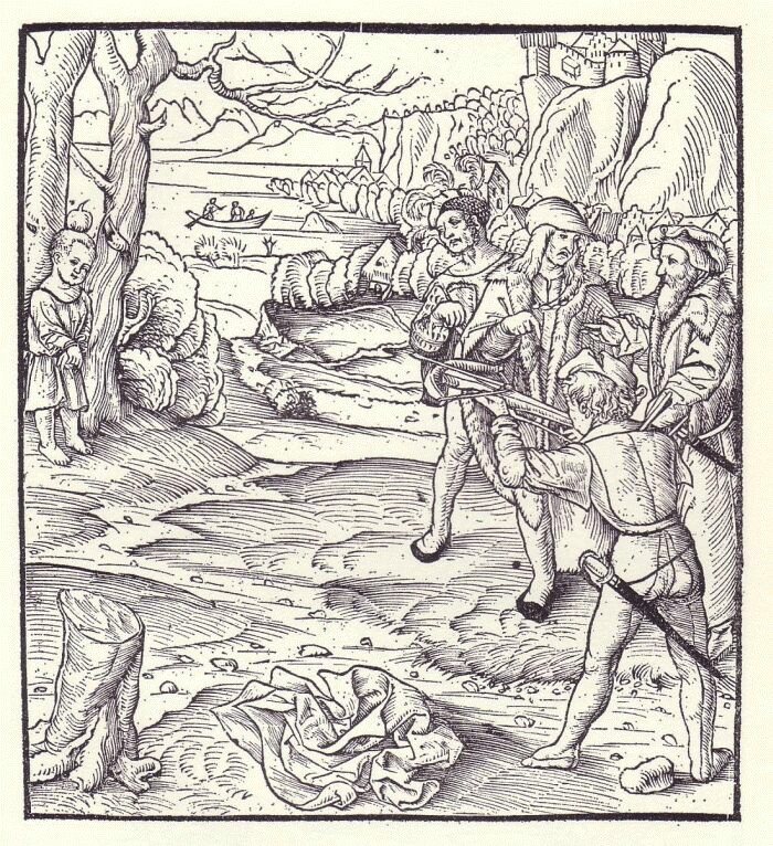
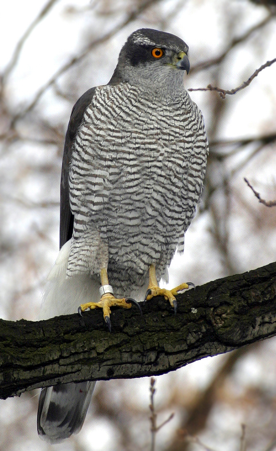
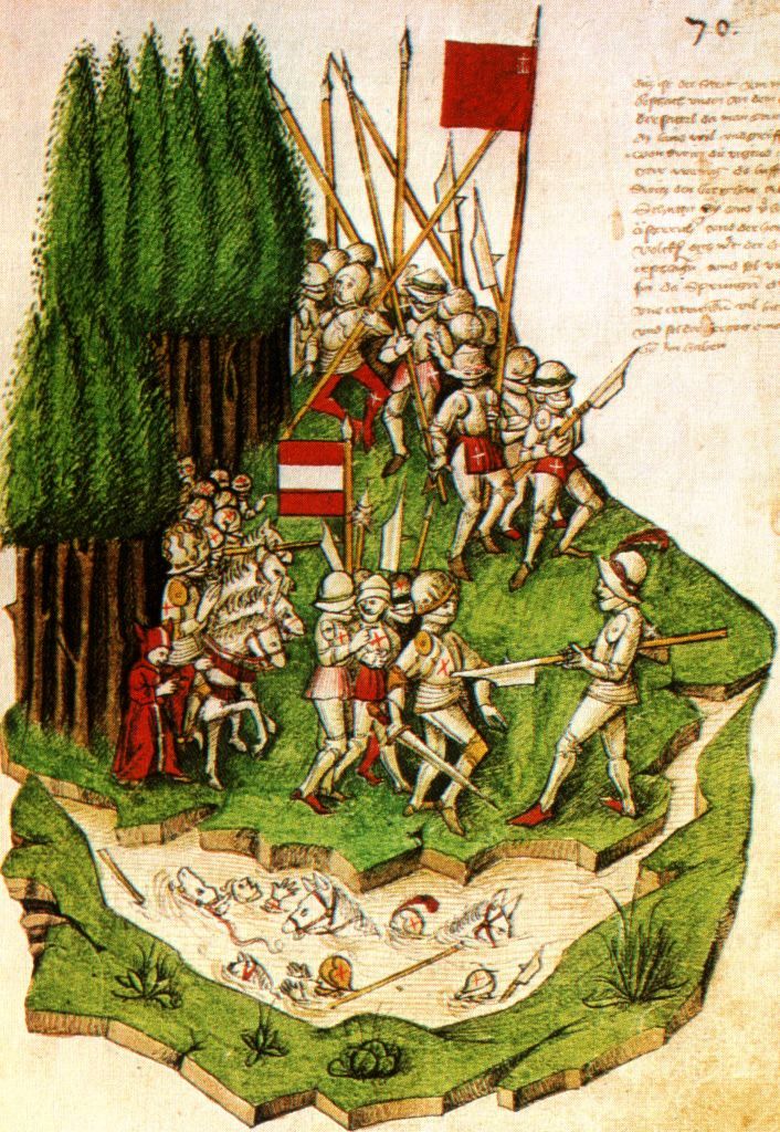
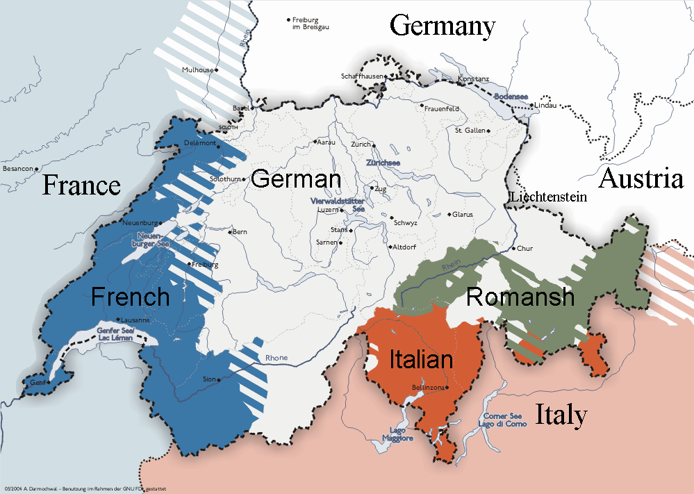
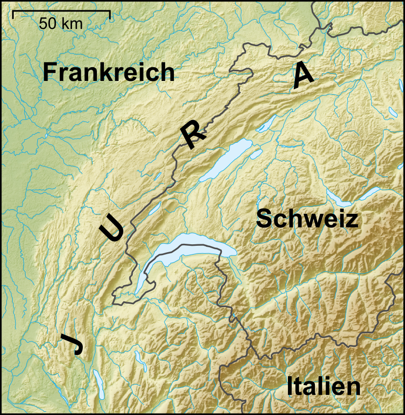
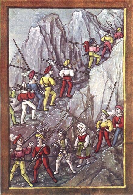
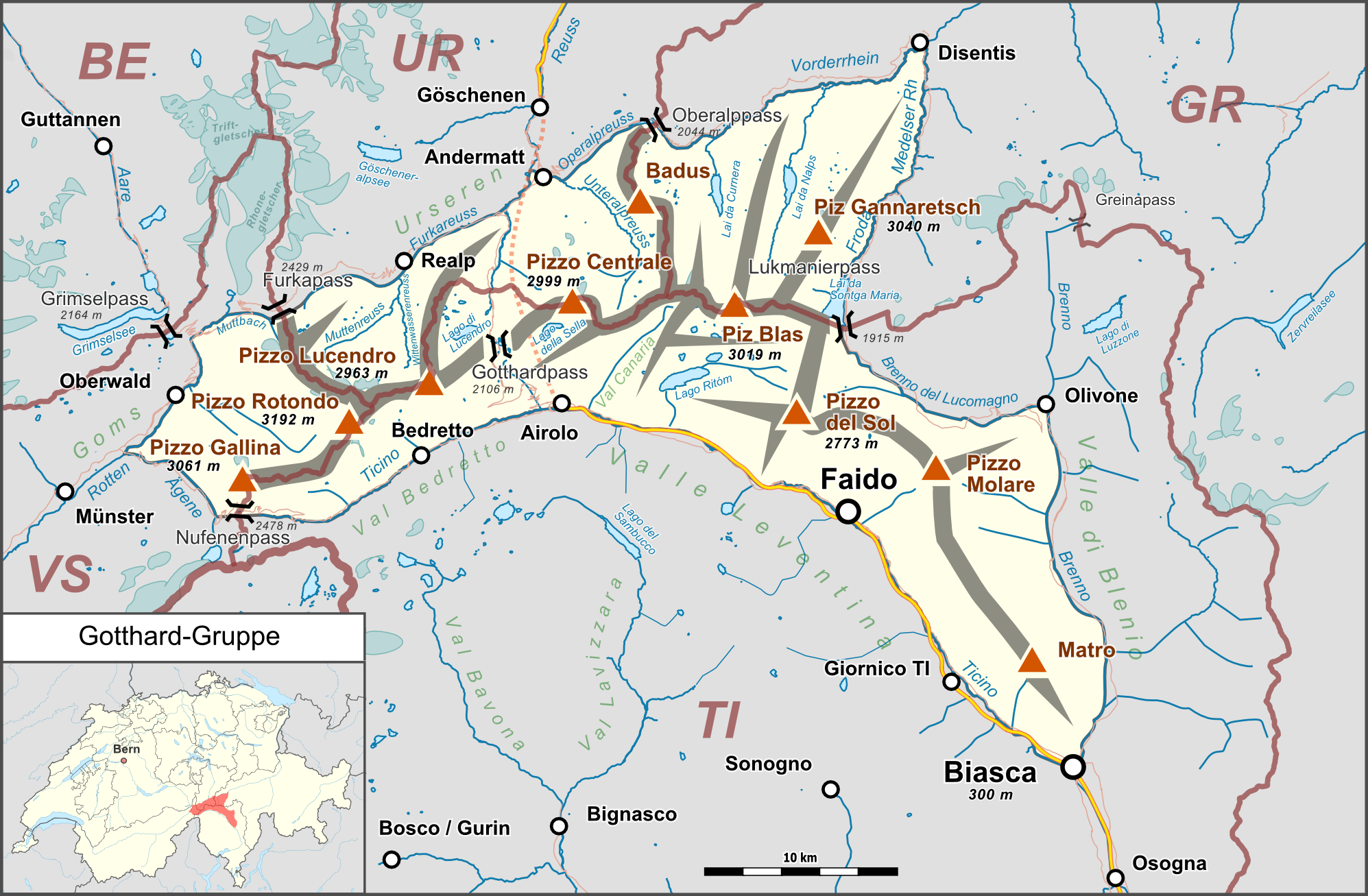
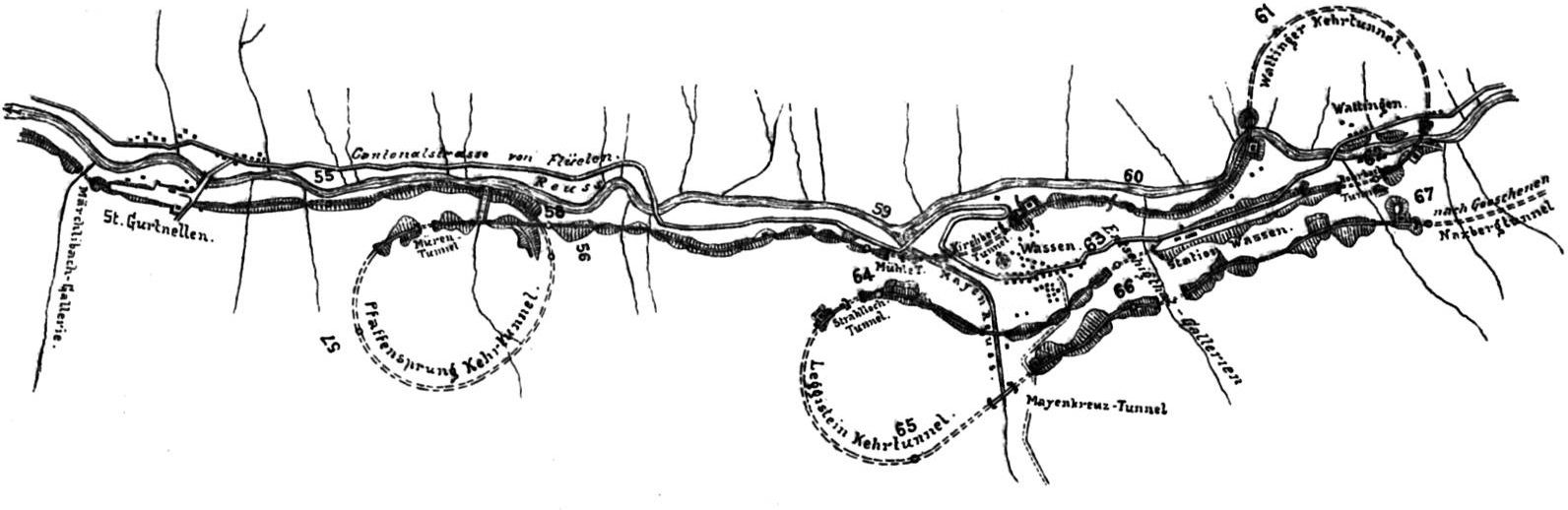
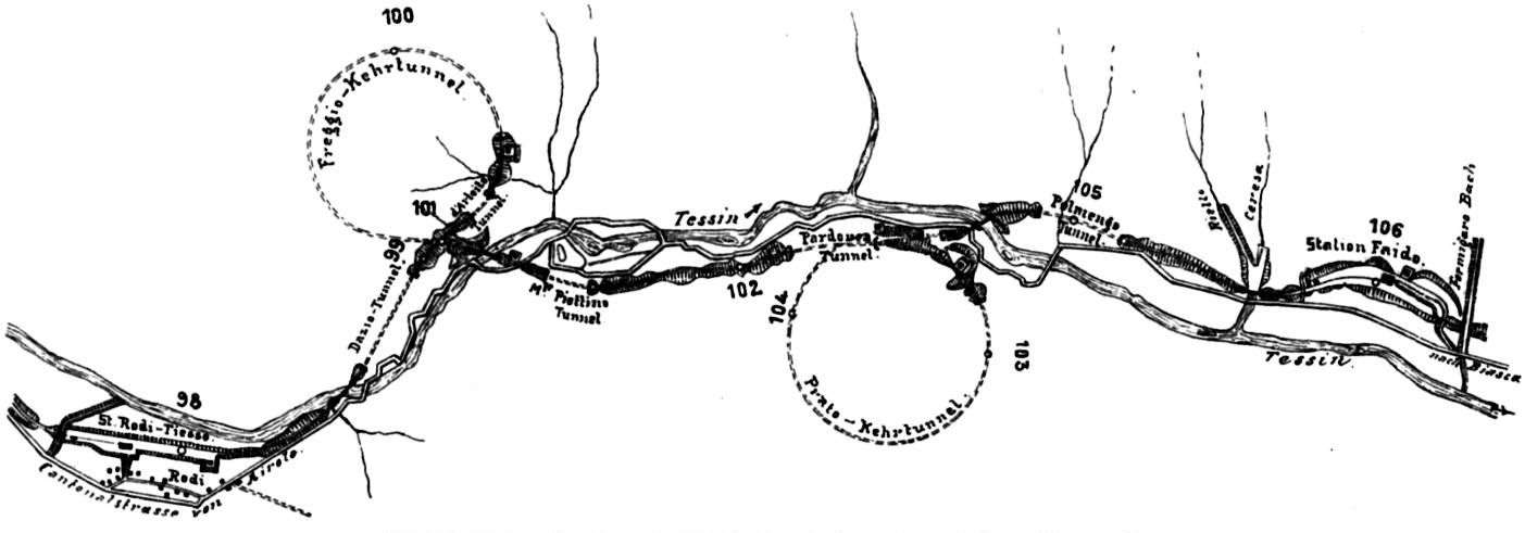
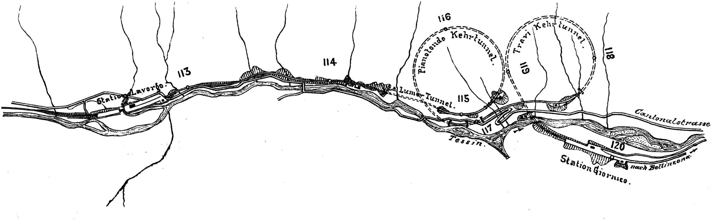
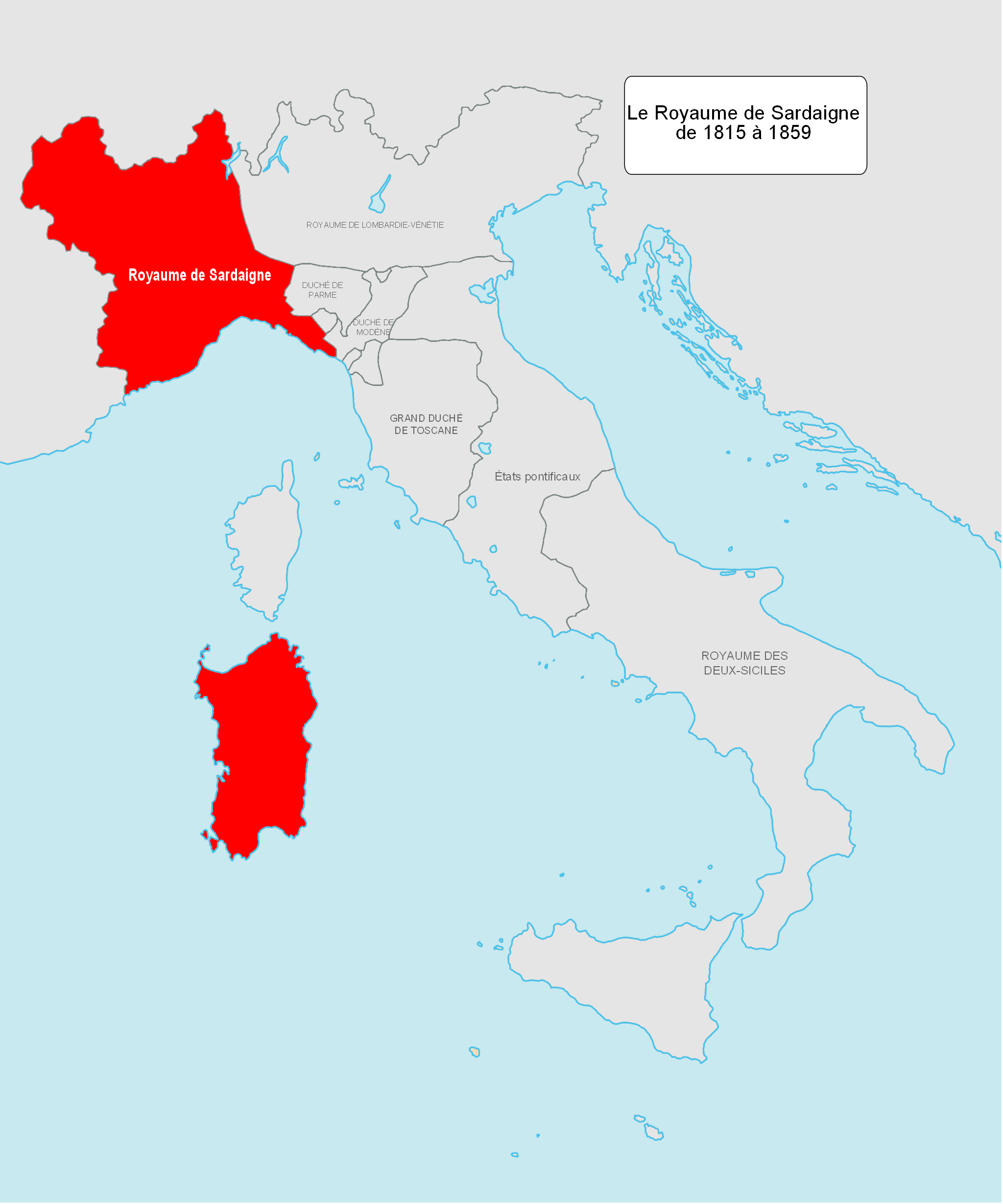
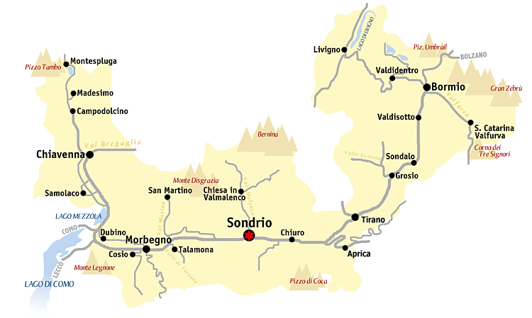
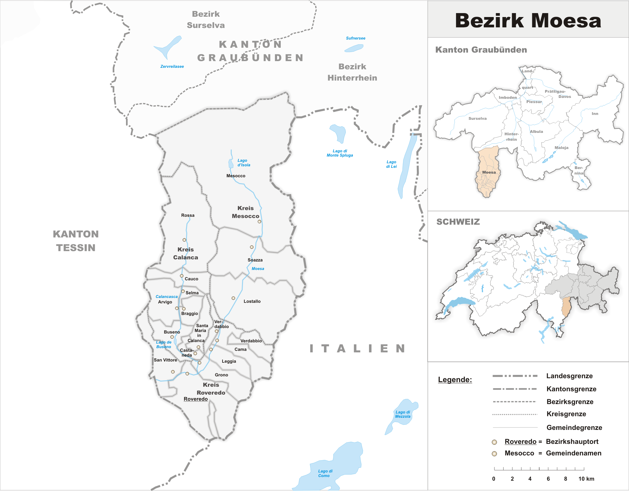
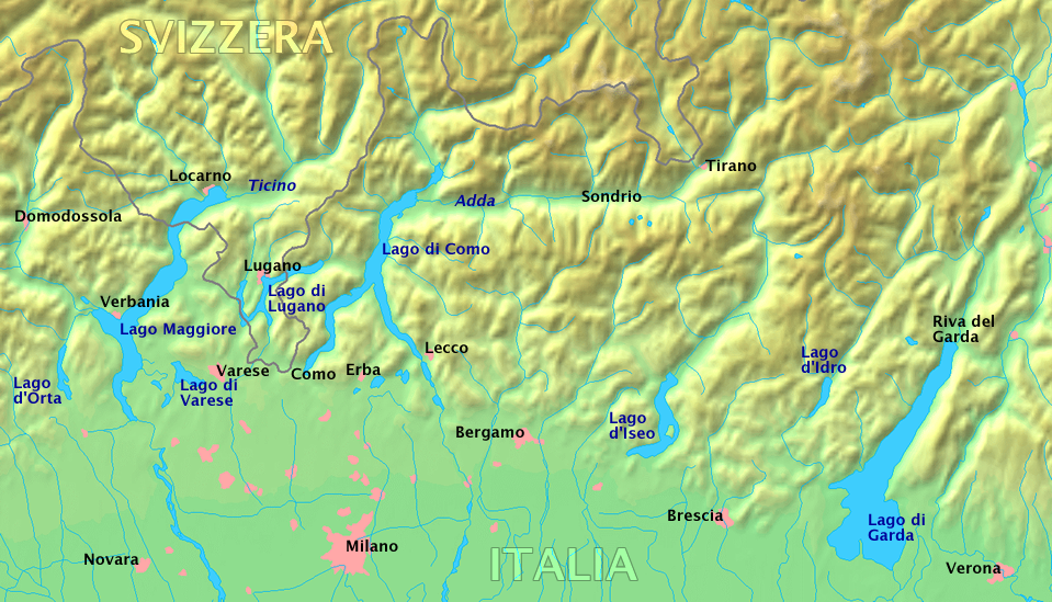
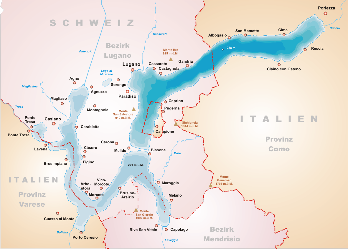
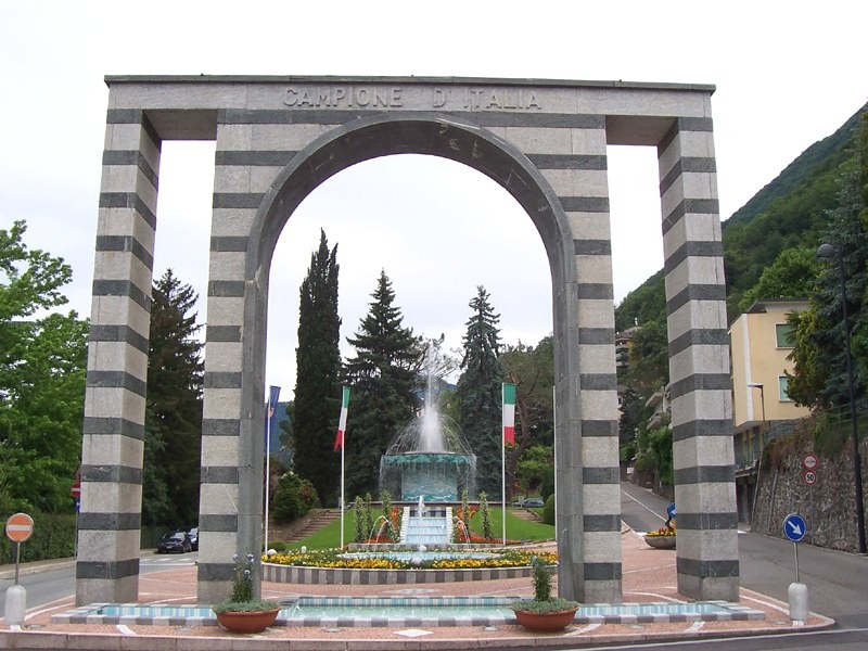