|
Reflections 2009
Series 13
April 29
Polynesian Triangle XIII: Tahiti
| | Dateline Eastbound As I was leaving Auckland airport for Tahiti someone made a meaningful wisecrack about the flight I was about to take. I had a question about a later connection, and the agent told me she couldn’t help me but they might be able to in Papeete. But it was the way she said it: “You’ll have to take care of that when you get to Tahiti---yesterday.” I assume she gets a lot of mileage out of that sort of thing, as she allowed a meaningful pause before the last word. | | | | But it was true. I’d crossed the International Dateline in 2005 on the Siberia trip going from North America to Asia, but that was westward, and I always consider gaining time to be easier than losing time, be it an hour, which is why I prefer to travel westward, or a day. This year I had again crossed it westward from Samoa to New Zealand, gaining time, but this flight from New Zealand to Tahiti would be my first time crossing it eastward, where I would lose a day. For this reason I was glad I’d kept my calendar during the time in Fiji and New Zealand with dual dates on each calendar day, the local one—I mentioned Valentine’s Day--and the time back on my original side of the line.
| | | | Again, picture it this way. It’s 3 PM in NZ. The time zones going east are 4 PM, 5 PM, 6 PM and so on, just as it would be anywhere in the world. The only thing is, we’ve arbitrarily decided to set the borderline between the start and end of days just east of NZ, so while that 3 PM in NZ was counted as the new day, Friday, that 4 PM next door was still the last hurrah of Thursday.
| | | | It actually worked this way. Although there are two hours’ difference between NZ and Tahiti usually, NZ was on Daylight Savings Time during its summer, reducing the difference to only one hour. The flight took five hours, so the difference in time was a total of six hours. We left NZ at 3 PM and got to Tahiti five hours later, plus the hour’s change, at 9 PM. Simple enough, but that 3 PM was the one from Friday, and that 9 PM was still the one from Thursday.
| | | | At least I was back on my regular calendar. But I was also back in the hot and humid tropics. Bummer. On this trip, New York, Los Angeles, and all of New Zealand (barring that one “Sizzler Sunday”) were quite temperate, including returning via LA to New York. The Caribbean, Mexico, the Samoas, Fiji, and now Tahiti were quite tropical.
| | | | I was glad that I’d scheduled this trip on two four-star airlines (2008/8 “Airline Ranking”), Air New Zealand southbound and Air Tahiti Nui northbound (Auckland-Papeete-Los Angeles). The final LA-NY leg was on American Airlines, which is given an “average” three-star ranking, and you could tell the difference, even beyond the dry pretzels AA gave out.
| | | | On ATN, all announcements were first in French, then in English. That is, with the exception of the very first welcoming announcement and the very last parting announcement. Each of these was trilingual, starting with Tahitian. I had to smile. Although there were certainly some passengers on board who understood Tahitian, most did not, yet it was in my mind a very proper assertion of national pride to use a little Tahitian anyway. If someone’s distorted image of Tahiti and the Tahitian language starts with grass skirts on the beach, then they should hear that Tahitian is also quite usable on a modern aircraft, especially a four-star one on an airline with “Tahiti” in its name.
| | | | The service and food were excellent. As is the case today more and more, the flight attendants were at least half male. At first I was a little taken aback to see, while we were still on the ground in Auckland, one attendant with something over his ear, sort of like a cigarette, but sticking out white in front and green in the back. It turned out to be a bud, just starting to open, of a sort of local Tahiti gardenia. But when we got off the plane in Papeete, each passenger was handed one by women in local costume, and just about everyone put it above his or her ear. Frankly, I suspect there’s a system—which ear you wear it over probably says whether you’re single or married—but none of the passengers knew for sure, so they just wore it wherever they wanted to. A week later, flying to LA, each boarding passenger was handed one again, and most wore it throughout the (overnight) flight, but I had to smile when we got to LA and an announcement was made to be sure to discard them, since you can’t bring plant matter into the US. Once again, practicality trumps charm.
| | | | While on the subject of flowers, anyone that was being picked up in Papeete—and, given the late hour of arrival, I’d arranged for a hotel transfer—had a lei hung around their neck. These leis consisted of over a dozen of the same smallish white gardenia, but fully opened, strung together, with a nice scent. I wore mine then, and all the following day on the island tour of Tahiti.
| | | | Before we start in, some comments on place names. The name of the capital of Tahiti confuses some people who are unfamiliar with it because of all its vowels (although it’s not as bad as saying Pago Pago correctly). Papeete is pa.pe.E.te, with each E as in café. I’ve decided to always write it this way. For a long time, I felt inclined to write it Papéété in the French manner, but now I prefer taking a stand in favor of the original Tahitian.
| | | | Speaking of Tahitian and of lots of vowels, the airport serving Papeete is in the next town to the west, and is called Fa’aa International Airport. Actually, sloppy spellers write it Faaa, which REALLY makes it look like something the doctor asks you to say when you open your mouth, but let’s be accurate and maintain the glottal stop. It’s pronounced fa.’A.a, in three syllables. It’s tricky to say the glottal stop before the middle syllable, but not saying one before the last one. Try it.
| | | | I’ll also refer to Wordplay 6 (2006/3), where we included this French question which is almost a tonguetwister if you try to say it fast, since, like Tahitian, it has so many vowels, more than the spelling indicates: As-tu été à Tahiti? [a.tü.e.te.a.ta.i.TI] (Have you been to Tahiti?), which I extended to As-tu été à Papéété à Tahiti? [a.tü.e.te.a.pa.pe.e.te.a.ta.i.TI] (Have you been to Papeete in Tahiti?). I honestly had no concept then, in 2006, that I would now, in 2009, be in the position to answer: Oui.
| | | | Greater Tahiti We have another naming problem. It’s not a misdedication, as with Christchurch and the Avon, it’s more the type of naming problem that Hawai’i had, and resolved. With the Hawaiian islands, the biggest island essentially gave up its name to the group of islands (archipelago), so that it usually has to be referred to now instead as the Big Island. When people today say “Hawai’i” they are more likely referring to the whole archipelago rather than the island that technically has that name. Also, a Mauian has no trouble saying he’s from Hawai’i, even though he’s not from the island technically named Hawai’i. It is not the same with Tahiti. A Bora Boran will only very grudgingly admit to being “from Tahiti”, if at all. The island of Tahiti has not surrendered its name to the archipelago. The question is: Just what is the name of these islands, or better, what should we call them, and how does Tahiti fit in?
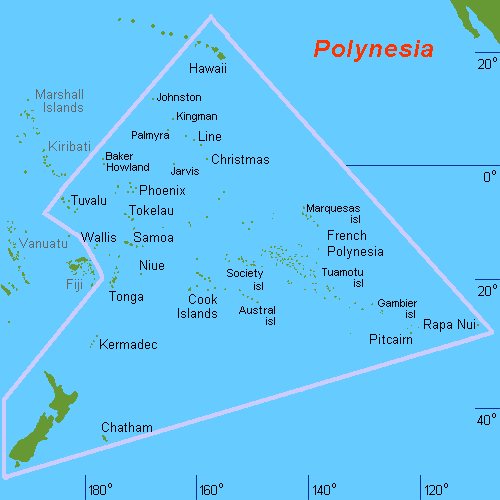
| | | | Now that we’re at the last Pacific area that we’ll be discussing, we can take a look at the entire Polynesian Triangle so that names and locations discussed fall into place: Map of Polynesian Triangle
| | | | You can see Mexico in the upper right to orient yourself, and that the upper part of the Triangle straddles the equator at 0°. Hawai’i is at the top, Autearoa (New Zealand) at the bottom, and Rapa Nui (Easter Island) at the third point. Fiji, related (Melanesian) but not Polynesian, is just outside the triangle. You see Samoa, and we’ve mentioned in passing the Cook Islands and Tonga, near which the Bounty mutiny took place. And you can see, toward Rapa Nui, remote Pitcairn Island, where the mutineers settled. Finally note the distant Marquesas Islands, where Gauguin went after Tahiti, died, and is buried. | | | | But now pay particular attention at the area closest to the Cook Islands, but that extends toward Pitcairn and Rapa Nui. This is La Polynésie française / French Polynesia, where English stops being the overlay language in the Pacific and French takes over (the overlay language in Rapa Nui is Spanish, since it belongs to Chile).
| | | | French Polynesia now covers five archipelagos that used to be administered separately, most with very low populations: the Society Islands, the already mentioned Marquesas, the Australes, the Tuamotus, and the Gambiers, including the vast ocean areas between them. But these last four are of little interest to us, except to comment that the Marquesas have a Spanish name since the Spanish discovered them.
| | | | Well, since we’re not concerned about the other four remote archipelagos, nor are most travelers, the term French Polynesia is useful only in governmental terms, but not very useful to us in travel terms. People rarely talk about traveling to French Polynesia. However, the Travelers Century Club DOES list areas in its tally as based on government, so my trip to “Tahiti” and nearby islands is indeed counted as a trip to “French Polynesia”, which is now my “country” # 121.
| | | | But for travel purposes we narrow it down to the Îles de la Société / Society Islands, which include Tahiti, Bora Bora, and others. Their unusual name is due to Captain Cook. While many believe he named them for the Royal Society of London, who sponsored the first British scientific survey of the islands, which he led, Cook actually wrote in his journal that it was because of their concentration, or, as he put it, “as they lay contiguous to one another.”
| | | | So if people don’t readily refer to going to French Polynesia because it’s too broad a term, and too formal, they also don’t talk about going to the Society Islands, either, which, even though it’s dead-on accurate for the islands in question, is just as formal. They simply talk instead about going to Tahiti, usually implying that there is more than just Tahiti there, but not saying so. Granted, Tahiti is the biggest island, both in the Societies, as well as in all of French Polynesia. I think we can say that common usage is trying to “pull a Hawai’i” on Tahiti and have it extend its name to the group, but that hasn’t happened. And Tahiti itself certainly hasn’t given up its name to the group, even if we call the people on all of these islands Tahitians. My suggestion is to call the group “Greater Tahiti”, but specifying that we want “Greater Tahiti” to refer just to the Societies, and not to all of French Polynesia.
| | | | [Look at what happened to the Sandwich Islands. Just as Captain Cook named the Society Islands during his scientific expedition, so did he name Hawai’i the Sandwich Islands when he discovered them in 1778, in honor of one of his sponsors, the Earl of Sandwich, First Lord of the Admiralty. The name “Sandwich Islands” died out, but “Society Islands” still hovers quietly in the background.]
| | | | There one more subdivision, and it affects how the Society Islands are governed, since they’re in two clusters. The eastern cluster including Tahiti is called the Windward Islands (les îles du Vent, literally “the Islands of the Wind”) and the western cluster including Bora Bora is called the Leeward Islands (les îles Sous-le-Vent, literally “the Islands Under the Wind”). So administratively, the two clusters of the Societies are separate subdivisions within French Polynesia, plus the other island groups.
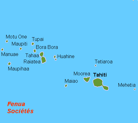
| | | | Let’s now move ahead to talking about Greater Tahiti, divided into the two clusters: Map of Greater Tahiti
| | | | [Note the mixed Tahitian-French caption. I went to a lot of trouble online to finally find out that “fenua” translates as “land, country”. In this case, I’d stretch that to mean “islands”.] | | | | There’s an unusual parallel to Hawai’i here. Remember that the Hawaiian Islands line up, on the map and also in size, NW to SE, with the biggest island in the SE. The acronym KOMBI reminds us of the sequence Kauai-Oahu-Maui-Big Island. Here, too, the islands fall into a similar layout, with the largest island, Tahiti, in the SE. The Societies are also volcanic, caused (just like in Hawai’i) by a hotspot under the oceanic plate. This hotspot formed all the islands in the Society Archipelago.
| | | | But be aware that in the case of Greater Tahiti, we are talking of much tinier islands, some of which are just flyspecks on the map. Here’s a comparison: Oahu is the second-smallest of the Hawaiian islands. Picture an island just 2/3 the size of Oahu, and you have Tahiti—and the other islands are much smaller than that. Here is an overview of the four major islands.
| | | | The island of Tahiti itself has 69% of the population of French Polynesia, or 178,000 people (of which 132,000 are in metropolitan Papeete), yet at its widest it’s only 45 km (28 mi).
| | | | Moving NW, we come to nearby Moorea (mo.o.RE.a, E as in café, but often slurred to just mo.RE.a), the only other Windward Island of importance, primarily because of its beauty.
| | | | Note the separation between the Windwards to the Leewards. If it seems there are a lot of islands in the Leewards, few are of significance. Note Ra’iatea, which is the second-largest in the Societies and the largest in the Leewards. It has historical significance, with a monument second fame in Polynesia only to the statues of Rapa Nui. We will also mention in passing Taha’a, which is almost attached to Ra’iatea, and we’ll refer later to nearby Huahine as well.
| | | | Finally, just beyond, is spectacular Bora Bora, known for its beauty. I’ll explain what makes these islands so attractive, especially Bora Bora and Moorea, which get the most visitors.
| | | | So these are the four most significant islands in Greater Tahiti (the Society Islands), in order from left to right: Bora Bora & Ra’iatea, then Moorea & Tahiti.
| | | | Settlement The Polynesians settled the Marquesas in about 300 CE (AD), and the Societies between 300 and 800 CE. In more recent times, there was periodic activity over the centuries. In 1521 the Portuguese Ferdinand Magellan sighted an island in the Tuamotus. In 1595 two Spanish explorers discovered the Marquesas, hence the Spanish name. In 1616 two Dutch explorers visited a number of the islands, and in 1722 a Dutchman discovered Bora Bora. Finally, Tahiti itself was discovered in 1767 by the Briton Samuel Wallis, followed in 1768 by the Frenchman Bougainville, and in 1769 by the Briton Cook. Cook’s arrival was another scientific expedition, this time to track the planet Venus, and the northernmost point of Tahiti where he did so is to this day called Pointe Vénus. | | | | But the French prevailed, and in 1843 Tahiti became a French protectorate, then in 1880 a French colony. The unit of currency is the French Pacific Franc. When I was there there were 111 to the US dollar. A quick calculation is that they’re close to a penny apiece, so roughly 100 of these francs are about $10. I heard two rumors. They are unfounded, but could have some basis in fact. The Euro, which is used already on a number of French islands, such as Martinique and Guadeloupe in the Caribbean, might be introduced in Tahiti [rumor]. Also, the current Sarkozy government in France is getting tired of supporting French Polynesia, and, even though any independence movement there might not be very strong, might be interested in some sort of a separation [rumor]. In a sense, these two rumors contradict each other.
| | | | Tahiti Having crossed the Dateline from NZ and arriving late in Papeete, I had arranged for that transfer I mentioned to the hotel, where I arrived with that lei of gardenias around my neck. Along with the hotel in Fiji, this was the second and final hotel on this trip which I got free for Starpoints, although there was a very minor hitch. Long after I booked it, Starwood e-mailed me that its Sheraton Tahiti had been sold to “another entity” (which turned out to be Hilton), but that my reservation, free on points, would still be honored. | | | | Refer to this map: Map of Tahiti & Moorea. What you see on this map is, aside from another islet or two, the essence of the Windwards, Tahiti and Moorea. It’s almost three islands, but not quite, since Tahiti has two parts that either never separated (most likely), or that joined.
| | | | We will discuss Moorea in 2009/16, but while this map is available, make a mental note of its shape. It can be said to look heart-shaped, but a heart that has at the top not the usual one, but instead two indentations, since there are two distinctive and important bays cutting into the northern coastline. It also can be described as a flying bird as pictured on a crest, such as an eagle, with two wings spread out, and the head located between the bays. More on all of this later.
| | | | Looking back to Tahiti, note that the larger part, very much circular, is called Tahiti Nui, and we’ve seen the word nui before in Polynesia. This is the area that we said was only 45 km (28 mi) across at its widest. Everyone lives on the coast; the center is mountainous, rising to 2241 m (7352 ft) and virtually uninhabited and reachable only by four-wheel drives. Papeete is located at the NW, and the hotel was on the western edge of town, so the trip from Fa’aa Airport took no time at all. This island is small. The road around Tahiti Nui is about 160 km (100 mi) .
| | | | Do recall that the opposite of “nui” in Hawaiian is “iki”, as in the name of the smaller crater off Kilauea, called Kilauea Iki. I now learn that the K, so common in Hawaiian, appears in Tahitian as T, so the same word is “iti”. Now notice that the beaver-tail-like peninsula in the SE is called Tahiti Iti. It’s more isolated and no road goes all the way around. It’s highest point is only 1332 m (4370 ft). The mountains on both parts of Tahiti are volcanic in origin.
| | | | [You’ll smile at this, but it’s true. If T in Tahitian corresponds to K in Hawaiian, then the Hawaiian name for Tahiti should be—and is—Kahiki. With those K’s, doesn’t it look more Hawaiian?] | | | | I had lengthened my time in NZ to come in on a Thursday night, knowing my ship sailed on Saturday, so I had just Friday to see Tahiti, which was ample. But to be safe, I’d booked a circle-island tour well in advance. Friday morning, though, when the van pulled up, I was surprised to find I was the only client.
| | | | Now I had a private tour around American Samoa, but that was a special trip that I’d arranged specially out of Apia. In Tahiti, where I also had a woman driver-guide, she told me she usually takes a minimum of four, has done the trip before with two, but never had only one before, yet was willing to do it. I’m convinced there are two things at work here. First, the economy has lots of businesses hurting, certainly in the travel sector, but second, I’m betting that it was the pre-booking that did it If I’d tried to arrange the tour at the last minute on arrival, it might not have worked.
| | | | I must say that having a private tour at no extra cost is almost as good as driving yourself. You have no underinterested or underinformed fellow passengers, and you can give your input as to what to add or subtract, if anything.
| | | | We drove counter-clockwise around Tahiti Nui, never straying from the coast road. It was a nice trip of a few hours with stops, but still, Tahiti is no wonderland, and I don’t care what Paul Gauguin and Fletcher Christian might have thought years ago.
| | | | Our first stop was a marae, which I’d been looking forward to seeing. In all of Polynesia there were these cleared sites on which stone platforms were built in ancient times, with raised altars, for religious and social purposes. Most were destroyed with the arrival of the missionaries, and some have been restored in modern times for historical and cultural purposes. By far, the most famous of these Polynesian stone platforms are the ones called ahu in Rapa Nui, which have the huge iconic statues called moai built on them. | | | | But Greater Tahiti does have some restored ones (including the seminal one in Ra’iatea), and we stopped along Tahiti’s west coast at the Arahurahu Marae, which was restored in 1954. The driver dropped me off at the entrance, and I walked into the garden setting, surrounded by woods. Quite frankly, no marae I saw was visually impressive, beyond their garden settings. It is essentially a mass of small black rocks fitted together to form a large rectangular platform, plus a higher altar. But it’s the significant history behind the site that has the significance, and the quiet natural setting did evoke the Tahiti of the past. | | | | There were the odd stops at a park with caves and small waterfalls that I wandered into by myself. She asked me if I wanted to stop at a spring ahead, and I did. It was right at the roadside, and the spring water had been guided to come out of a series of spigots. Locals had come by car, bike, and moped with plastic jugs to fill. I walked up to a spigot and splattered as much water all over myself as I drank, but this stop had a feeling of honest authenticity.
| | | | Just as I’d noticed some reefs in Apia in Samoa, as we went along the Tahitian coast I also had occasional glimpses of a reef. Then, on the south coast of Tahiti Nui, we came to the Gauguin Restaurant, and then the Gauguin Museum.
| | | | When traveling, I regularly do not bother with lunch, as it’s an unwanted interruption in the daily activities, and I can very easily do without it. This is another disadvantage of tours, which, since most people want lunch, force you to make a stop and waste valuable time. But there was an irony here. This tour comes with or without a prepaid lunch, and the version that had been sold me was with lunch. So we stopped at the Gauguin restaurant, which at least did have a nice water and reef view, and I had a very traditional French steak au frites. And I was the only person in the restaurant, or at least until three ladies arrived as I was leaving.
| | | | Now the Musée Gauguin is supposed to be the highlight of one’s visit to Tahiti, but I was prepared to take that with a grain of salt, and I was quite right. I think I can make a generalization based on two museum visits: one should never expect too much from museums in the third-world tropics. I saw that first when I stopped at the Fiji National Museum in Suva. There were some nice wooden canoes, and the display on Indians arriving in Fiji was informative, but it was a ricky-tick building and really didn’t offer that much. That was the place where the burned rudder of the Bounty was just lying around on the floor during a renovation.
| | | | The Musée Gauguin was very much in that vein. Again, I was the only one in the entire museum while I was there. The driver waited at the entrance, and gave me a voucher to cover the entrance fee (!!). The entire museum consisted of four buildings around a grassy courtyard. I do NOT think they were built of plywood, but that’s the ricky-tick mental image one got. Do not think for a moment that there are any Gauguin paintings in the museum, given the tropical climate, the dumpiness of the buildings, and the high value of such paintings. There were a few reproductions, and a few displays on his life. Frankly, the only thing of interest was the fact that this was located in the region where he lived between 1891 and 1893, plus one large display showed post-card sized images of his paintings, and indicated which museums or private collections around the world housed them.
| | | | After the museum, we drove across the narrow isthmus that forms the connection over to Tahiti Iti. The views here of the peninsula were to me far more interesting that most of what I’d been seeing, and, riding up the east coast, the views back of the mountains of Tahiti Iti were impressive. The seas on this side of the island were considerably rougher. We stopped at a blowhole on the side of the road, where, each time the waves came crashing into the coast below, a spray would work its way up through the rock so that, a few seconds later, a big spray of water that looked like steam would puff out of the hole. Then, as we rounded the north part of the island, the waves were highly conducive to surfing, and I asked her to pull over so we could watch some of the surfers. It was also on the northern tip of Oahu that I’d watched the surfers last November at Sunset Beach. | | | | If you look at the map, you’ll see the point sticking up at the northern end of the island. This is Pointe Vénus, where Cook conducted his astronomical experiments in 1769, and where the Stevenson lighthouse of 1867 stands. Unusually for a lighthouse, it’s a square tower.
| | | | As we arrived at the east side of metropolitan Papeete, the driver made a historical ethnic point of interest. In 1868, Chinese workers were brought over to Tahiti to work in the sugar cane fields. Today they form 12% of the population—but they own 65% of the businesses. The parallel with the Indians in Fiji struck me immediately, where the situation is more extreme, since today Indians are closer to half of the population of Fiji.
| | | | Papeete was not part of the tour, and it was only mid-afternoon. She wondered if I wanted to be dropped off in town for the afternoon. That’s exactly what I was going to suggest, since I could walk back to the hotel afterward. That’s the advantage of having a well-placed hotel, and not one down the coast somewhere.
| | | | Papeete is pleasant enough. It has a tree-lined ocean promenade, right off of which in the very center of town the ferry to Moorea left, and right next to that, was the cruise ship docking area, which I needed for the next afternoon. This harbor area was very pleasant, and didn’t look industrial at all.
| | | | The center is not large—just a few blocks this way and that. I went through the commercial district, which looked authentic, for locals, with no tourist junk in sight. This was equally true for the covered marketplace, where it’s always a pleasure to look at the fruits and vegetables (also meat and fish). The city hall had been modeled after a local royal palace. There was a cathedral, and the French Polynesia Assembly. Nearby was a spring which gave the city its name, and a park with a stream flowing through. Black pearls are a Tahitian specialty, and closer to the western side of town on my way back to the hotel was a black pearl museum, but also had a sales area, which you can be just as cynical about as I am. It was still quite a hike to the hotel, but at least I had my exercise for the day.
| | | | That evening, my hotel balcony was close enough to town so I could watch the MS Paul Gauguin sailing into the harbor, which I would board the next afternoon. I also watched the sunset, and later saw the Southern Cross in the nighttime sky.
| | | | This sounds like a paradox, but the nicest thing about Tahiti is Moorea. You have to check the map to see what I mean. I’ll talk about my visit to Moorea later, but since it’s so meaningful to Tahiti, I’ll say this much now. Moorea is only 17 km (9 mi) northwest of Tahiti, and is easily visible. People stay on the northwest side of Tahiti, where my hotel was, and go to well-situated restaurants there, just to see the view of the jagged peaks of the dreamy island. Take a look: Sunrise over Moorea | | | | Although my hotel had the nice view, and I could see it from my balcony, the weather didn’t cooperate, and there were some clouds on the horizon for my sunset view; morning views were the same. But visitors to Tahiti just stare and stare at Moorea.
| | | | Two other comments about this picture: I think the reef around Tahiti is barely visible if you look hard. You might be able to see the waves breaking over it. Also note the overwater bungalows bristling out from a pier. This type of unit was first built in Bora Bora, where my sister Pat stayed in one some years ago, and where they’re quite common now, and have now spread to Tahiti. Pat pointed out that there are glass floors where you can watch the aquatic life below you. | | | |
| |
|
|
|

