|
Reflections 2009
Series 16
April 29
Polynesian Triangle XVI: Bora Bora - Copter & Sub - Moorea
| | Bora Bora Going from Ra’iatea to Bora Bora, in that order, follows Polynesian traditional logic inasmuch as Ra’iatea was considered the birthplace of the world, and tradition also held that nearby Bora Bora was the next island created. For that reason it was named Pora Pora, which means “First Born”. I assume the reduplication in the name emphasizes that fact, so it’s something like “very first born”. But you will notice a minor variation. Westerners misheard Pora Pora as Bora Bora, so, even though Tahitian doesn’t actually have a B sound, Bora Bora it remains.
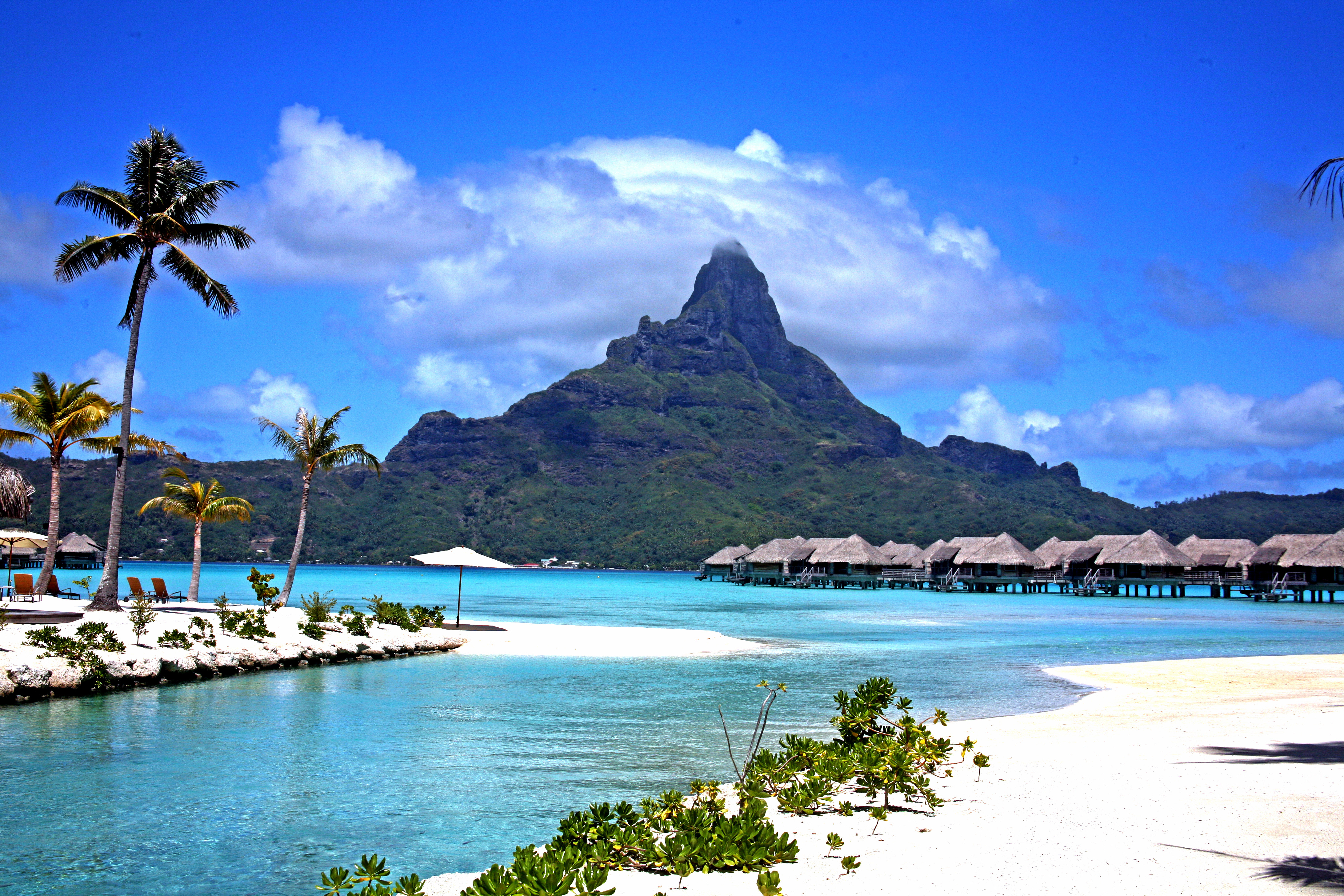
| | | | Beaches and palm trees are in lots of places, but you will understand visitors’ claims of the beauty of Bora Bora if you understand the geographic layout of high island, coral reef, motu, lagoon, and pass. This space view should help: Bora Bora from Space
| | | | The view is turned around. Find the pass, and remember that that faces west, so north is to the lower left. Ra’iatea is off the picture in the upper left, and we had sailed around the north side of Bora Bora, turned, and entered the lagoon via the (artificial) pass. We were at anchor for two days between the pass and the main town, which is just opposite the pass on the main island, and can be discerned on the picture. In my opinion, this location has the best views, in every direction.
| | | | In my estimation, the other factor lending to the charm of Bora Bora is its petiteness. It’s like a little toy. The greatest extent N-S of everything including the reef is a mere 8 km (5 mi) and E-W 5 km (3 mi). The population is only 8,900, and, like in Tahiti, inhabits primarily the coastal strip of the main island, whose circular coast road I understand is only 32 km (19 mi) long.
| | | | You can see the large width of the reef as it underlies part of the lagoon, and also the fact that some large, rather continuous motus dominate the east and north sides, but aren’t as evident elsewhere. My guess is that motu location is based on ocean currents.
| | | | At the extreme NW (lower left) is Motu Mute, the site of Bora Bora airport, whose landing strip you can see on the picture (although I didn’t while I was there). We may be used to arriving at an airport and then taking a limo or bus, but anyone landing here, since they are on a motu, has to transfer by launch across the lagoon, although most hotels send their own launch for their clients. This airport is another bit of heritage from WWII along with the artificial pass through the reef. The US fortified Bora Bora, and they say some other military installations remain, but the island saw no combat. The airport was built in 1943, and became a commercial airport in 1958. It remained French Polynesia’s only international airport until Faa’a Airport was finally built near Papeete in 1962. So you see, we don’t only discuss ancient Polynesian history, but also 20C events.
| | | | I’ve left the best for last: the high island. This is geographically more interesting than Ra’iatea, because while Ra’iatea is also volcanic in origin, Bora Bora is the highly eroded remnant of a caldera of an extinct volcano. Once you know this, you can see it on the space view. The island is slightly C-shaped, since it’s the surviving eastern half of the caldera wall. It’s mountainous, since the wall is eroded into sharp peaks, the highest being distinctive Mount Otemanu at 725 m (2379 ft). An additional oddity is the fact that there is a separated, much smaller fragment of the southwestern part of the crater wall sitting by itself in the lagoon. This part is low enough so that it can easily be mistaken for a motu. As a matter of fact, it’s actually called Motu Toopua, but that’s a misnomer, as you can see, since it doesn’t sit on top of the reef.
| | | | Here’s a view from closer to sea level: Bora Bora from Eye Level. With Mount Otemanu in the background, it shows again the over-water bungalows of the type that my sister Pat stayed in some time back, which include a partial glass floor for lagoon viewing. The bungalows were originated in Bora Bora three decades ago and are now quite standard there (we also had a picture of them in Tahiti), as many hotels have them. They stand on stilts and bristle out from a long pier.
| | | | Copter & Sub We had two days in Bora Bora and the first day was my up-and-down day, since I went up in the sky in the morning in a helicopter and went down under water in the afternoon in a “submarine”. I’m glad I scheduled them both in the same day, just for the up-and-down uniqueness of it.
| | | | THE COPTER At the appointed time for my group, we took the tender to town and were directed there to a little storefront. I had flown in a helicopter four times in 2008, my first such flights ever. Perhaps remembering the sleek, modern craft those times, and being handled by several people in the crew spoiled me. At Victoria Falls and on the three islands in Hawai’i, the choppers were shiny new models, and there were two or more available in each location; one worker would drive you to the helicopter section of the local airport, another would weigh you in; at your scheduled time another would walk you onto the field giving numerous instructions such as watching your head when near the rotors. This person would also tell you just where to sit, either up front next to the pilot or in the back, and if so, where in the back, just for the best balance. As I say, I was spoiled by such spit-and-polish professionalism.
| | | | I suspect the helicopter service on Bora Bora had been transferred from Gilligan’s Island. I will hereby admit that I’m laying it on thick, for effect, but I will also say that there was considerable eye-rolling among the passengers before we took off.
| | | | There was a person sitting behind a desk in the tiny storefront. And that was it, since he turned out to be the pilot. On the plus side, he looked like he was involved in the French military, wearing a spiffy white shirt and trousers, with some gold insignia on the shoulders. I do think I recall being properly weighed in, which is a positive note. We then jumped into a van, and the office manager-cum-pilot turned out to be our van driver as well.
| | | | If the island is tiny, the town is tinier, and we were at the “field” in about three minutes. Knowing that the airport is out on a motu, I suppose we shouldn’t have expected to go there for a quick helicopter flight. But the “field” we were driven to looked like someone’s large back yard. It had a chain-link fence around it and a helicopter landing pad. Just one, since that’s all there was room for. It’s just as well, since there was just one helicopter, anyway, sitting quietly by itself on the pad.
| | | | I say “quietly”, because, while I was used to having someone bring us up to a pad where the pilot had the rotors running already, but since the pilot was also our van driver ….
| | | | He spoke French, and apparently no English, so there was no spoken commentary, even though I said a few things in French to him. Apparently they don’t do commentary on Gilligan’s Island. He indicated that we should get in. When we asked where, since other passengers were also used to the standard helicopter protocol, he indicated just anywhere. So the four of us seated ourselves, like getting onto a bus.
| | | | The bus metaphor is apt. I will admit to only some exaggeration when I say this, but you should picture a Volkswagen bus from a past decade that had done cross-country service, and you’ll more easily be able to visualize this chopper. The image that sticks in my mind as I scrambled in the back, seating myself in the middle, was that the corner of the upholstery in the seat was totally worn away exhibiting a generous amount of dried-out foam rubber. At this point you hope they maintained the mechanics of the craft better than the interior décor. | | | | When I said the pilot was the only employee, I lied. There was one other. Once we were in and closed the doors (yes, they did close), a guy in coveralls that looked like a school janitor appeared from somewhere, pushing a small dolly. I got a quick look, and it seemed like on the dolly was a car battery attached to jumper cables. He hooked them up to something on the side of the chopper, the pilot did his thing, and you could hear the loud sound of the rotors starting up. One of the passengers said something about that’s the way it’s usually done, and I chose for my own mental well-being to believe him. We’d already put our standard headphones on, so you almost couldn’t hear anyone speak that didn’t have a mike, but of course, there weren’t any announcements, so the headphones just served as noise protectors. We were ready to go.
| | | | We were south of town, right on the edge of the lagoon. We rose, and, instead of giving the passengers a moment to get acclimated to flying and to moving from land to over water, Cowboy Joe immediately tilted us forward at a steep angle and we zoomed out over the lagoon, to a sucking in of everyone’s breath.
| | | | Bora Bora being so tiny, it was only going to be a fifteen-minute ride, which we knew in advance. For most of the time, he maintained rather a low altitude. We first circled the lagoon, swinging north above the town, then we were above the ship. The altitude we maintained was about triple the height of the ship, so you could see everything quite clearly below. We turned south around the far side of the lagoon over the pass, motus, and some of the overwater bungalows. It was quite a nice ride.
| | | | In no time we were above the south end of the island, where there are many hotels, and more overwater bungalows, probably since the beach area is more extensive here. We then continued up the east side of Bora Bora heading north, now essentially behind the C-shape of the mountains that form the remnant of the crater wall. This was the calm part of the trip with Cowboy Joe. At this point one would be lulled into complacency, expecting to continue beside the mountain along the motu and reef to the north side of the island, and then swing back to the starting point. But that never happened.
| | | | I will direct the worthy reader’s memory to the famous scene in the 1969 film “Butch Cassidy and the Sundance Kid”, where both of them are being pursued by enemies, and they come to a cliff with a river below. Not having any choice, they jump off the cliff, shouting a lengthy “Oh, shi-i-i-it!!!” Well, I had my own such moment in Bora Bora in which that phrase came in very handy.
| | | | Picture this: to the right of you, motu and reef; to the left, the sheer wall of the mountains, going up and up; straight ahead, salvation around the north side of the island. But ‘twas not to be.
| | | | All of a sudden, with no warning, Cowboy Joe turned the copter sharply to the left, heading right for the almost vertical wall of the mountain. You knew he wasn’t really headed there, but did figure out what his plans were, and all of a sudden we started shooting upward, upward, upward, like an elevator on a spree. This is when I had my own “Oh, shi-i-i-it!!” moment, which is what I shouted out loud into the din of the rotors as we shot skyward. For Cassidy and Sundance it was a downward plunge, for me an upward shoot.
| | | | It wasn’t the sudden increase in height that was disconcerting, it was the knowledge that tops of mountains might have severe winds and certainly will have updrafts (remember the Staubbachfall in Switzerland [2008/15]), and here we were in a Gilligan’s Island helicopter. As our elevator approached the top floor, sure enough, we hit an updraft, and the crate shook: KA-BOOM!, KA-BOOM!, KA-BOOM!
| | | | We said earlier that Mount Otemanu was 725 m (2379 ft). Going over the ridge, we went right past it, with plenty of clearance. I will estimate that we had gone from a rather low level to about 700 meters (2300 feet), and were about to go down again.
| | | | I will give Cowboy Joe the benefit of the doubt, in retrospect. It is probable that he had gradually been increasing our altitude without our noticing as we rounded the island so that we might have been rather high already, but flying above the ship and town is what stays clearest in my mind as to the low altitude we had been maintaining. OK, I suppose he knew what he was doing.
| | | | As we went over the ridge I think the view was gorgeous. I can’t be totally sure, since we saw it for only about 1/100 of a second. They say that when you go through the eye of a hurricane, there is violence, then calm, then violence again. That’s what we experienced. After the shaking, while we were above the ridge for 2-3 seconds, all was calm. And then, on the other side, we hit the other updraft and: KA-BOOM!, KA-BOOM!, KA-BOOM! And then we descended, like in an elevator, down to the lagoon level. We overflew it a bit, landed, and then Cowboy Joe drove us back to the office to get the tender, where he resumed his position behind his desk, waiting for the next victims, er, passengers. (I’m kidding. It was really a memorable experience.)
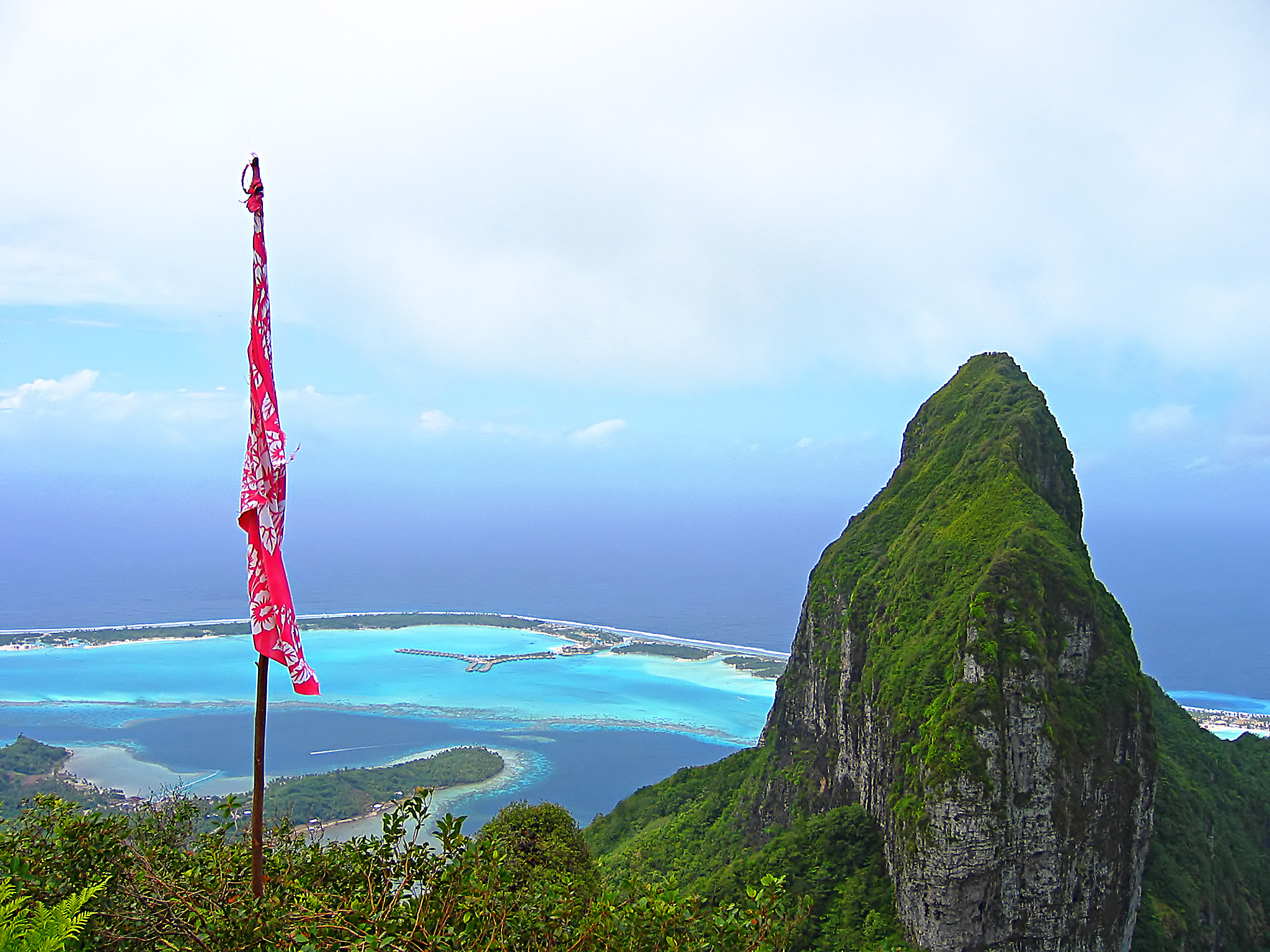
| | | | Believe it or not, I’ve found a picture where you can see the high point of this flight: Bora Bora from the Mountains. This is a “backwards” view, since it faces the northeast of the island, the part with a lot of motus, which you can see, along with more bungalows. The town, the ship, and the main part of the lagoon would be behind us in this view. You also can’t miss distinctive Mount Otemanu. I presume the flag belongs to a climber of some sort. In any case, visualize our copter rising from far below in the background and coming towards the viewer at this point like something out of Star Wars, and then hold your breath.
| | | | THE SUB In the second half of my up-and-down day, I took the tender from the ship back to town at the prescribed time for our group, and then stepped into a launch to take us to the “submarine”. There were six of us, two couples, another gentleman and myself. We zipped across the lagoon and out the pass just a small way into the open ocean to a floating dock in the open sea. As we approached, we could see the color of the sub. Any guesses?
| | | | The sub was bright yellow, sticking to the image of the Yellow Submarine. It was waiting on the other side of the dock from where the launch tied up. If you’re picturing a huge cigar-shaped submarine, or have images in mind from the film “Das Boot”, that’s not what it was. Above water was a rectangular support facility which included the entrance hatch. While we were still seated in the launch, the pilot explained how things would work. The launch operator would stay above operating the support facility. We would go down one at a time through the hatch, and be seated in the circular area, and he would follow us down, secure the hatch, and get us started.
| | | | I have to try and decide what to call what we were in, since they had used the word “submarine” so potential visitors would know it was an underwater visit. But submarines are full-sized self-propelled ships that are not dependent on a support facility. I find that a “submersible” is small, has limited range, and is not autonomous, being connected to a support facility on the surface to charge its batteries and to replenish high pressure air or oxygen. A submersible also has greater mobility than the typical submarine.
| | | | I also note that a bathysphere was a spherical submersible that was unpowered and lowered on a cable, with a rubber hose that carried an electrical supply and phone wires. But that seems to be a historical vessel, which was the precursor to the more modern bathyscaphe, which is a self-propelled submersible. Although the vessel we were in down below the support facility was round, a bathysphere is too old a term, and I don’t think we were in something as complex as a bathyscaphe, so I’ll keep it safe and stick to the more generic term: we were in a submersible. We were small, with a very limited range. We were tethered to the support facility for air, power, and phones. We could and did turn left and right, so I suspect there was some self-propulsion, but I’ll just have to guess that we were lowered and raised on a cable from up above. We were not so autonomous to be able to do it ourselves. | | | | The room was small. Three sides of it had very large round windows, with two seats in front of each. The captain sat against the back side, directly under the hatch. There was a bit of room in the middle so you could step across to see things on the other side. The pilot kept monitoring the air and the rate of ascent and descent periodically during the half hour we were below and was talking with the assistant up above in between his comments on what we were seeing.
| | | | Well, we saw fish. They looked particularly large and close, since everything in the curved windows was distorted in size. I made notes that we saw butterflyfish, sharks, barracuda, and red snapper, and certainly a lot more. This is what the scuba divers come down to see. I am not interested in scuba diving, since I will see all my fish behind glass in an aquarium, thank you, or, quite frankly, behind glass in the submersible—it was very similar. (I also don’t enter tiger cages at the zoo, but watch them from behind the fence). More interesting to me than just seeing thirty minutes’ worth of fish swimming was to experience the coral reef from down below. We descended alongside it, and I could see it out the opposite window over on the right.
| | | | But the most enjoyment for me was going down into the depths, followed by actually seeing the reef and the fish in situ at those depths. We had a sensation of movement only when we turned left or right to see fish or the reef better. I was surprised that there was absolutely no sensation of descending or ascending. Perhaps, in retrospect, it was because we were moving up and down on a cable, but even in an elevator, you can often feel movement. So I got my fun from just looking at the depth gauge, which was easily visible. We went down to 10 meters, then 20 meters. I was hoping we’d pass another round number, and we finally passed 30 meters, then reached our maximum depth of 33 meters (108 ft). I had read that the maximum we could expect was 120 ft, or about 36.6 m, so I was quite satisfied.
| | | | [Watching the depth gauge brought me back to the Explorer II in Antarctica, where I desperately wanted to reach the latitude of 65°S, and was standing next to the navigator on the bridge as the instruments inched toward my goal, ending at my southernmost point at 65°04’S (2006/15 Day 13).]
| | | | I was curious what an average diving depth would be for most scuba divers, and how our depth compared. Although scuba divers have gone down to record depths, I now read that the informal but accepted maximum depth that most scuba diving certification agencies recommend is 30-40 m (100-130 ft), so our submersible attained a depth equivalent to the maximum range that most casual scuba divers would probably attempt to reach. | | | | On to Moorea The second day in Bora Bora I used just for relaxing on board, and late in the afternoon we sailed for Moorea. As I said earlier, the arrival in, and then the departure from, Bora Bora, although both took place late afternoon, were the two daylight sailings that made the cruise really seem like a cruise. And the departure had one happy twist. | | | | We had just seen the film “The Bounty” on board, where, toward the end, a crew member calls out to Fletcher Christian that he finally sees land, and right in the middle of the reddish horizon you see a tiny, flat-topped island, which they identify as their goal, Pitcairn Island.
| | | | As we swung out of Bora Bora’s pass facing west, and about to turn left, someone from the ship in the know pointed out to me, straight ahead, right in the middle of the reddish horizon, a tiny, flat-topped island. This local island just west of Bora Bora was used by the filmmakers to play the role of the distant Pitcairn Island, and our view at that point looked just like it did in the film. It was a nice way to leave Bora Bora.
| | | | Moorea The next morning we woke up in the mouth of Opunohu Bay in Moorea. Fittingly, given that we’d just seen the film’s “Pitcairn Island”, we were now at the location where it filmed many of its “Tahiti” scenes, since Tahiti itself was too modernized for the period. Looking down the length of the bay you could picture some of the scenes of the film. | | | | We are finally about to close the circle of discussion that started with Tahiti, and will also refer back to Darwin’s comments. Let me first remind the reader of the map that showed both Moorea and Tahiti (2009/13). At the time we said Moorea looked either like a heart, but with two indentations rather than one on the north coast because of the two bays cutting in from the sea, or otherwise like an eagle on a crest, with two spread wings on the sides and the head between the bays. Now that we’ve talked about barrier reefs and motus, you’ll see that if you refer back to that map, it shows no such things on either Tahiti or Moorea. This is a factor that misleads people as to what these islands look like, since the reefs and motus are so essential to their character. In contrast now, look at this space view: Moorea from Space
| | | | This outstanding picture is a little dark, and also “turned around”, so orient yourself. The distinctive V-shaped southern part of the Moorea “heart” is at the top, and the north coast with the two distinctive bays penetrating the interior is at the bottom. A bit of Tahiti, which lies to the east, is in the upper left corner. There is even a white spot that could be the wake of the ferry going back from Moorea to Tahiti. Closer to Moorea, another white spot would be a boat entering the pass to the harbor of Vaiare (note “vai”), where the ferry terminal is for boats coming from Papeete.
| | | | A picture like this is remarkable for itself, but even more remarkable is that it so clearly shows the coral barrier reef and motu system surrounding all of Moorea, and even indicates that Tahiti has one, too. This is so different from what so many maps show—or leave out. Even those maps that show the reef cannot impart the drama of the reef system.
| | | | The Moorea reef system, which includes 12 passes, surrounds the island entirely, much more completely than the system in Bora Bora, and similar to the system in Ra’itea-Taha’a. Looking at this, you can now see why Darwin, standing on a mountaintop in Tahiti in 1842, not only described Moorea and its reef as “a picture in a frame”, but then went on to explain how such a formation came about (2009/15).
| | | | You can tell from the space view just where the encircling lagoon is shallow over the reef, and also deeper. The two nearly symmetrical bays stand out as arms of the ocean reaching in to the island. The one on the east (here, left) is Cook’s Bay and on the west (here, right) is Opunohu Bay. You’ll have to picture the Paul Gauguin at anchor just past the reef at the mouth of Opunohu Bay, with views out to see and down the length of the bay to the mountains.
| | | | If we keep in mind that all the Societies are volcanic in origin, the space view gives amazing insight. Look at the semicircle of ridges and mountain tops around the bays. You can also see the downward slopes behind the ridge to the “back” of the island, in other words, the V-shape at the bottom of the “heart”. This semicircular ridge is the wall that formed the southern part of the volcano’s crater. The northern part of the wall long ago either fell away into the sea or was blown away as part of a blast.
| | | | Getting back to the two parallel finger-like bays: something unusual like that has to have a special origin. I’ve read that it’s theorized that the bays were formerly river basins that flooded during a searise. That would make them rias (not fjords), as we learned arriving in Picton in Queen Charlotte Sound, New Zealand (2009/9). That may be true, but I’d suspect that would be a secondary development. It seems to me they’re the result of the flooding by the sea of the floor of the original crater when the north wall disappeared, although perhaps two parallel rivers also could have flowed along the crater floor first, whose basins later got flooded.
| | | | Mention has to be made of Mount Rotui. Sometimes, once a volcanic crater is formed, there will be later action, that starts a mini-volcano in the center of the crater floor. I remember I was told at Mount Saint Helens that that’s what’s happening there, although I couldn’t see it because of the fog (2008/21). In Moorea, Mount Rotui is that mountain on the peninsula between the two bays, which sits alone in the center of the ancient crater. It would seem that the north part of the crater floor was lost with the north wall, the two bays now fill the east and west sides of the floor, and the south side never got flooded because it was filled by Mount Rotui as well.
| | | | Now look at the very center of the island in the space view, up on the crater wall just down the slope from the ridge of mountains on the bay side. This is where the famous Belvédère is. There’s a paved road going up to it, and it’s nothing more than a parking lot, but has a magnificent view looking down to both bays with Mount Rotui in the center. The Moorea Belvédère. The actual view is much more spectacular than this, since you have right behind you and on both sides of you the entire ridge of mountains along the top of the crater rim to counterbalance this view of Mount Rotui separating Opunohu Bay on the left from Cook’s Bay.
| | | | The bus tour I had of the island came right up here first, since it’s the prime site. On the way down, it stopped at another marae, making it the third one I’ve visited in these islands. We also stopped on the east side of the island for the view of Tahiti. The ring road encircles the island in 59 km (37 mi). We knew it was planned that the last stop, almost back to the ship, would be for a half hour at another black pearl shop, so a bunch of us non-shoppers took the shuttle back to the ship that the pearl shop provides. There’s more than one way to skin a cat.
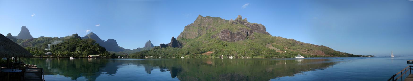
| | | | Although we were anchored at the mouth of Opunohu Bay, this is a view of Cook’s Bay: Cook’s Bay & Mountains. That would be Mount Rotui on the right, with Opunohu Bay cutting into Moorea beyond it, where that ship on the extreme right is. This also shows in the background how the rim of the crater has disintegrated into jagged peaks, which give a haunting profile, especially when seen from the distance of Tahiti, and at dawn (2009/13) or, especially, sunset.
| | | | Mount Rotui, in the center of things, is 899 m (2949 ft). Then in the semicircular rim of the south crater wall there are nine peaks that stand behind and around you when you’re at the Belvédère. The tallest by quite a bit is Mount Tohiea at 1207 m (3959 ft). I believe it’s the one at the far left. All the others are about 2/3 that height, such as Mount Mouaroa at 880 m (2886 ft), which is somewhat jagged and in the center of the picture, reflected in the water. I mention this one because it’s the most famous one on the island. | | | | Because of it’s jagged profile, Mount Mouaroa is also known informally as the Shark’s Tooth, and is often pictured. Another name for it is Mount Bali Ha’i, which is something I don’t understand.
| | | | In James Michener’s “Tales of the South Pacific”, and later in the musical “South Pacific”, he portrayed a beautiful island that was so near that it was visible, yet so far, because entry was forbidden. This island he called Bali Ha’i, and it kept two lovers separated, Joe Cable and Liat. | | | | It seems that Bali Ha’i is really a composite of many places from Michener’s experience in the South Pacific. During the war in the Pacific, he had known of an island where women and girls were sent for safety’s sake, but that was otherwise off limits. There is an island in Vanuatu that claims to be the inspiration (or an inspiration) for Bali Ha’i. And yet Moorea has of all things a mountain with that name. The situation of what Michener used as a basis is muddled. All I can guess at is this. The view of Moorea from Tahiti is gorgeous, and it is so close (however, it is not forbidden). Perhaps Moorea is one of the elements he used for his island, borrowing from it the catchy name of one of its mountains? Or did the mountain get that name (after all, it’s not the main name), only after the name of Michener’s island became famous? I do not know any of these answers, and suspect Michener kept the issue vague, so that the real answer might have died with him. | | | | That night on the ship in Moorea we had that local dance troupe described earlier, and the next day sailed to Papeete, just one week after I’d watched from my hotel the Paul Gauguin arriving there on its previous cruise. We then had a second dance troupe that last night. It was explained that after missionaries arrived in the islands in 1787 they outlawed dancing (think of “Rain”). Over the years, dance customs were practiced in secret, and then in the 1950’s, dancing was revived as part of the local Ma’ohi culture and as an art form. I should mention here that Maohi (or Ma’ohi) is the preferred word for the local Polynesian culture. It is not a coincidence that Maohi looks so similar to the Maori culture of Aotearoa (New Zealand), since they are two variations of the same word. | | | | The Return We left the ship Saturday afternoon. Some people visited Tahiti for a couple of days at this point, but most were ready to leave. The Air Tahiti Nui flights weren’t until that evening, so many took a day room at a hotel. I went back to the Hilton (ex-Sheraton) and got writing done.
| | | | The ATN flight I had booked months earlier online was at 22:00 (10 PM), and I had then arranged an American Airlines connecting flight in Los Angeles accordingly. But several months before the trip, ATN informed me that the flight would instead be leaving at 23:30 (11:30 PM), which meant that with the later arrival in LA I wouldn’t have enough time to make my connection, and my AA ticket was of the “use it or lose it” type. But AA had told me that if I informed LA shortly before my arrival that I would miss the connection, I could probably be moved to standby on their later flights from LA to NYC, which left about every two hours. This was the problem I’d been trying to resolve since Auckland, with no success.
| | | | The ATN flight to LA was 8¼ hours, plus two time zones later, and, wouldn’t you know, it arrived at a satellite terminal, where we had to take buses in to the main terminal. Going through customs took forever, and I couldn’t find any airline reps to help me with my problem. But fortunately, as I walked out of the international arrivals building, I found that AA left from right next door. I ran over, and was relieved to find that my AA flight had a 45-minute delay. But then the lines for security were endless, and I was sure I’d still miss it. Then, out of security, I saw there was a second delay for my AA flight, and I made it!
| | | | After the international flights on Air New Zealand and ATN, the pretzel-and-soda ambience of an AA domestic flight was a letdown. With the two delays, we left LA just before noon, but the duration of the flight added to crossing three more time zones in the “later” direction meant we arrived in New York at about 8 PM.
| | | | Coming from Tahiti, I had not heard anything about a possible snow storm in New York, predicted for about 9 PM. As we were landing, the pilot said it might be bumpy, but there was no problem. I took the AirTrain (automated rubber-wheeled train on an elevated track) from JFK to Jamaica Station of the Long Island Rail Road, and noticed nothing. The first time I was outside since LA was on the covered platform at Jamaica, where I waited to catch the 8:46 for Penn Station. No snow there, and I was unawares, anyway. The train went under the East River and arrived underground in Penn Station, where I took the subway to Rector Street. As I walked the 7-8 minutes home, it was my first time really outside since I arrived, and I noticed that a few snow flurries were falling. But I unpacked that evening and went to bed.
| | | | I found out the next day, Monday, that the snow was heavy enough that all the New York City schools had a snow day, something that happens more often in the inland suburbs, but more rarely where the ocean tempers the climate and often changes snow to rain. Long Island and Connecticut had up to 14 in (356 mm) of snow, New Jersey up to 12 in (305 mm). The City had less, with a reading in Central Park of 8.3 in (211 mm). Worse, I heard that overnight about 900 flights had been cancelled at New York’s three airports. That means not only that I just made it on the flight I did take, but if I’d ended up on standby on a flight two hours later, who knows where I might have spent the night.
| | | | This means that when I left New York on January 10 on the Queen Victoria, we had heavy snow flurries on the decks that first night, and when I came back on March 1, more flurries were falling.
| | | | I need to make an adjusted statement. I had said that those flurries on the QV were the first I’d ever experienced on a ship, but my friend Peter in Australia reminded me that when we all boarded the Explorer II for Antarctica in Ushuaia, we had heavy flurries across the deck there as well. He is absolutely correct, but I will say that one expects snow in that region on a trip to Antarctica (even though no snow fell after that), and one is also prepared with heavy clothing. What I meant about the flurries on the QV I meant as a highly unusual experience for me on a ship in a more usual location in a temperate climate. But still, Peter is right, it was my second such experience.
| | | | I also asked in my building about the plane that landed in the Hudson a few days after the QV had sailed by. I knew it had been towed down to Lower Manhattan where it stayed for a while, but was informed that it was moored in the river just upstream from our building, so would not have been visible from our windows. Still, when they finally removed it, it could have been a spectacular sight.
| | | |
| |
|
|
|

