|
Reflections 2009
Series 21
September 19
The Thirteen Colonies, 1600-1800: I
| | Up until now, in 2009/20 and earlier, we’ve discussed the settling of the donut, to the west, south, and north of the middle. Now we get to the hole in the donut, the US East, finally progressing downcoast from Canada to the area that eventually became the United States. I suspect many people do as I once did, telescope the colonial period in their minds to something fleeting that preceded independence. But the region we’re talking about was colonial just as about as long as it’s been independent, roughly two centuries each: 17C-18C versus 19C-20C. For easy calculation, figure settlement starting about 1600 to independence just before 1800. Those are the benchmark years we’ll use and limit ourselves to, in order to trace initial settlement developing into colonies and only at the very end into states. After 1800 would then be the period we’ve discussed earlier, the expansion from those original colonies and territories beyond, into Florida, Louisiana, and the West. This is not a history of these places. It’s an account of who settled where and formed what colonies in what became the US East, from the east coast itself inland to the rivers.
| | | | Contrary to what’s drummed into one’s head, forget Columbus. He went south, to the Bahamas and the Caribbean to be exact, and has ABSOLUTELY NOTHING to do with North America. Let those areas accept him as part of their history. For that matter, forget Cabot. He went north, and becomes much more a part of Canadian history. The earliest explorer here was Giovanni da Verrazzano (also spelled Verrazano), again an Italian like Cabot/Caboto and Columbus/Colombo, but this Italian explorer in the service of the French. Unlike the other two, there is no separate English version of his name. In 1524 he explored the east coast as far south as South Carolina, most notably New York Harbor (thus the bridge over the narrow entrance to the harbor called the Narrows is called the Verrazano Narrows Bridge). THIS is a logical and appropriate commemoration.
| | | | The limits of the U.S. east coast that we’re using for historic purposes of exploration and later settlement start below Canada, but end at the Florida line, since that is no longer the English colonization area, but part of the Spanish Gulf Coast. The coastline is the defining area (water, water, water), but the territorial claims range westward to the Lower Mississippi River (more water) and, above that, the Ohio River. These claims made early on were wishful thinking and hopes for the future, since the interior was wilderness. Therefore, as we start to discuss the area, we need to primarily cling to the coast, just as the settlers did. The interior up to the rivers was settled later on in our time period, and then beyond the rivers, even later.
| | | | Along the east coast there remains clearly visible today an area of primary settlement in the northeast, plus the very earliest of expansion areas southward. This area of primary settlement is today called the Northeast Corridor, sometimes humorously referred to as Bosnywash. This is the highly developed and populous megalopolis from Boston via New York to Washington (Bos-NY-Wash), also notably including the large cities of Philadelphia and Baltimore. (Or, if you want a more complete list: Boston MA, Providence RI, New Haven CT, New York NY, Newark NJ, Trenton NJ, Philadelphia PA, Wilmington DE, Baltimore MD, Washington DC.) This is a transportation corridor well served by road and rail, most particularly, the only high-speed rail line presently in the United States, Amtrak’s Acela (2006/11-12).
| | | | But how did this concentration of cities develop, given that the rest of the settlements south of Washington DC to the Florida line never developed large coastal cities? (Nor, for that matter, did any major ones develop to the north of Boston until you reach Halifax, Nova Scotia.) Furthermore, given this settlement pattern reaching down to Greater Washington, and considering that the United States almost disintegrated in the Civil War into North and South right at Washington on the Potomac, was the United States predestined to this fate by this coastal settlement pattern? | | | | Let’s move back four centuries to the beginning of our time line. Although Verrazano came by early in the previous century (1524), keep the year 1600 in mind as a major benchmark, since that’s when east coast settlement activity started.
| | | | There are four south-flowing rivers in the US Northeast. Three of them, from west to east, are the Susquehanna ending in Chesapeake Bay, the Delaware ending in Delaware Bay, and the Hudson ending in New York Bay. These Bays became three of the four settlement areas in the US East. The only waterway in the Northeast that never became a major settlement area was the next one to the east beyond the Hudson, the Connecticut River (2005/18) in New England, which we discussed regarding William Gillette and Sherlock Holmes (2008/14). It’s because it’s just not sufficiently navigable, since it’s heavy with silt, which forms a large sandbar near its mouth. However, the Dutch in New Amsterdam made use of it, calling it the Fresh River. New England’s primary early settlement area—the fourth one on our list—is instead represented by the hook of land reaching out to sea called Cape Cod. But since it’s the waterways that define our settlement areas, we’re here talking instead about two bays that are twin-like, Cape Cod Bay surrounded by the hooked Cape, and lying a bit northwest of that bay, and deeply indenting the coastline at Boston, Massachusetts Bay, reaching up to Cape Ann. | | | | The varying proximities of these four settlement areas should be noted: the first three are adjacent to each other, while the twin bays in New England are further distant. As an example, the Acela today speeds south from New York via Philadelphia (on the Delaware) to Washington (on the Potomac, just off Chesapeake Bay) in 2h50, while the northbound Acela to Boston takes 3h30.
| | | | It should also be noted that all four of these “coastal” areas are in reality in protected areas that are somewhat inland. The beaches of Ocean City MD and Virginia Beach VA face the sea, but the settlement areas were safely within Chesapeake Bay. The same can be said for the Delaware beaches, Jersey Shore beaches, and Long Island beaches, while Philadelphia and New York are upstream. Finally, the eastern side of Cape Cod takes the brunt of the weather, while the two bays are more protected internally.
| | | | For this discussion, we will work from south to north, starting with Carolina, then move on to the four settlement areas, ending in Cape Cod. This is not to be understood necessarily as the sequence of settlement, but is just for convenience of description. The map shows so many states that just look like jigsaw puzzle pieces with no apparent relationship to anything. I find looking at this region in its historical context makes a lot of sense out of the apparent chaos. The ultimate goal here is geographic clarity, that is, to organize in our minds the colonies and which states developed from them.
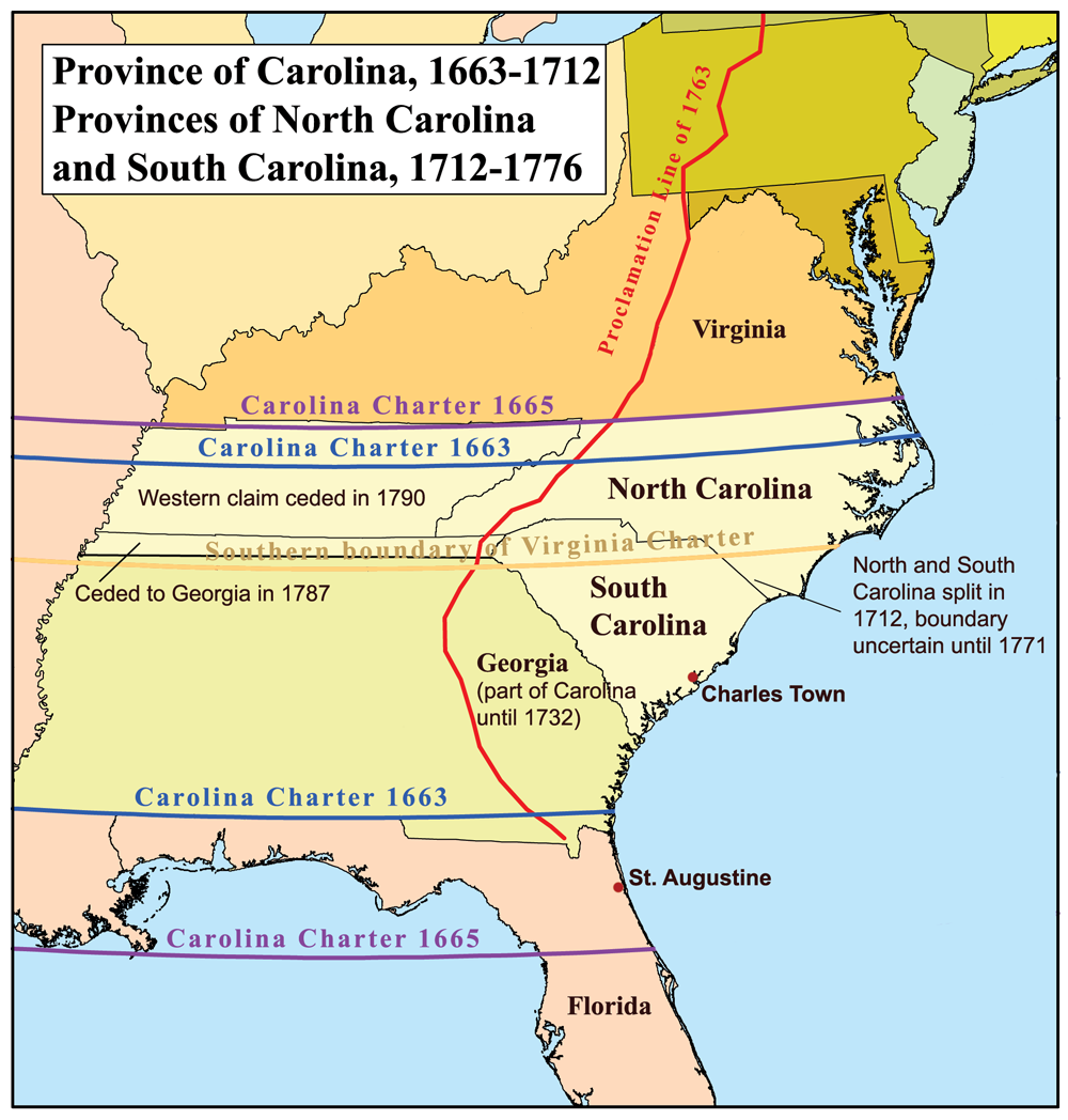
| | | | Province of Carolina We start with the southernmost entity just above Florida, the colony called the Province of Carolina, which became three other Provinces before independence, and subsequently six states. It was therefore larger than you may imagine, and started as a colony later in the colonial period, the 1660’s, after all the colonies to the north of it, so that the three colonies developing from it were among the latest of all. It was also very heavily settled overland from Virginia and not necessarily from coastal settlement areas, making it de facto the first expansion area within the borders of what we consider the original colonies.
| | | | Group together North Carolina and South Carolina (of course!), but also include Georgia into the former single colony they once were. But then keep on including territory until you reach the Mississippi. You will have covered six modern states. This was Carolina, as founded in two charters which each varied as to the location of the upper and lower borders. The lower border of the 1663 charter became definitive, and ran more or less along the present Florida border to the Mississippi. But upper border of the 1665 charter was the one that became definitive, and is the North Carolina border of today, but running to the Mississippi. (You will always find wishful thinking in these newly established entities. Although we realize that further west, a large Louisiana developed into to many states only one of which is modern Louisiana, I suspect that few people realize the large size of Carolina—and others, such as Virginia—that became multiple states.)
| | | | [But we have to mention one chaotic point, that of the very earliest settlement of all, Roanoke, made long before the settlements in the northeast. Roanoke was unsuccessful. The much earlier 1609 charter establishing Virginia, the oldest colony, had set Virginia’s borders wildly askew. Virginia’s southern border was put in a location that today would have included Tennessee and North Carolina, and its northern border ran at an angle from southern New Jersey through Lake Superior! These early oversized Virginia borders has led to confusion about which colony Roanoke was established in. These are the facts: just inside the islands of the Outer Banks of today’s North Carolina, near the Wright Brothers’ Kitty Hawk, is Roanoke Island. This is the supposed site of the Roanoke Colony, organized and founded (but never visited) by Sir Walter Raleigh between 1585 and 1587. It became the famous “Lost Colony” when people stopping there later found that all trace of it was gone. This had been an attempt to settle people in what was at the time the Virginia Colony, as earlier defined, but after the failure of Roanoke, it was decided that Chesapeake Bay, further north in what today is indeed Virginia, was more favorable, and Jamestown was then founded there instead. There is also a famous name associated with Roanoke Colony, Virginia Dare, the first child born in the Americas to English parents, on 18 August 1587. Her date of death is unknown, as is the case with all the Roanoke colonists. Note that she was indeed named Virginia. The point is, Roanoke was established in what was Virginia in the 1580’s, but which became Carolina in the 1660’s, specifically North Carolina today.]
| | | | So let’s go back to our original consideration of Carolina as one large unit dating from 1663-5, and named for Charles I. It didn’t last in a united form. By 1691 there was dissent as to how the government was being run, and a deputy governor was dispatched to run the northern part, and the division between north and south became complete by 1712. So what did we have now? Carolina was in two parts, but not what you’re picturing. North Carolina in the east looked like what it does today, but extended in a HUGE panhandle (the present Tennessee) to the Mississippi. And South Carolina? Its territory covered all the rest to the south, so that at this point, SC was larger than NC!
| | | | But not for long. In 1732, George II issued a charter for Georgia (named for himself), to be carved out of SC. With this three-way division of the original Carolina, the small, triangular SC we know today retained for many years a ridiculously thin panhandle running to the Mississippi (eventually ceded to Georgia), and Georgia had all the rest below that. This triple-wide Georgia was then the largest of the three (NC, SC, GA), all running to the Mississippi.
| | | | Also, a note on terminology: although we commonly refer to all thirteen as colonies, “colony” was the official designation of only four, Virginia, Delaware, Connecticut, and Rhode Island. The other nine were referred to as “province”, as Canadian subdivisions still are to this day. Now that we’ve discussed all of Carolina, see on this map how the Province of Carolina became three Provinces early on (note that the title fails to mention Georgia): Province of Carolina
| | | | Of the 13 original colonies, Virginia is the oldest (1609), and Georgia, the last colonial subdivision of Carolina, the very youngest (1732). Also consider that about half the colonies were larger than the states with the same name today, and that the signatory of the Declaration of Independence representing each colony was representing the area of more modern states than one might realize.
| | | | Both Savannah GA and Charleston SC are coastal cities and ports of exemplary interest, yet neither developed as a powerhouse as happened in the Northeast Corridor. The modern regional powerhouse and hub that did develop was Atlanta starting in 1847, but that happened inland, since Atlanta developed as a railroad junction and not a port. There is further irony in that non-coastal Atlanta is indirectly named after the Atlantic Ocean. | | | | After the Revolutionary War, the western extensions in all colonies that had them saw change, and how and why this happened will be explained later. But these are the changes that took place: the long panhandle of North Carolina (“double-wide NC”) became the state of Tennessee in 1796 (see Carolina map above). In 1787 the slender panhandle of South Carolina was ceded to triple-wide Georgia below it. As for the western 2/3 of Georgia, the lower third of it was for some time in dispute with Spain’s West Florida, but when that was settled, the entire area was on its way to becoming the states of Alabama and Mississippi, as shown here: Alabama & Mississippi I find some curiosities here. First, of all areas along either bank of the Mississippi River along its entire length that could have been named after the river, it specifically was the westernmost end of an east coast state like Georgia of all things, that gained that distinction. Second, note the unusual change in orientation that happens. In 1812, the two central portions of West Florida, which by that time was part of the US, were annexed to Mississippi and Alabama as panhandles, as shown on the map. Thus, two regions that had been historically oriented to the east coast and therefore an extension of it were “turned around” to be oriented to the Gulf Coast (water, water, water). Third, these twin panhandles reaching over the Florida line were the only “stepping over the border” into new, external territory of any of the thirteen colonies.
| | | | [I also find the fate of the rest of the Florida panhandle of interest. Mississippi didn’t get all West Florida that lies to its south—Louisiana got a piece. Also, Alabama didn’t get all to ITS south, and Georgia didn’t get any at all. Logically, what remains today as the Florida panhandle is still the natural coastline of eastern Alabama and western Georgia. (Georgia could have had two coasts.) While peninsular Florida is visited by northerners, Canadians, and Europeans, it’s the Florida panhandle (the “redneck riviera”) that draws people from Alabama and Georgia to what remains to this day essentially their natural coastline.] | | | | There are two pairs of states that can be referred to collectively, the Dakotas and the Carolinas (but no one combines West Virginia and Virginia into “the Virginias”). They also can be referred to collectively in the singular, as in “I have family in Dakota”, without specifying which one, or in the song “Carolina in the Morning” (1922), which opens “Nothing could be finer than to be in Carolina in the morning …” Both NC and SC claim this song as their own, but no one thinks about all the other states that once were part of Carolina. It just goes to prove that proper naming can show heritage, but if your name doesn’t refer to your heritage, no one knows who you are.
| | | | [I found some very interesting news about this song. It debuted in a very risqué musical review on Broadway called “The Passing Show of 1922”, and was introduced and sung by none other than William Frawley, who would have been 35 at the time. He later sang it as Fred Mertz on an episode of “I Love Lucy”. When he did, I would imagine few people would have known that he was the one who had introduced it on Broadway.
| | | | It is totally unclear from the context which of the Carolinas is being referred to in the song, if either, and given the risqué nature of the show it appeared in, it is also possible that it refers to a woman named Carolina, in which case the opening line takes on a TOTALLY different meaning.
| | | | After a bit more research on Frawley, I find he also introduced the song “Melancholy Baby” in 1912, and “Mammy”, later Al Jolson’s signature song, in 1918. Who knew?]
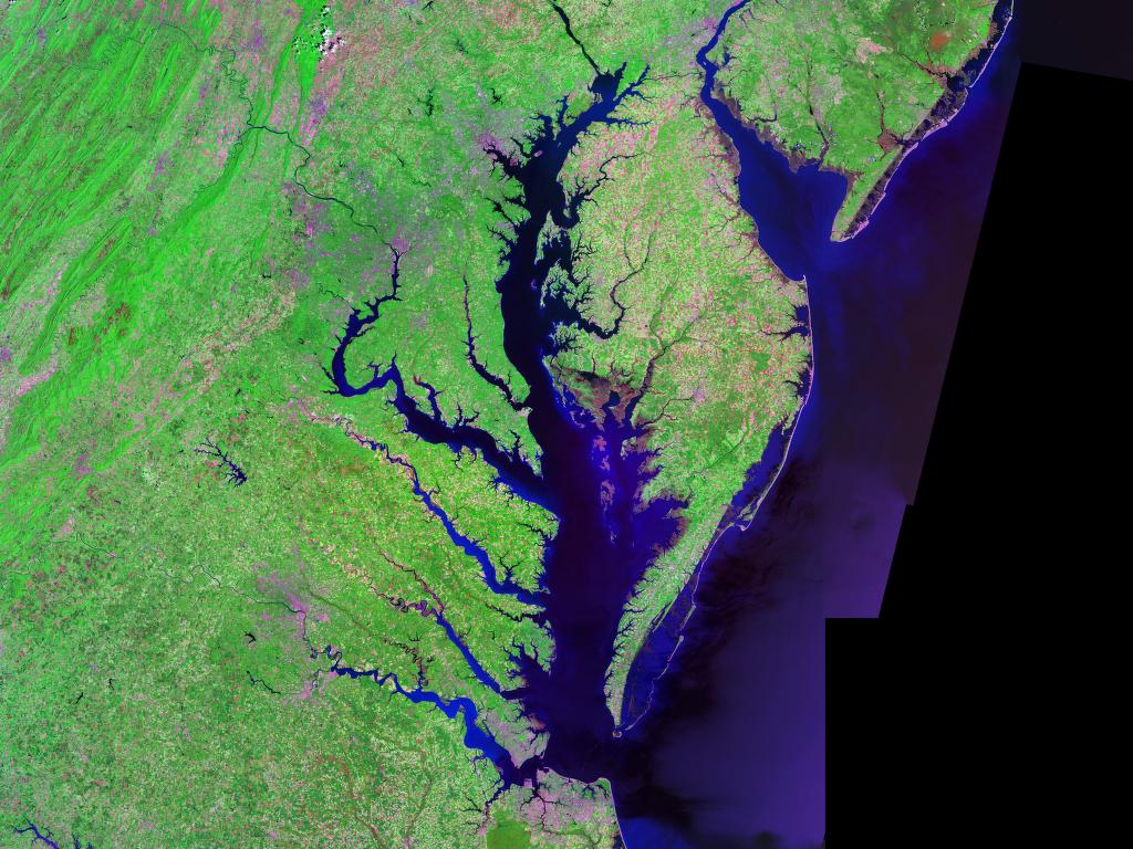
| | | | Chesapeake Bay: A Settlement Area Given the failure of Roanoke Colony further south, British settlers looked up the coast to Chesapeake Bay, which perhaps seemed more propitious. Chesapeake Bay, one of the four major east coast settlement areas—as a matter of fact, the first--is a geographic anomaly. To show what it looks like, rather than using a map with political borders, look at this satellite image, which also has the advantage of suggesting what the area looked like when settlers arrived: Chesapeake Bay, Delmarva Peninsula, Delaware Bay | | | | The Susquehanna River, at 715 km / 444 mi the longest river on the American east coast, comes down from New York State, through all of Pennsylvania, then into Maryland to enter, at the top of the image, the upper Chesapeake, which is the largest estuary in the US. The Bay runs some 300 km / 200 mi south from the river entrance, then makes a dog-leg east to the open ocean. Very visible on its western side, four rivers enter. Most striking is the Potomac (Washington DC) which has a very wide estuary of its own, making it the defining feature in the Bay area, so much so that it became the division between Virginia (to the south) and Maryland (to the north). South of the Potomac is the Rappahannock (George Washington boyhood home), the York (British surrender at Yorktown), and the James (Jamestown, first settlement). This is already an indication of the breathtaking array of early American history associated with the (Virginian) west side of the Chesapeake covering the very period we’re talking about (from Jamestown in 1607 to Yorktown in 1781).
| | | | The Potomac is of further importance in dividing the colonies, and later states, of Virginia and Maryland in that the border between them extends from the south bank of the Potomac across the Bay and then across the Delmarva Peninsula to the open ocean. In other words, from the beginning, that slender “tail” of the peninsula has been part of Virginia, called the Eastern Shore of Virginia. Above that, on the Bay side, is the famous and historic Eastern Shore of Maryland, whose central river is the Choptank, described in fictionalized detail by James Michener in his 1974 “Chesapeake”, as is the whole Bay from the earliest settlements to the present. On the other side of the peninsula is the nearby Delaware Bay descending from the Delaware River, to be described later. Since the state of Delaware faces Delaware Bay, the three states lend their name to the Delmarva Peninsula (Del-Mar-Va). At its southern tip, the Chesapeake Bay Bridge-Tunnel (1964, 37 km, 23 mi) brings traffic today over bridges and tunnels via four artificial islands across the entrance to the Bay. It was shortly after Beverly and I read Michener that we felt so engrossed by its history that we spent the week of a spring vacation encircling the bay, experiencing the nature and the history. We drove down the peninsula, crossed the Bridge-Tunnel, then came up the western side visiting sites we hadn’t seen on other trips.
| | | | But why is this huge estuary of the Chesapeake an anomaly? Looking at the map, try this. Reach your hand underneath the east coast at this point, and gently pull up. As you lift the coast, the water starts to flood out of the Bay through its broad entrance until most of this extra water is gone, and both shorelines get wider and wider. Now look at what’s left, and you’ll be surprised. You are looking at the lower half of the Susquehanna, which you now realize is longer than ever as it flows down into the sea, so that what was the broad mouth of the bay is really the narrower mouth of the river. Not only that, but you now see that the rivers coming from west and east are actually tributaries of the Susquehanna. The whole area is transformed. But alas, this is not to remain, so gently lower the coastline again and watch the ocean flood back in, reconstituting the wide bay and once again giving the appearance of the separate rivers they all are today and no longer the cluster of river-with-tributaries that they once were. This flooding has also guided settlement. The Susquehanna River itself, as it remains today, was never heavily settled; rather it was the Chesapeake and the ex-tributaries that reaped the benefits of settlement.
| | | |
| |
|
|
|

