|
Reflections 2009
Series 23
September 19
The Thirteen Colonies, 1600-1800: III
| | Delaware Bay: A Settlement Area You will have noted that when you lifted up the east coast earlier and the Chesapeake drained out that the same thing would happen to Delaware Bay, thereby allowing the Delaware River to drain further south and closer to the Atlantic. Note the area on this map of the Province of Pennsylvania (Map by Kmusser) that, to this day, the river comes down from New York to form the border between it and Pennsylvania, then separates New Jersey from Pennsylvania, and that finally Delaware Bay itself separates New Jersey from Delaware. Similar to how the Potomac divided Virginia from Maryland the Delaware divides even more abruptly and totally—on the west bank is Pennsylvania and Delaware, and on the east bank, New Jersey, and also New York.
| | | | Although Verrazano had visited the area in the previous century, it’s Henry Hudson’s visit just four centuries ago this year, in 1609, that is more closely connected with settling. Hudson, an Englishman working for the Dutch (for once, it wasn’t an Italian working for someone else), came down the cast along present-day Canada, made a landfall at Cape Cod, then ran down to the Chesapeake and only peeked in, for fear of disturbing the English colony at Jamestown, then visited Delaware Bay, and finally New York Bay and the Hudson River (see below).
| | | | It has to be realized that in the early 1600’s, not only was Great Britain a major power, but so were the Netherlands and Sweden. The Netherlands (with Flanders) was in its Golden Age in the arts, sciences, politics, and exploration, and Sweden at that time owned territories all around the Baltic, including in Russia. It should not surprise that the Netherlands, but also Sweden, should have been interested in settling the New World.
| | | | Of our four regions, we should remember that the British settled the two that were furthest apart, Chesapeake Bay, and Cape Cod & Massachusetts Bays; New York Bay was Dutch, then British, but Delaware Bay had three layers of settlement, Swedish, then Dutch, then British.
| | | | Actually, the Dutch got to the Delaware first, based on Hudson’s exploring. They were the ones who named the two capes at the entrance to the Bay, Cape Henlopen on the south (Delaware) side and Cape May on the north (New Jersey) side. These names were then slightly altered from the original, having been named after a Dutch trader, Hinlopen, and Dutch explorer, Mey. Near what is today the Delaware town of Lewes (pronounced Lewis) the Dutch founded in 1631 what it still called Zwaanendael (“Swan Valley”, spelled Swaanendael at the time, but which would be Zwaanendal in today’s spelling), which I have visited, as I have a number of the locations we’re discussing. But the community was attacked by Native Americans within the first year and was wiped out, so no permanent community remained.
| | | | Thus, when the Swedes arrived seven years later, in 1638, they were the first to found something that lasted, which they called Nya Sverige / New Sweden. They arrived on the ship Kalmar Nyckel (Key of Kalmar [a Swedish city]; a replica was launched in Wilmington in 1997). The colony was not on the Bay but further upstream, on both sides of the lower river: Nya Sverige & Nieuw Nederland Their primary settlement was Fort Christina (1638), today part of Wilmington DE. But there were constant skirmishes with the Dutch in Nieuw Nederland, which ended up taking over the colony in 1655 and incorporating it into its holdings on the Hudson. Thus, Nya Sverige lasted only 17 years, 1638-1655. The remnants we see today are three Swedish churches, in Wilmington, Philadelphia, and the appropriately named Swedesboro, New Jersey, which was founded as Sveaborg in 1642. The only other remaining town is nearby Bridgeport NJ, founded as Nya Stockholm.
| | | | I was surprised to find out that the greatest contribution of New Sweden to the New World is the log cabin, the concept of which was brought from the woods of Scandinavia and Finland, and which has become so iconic that it is considered quintessentially American—as American as Abraham Lincoln. The oldest existing log cabin in the US is at a landmarked site in Swedesboro, and particularly New Jersey settlers continued to make extensive use of this kind of dwelling.
| | | | But nothing lasts. The Dutch took over 17-year-old New Sweden in 1655, but Nieuw Nederland was itself taken over by our third player in the area, Great Britain, just nine years later, in 1664, at which point all four settlement areas were exclusively British. New Netherland became New York, which means that for a decade, until 1674, the future New Jersey was part of New York, and the entire west bank of the Delaware was in flux. It would be at this time that the river, bay, and future colony were named after Thomas West, Baron De La Warr, Virginia’s first colonial governor.
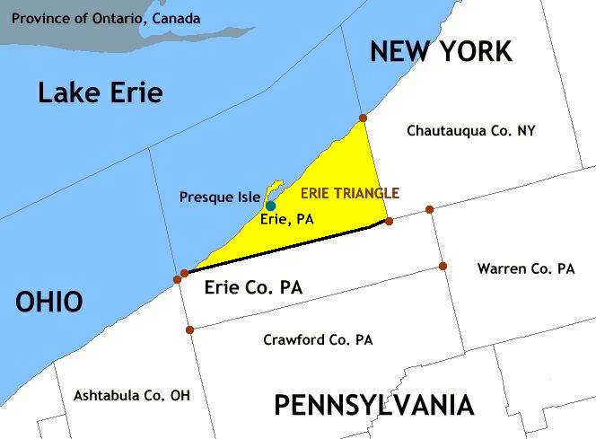
| | | | Province of Pennsylvania & Colony of Delaware After the 1664 takeover by Britain of New Netherland (with New Sweden) and the conversion of all of New Netherland to the Province of New York, named after James, Duke of York, brother of Charles II, the entire Delaware River region logically became part of the Province of New York. Then in 1681, Charles II issued a charter to William Penn, who established the Province of Pennsylvania on the west bank of the upper river, along with Philadelphia (sylva is Latin for forest, as in the word “sylvan”, so the name means “Penn’s Woods”). But Penn wanted to consolidate the entire west bank into his new colony, and he asked the Duke of York for, and received, the balance of the west bank, what is today the state of Delaware. Still, the two areas never fully merged. As Pennsylvania grew in size inland, Delaware’s three counties (it’s the second-smallest state after Rhode Island) remained hemmed in along the shore of the river, back-to-back with Maryland on the Chesapeake. Penn also had a hard time running what was referred to as “the Three Lower Counties on the Delaware” along with Pennsylvania, and was unsuccessful in merging their governments. Finally, in 1701, he agreed to forming two separate assemblies, one in Philadelphia and one in New Castle. By 1704 the division was essentially complete, still Delaware remained to some extent a satellite of Pennsylvania. For a while, the two “Siamese twin” colonies even had the same governor. The Colony of Delaware existed under the influence of the wide economic and political circle of Philadelphia until US independence in 1776. | | | | Speaking of that date, I’ll remind that Philadelphia, on the edge of the Delaware, was the site of independence deliberations resulting in the Declaration of Independence in the summer of that year, and that at the end of that year, the event most famously associated with the river occurred. North of Philadelphia, it was planned for armies to attack the British on the New Jersey side, near Trenton. In a surprise move, the decision was made to arrive near Trenton on the evening of Christmas Day, a time that wouldn’t be expected. The surprise move worked, and the next day, the Americans won the Battle of Trenton. What is so unusual is that the battle itself is not as famous as the ARRIVAL of the American troops, which stands out famously in people’s minds. Probably decisive in why that is so is the idealized painting done 75 years later, in 1851, by a German-American Philadelphia artist, Emanuel Leutze, a painting hanging today in New York’s Metropolitan Museum of Art called Washington Crossing the Delaware. | | | | Given Pennsylvania’s successful expansion to the west, I’ll only fleetingly remind about the fact that, while eastern Pennsylvania is oriented to the Delaware and thereby the Atlantic Ocean, western Pennsylvania at Pittsburgh is oriented toward the Ohio River leading to New Orleans, and that the Pennsylvania Canal was built to connect them, including the fabulous Allegheny Portage Railroad (2006/10), which existed for just twenty years (1834-1854). | | | | And while we’re thinking about western Pennsylvania, we have to talk about the Erie Triangle, which is the “chimney” at the northwestern corner of the state (see map above). This piece of land was the subject of multiple claims, by adjacent New York and Pennsylvania, as well as more distant Massachusetts and Connecticut. The Erie Triangle was acquired by the federal government and sold—sold!—to Pennsylvania in 1792 to give it Lake Erie frontage. Note on this closer map of the Erie Triangle that, even if NY had acquired it, it wouldn’t have quite reached Ohio, since no tripoint could have been formed.
| | | | Finally, for this area, we come to the most unusual state line in the US, and probably internationally as well. It lies on the Delaware on one end, and adjoins the more famous Mason-Dixon Line on the other. It’s called the Twelve-Mile Circle. It was promulgated in 1750, the same year of the court ruling that confirmed the agreement on the MDL. This is the unique circular border that solves the sensitive issue of separating Delaware from Pennsylvania. I can phrase it that way, since the concave side faces Delaware and its centerpoint is in Delaware. The name is somewhat of a misnomer, since it isn’t an entire circle, but instead just an arc of a circle, yet there’s still more to it than meets the eye. Look at this map of the Twelve-Mile Circle.
| | | | Delaware’s big city, Wilmington, falls within this arc, and is part of the Northeast Corridor coming up from Baltimore that goes on to Philadelphia, Trenton, Newark, New York, and beyond. But a short distance south of Wilmington is the historic Delaware city of New Castle, which was the colonial capital. The New Castle Court House served as the state house at the time, and it was the cupola of this building that was used to determine the center of the circle, with a radius of 12 mi / 19.3 km. Actually, although it was promulgated in 1750, the circle actually dates back to the original deed of Delaware by the Duke of York to William Penn of 24 August 1682.
| | | | Aside from the visible arc of the border, the deed is specific about the river. Usually, political borders on rivers run down the center of the river. If you look at this last map, you’ll see that’s true in the north and south. But within the circle, the entire Delaware River is part of Delaware up to the high-water mark on the opposite shore. This means that, when the Delaware Memorial Bridge was built between Delaware and New Jersey, it stood entirely within Delaware, and New Jersey was not required to participate financially in its construction.
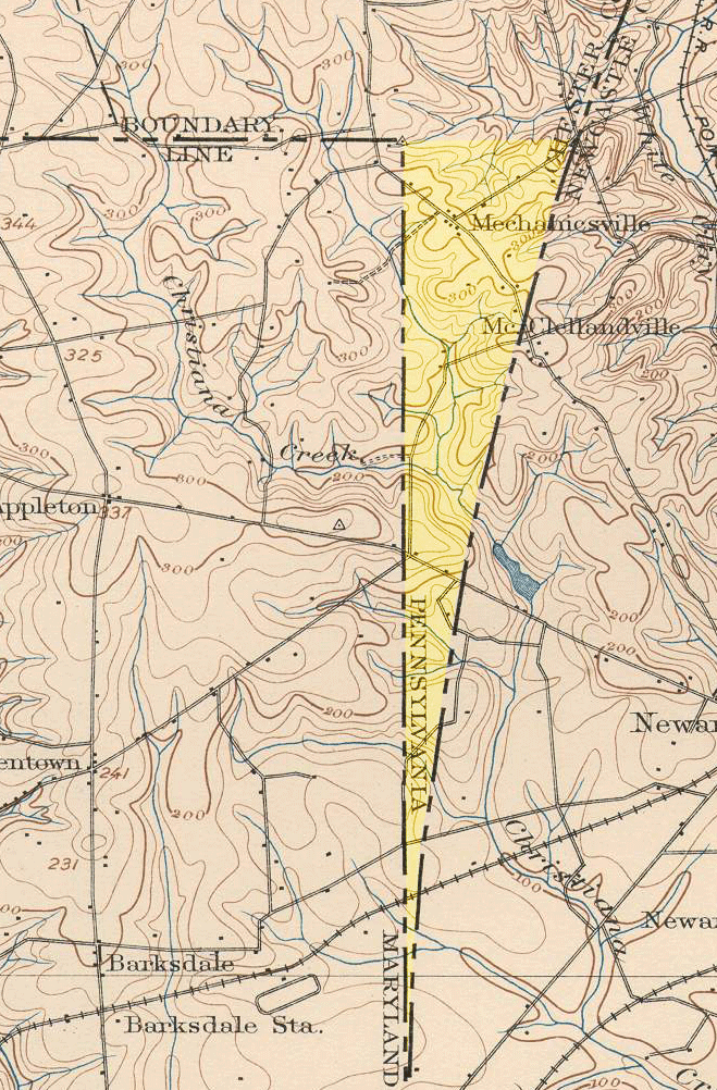
| | | | This unusual river border has another odd affect. Note on the map where the bottom of the circle crosses the river, and cuts off a small peninsula in New Jersey. This peninsula is in Delaware, which means that here you can walk on dry land between the states, which are otherwise nominally across the river from each other. If you then continue around the circle, you’ll find the point where the circle is virtually contiguous with the Mason-Dixon Line touching Maryland. And then this brings us to the geopolitical anomaly called the Delaware Wedge. | | | | I’d always wondered that the circle never quite met up with the rest of the border properly, and now I find that that’s been an issue for quite a while. Due to imprecise surveying techniques at the time, the circle hits the N-S portion of the MDL about 5 km (3 mi) south of its upper corner, as shown in this map of the Delaware Wedge before the problem was resolved. The top of the wedge is only about 1.2 km (0.75 mi) across, and its area is about 3 km² (1 mi²). For a long time, no one worried about this anomaly due to the close relationship between Pennsylvania and Delaware (Maryland was safely on the other side of the MDL) and there was no drive to correct it. But then Pennsylvania claimed the Wedge, logically by default, since Delaware was on the other side of the circle. This would have then been the southernmost point in Pennsylvania. But Delaware claimed it, since it was never intended that Pennsylvania should go south of the northern border of Maryland. In 1892, the US Coast & Geodetic Survey laid out an eastern extension of the MD-PA border, naming it the “Top of the Wedge Line”. Still it remained in dispute until 1921, when Pennsylvania confirmed Delaware’s ownership. Note on the map that two DE state highways cross the Wedge, leading to Newark, one from MD and one from PA, this latter one passing very close to the tripoint.
| | | | New York Bay: A Settlement Area The next settlement area up the coast, just beyond New Jersey, is New York Bay, into which the Hudson River flows. It was also the center of New Netherland, and the location of its capital, New Amsterdam. Actually, New Netherland claimed lands from today’s Delaware up to the extreme southwest corner of Cape Cod, an area covering three of the region’s rivers, all except the Susquehanna. The Dutch names for these rivers were neither the earlier Native American names, nor the later names given by the British, which we use today. The Delaware was the South River, the Hudson was the North River, and the Connecticut was the Fresh River.
| | | | First absorb that, then consider why what I just told you was a blatant untruth, but one that history books do all the time without shame, since rarely do historians have much language sensibility. Why would the Dutch have named the rivers in English? So now let’s tell the truth. The Delaware was the Zuid Rivier, the Hudson was the Noord Rivier, and the Connecticut was the Verse Rivier (although at the time, they used the old spellings Zuyd, Noort, Versche). Of the three names, only the Dutch name for the Hudson has barely squeaked its way into the 21C in the form North River. That term, when used, does not refer to the entire river, but just the very end of it that runs along Manhattan island. For instance, the piers that used to line the West Side of Manhattan were often called the North River piers, but the name has gradually almost died out during the 20C. Furthermore, some people misinterpret the name as being in contrast to the East River on the other side of Manhattan, but that doesn’t make sense—it would have had to have been “West River”.
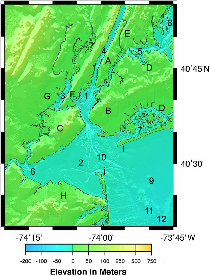
| | | | This map of New York Harbor shows it is actually a complex of bays, rivers, and straits, yet essentially it is defined by the Hudson River (4) entering Upper New York Bay (1), which is connected in hour-glass fashion by the Narrows (spanned by the Verrazano Narrows Bridge) to the much larger Lower New York Bay (2). On the west side of the upper part of Upper New York bay are two flecks of islands that are very famous. The one most visible from ships entering through the Narrows is Liberty Island, with the Statue, and behind it is Ellis Island. In that same area on the east side is the somewhat larger Governor’s Island, the first landing place of the Dutch.
| | | | There are only three other rivers of note in this complex (all in New Jersey), which could have once been tributaries of the Hudson, but which now flow into various adjoining bays. The Passaic and Hackensack Rivers flow into Newark Bay (3), which is further connected by the strait known as Kill Van Kull to Upper NY Bay. Raritan Bay (6) receives the Raritan River from the west, and is further connected by the strait known as Arthur Kill to Newark Bay. Thus, two Kills separate New York’s Staten Island (C) from New Jersey (FGH); it the only part of New York on the western side of the complex.
| | | | On the eastern side, the strait known as the East River (5) connects Upper NY Bay with Long Island Sound (8). To the NW of the East River are Manhattan (A) and the Bronx (E), which are further separated from each other by the strait known as the Harlem River, making the Bronx the only part of New York city located on the North American mainland. To the SW of the East River are Brooklyn (B), Queens (D), and, continuing to the east, the rest of Long Island, the longest and largest island in the contiguous US (190 km / 118 mi). To the south is Jamaica Bay (7).
| | | | There are no capes at the entrance to the Bay as there are to all the other settlement bays. However, the entrance is marked by two sand spits (with excellent beaches—and views), Sandy Hook (j) in New Jersey and Rockaway (or Breezy) Point (i) at the end of the Rockaway Peninsula in Queens. Between them is Ambrose Channel (10), the shipping channel into the Harbor of New York and New Jersey.
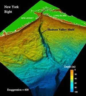
| | | | The Atlantic Ocean outside this complex is almost in the form of a right angle, and is called the New York Bight (9). It is the location, perhaps surprisingly, of the Hudson Canyon (12). Note that the depth in this illustration of the Hudson Canyon is exaggerated for illustrative purposes.
| | | | It was formed during the last Ice Age over 10,000 years ago, when the sea level was 120 m (400 ft) lower than today, and the mouth of the Hudson River was near the edge of the continental shelf, about 160 km (100 mi) east of the present mouth. It was carved by sediment coming down the river. The canyon walls rise some 1.2 km (0.75 mi) from the canyon floor, making it comparable to the Grand Canyon (2007/14). The Hudson Canyon is the most obvious indication that if you lifted the east coast high enough to drain the bays as discussed earlier, each of the rivers would revert to their earlier position, and you’d see the Hudson River return to its bed within the Hudson Canyon.
| | | |
| |
|
|
|

