|
Reflections 2009
Series 34
October 24
Japan I: Shinkansen (Bullet Train) - Seikan Tunnel
| | Pacific Overtures In 1854, Commodore Matthew Perry of the United States Navy arrived in the closed society of Japan and signed a treaty forcing Japan’s opening to the outside world. Actually, he had visited previously in 1853, so the Japanese knew changes were coming. One of Stephen Sondheim’s less heralded works is Pacific Overturesof 1976, for which he wrote both music and lyrics, which is based on this event. We thoroughly enjoyed the show then, and I also enjoyed the revival in 2004-5 at Studio 54 with B. D. Wong in the lead. It is set in 1853 and the following years, where everything is totally traditional in the mid-19C shogun’s court, but there is an inkling that change is coming. We then watch how that change takes place, which make the irony of the double-entendre of the title perfectly clear that the Western initiatives were hardly “pacific overtures”, or “peaceful openings”. The atmosphere of mid-19C Japan is presented in kabuki style, with men playing women’s roles, and with scene changes done by men in black in full view of the audience. The finale shifts abruptly and memorably. The scene suddenly jumps from the 1850’s to the present and the people that had been members of the shogun’s court are now all dressed in contemporary Western three-piece suits. Statistics are boldly announced over the singing about the growth of modern industry, airlines, manufacturing, the contemporary Japanese world presence. The variety of familiar Japanese brands mentioned is startling. It’s an amazing closing showing the change having taken place in a mere century-and-a-half. | | | | Japanese Products In that same spirit, I recently decided to review Japanese products I had at home. I knew I had a few, and had never gone out of my way to “buy Japanese”. But apparently I have. | | | | Our everyday china (how ironic that word is!) is Japanese Mikasa. Our good china is Noritake. I have two Mitsubishi TV’s, one Mitsubishi VCR, and a Sony tape player. My radio receiver is a Rotel, as is my CD player. My phone, both upstairs and down, is Uniden. My printer, my scanner, and my fax machine are all Canon. Although my present laptop is a non-Japanese Dell, my previous one was a Fujitsu and the one before that was a Toshiba. The last car I owned, from 2001-2008, was a Lexus. And the last time I was in Nordstrom’s fragrance department the saleswoman convinced me to get some Hanae Mori cologne. In some cases, I didn’t even know the products were Japanese (Rotel, Uniden) until I recently looked them up.
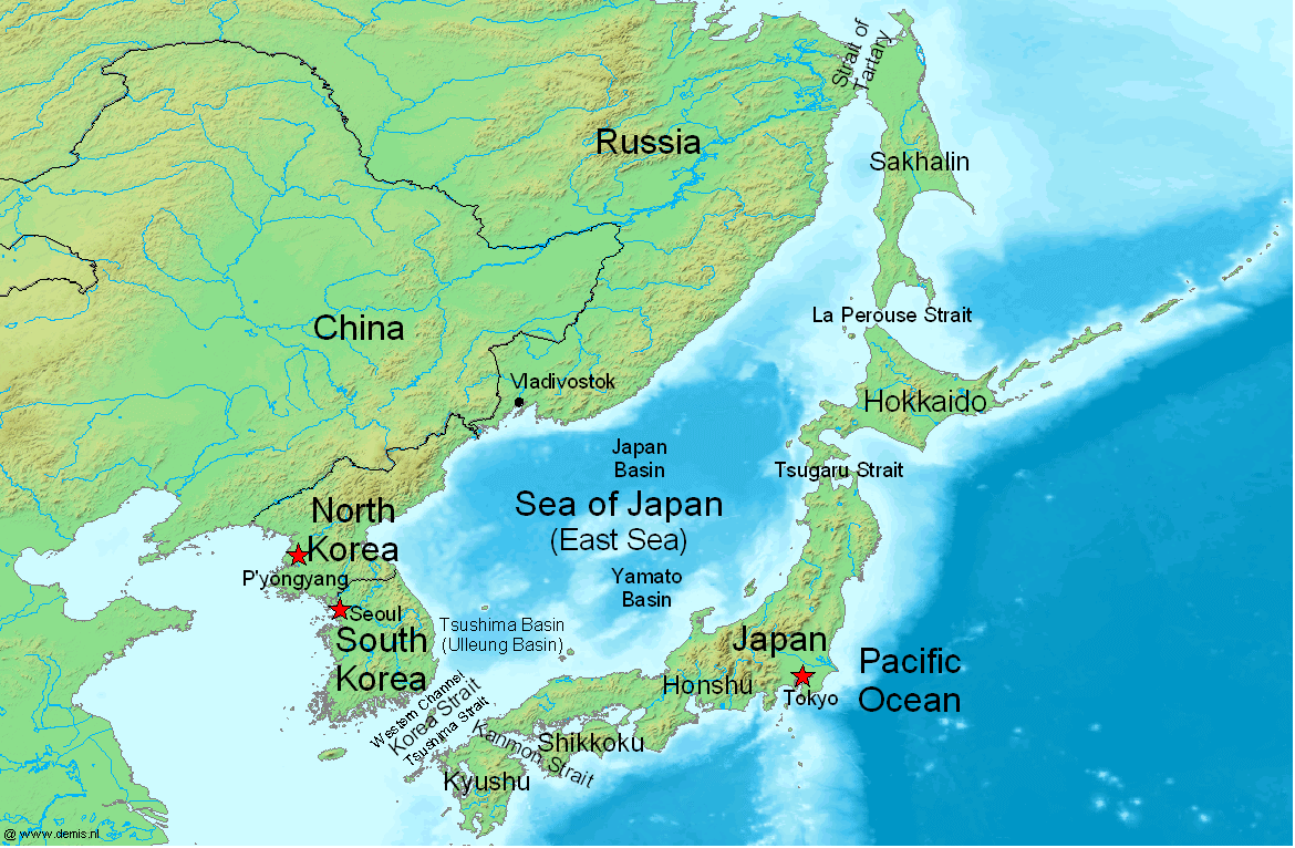
| | | | [I liked the cologne, but wasn’t too sure what Hanae Mori meant, but after looking up the name, now I know she’s one of the most prominent and respected fashion designers in Japan, Paris, and New York. Her name, in authentic Japanese word order for names, is Mori Hanae, which appears in kanji as 森 英恵. Now I’m really curious about her surname, Mori, which seems to be our familiar symbol for “forest”. Can we assume her last name means that? It could be, but we have to be careful about jumping to conclusions.] | | | | Japan the Destination I want to repeat here a map of the Sea of Japan from 2009/29, which shows Japan’s placement near Russia’s Far East and south of Russia’s island of Sakhalin, but then curving arm-like toward South Korea. Again, there’s a political conflict in the name, since Korea considers it the East Sea. There are almost no tides due to its nearly complete enclosure; it’s connected to the outside by the five straits shown. The Sea of Japan therefore contrasts to the open Pacific Ocean to the east of Japan.
| | | | Japan extends in an arc for 2898 km (1800 mi), but its broadest point is only 403 km (250 mi) across. Japan’s landmass is just smaller than California in area, but it has 42% of the US population. Still, since ¾ of Japan is mountainous, the people live on only 10% of the land. Nevertheless, Japan’s population of 128 million is the world’s tenth largest.
| | | | Note the four main islands. While three are connected by roads, all four are connected by rail. The largest, where 80% of the population lives, is in the center, Honshū, with Tokyo indicated at the “elbow”. Hokkaidō is the large one to the north, Kyūshū is to the south, and Shikoku is the small one on the Pacific side.
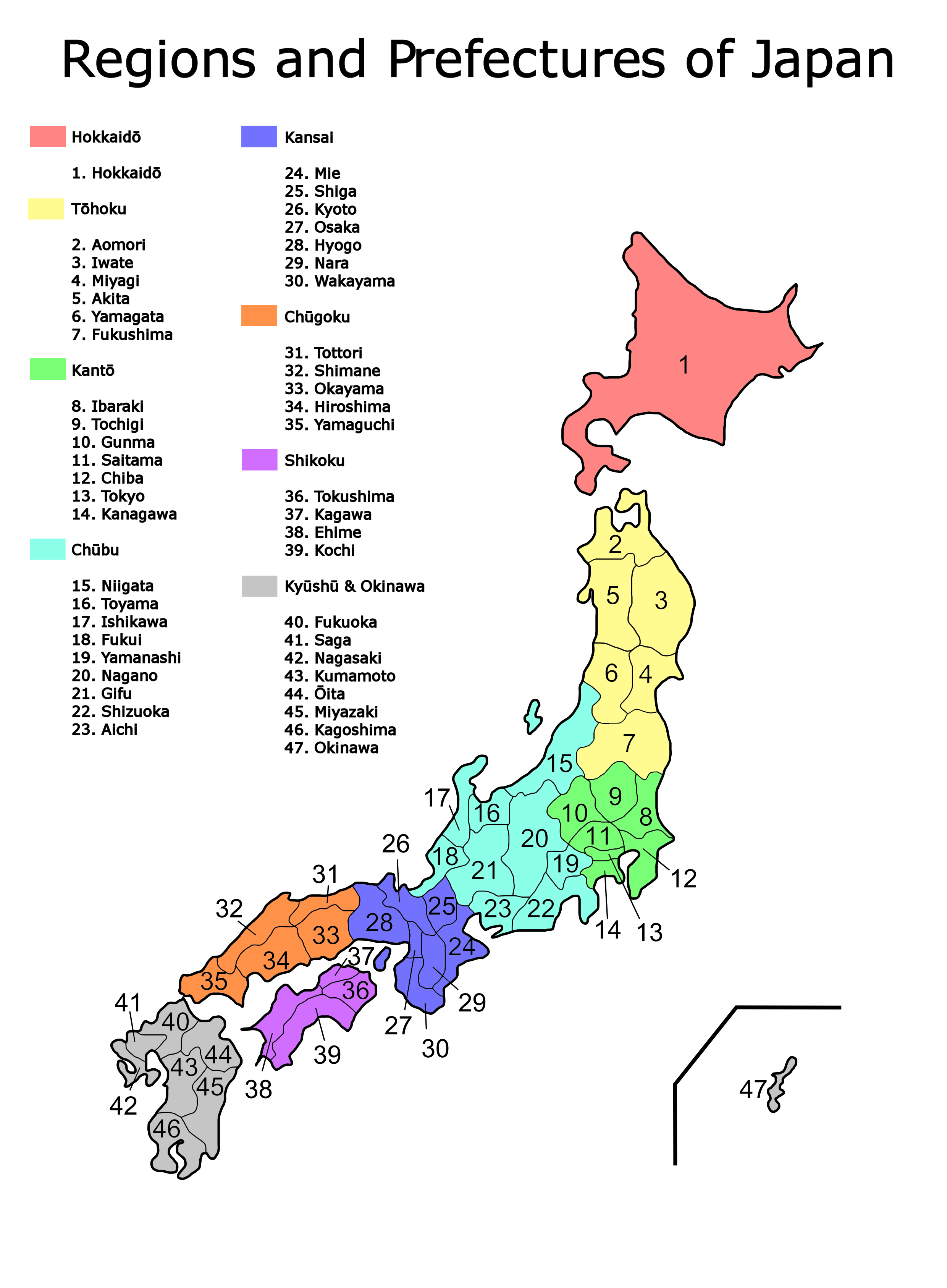
| | | | There are other details on this map of the Regions and Prefectures of Japan. Honshu in the center is shown here colored in five regions. Tokyo is in prefecture #13, Osaka #27, with Kyoto next door at # 27. The corridor between Tokyo and Osaka/Kyoto is the main rail corridor with the oldest and most-used Shinkansen (Bullet Train) route. Many visitors to Japan limit themselves to this area. Hiroshima is # 34.
| | | | To the north, all of Hokkaido, in red, is a prefecture to itself. Hokkaido is considered the “wild north”, and somewhat remote from the rest of the country.
| | | | To the south is Kyushu, in gray. #40 is Fukuoka, from which I’ll be flying to Taiwan. # 42 is Nagasaki, mentioned earlier as the site of early Dutch trade settlements, but with not enough of interest to me for me to visit. Okinawa, # 47, is way to the south but falls within the jurisdiction of Kyushu.
| | | | Finally, on the Pacific side, is Shikoku, the smallest, in purple. The water separating Shikoku from both Honshu and Kyushu is called, quite appropriately, the Inland Sea. | | | | Latitude north of the equator alone does not indicate weather, but it at least gives an idea as to location. It’s instructive to reach into the ocean and to lift up the four main islands of Japan from where they lie off the east coast of Asia and to then set them down off the east coast of North America. [I’ll also give corresponding west coast figures.] | | | | The northernmost town in Hokkaido is Wakkanai at 45°, but the furthest north I’ll be in Japan will be a quick visit to Sapporo at 43°, with more time spent in Hakodate at 42°. (Vladivostok was at 43°, Seoul at 38°.)
| | | | Hokkaido would lie just off New England. Bangor ME is at 45°, Boston (and Provincetown) at 42°, (New York is at 41°). [Or it would be off the Oregon coast, with Astoria and Portland at 46° and Crescent City CA, where I stopped last fall at the Oregon border, is at 42°.]
| | | | Down in central Honshu, Tokyo is at 36°, Kyoto at 35°, Hiroshima at 34°. On Kyushu, I’ll only be in Fukuoka (to fly to Taiwan) at 36°; Kagashima, at 32°, is near the southernmost point.
| | | | Honshu, with Shikoku at its side and Kyushu just beyond, would lie off the Carolinas.
Kitty Hawk NC on the Outer Banks is at 36°, Hilton Head SC at 32°. [Or off Southern California, with Santa Barbara at 35°, Los Angeles at 34°, San Diego at 33°.]
| | | | Beyond that, Okinawa in the Ryukyus, which is part of Japan, is way down south at 26°, the same as Miami. And when I fly down to Taiwan, it should get even more tropical. Taipei at the north end is at 25°, as is Key West, and when I take the train to Kaohsiung at the southern end of Taiwan, I’ll be at 23°, the same as Havana.
| | | | In sum, the four main islands of Japan would line up from Maine to the Carolinas (or Oregon to Southern California); Okinawa would be at Miami; Taiwan would stretch from Key West to Havana. | | | | Shinkansen Beyond the cultural and language aspects, Japan is famous for its physical infrastructure related to travel. While this includes bridges and tunnels, it’s the rail system that Japan has become particularly known for. It’s regular system is entirely narrow-gauge, given the mountainous areas of the country. But world-wide, high-speed trains are always built standard-gauge, and Japan’s high-speed trains are renown.
| | | | The high-speed routes are called Shinkansen, and even the trains themselves use the same name. The word means “New Trunk Line”, although the English name “Bullet Train” remains popular. This name, based not only on the high speed involved but also on the bullet-like shape of the rolling stock, grew from a nickname given during initial discussions in the 1930’s to build the lines. Early plans were to extend the routes through a tunnel to Korea to Beijing and Singapore, and also to the Trans-Siberian line, but the war intervened.
| | | | By the 1950’s it was widely believed around the world that railways would soon be outdated and doomed, and would be replaced by highways and air travel, and indeed, some countries allowed something close to that to happen (ahem!) but the government-owned Japan National Railways pushed forward with its rail improvements.
| | | | [In 1987, JNR was privatized into JR Freight and six passenger rail companies: JR Hokkaido, JR Shikoku, and JR Kyushu, with Honshu being divided into JR West, JR Central, and JR East, which includes the Tokyo area. JR East is the largest passenger railway company in the world. “Higashi” means “East” and its name in Japanese is JR Higashi-Nihon, read as Jeiāru Higashi-Nihon and written as below, including a blend of rōmaji, the kanji “sun-in-tree” character we know for “east”, and the two “sun-origin” kanji characters we know for Nihon/Nippon. It being an official name, I’m surprised Nippon isn’t used, but then rules-of-thumb don’t always apply.]
| | | | | | | | [Here’s one more aside that includes a mischievous cultural observation. The Japanese rising-sun flag has on it a big, bright, round, red sun centered on a white background. Given how the name of the country is written in kanji, maybe in conformity, the sun on the flag should be square?]
| | | | Actually, the fact that Japan’s trains were narrow-gauge worked in its favor, since such routes had minimal upgrade potential, and new dedicated lines had to be built if anything was to be done at all. Japan was the first country to build dedicated lines for the Shinkansen, which allow them to reach 300 km/h (186 mph) as they go over viaducts and through tunnels, with no road crossings. The network now runs to 2459 km (1528 mi) and is constantly being expanded. Japan also built Taiwan’s new high-speed line. High-speed trains in Europe also used dedicated routes (see the Avignon-Paris TGV trip in 2002/5). | | | | [Often, stations serve both standard and dedicated lines, but sometimes a separate station is built. We experienced that with Avignon, where the regular station was downtown and the TGV station was at the edge of town. Similarly, in Japan, most cities’ stations serve both standard trains and Shinkansen, but many do not. Osaka has a downtown standard station, while the Shin-Osaka station lies to the north of town. “Shin” in these names just means “new”, so “Shin-Osaka” is “New-Osaka”. Only secondarily does the name refer to the Shinkansen it serves.]
| | | | Countries with existing standard or broad gauge lines were tempted to just upgrade those lines, although the possible speeds attained would not be as high as on a dedicated line. This is the situation with the Acela in the United States, which, in short bursts of speed can reach 240 km/h (150 mph), but in practice average less than half that. The Acela does not run on a dedicated route, just an upgraded standard route through the Northeast Corridor between Washington, New York, and Boston, as shown on this map of Acela Service. | | | | To gain proper perspective, compare dedicated rail routes with superhighways, then compare standard rail routes, upgraded, with regular highways, upgraded.
| | | | It is not only the speed of the Shinkansen that impresses, it’s the on-time performance. The record for the average arrival time had been set in 1997 as being within 18 seconds of schedule, but that record was broken in 2003 to being within six seconds of schedule.
| | | | Here’s a Map of Shinkansen Routes. It also sketches in other principal rail routes, although many are not shown, for clarity (click to enlarge).
| | | | The oldest (1964) and best-known line is the Tokaido Shinkansen, shown here in yellow, between Japan’s two biggest cities, Tokyo and Osaka, with Kyoto located just before Osaka. Actually, it serves Shin-Osaka and not the traditional Osaka station downtown. You can see which cities have unified stations and which have a “Shin / New” station for the high-speed trains; Shin-Yokohama is one that’s notable on this line. Ten trains per hour go each way the full length, and it’s the most heavily traveled high-speed railway line in the world. By its 40th anniversary in 2004 it had carried its 4.16 billionth passenger. The American Society of Mechanical Engineers has named the Tokaido Shinkansen a Historic Mechanical Engineering Landmark.
| | | | This line connects with the Sanyo line from Shin-Osaka to Hakata (serving Fukuoka) on Kyushu. On my way south leaving Japan some of the stops on this line I’ll make will be Himeji, Kurashiki, and Hiroshima, and you can see a minor problem—the Shinkansen only stops in Shin-Kurashiki on the edge of town. Rather than scrambling to get downtown, this sort of thing is solved by getting off at the previous stop, Okayama, and taking a local train to central Kurashiki. Out of Okayama I also want to take a quick train trip on a local train over the bridge to Shikoku.
| | | | As you can see by how they’re listed together, these two lines, although separate, work in tandem. There are two types of regular trains, and one special type. The Kodama is the local train making all stops on either line, the “slowest of the fast”. The Hikari is the express train on either line, making selected stops. If you want to continue beyond Shin-Osaka either way on either of these fast trains, you have to change.
| | | | The special train on this pair of lines is the Nozomi, which runs at speeds up to 300 km/h (186 mph). It’s the one that runs right through between Tokyo and Hakata (Fukuoka) in five hours, stopping at only nine stations in between. It’s a lot more expensive, and the only train not covered by the Japan Rail Pass I’ve bought (for three weeks). But then, I’m going to be making stops along the way, and don’t need through service like that. | | | | On Kyushu, the Kyushu Shinkansen is still under construction and is scheduled to be ready by 2010. I must say, it strikes me as odd that they’re not building it southward for immediate use as an extension, but northward instead. In any case, Hakata will be a changing point, with no through service, showing what an exception the Nozomi is on the other pair of lines.
| | | | I’ve read a very interesting item about Kyushu’s plans. They’re considering a branch line to Nagasaki, possibly to be ready by 2020. But what’s odd about it is that, to save money, the Nagasaki Shinkansen will be a gauge-changing train, capable of running on standard-gauge Shinkansen tracks, but then changing the separation of the wheels on the axles to accommodate narrow-gauge tracks, this change happening while moving en route. If that works, they won’t have to rebuild the tracks to a dedicated line. Although that would slow the speed somewhat, this is only a branch line, anyway.
| | | | Tokyo lying at the “elbow” of Honshu, the routes we’ve described start out to the west. But on the other side, in green, are two small lines, plus the main line north with two branches. The smaller lines in coming out of Tokyo are the Niigata Shinkansen and the Nagano Shinkansen, which is still being extended, in a loop. It should reach Kanazawa by 2014 and Shin-Osaka maybe by 2020.
| | | | The main line is the Tohoku Shinkansen. On my ride north, I’m going to have to change at Hachinohe for a regular train going through Aomori, then through the Seikan Tunnel to Hokkaido to stay at Hakodate, with a side trip to Sapporo. But the Tohoku Shinkansen will reach Aomori by December 2010, and the Hokkaido Shinkansen, under construction, should reach from Aomori to Hakodate by 2015 and to Sapporo maybe by 2020.
| | | | The two branch lines with trains called Mini-Shinkansen are interesting because of their unusual construction. While the gauge problem with the Nagasaki Shinkansen is to be solved by a gauge-changing technology, the Akita and Yamagata lines were converted differently. First, their narrow-gauge (1067 mm / 3’ 6”) track was converted to standard gauge (1435 mm / 4’ 8.5”). But nothing else was changed. Platform, tunnel and overpass dimensions were left the same. That is, what is known as the loading gauge stayed the same, and only the track gauge was changed. Therefore, a new style of Shinkansen had to be built, with standard wheels and axles, but with the petite bodies of a narrow-gauge train. These then run at high speed (200 km/h / 124 mph) up to the branch line, either on their own, or coupled to a regular Shinkansen, then take off on the branch at narrow-gauge speeds of 130 km/h / 81 mph.
| | | | Seikan Tunnel The four main islands are all connected. This map of the area of the Inland Sea shows the two southern islands off Honshu. There are bridge and tunnel connections between Kyushu and Honshu including a road tunnel, a traditional railway tunnel, and the Shin-Kanmon Tunnel (18.7 km / 11.6 mi) that carries the Sanyo Shinkansen under the Kanmon Straits.
| | | | There is also the new Honshu-Shikoku Bridge system which brings three expressways and one rail line onto Shikoku. The 1998 eastern expressway (in yellow) arrives over two bridges with an island between—the eastern bridge is the world’s longest suspension bridge, with a center span of 1.99 km (1.24 mi). The 1999 western expressway (in red) has nine island-hopping bridges. The 1988 central expressway (in green) crosses over the double-decker Great Seto Bridge, which also accommodates JR trains, and which I hope to use. Although there is no Shinkansen service on or to Shikoku, the bridge is designed to accommodate Shinkansen traffic in the future. It’s a series of six major bridges and five viaducts over five small islands. At 13.1 km (8.1 mi), it’s the world’s largest two-tiered bridge, and takes 20 minutes for a car or train to cross.
| | | | But the most spectacular connection is in the north, between Honshu to Hokkaido. It’s the 1988 Seikan Tunnel, which replaced a four-hour ferry crossing. Its total length is 53.85 km (33.46 mi), of which 23.3 km (14.5 mi) is actually under the seabed itself. It is the longest undersea tunnel in the world, although the Chunnel under the English Channel has a longer undersea portion. When the Gotthard Base Tunnel (2008/16) for rail under the Alps is completed in 2016, it will be the longest tunnel. Like the Chunnel, the Seikan is exclusively a rail tunnel. Although it was built for narrow-gauge traffic (which is how I’ll go through it—note Hakodate in pink on the map), in 2005 it became dual gauge to accommodate the Shinkansen network in the near future. | | | | But the old grand ideas of rail connections in East Asia are not over. To the north, talk continues about a 40-45 km (25-28 mi) Sakhalin-Hokkaido Tunnel (or possibly bridge), to link the world’s third largest economy with the seventh, as well as to Central Asia and Europe. This would also require that the 10 km (6 mi) Sakhalin Tunnel, started under Stalin to connect Sakhalin to the mainland, would be revived and completed, although this, too, could be a bridge. On 15 January 2009, it was confirmed that proposals are underway for both tunnels. But then once again, there’s a gauge problem. Russia has its broad gauge, and the difference would have to be resolved with Japan’s standard gauge, if the Shinkansen were involved, or worse yet, with Japan’s narrow gauge.
| | | | And there is still talk about the Japan-Korea Undersea Tunnel, also known in this politically correct era as the Korea-Japan Undersea Tunnel. As the map of the Inland Sea above shows, there’s an island in the Korea Strait, so that the tunnel could island-hop. It could be 209 km (130 mi) long, with 145 km (90 mi) undersea, making it the longest in the world. | | | |
| |
|
|
|

