|
Reflections 2009
Series 42
November 25
Japan IX: Hiroshima - Miyajima
| | Day 22: Hiroshima I know the first image the reader has on seeing the name of this beautiful city. It’s a city with a huge tragic event in its past. While the victims of that event must be remembered and memorialized—as in the Hiroshima Peace Memorial Park—the city today should not be looked upon as an ongoing victim. It is a bustling, attractive, and compelling place worth a visit. It is apparently quite livable, as an American from San Antonio who’s been living there for a year told me in passing, and as a German from Wiesbaden who comes back regularly on business also told me. Get this: it recently entered the list of the 100 best places in the world to live. If Hiroshima was a victim once, it is a victim no more. | | | | Let’s get the historical facts pointed out. On August 6, 1945 at 8:15 AM the first atomic bomb ever used on a city exploded over Hiroshima, which was at the time a military target. It did not explode on the ground. It exploded at an altitude of about 600 m (1980 ft) above a point on the ground referred to as the hypocenter. The mushroom cloud reached 8,910 m (29,700 ft). The entire city was devastated. An area of two kilometers from the hypocenter was turned to ashes. One third of the population died.
| | | | While the rest of the city was rebuilt, only the area directly to the west of the hypocenter—which I’ll define quite precisely shortly—was turned into the Peace Park. Otherwise, it’s ironic that Hiroshima has benefitted. Other than the fact that, for instance, it was rebuilt with more wide, open boulevards than it had had, the tragedy has become Hiroshima’s largest tourist draw. In addition, since Hiroshima has declared itself a City of Peace, it is today a major venue for peace conferences.
| | | | I left Kurashiki early for a 15-minute backtrack on a local train to Okayama in order to catch the Shinkansen for the hour’s trip to Hiroshima (hi.RO.shi.ma), arriving in the late morning. My hotel was one of a number of Granvia Hotels owned by the railroad, and is physically adjoined the Shinkansen part of the station. I had the rest of the day to see the city.
| | | | Hiroshima lies on the western end of the Seto Inland Sea and is at the point where the Ota River empties into it. However, as the river arrives, it breaks up into about a half-dozen separate channels as it enters the city, so Hiroshima actually lies on a delta. These channels characterize the center city. As a matter of fact, hiro means large and shima means island, and it’s believed that the city got its name from the fact that Hiroshima Castle was built on a large island formed between these channels. One of the channels further splits into two right at the Peace Park, which characterize the layout of the area. Crossing the channel right before the split is a bridge, the Aioi Bridge (Aioi-bashi), which is highly significant to the event.
| | | | This was the basis of how I very carefully constructed my visit. I could see right off from the station how the commercial center of the city had recovered physically, but I wanted to see what had happened with two historical sites and the residential neighborhoods around them. I walked west from the station and immediately crossed a bridge similar to the Aioi, since it also crossed a channel just before it split in two around a point of land. This is typical of the city. Right beyond that I peeked into Shukkei-en Garden, which was first laid out in 1620, the year the “Pilgrims” landed in Provincetown (2009/26). This historic garden had been totally annihilated, but has been rebuilt so that you can’t tell the difference. Having just visited a garden the last thing the day before in Himeji, I didn’t pay the fee here or take the time; I was just establishing parameters of reconstruction. | | | | The middle-class neighborhood of apartment buildings looked quite comfortable. After another ten minutes or so to the west I came to a moat surrounding a park area, and on the other side of the park I came to Hiroshima Castle, shown here with part of the moat. It dates from 1591, but was totally destroyed in the blast, and was rebuilt in 1958 as a faithful reproduction of the original. Its five-story main tower is reminiscent of Himeji, but is much smaller and on a small rise, not on a hilltop. I again saw no reason to visit the interior, but was just reconnoitering reconstruction. I wanted to establish normalcy in my mind before visiting the Peace Park.
| | | | It was now time to make my way to the river channel on the west side of town. In between were major large-scale public buildings and arenas, another benefit of reconstruction, including an enclosed baseball stadium, a fact that I found surprising, amusing, and poignant, given the background of the blast.
| | | | In a few moments I reached a low levee on the river. It was a sunny Sunday, and people were strolling along the river banks. In 2-3 minutes I came to Aioi Bridge, and first saw the bridge and the A-Bomb dome behind it—I kid you not—as I walked between the branches of a weeping willow tree on the riverbank.
| | | | The Aioi Bridge crosses this branch of the river just before it splits into two channels, and the bridge is distinctively T-shaped, with the third arm reaching down to the point of land formed by the split of the channels. Its significance is that it’s believed this bridge was the intended target of the bomb. As a tablet at the bridge explains, the original 1932 bridge thrashed back and forth in the blast but did not collapse. As a matter of fact it was later repaired, and remained in service for over another 35 years before finally needing to be replaced in 1983.
| | | | While the Peace Park area is the location of neighborhoods that were purposely not rebuilt after the city was destroyed, and lies near, yet still does not include, the hypocenter of the blast, it seemed to me that approaching the scene downriver to the bridge that was the target made best sense to try to understand the site.
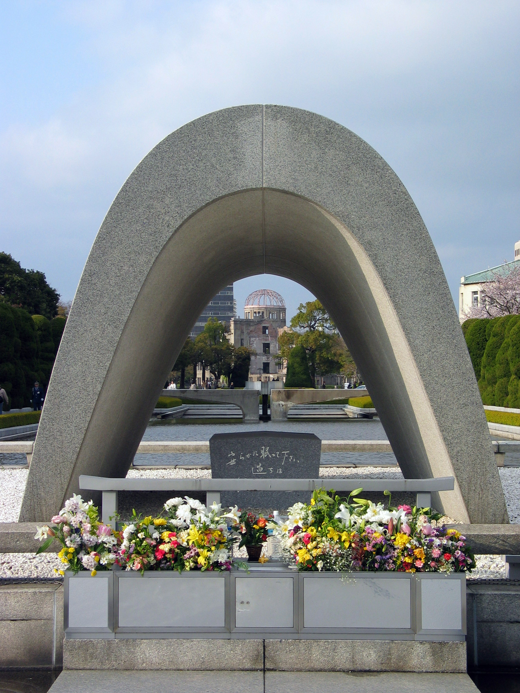
| | | | Other than the bridge, three structures in this area more or less survived the blast, presumably since they were made of stone in an otherwise wooden city, and also since the blast at this point came almost directly from above, rather than from the side, which might have more easily knocked down walls. I first went across Aioi Bridge to the west bank to the Honkawa Elementary School Peace Museum, which I just viewed from the outside. Out of 400 people in the building at the time, only one teacher and one student survived. | | | | I then crossed back over the bridge, avoiding for the moment the ramp to the Park, which I wanted to leave to last, to go to the east bank. My second stop was at what has become the most famous site in Hiroshima, the A-Bomb Dome, seen here looking south from the Aioi Bridge. Right behind it to the southeast is a rebuilt area of the city, only 160 m (525 ft) into which is the hypocenter (the point above which the bomb actually exploded). The Peace Park proper is on the right. Note from here the green roof of the third surviving building, the Hiroshima Rest House in the park, used now as a place to get information and sit down for a while. Although now surrounded by the park, it had been a kimono shop at the time, with buildings and city streets all around it; only someone who had been in the basement survived. It all looks so idyllic.
| | | | After visiting the A-Bomb Dome I went back to the bridge once again and entered the park down that ramp, on the point between the two channels, since I wanted all my perceptions of the area based on the Aioi Bridge. Once in the Peace Park proper, I got a view of the A-Bomb Dome from another angle, and from a distance. I had always thought it had been just some unimportant building, maybe a department store or apartment house, but it seems it had been a landmark. It was built in 1915 by a Czech architect, and in another life was the Industrial Promotion Hall, with its notable green dome, and was an object of local pride. Its dome and skeletal ruins, in which no one survived, have not been reconstructed like the other two surviving buildings, but have been left as a reminder. This building is now a UNESCO World Heritage Site, perhaps the most remarkable one of all. | | | | The Hiroshima Peace Memorial Park was once the city’s busiest downtown residential and commercial district. It was purposely not rebuilt and the open field remaining then was developed into the park. A map in the park shows where streets used to be, and at one point there’s the base of a gravestone from 1689 that had been located in a temple at that point. Other than the three buildings mentioned, among the grass and trees today are only memorials and commemorative buildings. Near the Dome is a memorial to students who were mobilized for the war effort and became victims. In the park proper are the Children’s Peace Monument; the monument to conscripted Korean Victims, who constituted 10% of the dead; and the Memorial Mound, where cremated ashes as well as unidentified and/or unclaimed victims were buried. There is also the Peace Memorial Hall, where, among other things, there is an ever-changing wall of digital photographs of victims with identifying information, as well as a library where further research can be done. In the very center of the circular Hall is a small fountain of white stone. It’s about the size of a low, round table, but its surface has a higher and lower level, which meet at a bent line indicating the blast time of 8:15. In the Peace Memorial Museum it explains that temperatures of 3000-4000° C (5400-7200° F) were reached, and the blast blew at 400 m/sec (984 mph). It is estimated that 140,000 died. One museum display shows a stone step with a dark area in the center and light areas to the sides. Someone had been sitting on the steps of a bank, waiting for it to open; the blast bleached the stone’s color except for where the victim had been sitting. The museum also explains that Hiroshima was a military command center and supply base, and that Mitsubishi, who produced warships, was based here. As an additional thought, note that by 1961 the Soviet Union tested an H-Bomb that was 3300 times more powerful than this blast. | | | | I want to illustrate just two other memorials. As you may know, a cenotaph is a monument that does not include an actual tomb. The Hiroshima Memorial Cenotaph is saddle-shaped, and surrounds a stone box that contains the names of all known victims. This view looks across a pond that includes an eternal flame (not visible in the daylight of this photo) and shows its alignment with the A-Bomb Dome.
| | | | Finally, there’s the Hiroshima Peace Bell. The bell is in the traditional Japanese shape, and as is usual, doesn’t have a clapper. Instead, as was shown in the bell tower in Horyu-ji, it has an external pole hanging by ropes, that is swung to hit the bell. Most people step up to ring it, as I did.
| | | | Hiroshima is the last major Japanese city with trams. As they had crossed the Aioi Bridge in the past, they still do. As a matter of fact, after the blast the tram system was one of the major ways relief was transported around the city. At the station there was a clear display as to how you use the trams, entering in the center and leaving at the front to pay the driver at the end of the ride. I hadn’t taken the trip out to the Park by tram, as most do, since I wanted to approach the park in a way that was meaningful to me, but was glad to take the tram back. The trams run on the left, and the doors are on the left, with the driver on the right. The ride also shows the modernity of contemporary Hiroshima.
| | | | There were a number of restaurants in the hotel, and one of them served tappanyaki, which I wanted to try. This is really less Japanese and more American. During the occupation of Japan after the war, Americans introduced grilling as a form of cooking, and also further popularized the eating of beef. A Tokyo chain established what became to be known as a “Japanese steakhouse”, which spread internationally. When it spread, theatrics were introduced, such as having the chef, while grilling in front of you, tossing knives around and making a big deal of slicing an onion. But my experience with tappanyaki was much more mundane. The chef grilled some beef, chicken, and vegetables as I sat at the combination counter-grill, and the result was OK, but no big deal. Grilled steak is grilled steak.
| | | | But I had a much better dining experience along with that. When I had earlier checked out the menu outside the restaurant, so much of it was dedicated to okonomiyaki, so I looked it up, and that became the culinary highlight of my visit to Hiroshima. It seems there are two versions, Osaka’s and Hiroshima’s. I saw the Osaka one being served, where all the ingredients were combined, sort of like a round omlet, but the Hiroshima one, where the ingredients were layered, seemed more interesting, and, as I’ve said before, when in Rome …
| | | | At dinner that evening I took the combination special, which included a small serving of teppanyaki, an okonomiyaki (which they enjoyed calling a Hiroshima yaki), a beer, green tea, and ice cream for dessert. It was both a bargain, and a pleasure to eat.
| | | | The chef, in front of you, expertly makes two thin plate-sized savory crepes, while on the side, a huge pile of cabbage and sprouts cooks down to a compact size. He adds some pork to the vegetable pile, usually in the form of a couple of bacon strips, and has also been frying up a pile of soba noodles. All of this ends up between the two pancakes. Then he breaks an egg on the grill, swishes it around to the same plate-sized circle, and expertly lifts everything onto the thin, frying egg mixture, so that it adheres to one of the pancakes. It is amazing how he keeps the pile together in one piece, by using two large square-fronted trowels. | | | | He serves it to you, and you have your own mini-trowel to cut off a section, move it to your plate, add a thick sauce that seems to be thickened soy, add pepper and paprika flakes, and enjoy. Here’s a picture of an okonomiyaki chef making about ten Hiroshima yakis at once. Note the squared-off trowel in his left hand, the pile of cabbage and sprouts waiting to cook down, the bottle of dark-brown thickened soy sauce next to the customer, and, of course, the fact that both customers are using chopsticks. It’s really the only way.
| | | | I liked the layering, and don’t see how the mixed-together Osaka version can be as good. And who thought cabbage could be made into so good a dish? I told them I’d be back for the same combination meal the next night, my last in Hiroshima and Japan. I also met a guy next to me who spoke perfect English, but who turned out to be from Wiesbaden. I said I’d studied in Mainz across the Rhine and shifted the conversation to German; he was the one who told me he always enjoys coming back to Hiroshima on business because it’s such a nice place.
| | | | That night I found that the garment the hotel always supplies was more kimono-like as it was back in Nikko, so I wrapped it and its purple obi around me and enjoyed working in my room.
| | | | Day 23: Miyajima Visitors to Hiroshima usually find it worthwhile to also visit the nearby island of Miyajima in the Seto Inland Sea. It’s so popular that there’s even a boat going there that leaves from the Peace Park, and one streetcar line ends down the coast at the ferry to the island. But Japan Rail has a suburban service that gets you to the ferry from downtown Hiroshima in 20-25 minutes, and, that being included in the rail pass, makes it the way to go. The train follows the coastline to the southwest of Hiroshima, and it’s a five-minute walk from the station to the ferry dock to what is the westernmost island in the Inland Sea. There is both a private ferry and a Japan Rail ferry (the only ferry it runs), so even the ten-minute ferry crossing to the looming island immediately offshore is included in the pass. | | | | Even from the ferry, one of the most famous sights in all of Japan is immediately visible, the signature Torii of Itsukushima Shrine. This torii is so unique because it’s in the water—but then, so is the rest of the shrine. The 1875 vermilion torii, made out of camphor wood, is large and looming as it seems to rise out of the sea. It weighs 60 (metric) tons (66 US tons), is 16.6 m (54.5 ft) high, and the roof beam is 24.2 m (79.4 ft) long. Of course it rises out of the sea only at high tide, which I was lucky enough to encounter. Later in the day I saw it rise majestically instead out of the less idyllic mud flats, but that allowed some people to walk up to it. In any case, note in the background the height of the mountains on the island, so that not only does the torii loom on its level, but the whole island looms on a higher level from the shore and from the ferry.
| | | | The ferry terminal is a pleasant ten-minute walk to the shrine. Going I walked along the shore promenade, and returned one block inland through the main street with its shops, which are not overly touristy, but rather pleasant to check out. Also, Miyajima is known for two animals, and the first one was all over the place. Just as in Nara near the shrine area, in Miyajima as well, those little deer walk all around town.
| | | | You can view the torii from the promenade, and then pay the fee to visit Itsukushima Shrine itself. It, too, is over the water, being built on pilings like a dock. I didn’t find any main central shrine, as one often encounters. Rather the dock-type covered walkway, visible towards the left through the building, rambles on for 280 m (919 ft), connecting some 20 one-story buildings such as the one shown here. Actually, the tide was just starting to go out, so some of the buildings were still over water, and others over mud. The shrine dates from 593, but was remodeled as you see it today in 1168, and is a UNESCO World Heritage Site. It was here that I learned that the vermilion color so popular in shrines such as this was originally used to keep evil spirits away. Also, almost next door was another five-story pagoda dating from 1402 and 28 m (92 ft) high.
| | | | Given the height of the mountains on the island with their views of the Inland Sea, and given that the mountains are famous for the fall colors of their maple trees, the other thing to do on Miyajima is to take the cable car up to the top of Mount Misen. I was saved the walk to the lower station by being able to catch the free shuttle bus (coming back the timing was wrong, so I walked, but that was downhill). It was only about a five-minute ride, but on the bus I had my second conversation with a Japanese other than with the guy on the Tokyo metro. I always like to feel I blend in to the crowd, but I do suppose Westerners do stand out among the Japanese more than we realize, especially in off-season. As I think about it, I suppose there were hardly any Westerners around. Anyway, this Japanese guy sitting next to me on the bus started a brief conversation in manageable English and asked where I’d been in Japan. When I told him I’d just left Kurashiki, he was delighted, since that was where he was from. He then asked me if I’d visited the historic Ohara House, and both of us were then delighted when I was able to say that I recently had. (That’s an Americanism; to use the equivalent Briticism [see below], I’d have written “…that I recently had done.”)
| | | | In Japan, they consistently use the word “ropeway” as the English translation of what I was about to ride. I would call it a cable car, but again, that word unfortunately has two meanings—this type, where a cabin hangs from a cable, and also the type where a cable is below in the street, like in San Francisco. I’ve looked the word up, and it’s a viable word in English to refer to an aerial lift such as this, but I don’t know how often it’s really used among English speakers. Anyway, I’ll use it here. The ropeway was a double system, just as I’d come down on from Mount Pilatus in Luzern last summer. The lower section carried a series of
small cabins for 4-5 people. Note several things here. In the left background you see how close Miyajima is to the shore from where the ferry leaves. In the right background is Hiroshima. Below all the trees are green, but in autumn, I found that mixed in with the green were individual trees of blue-red, purple-red, orange-red, deep red, maroon, orange, and more. Finally is one thing I never encountered before. The system runs on the left. I’ve never taken a ropeway before in a country where you drive on the left, and found it startling when I got in and it started to move. In this picture, the cabins on the left are going away from you and those on the right are coming toward you.
| | | | You then transferred at a station to a larger gondola that held maybe 20, and that one worked like a hanging funicular—one went in each direction and they counterbalanced each other. On arrival at the top, you had a pretty good view from the area of the cable house at 430m (1411 ft), but had been told in advance that the best view was from the top of Mount Misen itself at 535 m (1755 ft), about a 30-minute walk, from one rise over and up to another. It was explained that the walk was through primeval forest, and that one should be careful that the monkeys inhabiting the forest (HA!—they must be invisible) don’t snatch any of your possessions. As a matter of fact, free lockers were provided at the cable house to store possessions you wanted to keep away from the monkeys.
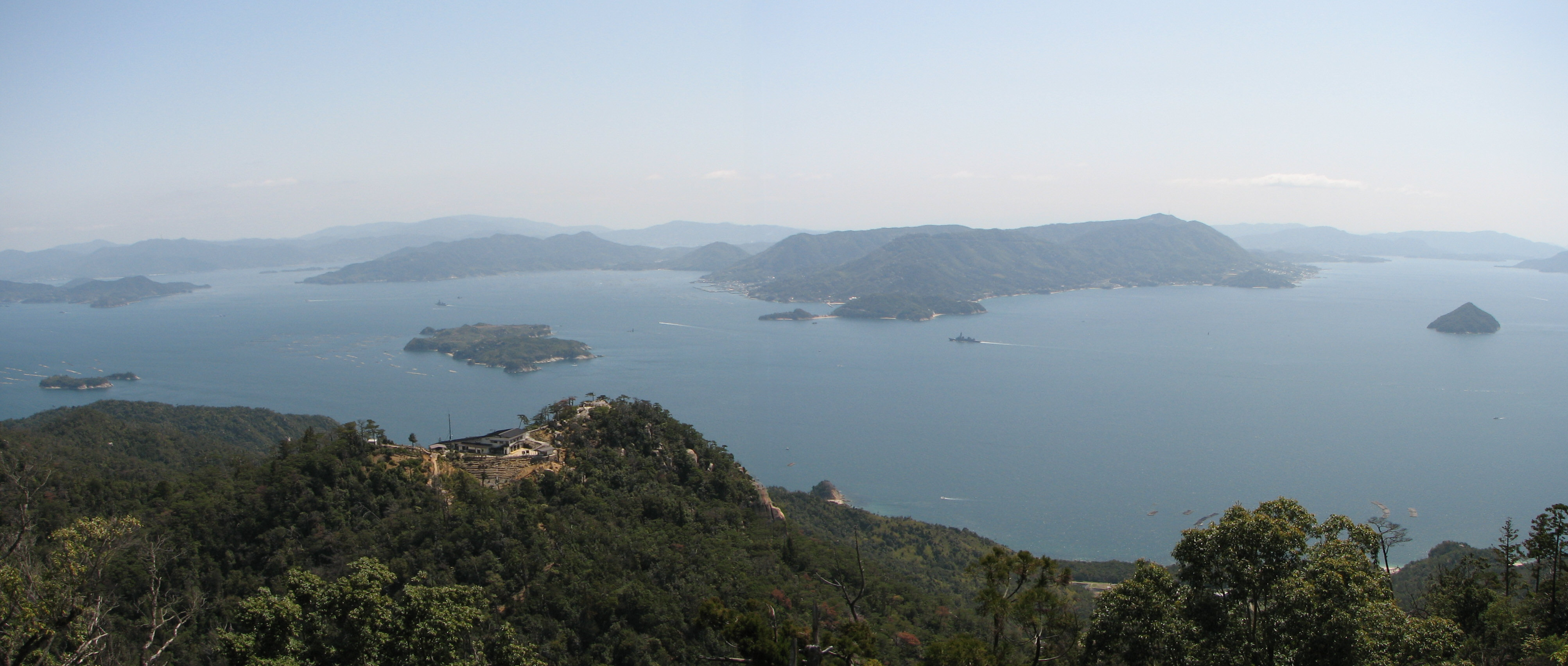
| | | | What to do, what to do. It was just a few steps over to the lower viewpoint visible here to the right of the cable house. You could see the closer islands, as well as back to Hiroshima, but it was the distant islands in the Inland Sea and the hills on the horizon that were so special. I’d seen something similar from the Great Seto Bridge crossing the Inland Sea a few days earlier to Shikoku. The distant islands seemed so misty, so ethereal. | | | | It had been a very good day, but it was while standing at this railing, looking at the view, that the whole day changed for the better. Someone to my left commented on the view, I described it again as ethereal, a word he appreciated, and a companionship for the rest of the day, through dinner, developed. I’ll say again that there were very few Westerners traveling the area, and this one turned out to be Andy Clarke, formerly of the London area, now from North Wales. It even turned out we were staying at the same hotel. A discussion ensued, and it turns out he’s a web designer of note who has written several books, has several websites, and regularly has speaking engagements on his topic. He had just been on a professional visit to Tokyo, and, as fate would have it, chose Hiroshima and Miyajima for a two-day side trip before returning to the UK. He’d also been a professional photographer, and was shooting constantly the whole afternoon. Even if I didn’t know his photography background I could suspect the quality of his work by his careful choice of subject matter, often including just details, as compared to the tourists who so boringly plop themselves in every view they take.
| | | | He told me that evening after he’d called his wife that she’d commented that he never meets people while traveling/travelling, but we just hit it off. Each seemed to enjoy what the other had to say. Andy enjoyed my use of the word “ethereal”. I enjoyed his use of a New York Yiddishism when he talked about shlepping further up the mountain. He’d had plenty of experience in the US, having driven with his wife and teenage son from San Francisco throughout the Rockies to Minneapolis. I told him about my UK experiences, and he enjoyed using Americanisms (cookies), while I enjoyed using Briticisms (schedule=shedule).
| | | | Most of this palaver didn’t happen at the railing, but en route. I’d wondered out loud about going all the way to the upper level; he’d commented that it would be the thing to do having come this far, and thus began the epic called “Laurel and Hardy Climb a Mountain”, with Andy playing Stan and me playing Ollie. It turned out to be a successful and fulfilling accomplishment, although each of us pointed fingers at the other for having gotten us into it in the first place! | | | | On the other hand, it was like my mountain-climbing story (2009/31) coming to life. I indicated to Andy on signs along the way two of the fundamental characters we’d written about, 人 and 山. So I suppose you could say that Andy (人¹) and I (人²) decided to go 上 the side of a 山 through the 中 of a primeval 森. We were having a great conversation, but had to keep on pausing to 休, since we both admitted that we tend to be sedentary in front of a computer. But neither 人¹ nor 人² relented. It was not a macho thing. It was a matter of just wanting to make it to the 末. | | | | We finally reached a tiny plateau that had three medium-sized shrines around it. We were only about ¾ of the way up, but had thought we’d reached the 末, so 人² jumped up on a boulder in a Ta-DA! stance, which the ever-ready photography whiz, 人¹, immediately recorded for posterity. Other than on the home page, this is the only picture of 人² on the website, and it’s only because 人¹ posts his photography work on Flickr under Creative Commons usage rights, and showed 人² how to access it.
| | | | But after visiting the shrines we noticed that the view wasn’t all that good—and人² wondered what that staircase up to another shrine was doing there. So on and on we went. Then we again seemed to be at the 末 until 人¹ discovered a few more steps behind a boulder. Finally, we made it to the very 末—really--and 人¹ went on a picture-taking spree, until 人² took note of the two-story/storey metal viewing platform, scrambled up to the top of it, and then goaded 人¹ to follow those last few steps. Finally, Laurel and Hardy were at the very 末 of Mount Misen and had close to a 365° view from its 535 m (1755 ft). We had climbed 105 m (344 ft) above the cable house here in the picture, while walking between summits. Although Hiroshima is not visible here (it would be to the left), you do see just a bit of the ethereal quality of the distant islands in the Inland Sea and of the horizon.
| | | | At this point I took his camera to take a picture of Andy Clarke, the Pensive Sage of Mount Misen, at its real summit, with Hiroshima visible to the right.
| | | | I’d originally thought I’d be back in Hiroshima by mid-afternoon so hadn’t paid that much attention to the fact that the ropeway closes at 17:30 (5:30 PM), but with all this activity it was already late afternoon, so we then scrambled back down to the cable house, making the 16:30 departure, but even that early there weren’t that many people left up top. And we didn’t see a single monkey the whole time during the 三 hours we were up top between ropeway rides.
| | | | After a last look around in town down below, we caught the ferry, then the train back to Hiroshima to our hotel. Andy had already tried an okonomiyaki in town the day before, and when I said I was going back to the special restaurant in the hotel that served the combination teriyaki and Hiroshima yaki, he was interested in joining me, so after a rest, we went to dinner together. It was the end of a very pleasant last full day in Japan for me.
| | | | Day 24 (First Half): Fukuoka/Hakata My last half-day in Japan turned out to be drizzly, so we’d been lucky with the two nice days in Hiroshima and Miyajima. Andy took the train to Tokyo for a night there before flying back to the UK, and I took my last Shinkansen ride (sob!) from Hiroshima to what’s listed in the rail schedule (shedule?) as Hakata. There were enough tunnels so that I really couldn’t tell which tunnel got us under the strait between Honshu and Kyushu, the last of the four main islands I set foot on. | | | | Kyushu’s main city is called Fukuoka, and it was from Fukuoka airport that I’d be taking my flight to Taiwan. So why did I go to Hakata? Therein lies a tale.
| | | | Japan is very good at consolidating municipal areas. Following regional growth, surrounding towns are constantly becoming parts of larger cities. Even the town of Miyajima just a couple of years ago officially became a suburb of the nearby city on the mainland. | | | | In northern Kyushu there was a pair of twin towns that were due to be consolidated in 1889. Fukuoka lay west of the river, and Hakata east. Fukuoka was largely residential, and included a large number of old samurai families. Hakata was the merchant town, with the main commercial center, was more associated with culture, and included the port. Both towns had—and have—rail stations named after them, but Hakata’s was—and is—more accessible to the national network. The town council decided therefore to name the combined city Hakata. But as that decision was being made in 1889, a group of samurai crashed the meeting and forced those present to choose the name Fukuoka.
| | | | To this day, Hakata remains the main commercial center of the combined “Fukuoka”. Its well-located rail station is the main station for “Fukuoka” even as a Fukuoka station exists over in that part of the combined town. The Hakata station is even the last stop on the Shinkansen line, not only from Osaka, but all the way from Tokyo. Therefore, you have to know that to go to “Fukuoka” you have to go to the Hakata station.
| | | | Then the airport was built near Hakata station, and on the far side from old Fukuoka no less. So to fly from “Fukuoka” you still go to Hakata station. Clear? This sort of confusion sounds so un-Japanese. After all this time, couldn’t they finally rename the whole city Hakata?
| | | | This city probably has the best airport connections in the world from a main station, since the two are so close. The modern subway has a line that goes under Hakata station, makes one intermediate stop, then stops at the airport. It’s about a 5-6 minute ride, which is incredibly convenient. Also incredible is the modern computer world, which allowed me, before leaving home, to check the airport and see that the subway leaves you off at one of the domestic terminals, but that a free shuttle bus takes you to the international terminal. All this knowledge makes things so easy. Also, when leaving a country, one tries to get rid of local cash by using it up on the last hotel bill, then paying the balance on a credit card. But I needed to know the subway fare right at the end. It was so easy to find the proper website that told me I’d need to keep ¥ 250 aside for that final expense on the metro to the airport. And don’t giggle too hard when you hear that the code for Fukuoka airport is FUK.
| | | | The flight to Taipei was about three hours, but Taiwan is one time zone earlier, so I gained an hour, but I’d pay for it later. I flew EVA Air, which is Taiwan’s #2 airline, and this was the only flight I paid for on this trip, since the rest was on points, as was the Sheraton hotel I stayed at in Taipei. As for the Travelers Century Club, Japan for me was # 123 and Taiwan # 124. | | | |
| |
|
|
|

