|
Reflections 2011
Series 20
August 24
New England Thrice-2B: Salem - Saugus
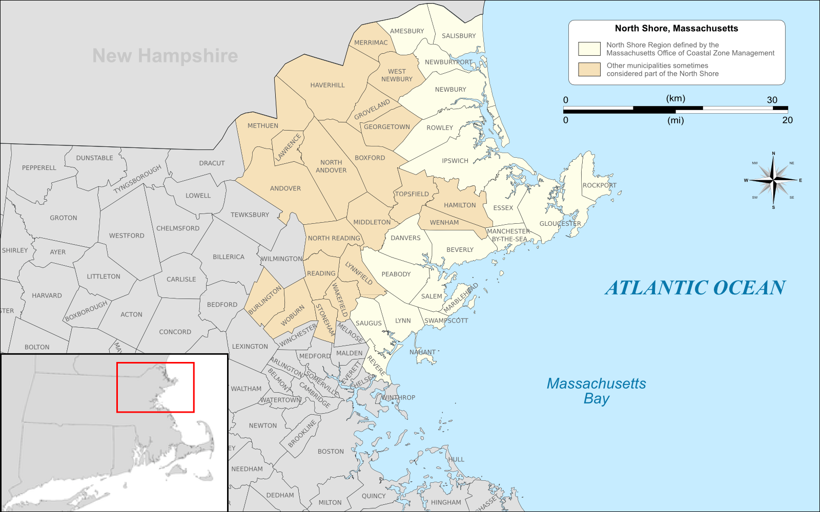
| | On this second of three New England trips this summer (this second trip covering four postings) I’d come into Boston’s South Station on Amtrak, used my Charlie Card to take two short subway rides to North Station, and bought from the automatic machines the three round-trip commuter rail tickets I’d need, at half price for seniors. It was only late afternoon, and I was still able to catch the 5:25 commuter express that had Salem as its first stop. Between one New York subway, three LIRR trains, one taxi, one ferry, one Amtrak train, two Boston subways, and this Boston commuter train, I’d had a total of a ten-seat trip from home in Manhattan to my hotel in Salem. It was fun in planning and fun in executing. | | | | Salem We have to reëstablish in our minds the significance of Salem, as well as its location. We last discussed this in 2009/25 with this map of Two Bays & Two Capes. Cape Cod surrounds Cape Cod Bay and was the location of the first settlements in this area, in the Plymouth Colony of 1620. But protruding northeast from Boston is Cape Ann, encompassing Massachusetts Bay, and the area between Boston and Cape Ann is the North Shore. In time, settlement momentum in the area moved away from the Plymouth area and to here instead, mostly of Puritans arriving in the late 1620’s in the Massachusetts Bay Colony. This colony was centered around Salem (1626) and Boston (1630), and gained significance to the point where the charter for Plymouth Colony was revoked in 1684, and the name of Massachusetts Bay Colony eventually coming down as the name of the State of Massachusetts, not the State of Plymouth. Salem is located halfway between Boston and the end of the cape (click to enlarge above map). The big peninsula you see is Marblehead, and the inner peninsula, with the protected harbor, is Salem. Given this background, Salem has similar historical gravitas to Boston, even though Boston became the capital. | | | | This map shows the towns on the North Shore (click to enlarge). Locate Marblehead, protecting Salem’s harbor. To the SW is Saugus, which we’ll visit and discuss later, and further still is Boston. To the W you will find later stops on this trip, both Lexington and Concord, with Sudbury being hidden behind the inset map. | | | | Salem stands out because of two periods of history. Given the date of the settlements, primary is the last eight decades of the 17C, with numerous reminders still visible and visitable. One doesn’t have to look far to find evidence of the 1600’s in Salem, or in all of coastal Massachusetts, for that matter. But also very important is the last quarter of the 18C, and its maritime tradition. In the late 1700’s, Salem reached an importance to the point that some people around the world thought Salem was a country, not a city. | | | | ARRIVAL I’ll describe my first impressions of arriving in Salem on this trip, the evening of the travel day as well as the first full day, in order to present the city as one sees it. But then I want to deconstruct the visit into time periods, by century. The train arrives in Salem from the S by entering a short tunnel under the city center and emerging to the N, where the outdoor station is immediately beyond the tunnel portal. A staircase brings one up to street level, where a short walk south on Washington Street brings one to Essex Street, which runs east-west through the city. However, turning east, those first several blocks are a pedestrian mall, giving one a pleasant introduction to town. At the end is the Hawthorne Hotel, abutting Hawthorne Boulevard, with a statue of the author, and on the other side, Washington Square, which is historically Salem Common, and is a pleasant park in an odd, quadrilateral shape, a layout resembling a fan. The Hawthorne Hotel is a member of Historic Hotels of America, which might imply more age than it has. It was built in 1925 in the same Federal style as the houses surrounding Washington Square, but its size makes it stand out. It has a cozy, period lobby, and lots of pictures and notices explaining its history. I remember a picture of opening day, with a large crowd standing outside, mostly of men in straw hats. The few women wore cloche hats. One of the notices was an interview with a man who had been a bellhop in the hotel’s early years. Bellhops worked rotating shifts in a six-day week, took turns running the elevator, and earned $5 a week plus tips. He remembers the hotel doing good business until the 1929 crash. In those lean years, he once lost $170 of the hotel’s money returning from the bank in 1936, but the hotel trusted him and kept him on. Some eight months later, a woman who had found the money on her way to an extensive tour in Europe, finally came back and returned the money, vindicating the bellhop. This sort of story endears one to the building. However, in the growing “car years” of the 1950’s, the hotel panicked, bought and tore down some houses behind it for a parking lot, and actually became the “Hawthorne Motor Inn”. It eventually came to its senses. While it was newer than the two 18C hotels I stayed in afterward, it was a good witness to the 20C. | | | | A few blocks down Hawthorne Boulevard I’d found an interesting restaurant in Zagat, and liked it so much I went two nights. Zagat lists The Grapevine as “the North Shore’s best restaurant”, and I can believe it. I spoke to some regulars who swear by it. Zagat rates its food 27 (out of 30), and its prices are very reasonable. Most memorable was an appetizer of four fresh figs filled with blue cheese, wrapped in bacon, and roasted. | | | | Take a look at this aerial view of Salem. Top center is the Hawthorne Hotel (and parking lot), with Washington Park fanning out beyond. On its near side, Essex Street runs the entire length of the picture, but the hotel faces the few blocks of the pedestrian mall. Hawthorne Boulevard comes down past that red church to a plaza; continuing straight is The Grapevine; to the left of the plaza, the greensward is the Burying Point, a cemetery we’ll discuss later; to the right of the plaza, Derby Street leads into the Salem Maritime National Historic Site, with former piers leading out into the harbor, and historic buildings across Derby Street; just off the right of the lower right-hand corner of the picture stands the House of the Seven Gables. | | | | The entire week I was there, there was a heat wave. In Salem it seemed to center at about 95°F (35°C) and in Lexington and Concord later on it might have reached about 104°F (40°C). Still with frequent stops in the shade, and sitting down, for that week I was able to do the extensive amount of urban walking I like to do. The full day in Salem I started with the areas around the hotel, then saw the Maritime site quite extensively, plus the House of the Seven Gables. I then walked back down the Essex Street pedestrian zone, which included a number of historic houses, visited the cemetery, then went beyond the left side of the picture to review the houses in the McIntire Historic District. The only other time I’d been to the areas I’d be visiting this week was in 1969, when on our whirlwind tour around the East, we stopped at Concord, Lexington, and Salem all in one day. This time was an opportunity for more depth, especially since Salem, with its historic districts, is noted for architecture covering three centuries, 1640-1940. By the way, the name Salem is derived from the Hebrew word for “peace”, shalom. This is equally true of any town called Salem, and the word appears as well as part of the name Jerusalem. | | | | EUROPEAN 17C IN AMERICA My intent under this topic is to discuss the fabulous wealth of surviving 17C structures in Salem and in eastern Massachusetts in general, but when talking about 17C Salem, we cannot ignore the elephant in the living room, the Salem witch trials. | | | | Salem Witch Trials I have no intention of presenting in detail what caused the hysteria in Salem that resulted in this travesty of justice in 1692. Yet lest the reader think that such travesty was home-grown American, the reason I include it under European 17C in America is because what happened in Salem was a reflection of what had been happening all across Europe. Witch hunts and trials as we picture them occurred earlier (France, Switzerland), but then went into a decline. They then became a major issue again and peaked in 1580-1630 (Germany, Scotland). German astronomer Johannes Kepler in 1615 could only keep his mother from being burned as a witch because of the weight of his prestige. The hunts and trials declined again after 1650, although still occurring (Sweden, Austria). Then, as the practice was waning in Europe, the practice flared up in the distant colonies in Salem in 1692. However, it must be noted that the Salem case was not unique in Western culture, and reflected a negative “inheritance” from Europe. Still, Salem stands out as the place to remember in this regard. Say “witch” in the US and one thinks of Salem. I know of no European city that had witch trials where anything similar occurs. The “witch” image has become part of Salem’s cultural identity, for better or, as I believe, for worse. | | | | All cultures have iconic figures: the soldier, the cowboy, the firefighter, the nurse. There are even some historic ones: the woodsman, the blacksmith. Ask any child to draw a policeman, and the stereotypical, iconic image will appear. Two other iconic figures are the pirate and the witch. Both are grossly trivialized from reality. The pirate, in 19C costume, with eyepatch, parrot, and “aargh”, is very different from the Somali pirates recently attaching shipping in the Indian Ocean. Why name sports teams Pirates (or Buccaneers)? The witch, too, is standardized: always a woman (also referred to as the “old hag” figure) in black, with pointed black hat and broom. How do you compare that with the people that were persecuted for “casting spells”? Salem lives hovering between the two worlds of maintaining the iconic symbol of the witch balanced against the witchcraft trials and executions of 1692. | | | | Salem uses the nickname “Witch City”, and its police cars show a silhouette of a flying witch as a logo. There is a Witchcraft Heights Elementary School, and school athletic teams are called the Witches. I understand it’s almost impossible to get a hotel room in Salem at Halloween. Well, a buck is a buck. But it goes too far. Just walking along the pleasant, historic, pedestrian mall part of Essex Street I wrote down a list of actual businesses (I also got some off a map). Interspersed with fortune tellers and other off-the-wall boutiques are these actual ones: Bewitched in Salem; Witch History Museum; Witch Dungeon Museum (why Dungeon?); Witch City Ink, World Class Tattoos (picture what pictures they specialize in); Spellbound Tours; Haunted Footsteps (why Haunted?); Nightmare Factory (Oh, come on!); New England Pirate Museum (!!!); Vampire and Ghost Hunt Tour (!!!). I give up. | | | | But the actual events are much more serious and somber, and involve mass hysteria, religious extremism, false accusations, lapses in due process and intrusion of individual liberties. Given all this, the two most heartening events in my mind occurred in 1992 on the 300th anniversary of the 1692 trials. That year, the Massachusetts House of Representatives was persuaded to issue a resolution honoring the victims, and when it was finally signed by the Governor on 31 October 2001, all were finally proclaimed innocent. I do not know why it took so long to get signed, however, and it does bother me that it was signed on Halloween, which is a bit tacky, given the serious subject matter. But that’s Salem. | | | | The other heartening event in 1992 was the dedication of a small memorial park in Salem to honor the victims three centuries earlier. Particularly of interest were two of the speakers at the event. One was Nobel Laureate and Holocaust survivor Elie Wiesel. I’m sure his presence drew a parallel between his personal experiences and the mini-Holocaust that occurred in Salem. Another speaker was author Arthur Miller, who wrote his play The Crucible based on the trials, in which he likened the trials to the intrusive investigations of the House Un-American Activities Committee. I’m sure both speakers drew parallels between these events of governments turning on their own citizens.
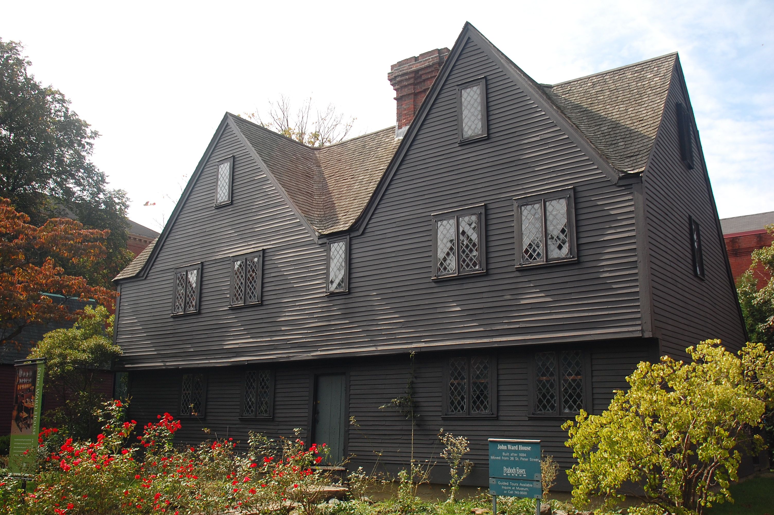
| | | | I visited the memorial in connection with visiting the cemetery with the unusual name of Burying Point, mentioned above, where I couldn’t find the oldest grave, dated 1673, but did find the grave of Salem Architect Samuel McIntire (died 1811), discussed later. I was also unaware at the time that Nathanial Hawthorne’s ancestor, John Hathorne (spelled that way, without a W) who was a witch trial judge, was also buried there (although I probably wouldn’t have found the grave anyway, since I didn’t have a map). Adjacent to both the memorial and cemetery, and lending additional 17C cachet, is the Pickman House, circa 1664, shown here in part, used today for offices of the Historical Society. The house is located on Charter Street, which gives its name to the Charter Street Historic District, which comprises the house, the cemetery, and the memorial, forming a tidy 17C grouping just a block south of Essex Street. | | | | The stone tablet indicating the Salem Witch Trials Memorial says it was dedicated on 5 August 1992 to commemorate the tricentennial period of 1692-1992, and includes the statement that “This memorial is dedicated to the enduring lessons of human rights and tolerance learned from the Salem witch trials of 1692”. | | | | Carved in large paving stones were poignant direct trial quotes such as these: | | | | | | I am wholly innocent of such wickedness.
My life lies now in your hands.
If I would confess I should save my life.
I can deny it to my dying day.
I am no witch.
|
| | | | The memorial is actually a medium-sized open courtyard abutting the cemetery. It’s entered by crossing the paving stones with the quotes and is surrounded by thick, low stone walls. Protruding from the wall are 19 slabs, that sort of look like benches. Each slab tells about one of the victims, giving the name and date and method of execution. This brochure page has two pictures of interest. The first one shows a bit of the Burying Point, but more importantly, the second one shows, in front of a full view of the Pickman House, the low wall of the memorial with four (of the nineteen) unusual, and quite distinctive memorial slabs protruding from it (they DO look like benches!). | | | | In total, some 200 men and women were accused of witchcraft, 150 imprisoned, and 19 executed in the 1692 small-scale Holocaust. All but one were hanged; the exception was one man who was pressed to death, as mentioned on his slab. | | | | In the nearby town of Danvers there is today the Rebecca Nurse homestead, which can be visited; I understand it’s a 1678 saltbox. She is the one victim whose name is better known. The dates in 1692 of the executions are, as indicated on the slabs: | | | | | | June 10 - 1 woman
July 19 - 5 women, including Rebecca Nurse
August 19 - 4 men, 1 woman
Sept 19 - 1 man pressed to death
Sept 22 - 6 women, 2 men
|
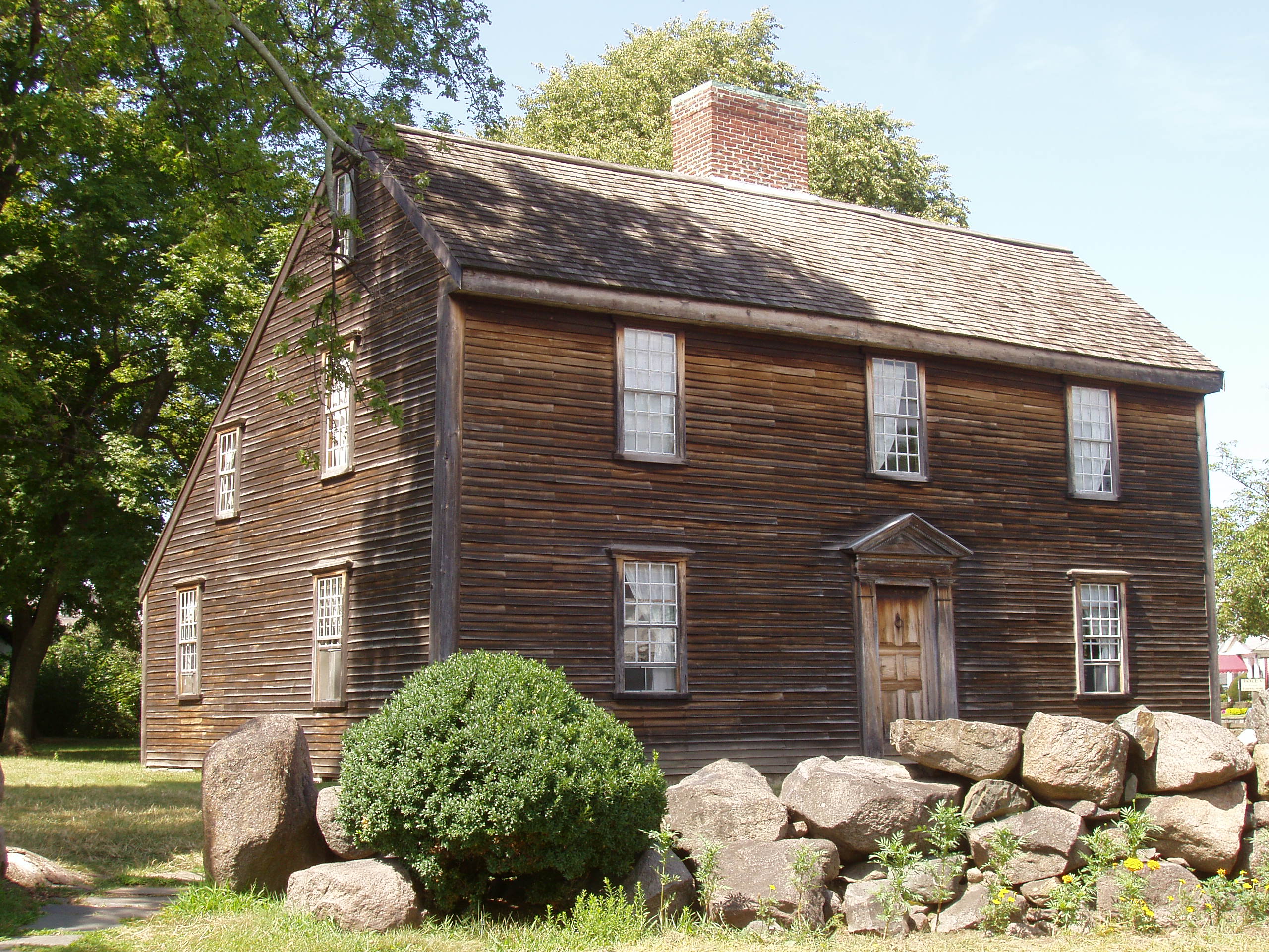
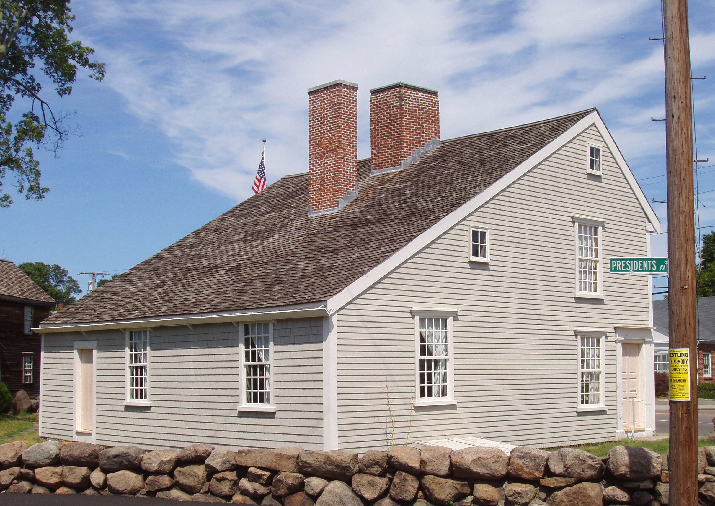
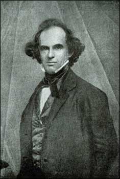
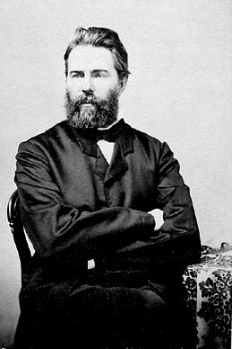
| | | | The total comes to 13 women and 7 men. Two slabs had fresh flowers left on them, including that of Rebecca Nurse. | | | | 17C Structures But the European 17C in America is certainly represented by much more than witch trials and memorials. British settlement of the east coast of North America has left us in Massachusetts the most extensive tangible remainder of its cultural inheritance. I’ve reviewed an incomplete list of over four dozen surviving structures in Massachusetts dating from the 1600’s, the oldest c 1637. We’ll be referring to a number of them here, and have already mentioned the Jethro Coffin (“Oldest”) House and Old Gaol in Nantucket (2011/18). | | | | When describing the Jethro Coffin house as a saltbox, we said we’d have more to say at this point. I’ll use as an example a house I did not visit, can be used for illustrative purposes. Located some 35 driving minutes NE of Salem in Amesbury MA is the Macy-Colby House (1654; rebuilt 1745) (Photo by Daderot). Remember that a saltbox, which takes its name from its resemblance to the wooden lidded box in which salt was once kept, has two stories on the front and one on the back, at the bottom of a long pitched roof. The central chimney is typical, as is the usual flat front, although this one seems to have an add-on entry. It’s the asymmetry of the sides and the long, low rear roof line that are the most distinctive features of a saltbox. The saltbox, probably popular because of the simplicity of its design, originated in New England, and is an example of American colonial architecture. | | | | While the Jethro Coffin house in Nantucket had weathered cedar shingles on its walls, clapboards, as seen here, are also typical in New England architecture. A clapboard is simply a board used for horizontal siding that has one edge thicker than the other, so that an upper one can lap over a lower one. In Australia and New Zealand, clapboard is known as weatherboard. | | | | Two more eastern Massachusetts saltboxes that are not in Salem but that I did visit years ago are south of Boston in Quincy (pronounced locally Quinzy). They are the adjacent birthplaces of the second president, John Adams, and his son, the sixth president John Quincy Adams (yes, he should officially be pronounced Quinzy, too). While both men were born in the 18C (1735 and 1767), they were both born in saltboxes built in the previous century. The John Adams birthplace was built in 1681 on a 1650 foundation. It has all the hallmarks we discussed, (weathered) clapboard, central chimney, asymmetrical sides, but includes the more typical symmetrical front. Steps away is the John Quincy Adams birthplace built on a 1663 foundation, but in 1716. It’s different to see the rear view, and also to note that weathered siding wasn’t essential in the colonial period. | | | | Typical as saltboxes are, I didn’t see in Salem any of exactly that style, but instead what seemed to be variations on a theme. Just off Essex Street is the John Ward House (click to enlarge to inspect detail), built nearby in 1684, but moved to museum grounds in 1910. It looks like the house wants to be a saltbox. We see much of what we expect: dark clapboard siding, central chimney, two stories in the front, one in the back. But in a city where we know there’s a famous house with seven gables, what do we see that’s strikingly new? Two large gables defining the front, which is otherwise quite symmetrical. Gables are one of several elements we notice that start to give these structures even more of a dark, brooding, wintery, medieval aspect. Another innovation is the projection of the upper storey out over the lower one, something that one expects to find in medieval cities in Britain and Germany. Finally, we see another typical element, the small casement window, which, as opposed to a sash window, is attached to its frame by hinges at the side. They can be used, as shown here, in pairs within a common frame or singly. In French they are called fenêtres à la française (“French-style windows”), in German, Flügelfenster (“wing windows”). As is often the case, the German name describes most accurately what the windows actually look like. | | | | Down on the east end of Essex Street and included in the Maritime NHS of later date, is the Narbonne House of 1675 (here a rear view), showing a more atypical shape and color scheme. | | | | A particularly nice specimen of the style is the Jonathan Corwin House. Unfortunately, this house most frequently goes under the unfortunate name of the Witch House, since Jonathan Corwin was one of the judges at the trials, and some of the trials were held in this house. It is therefore the only building still standing associated with them. However, what I read is that the house mostly illustrates 17C life in Salem generally, as it should. In any case, this is the front view of the Corwin House. As to its date, Judge Corwin purchased it in 1675, and that is the only date associated with it that can be substantiated, but most historians believe it dates from the 1660’s or early 1670’s, and can be marked c 1660-70. | | | | Comparing the Corwin House with the Ward House, Ward’s simpler two gables compare here not only with three, but with the center one protruding substantially. Ward has one overhang, but Corwin has two. In addition, the lower overhang has four teardrop pendants under it at the four front corners, two of them visible here. All this underscores its somber medieval character. Much more can be seen in this side view, which unfortunately includes a bright red restoration sign, but which otherwise profiles the front, the overhangs, and the pendants nicely. It also shows what I feel is typical, a lean-to added in the back in historic times, clearly with a varying roof line, but perhaps attempting to evoke a saltbox. | | | | But the most famous of these 17C Salem houses is of course the House of the Seven Gables, because of Nathaniel Hawthorne’s novel of the same name. It is also known as the Turner House, and its date of 1668 makes it the oldest of the 17C Salem houses that can be substantiated. | | | | Nathaniel Hawthorne was born in Salem (and is buried in Concord--I saw his grave later in the week), as evidenced by the Hawthorne Hotel and the adjacent Hawthorne Boulevard, whose park includes this statue of Hawthorne later in life. He was born with the spelling Hathorne, like his great-great grandfather John; it was Nathaniel who added the W in his twenties, not only to make it a more sensible spelling, but also to dissociate himself from that past. His Salem origins are evident in much of his writing, which centers on New England, or even Salem, with its Puritan history. He was part of the Romantic movement, in the subgenre called dark romanticism, which shows individuals as sinful and prone to self-destruction in a dark, decaying, mysterious world. Hawthorne is one of a triumvirate of American dark romantic writers along with Poe and Melville. He had worked earlier at the Boston Custom House in 1839-40, and in 1846 was given an official appointment in the Salem Custom House. But it was a political appointment, and he lost his job after the presidential election of 1848, so he returned to writing and published The Scarlet Letter in 1850, where in the preface he refers to his time in the Custom House. It was an immediate best-seller, and introduced Hester Prynne to the world, one of the first and most important female protagonists in American literature, whose husband is away, but who becomes pregnant. She’s convicted of the crime of adultery and forced to wear a prominent letter A, colored scandalously red, for the rest of her life. (In this regard, I always think of the musical The Music Man, where the womanizer Harold Hill in the song “Sadder but Wiser Girl” says he’s hoping for a woman with a “touch of sin”, and sings “I hope, I pray, for Hester to win just one more A”. Most people are expected to get the reference, and I always have to smile, because it IS funny, but I don’t think Hawthorne saw it in terms of “winning” an A!) | | | | Hawthorne reached the high point of success that year and the following one, 1851, when he published The House of the Seven Gables. This is a daguerreotype of Nathaniel Hawthorne c 1848, three years before writing Gables. The original building (the Turner House) still stands on the harborfront on Turner Street, just a few blocks beyond the Custom House where Hawthorne worked. When John Turner III lost the family fortune, the house was acquired by the Ingersoll family, and Hawthorne, while growing up, was often entertained there by his cousin Susannah Ingersoll, so he was already familiar with the house and its history. He set his novel there sort of as a composite of the house itself and of the Corwin House belonging to his ancestor, since he was still burdened with feelings of guilt going back to his ancestor involvement in the trials. He calls his family Pyncheon, and that family, too, carries a great burden based on the dishonest, amoral way the land under the house had been acquired two centuries earlier. He explores themes of guilt, retribution, and atonement in the novel, both his own and the Pyncheon family’s. | | | | Unfortunately, visiting the house today is akin to visiting Disney World. The entire block is walled in, with the house fortunately being directly on Turner Street at the harbor. I would suggest that only those actually visit its inside who have never seen a 17C interior and/or who are very familiar with the novel, since several locations from the novel are apparently pointed out. Otherwise, the building was run like a tourist mill. One had to buy tickets for half-hour tours in ten-minute increments, with the next tour when I was there starting in ¾ of an hour. One got to see six of the sixteen rooms, but such a setup was not for me. One could eat in the courtyard café (access only by tour ticket), and then be herded through the house. There is a vast difference seeing a monument by yourself, or with few other visitors, and attending this mini-Disney World. I viewed the model of the house in the visitor’s center and looked at two façades facing the courtyard through the visitor center windows. The other two façades I saw from the street, and was more than satisfied, especially having avoided the historical travesty. | | | | This is the House of the Seven Gables from the harborside. If you wondered how a house can have seven gables, so did I, so I checked it out. On the right, facing the harbor, with the two pendants, is the central part of a triple gable, with two others growing out of its sides, the close one visible and the far one hidden from view. Facing the garden (beyond the roof to the entryway) is a fourth gable. Facing the visitor’s center beyond the left chimney is a fifth. And hidden from view facing Turner Street, at the main entrance, is a double gable, its main part facing the street and a second one, growing out of it, facing the harbor. That’s our seven gables. | | | | I therefore visited the exteriors of all five 17C Salem buildings: 7 Gables 1668; Corwin c 1660-70; ; Pickman c 1664; Narbonne 1675; Ward 1684. | | | | [It is too coincidental to avoid bringing up Herman Melville again, especially now that we see that he and Hawthorne fit into the same literary subgenre. Although, because of Moby-Dick, we associate Melville with Nantucket, he was born in New York City, then lived elsewhere, but returned to spend his later years again in New York. The first coincidence was that I’d remembered that Melville also worked in a Custom House in New York, then, with a bit of research, I found more interesting facts. In mid-life Melville moved to a farm near Pittsfield, Massachusetts, in the Berkshire Mountains, where he made the acquaintance of, and befriended, Hawthorne, who had a house in nearby Lenox. Then, not only were Moby-Dick and 7 Gables both published in 1851, Melville actually dedicated Moby-Dick to Hawthorne, since he had been so inspired by him. This is Herman Melville in 1860, nine years after Moby-Dick was published. In later life, the friendship declined, Melville had mental and other health problems, and Melville was completely forgotten by the public for the rest of the 19C. In 1866, Melville’s wife and her relatives used their influence to get him a job as customs inspector in New York, a post he held for 19 years, so, while Hawthorne worked for customs early in life, Melville did so later in life. It was not until the 20C that there was a revival of interest in Herman Melville and his works, which remains to this day.] | | | | MARITIME SALEM While it’s the 17C that really impresses in Salem, there’s a period at the end of the following century that’s of international importance, that of the time when Salem was known around the world for its maritime prowess. On our whirlwind visit to Salem in 1969, that maritime history was something that impressed me quite a bit, since I learned something totally new for me, especially when we visited the Derby House, a mansion of a major ship owner, today in the Salem Maritime National Historic Site. | | | | The film in the visitor’s center showed clearly how it started, and it all started with cod. Cod was plentiful enough that it gave its name to Cape Cod; since cod is central to Portuguese cuisine, the many Portuguese communities in Massachusetts owe their origin to the arrival of Portuguese cod fishermen; the cod is the state fish, and the Sacred Cod of Massachusetts, a pine carving of a codfish 1.5 m (4 ft 11 in) long dating to 1784, hangs in the House of Representatives in the State House. From Salem’s founding in 1626, ships were being built, and by 1643, merchant shipping proved to be more lucrative than fishing. The film in the visitor’s center showed how an overabundance of dried cod led to Salem ships to sail down the coast to trade cod for other goods, then the ships spread to the West Indies to trade for rum and molasses, and the industry grew from there around the world. Over time, almost 1,000 ships were launched out of Salem. Then, during the Revolution, when the ports of Boston and New York were occupied by the British, it was Salem’s ships that carried arms and supplies to colonial troops. As the Continental Army grew out of local militias, the original 25 vessels of the Continental Navy were insufficient, which led to the period of privateering. A privateer is a ship authorized by a government to attack foreign shipping during wartime. Privateering was a way of mobilizing armed ships without having to spend public money, and is particularly useful for a smaller power attacking one dependent on trade, since the larger power has to use navy ships needed for warfare to protect merchant vessels. Privateers had investors wanting a share of the prize money gained from selling the cargoes. It’s been said that privateering was less destructive and wasteful because the goal was to capture ships rather than sink them. Salem’s ships captured about 400 British ships before the war was over. | | | | But then with the experience that Salem captains and merchants gained, after the war they expanded into world trade in merchandise. In 1786, Elias Derby, the leading Salem merchant and shipper, sent his Grand Turk out of Salem, and it returned from China with luxury goods. Two years later, he sent his Peggy to India. This Asian commerce was referred to generally as the “China trade”, and made Salem enormously wealthy. As to the importance of the Custom Houses, note that the taxes (tariffs) paid on imported goods supplied 95% of the US federal budget in 1792, and the port of Salem was a major contributor. Some luxury items stayed in Salem, duties were paid, and the goods entered Salem and the US; others were kept in bond, without paying tariffs, since they weren’t entering the US, and were then transshipped for yet higher profit. Salem mansions were filled with luxury items from around the world. In 1790, Salem was possibly the richest city in the United States, per capita. To this day, Salem’s motto, in Latin, is: Divitis Indiae usque ad ultimum sinum (To the farthest port of the rich Indies), which to me reflects the upbeat outlook of those times. Salem’s ships were so common in ports around the world that many people in those places, when hearing a reference to a Salem ship, thought Salem was some large, magnificent country. | | | | The business was largely barter, but also cash, and a good captain could come back to Salem having doubled, or even tripled, the value of his cargo. They did not trade in staples or bulk items, but rather in goods, such as spices, of which a smaller quantity had a larger value. They were not suppliers of necessities, but market speculators. They may have left Salem with native items such as dried fish, ham, flour, whale oil (!), soy, tobacco, leather, iron. In 1790, good prices were brought by returning tea, coffee, silks, chinaware, sugar, salt, lemons, Indian cotton textiles, ivory, gold dust, for example. A ship being unloaded offered scents of cloves, cinnamon, pepper, coffee, tea, with items being weighed on the customs scale on wharves alive with activity. While only a few wharves remain today, at the time the Ingersoll House (7 Gables) would have been surrounded by activity on nearby wharves. A new style of ship was built for this China trade called an “East Indiaman”. These ships had rounded barrel bottoms that did reduce speed, but that was less important, since they could hold larger cargoes. In 1801 alone, 212 ships entered Salem harbor with trade goods. | | | | Salem ships sailed around South America to Pacific ports in the Americas, to Europe, including the Baltic and Mediterranean, and around Africa to Asia and Australia. Main destinations were the West Indies, London, Lisbon, Cape Town, and Île de France (today Mauritius), from which they fanned out to Madras, Sumatra, Canton, and more.
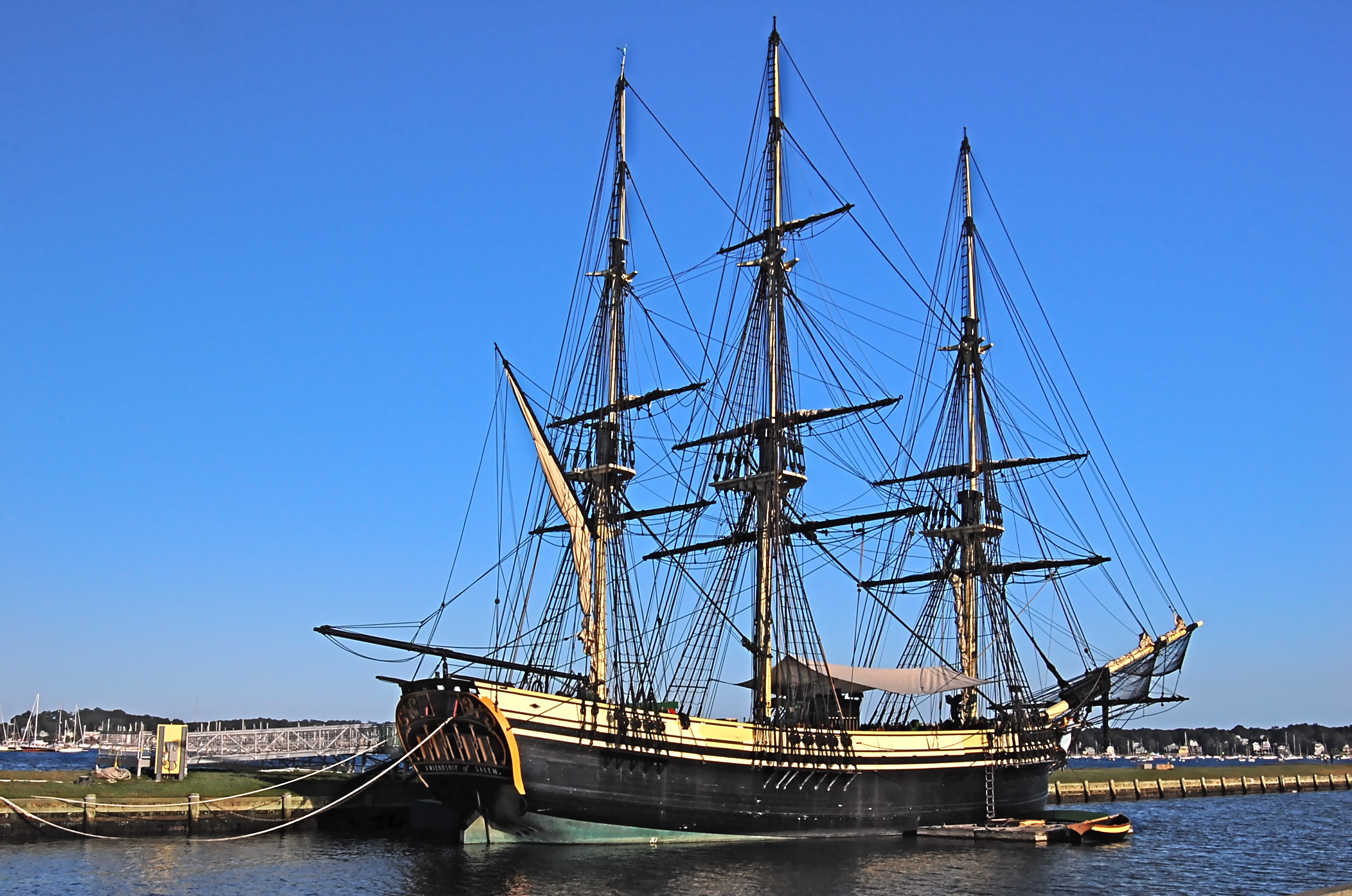
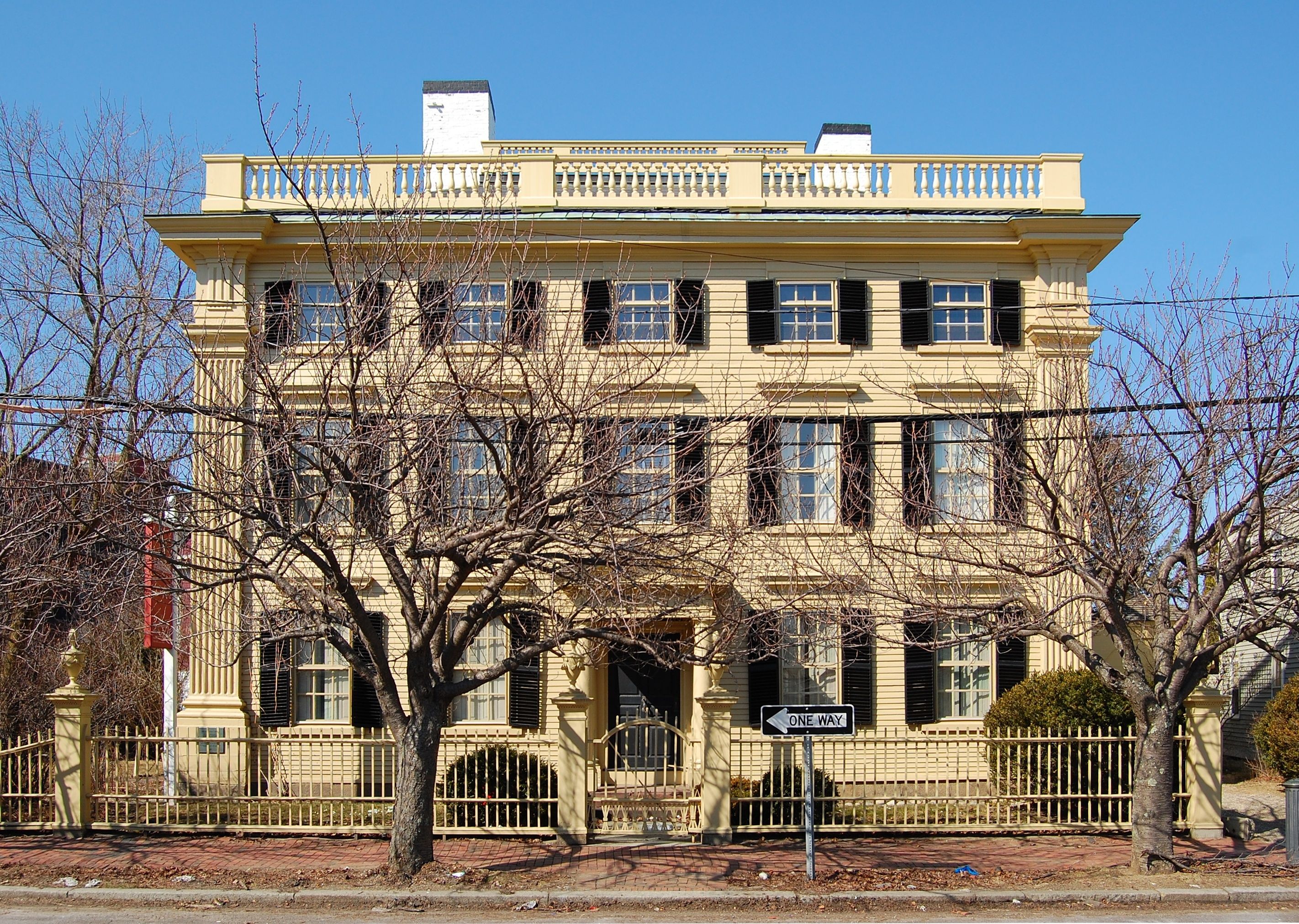
| | | | Salem ships also opened many foreign ports to US trade, such as Calcutta (now Kolkata), Kronstadt (at St Petersburg), Sumatra, Zanzibar, Bombay (now Mumbai), and many others. They returned with spices, tea, silk, hides, sugar, molasses, cotton, wine, chinaware. By 1790, Salem was the sixth largest city in the country, and a world famous seaport, particularly because of the China trade. | | | | But the decline came relatively soon (at least as compared to the decline of Nantucket). There was a presidential embargo declared in 1807 (that was connected with the later War of 1812), and Salem ships sat idle for eleven months, after which the commerce never really fully revived. The high point had lasted just over three decades. Also, newer and larger ships required deeper ports than Salem, and Salem shipping became merely coastal. The last major Salem ship returned in 1893, and the harbor is used today mainly by pleasure boats. Still, Salem never declined like Nantucket, since other industries, such as textile mills, took over to provide jobs. | | | | Salem Maritime National Historic Site Once getting reoriented with the film at the visitor’s center, I visited the wharves and buildings of the Salem Maritime NHS, the oldest NHS in the US (1938). Let’s get reoriented with the aerial view of Salem again. Note again the hotel, and move down to Derby Street in the foreground. Three wharves in the foreground (the middle one just a stub) are within the NHS. Behind the right-hand one, across Derby Street, the building with the white tower is the Custom House, with the historic compound behind it and to its right, including the two adjacent houses. This NPS map makes it much clearer. At one time there were over 40 wharves along this stretch, but most are gone and others reused. The NPS has restored and maintained as typical Central Wharf (1791) on the left, the stub of Hatch’s Wharf (1819) in the middle, and the spectacular Derby Wharf (1762). You can see where Derby had been the same length as Central, but Derby was then extended to its present length in 1806. You can see why Elias Derby was the prominent entrepreneur. The wharves are now mostly lawns, with a small warehouse on Derby, but originally, they were covered with dozens of warehouses--14 on Derby Wharf alone. Picture them with ships, cargo and activity. This is one example where historic imagination is necessary to supplement what is actually visible today. Despite the hot sun, I walked the full 640 m (2100 ft) of Derby Wharf and back, which has exhibits all along it. Picture Elias Derby dispatching some 170 ships from here to China, the East Indies, India, the Baltic . . . | | | | The ship you see pictured at Derby Wharf really is there. The original Friendship of Salem (1797) was an “East Indiaman”, the type of merchant ship that made Salem a leader in the China trade. It made 15 voyages around the world to places like Canton, Java, London, Hamburg, St Petersburg. The full-sized replica (Photo by Fletcher6) (click to enlarge) now replacing it was built from 1996-8. Nearby is the Custom House of 1819 (Photo by Kenneth C. Zirkel), where Hawthorne worked. Note the wide part at its back. It’s a totally separate--but attached, back-to-back--bonded warehouse. As a very clever and informative move, the bonded warehouse, which is open, had replicas of “cargo” in it that is waiting, “untaxed”, for transshipment. I saw tea, barrels of molasses and wine, cloves, silk, sponges, umbrellas, looking glasses, blinds, India textiles. In the early 1800’s import duties owed on a valuable cargo that were not in bonded storage would be between $25K and $90K, formidable sums. The small brick building behind holds the customs scales, which would have been ready to be rolled out onto a wharf. Nearby is the Hawkes House (Photo by Daderot), originally built as a warehouse and later remodeled into a home by none other than Samuel McIntire (1780, 1810), as most houses built by McIntire, in the symmetrical Federal Style. An adjacent brick house is the iconic Derby House (Photo by Daderot) whose interior had so impressed me years ago, belonging to Elias Derby, Salem’s wealthiest merchant and thought to be the first millionaire in the US. It was built earlier, in 1762, in the Georgian style. This entire enclave, after Salem’s maritime period, became filled with working-class tenements, populated during the 1800’s by Irish, but by 1910 was almost exclusively Polish, with some Russians, who worked in factories and mills. Finally, in the 1930’s, the tenements were cleared in order to restore the historic buildings.
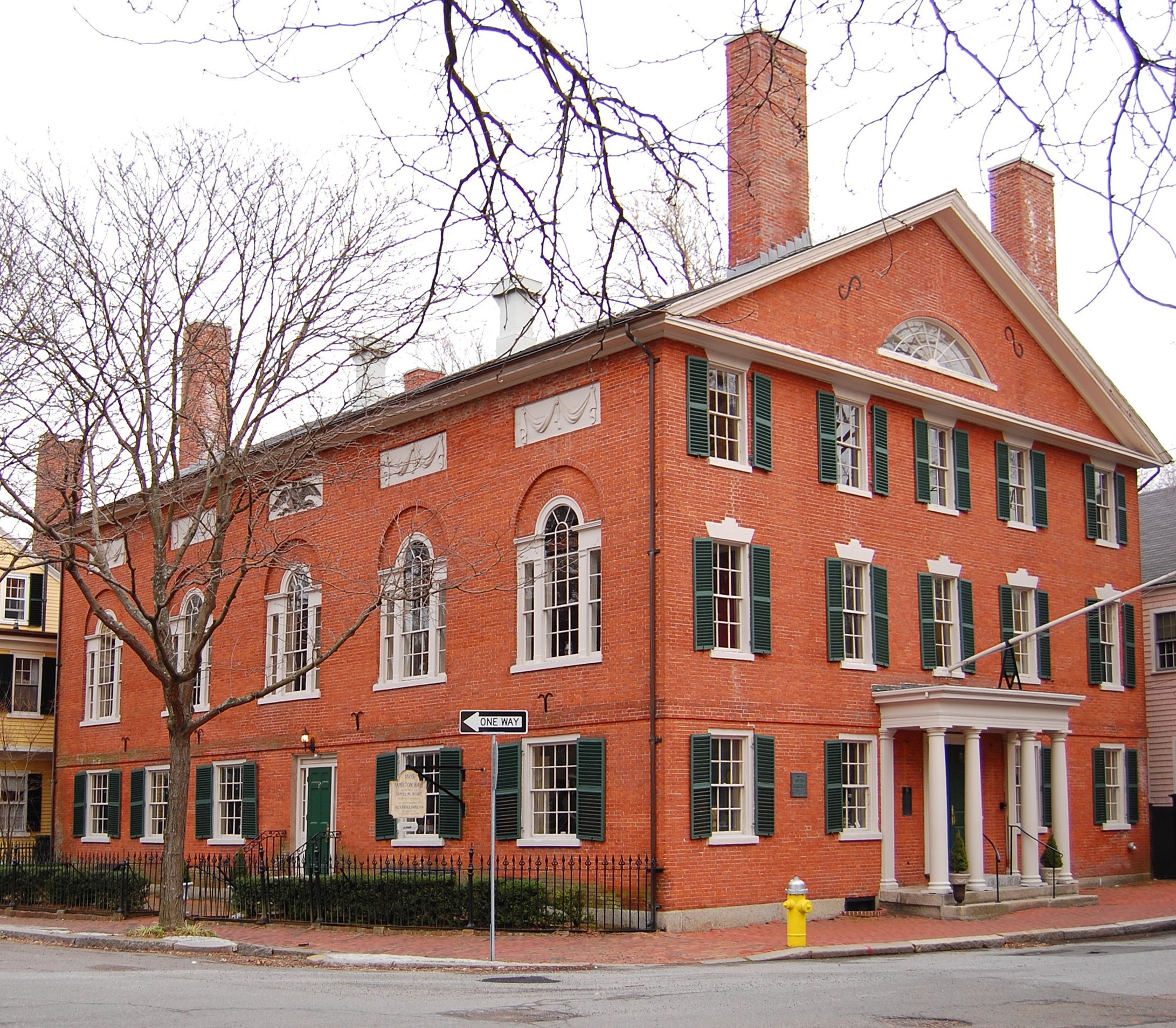
| | | | Samuel McIntire was a Salem woodcarver, artisan, and craftsman, who became an architect, one of the earliest ones in the US. In 2011, a single mahogany side chair with carving done by McIntire sold at auction for $662,500, which was a world record for Federal furniture. Elias Derby had purchased the chair in a set of eight hand-made and hand-carved ones in the late 18th century. McIntire’s architectural services became especially needed when the wealthy merchants and ship owners living in the port area decided after the Revolutionary War that they wanted to escape the waterfront and move to the other side of town, beyond the central business district, frequently choosing McIntire as their architect for the Federal-style mansions that were coming into vogue. (Federal Style is a US outgrowth of the Georgian Style.) In 1981, Salem created the McIntire Historic District, with 407 buildings. It’s Salem’s largest, and contains the largest collection of pre-1900 domestic structures in the US, with a concentration of Federal-Era townhouses on Chestnut Street. | | | | McIntire’s first major commission was the 1782 Peirce-Nichols House. Notice the symmetry and ordered style of the Federal Era. Two of his later works are both on Chestnut Street, Hamilton Hall (1805) and the Philips House (1800).
| | | | From Salem to Concord Once I’d visited nearby Saugus the following day for another dip into the 17C, I’d be on my way to Concord to celebrate 1775. For that reason, I was pleased to read a large historic sign right off the Essex Street Mall in Salem. Since the sign referred to the unit of measurement called the rod, common in this era, let’s have a short aside about the rod.
| | | | [The rod (or perch) was a unit of length equal to 5.5 yards (16.5 ft) or 5.0292 meters. The French name is perche, which shows the derivation of the English variant. English being a Germanic language, its principal name resembles that in the other Germanic languages: in Dutch (as per Dutch Wikipedia) it was a roede (RU.duh), and varied widely in length from city to city, so a sample bar was posted in an official place in each locality. It’s shown here horizontally on the side of the City Hall in Aalst, today partially hidden by flowers. In 1820 it was regularized at 10 meters, and abolished completely in 1937. In German it’s a Rute (old spelling Ruthe) (RU.tuh), and also varied widely in length. This picture on the side of the Historic City Hall in Münster shows a Preussische Halbe Ruthe / Prussian Half Rod. The Rod was still in common use--obviously--at the time the below sign was put up, and remained so well into the 19C, when Thoreau used it frequently when describing distances in Walden.] | | | | The historic sign in Salem read: | | | | | | Three rods west of this spot stood, from 1718 to 1765, the Town House . . .
A town meeting held here in 1765 protested against the Stamp Act and another in 1769 denounced the tax on tea.
Here met, in 1774, the last General Assembly of the Province of Massachusetts Bay, which [on] June 17, in defiance of Governor Gage, chose delegates to the First Continental Congress.
The House of Assembly was thereupon dissolved, and the election of a new house, to meet at Salem, was ordered by the governor, but this, by later proclamation, he refused to recognize [anyway].
In contempt of his authority, the members met in this Town House October 5, and after organizing, resolved themselves into a Provincial Congress, and adjourned to Concord, there to act with other delegates as The First Provincial Congress of Massachusetts.
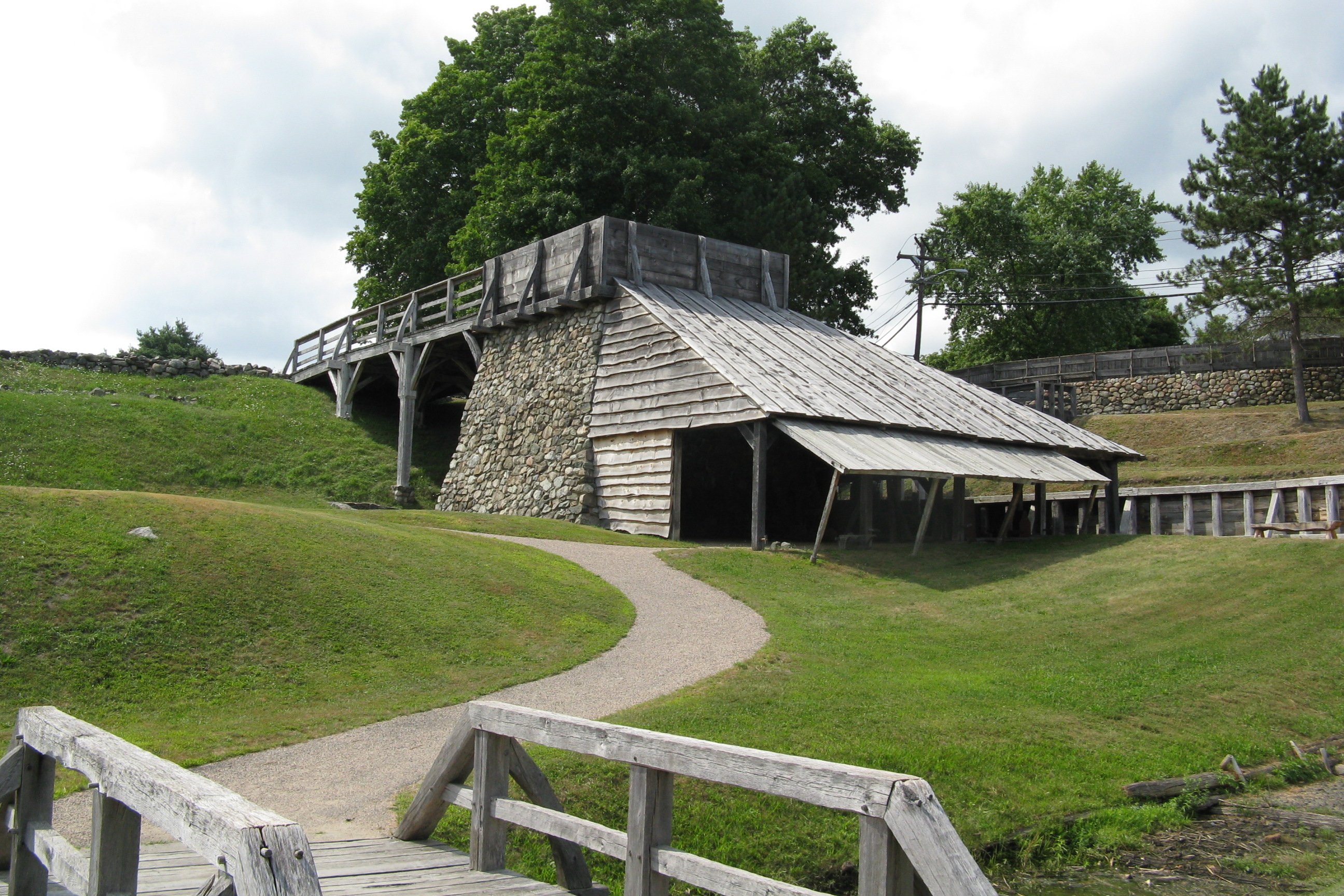
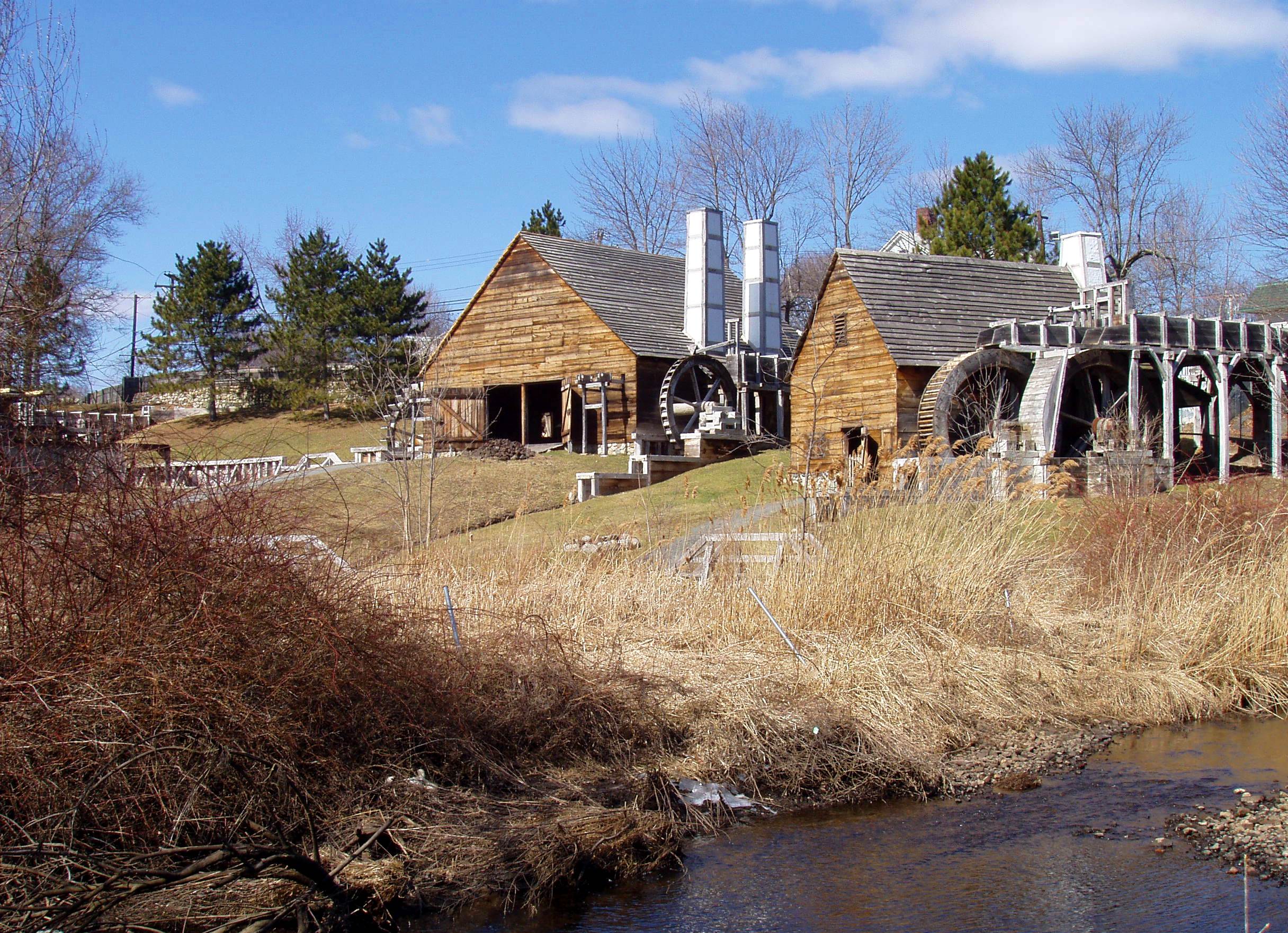
|
| | | | It was a summary of events up to late 1774 that led Salem revolutionaries and others to abandon the royal government, to form a Provincial Congress, and to repair to Concord to start governing Massachusetts with a shadow parliament. The eventful 19th of April, 1775, was just six months in the future. Whither they went, so would I--right after Saugus. | | | | Saugus The stop in Saugus was the highlight of the 17C visits this trip, since it seemed so real. That might seem odd when I say the visit was to the Saugus Iron Works NHS, which at first thought might seem less than appealing. Beverly and I had visited Saugus in 1979, a decade after having visited Salem, and Saugus was a place I wanted to see again to see what further restorations had been done since. | | | | After the full day in Salem, nearby Saugus was to be a partial day, but then I got to thinking about having unwanted down time, so, with advanced planning of transportation, I ended up adding to that day several quick stops in Boston, some offbeat, before heading back to Salem for my last night there before Concord. The Boston stops will be described along with Concord in the next posting. | | | | Saugus, like Salem, lies on the North Shore, northeast of Boston, but Saugus is a bit inland up the Saugus River. Bus connections right from Salem were impractical, so I decided to take an early train back to North Station in Boston, take the Orange Line north to Malden Center, and catch the Malden-Saugus bus, which left right from the combined commuter rail and T station. While most buses elsewhere in the area left frequently, this connection was hourly, and the timing, planned long in advance from information on the MBTA website, worked perfectly. I found Boston buses highly modern. They of course used the Charlie Card, but also had an illuminated readout inside of all bus stops as one approached them, as well as a recorded voice announcing stops. I was in Saugus in about 25 minutes. | | | | The bus stopped in a very leafy residential neighborhood north of the town center directly at the site, which looked much more park-like than I’d anticipated. It had a rail fence surrounded by lawns, and immediately upon entering the gate one saw the only original structure on the site, the magnificent Iron Works House, where the company agent might possibly have lived when the works were in operation. It’s construction date is unknown, but it’s believed to date from the 1680’s, making it the sixth 17C house I’d seen in two days (later that day, I’d visit--and tour--the seventh, the Paul Revere House, c 1680, the only remaining 17C house in Boston). We can already recognize the features of the Iron Works House--and its similarity to the Corwin House--by the steep gables, with the center one protruding (that similar building in the back is the visitors center), the overhang, with a hint of a second one up higher, the central chimney, the casement windows, the corner pendants, the dark, wintery color, all again emphasizing the Medieval character of this style. While this is a winter picture, even in the heat of summer surrounded by a period herb garden it maintained its wintery, brooding aspect. The house had been severely altered by the 19C and by then housed mill workers. A preservationist bought the house in 1915 and restored it, and it eventually went to the National Park Service. It was this house restoration that inspired, three decades later, in the 1940’s, the reconstruction on original foundations of the iron works buildings behind it and down the bluff, next to the Saugus River (actually, a large creek). The archeology team unearthed, in addition to the original foundations, many artifacts, including major ones, such as the remains of the blast furnace, a large section of water wheel, and the 500-pound (227-kg) hammer head. In 1968 the NPS took over the site. | | | | The museum, with artifacts that were found at the site, showed a film about the history of the site. In 1646 the first iron works in America were established here on the Saugus River, and was originally given the very appropriate name of Hammersmith, although it was really named after a small town near London. The site was chosen for its woodlands, raw materials, water power to run the machinery, and water transport to deliver its product, iron, to Massachusetts and even to England. The immediate need for iron materials in the colony, such as an iron blade to be attached to a wooden handle to make a shovel, an iron head to be attached to a wooden handle to make a hammer, iron rims to encircle wooden wagon wheels. Surprising as it may be to consider the Massachusetts settlers arriving in Cape Cod in 1620 setting out to build houses (picture yourself getting off a boat in a wilderness and starting to chop down trees), it is even more amazing that, two and a half decades after that, they built an impressive, world-class manufacturing complex. At the time there were only a dozen such high-tech plants in Europe. | | | | Still, with all their advanced techniques and the skilled ironworkers they imported, the operation was a financial failure, and survived only a couple of decades, with the last recorded blast in the furnace being in 1668. But it served as an impetus for the development of the iron industry in America, since the trained workers spread out elsewhere in the colonies and established other facilities. By the time of the Revolutionary War, the Thirteen Colonies were producing 1/7 of the world’s iron. If it strikes you odd to build an ironworks out in the woods, consider a famous one whose name you already know--although I have no idea if it was a descendent of Saugus. In Pennsylvania, a forge was built in the woods on a certain Valley Creek, so it was known as Valley Forge, which later became the site of Washington’s famous Revolutionary War encampment. | | | | Reconstructed in 1954, the Saugus Iron Works site (click to enlarge), which is a National Historical Mechanical Engineering Landmark, includes three structures of particular interest, the blast furnace, the forge, and the rolling mill. Also included is a functioning reproduction of that quarter-ton drop hammer. It’s odd to see a facility that is essentially a factory with wooden machinery, not metal machinery. The complex is powered by six large wooden water wheels, with some of them driving wooden shafts connecting huge wooden gears and cams. There is also a wharf to load the iron on ocean-going vessels. The facility is surprisingly sophisticated, not only in its iron-making technology and operations, but, more interesting to me, in its 17C engineering and design. | | | | I enjoyed the visit, but there are two ways to look at it. As it turns out, I arrived right after the 9 AM opening on a weekday, spent an hour and a half showing myself around, and was the only visitor the entire time on a very hot morning (there were rangers posted at the visitor’s center). I really enjoyed this, since it was like time travel--just me, all by myself, lost in the 17C, which was a wonderful experience, especially contrasting it with the tourist mill that was 7 Gables. On the other hand, I found out only afterwards that, during the seven months in season the facility is open, there are normally two daily tours of the Iron Works House and two daily tours of the industrial site, where there are apparently workers operating the machinery, although perhaps only weekends. While surprised to find that out--maybe it was because of the heat that tours weren’t running--I’d say I didn’t miss touring the house, since I’ve seen others, and did enjoy figuring out what all the machinery was using the two excellent brochures with maps that were provided. And to top that, I’ve found some great YouTube videos anyway that demonstrate the most interesting aspects of the operation. | | | | Approaching the river bluff behind the Iron Works House (see above map), the three facilities are below at river level. River water upstream had been diverted to a mill pond on the bluffs, and four wooden troughs called races (or flumes) brought the water to the water wheels from above. Three of the races each powered a pair of water wheels, and one race powered a single wheel for the blast furnace. Drop gates at the end of each race regulated--or stopped--water flow. | | | | In considering that, until the steam engine was invented in the late 18C, industry was powered by human muscle, animal muscle, wind power, or water power, and since water wheels are essential to the Saugus operation, and also since I also visited a water-powered grist mill later in the week in Sudbury, let’s distinguish between the kinds of water wheels. Which one is built depends on the features and limitations of the site. The overshot water wheel is the most efficient, since it benefits from energy from the water flow and also the full benefit of gravity. A variation of the overshot is the backshot or pitchback water wheel, which follows the same principles, but is set up to run in the opposite direction. The undershot water wheel is the most environmentally friendly, since it needn’t alter the river with the construction of a mill pond higher than the wheel. However, it’s the least efficient, since the energy delivered has to come completely from the flow, and none from gravity. On the average, the undershot wheel uses 22% of the energy in the flow of water, while an overshot wheel uses 63% because of the added gravity factor. Finally, we have not top, not bottom, but middle: the breastshot water wheel. This one is traditionally the most common one in the US, and can be said to have powered the US industrial revolution. Not surprisingly, though, it is more efficient than the undershot, less so than the overshot, since it makes only partial use of gravity. | | | | Now to the structures. One first comes to the blast furnace, seen here from below, so you can judge the height of the river bluff. Ore and other materials are fed from above from off the bluff, and a huge bellows inside is operated by a single water wheel and the end of its own race. To its right are the forge and mill (click to enlarge; the furnace is barely visible on the left). The mill is here closer to the Saugus River, and on its near side can easily be seen its two wheels and race supplying water. The forge is beyond, and it, too, has two wheels (one race) on the near side, but also two more wheels with a race on the far side. | | | | In the forge, cast-iron bars are converted to more durable wrought iron. The four water wheels power three pairs of bellows (click to enlarge to inspect the wooden shaft coming from the water wheel), one for each work station, and one huge power drop hammer. In the rolling-and-slitting-mill, metal is rolled thin, then a strip is put through what looks like a dough-blender slicing each sheet into about a half-dozen rods. These rods are then later cut into nails. | | | | We’ve now seen the site as I saw it, deserted of other visitors, and in one’s own 17C world, helped along with the two explanatory brochures with maps. Now let’s all together see some action via YouTube. | | | | | | Watch the startup of this overshot water wheel. After initial splashing, it settles down. Note all the wood in its construction, including the shaft.
Watch this undershot water wheel on the left side of the forge and follow the wooden shaft until you see it’s running the same pair of bellows we saw in the above photo.
I don’t think it gets better than this. I can’t stop watching this shaft and cam, right off the water wheel at the forge, running this power drop hammer. If you have any doubts as to what water power can do, in the 17C or now, or about “ancient” 17C engineering methods, just remember this hammer in operation and that that hammer head weighs a quarter ton.
Finally, watch this craftsman in the rolling-and-slitting mill making nails, one at a time, from the end of a rod that’s been rolled and slit. And that’s one . . . nail . . . at . . . a . . . time. Watch the effect of the bellows.
|
| | | | Leaving the 17C, I caught my 21C bus back to the Malden station and the Orange Line to see selected sites in Boston, which will appear on the next posting with Concord. | | | | New York Earthquake As I was completing this posting here in Manhattan yesterday, 23 August 2011, I experienced the east coast earthquake that’s been reported on the news. I also remember the morning in our Purchase house up in Westchester County some years ago when the bed shook and woke us up, but we were still foggy as to what had happened. Today’s was a more “complete” experience that I was fully aware of. I was reading the Times at 1:51 PM with a cup of coffee, and all of a sudden it was quite obvious that the table and everything else was moving slightly between me and the window, that is, in an east-west direction. If I’d thought I was dreaming, I can clearly say that the coffee in my glass-bottomed coffeepot on the table was also sloshing back and forth. It lasted maybe 20-30 seconds. I checked online and the 5.8 quake was centered in Virginia, and felt all along the coast. Reports were coming in most notably from Washington and New York. Some buildings in New York, including City Hall, were evacuated, as was the District Attorney’s press conference about Dominique Strauss-Kahn. I, on the other hand, proceeded to calmly finish both my coffee and the Times. | | | |
| |
|
|
|

