|
Reflections 2012
Series 11
July 20
Continental Interlude: Hamburg - Travemünde
| | Scheduling fate had put together two different, yet similar, halves to this trip, each about three weeks long. I had just completed the first half, involving Atlantic islands associated with Mediterranean culture and with the transatlantic expansion of that culture, and was about to visit Atlantic islands associated with Nordic culture and with the transatlantic expansion of that culture. | | | | [It also strikes me that it was countries literally on Europe’s west coast that did the major expanding: first the Norse across the northern route as far as Newfoundland, then Portugal and Spain across the southern route into the Caribbean and beyond, then Britain and France across the middle route to the bulk of North America. It’s odd that the pattern is so symmetrical.] | | | | An interisland flight from Tenerife back to Gran Canaria allowed me to make my connection to Hamburg, from which I could easily get to Travemünde, from which the MS Deutschland sailed to the northern islands. My time in Hamburg and Travemünde would be my “continental interlude” between islands. (Actually, the first stop the ship would make, in Stavanger, Norway, would be just as “continental”, but I’ll consider that stop among the islands, since Stavanger is essential to the Nordic expansion theme.) | | | | Air Berlin For the connection, I’d chosen Air Berlin. In spite of all the trips I’ve taken ending up in Germany, either by ship or by a flight arriving elsewhere in Europe, I believe I’ve flown directly to Germany only once, by Lufthansa to Hannover. I was unfamiliar with the current status of airlines, and had heard of Air Berlin only as a charter airline, so far behind the times in regard to airlines was I. I chose it because it had the best connection, but then I researched it, and the history of its founding, and subsequent expansion, made it worth telling the story. It was founded as a US airline (!!!) and is no longer just a charter airline.
| | | | It’s another Cold War story. Access to (West) Berlin across East Germany was allowed only on three specified rail routes, three highway routes, and three air routes (corridors). These corridors were only available to French, British, or American airlines, which had to use their nationals as pilots and crew. It was via these air corridors that planes of the Berlin Airlift / Luftbrücke (“Air Bridge”) had supplied Berlin during the blockade of 1948-1949. | | | | By 1978, Berlin access was still limited, and a former Pan Am pilot formed Air Berlin to access Berlin, so the name Air Berlin, now a historical reference, makes very good sense. It was set up as a non-scheduled (charter) US airline in the state of Oregon, and headquartered in Miami. In time it developed charters from Germany to popular island resorts, such as the Ballearics (Mallorca) and the Canaries (!!!), and in 1985, the Cold War over, it moved its headquarters to Berlin and later became a German airline. It is now Germany’s second largest airline, after Lufthansa, and Europe’s sixth largest airline in terms of passengers. Thus, by chance, I happened to book an airline with an interesting history, plus a long-term server of the Canaries. | | | | The trip to Hamburgo / Hamburg was fine, but I could sense that the plane was filled largely with vacationers returning from the Canaries, especially when, on landing, we were welcomed “home”. The diagonal route crossed Portugal, Spain, France, Belgium, and the Netherlands to Northern Germany, but crossed only one time zone, losing an hour. It’s rare, in my experience, to fly almost five hours and not be involved with jet lag. | | | | S-Bahn Still, as we arrived at Hamburg Airport, it was quite late in the evening. Fortunately, the airport is only 8 km (5 mi) north of town, and even more fortunately, in 2008, the Hamburg S-Bahn (suburban railway) was extended to the airport, with a stop located under each terminal, affording a 25-minute ride to the Hauptbahnhof / Main Station about every 10-15 minutes. | | | | I would leave it at that, except that this train, the S1 in this updated configuration, does something that I find quite unusual for urban rail. It splits and rejoins. I’m familiar with long-distance trains, especially in Europe, which start at A, but at B separate into two sections, one going to C and the other to D. You have to be sure early on you’re in the right part of the train. Returning from C and D, they rejoin at B to go to A. But I’ve never seen this happen in urban rail before. | | | | This is the map of the Hamburg S-Bahn and U-Bahn (subway) systems (click to enlarge). Note in green the S1 from the airport merges with cars coming from Poppenbüttel at Ohlsdorf to continue to the Hauptbahnhof and beyond. The night I arrived, knowing this would happen, all I felt was a slight bump at Ohlsdorf, when we hooked up to the Poppenbüttel cars up front. I remained curious, and the next day, having bought a system day pass anyway, after I finished seeing what I wanted to, I went back to Ohlsdorf and watched one northbound train separate, then a southbound train join. Observing the clever coupling mechanism at close range (an employee is on hand to make sure it works well), I could see how easily this system functions. | | | | [If you’re interested in my later connections and have the above map handy, note these trips departing from the Hauptbahnhof: (1) the dark purple S3 line two stations south to Veddel/BallinStadt, on an island between the two branches of the Elbe; (2) the same dark purple S3 or the above green S1 two stops west to Landungsbrücken / Landing Bridges, on the north bank of the Elbe; these are the two destinations I had the next day on my day pass, and (3) the gray Regionalbahn / Regional Rail line leading to the upper right of the map at Bad Oldesloe, and then off the map to the right on to Travemünde, which I did the day after that.] | | | | Hamburg I’ve been in, or traveled through, Hamburg many times. This is the second time I’ve enjoyed staying on Kirchenallee on the east side of the Hauptbahnhof, given the wonderful convenience to transportation. My most recent full visit to Hamburg is described in 2006/9, when, after visiting Scandinavia, I took that wonderful two-night Finnlines voyage from Helsinki to Travemünde-Skandinavienkai, then on to Hamburg. My most recent stop was just a pass-through on 8 July 2008 (2008/16), coming up from Africa and Switzerland to get on the Queen Mary 2 in Hamburg, where I first met friends Paul and Marya while boarding the ship. | | | | I always enjoy the Hamburg Hauptbahnhof because it’s so open and airy. It’s a true station and not a terminal (thank goodness), so it’s particularly convenient--the above map shows how trains come and go both ways. As a matter of fact, when it opened in 1906, its purpose was to replace four terminal stations that were very close to each other, with duplication of effort and inconvenience in changing trains. The oldest station it replaced dated from 1842; two others were the 1846 Berliner Bahnhof and the 1865 Lübecker Bahnhof. | | | | It was originally designed in Jugendstil / Art Nouveau style, which Kaiser Wilhelm II declared to be “simply horrible”. He personally changed various style elements into the Neo-Renaissance style, giving the station a fortification-like character. During WWII, the station was hit seriously by Allied bombing on 9 November 1941, and several areas needed to be rebuilt. One of the clock towers was destroyed in 1943.
| | | | It has an average of 450,000 passengers a day, making it the busiest in Germany and the second busiest in Europe after the Gare du Nord in Paris. It being a through station under a huge roof, it has island platforms reachable from two crosswalks via escalator or elevator, this picture being taken from one crosswalk over to the other. | | | | BALLINSTADT Life surprises. Last November I was sitting on a train returning from Churchill and speaking with Georg Witschel, the German Ambassador to Canada (2011/29), when the subject turned to a special project he was working on involving emigration/immigration. He mentioned several museums in Canada and Germany he was studying, including BallinStadt (BallinCity) in Hamburg, a 2007 reconstruction of the Auswandererhallen / Emigration Halls built by Albert Ballin (ba.LEEN) in 1901 on Veddel (FED.el), a large island in the Elbe, to accommodate the large numbers of emigrants from all over Europe about to cross the Atlantic. I suspected my maternal grandfather from Minsk might have possibly been housed there when he emigrated in 1905 (2011/5), and possibly also, several years later, my grandmother and eldest aunt, then four years old. Ballin was the distinguished director of the Hamburg-America Line (HAPAG), a major transporter of emigrants, who wanted better facilities for them. As I explained in the earlier writeup: | | | | | | There were about 30 separate buildings, including sleeping and living pavilions, dining halls, baths, a music pavilion, church, synagog, and medical facilities, as well as a rail connection. This mass accommodation was to provide a secure location for the thousands of emigrants arriving weekly from all over Europe and who were waiting for passage. The stay, including room and board, were all included in the price of the ship ticket. It was Ballin who sent out recruiters to East and Southeast Europe to bring in potential emigrants, which led Hamburg to surpass Bremen in 1891 as the leading port of emigration. The medical facilities “pre-quarantined” emigrants for 14 days to lessen the possibility of their being sent back at the expense of the shipping company. |
| | | | I had told Georg I’d have to put BallinStadt on my itinerary some day, and, as I said, life surprises. Seven months and a week after we had that conversation, I was in Hamburg, having allowed enough time to spend a day there, and on my way to BallinStadt. I bought my S-Bahn/U-Bahn day pass and took the S-Bahn from the Hauptbahnhof two stops to the Veddel/BallinStadt station in the middle of the Elbe. The following are my notes based on what I found in the museum that interested me. | | | | Of the thirty-odd original U- and H-shaped dormitories, three have been reconstructed as the museum, in some cases with a glass pavilion in the center of the U to extend the exhibition space. New arrivals were handed tickets they had purchased and passports (???). They had to pay their own room and board at BallinStadt in the dormitories. For those who could afford it, there were two hotels, each room with four beds. All arrivals were disinfected and the sick were set apart, to be taken care of separately. There were three meals a day in huge dining halls. There were separate kitchens, since one was kosher. | | | | I had heard from ship expert Bill Miller about the emigration agents that solicited for the shipping companies, and that I suspected might have possibly influenced my grandfather to emigrate. Looking at a map, I realized that at the turn of the 20C, the Russian empire bordered the German empire, with no Poland in between, so I could understand even better how agents could just cross the border into the next country to search for emigrants. I then read at the museum that such agents, shall we say, had to present themselves as mere ticket sellers and couldn’t actively solicit people to leave, since the Tsar wanted to maintain a labor force and a source of soldiers. (Anyway, my grandfather had already served in the Russo-Japanese War.) Therefore, these agents became shady characters using deceptive practices, such as presenting fake letters of supposedly successful emigrants. Now my grandfather couldn’t read or write, so if any fake letters were presented to him, they’d have to be read to him, but who knows? Of course, any emigrant who signed up had to use the company the agent represented. | | | | The museum showed a selection of posters, one in Russian for HAPAG, the Hamburg-America Line. Some of the writing on this poster was in German, but it also said Германская Параходная Компания (Germanskaya Parakhodnaya Kompaniya, or German Steamship Company), followed by ГАМБУРГ-АМЕРИКА ЛИНИЯ (GAMBURG-AMERIKA LINIYA). If my grandfather had seen this poster, he couldn’t have read it, but the picture of the steamship was impressive. | | | | [Bothered by something above? Is it Hamburg or Gamburg? I will remind of something we talked about in the past. H in the Latin/Roman alphabet is, for some odd reason, usually transliterated into the Cyrillic alphabet as a G. Of course, I could have re-transliterated it back to an H, but it’s more fun to see Hamburg start and end with the same letter. So are references to Shakespeare’s Gamlet to Amsterdam in Gollanda.] | | | | There was an interesting table showing overland travel options over the years. Saint Petersburg to Hamburg is 1,918 km (1,192 mi). It said that walking (???) would take 48 days; riding in a carriage in 1850, 19 days; taking a train in 1880, 3 days; driving a car in 1920, 6 days; taking a plane today, 3 hours. | | | | Ballin improved living conditions for steerage passengers, who crews had treated as freight. A display showed what life in steerage in 1876 would have looked like. Everything was made of wood, like a mountain cabin, with two-level bunk beds to accommodate hundreds of people. There were pails, clotheslines, kerosene lamps, and washboards all about. Steerage passengers were allowed up on deck for one hour a day, but only in good weather. There they could see how the passengers in 1st and 2nd class lived. Emigrants with more money lived in a cabin shown in another display. It was a simple cabin, but it did have its own sink, and was comfortable. A final indignity took place on arrival in New York, where 1st and 2nd class passengers were examined on board, and then dropped off in Manhattan. Steerage passengers stayed on board to be dropped off later on Ellis Island for examination. All the museum displays were very revealing of the emigrant experience. | | | | ALTER ELBTUNNEL From Veddel I made my way by S-Bahn via the Hauptbahnhof to the Landungsbrücken / Landing Bridges, early 20C structures on the north bank of the Elbe used for docking and as a public esplanade. It was my intention to walk to the south side of the Elbe and back. For this I’d use the Alter Elbtunnel / Old Elbe Tunnel. | | | | I’d done many things in Hamburg, but found out about this online only when planning online earlier how to finish my day. As the name implies, a Neuer Elbtunnel / New Elbe Tunnel was built in 1975 to modern highway standards, and, along with various bridges, it takes the brunt of the cross-river traffic, but the old tunnel is still in use, not only for pedestrians, but also for cars. It originally also accommodated carriages.
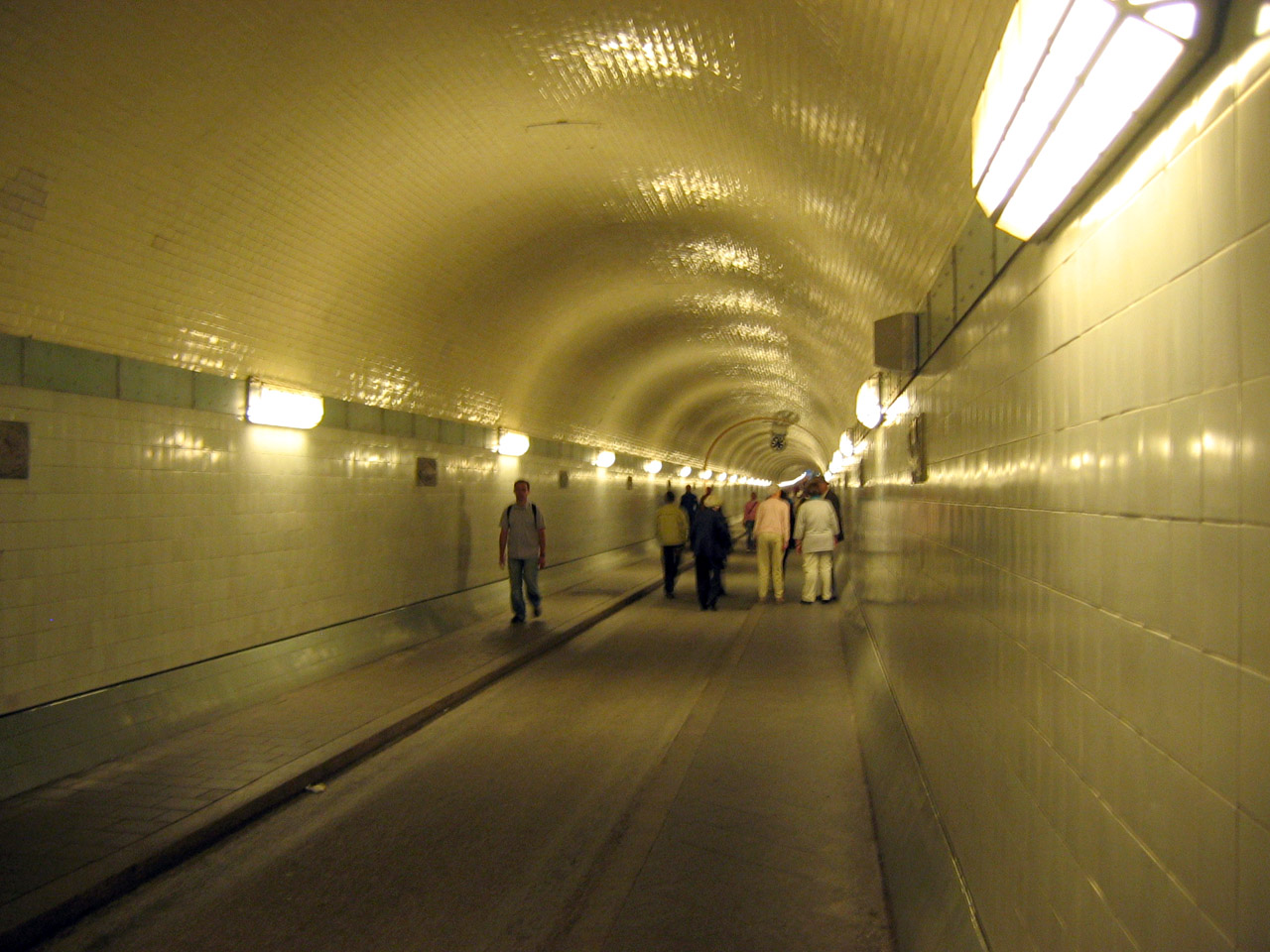
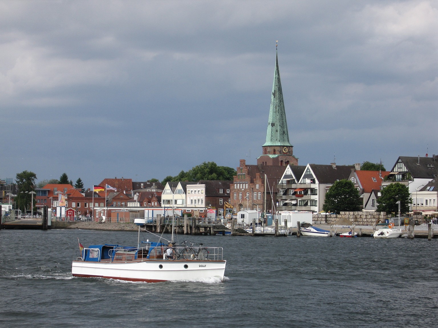
| | | | The tunnel connects the entertainment district of Sankt Pauli (the official name is the Sankt Pauli Elbtunnel) on the north bank with Steinwerder, which is on one of the long, narrow islands in the center of the river (such as Veddel, but further downstream). The tunnel was planned as of 1901, and built from 1907 to 1911, which means it celebrated its centennial last year. It was a technical sensation in its day, but today seems so petite and nostalgically quaint. Still, it was the first river tunnel on the continent, and was sorely needed at the time, due to increasing traffic. The model used was the Clyde Tunnel in Glasgow, after all other river-crossing possibilities were rejected. | | | | The tunnel is open 24 hours a day, free, for pedestrians and bicycles, and limited hours for vehicles, for a €2 charge one way. In 2008, about 700,000 pedestrians, 300,000 cars, and 63,000 bicycles used the tunnel. | | | | Other than the fact that it’s small and quaint, there doesn’t seem to be anything unusual about the tunnel, but that’s because I left out an important point. There are absolutely NO approach roads, just city streets, for vehicles to either end of the tunnel. So how do people and bicycles--and especially cars (and once carriages)--get down to the tunnel and up again? What’s your guess? | | | | Since 1911, this has been accomplished by elevators at either end! This is a principal uniqueness that makes the tunnel so endearing. Let’s first take a look at a diagram of the Alter Elbtunnel. This is a north-south cross-section (Querschnitt), the Sankt Pauli entrance (Eingang) is north; the inset is a cross-section of the one-way tubes, which are shown at the bottom, as seen from above. There was construction going on while I was there on the elevators, and I only saw one tube, so I suppose the other was under repair. People and bikes went both ways in the one tunnel, but the cars had been set up to south-to-north, presumably periodically reversed. | | | | You can see that the height of the elevator shafts is 23.5 m (77.1 ft), and that the length of the tunnel(s) without the shafts is 426.5 m (1,399.3 ft). The tubes have a diameter of 6 m (19.7 ft) and the two together are 14 m (45.9 ft) wide. You can tell in the cross-section that there’s just one car lane in the center, and a sidewalk on either side. Since we were only using one tunnel, the sidewalks were each one way, which made sense, but is somewhat unusual. The height of the Elbe above the tunnels is 12 m (39.4 ft). Each shaft has car elevators in the center plus a passenger/bike elevator to either side of the car elevators. | | | | This is the view of the north entrance in Sankt Pauli, the green domed building on the left. All the other buildings to the right up to the tower are the Landungsbrücken. The high church tower is the Michaeliskirche, St Michael’s Church, a symbol of Hamburg, affectionately known as Langer Michel / Tall Mikey, because of its height. This view is looking up at that dome through the elevator shaft on the north end. Either one or two cars fit onto each elevator; sometimes bikes sneak in with them. | | | | But the fun is walking through the narrow tunnel. You see the two sidewalks; perhaps no cars were running when this picture was taken, but when I was there, they came periodically, based on the elevator service. I timed it, and it took only six minutes to walk the length of the tunnel. The middle was marked “Tunnelmitte”. The walls were decorated with majolica tiles of flounder and other fish, lobster, eels (the plaques are barely visible in the walking picture). At Steinwerder, before returning, one has a nice terrace view over the river, and north bank, including Langer Michel. | | | | Travemünde The next day it was off to Travemünde by rail, via Lübeck. Since 1802, Travemünde has traditionally been the seaside resort for both cities, and on summer weekends, there are through trains from Hamburg, but otherwise, it’s a change in Lübeck, which gives us a chance to talk about that connection. Hamburg and Lübeck were first connected by rail in 1865, and a decade later, the route was double-tracked, indicating its importance. You may remember that one of the four terminal stations the Hamburg Hauptbahnhof replaced was the 1865 Lübecker Bahnhof, which was the original end of this line, so the Hamburg-Lübeck route has a long history. Note how the S-Bahn to Poppenbüttel (with branch to the airport, not shown) is connected to this line, and recall how Bad Oldesloe was even close enough so that it showed up on the S-Bahn map. My train was express to Bad Oldesloe (ol.des.LOH), and stopped only in Reinfeld before Lübeck Hauptbahnhof. | | | | I’ve always liked the rail stretch from Lübeck to Travemünde. It’s out-of-the-way, quiet, rural, and one-tracked. You can tell why, since it dead-ends at the Ostsee (“East Sea”) / Baltic Sea beaches, and primarily serves them plus the Baltic ferry traffic (also freight). It was built as far as the original stop, L-T-Hafen, in 1882 and electrified only in 2008. After the line was built, the railroad introduced the slogan “Hamburg, Lübeck, Travemünde--Aus dem Häusermeer an die See (From the sea of houses to the sea)”, setting up a curious contrast between the two German words for sea, “Meer” and “See”. In any case, the theme was “beachy” from the start. | | | | Let’s first clarify the apparent doubling of names. When smaller cities and towns become part of a larger city in Germany, both names are used, big city first. For instance, when Beverly and I lived in Gonsenheim, part of Mainz, the address read Mainz-Gonsenheim. You can see on the map that Lübeck has assimilated a number of municipalities, and can also see which ones are still independent. The surprise might be that Lübeck has long taken over its port of Travemünde, which is now a neighborhood of Lübeck, so the complete name is properly Lübeck-Travemünde (which I will continue to shorten). | | | | This second train stopped only once before the three Travemünde stops, so the distances aren’t so far. Even these stations are only two minutes apart from each other. L-T-Skandinavienkai (Scandinavia Quay) is the most recent station, added specifically to service the ferries serving Sweden and Finland, which come a bit further upriver here. It’s the station I used when I came in on that wonderful Finnlines ferry in 2006, the Finnhansa. The station was added when it was realized that the middle station, the original one, L-T-Hafen (Harbor) wasn’t close enough. L-T-Hafen was the last stop from 1882 until 1898, when the line was logically extended to L-T-Strand (Beach), a couple of blocks from the seaside. L-T-Strand originally had a simple wooden station, but traffic increased so much with a station so close to the sea that in 1911 they built the present station in Jugendstil / Art Nouveau (apparently this time Kaiser Wilhelm wasn’t paying attention). It was recently renovated and is a listed historic site. The station is beautiful, inside and out, and fits its quiet seaside neighborhood perfectly. It’s made of brick, a very common feature all around the Baltic. As you can tell, the oddity of the station has always been its clock tower, where, below the clock, a digital readout gives the time of the next outbound train above the words “Zug nach Lübeck” (train to Lübeck). This charming feature is visible from the beach. I hate to be a spoilsport, but nowadays, the trains leave regularly, every hour, currently at 34 minutes after the hour, so the clock isn’t totally necessary any more. But don’t tell anyone, and join in the fun.) | | | | The Deutschland was to sail from the center of town, where the river esplanade is called the Vorderreihe (“Fore-the-row”, pronounced for.der.RAI.uh, AI as in AIsle), since it’s located in front of the row of building façades, that is, the building line, along the Trave (TRAH.vuh). The river edge of the Vorderreihe is called the Ostpreußenkai (East Prussia Quay), where there is a discrete, modern terminal set in among the café tables. (East Prussia, in the eastern Baltic, is now in Russia and Poland, but the ferries going there used to leave from here, and the name has been retained.) Ostpreußenkai is equally reachable from either L-T-Hafen or L-T-Strand, so I chose to stay at the seaside neighborhood. They’re only a few steps apart, anyway. | | | | Take another look at this same rail map we just saw, since it’s the best local map I have to explain two things. Note the point not far from the last stop where the Trave enters the Baltic. That’s exactly where my hotel was (very well) located, with the Strandpromenade / Beach Promenade to the east and the Travepromenade along the river to the south. It was just a short walk down the Travepromenade to the town that first day and to the ship the next day. | | | | But much more important to contemporary history, we need to talk about when Travemünde was on the “edge of the world”. Note on the left of the map that this whole area is in the state of Schleswig-Holstein. That includes all of Travemünde to the north of the river, the Trave river itself, that large spit of land called the Priwall Peninsula (part of Travemünde), and that bay called Pötenitzer Wiek. The dotted line you see separates Schleswig-Holstein from the next state, Mecklenburg-Vorpommern. During the Cold War, that state line was also the line between West and East Germany, so close was Travemünde (Lübeck, too) to the border, and at one point, the south bank of the Trave itself was part of the border. Actually, where the Priwall Peninsula is connected was the northern terminus of the inner-German border, and I understand a few remnants of the border fortifications have been preserved near the beach. This rather poor picture shows border fortifications on the beach in 1990 at the crossing to Pötenitz on the other side, after which Pötenitzer Wiek is named (Grenze=border). | | | | We still haven’t clarified the name Travemünde, so let’s do it this way. It has traditionally been rather common in England to name a town located at the mouth of a river after the river, but people don’t always realize that’s the case. The names Plymouth, Dartmouth, Exmouth, Weymouth, and many more show this. There really is a Ply River, a Dart River, and so on. This is even less realized when these names are transposed to other English-speaking countries, where the actual rivers are not factors. The only quirk about using -mouth as a suffix in English is that it changes its pronunciation to MITH, as in PLI.mith and DART.mith. | | | | The German word for a person’s mouth is “Mund”, and a river mouth is a “Mündung”, but as a suffix it appears as “-münde”. I don’t see that it’s done as often as in England, but aside from Travemünde, on the Baltic there’s also a Peenemünde and a Swinemünde, each named after the river it’s on.
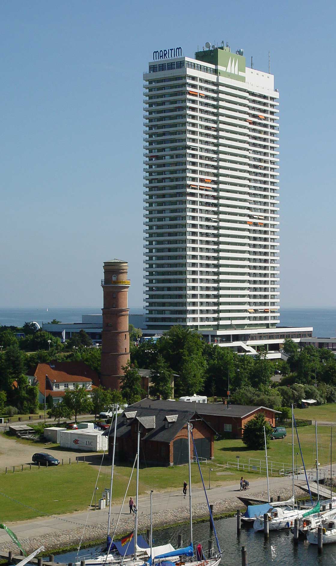
| | | | PASSAT Since Travemünde is a port, one of its museums is a historic ship, the four-masted Passat (pa.SSAHT), which means “Trade Wind”. It sits near the mouth of the river on the Priwall side, to which one would have to take a small ferry to reach. The ship was launched in 1911 and is one of the last surviving windjammers. Surprisingly for me, the Passat is a sister ship to the Peking, located at the South Street Seaport Museum in lower Manhattan, of which I am a member. Beyond the trees in Priwall, which is still in Schleswig-Holstein, in the distance is the state of Mecklenburg-Vorpommern, at one time in East Germany. | | | | ALTER LEUCHTTURM On the north side of the river, across from the ship, is the oldest lighthouse in Germany, dating from 1539 (which in turn had replaced an original one from 1226), Travemünde’s Alter Leuchtturm / Old Lighthouse (literally “light-tower”)--the name is readable on the yellow banner (click to enlarge). It’s a charming little eight-story structure, at 32 m (102 ft) of a proper height to fit into the town’s scale. But in 1972 it was put out of service and became a museum. Why? Its view became blocked. How could that happen in such a small-scale town? For the answer we move from the sublime to the ridiculous.
| | | | MARITIM The blockage was due to the construction of the Maritim Hotel, which was finished in 1974, with 35 floors. To replace the lighthouse light, on its roof was built instead the highest Leuchtfeuer (“light-fire”) / beacon in Europe, at 115 m (377 ft), more than triple the height of the lighthouse’s light. Click to enlarge the picture to see the Trave in the foreground, and the Travepromenade leading into town. Behind the Maritim (ma.ri.TIM, rhymes with “team”) is the Baltic, and the beach, with the Strandpromenade. | | | | The Maritim is the highest building in Schleswig-Holstein, as well as on the entire German Baltic coast. On the top floor is a restaurant, then below it, 22 floors with 350 private apartments, then 10 hotel floors with 240 rooms. The lower level, which has a larger footprint than the tower itself, is devoted to the lobby and reception desk, conference rooms, and more restaurants, plus three underground garage levels. | | | | I had been torn when booking a hotel room online. A building like this should not have been allowed to disturb Travemünde’s skyline. On the other hand, it’s extremely well located at the mouth of the river, walkable from the rail station, closer to town than the other beach hotels behind it, and has perfect views of everything, so I yielded and booked a room at the Maritim for my one night in Travemünde. And I was right about the view. While I was on the fifth floor in the hotel area, and this is from the roof, still there’s a marvelous view of the Trave, Passat (and passenger ferry to it), Priwall Peninsula, and in the distance, Mecklenburg. To the left would be the view out to the Baltic. | | | | A Stroll Through Travemünde When the train got me into the Travemünde-Strand station, I found myself in a peaceful, calm, idyllic world. Around the charming station building were trees, cafés, and a laid-back, casual ambience. Immediately to the left of the station was a beautiful, quiet park, the Godewindpark, inviting the visitor, but first I had to drop off my bag, so I walked a few blocks toward the river to the Maritim, and checked in. It was still late morning and my room wasn’t ready, so I left my bag and backtracked to the station and the Godewindpark. The park was peaceful, and in the middle was a quiet lake with swans, absolutely idyllic, and I sat on a bench and just passed a bit of time with nature. It was a nice, relaxed way to start the visit of Travemünde, and set the tone. | | | | Leaving the park from a side exit, I was in an upscale residential, beach neighborhood, and two blocks from the beach on the Baltic and the wide Strandpromenade. I started walking along the beach on the Promenade southward towards the Maritim. It was a perfect day, but apparently not quite warm enough for beachgoers, since there were few people on the beach, with many more on the Promenade. | | | | STRANDKÖRBE It’s when I mention the beach that those that know Germany will picture one thing, and those that don’t will picture something quite different. Do not picture the few people that were on the beach sitting on blankets, getting sand in their sandwiches, and wondering who’d watch their things if they went into the water. This is Germany. Welcome to the world of the Strandkorb.
| | | | Where to start? Strandkorb is pronounced SHTRANT.korp, which literally means “beach basket”, probably since it’s mostly made of wicker, is better translated as “beach chair”, and even better “wicker beach chair”. They are absolutely typical on all German beaches, both on the Baltic and the North Seas. Other languages use the German name; the only language Wikipedia lists with its own version of the name is Danish (strandkurv). I would assume that, since the Baltic and North Sea beaches continue up the Jutland peninsula to Denmark, they might be known there as well. A Strandkorb is a very civilized way to visit the beach, especially in the north with more winds and cooler weather. It’s a special chair providing comfort and protection from sun, wind, rain, and (blowing) sand. At one time Strandkörbe (the plural) were Einsitzer / one-seaters, but now are almost universally Zweisitzer / two-seaters (note the couple in the Strandkorb in the background). Today’s models have tiltable tops that go down either halfway or fully flat, so that one can lie in the sun. They usually have armrests and footrests, storage space below the seats (especially good when you both want to go into the water), rainproof covers, fold-down tables, and awnings. In the picture, note the handles on the sides, to turn it in any direction you like, and the gates on the chairs in the back, which the concessionaire will remove when you rent the Strandkorb. A Strandkorb is like a (beach) home-away-from-home. | | | | Strandkörbe stand on German beaches in rows and rows, like sentinels. Note next to the concessionaire’s booth on the right #13, whose top is leaned halfway back, and also how the awnings are lowered on these. Beverly and I rented a Strandkorb on the nude beach in Sylt on the North Sea side, and it was very comfortable. | | | | Usually, there are several concessionaires, each with a number of rows of Strandkörbe, often differentiated by colors. I made a note of the fees at this beach. Regular ones were €8, ones that could lay flat were €9; if you arrived after 3 PM the price was only €6. There were also weekly and seasonal rates. And by the way, totally unrelated were the charges for beach use (a euro is worth about a quarter more than a US dollar): €2.60 per person per day, but if you got there after 3 PM it was €1.50. You bought a ticket at a machine, and had to hold onto it in case of spot checks, just like the subways work in most European cities.
| | | | The Strandkorb is so typical that many outdoor restaurants and cafés around town had a couple of them as seats at patio tables. And they’re nothing new--they’ve been around for 130 years. They were invented in 1882 by a Rostock basketmaker (what else?) for a rheumatic woman who wanted an easy way to visit the beach in Warnemünde, and the idea spread like wildfire to all German beaches. Curiously, he did name his invention a Strandstuhl / beach chair, which remains the best way to translate it, but the name quickly changed to Strandkorb / beach basket, perhaps for humorous reasons. | | | | Thomas Mann’s highly successful 1901 first novel, Buddenbrooks, about several generations of a wealthy Lübeck family in the period from 1835 to 1877, makes reference to vacationing at the beach in nearby Travemünde in the 1840’s. In Part Three, Chapter Seven is the following line, with my translation: | | | | | | “Die Reihe der hölzernen Strandpavillons . . . ließ den Durchblick auf die Strandkörbe frei, die nähe am Wasser standen . . .”
“The row of wooden beach pavilions . . . didn’t block the view through to the Strandkörbe, which stood near the water . . .”
|
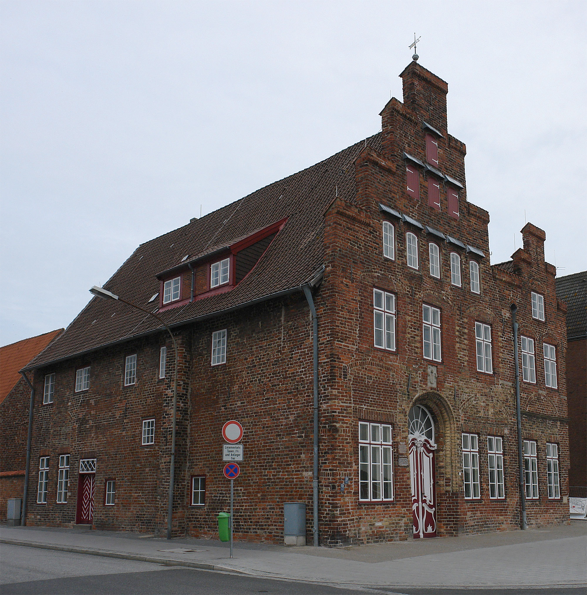
| | | | By 1901 when he wrote the novel, Strandkörbe were so quintessentially a part of German beach life--as they remain today--that Mann understandably made this, and another, reference to them in this novel. But the problem is that the scene is set in the 1840’s and Strandkörbe weren’t invented until 1882, so both references are, unfortunately, anachronistic. I suppose, since they were so common, and such a part of normal beach life, Mann assumed they’d “been around forever” and didn’t realize they were only nineteen years old at the time. | | | | PROMENADES & VORDERREIHE I continued south along the Strandpromenade to its end at the river, and, before turning right on the Travepromenade into town, I turned left out onto the mole that formed a breakwater on the north side of the river. On the beach side of the breakwater there were swans, and I’d never seen swans in salt water before. There was a small light at the end, and good views back, similar to this picture of the Trave entering the Baltic. We are looking inland (westward). The Baltic is in the foreground, and the Strandkörbe are visible on the beach, with the Strandpromenade behind the beach. Most striking is how outsized the Maritim looks as compared to everything in town around it, including the dwarfed Alter Leuchtturm and the center of town in the near distance. The breakwater is to the left, and, across the Trave, is the Passat, docked next to the lush Priwall Peninsula. | | | | This northward view shows the beach better. Other, low-level resort hotels are beyond the Maritim, and, if you click to enlarge, you might be able to see the color-coding of the Strandkörbe belonging to different concessionaires. You can see how wide the Strandpromenade is, and, where it reaches the river, the road to the right off to the breakwater, and to the left, the narrower Travepromenade into town. | | | | While the Strandpromenade is set back from the Baltic because of the beach, the Travepromenade, as shown in the previous picture, runs directly along the river’s edge up to the Vorderreihe in town. There are cafés and other points of interest all along the way, allowing for a pleasant stroll. There is no through traffic on the Vorderreihe, so cafés and strollers are free to wander on the paving stones. I was pleased to come across a Leierkastenmann / organ grinder, grinding away his tunes. | | | | The Vorderreihe is only a few blocks long. Most of it runs along the river’s edge, except for a few restaurants that are directly on the water. Also near the water is the black-glass, modern (2007) Ostpreußenkai Cruise Terminal. The river’s on the right, and you can see that the fenced-in terminal doesn’t use up too much room. Cruise ships stop here about 20 times a year, or about every 2 ½ weeks. Again, the Scandinavian and Finnish ferries dock in a more commercial area a bit upstream, near the Skandinavienkai rail station. What amazes me is this location. Passenger ships always seem to dock in rather industrial, commercial areas, usually with multiple piers, but ships, like the Deutschland, dock here right at the river’s edge, right at the terminal, and right in the very center of town. It’s so pleasant, and so unusual. | | | | Although Travemünde was founded as a fishing village in 1187, a devastating fire in 1522 destroyed the town. Therefore, the three oldest buildings in town are mid-16C, post-fire. We’ve already seen the Alter Leuchtturm of 1539, and the other two are in the oldest part of town, shown in this view of the last couple of blocks of the Vorderreihe upstream, beyond the cruise terminal. One block inland is the tower of the Sankt-Lorenz-Kirche of 1557. In front of the church, right on the Vorderreihe, is the Lübsche Vogtei of 1551. | | | | LÜBSCHE VOGTEI This building embodies the history of the area right after the feudal, medieval period. Let’s first talk about the name. Lübeck is, to my knowledge, the only city that has a special adjective for it. If it existed in English, it would be something like *Lübeck-ish, or would be *Lübeck-isch in German. But the city’s name loses a syllable in the possible form lübisch, which is usually shortened further to lübsch (the E at the end is a grammatical ending). | | | | To know more, we have to look to the Holy Roman Empire to see what sort of a legal official a Vogt (FOHKT) was. A Vogt was a member of the nobility who served as a magistrate, or a prefect, exerting secular justice, but also assuring protection and security. In this case, the Lübscher Vogt served Lübeck’s interests in the strategically important Travemünde harbor. | | | | The derivation of the word is interesting. The Latin word advocatus is the source for the word for “lawyer” in many languages: FR avocat; IT: avvocato; SP abogado; DU advocaat. English borrowed it as “advocate”, not a lawyer, but someone who’s on your side. And when German borrowed it, it became Vogt. Look at it this way: adVOCaTus to VOCT to VOGT. And the word is more familiar than you may realize, since it has odd and differing spellings when it appears in the name of actor Jon Voight and opera singer Deborah Voigt, both of whom pronounce their names VOIT. | | | | Finally, the office of a Vogt is a Vogtei (stress last syllable, rhymes with “by”). Perhaps a good translation could be “prefecture”, so the Lübsche Vogtei would be the Lübeck Prefecture, or the Office of the Lübeck Prefect. Today the restored and recycled Lübsche Vogtei is used for commercial purposes, with shops and a restaurant inside and a café out on the Vorderreihe. Typical of the Baltic area, it’s made of brick (so are the church and lighthouse), and it’s in the step-roofed Renaissance style, also seen in Dutch buildings of the period. The style is called Backsteinrenaissance / Brick Renaissance (Backstein is literally “baked stone”). | | | | I was done with my walk and started making my way back, when black clouds appeared in the west--a summer storm was on its way. I had noticed a restaurant whose menu I liked on the river next to the Cruise Terminal entrance, and I just made it there when the downpour came. I enjoyed a pleasant meal with a beer, sitting cozily in the restaurant’s glassed-in porch directly on the Trave, and enjoyed watching ships going by. One of them leaving was one of the Finnlines ships on its way to Helsinki, just like my Finnhansa trip in 2006 above from Helsinki to Travemünde. | | | | The sun came out and I made my way back to the Maritim. The next morning, I asked for a late checkout, then made my way back to the terminal in the early afternoon to check in on the Deutschland. Inside, they had the ship’s band playing music while sparkling wine was served. When the ship sailed, it was a strange feeling to be leaving right from the center of town, where people were still sitting in cafés below watching us sail away. | | | | An Anonymous Death From the moment I became aware of the event, I debated whether to include it in this posting. But I finally decided that death is part of life and shouldn’t be hidden away. The event is also demonstrative that sudden, tragic death doesn’t just occur under nefarious circumstances, but can happen on a clear, beautiful day, in a friendly, beautiful place. There is also huge irony in that the death involved the most obvious stand-out location in Travemünde, because of its height. But it added to the tragedy that so few people were aware that it happened, to the point that it can be considered an almost anonymous death. | | | | I would have been absolutely as clueless as everyone else in town if I’d been able to check into my room on arrival. I would also have been just as clueless if I’d waited until after dinner to go back to the hotel, get my bag and room key, and settle in to the room. But I didn’t. When I came back from the breakwater and started walking down the Travepromenade, I figured I was so close to the hotel at that point, in mid-afternoon, that I might as well take care of completing my check-in. So I split my walk in two at about 3 PM, left the Promenade, cut through the café tables, and walked up into the grassy area and parking lot area around the Maritim to go inside. | | | | After a few steps, I came across a group of about 8-10 people, standing around and looking at the hotel. I asked a young man: Was ist passiert? / What happened?, and he told me someone had fallen off a balcony. A woman nearby seemed to know quite a bit more, and she told me a woman had fallen from the 12th floor. I asked: Gefallen oder gesprungen? / Fallen or jumped?, and she said the woman had tried to sit on a balcony railing and had fallen. I never did discover how this woman knew more than the rest of the group. In any case, I then noticed up ahead a couple of police cars and fire rescue trucks. | | | | If someone falls from a height in a city to the sidewalk, there would be an immediate crowd, and the police would cordon off the area. But you’ll recall that the lobby area of the Maritim covers a much larger footprint than the tower, and it was onto its low roof that she had fallen, so that nothing was visible. On the side of the building, no more than maybe a half-dozen people were looking down from their balconies. It was at this point that it struck me that almost no one was aware of what had happened. People were still strolling the Promenades--as I had shortly before when it had happened--or sitting in cafés, unaware. Most people in the hotel were unaware, and the anonymity of the event, compared to the horrific normalcy of the atmosphere, was palpable. I continued to the lobby, got my bag and room key, and went up to the fifth floor. | | | | Whenever I first enter a hotel room, since I’m a “view freak”, the first thing I do is go to the window, or the balcony if there is one, to check out the view. But it struck me that normally, I would probably have gone out onto the balcony and looked into the distance. I would have had no reason to look down to the lobby roof four stories below my fifth-floor room. | | | | But this time I knew to do so. Down below, in the middle of a half-dozen rescue workers, a blanket covered the body from head to knees, but from the splayed legs, I could tell she was lying on her left side. From the slacks and flat shoes she was wearing, I suspected it was a younger woman, probably a teenager. It also occurred that teenagers are young and stupid enough to have less concern about danger and death, and could conceivably try sitting on a high railing. After a while they brought a gurney and carried the body away. There was no trace left on the tarred roof that anything had happened. | | | | I looked at the barrier where I was standing. Up to knee height, it was made of brick. Above that were three horizontal metal bars, one above the other, and she had probably, stupidly, tried to balance herself on the top one on her balcony. | | | | But things were weirder than that. When anyone tries to sit on a fence--on the ground level, of course--to balance yourself, you have to support yourself with your heels, or even just calves, against the lower part of the fence. But the three horizontal bars in this case were set in a graceful inward curve, perhaps at about 30°. Anyone sitting on the top bar would have no support below to maintain balance. This means that, if it had happened as reported, what the young woman did was doubly stupid. And I also blame the architect who’d designed this railing, who’d put style ahead of trying to idiot-proof the thing. | | | | I unpacked my bag, and went back down to the Travepromenade to continue into town, as described, once again surrounded by people who were totally clueless that anything had happened a short distance away in the middle of that otherwise pleasant afternoon. | | | |
| |
|
|
|

