|
Reflections 2012
Series 18
September 23
Atlantic Isles VI: Stavanger - Shetland - Faroes; Norse Expansion III a: Westward
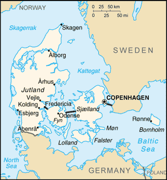
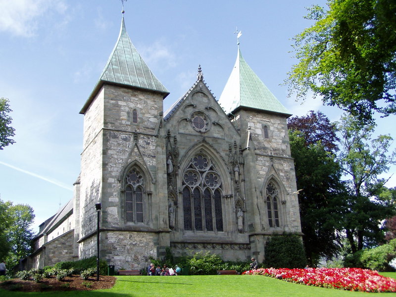
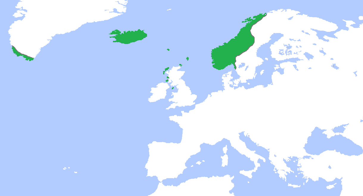
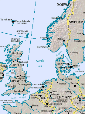
| | Following the Atlantic Isles trip from mid-May through June this year, we’ve so far discussed the eastbound trip, including three islands in the Azores (I & II), Madeira (III), and two islands in the Canaries (IV & V), plus the “continental interlude” in Hamburg and Travemünde, and recently the Deutschland itself. Since the continuation after Travemünde, that is, the westbound trip by ship including Iceland and Greenland, followed very precisely westward Norse expansion, it seemed sensible to first describe other Norse expansion as well, so we discussed the largely Swedish expansion eastward into Russia (I), and after a cultural and language break (Britain, runes) came the largely Danish expansion southwestward to England (II a), as well as to Normandy plus England (II b), to which we also discussed changes to the English language. Since those earlier Atlantic Isles discussions were numbered up to V, this continuation starts with VI. The first two directions the Norse expanded in we’ve numbered I and II, so the westward expansion will be III, starting here with III a, for expansion from Norway to Shetland (also Orkney) and to the Faroes, then later III b for Iceland and III c for Norse Greenland & Vinland. Of all these islands, only the Faroes and Iceland remain Scandinavian today. At any rate, we can now discuss the “Isles” and “Expansion” simultaneously. | | | | Leaving Travemünde After boarding at the terminal in Travemünde, which was so pleasantly located on the riverbank along the main street, full of cafés, we sailed in the late afternoon out the Trave and into the Baltic, north towards Denmark. On this overview map, note the location in dark black of the three bridges that nowadays bring rail and road traffic from continental Europe via the Jutland Peninsula to Copenhagen and on to Sweden. Now on this detailed map, find Lübeck and the unnamed red dot near it for Travemünde. (Also note Kiel; between Kiel and Flensburg is Angeln [unmarked], from where the Angles sailed to Britain.) During the night, we would have sailed between German Fehmarn and Danish Lolland, and up the Danish strait known as the Storebælt / Great Belt between the islands of Fyn / Funen and Sjælland / Zealand (not to be confused with the Dutch province of Zeeland), and under the fabulous bridge, the middle of those three, known as the Storebæltsbroen / Great Belt Bridge. Normally, I’d consider it my duty to get up in the middle of the night to watch our passage, but I didn’t have to this time, since I’ve already done it. In 2006, I took the Color Line’s Color Fantasy overnight from Oslo to Kiel, and then I did get up in the middle of the night to watch us going underneath--it was breathtaking. The next day, after changing ships (I love saying that) in Kiel to the Deutschland on the way to Norway and Spitsbergen, I went under the bridge a second time in two days, and this time I let myself sleep through it, which I also did the third time, coming back from Spitsbergen to Kiel, and this fourth time, fabulous a view as it is. However, I can show a picture of another ship going under the bridge (the “Allure of the Seas”), and also one of the bridge at night, which is how I saw it when the Color Fantasy went under it. | | | | Early the next morning, we sailed from the Kattegat into the Skagerrak around the point known as Skagen, at the northernmost point of Denmark (I remain fascinated about points of land that reach out into the sea). Skagen gave the Skagerrak its name. It was too foggy, and far too early, to see it, but I’ve been to it, and enjoyed seeing it in the past from the Deutschland. | | | | Stavanger We then rounded the large bulge of southwestern Norway, and entered the large Boknafjord, where the city of Stavanger (sta.VANG.er; VANG rhymes with “gong”) lies at its southern end, as shown on this map of Norway (click to enlarge). Also note the fylk / county of Rogaland, of which Stavanger is the administrative center, with Haugesund as the second city, and notice how close Shetland, the next stop on the ship, is. | | | | I must make one comment about our first three stops. Stavanger, the only actual continental, non-island stop once we left, has only one Michelin star in the Scandinavian book and Shetland only one in the UK book. The Faroes aren’t listed by Michelin, but in my experience they would have the same one star. This is perfect. All three are out-of-the way places, ideal for stops on a ship voyage. They are places you wouldn’t visit otherwise, unless you had a particular interest. Once there, they are easily visited. You stroll around for a couple of hours, and still have the rest of the day to relax on the ship. As for Stavanger, I’d been to many places in Norway, but the southwest corner is out-of-the-way, and doesn’t have enough draw to take the train or car all the way out there. A stop from a ship is ideal, since all three places are nevertheless pleasant to visit in their own way. | | | | Stavanger is Norway’s fourth largest city, and in recent years has become a center for the booming offshore oil industry, largely supplanting the fish canning industry, which I mention since it’s significant below. Although it dates back to the early 12C, when its cathedral was completed, it was only late in the 20C with its oil boom that it grew substantially. | | | | I have a bykart that can easily orient the reader to the stroll I took through the town center. What could that Norwegian word be? Test your memory about all the English villages that end in “-by” because of the Scandinavian influence, and you may figure out that a bykart is a town map. Here’s the bykart of Stavanger (click to enlarge), and note that word in the upper left. Follow on the map as I describe the route. | | | | We docked right in the middle of things at Skansekaien (skanse+kai+en = bulwark+quay+the). First look slightly to the right at the drawing of the modern, towered gray building, just as we were able to from the ship. This is the Norsk Oljemuseum / Norwegian Petroleum (Oil) Museum. While I had no interest in it, and assume few if any did, it’s worth mentioning here that oil is a big subject in Stavanger. Now take the five-minute stroll with me on Skansegata (Bulwark Street) down past that brown building along Vågen (VO.gen), (“The Bay”), the inner, and historic harbor, which has almost the same shape and name as the Vågen we discussed in Bergen (2006/5), up the coast. Note Skagenkaien, halfway down Vågen, shown on this picture, with the pedestrian walkway behind the boats. Look left, and you’ll see that brown building. If the ship were in this picture, you’d see it up that street, that’s how close we were docked. | | | | Just beyond the bottom of Vågen to the right, you see the drawing of the two green-roofed towers of the Domkirken (dom+kirk+en = cathedral+church+the)--if you remember “-by” in England, also remember “kirk”--and the lake called Breiavatnet (Breia Water) behind it. The Stavanger Domkirken is Norway’s oldest cathedral, built between 1100 and 1150; Stavanger counts 1125 as its year of foundation. Aside from the two vocabulary items mentioned there are additional links to England. The English bishop Reinald, believed to have been from Winchester, is said to have started the cathedral’s construction in 1100. This cathedral is dedicated to Saint Swithin (also Swithun, Old English Swiþun) who was an Anglo-Saxon bishop of Winchester and patron saint of Winchester Cathedral as well. Another connection is that, walking up a hill from Vågen, the façade one sees is severe Romanesque, but Romanesque in England is referred to as Norman architecture, which was originally the style of the Domkirken, as seen here in its front entrance facing Vågen. But in 1272 a fire ravaged Stavanger and the Domkirkan was heavily damaged, and when it was rebuilt, it was enlarged to the rear with a new choir in Gothic style, a fact that amazes everyone walking around the building, shown here with the two green-roofed towers in the back. | | | | This is the view of the Breiavatnet, with its signature fountain. The low building across the lake on the left is the rail station, where I stopped next. I was very pleased to see a historic steam engine (Photo by Daigaz) on display in the lobby, and noted down its name, Hugin (Photo by Daigaz), as well as the fact that it was made in Motala, Sweden, in 1881 (the canal boat stopped there on the Göta Kanal), and that it had a top speed of 55 km/h (34 mph), both forward and backward! It’s narrow gauge, specifically Cape gauge at 1067 mm (3.5 ft). However, today, all Norwegian rails are standard gauge. In addition, while the rail line to here from Oslo had existed in segments, it was only completed under German occupation in 1944, for military reasons. Stavanger is also expanding its commuter rail. | | | | To simplify following the second half of the walk, I’ll reprint here the bykart. Look at the west side of Vågen at Strandkaien (Beach Quay). The red area above it is the historic district of Gamle Stavanger / Old Stavanger. Note the parallel streets up the hill called Nedre (Lower [“Nether”]) Strandgate and Øvre (Upper [“Over”]) Strandgate. It’s believed that this district contains Europe’s largest collection of wooden buildings, encompassing 173 houses dating from the late 1700’s to early 1800’s. I remember them being white, but from what I can figure out from Norwegian Wikipedia (the native language always has more details), white paint was more expensive, and so the backs of the houses, that no one was to see, were painted red, a typical characteristic of Stavanger wooden houses. I wish I’d known about the red when I was there, since I don’t know if I noticed. The houses had been working-class structures, owned by workers in the canning factories. With the decline of that industry, the neighborhood became derelict, and people wanted to tear the houses down. But they were restored and preserved, are now expensive, and Gamle Stavanger is now a very trendy neighborhood. Up on the hill, cobbled Øvre Strandgate is the prettiest street. | | | | We can end with this aerial view of Stavanger. Reorient yourself, since the view is to the southwest, and the ship would have been docked off the picture to the lower right. You can see almost all of Vågen, and over to the Breiavatnet fountain (the Domkirkan would be just off the picture to the left). But to the right, note how leafy Gamle Stavanger is with its wooden houses. Looking at Vågen, we can finally discuss the name of the city. The Old Norse form of the name was Stafangr, and most people believe it was actually the original name for the inlet now called Vågen, and the name spread from there. There are two explanations for the first element, which would have been stafr. It means “staff” and could refer to the shape of the inlet, or could be a reference to a nearby mountain. But it’s the last element, angr that really struck me. It does mean, quite logically, “cove, inlet, bay”, but it’s another of those several connections I found between the first and second halves of this trip. The capital of Terceira (2012/7) in the Azores is also Angra (do Heroismo), which means “cove”, so what goes around, comes around. | | | | Norse Expansion Westward We can now blend our discussion of Norse Expansion with the Atlantic Isles trip. In my opinion, Deilmann dropped the ball in not including this topic as part of the voyage. They called it “Ewiges Feuer und Eis” (Eternal Fire and Ice), a reference to the volcanoes and glaciers of Iceland and the Greenland Icecap and icebergs. To that geographic point of view, which I love, they did not add any historic point of view of the Norse, and I think that was a loss, especially since the trip was westbound, in the direction of settlement. I met someone on board named Mark who, with some of his friends, were also interested in the Norse history of Greenland, but nothing had been officially organized to visit any former Norse sites. Fortunately, I’d researched what I needed to know in advance, and will include it here. | | | | For the last time, I’ll repeat here the centuries-by-color map and the date-and-route map of Norse Expansion. On this latter map, note the importance of the town of Avaldnes in Norway at this time, which we’ll discuss in a moment. Also note the sequence from Norway to nearby Shetland, later to Orkney below it, and the Faroes, then to Iceland, then Greenland, (and ultimately, Vinland). Norse Expansion westward was like stringing beads on a necklace, one after the other. Why didn’t Deilmann take advantage of this route and include that history in their theme? Perhaps history is too academic. Everyone understands an iceberg. | | | | We should also repeat our map of Germanic languages in the early 10C. Again, Old Norse is shown in its two major dialects, orange for Old East Norse, which became Swedish and Danish, and red for Old West Norse, which became Norwegian, Faroese, and Icelandic, plus two extinct ones, one in Shetland and Orkney and one in Greenland. Finally, to show again that the westward expansion of the Norse was a Norwegian affair, we have a new map, showing the Norwegian Kingdom c 1265, at its greatest extent. From mainland Norway we again have Shetland, Orkney (plus a bit more in Scotland), the Faroes, Iceland, and even the three settlements in Greenland, from which Vinland (Newfoundland) was tentatively explored, but never settled. This is the story we shall tell.
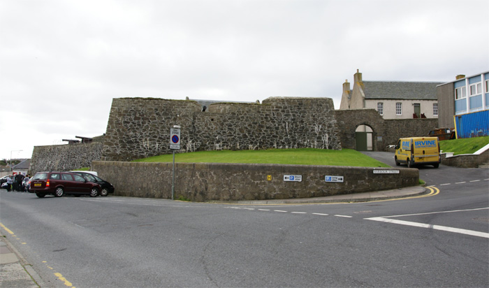
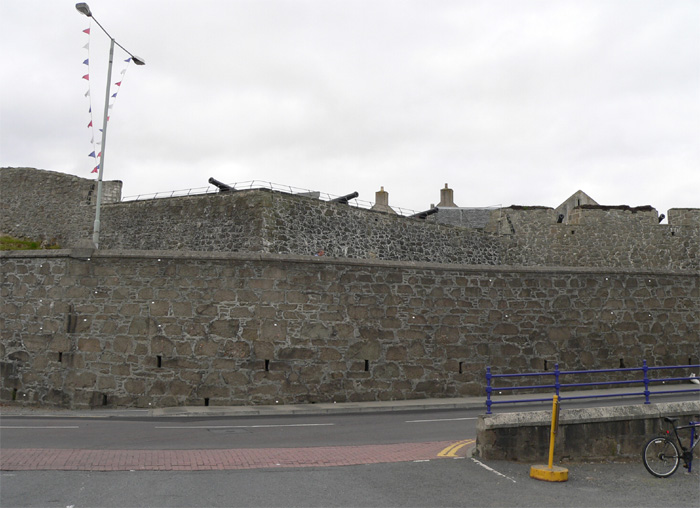
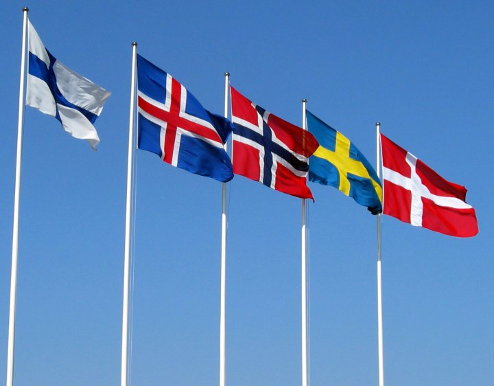
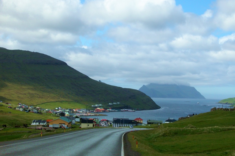
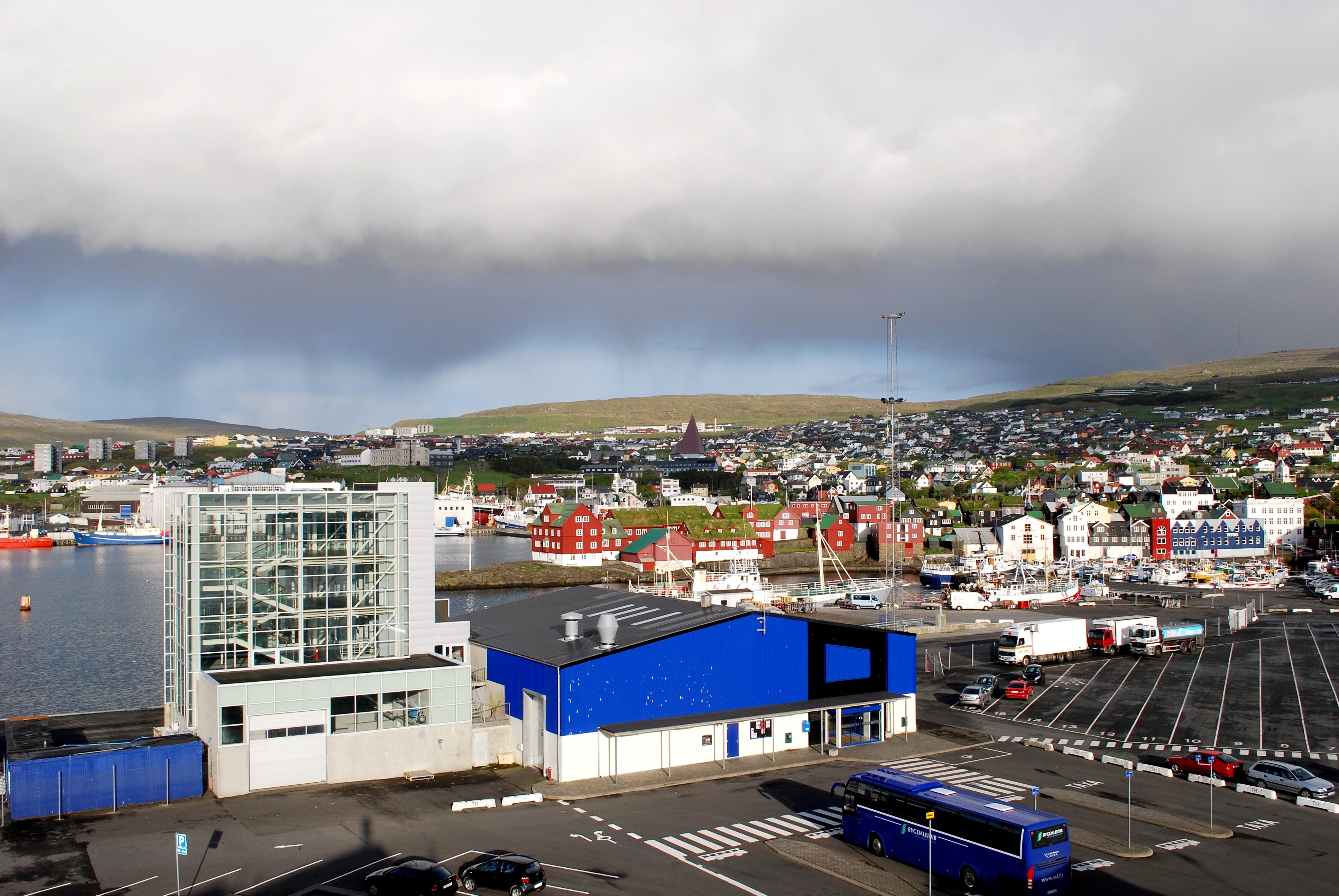
| | | | Colonization Norse expansion westward didn’t involve invasions but instead colonization and settlement. We’ll mention just a brief overview as a follow-up to the maps. | | | | The NORTHERN ISLES (SHETLAND & ORKNEY), in Old Norse Norðreyjar, although they’d been inhabited since Neolithic times, were colonized by Norwegians in the late 700’s and 800’s. Old Norse there developed into the now extinct Scandinavian language called Norn. Norwegian King Harald Fairhair (Old Norse Hárfagri, Norwegian Hårfagre) annexed both island groups in 875. Remember Sir Walter Scott’s poem about him and the “Norsemen” in 2012/12. | | | | The FAROES had been settled by Gaelic hermits and monks in the 6C who introduced the Irish language, but the Norse arrived in 850. Old Norse there became the Faroese language. | | | | ICELAND was settled in 874, and the Icelandic Age of Settlement is considered to have lasted from then until 930, when the Alþingi, still Iceland’s current Parliament, and one of the oldest parliaments in the world, was founded at þingvellir. Old Norse in Iceland became today’s Icelandic. (If you are still thorn-deficient and edh-deficient, please review them, because they’ll be coming up regularly. Simplified rule of thumb: they’re both TH.) | | | | GREENLAND saw Norse colonists arrive on the southern stretch of its west coast starting in 986. The three colonies there lasted almost five centuries before dying out, so that the language that developed there from Old Norse, called Greenlandic Norse, is now extinct. | | | | VINLAND (NEWFOUNDLAND) was just a brief, non-stable settlement at the northern tip of Newfoundland’s Northern Peninsula that lasted just two or three years centering around the year 1000. The rediscovered archaeological site there is located at L’Anse aux Meadows (pronounced, rather amazingly, “Lancy Meadows”). | | | | In sum, only the first four above were Norse colonies, and the Northern Isles are now Scottish and the Greenland colony is gone, making two languages extinct, so the Faroes and Iceland, and their languages, are what remain Scandinavian. We’ll expand on the above colonization as needed at each location, and the story gets more interesting the further west one gets, somewhat in Iceland, and particularly in Greenland and Vinland, so there’s a lot more coming in subsequent postings. | | | | Personalities Name a famous Viking, or better yet, two, that most people have heard of. (We won’t include William the Conqueror, since he’s too remote in time, and even Rollo isn’t that well known outside those that study Normandy.) Hint: the two are related. | | | | Probably most people have heard of Erik the Red and Leif Ericson. Possibly, most people didn’t know they were father and son, even despite Leif’s patronym Ericson (despite the K/C spelling difference, which only appears in English). This is a major problem about the old Scandinavian patronym system, which existed without family names. How can you easily know of a family with no family name? | | | | As a matter of fact, we have three generations of that family to talk about. Most of this will involve discussions later on from Iceland to Greenland to Vinland, but we can set the scene now, in this easy-to-remember manner: There was Grampa, Pop (Erik the Red), and Golden Boy (Leif Ericson) who had two brothers and a sister. Not all were of admirable character. | | | | “Grampa” in this family was Þorvald Asvaldsson (you can tell what his father’s name was from his patronym). The story starts off in a negative light, since Þorvald was considered an outlaw, having been exiled from Norway because he’d committed manslaughter. He sailed c 960 with his family, and settled in the northwesternmost peninsula of Iceland. He died before 980. | | | | “Pop” was his son, Erik Thorvaldsson (Old Norse: Eirikr þorvaldsson) 950 - c 1003. Probably because he had red hair, he was called Erik the Red (Eirikr hinn rauði). He was born in Norway, but left when his father took the family with him in exile to Iceland. He would have been about 10. Later in life, Erik was credited, not with discovering Greenland, but with founding the first permanent colony there. He, however, is not only considered an explorer, but also an outlaw like his father, because he had to leave Iceland--for Greenland--in exile for three years, following in the family “tradition” of committing manslaughter, not one instance, but several. Erik died at home in Greenland. | | | | “Golden Boy” was Erik’s son, Leif Ericson (rhymes with “safe”; please don’t turn him into a leaf). Leif is the family member in whose name statues are erected and stamps issued, since he’s an Icelandic explorer, having been born in the family home in northwestern Iceland. In Old Norse he’s Leifr Eiriksson; in Icelandic Leifur Eiriksson. I’ll mention his date, too, c 970 to c 1020, to show we’re centering ourselves around the millennium, since he’s considered to be the first European to land in North America--excluding Greenland. However, like Erik and Greenland, Leif was not the first one to sight what Leif called Vinland. Leif died back in Greenland, like his father. | | | | Leif had two brothers and a sister. Þorvald Eiriksson, apparently named after Grampa, went to Vinland on a later trip than Leif’s and was killed there by locals. Þorstein Eiriksson, the youngest brother, went to retrieve his body, got lost and never made it, and fell ill and died upon returning home to Greenland. Both brothers were apparently honorable men, like Leif. The best thing that can be said about their sister, Freydis Eiriksdottir, is that she was a strong-willed woman. She went to Vinland on a later expedition and, according to one saga, intervened in a battle with locals, but according to another saga, the story was very different, and Freydis was apparently a “piece of work”, since she murdered two associates and others out of greed. She apparently wanted to augment the family “tradition” of being in trouble with the law. So, of the six people discussed in this family, the three brothers were honorable, and the others we would consider black sheep. | | | | We will discuss all this in the appropriate locations, but now, we’re still in Stavanger, and should make the appropriate connection there. I thought that Deilmann had made a clever choice in stopping in Norway on the way to the islands, since it seemed to draw the historic colonization connection they weren’t talking about out loud. But when I checked Erik the Red’s background before the trip, I was very pleasantly surprised. I found that it’s believed that Erik was born in the Jæren district of Rogaland. This meant nothing to me until I looked it up. You will recall that when we saw the map of Norway above, I said to note that Stavanger is in the county of Rogaland. This map is just of Rogaland itself (click to enlarge). Rogaland has four districts, south to north, and the second one from the south is Jæren, and includes the southern coastline of the Boknafjord, with Stavanger as its largest town! The local rail service out of the station I visited is Jæren Commuter Rail, and is shown on the map. I was amazed at the proximity of Erik to Stavanger, and it got better. I looked up Erik in the Norwegian Wikipedia, which went a step further with more information, and suggested Erik might be from Sola (on the map). Sola, as it turns out, is not only 11 km (6.9 mi) southwest of Stavanger, it’s the location of Stavanger International Airport, with symbolic connections everywhere, including westward where Erik and his family went. | | | | Remember on the historic map we pointed out that the only town shown on the Boknafjord was Avaldsnes, on the north side. Avaldsnes (nes=nose; rhymes with “lace”; and means a promontory of land) was an ancient center of power on the west coast of Norway. The shipping lane is forced into a narrow passage just by Avaldsnes, and it’s probably the shipping traffic that generated power and riches through the ages. King Harald Fairhair chose Avaldsnes for his main royal estate in about 870, making it the oldest royal seat in Norway. Now look again at this last map of Rogaland. Google Maps shows the current town of Avaldsnes lying halfway between Kopervik and Haugasund. Although no one can know where Erik’s father and his family sailed from, Avaldsnes is a very good candidate. Finally, on the map, look north of Haugasund into the next county and note the town of Leirvik, which we’ll mention again below. | | | | Shetland Sailing from Stavanger, it wasn’t very far to Shetland (with adjacent Orkney), and then afterward to the Faroes. We were crossing between the Norwegian Sea to the north and the North Sea to the south, and were in “oil country”, as is shown by this map of the Exclusive Economic Zones affecting oil production. Norway’s area is in blue--and we pointed out how Stavanger is deeply involved--and the UK’s area is in green, with Shetland and Orkney prominently located there. | | | | Each of the two archipelagos has a number of islands, for which reason, people often talk about “the Shetlands” and “the Orkneys”, but that is disparaged by locals, who refer to simply Shetland and Orkney. The largest island of Shetland, where Lerwick is located, is called simply Mainland, and Orkney also calls its largest island Mainland. The two groups together are called the Northern Isles, with Orkney only 16 km (10 mi) from the Scottish mainland, and Shetland 96 km (60 mi) north of Orkney. The two island groups are apparently very similar--I know history treats them as twins--so I’m glad we stopped at the more remote of the pair. | | | | The islands that comprise Shetland (click to enlarge) are laid out in such a linear fashion that nowhere in Shetland is more than 5 km (3 mi) from the sea, adding to its nautical atmosphere. On the map, locate the yellow dot toward the north end of Mainland for the Sullom Voe Oil Terminal, then note the southern peninsula that is particularly rich in prehistoric finds dating back to the early Stone Age. Shetland has over 5,000 such archeological sites all told. Since we are far enough north here (and in subsequent islands) so that the landscape is subarctic and is virtually treeless, the practice of building in stone has a long history, and is very evident in the capital, Lerwick. Find it on the map and note how its harbor/harbour is protected by Bressay, one of the other larger islands; between the two is Bressay Sound. | | | | While it’s uncertain what happened to the indigenous population descended from the Neolithic period, Shetland was colonized by Norwegians in the late 700’s and 800’s, starting after the aforementioned Norwegian king Harold Fairhair took control of Norway, causing many of his opponents to flee, some to the Northern Isles. From there, they continued to raid Norway, prompting the king to raise a fleet and invade and take over both island groups, annexing them in 875 and making them a province of Norway. | | | | The interesting story of how Shetland and Orkney became Scottish I was pleased to first find out in quite a pleasant manner, when visiting the Lerwick Town Hall (below), and looking at its stained glass windows (discoveries like this are one of the delights of travel), but I’ll tell the history here. | | | | In 1397, Norway joined the other Scandinavian countries in the Kalmar Union, which didn’t involve giving up sovereignty or independence, but left each one less than fully autonomous, and in time, Norway became increasingly under Danish control. So, when King Christian I of Denmark and Norway was having financial problems, that affected Norway. | | | | Christian’s daughter Margaret became engaged to James III of Scotland in 1468, and Christian didn’t have the funds to pay the required dowry. Apparently without knowledge of the Riksråd, the equivalent of the Privy Council, he entered into a commercial contract with James in 1468 in which he pawned his personal interests in Shetland and Orkney as a promise to pay the dowry, and included a clause in the contract which gave Christian or his successors the right to redeem the islands for a fixed sum in gold and silver. However, the money was never paid, and the islands passed to Scotland, which annexed them. Looked at with modern eyes, this type of transfer of land (and people) by means of a failed pawning deal is truly incredible. Of course, I’m sure the Riksråd and other Norwegians were less than pleased as well. | | | | There was also an obligation in the pawning document to retain the language and laws of Norway on these island groups, which obviously didn’t happen. Old Norse in Shetland and Orkney had developed into the Scandinavian language called Norn, which did live on nevertheless. By the 15C, both island groups were bilingual, but Scots had superseded Norn as the language of prestige (compare with Norman French and Anglo-Saxon in England). The language changeover was slow. Most island natives likely spoke Norn as a first language until the late 16C on Orkney and early-to-mid 17C on Shetland. It isn’t known just when Norn, in constant decline, finally became extinct, but it remained stronger in Shetland than in Orkney. The language was really dying out in the late 18C, although some speakers were still alive into the 19C. I understand that, in addition to place names, bits and pieces of Norn remain, such as for local plants, animals, weather, mood, and fishing vocabulary. | | | | This is a map of the languages of Scotland c 1400, based on place name evidence. Blue, largely in the Scottish Highlands, is Scottish Gaelic (Celtic), which had been brought from Ireland as an extension of Irish Gaelic. Yellow, largely in the Scottish Lowlands, is Scots English (West Germanic). Orange, on Shetland and Orkney is Norn (North Germanic). | | | | Two related questions, one of which can help answer the other: where does the name Norn come from, and is it an English or Norwegian designation? | | | | Think of the Northern Islands. Norn is a shortened version of “Northern”. Anyway, it HAS to be English, since the language was spoken to the North of Britain, not Norway. | | | | Knowing that there was still Norse influence in place names, it suddenly struck me that Shetland’s capital, Lerwick, looked suspicious. The suffix -wick is common in English names, but could that be our old friend vik, meaning “cove, bay, inlet”, as in Reykjavik, and even New Yor(vi)k? After a bit of checking it certainly was. Lerwick, in Norse and Norn, had been Leirvik, the first part meaning “clay” due to the high concentration of clay in the ground, so Leirvik means Bay of Clay, or Clay Bay. Then to my surprise, it turns out there are two other towns with the name. When we saw that last map of Stavanger above, we pointed out that the next county north had a Leirvik. There is also a Leirvik in the Faroes, which I’ll point out later, so it’s quite a bit of fun that the first three stops on this trip each have a Leirvik/Lerwick, and it’s another thing that links the Northern Islands to their Scandinavian heritage. | | | | Walking around Lerwick I noted down a number of street names with Norse references, such as King Harald Street, King Erik Street, King Haakon Street, and Saint Olaf Street. And also, in addition to vik, we should keep in mind ey (rhymes with “they”), meaning “island”. It also appears as øy, ø, ö, depending on the Scandinavian language. It will be coming up in a number of place names, such as the Icelandic islands of Grimsey, and Surtsey, Iceland’s Westman Islands / Vestmannaeyjar, and everyone’s favorite volcano, Eyjafjallajökull (you, too, will be able to pronounce it when the time comes). But for now, note that ey does appear at the end of Orkney, even though it the name is anglicized to ORK.ni. Also, the island of Bressay we just mentioned was recorded in 1263 in Old Norse as Breiðoy (“broad island”) and by 1410 it was Brusoy. It’s evolved to Bressay, but that is still that Norse/Norn ending. | | | | LERWICK Lerwick, the capital of Shetland, is small, only about 7500 people. Although there are some settlements further north, Lerwick is Scotland’s most northerly town, and, curiously, also its most easterly. The Deutschland pulled in early in the morning and stayed until early evening. The daily bulletin had told us that we would be docking, not right in the center of town (a pier that I saw later was a block from the main street) but at the Holmsgarth Ferry Terminal, a bit north of town. Something similar was to happen in the Faroes, and I still wonder why the closest venue couldn’t have been booked in both these places, since the voyage was planned so far in advance. Nevertheless, like Stavanger, it was just the right size town for spending a few hours in, and still having plenty of time on the ship. On awakening, we were already docked, but I had time for a leisurely breakfast before making my way into town. | | | | This view westward shows Lerwick from Bressay, across Bressay Sound. While I wasn’t on Bressay, when we sailed away at the end of the day we came right by here. From this view, you can get an idea of the size of the town, but it’s even more helpful to show the subarctic landscape. You see no trees, but the hillsides are lush green, which was also true on later islands, such as the Faroes. It’s a good image to keep in mind. | | | | I always come prepared with town maps, and the ship provided a rudimentary one as well. so I knew exactly where I was going and what I wanted to do. But I hadn’t had an online map for this writeup until I found the oddest thing. It was a website called--I kid you not--Shetlopedia.com (go take a look, if you like), and it’s a much abbreviated version of Wikipedia, and looks just like it, but deals exclusively with the Shetlands. Its Lerwick page has this excellent map of Lerwick, so you can once again take the walk with me. Note first Lerwick’s coat of arms in the upper right, with a Viking longboat. | | | | Note the docking area in the center of town, then find Holmsgarth up the coast, where we were. It was a twenty-minute walk into town, but that turned out to be unnecessary. When I got into town and spoke to others from the ship, they told me there was a shuttle bus. When I complained later at the Reception desk, they said the town had provided the bus, rather than the ship arranging for it. Still, that was no excuse for not making it clearer that one was available. Once in town, I didn’t know where to get it to go back, so I walked again. Well, I could use the exercise. | | | | The walk from Holmsgarth goes through a commercial area before turning south and dividing, so that traffic is diverted down Esplanade, where the piers are, and so that Commercial Street, the main business street of Lerwick, is left nowadays as a pedestrian zone for all but the far south end. Note the route of Commercial Street, and also Fort Charlotte and the Town Hall near it. | | | | Approaching Fort Charlotte from the north, just before the divide in the road, one sees how modest it is, which makes it so pleasant. It’s a five-sided artillery fort, with bastions on each corner, as shown. Continuing along its west side you can see it’s not more than the equivalent of one or two stories above ground. It used to be on the water but due to land reclamation, it’s now set back a bit from the water. Fort Charlotte reminded me of my hotel in the Forte de Santa Cruz (1567) in Horta, in the Azores (2012/6), which was of similar height, also with bastions, and also no longer on the water. However, Fort Charlotte was built a century later, in 1665, to protect Lerwick from battles with the Dutch. Turning around its south side, and a half-block up a hill (everything to the west of the main street goes up narrow lanes on a hillside) was the South Gate, the main entrance. I remember reading that historic marker on the gate, and enjoying the fact that the fort was rebuilt in its present form in 1781 during the American War of Independence, as part of Britain’s military buildup, but it wasn’t in service long, and never saw any more action, since the Treaty of Versailles in 1783 ended those hostilities. While the battery of guns faces the sound, the other sides were never really completed. The fort was named after George III’s queen, Queen Charlotte, and I saw parallels to Florida. As discussed most recently in 2011/17, for two decades, 1763-1783, Florida was British--that was also ended by the above Treaty of Versailles--but I mentioned at that time Florida names of British origin, such as Hillsborough County and River, and the Saint John’s River, but I could have included the fact that in 1775, Charlotte Harbor, and later the town of Port Charlotte, and even all of Charlotte County, were named after the same Queen Charlotte as this fort whose plaque I stood there reading. So much history is interconnected. | | | | Entering through the gate, I saw that the fort was really today little more than a grassy park (note entrance gate on left), but with a nice view of Lerwick. Note all around the harbor/harbour at the stone buildings, as mentioned earlier. Note also Harry’s Department Store in this picture, which bothered me before the trip as ruining this picture. | | | | But starting down Commercial Street (fort at right), I came across Harry’s again, and it seemed like an old friend, so I went in. It wasn’t the type of store you go in when sightseeing, but I was glad I did. It’s located in several older commercial buildings with small rooms, and there was a room of everyday pottery here, one with hardware there, clothes somewhere else. It’s normalcy in a small town on a remote island is what gave it interest. There was a sign inside that they had the best department store selection in all of Shetland, and who could doubt it? I actually wonder if any other town at all has a department store, and can Lerwick even have another one? The small-town charm of Harry’s remains with me, and its sign doesn’t ruin any pictures at all--it adds to them. | | | | But the prettier part of Commercial Street came beyond Harry’s. All buildings were of beautiful stone, and note how charmingly narrow the street is. No wonder they no longer allow traffic. It was a very pleasant stroll, past Victorian banks and other shops. I stopped in a bookstore, as usual, to browse. | | | | Finally, I went uphill on one of those side lanes leading west to the Lerwick Town Hall. It’s not an ancient building, but Victorian, completed in 1884 during an expansion of Lerwick westward due to the wealth brought by the herring industry (fishing preceded oil here in importance, just like in Stavanger). The building is nice enough, but I wouldn’t have thought to have gone inside if Michelin hadn’t urged me to. On the picture, you only see the left half of the building, but one flight up is a large ballroom the width of the building, with attractive Victorian stained glass windows (1883), which you can see in the picture. | | | | The windows from inside were both attractive and highly informative, giving the history of the Northern Islands. One, for instance, showed the 870 landing of the Norse in Shetland, but the one that interested me showed the marriage of Christian I of Denmark and Norway’s daughter, Margaret, to James III of Scotland, which is where I first learned the whole story of the dowry. All the captions around the room were both in English and Norwegian, and it was here that I first learned of the local appreciation of the Norse heritage. At the end of the room was a huge rose window. Lerwick’s arms were in the center, surrounded by the arms of Denmark, Norway, Sweden, Iceland, Orkney, plus many cities. The more I saw, the more I felt Shetland and Orkney being emotionally drawn to Norway. | | | | NORDIC CROSS FLAG That emotional draw is perpetuated by the Nordic Cross Flag. All Scandinavian countries have essentially the same flag, a horizontal cross on a solid background in a second color (sometimes the cross is outlined in a third color). The flags differ only in the selection of colors. However, since the Inuit majority in Greenland is weaning Greenland away from any remaining Scandinavian influence, wanting to identify with North America and not Europe, Greenland has a very different flag, all of which will be discussed in due time. These are five of the most frequently seen flags: from the right, the flags of Denmark, Sweden, Norway, Iceland, and Finland. Two crosses are outlined and three are not. Finland, of course, is not Scandinavian, being ethnically associated with Estonians and the Sami (Lapplanders), but about 10% of Finns are ethnic Swedes, and there’s a long historic association with Sweden, so its flag gets included. | | | | While those flags are the ones more commonly seen, that isn’t all of them. This is the complete set of Nordic Cross Flags (Image by Endrick Shellycoat). On the lower right is the flag of the Åland (O.land) Islands between Sweden and Finland, ethnically Swedish, but belonging to Finland, followed by, counterclockwise on the continent, those of Finland, Sweden, Norway, and Denmark. Way on the left is the flag of Iceland, followed by, clockwise on the islands, those of the Faroes (white background), Shetland (blue background), and Orkney (red background). These flags uniting those areas of Scandinavian tradition were evident in the stained glass windows in the Lerwick Town Hall, demonstrating the emotional pull of Shetland and Orkney to their history. | | | | Faroe Islands It was again just one overnight from Shetland to the Faroes, and we woke up the next morning docked. We’d been warned in the daily bulletin that, once again, we wouldn’t be right in town in the capital of Tórshavn, that another ship had taken that spot (!!!), but as it turned out, we not only still got to see everything, but we experienced even more from this more distant location. But first some background review. | | | | It was Scottish and Irish hermits and monks who came to the Faroes in the 6C, but by c 850, the Norse arrived. The Faroes have been under Danish control since 1388, and after changes in Scandinavian governments in 1814, the Faroes, Iceland and Greenland remained Danish possessions. Iceland became independent in 1918, leaving the Faroes and Greenland to this day still joined to Denmark as part of the commonwealth known as the Danske Rige, or Danish Realm. Note that the Faroes and Denmark are significantly enlarged to be shown in comparison with Greenland. The populations (2011) are also askew, since Denmark has 5.6 million, and the Faroes only 49,000 and Greenland only 58,000. However, the Faroes were granted home rule in 1948 and Greenland in 1979. Extensive powers have been devolved to them; they have their own governments and legislatures and are effectively self-governing domestically. Yet changes are afoot in both areas, and the Faroese are about evenly split between those wanting the status quo and those favoring complete independence from Denmark. Greenland is also asserting itself, and independence might be near. | | | | Old West Norse, which became Norwegian, Icelandic, and the extinct Norn, in the Faroes has evolved into Faroese, which is probably the Germanic language with the fewest speakers--there are about 50,000 speakers in the Faroes and about 25,000 Faroese living in Denmark and elsewhere. It is thought that Norn was mutually intelligible with Faroese. The closest existing relative to Faroese is Icelandic. They are not mutually intelligible in speech, but the written languages resemble each other quite closely, reminding one of the situation between Spanish and Portuguese. While Icelandic uses both thorn (þ) and eth (ð), and in their traditional uses, Faroese does use ð, but for quite different purposes. While Faroese is the main language of the islands, both it and Danish are official. In contrast, Danish was recently dropped in Greenland as an official language, in favor of Greenlandic. | | | | This is a map of the Faroe Islands (click to enlarge). Note that the word for “island” that we mentioned ey, appears in the Faroes as oy, which is how most of the names of the islands end, such as the largest island, Streymoy. Note Tórshavn, the capital and largest town, at its eastern end. Careful analysis might lead you to think it means Thor’s Harbor--and it does, but it’s misleading. It’s probably not named after the Norse god of thunder and lightening, even though the town’s coat of arms make that reference. It is most likely named after the first settler in the area, whose name happened to be Thor. | | | | Look north of Tórshavn to the next island, and you’ll find Leirvik, with the same name as Leirvik in Norway and with Shetland’s Lerwick being a modified form of it. Then look over to the west and find the airport, which is quite a distance from Tórshavn. And thereby hangs a tale. | | | | We talk often of routes, including transatlantic routes, and we should pay respect to WWII air routes across the Atlantic. In the Azores, on Terceira, we mentioned Monte Brasil in the harbor of Angra with remnants of British antiaircraft emplacements, but we also mention the airport I arrived at, Lajes, which the British built in 1943 and the US expanded in 1944. Although it still has military use, it’s now the island airport. Yet it’s diagonally across the island from the main town, and the reason is that it wasn’t built to be convenient to the town, it was built for military purposes, as a stopover on a central Atlantic route. In a similar manner, and even more spectacularly, a series of airports was built, some by the UK, some by the US, across the northern Atlantic route for contact between North America and Europe. It’s actually thrilling to consider that we’re talking about the Norse sea route westward a millennium ago, while here we have a 20C air route coming back. | | | | The airport in the Faroes was built by the British Royal Engineers during WWII over on the island of Vágar because it was hard to see from the surrounding waters and from any potential German warship. After the war, it was converted to civilian use, but, like Lajes, it’s original purpose was military, and that’s why it’s out of the way today. But this is typical of the airports built on this air route, and we’ll discuss pertinent ones as we get to them. But to complete the thought now: Reykjavik airport (which I have used in the past) in Iceland was built during the war right at the edge of town by the UK. The town has since grown and surrounded it, and it’s in the way. At the moment it’s only for domestic service and service to Greenland, and consideration is being given to closing it, in favor of Keflavik airport, inconveniently 50 minutes away by road, where the international traffic is today, and which was built by the US during the war. I flew home this trip from Keflavik. | | | | Greenland has two airports large enough for international traffic. We drove past the one in Kangerlussuaq (you’ll get used to Greenlandic names later--they’re really not that impossible), built by the US in 1941. The town it’s in of the same name has a population of 556 (!!!). The airport has to de facto serve Nuuk, the capital, but a connecting flight is necessary to reach Nuuk. People are discussing making changes here, too, possibly closing the major airport. In southern Greenland, Narsarsuaq Airport is the other international venue, built by the US in 1941. That town has 158 inhabitants, and the airport is also used primarily as a transfer point to other, smaller ones. In Newfoundland, both Gander and Saint John’s airports were built by Canada just before WWII started, in anticipation of hostilities. Of all the airports mentioned, Saint John’s is the only one conveniently located near a larger city, and good for modern use. | | | | So how did the Faroes solve the problem of its distant airport? It was solved by an umbrella program to connect the major islands. In 1973, they built the bridge (see map above) between Streymoy and Eysturoy. In 2002, they built the first of two underwater tunnels, this one connecting Streymoy and Vágar, which has the airport, and in 2006 they built the second, connecting Eysturoy and Borðoy. These two tunnels charge a toll, payable at petrol/gas stations. All the other tunnels that have been built through mountains connecting sides of an island, are free. The only two major islands not connected are in the south, and there are fast ferries that connect them to the others. Except for those two southern islands, the other islands are considered to have been connected into a “mainland”, which is just what the Faroese call it--Meginlandið. It’s really quite impressive. Now more than 85% of the Faroese population is accessible by car. | | | | There’s one last thing to check on that map. Trace your way up the large fjord north of Tórshavn and then turn into the second smaller fjord on the left. Sail your ship to the far end, then dock the Deutschland at Kollafjørður, named after the fjord it’s on, which is where it stayed for the day. As said earlier, it seems like a problem, but actually added to the visit. | | | | [Note: it’s easy to see that the Faroese word for “fjord” is “fjørður”. We get our version of the word from Norwegian--no surprise, since it’s the land of fjords. The Old Norse word was “fjörðr”, with that extra R on the end that we’ve noticed in other words. Obviously Norwegian dropped that R, but Faroese not only kept it, it extended it into -UR, as did Icelandic, whose form is “fjörður”, using the alternate Ö spelling for Ø. I am at present amazed to have just found out that “fjord” is related to “port”! D and T are paired voiced/voiceless sounds, and Latinate P changed regularly to Germanic F as in GE “Fisch” vs IT “pesce”, or EN “father” vs FR “père”. So apparently fjord/port joins that list.] | | | | To inspect the area more easily, look at this map of just Streymoy itself (click). The village of Kollafjørður is small, with just about 800 inhabitants, but its hilly, fjord surroundings are beautiful. The ship provided a shuttle bus every half hour all day into Tórshavn, a ride that took about 25 minutes one way, and allowed you to view the countryside. Note on the map that the main road south of Kollafjørður towards Tórshavn goes immediately through one of the spectacular mountain tunnels that have been built, which is 2.8 km (1.7 mi) long. (Also note that the underwater tunnel to the airport on Vágar is not far to the west.) | | | | The following picture is not of Kollafjørður, but is a typical Faroese landscape that looks very similar to it. Typical of all the northern islands we encountered, it’s treeless, but the hills are lush green, as in Shetland, and this fjord could be a twin of the one the Deutschland docked in. | | | | I think the most amazing thing about the ride into town were the sod roofs. This picture shows the Church of Kollafjørður. While I don’t recall seeing this particular building, it does show the fjord in the background, and it does show the type of sod roof I saw from the bus, not everywhere, but maybe on every twentieth house. And these weren’t old, quaint structures, they were sturdy, modern houses. The church view also shows a typical architectural design of Scandinavia, the vertical siding (click) on the church’s walls. In addition, black, as here, is a very typical color of the siding, although red is even more frequent. | | | | I’ve since checked further, to find that a sod roof can also be called a turf roof. I knew it was very typically a Scandinavian “green” roof, but I now learn that the name is misleading. The sod is laid on top of several layers of birch bark, which in turn lie on sloping wooden roof boards. It’s the birch bark that’s the active water-tight element, and actually the advantage of the sod is simply to hold the birch bark in place. One might just as well call it a birch bark roof, but it’s the grass that’s visible, hence the name. An additional advantage of the sod is as insulation, since it makes the roof more draft-proof. And its frequent use in the Faroes was for me a surprise. | | | | Tórshavn The shuttle bus entered Tórshavn (click) from the north. The city is small, with 13,000 inhabitants, although that grows to 19,000 including its urban area. The interesting part of the city is very compact, including the harbor and a very historic and attractive peninsula. Find the harbor, where we would have docked if we’d docked in town. Find the historic peninsula called Tinganes and note how it divides the harbor into west and east, Vestara Vág and Eystara Vág, names that seem to indicate west and east. Note the gray commercial buildings on upper Eystara Vág, and finally note the street running north out of Tinganes called Tinghúsvegur. We will be ready to take our short walk once we look at this aerial view, to see if we still can follow the layout. The view is turned toward the southwest, so that Tinganes (with a lot of green--I wonder why?) is now pointing left out to sea, with Eystara Vág to its left, and Vestara Vág to the right. Note the typical lack of trees, yet the open areas are lushly green. | | | | The following picture I had rejected when reviewing choices before the trip, but now I look at it again as an old friend. As it turns out, it shows the Tórshavn Harbor Ferry Terminal, which were those gray commercial buildings on the map. As it turns out, it’s also the Bus Terminal, and this is exactly where the shuttle bus from the ship let us off. I even recognize on the picture the bus loading areas where this bus is parked (you can find anything on Wikipedia!). It was at this terminal that I had my first Faroese language encounter. I never pass by maps, and there was a very large town map at the Terminal, with a large red dot showing one’s present location. The dot was labeled “Tú ert her”, and I was thrilled to recognize it as (literally) “Thou art here”. It’s a shame English dropped that form. | | | | Click to enlarge this picture, and take a closer look at Tinganes (again pointing left, out to sea), and you’ll see that, yes, those historic buildings really do have sod roofs, are mostly red, with some black, and the siding is vertical. At the right end of Tinganes, note the long blue building. That’s just one of the colorful buildings I walked by in Eystara Vág, with its marina. | | | | Walking through town around Tinganes (to leave the best for last), I came to the other side of the harbor and Vastara Vág, equally picturesque, again with Tinganes roofs and red siding visible. | | | | We should now talk about Tinganes. “Nes” rhymes with “lace”, and literally means “nose”. We first saw the word in the name of the old town of Avaldsnes near Stavanger. It’s odd how body parts are used for geographic designations. An “arm” can be a body of water, such as the fjord Tracy Arm in Alaska and a neck can be a peninsula, such as Great Neck, Long Island. Well, here a “nose” is the point at the end of the peninsula. “Ting”, means “Parliament”, and we’ll have a long discussion of words like that in Iceland. In any case, Tinganes is Parliament Point, the most historic area of Tórshavn. | | | | The Viking settlers established a number of tings around the Faroes. Most were local, but the main one was established in Tórshavn in 825. They would meet on the flat rocks of Tinganes every summer, since it was the most central place on the islands, although there was no settlement here yet. The parliament today is called the Løgting, and is considered one of the oldest parliaments in the world (we’ll discuss candidates for the oldest further when in Iceland). While there are still government buildings at the tip of Tinganes, the Løgting itself actually has met since 1856 in a wooden structure a couple of blocks north of Tinganes on a street we located before, appropriately called Tinghúsvegur. Can you take that street name apart to see what it means? It would strike me that it’s Parliament House Way, with the typical -UR ending. What do you think? | | | | Here’s an aerial view of Tinganes (click), with the Faroese flag at the historic point. That building at the outermost point is one of the main government buildings, called the Skansapakkhusið. I sat on that white bench in front and watched the harbor. But it was at the inner end of Tinganes that I entered the peninsula, at these charming forked streets leading around a building. Unfortunately, this is a winter picture, so mentally “remove the snow”. When I was there, I had noticed what it said on that shop, a salon, on the lower level and had made a note to mention it. Now, if you click to enlarge, you can read for yourself: Harra Klipping. Charming. | | | | I walked up that upper street to enter Tinganes at its inland (north) end, right past the Dómkirkjan / Cathedral (in the picture above) established in 1788. One immediately finds oneself walking on narrow, cobbled lanes surrounded by sod-roofed houses, many dating from the 16C and 17C. Even though it seems like an open-air museum, these dwellings are still in use today. As one walks off the central street to the sides, one gets a variety of water views such as this view back to the ferry terminal. Leaving to go back to the shuttle bus, I walked down a Tinganes street whose name was easy to figure out, Skipara Hansens Gøta / Skipper Hansen’s Street, an appropriately nautical name for the continuation of the voyage. At the end of the day, we sailed out of our fjord and back past Tórshavn, and then on to Iceland. | | | |
| |
|
|
|

