|
Reflections 2012
Series 21
October 13
Atlantic Isles VII: Iceland
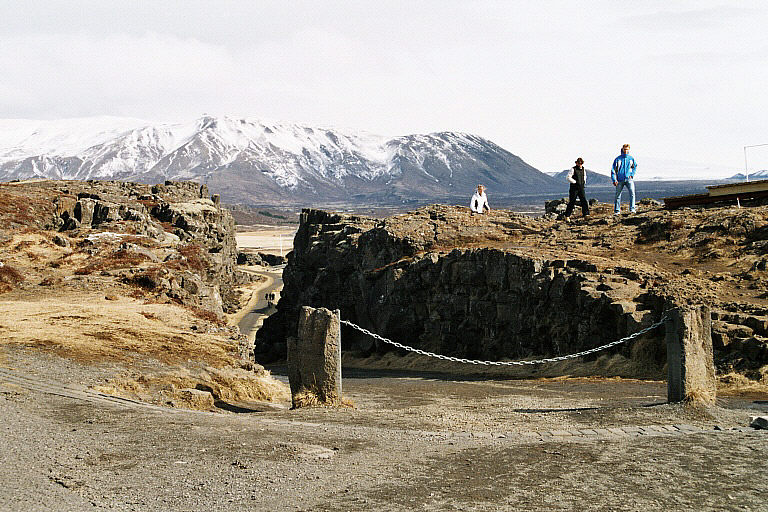
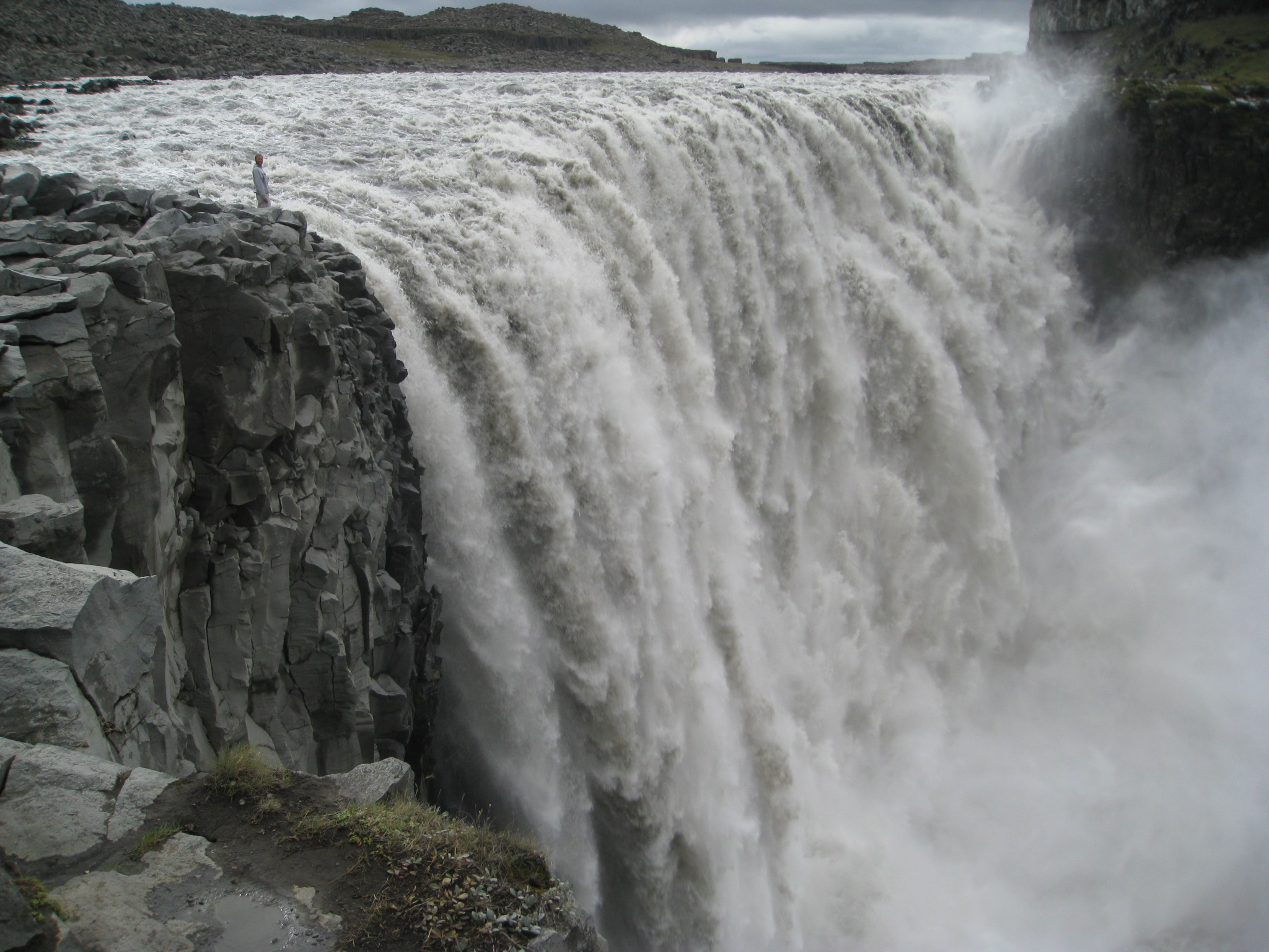
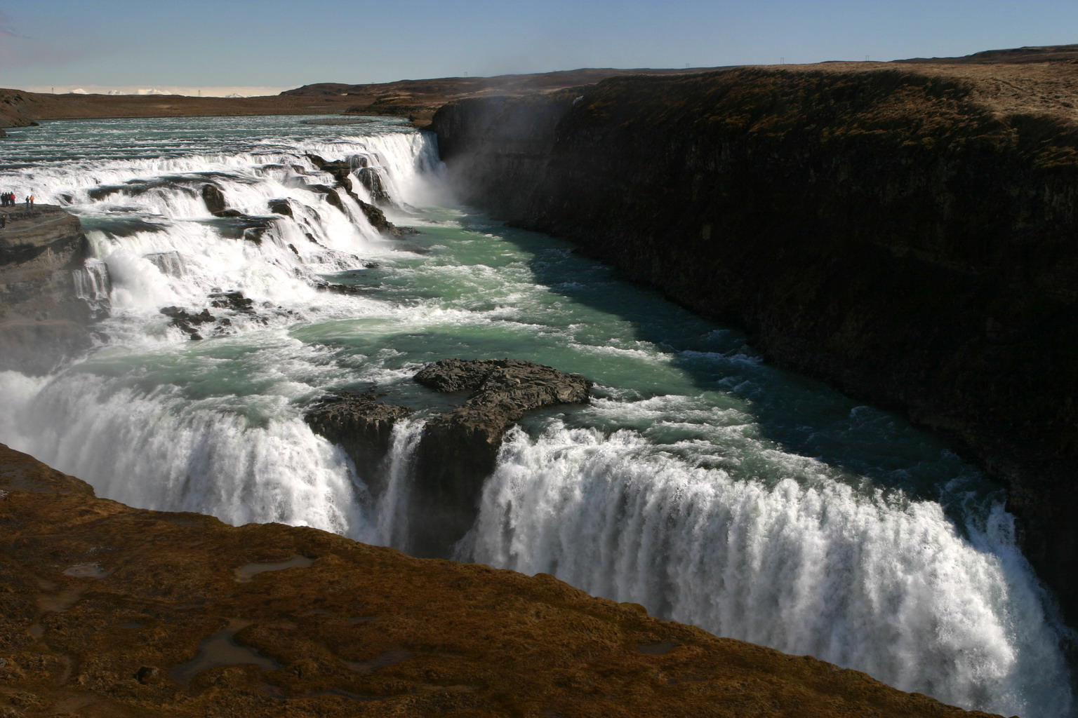
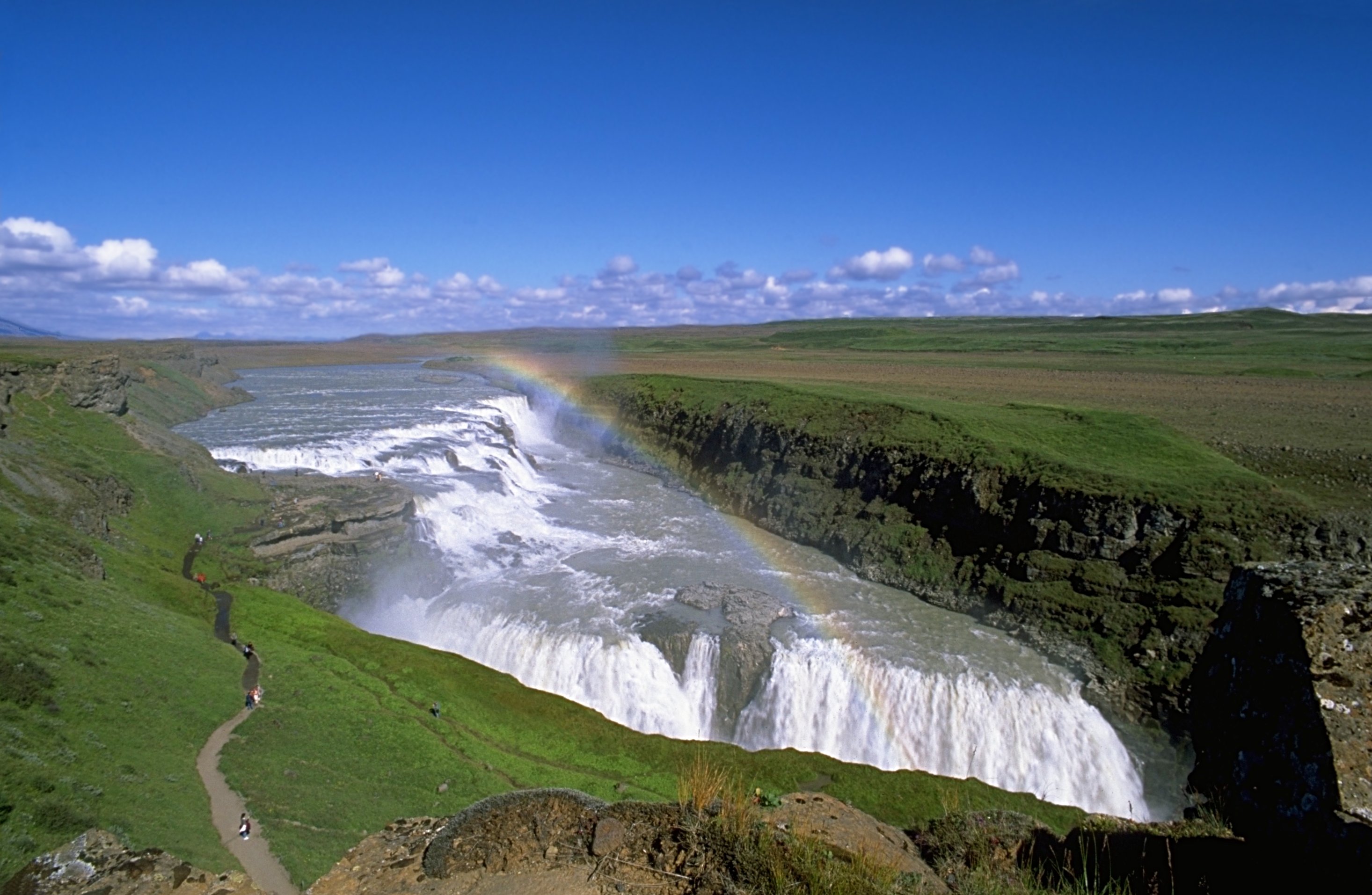
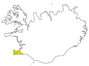
| | Atlantic Isles We continue now the northern segment of the Atlantic Isles trip out of Travemünde to Stavanger, Shetland, and the Faroes, by enjoying a “day at sea” while we take the Deutschland around the southern side of Iceland in the “footsteps” of Garðar and Flóki--but without ravens--past the Westman Islands (already referred to), around the Reykjanes peninsula and into the Faxaflói bay to the Reykjavik area. We awoke the next morning docked, as mentioned earlier, just south of Reykjavik, in the harbor of Hafnafjördur, which quite appropriately, means “Harbor Fjord”. When I first saw that name, I thought I’d never remember it, but once you take it apart and recognize “fjördur” as one of our geographic easy words, remembering “Hafna” is a piece o’ cake. While this map is still handy, we’ll be talking about Þingvellir and other stops just south of Langjökull, then Reykjavik, and then leaving at Keflavik Airport. | | | | This was not my first trip to Iceland, although it was the best. One earlier actual visit was adequate, but there were other stops made there, including my first flight ever, and a “wedding trip”, these last two being at the same time. Explanations are necessary. | | | | Iceland 1962 Icelandair, which I took back from Iceland to Boston this trip, is the result a 1973 merger of two other airlines, one of them having been Loftleiðir. The name was changed to Icelandair in 1979. For decades, Loftleiðir had a great travel deal going for travelers on a budget. They had one of the cheapest transatlantic airfares, all based on the “conceit” that if you stopped in Iceland on the way, and got off the plane, it was two trips, and they weren’t restricted by rules for transatlantic fares. They connected several US cities, notably New York, with Reykjavik (literally, not Keflavik yet at that stage), and their cheapest connection in Europe was Luxemburg. | | | | When our academic year ended at Middlebury’s program at the University of Mainz in early August 1962, since we had planned to get married in Minnesota on the 25th so that Beverly could start her teaching job near New York in early September, we were in a hurry. Although we had sailed to Europe on the Liberté, we decided to cash in our return tickets and fly back, and Loftleiðir was the obvious cheap choice, especially since Luxemburg isn’t too far from Mainz. Beverly had flown before, but my flight from Luxemburg to Reykjavik was my first time in the air ever. | | | | They served us breakfast in a dining room on the ground, then we took my “second” flight ever, not directly to New York, but with a stopover in Gander, Newfoundland for refueling, another sign of the times. In New York, Beverly still had to meet my family over a couple of days before we flew to the wedding in Minneapolis. In any case, that breakfast was my first time in Iceland on that one-way trip. | | | | Iceland 1972 My second time in Iceland was exactly a decade later, in 1972, on the second half of the joint sabbatical year Beverly and I both had. It was the time we studied in various locations, and drove the blue Volkswagen Beetle we bought in Wolfsburg from Vienna to Moscow to Helsinki. By this time, they were using Keflavik for the stopover on the flight to Luxemburg on 18 May, but returning on 5 August, it was Reykjavik on the way to New York. It was on this return trip that we took advantage of a package stayover deal offered by Loftleiðir for two full days. It was probably our own fault for not being well-prepared enough to absorb Iceland, as we allowed ourselves to be shuttled around. The included all-day tour was the standard one to Þingvellir and the other stops, but I hadn’t pre-informed myself enough to be impressed sufficiently. They gave us another tour the next day, through Reykjavik and its area, but I felt disoriented as to where anything was. We also didn’t realize that their own “Loftleiðir” hotel we were put up in was not walkable to the center of town, and we had the feeling of an inadequate and incomplete visit despite all they showed us. All the more reason to fix that in 2012. | | | | Iceland 1986 We’ve attended two conferences in Germany of the American Association of Teachers of German, one in Bonn (where we met and chatted with former Chancellor Kurt Georg Kiesinger) and one in what was then West Berlin in 1986. The West Berlin trip was our last round-trip flight from New York to Europe via Iceland, so when we docked in Hafnarfjördur in 2012, it was my second actual visit, but fourth trip where I was physically in Iceland. | | | | Iceland 2012 This year’s visit to Iceland came in two parts, separated by twelve days in Greenland. Although each part lasted only a day, I was pleased with both days and the weather couldn’t have been more perfect for each of them, joining the two days together into a memorable visit. The first day-stop was during the voyage when the Deutschland docked in Hafnarfjördur for one full day, 15 June, and day excursions were planned. I took the full-day bus trip, similar to the one in 1972, to Þingvellir, Gullfoss, and Geysir, plus a quick stop in Reykjavik. That evening we sailed for Greenland for the twelve days. The ship returned to Hafnarfjördur on 28 June to end the voyage. Instead of then flying home within a couple hours of the morning arrival as most did, I had chosen in advance to book online a night in central Reykjavik for a leisurely visit to, and stroll through, its town center, one of the wisest things I’d planned for the entire six-week Atlantic Isles trip, and then flew out of Keflavik for Boston the next morning instead. | | | | For the sake of continuity, I’ll discuss both days in Iceland at the same time now and will postpone to the next posting describing the trip to Greenland, essentially treating the time in Greenland as a twelve-day side trip out of Iceland, or, to be precise, out of the attractive town of Hafnarfjördur, whose harbor was the hub the Deutschland used for its Icelandic connections. So what follows below is Iceland on 15 June, then jumping to 28 June, and then home to Boston and New York. Greenland is later. | | | | While we’ll see that Greenland can be a bit primitive (though quite modern and contemporary at the same time), like the northern outpost that it is, don’t let Iceland’s name fool you. The only ice you’ll see in the warm weather will be on top of a distant glacier, lending to the atmosphere. Otherwise, Iceland is a contemporary, Scandinavian country, not unlike mainland Scandinavia at all. There are modern, comfortable highways leading through picture-perfect towns, and Reykjavik had one outdoor café after another on the main streets and squares. The only concession to the latitude was a pleasant one. On the second day-visit, even though it was the end of June, the main square was overflowing with lilac bushes at their height of flowering, the late blooming date the only reflection on our northern location. | | | | It was in Reykjavik on the second of the days where I stopped in front of a large street map of the town. Sure enough, once again a large red dot indicated my present location. What had been marked in the Faroes in Faroese as “Tú ert her”, in closely related Icelandic I was told that “Þú ert hér”. Included in the Icelandic version of literally “Thou art here” was of course the perennial thorn. Welcome to Iceland, land of þorn and eð. (Þorn and Eð do sound like a married couple, don’t they?) | | | | Before separating the two days, which will include talking about Reykjavik in detail, for orientation purposes, take a look at this map of Greater Reykjavik, which was the hub of the visit, necessarily, because that’s where 60% of the people in the country live, 201,000, on just over 1% of the land in the country, obviously making it the largest urban area in Iceland. Greater Reykjavik includes, in addition to Reykjavik proper, with 118,000 inhabitants, seven smaller municipalities, including Hafnarfjördur, our “home port” and the third most populous entity in the country (the second most populous is Kópavogur, between the two). While each municipality has its own elected council, the governments cooperate with joint police and fire services, public transport, and the like. Unification of all or some of the municipalities has been discussed. | | | | On the map, note that Reykjavik proper faces north on the south shore of Faxaflói bay. Also note that Highway 1 goes northeast, and when it turns, a purple road branches off, maintaining the northeast direction to Þingvellir, then beyond to Gullfoss waterfall. On the way back on that road is the geyser area, then another stop at Kerið, bringing us back on the lower portion of Highway 1 into Reykjavik. This is the route known to every visitor to Iceland as the Golden Circle, which I’ve now done twice with a tour group, this second time more satisfactorily. (But if I ever go again, I’d rent a car and drive! It’s so easy!) The Golden Circle covers about 300 km (186 mi). Finally, note how Highway 41 goes southwest out onto the Reykjanes peninsula to Keflavik International Airport. | | | | First 2012 Day Visit, 15 June For an organized tour--never my favorite--it was well done. Doris was our Icelandic guide, and spoke German very well. We zipped along the pleasant country roads just described to Þingvellir. | | | | þINGVELLIR If you want to say such an important historical name right, there’s one more item. We know already that LL is TL. In addition, NG is NGK, so that a þing is pronounced THINGK, the Alþingi is the AL.thingk.i, and Þingvellir is THINGK.vet.lir. Keep that in mind, and you’re all set. | | | | It shouldn’t surprise that Þingvellir is a National Park, given its historical, cultural, and, oddly, geological importance, and is also a UNESCO World Heritage Site. The park includes the historical meeting area, as well as a large piece of the rift valley marking the crest of the Mid-Atlantic Ridge, and the south end of the park includes the largest natural lake in Iceland, Þingvallavatn, which can be translated as Thingvellir Water. | | | | We’ve talked about the historic importance of Þingvellir, the “Assembly Fields” or “Parliament Plains”, and how they were used for two weeks each summer starting in 930, and how today’s Alþingi in Reykjavik is a direct descendant of what happened here. Icelanders like to claim that the Alþingi is the oldest parliament in the world still in operation (even though it was abolished in 1800 and not reestablished until 1845), but others contest that. In the Faroes, they bring up that the Løgting was founded in 825, although it, too was not in operation from 1816 to 1852. On the Isle of Man, they claim that Tynwald is over a thousand years old, and in 1979 celebrated its millennium, but there’s no evidence that any assembly was held in 979. And San Marino claims its parliament dates from 301, so it’s really safest to say that Þingvellir is one of the oldest parliaments in the world. | | | | There are many places to visit where there’s “nothing to see”. When you see the Eiffel Tower or the Colosseum, you know you’ve seen something, but when you visit Waterloo, Gettysburg, or Yorktown, you see grassy fields with monuments, but little to understand what happened there unless you come with previous knowledge. It’s the same with Þingvellir, of which we’ll have pictures in a moment. We had a beautiful day, saw the rolling green fields, the valley, the mountains and Langjökull in the distance to the north (that the day was so clear that the glacier was visible at this distance surprised even the guide), but there was “nothing” specific to see beyond the visitor center and explanatory panels at the viewing platform of what the historical meetings were all about. | | | | But the oddity of Þingvellir is that, by pure coincidence, it’s located right at a geological phenomenon, the rift valley where the Mid-Atlantic Ridge surfaces, as we saw on this map in 2012/19. Þingvellir is perhaps a bit further east than shown, but it is on the ridge. If you note, the ridge runs down the Reykjanes peninsula, and at the western end of that peninsula is this bridge we saw in that posting (Photo by Chris 73), which spans the rift “between two continents”. We need another Icelandic word, gjá (pronounced TYA, as in “[wha]T YA [want?]”), which means “rift, gap, fissure, fracture, gorge, ravine”--or use any English word that describes a cleavage of the earth such as this. This bridge, built in 2002, spans what is here called the Álfagjá. Look carefully to confirm that álfa are elves, so this is the Elves’ Gorge. The Álfagjá is just 18 m (60 ft) wide and 6 m (20 ft) deep. | | | | [In a case of cross-referencing of topics, I’m now also researching the Saguenay Fjord in Canada, the subject of a future posting, and have learned in that instance that the (uncapitalized) German word graben, literally “ditch” is used internationally in geology to describe the situation where a fissure has appeared in the earth and the area in between has sunk to form a graben--a ditch. We’ll discuss graben much more in that future posting, but these rifts in Iceland are also examples of them.] | | | | Moving back to considering Þingvellir, we find that the rift is much larger, and that there are side fissures or gorges. I will admit that this had not only confused me in 1972, but I still did not fully understand what I was looking at in 2012. Further reading since has clarified it, and I want to describe it before showing the pictures. | | | | At Þingvellir, the rift itself is a huge graben bounded by major fissures resulting from faults. The rift itself constitutes the valley from the side of which the viewing platform at the visitor center is located, so one stands in “North America” and sees “Europe” way across this valley. As opposed to down where the Álfagjá is not so wide, this huge rift valley varies from about 20-25 km (12-16 mi) wide in the NE to about 10 km (6 mi) in the SW. The valley walls are moving apart at about 7 mm (0.28 in) per year, which, in the past 9000 years has added up to about 70 m (230 ft) of expansion. The floor of this graben (valley) is sinking at about 1 mm (0.04 in) per year, which in 9000 years has added up to a total of about 40 m (131 ft). This means that, in the forty years since I was last here in 1972, the valley has widened by about 2.8 meters/yards and has sunk slightly as well. Funny, I didn’t notice any difference. (!!!) | | | | What had confused me are the parallel fissures on either side of the huge rift, including the one right next to the viewing platform. If you picture breaking open a soft roll, on either side of the split the bread will have fissures, and that’s what these are. The one across the rift valley on the “European” side, that we didn’t get to see, is the Hrafnagjá. If you remember how Flóki found his way to Iceland by using ravens, and that his nickname is Hrafna-Flóki, you’ll see that Hrafnagjá is the Ravens’ Gorge. | | | | The gjá on the “North American” side is called Almannagjá, and we’ll discuss the interesting meaning of that name in a moment. It’s the largest and most famous one. The Almannagjá is spreading at a constant rate of 2 cm (0.79 in) per year. It’s 7.7 km (4.8 mi) long, and at its widest, it’s 64 m (210 ft), with a maximum drop of 30-40 m (98-131 ft). Hrafnagjá is similar. | | | | Now that we have some background, let’s look the Þingvellir area (click to enlarge) from the visitor center overlook (Photo by Hansueli Krapf). As far as the historic meeting area, there’s “nothing to see”. There’s a little chapel in the valley used for weddings, and a few other buildings, but you have to visualize the public meetings and campsites starting in 930. Without background knowledge, it’s far less impressive, beyond the landscape. But now geologically, you’re looking at the rift valley. You can see “Europe” on the other side, while standing in “North America”. If you look beyond the chapel, you’ll see several fissures in the rift valley as it spreads itself apart, but then look at your feet up here on the bluff, because that’s part of the Almannagjá right up top. | | | | This is another view from up top, showing the Almannagjá (Photo by Laurent Deschodt / Calbp) (Click to enlarge) as its path wends its way (remember wended/went?) from the floor of the rift valley up to the bluff, coming to an end here at the top (Photo by Reykholt), and this is a good point to discuss its name. “Almanna” certainly looks like “all” and “man/men”, and the only translation I’ve seen online is quite wimpy: “Public Path”. Certainly there’s a path along it, but that isn’t the point, it’s a gorge, or a ravine. I don’t know Icelandic, but my translation of Almannagjá is “Everyman’s Gorge”. But this still makes one wonder what the reference is, which is really quite historic and democratic. This is the only geological feature that reflects the parliamentary past of the area. People camped out each summer on the level, grassy bottom of the valley, and this was the gorge for “everyman” to proceed up from the valley to join in the legislative proceedings. However, none of this was explained to my satisfaction either at the visitor center or by the guide. But now I’m satisfied. | | | | This is an excellent, though wintry, 180° panorama (click to enlarge) (Photo by Christoph L. Heß) from the viewing deck, which, with the background given, should make you feel like you’re there. Start at the right end. Beyond the railing is Þingvallavatn, the largest natural lake in Iceland. Pan across the width of the rift valley to the opposite bluff, and end up at the railing again, but with a view of Almannagjá, first the path in the gorge to the right, and to the left, just the top of the gorge itself. | | | | But there’s just a bit of a problem. Before we got off the ship, we were warned that the “path was closed”, and if we wanted to cancel this tour, we could. I wasn’t sure just what that meant, but on arrival found they were talking about the Almannagjá, so we just looked at it from its upper end. They were indeed doing some construction on it while we were there. Now, additional research shows just what’s happening. In April, 2011, a large fissure opened up under the path of the Almannagjá. It’s apparently relatively recent, and was discovered after snow and frost started to thaw out the ground. The fissure is in the middle of the path, and is a dangerous 10-14 m (33-46 ft) deep, explaining why the path is closed for safety reasons. | | | | I found a very interesting short video on YouTube (Video by kadamatful) on this subject. It’s a broadcast by RÚV (rhymes with “move”), the Ríkisútvarpið, or Icelandic National Broadcasting Service, which is the national public-service broadcasting organization. It’s the TV news for 1 April 2011 describing the new fissure in the Almannagjá. It’s in Icelandic, but you’ll know what it’s all about from the above discussion. | | | | When you’re done, look it over a second time to read the patronyms of the speakers, and you’ll find a surprise. The last speaker, at 1:26, has instead a matronym, Ingadóttir, “daughter of Inga”. | | | | GULLFOSS “Everybody” visiting Iceland goes to the Gullfoss waterfall. Why? It’s far from the highest or widest in Iceland. We can point out that there is one notable other, larger, waterfall in the remote Northeast of Iceland that benefits from drainage from the largest glacier in Europe, Vatnajökull (“Water Glacier”, therefore “Glacier of Rivers”), and this waterfall is known as the largest and most powerful waterfall in Europe in terms of volume of discharge. It’s called Dettifoss (Photo by Tbc)--click to enlarge to see the person standing at its edge--which is 100 m (330 ft) wide and has a drop of 45 m (150 ft). That much larger Dettifoss is remote and smaller Gullfoss is conveniently close to Reykjavik and on the Golden Circle route is certainly a factor, but there’s much more to it than that. | | | | To check, I did an online search of the ten “best” waterfalls on earth. While it’s easy to objectively measure height or width--or discharge--quality is subjective, so no lists matched perfectly. But there were always the “usual suspects” of famous falls among other choices one’s never heard of. I found six lists. On every single one were two I knew of but haven’t visited, Iguazú and Angel, both in South America, and Iguazú was usually listed as the favorite. And frankly, Dettifoss did make three of the six lists. | | | | The others that made all six lists I have indeed visited: Niagara, Victoria, Yosemite--and Gullfoss. So again, what is it about Gullfoss to put it on everyone’s list with other such famous names? Partly, it’s that it’s a two-step falls, partly it’s because of the geometric aspect of including a triangle shape, and partly it’s because it keeps a low profile, not being visible from afar--and then ending up going one step further by “disappearing” into the earth. | | | | Before we look at the pictures, watch that pronunciation, and remember LL=TL. But here in addition, G=K, so the first syllable is pronounced KUTL, rhyming with “brutal”. And the name means “Golden Falls”. | | | | It’s a falls on the Hvitá (White) River, which approaches the site already in a bit of a canyon, so even this upper end can’t be seen from the road. Then it goes over the most unconventional-looking waterfall around (Photo by WoSie). Note ahead the submerged river coming toward you. The first tier of the falls, next to the observation area at the left, is somewhat stepped, but is notably at a 45° angle from the side of the canyon, and thus from the flow of the river. The water flows into a pool, and then comes to the second tier, which is, even more remarkably, at the REVERSE 45° angle from the canyon wall. This makes the pool in between tiers a right triangle, with the hypotenuse at the right wall, the two other sides the two tiers of the falls, and the right angle located at the observation point on the left. You will never see a more angular waterfall. The height of each tier is not particularly remarkable, the upper being 11 m (36 ft) and the lower being 21 m (69 ft), but the juxtaposition is an incredible sight, the water falling first to the right, churning around in the triangle, and then falling to the left and “disappearing”. | | | | Before we explain the disappearance, here’s a view of Gullfoss from further back showing more of the area (Photo by Andreas Tille). They say rainbows are frequent at Gullfoss, although we didn’t have one. Our bus let us off at the upper area, then proceeded down to the lower area parking lot. This way we could walk ahead to the upper viewpoint (that crag on the left), and then walk down below to join the path that’s visible going to the lower viewpoint on that jutting promontory at the upper falls. | | | | This is the best view of that promontory (Click to enlarge) (Photo by Ysangkok). I point this out for medical reasons. (!!!) I went all the way down that path to the level you see most people standing on, however, when I was there, most people had gone up to that rocky “platform” about one meter/yard higher, so I scrambled up, too, for the better look. Except when I came down, I came down faster than the others, and landed on my back, catching myself on my left hand. This resulted in the sprained wrist I wrote about on the Deutschland, causing me to get it x-rayed and bandaged for a couple of days at the ship’s hospital. Well, this is where that adventure happened. And yes, the extra view was worth it! | | | | So what about that “disappearance” of the lower falls into the bowels of the earth? This is a view from the left end of the lower falls along its length, (Photo by CHoffman) where you can see that the flow of the Hvitá river makes a sharp right off these lower falls into a gorge that’s 32 m (105 ft) deep, about 20 m (60 ft) wide, and 2.5 km (1.6 mi) in length. On approaching the falls, as the earlier pictures show, it’s this illusion of both the deeper lower gorge and the fact that the water makes a right turn that gives the impression that the Hvitá vanishes after going over the Gullfoss. | | | | Experience now on YouTube the movement and sound of the Hvitá going over the Gullfoss (Video by ryaneGT). | | | | HAUKADAL with GEYSIR and STROKKUR We had seen hot springs in the Azores earlier in the trip, but no geysers, so it was time to see them in Iceland. Other than seeing them here in 1972, details of which memories are weakening, the only other geyser I’ve seen was Old Faithful in Yellowstone National Park in the US, in Wyoming. But both the Azores and Iceland are on the mid-Atlantic Ridge, with the resulting geothermal activity, and it was time to see geysers again. For that one goes to Haukadal (“Hawksdale”) and its geothermal area. The name should sound familiar, because there are three places in Iceland with that name, this one, a second one on the Westfjords peninsula, and a third one at the inland end of the north shore of the Snæfelsnes peninsula, the one we discussed, which included the farm and residence of Erik the Red. | | | | This is a distance view of the Haukadal geothermal field near Gullfoss and Þingvellir (Click to enlarge) (Photo by Hansueli Krapf). At the far right is the restaurant on the main road where we had lunch. Crossing the road, you walk up the main path past some 40 small bubbling hot springs, mud pots, and hissing fumaroles (like in the Azores) up to the two big and famous geysers, Strokkur, seen here in eruption, and then, about 50 meters/yards further north, to Geysir itself, about 2/3 of whose pool is visible at the far left. Note that there is hot water flowing across all walkways. Numerous signs advise in many languages not to touch it, but like when seeing “wet paint” signs, everyone has to at least try to dip their finger in a rivulet along the path. Yes, it’s quite warm, but surely not as hot after trickling along the pathway.
| | | | Haukadal (in Icelandic Haukadalur) geothermal area was first mentioned in writings in 1294 when an earthquake activated local hot springs, and has been an attraction since the 18C. The most famous one, Geysir, has given its name to all other geysers in the world, although with the slight spelling change you can see. The word comes from the Icelandic word geysa, “to gush”, so a geyser is simply a “gusher”, which makes perfect sense. However, there’s a variation within English: In US English “geyser” rhymes with “wiser”, while in British English “geyser” rhymes with “freezer”. The Icelandic pronunciation is no guide, since it’s something like TSEY.ssir, the first syllable rhyming with “they”. In any case, when comparing the word “geezer”, the derogatory reference to an “old man”, in US usage the two words are pronounced differently, while in British usage they are homonyms. | | | | [I just came across something I really like, simply because it’s so counterintuitive. One would assume that the Icelandic word for geyser is geyser, maybe geysir, but as it turns out it’s neither. Apparently it’s only other languages that use the name of the geyser called Geysir as their word for the phenomenon. I find that the Icelandic word for geyser is goshver. Apparently a hver is a hot spring and gos involves bubbles as in carbonation, so goshver means literally something like “bubbling-over hot spring”. Works for me, but it’s just not what you’d think. There’s just nothing like mixing language and travel!] | | | | A bit more research “digging” tells me that geysers, because they require unique geological and surface water conditions, exist in only a few places on earth, making them rather rare. It’s no surprise that they’re located in or near active volcanic areas as well. About a thousand known geysers exist worldwide, and they are concentrated in two areas Roughly half of them are in Yellowstone National Park in Wyoming US, making it the largest geyser locale, with about 300-500 geysers and thousands of hot springs. | | | | The second largest geyser field in the world after Yellowstone is in the Russian Far East, on the huge Kamchatka Peninsula, which juts south into the Pacific. It’s called the Долина гейзеров (Dolina geyzerov) or Valley of the Geysers, and is the only geyser field on the Eurasian continent. It has about 90 geysers and many hot springs. | | | | While Iceland has its share of geysers, it can’t match the two geyser fields above, so why are Iceland’s geysers so famous, with Geysir, also known as the Great Geysir, even giving most languages its name as the word describing the phenomenon? It’s all in the timing. Western culture was aware of Iceland’s geysers centuries ago, while it became aware of Yellowstone’s only in the late 19C and of Kamchatka’s only in the mid-20C. Fame involves getting there first, even though you may not have the most. | | | | The next obvious question is why does it happen? We’ve already talked about volcanism in Tenerife with Teide (2012/10), and geyser action, another geothermal phenomenon, is a logical extension of fumaroles and hot springs: | | | | | | In a volcanic area, a thermal field is terrain above hot magma that’s relatively close to the surface. Over time, earthquake activity and heat have cracked fissures in the rock reaching the surface, and the heat below also has an affect on groundwater. Heated groundwater escaping to the surface as steam through fissures in the rock results in a fumarole, either on the ground or on a hillside. Or, if conditions are right, the hot water itself might reach the surface, up a shaft caused by fissures, in the form of a hot spring, which could exhibit either still hot water or actual boiling water. Finally, if further conditions are right, if the column of water up this shaft is large enough and therefore heavy enough, its weight can keep water further down the shaft from boiling, and this lower water becomes superheated, well over the boiling point. Gradually this superheated water warms water above it to a superheated state as well, and when such water reaches a sufficient height where it’s more powerful than the remaining upper water pushing down, a tipping point is reached, and this superheated water is finally strong enough to push the water above it up the shaft and through the vent, resulting in an erupting geyser in the middle of that particular hot spring. Once the pressure is released and the geyser stops erupting, the cycle begins again, the timing being determined in each case by individual conditions, as shown by the difference in eruptions between Geysir and Strokkur. |
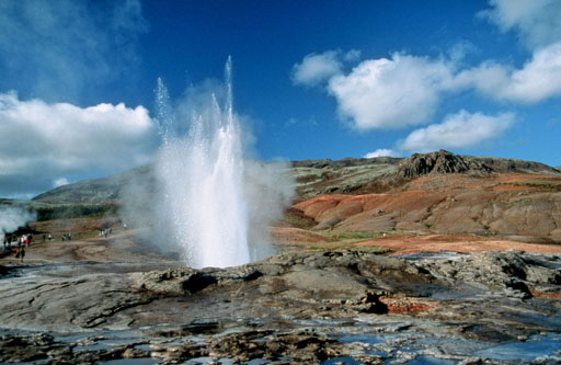
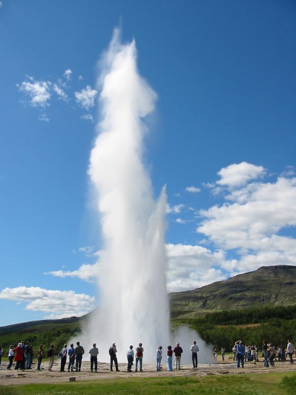
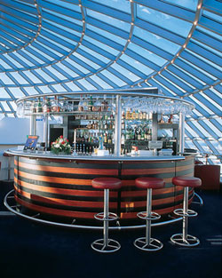
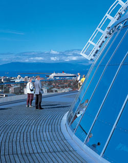
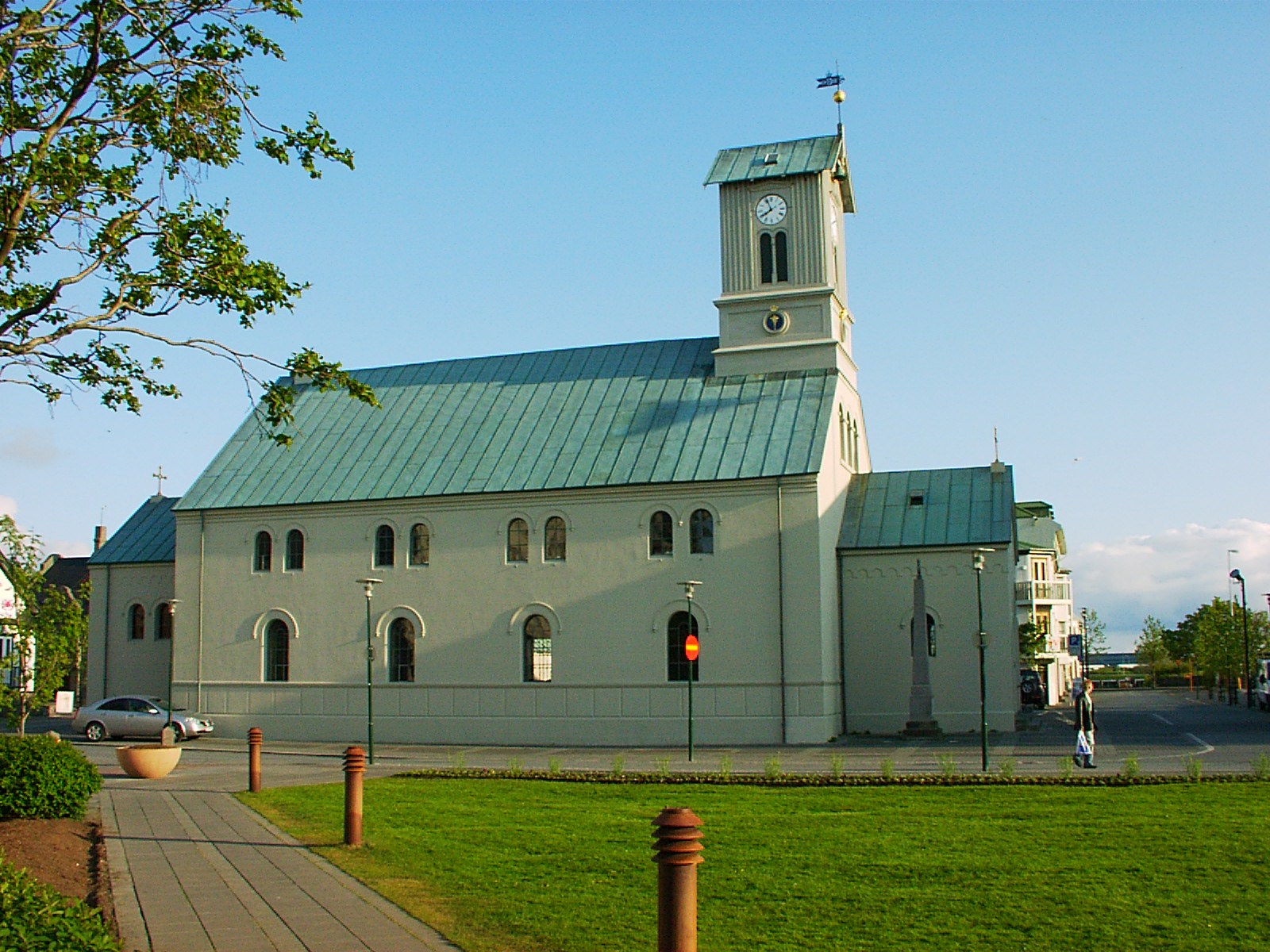
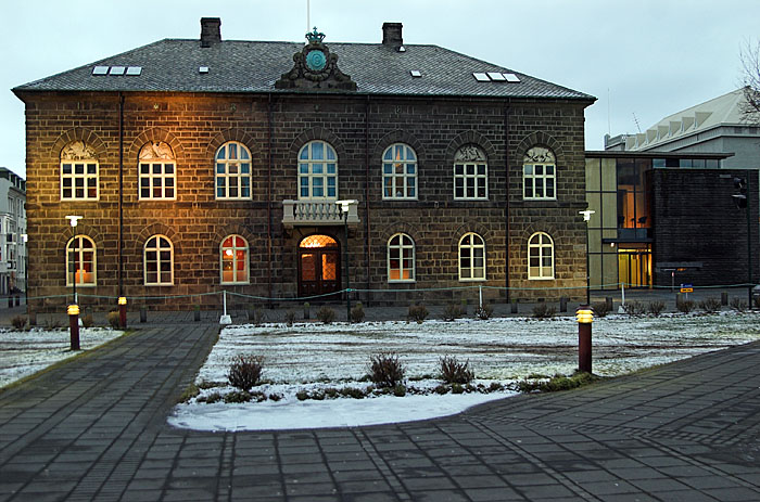
| | | | So that’s what this geothermal field is all about. Let’s start with the smaller items, the hot pools and such. On entering the field, everyone notices the prominently located Litli-Geysir (Photo by Wellington Grey) (Click to enlarge). Like the others, it has boiling water in the center, like the calderas in Furnas on Sâo Miguel in the Azores. On others hot springs that were calmer, it was a matter of looking into clear water on a blue pool-like seashell; sometimes looking into the water-filled shaft was like looking down a throat. | | | | The most famous geyser in the Haukadal field is of course Geysir itself, but nowadays, it’s showing some age and is less active. I read that its eruptions can hurl boiling water up to 70 m (230 ft) into the air, but eruptions are now infrequent, maybe only 4-5 times a day, and in the past, have stopped altogether for years at a time. Needless to say, I didn’t see it erupt, nor do many people. But this is Geysir’s hot spring (Photo by Roman Z); here Geysir starts to erupt (Photo by Dieter Schweizer); and here is Geysir in full eruption (Photo by Andreas Tille)--compare the size of the nearby cars. This YouTube video shows Geysir in action (Video by João Leitão). The eruption comes quickly at 0:30. Note the unmistakable up-and-down “breathing action” of the water before it happens, and also note the water draining back into the caldera afterward. | | | | If Geysir is the “old man” taking life easy in Haukadal--all right, I’ll say it: if this geyser is the local geezer--then Strokkur, just 50 meters/yards south is the vigorous young man showing off his muscles. (There is also a sexual metaphor hiding here somewhere, but I won’t go there.) Strokkur, which means “churn”, presumably for its frequent “churning” action, was first mentioned in 1789, when an earthquake unblocked its shaft. It is much more dependable and erupts much more frequently every 5-10 minutes, at heights variously described as 15-20 m (49-66 ft), or 30 m (98 ft), sometimes up to 40 m (131 ft) high. | | | | This is Strokkur’s hot spring between eruptions (Photo by Chris 73). Click and you can get a very close look. I noted down at the time what you can see quite clearly here, that the inner pool is about one meter/yard across, the outer pool about three, and including the catchment slope that returns water to the pool, eight. Just before erupting, as Strokkur is “about to blow” (Photo by Andreas Tille), the up-and-down “breathing” of the water’s surface is broken by a bubble of rising water and steam, and then Strokkur erupts (Photo by Chris) in all its glory. | | | | Although pressed for time, I saw Strokkur erupt maybe five times while I was there. There were at least as many people waiting around its circumference as this last picture shows, maybe more. I had a few minutes to sit down on a bench to absorb the scene and experience the moment, as I like to do, and away from the shutterbugs, but I also noticed a cluster of maybe 20 people with cameras, all grouped on the west side of Strokkur, perhaps for better light. While the water from most eruptions falls back into the catchment area, the last eruption I was there for was perhaps caught by the wind, and my friend Strokkur, perhaps as ornery as I am, seemed to delight in sending a hefty shower of water over to that group more interested in taking pictures than in experiencing the moment. It resulted in a large laugh for the rest of us on the other three sides. Schadenfreude is best served up cold (lukewarm?). | | | | I have three very short YouTube videos of Strokkur erupting. The first is a smaller, quick eruption from up close (Video by haarts); the second is a double eruption from the circle of spectators (Video by rulosapire); and the third is from a distance (Video by osvaycs). | | | | KERIÐ The Golden Circle is known for adding on the odd stop along the way before Reykjavik, and we stopped at Kerið, a volcanic crater lake (Photo by Progresschrome). Kerið is the result of one of the several volcanoes in the Western Volcanic Zone between Langjökull glacier and the Reykjanes peninsula as the land moved over a volcanic hotspot, but is the one whose remaining caldera is still intact. Kerið’s cone, once it emptied itself of its magma, collapsed in on itself into the empty magma chamber forming the caldera. Typical of the volcanic rock in the area, it’s red rather than black; it’s circa 55 m (180 ft) deep and oval, with the shorter diameter being 170 m (558 ft) and the longer 270 m (886 ft). The lake within the caldera is 7-14 m (23-46 ft) deep, and minerals in the soil give it its deep blue coloring. The water is based on the local water table and not by rainfall. | | | | PERLAN The Golden Circle tour always ends with a zip through Reykjavik. Not that there’s that much in the city to see--Michelin gives it only one star--but a drive-thru struck me as inadequate in 1972, and again this year. We went down the main boulevard and saw the lake, and avoided the charming little streets that a bus can’t get to. This is why I was so glad I was wiser this time and allowed for my own day in Reykjavik later on. | | | | But the bus tour did make a stop at the south edge of town that was very welcome, and which would have been out of the way when strolling in town later. I’ll give it a negative introduction: we stopped at five hot-water tanks on a hill. Doesn’t sound like much? Well, it is typically Icelandic, since these hot-water tanks hold thermal water for the heating of buildings, so that alone is very unique. But while the tanks are still very much in service as they have been for decades, in 1991 they were converted into a landmark building called Perlan (Photo by Clem), which means “The Pearl”, a reference to the glass dome with a revolving restaurant in on the 5th floor, below which is an observation deck on the 4th. Pretty good for hot-water tanks, don’t you think? The entire interior is a large five-story atrium under the dome; this picture, which I presume is upstairs in the restaurant, shows the Perlan bar (Photo by Hotelgreg11), which I include to give an idea of the interior. The outdoor viewing deck (Photo by Hotelgreg11) gives a 360° view over the city, south to Hafnarfjördur, where we’d be headed, southwest over the nearby older airport, now for domestic use only, and its Loftleiðir Hotel where we stayed in 1972, north to the nearby mountains. | | | | But most interesting is the view to the northwest, over the center of Reykjavik (Photo by Srikanth Jandhyala). The most obvious standout is the Hallgrimskirkja, that church at the top of its own hill (more below), but, in addition to the nearby northern mountains at the right, note the mountains in the distance, far in the northwest. Rather incredibly, this is the only occasionally available view completely across the Faxaflói bay to the Snæfellsnes peninsula, a full 120 km (75 mi) away (Map by Maximilian Dörrbecker [Chumwa]). The peninsula is named after the mountain at its far western end, the Snæfell (Snowy Fell), which, because there are two other mountains with that name, is usually referred to by the name of its glacier as the Snæfellsjökull (Photo by Twist42), centerpiece of the Snæfellsjökull National Park, this closer view being from the bay. The day I saw the Snæfellsjökull from Perlan, the sun was illuminating the glacier like a jewel that seemed to be hovering on the horizon over the water, a sight I won’t soon forget. However, while I saw it in mid-June, Wikipedia reports that in August this year, the summit was ice-free for the first time in recorded history. | | | | Snæfellsnes is known for two other reasons: Erik the Red set sail for his exile in Greenland from near it, and Jules Verne, in his 1864 novel A Journey to the Center of the Earth has his protagonists find the entrance to a passage leading to the center of the earth on Snæfellsjökull. | | | | We returned from Perlan to the Deutschland, and sailed that evening, 15 June, for our twelve days in Greenland. We returned to Hafnafjördur on 28 June, which is described below. THE TWELVE DAYS IN GREENLAND WILL BE DISCUSSED IN A SEPARATE POSTING LATER AS A SIDE TRIP FROM ICELAND, OUT OF HAFNARFJÖRDUR. | | | | Second 2012 Day Visit, 28 June The sea voyage of about three weeks out of Travemünde was over on the return to Hafnafjördur, and most passengers would be flying back home from Keflavik. I, however, was pleased with myself for having planned just one more day in Iceland, to see Reykjavik, and it worked out even better than expected. Returning from Greenland, I’d spoken to the Concierge at the Reception Desk about getting into town, since that was the only item in all the six weeks I hadn’t been able to take care of in advance, and he said he’d arrange for a taxi for me, and, with me lacking Icelandic krónur (crowns), for me to pay in dollars. Then, in the last newsletter that evening, it said there would be a shuttle bus into town every half hour from 9 to 5, at which time I told the concierge to forget the taxi. I still don’t understand why they had a shuttle bus, since most of the previous passengers were flying home, new ones would arrive in the afternoon, and very few were doing two trips back-to-back and therefore staying on board in Reykjavik, possibly wanting to go into town, but maybe that’s the answer. Nevertheless, it was to my benefit. | | | | After the three weeks earlier on my own from the Azores through Travemünde, I didn’t realize until that last morning how regimented I felt on the ship--meals at this time, trips at that. There was a strict disembarcation setup starting early for different buses to the airport to catch different flights, and it was a relief not to have to pay any attention to it. I had my last leisurely breakfast in the Lido, and left the cabin shortly before the first shuttle bus into town at 9:00, already totally on my own schedule. I went down the gangway with a group headed for Düsseldorf, and on the ground was a group of ship officials in a reverse receiving line (good-bye line?). The hostess at the end, along with her goodbyes said something to me about Düsseldorf, and I told her, to her surprise, that I was going into town instead, so instead of turning right with the crowd, she pointed me left to the shuttle bus. As much as I’d enjoyed the voyage, I distinctly remember the feeling of liberation I felt as I rolled my wheeled bag across the parking lot to “my” bus. I turned out to be the only passenger on that first run of the day. Before we left, I was glad that the concierge was nice enough to stop by and reach in through the door to shake hands to say goodbye, after which the driver and I departed on my freedom ride through the flower-boxed main street of Hafnafjördur to Reykjavik. | | | | Reykjavik While I will stick with everyone else to the standard, international pronunciation as REY.kya.vik, I understand that KJ is TS, so it’s locally REY.tsa.vik. I had learned what the name meant, and why it means what it does, long before I left on the trip. That’s the reason why I felt familiar, back in the Azores, on São Miguel, in Furnas, at the lagoon, the Lagoa de Furnas (2012/7), seeing what looked like steam or smoke rising from the north shore of the lake as I’d driven up the east side. When I got there, it was just a bluff about a meter/yard high along the shore that was emitting steam from a fumarole, but from across the lake it looked like the steam was coming from the lake. That’s apparently how Reykjavik got its name. The word reyk means “smoke” (cf German Rauch, Swedish rök). Put it in the plural, then the genitive (possessive) case, and you get reykja “of smokes”. Add our old friend for “bay/cove”, vik, and you’ve got “Bay of Smokes”. Steam from hot springs was apparently the basis for the name. But that translation with the plural is awkward, and might better be rendered less literally in the singular as Bay of Smoke, or Smoke Bay. There is a possibility that the same word was used at one time to mean both “smoke” and “steam”, since the two look alike, so it might not exactly be an error in calling it smoke, but calling it steam is more logical. Also, since 80% of the heating of buildings is done with thermal water, which is extremely pollution-free, there is irony in using the translation as “smoke”. I’ll go with “Steam Bay”. | | | | Reykjavik, population 120,000, is the northernmost capital of an independent nation at 64°08’ N. But you have to word that carefully, because Greenland is close to independence, but is still associated with Denmark, so Greenland’s capital, Nuuk, population only 15,500, is the northernmost capital of a constituent state--and also the northernmost capital of any kind--at 64°10’ N, but look how close those latitudes are. The northernmost non-capital city of over 1,000 people is the capital of Spitsbergen, Longyearbyen, population 2,040, at 78°13’ N. | | | | Reykjavik Visit It took the driver and me about 25 very leisurely minutes to reach the center of town--I was finally in a leisurely mood, anyway--and apparently the appointed drop-off was at the brand-new Harpa Concert Hall and Conference Center (Photo by Ivan Sabljak) at the harbor. Click to enlarge to see the detail of the unusual, irregularly-shaped, dark glass panels, the reverse side of which is visible on this interior view from the lobby (Photo by Claus Ableiter). The Harpa is the first purpose-built concert hall in Reykjavik and houses the Iceland Symphony Orchestra and the Icelandic Opera. The opening concert was in May, 2011. | | | | I’ve found I’ve been able to lead the reader rather accurately through the walks taken at stops on this trip to the most interesting and scenic locations of a city, including most recently Stavanger, Lerwick, and Tórshavn. Now, I’m most pleased in having found online an outstanding interactive map of central Reykjavik by Borgarmynd, a “collection of architects, graphic designers and programmers based in Reykjavik”. They state quite modestly (!!!) “We tend to be awesome!”, and, based on this map, I tend to agree. Rather than link directly to their site, I’ll suggest the reader open a separate window, go to reykjavikcentermap.com on his/her own, and follow our movements in the current window, flipping back and forth. | | | | The map will open on an area near the harbor, but without street names for the moment. Note the curved road to the left. To orient yourself, click the minus sign at the upper right once. That curved road is now in front of the Harpa Concert Hall at the harbor’s edge, and leads to the main boulevard, which goes past the lake, Tjörnin. This is the zip-through-town route the bus took on its way to Perlan that first day. Note that the map is turned with north to the upper left, so that that main boulevard is a north-south road. Most of the interesting historic area is to its left (west) between Harpa and Tjörnin. To the right (east) of the boulevard, a long, angled road goes up the hill to the church, Hallgrimskirkja, right center. You have now seen the very walkable center of Reykjavik. | | | | Double-click on the curved road in front of Harpa and drag the map so you can walk with me down the main boulevard for two blocks. Double-click on this intersection and street names will appear. As elsewhere in Scandinavia, gata is “avenue” (related to German Gasse). Obviously, stræti is “street”. Also vegur is “way” (German Weg). | | | | We now see that the boulevard is Lækjargata “Brook Avenue”, since there was once a stream there. The crossroad to one side is Bankastræti “Bank Street”, but to the other is Austurstræti “East Street”. Do as I did and turn right onto Austurstræti, a pleasant shopping street, for one block, then turn left on Posthússtræti, literally Post House Street, but better as Post Office Street, and you’ll be on the main square, and we’re in our “home” area. But for now, cut through those lilac bushes diagonally, and go one block along Kirkjustræti (“Church Street”) to Aðalstræti, where it starts at Túnstræti. And you’ve moved back a millennium. | | | | Aðalstræti Aðalstæti translates as Main Street, which is already indicative of age, since it obviously no longer is the main street of Reykjavik. Today it runs only about three blocks up from the intersection we’re “standing at” at Túnstræti (“Field Street”--it already sounds rural) to Hafnarstræti (“Harbor Street”), which evidently once was the edge of the harbor before likely landfill extensions. Because we are now in the historic center, that Austurstræti meant East Street now makes sense, since it leads to the east from the historic center. | | | | Aðalstræti is the oldest street in Reykjavik, which also makes it the oldest street in Iceland. Not only that, it goes back to Viking times, and it’s considered that first settler Ingólfur Arnarson, who arrived in 874 (2012/20), and who was the one who named this fishing village Reykjavik, had his homestead near to where “we’re standing” at the southern end of Aðalstræti. Aðalstræti is most likely the path he used to walk down to the sea. | | | | Over the centuries, inasmuch as it really was the main street, it was lined with the homes of influential people, public buildings, and the town’s main well, appropriately named Ingólfsbrunnur (“Ingólfur’s well”), outside the present No 9. One of the oldest buildings in Reykjavik, built around 1762, is No 10 Aðalstræti (Photo by TommyBee), which is the time of Governor Skúli Magnússon. He was the one who started industry in Reykjavik, and in Aðalstræti there were wool-factories and stores on both sides of the street. This coming of industry changed Reykjavik and lead to it becoming a town in 1786. | | | | Click once more to come in closer. The oldest house is the brown-roofed one on the west side of the street, with a symbol over it. Now come back one block south to “our” intersection. The three-part building with black roofs you see there is the Hotel Reykjavik Centrum at Aðalstræti 16, which I’m so glad to have discovered online. The oldest part is the center wing, a recycled building from 1764, which today includes the lobby. It was rebuilt many times for many uses, including once being a wool factory and once being a government residence--uses that fit in so well with the street--and in 2005 became part of the hotel. The wings on either side are replicas of buildings that used to stand on the street, so the whole complex has both a modern and historic air to it. | | | | When a street is so historic, you can’t help finding some antiquities when digging. Under the hotel, archaeologists found the remains of a 10C Viking longhouse with artifacts, which is now a museum in the hotel basement called the Settlement Exhibition! You can peer down through glass panels on the sidewalk outside the hotel and see part of the longhouse below. | | | | I checked in to the hotel and was happy to see my room was available, given it was only about 10 AM. The clerk was very helpful, and arranged my airport bus for the following morning on the spot. I asked about internet service, and he apologetically gave me an hourly price in krónur of about $4 and full-day of $12. I told him I was glad about that low full-day price, since the Deutschland had been charging me €20 an HOUR, to which his jaw dropped. | | | | My very comfortable room was on the side of the building facing Túngata, and this is where the feeling of freedom expressed itself. I felt the urge to get going to see the town, since it was my only day, and with good weather, but I yielded, and decided to lower the pressure and relax. I unpacked, went online and did some business, and only about an hour later strolled out to see the town. Freedom is great. | | | | Austurvöllur On the map, stroll with me one block back to the main square, Austurvöllur (“East Field”). It’s a popular gathering place, due to the prevalence of cafés (Photo by Jóhann Heiðar Árnason). This YouTube video taken the same time last year shows Asturvöllur abloom with lilacs, just as I saw it this year (Video by hafmundur). | | | | It’s also a usual place for public protests to take place, since the Alþingi is at the south side of the square. Austurvöllur in size is just a shadow of itself, since it was much larger in the past. In the early 18C, it started at Aðalstræti and ended at the brook at Lækjargata, went up to the harbor and down to the lake, Tjörnin. | | | | As you can clearly see on the map, on the south side of the square is the Lutheran cathedral, the Domkirkja (Photo by Jutta234), after which that street in front of it is named. It’s the oldest church in town. Look down the street at how close the lake is, just a block away. The map shows that opposite both the church and park is Parliament House, the Alþingishúsið (Photo by Cicero85 in a winter view), the home of the Alþingi after it was reestablished in 1845 (after being abolished in 1800--see above), although the actual building dates from 1881. | | | | Look again at the map to see the garden behind the Alþingi that I walked through next, followed by taking a look at the archeological dig on the same block, which is actually diagonally across from the hotel. Explanatory panels there show that this dig is the largest in Iceland, and has yielded artifacts from the 9C to the 20C. | | | | Tjörnin Now look across the street at the very modern City Hall, which is also an art gallery. Note how it’s built partially in the water of the lake called Tjörnin “The Pond”. It’s far from the biggest lake in Iceland, but is so scenic and well-located right in town that most visitors stop to see it. There’s also a causeway to a pavilion area where people feed the swans and ducks. Now look at this 180° view of Tjörnin (Photo by Jóhann Heiðar Árnason). Click to enlarge to see the detail in this cold-weather view. Note the causeway I took from City Hall to the waterfowl feeding area, and in the center, note the iconic tower of Hallgrimskirkja, which is our next and final stop. This YouTube video shows the Tjörnin in summer (Video by ReykjavikVideos). | | | | Hallgrimskirkja On the map, we’re back at Lækjargata, so walk north for just two blocks, and turn right into Bankastræti. In a couple of blocks it forks into two streets. This whole area is busy with shops and restaurants, some with sidewalk cafés. Take the right fork uphill (puff, puff) on Skólavörðurstigur. Don’t wince at the length of the name, but take it apart into skóla+vörður+stigur and you have School Guard Path. This is the view uphill (Photo by Molde20). At its top you come to a statue and behind it, the tower of the church. We’ve made it. | | | | Hallgrímur Pétursson was a 17C Icelandic poet and cleric, and the church is named after him. It was built between 1945 and 1986. The landmark tower, which is what one usually notices first, was completed long before the church itself, which is really only visible in a side view (Photo by Girdi). | | | | On arriving up on the hill, the Hallgrimskirkja tower overwhelms (Photo by Someone35). It’s very white and minimalist, as is the entire church, but with Gothic overtones, such as the pointed windows. The unusual tower, 73 m (240 ft) high, has been symbolically described two ways. One is that it’s meant to resemble the basalt lava flows of Iceland’s landscape, and the other, which I prefer by far, is that it’s meant to represent a huge white geyser. Note two things on the picture, the windows at the top (three on each of four sides) and the pink marble pedestal in the foreground. The pedestal, as seen in this winter view (Photo by Andreas Tille) is of the statue of Leifur Eiriksson / Leif Ericson that one sees first on arrival at the top of the hill. It’s a memorial by Alexander Stirling Calder and was a US gift to Iceland to commemorate the Alþingi millennium in 1930 of its founding at Þingvellir in 930, so counterintuitively, the statue predates the church. | | | | Taking the elevator up the tower, I got extensive views over Reykjavik, such as this one over Skólavörðurstigur, the street I’d come up and would take back (Photo by Yelkrokoyade). Note both in that picture and in this next one the typically colorful buildings and rooftops (Photo by Bjørn Giesenbauer), something that was even more typical, I would find, in Greenland. | | | | Reykjanes It was an early up the next morning, my last of the six-week trip, to take the shuttle bus from local hotels to the local bus terminal to connect to the airport bus to Keflavik International Airport, some 50 minutes beyond. It went right past the harbor in Hafnafjördur onto the Reykjanes peninsula (Map by Biekko), which is marked by active subterranean volcanism and large lava fields on the surface (Photo by Vincent van Zeijst), with numerous hot springs and sulphur springs, allowing for little vegetation. The steam on the left of the picture comes from the geothermal power station at the appropriately named Svartsengi (“Black Meadow”), which produces large quantities of electrical energy and hot water, at 90°C (194°F). At the far end, the town of Keflavik (“Driftwood Bay”) itself was merged in 1995 with smaller adjoining towns into the municipality of Reykjanesbær (bær = town), but the airport is still called Keflavik International (Photo by Simisa). Note the barren landscape around the airport, whose one terminal is named for Leifur Eiriksson. I was well aware of the historic parallel of that name to me flying (on a plane named Eyjafjallajökull) along his sea route near Greenland and Newfoundland to North America. | | | | On arrival back in Boston, I was back where I’d started the Atlantic Isles trip out to the Azores. I had to smile at the one little thing that went wrong when one plans carefully. I’d had one ride left over on my Charlie Card, which I’d used six weeks earlier to get to the airport, but went out of my way to buy one more ride before I left for when I got back. But it was only when getting on the Silver Line bus that I was told that trips FROM the airport are free. Oh, well, a minor loss. At South Station, since I’d made such good time, I was able to take an earlier train than I’d booked, business class on points, back to Penn Station in New York. | | | |
| |
|
|
|

