|
Reflections 2012
Series 22
December 4
Acqua Alta: A Chronicle of Hurricane Sandy in Greater New York City
| | I had interrupted writing up my notes on Greenland to do some necessary and extensive across-the-board updates on the website, adding pictures and fixing dead links. But with the arrival of Sandy, I interrupted that second project as well and, at the urging of several friends, started collecting notes on the hurricane for a Sandy posting, so as I write this, I have two website projects on hold. | | | | I did get as far as repairing 2002/2, my last visit to Venice, so you can check out the photographic improvements there if you like, but the point is, I was in Venice that year in the summer, and it's in the winter, mostly November and December, that one hears about the infamous acqua alta the "high water" that periodically inundates Venice, as well as nearby cities on the mainland. Regular high tides are supplemented by seasonal high winds that can reach hurricane force, such as the scirocco from the Sahara, and the bora locally, which either push a storm surge up the Adriatic and into Venice's lagoon, or conversely, prevent floodwaters from leaving, resulting in scenes such as this in Piazza San Marco, where, if the flooding is significant enough, the city installs temporary wooden walkways (Photo by Giovanni Mello), such as these for tourists waiting to enter the Basilica di San Marco. Lesser-known neighborhoods are also affected, such as this local area (Photo by Abbag) on the other side of the Grand Canal, where the local canal, on the right, has flooded the sidewalk on the left and its café. | | | | It's estimated that an acqua alta of 90 cm (35 in or almost 3 ft) would leave Venice virtually unaffected; 140 cm (55 in, or over 4 ½ ft) would cover more than half of Venice; anything over 200 cm (79 in or over 6 ½ ft) would cover all of Venice. During Hurricane Sandy, the storm surge at Battery Park at the lower tip of Manhattan was 13.88 ft (4.23 m). Compare that to Venice. Sandy's surge at Battery Park surpassed the previous record surge in 1821 (see below) of 13 ft (4 m), that earlier surge having come within one hour, and at low tide to boot! The maximum surge during Sandy recorded elsewhere in the region was 17 ft (5.2 m). Who ever thought New York could have an acqua alta that would surpass even Venice's worst-case scenario? | | | | It seems to me that the news media have documented the story very well, both nationally and internationally, but it would also be fitting to supplement those reports on this website, as I also did for Nine Eleven, and would thus be from one who rode out both events. One dictionary definition of "chronicle" is "a detailed narrative record or report", but this chronicle would be different in that it would be an update of places visited in the past and discussed earlier on the website. | | | | However, on a personal basis, I actually had little to ride out. I'll mention for the time being that, given all the chaos in the City and the region, I was lucky enough to be personally unaffected by the storm. Despite being in the center of the maelstrom, I didn't evacuate, didn't lose power, phone, or internet, was not flooded, and had a supply of food on hand. On that basis, I then had time to sift carefully through daily copies of the New York Times, and watch TV reportage of events as they were occurring, primarily on the news station NY1, including speeches by New York City Mayor Michael Bloomberg and New York State Governor Andrew Cuomo. This is the exact opposite of the period right after Nine Eleven, when we were without power and were really quite out of it as to what was going on, even though we were just four blocks from Ground Zero, not learning details until days later when we were in a hotel. This time, from the Times and TV, I made several pages of notes, which I've supplement by online research and a large number of illustrations. | | | | | | I used the word "maelstrom", which I felt to be appropriate, but which I decided to look up. It's indeed particularly appropriate, given that New York was once New Amsterdam, that "maelstrom" is a Dutch word in antique spelling; its modern spelling would be "maalstroom". "Malen" is "to grind" (related to [corn]meal) and "stroom" is "stream", and those two words are related. Therefore a maelstrom is literally a "grinding stream", which is sometimes narrowly used to refer to a whirlpool, but more generally describes any violent, turbulent, confusing, frightening situation involving a lot of activity and strong emotions. I think "maelstrom" fits well to what happened to the Northeastern United States and Eastern Canada. |
| | | | Previous Experience While my daily routine wasn't interrupted at all, it doesn't mean I haven't paid my dues in the past. In a word, during Nine Eleven, we sat for three days and two nights in this very apartment without power, phone, internet, or flushable toilets, and only by chance had plenty of food on hand. Fortunately, cold weather wasn't a factor, since it was autumn, nor was flooding a factor, but toxic dust and ash were, and after we evacuated, an industrial-strength cleaning company came in and our homeowners insurance, at no cost to us, covered several thousand dollars worth of cleaning for the entire apartment during our absence in Florida. When we finally did evacuate to go to a hotel, building staff carried Beverly, seated in her wheelchair, down six flights of stairs, and a Parks vehicle brought us to an outdoor evacuation center on Fourteenth Street and the Hudson River, where there was a catered buffet of foil serving trays of hot food. As evacuation vehicles dropped all of us off, people on the sidewalks applauded. Finally another vehicle brought us up to a midtown hotel. For the balance of the story and further details, refer to our Nine Eleven experiences in website articles running from 2001/11 to 2002/1. | | | | Beyond the wind damage, it was coastal flooding that typified Sandy, so I'll reflect on three experiences I've had with flooding, fortunately all minor, and nothing like what people along local shorelines experienced. During my Junior High School years, we lived in a low-level apartment at the bottom of a hill on Arlington Avenue in Brooklyn. Several times during each summer, when rains were heavy enough, about an inch or so of rainwater from the hill would regularly flood our living room, so my family was wary every time it rained. Then when Beverly and I built our house in Purchase NY, a branch of Blind Brook was on the western side of our property, and, again, heavy rains a number of times during the year would raise the brook well up onto our lawn, and approached our terrace. Fortunately, our builder had recommended adding landfill to build up the height of both the terrace and house, and, while the water often reached the terrace before retreating back into the brook, we were never flooded. Still, we were wary every time it rained. Watching water approach, but not flood, was similar to my Sandy experience. | | | | Finally, I did have an experience of being inside a building with water up to my knees, and seeing a car ruined by flooding, but quite fortunately, it was neither my building nor my car. We had discovered in Florida a wonderful French restaurant called Île de France in Hudson FL about a half-hour's drive west of us on the coast of the Gulf of Mexico. We'd gone with friends many times. The last time we went, we went with friends Ron and Roseanne, and unfortunately for Ron, he said he'd drive the four of us. The restaurant backed up on an inlet—there may have even been a dock—and the parking lot was on the side. In the front, I don't thing there was more than a single step up to enter the low-lying building. That evening it started to rain, and a storm surge—just like with Sandy—started to build up, but relatively slowly. The inlet flooded in the back, and I left the table to look out the front of the restaurant, where water was running down the road. It wasn't wise to leave, so we stayed and finished dinner. I kept on checking, though, and the water came up to the front door, then gradually entered the premises. We took off shoes and socks and had water up to our knees. Waiting it out, we sat on chairs with our feet on other chairs, and water almost up to the seat level. Finally, it started to subside, so we could leave, but Ron's car was totally flooded out, and his insurance later covered his buying a new one. An employee drove us home. Thus, it wasn't my building and wasn't my car, and the experience is certainly not anywhere near to what happened to so many people during Sandy, but I do know the gut feeling of not only watching floodwaters approach gradually, but also enter the room you're in. I can only picture how it must be when they approach rapidly. | | | | Hurricane Sandy I don't follow weather reports at all, and when friend Dwight in Florida sent out notices of Sandy there, I paid little attention. But the Friday before Sandy, which came on a Monday, friend Paul in New Hampshire mentioned it, since they were coming down to Brooklyn to stay a few days in their rental apartment there in Carroll Gardens, in preparation for sailing once again on the Queen Mary 2 to the UK, leaving, as usual from the Brooklyn Terminal in Red Hook. They were glad the ship was sailing on Sunday, just beating Sandy, due the next day. | | | | But if I hadn't been advised by friends about Sandy, I would have heard about it anyway Friday as New York City began preparations. As of 7 PM Saturday, the entire subway system was closed, something that only happened once before, when Hurricane Irene struck just fourteen months earlier. For Irene, I had, by chance, left by train to Vermont the day before a mandatory evacuation had been declared for low-lying neighborhoods including mine ("Zone A"), so while Irene was not as severe in NYC as it could have been, I did experience the river flooding of Irene while I was in Canada and Vermont (2011/23). | | | | Hurricane Sandy turned out to be the largest Atlantic hurricane and super storm in diameter on record, since it was an unusual hybrid of Hurricane Sandy proper combining with a nor'easter. A nor'easter, named for the direction the wind comes from, is a storm with hurricane-like characteristics that is typical of the northeastern US and Eastern Canada, and that usually occurs between October and April. As Sandy came up the east coast, it joined forces with the nor'easter. | | | | This is the track map of Hurricane Sandy (Map by Cyclonebiskit), from where it came in the Caribbean to where it crossed into the US at New Jersey, a short distance from Atlantic City. Each symbol shows the location in six-hour intervals. The earliest symbols are a deeper blue, indicating a tropical depression, defined as having maximum sustained wind speeds of 0-62 km/h (0-39 mph). It then progressed to the lighter blue symbols indicating a tropical storm of 63-117 km/h (39-73 mph). But most of the symbols are beige, indicating a Category 1 Hurricane of 119-153 km/h (74-95 mph). Yet when it hit land, it slowed down, so it was technically a tropical storm again, but that hasn't stopped anyone from referring to it as Hurricane Sandy. That is, except some insurance companies, which refused coverage to owners with a hurricane policy, since Sandy "wasn't a hurricane!" | | | | This is a satellite image of Sandy, showing a very well-defined eye. It was taken at 17:50 Universal Time (UTC) on Sunday, 28 October 2012 (13:50 EDT or 1:50 PM), the day before it struck. Note the east coast of the US, and click on the upper center of the image to enlarge the outline map in the NY-NJ area. | | | | In the United States, Sandy affected at least 24 states, from Florida to New England, and then eastern Canada afterward. When it did come ashore near Atlantic City, it was at about 20:00 (8 PM) on Monday, 29 October, 2012. It struck me immediately, although I didn't hear anyone else mention the fact, that in 1929, 29 October was the day of the stock market crash, and was called Black Tuesday. Was Sandy a Black Monday this year? | | | | Three elements appear in a hurricane, and I'll discuss them in reverse order of seriousness AS THEY APPEARED IN SANDY: rain, wind, flood. This is the order of importance in which they were predicted on TV for Sandy and this is the order in which they did result. | | | | In some storms, it's the rain that does the most damage. When Hurricane Irene struck, a mere fourteen months earlier, while it hit New York City, it was much worse to the north, with ran causing freshwater flooding of creeks and streams, which I saw the results of in Canada and Vermont. But with Sandy, just as predicted, there was little freshwater flooding in the New York City area. | | | | One thinks immediately of wind damage. In 1992, Hurricane Andrew struck just south of Miami. In addition to coastal flooding, it was known for horrendous winds that took roofs off houses, and carried houses away. I remember driving from Tampa to Miami some time afterward to visit relatives and see how their houses had been affected, and I particularly remember arriving in the western suburbs seeing block after block of destroyed houses similar to those in this neighborhood. | | | | But with Sandy, wind damage directly to houses had nothing like that kind of severity. There was very little "I'll huff and I'll puff and I'll blow your house down" syndrome. Wind damage caused by Sandy was mainly its affect on trees, either falling on houses and cars, sometimes fatally, such as on this pickup truck in Montgomery NY (Photo by Daniel Case), on these power and telephone cables, here in Walden NY (Photo by Daniel Case), causing power failures and a break in communication. These two communities are in the Hudson Valley, but outages occurred across the region. Great numbers of trees fell on rail lines (Photo by MTA Photos), such as here near the Cold Spring Station in the Hudson Valley, causing rail transportation to come to a standstill. | | | | I remember one instance in Flushing, Queens, near where my nephew and his family live, where a tree fell on a house killing a young man in his bedroom. There was another instance of a tree falling on a house in Westchester and killing two boys watching TV in their living room. The statistics are that NYC lost 8000 street trees and thousands more in parks and woodlands, twice as many as during Irene. An early report was that at least 100 downed trees were blocking rail lines, halting service. Blocked were both railroad lines and subway lines that run in open cuts. | | | | But it was the wind's affect on trees knocking down power cables that an affect on most people, although not in Manhattan. Ever since the 1888 nor'easter known as the Blizzard of '88 caused chaos in New York and the entire Northeast, New York (Manhattan) banned overhead cables such as this bizarre network. But overhead cables are common everywhere else in the region, such as here on Long Beach Island (Photo by Leifern) in New Jersey. (Long Beach Island, discussed below, is a barrier island. This view of Engleside Avenue in Beach Haven looks inland toward the bay, then the mainland. While there are few trees here to damage the overhead cables as they did elsewhere, the storm surge from the ocean would have come from behind the viewer and covered this entire area.) | | | | So then it's the third factor, the storm surge, that was the greatest villain with Sandy causing the most devastation. Of course, the storm surge is also caused by wind, but ocean flooding is significant enough to be put in a category by itself. Unlike the freshwater flooding of creeks, a storm surge involves even more damaging sea water, and resulted in modern New York's first acqua alta. | | | | If you're not sure what a storm surge is, simply pick up a full cup of hot coffee. Blow across the surface to cool it. The ripples you've created are a storm surge, rising higher than the normal surface. Blow hard enough, and the surge will overflow the rim of the cup, in other words reach land and flood it. If the cup is not quite full (low tide) your surge might do less damage, maybe even no damage, to the land. If the coffee is brimming (high tide) when you blow, people had better run for the hills. | | | | A storm surge can come relatively gradually, like the filling of a bathtub, which is what I experienced in that restaurant in Florida. Or it can come suddenly and smash into houses, flattening them, doing the equivalent of Andrew's wind damage. We tend to think of water, because of its liquid nature, in terms of raindrops on your face, but recall the last time you carried a bucket of water and its weight causing the bucket handle to bite into your fingers, or recall the last time you stood in the surf at a beach and were knocked over by the force of a wave. Now picture a larger version of that wave hitting a house. | | | | But where it doesn't smash, and drown people in single-floor houses, where there's no upstairs to flee to, it ruins. I saw the results of Katrina's flooding in New Orleans on that bus tour (2007/1) and the following year when I drove myself through some neighborhoods (2008/2). Picture the ground floors of the above Beach Haven houses under water approaching ceiling height, and water in the street. | | | | Previous Hurricanes The Blizzard of '88 goes down as the most memorable nor'easter in New York history, but it wasn't a hurricane. Actually, most such storms have been close calls rather than direct hits. There have been five direct hurricane hits on NYC: (1) one determined by scientific research that hit sometime between 1278 and 1438; (2) one in 1821 (below); (3) one in 1893; (4) Irene in 2011; (5) Sandy in 2012. | | | | In 1821, a hurricane struck what is now New York City. It struck Jamaica Bay, in Queens near what is now JFK airport, which also means it must have crossed the Rockaways to get there, but at that date, the Rockaways would have been unpopulated. The storm surge added 13 feet (4 m) to tide levels in just one hour, causing the Hudson and East Rivers to meet in southern Manhattan up to Canal Street. At that time, Canal Street would have been near the northern city limits, so that would mean that all of populated Manhattan at the time would have been inundated. It's difficult to imagine. | | | | Other major hurricanes that came close to NYC in more recent times without direct hits are: (1) the Hurricane of 1938, which Long Island and New England remember particularly well, since they were severely hit. But it had a lesser affect on NYC, although there were 10 deaths, no power in Upper Manhattan and the Bronx, and 100 large trees were felled in Central Park; (2) Hurricane Carol in 1954, a Category 3 storm, which was similar in intensity to the 1938 storm and had a similar path over Long Island and New England. NYC again was less affected; (3) Hurricane Donna in 1960, which also had Category 3 intensity. It had an 11-foot (3.4-m) storm surge, which is 2 feet (0.6 m) less than Sandy's, though. Among other damage, Donna disrupted some subway and rail lines. The Times printed a picture of West Street waist-high in water. West Street (below) is two blocks east of me and was flooded again by Sandy. | | | | Sandy's Affect on the NY-NJ Region It seems rather odd that we were talking about the geography of New York harbor only recently (2010/27), and also that we've had entries on visiting most, if not all, of the places that Sandy damaged. In that posting, we showed the map of the New York Bight, including the Hudson canyon (depth exaggerated). Note how an storm surge such as Sandy's would rush up the arrow-like formation pointing at New York Harbor. Look at the barrier islands and barrier peninsulas (some would-be barrier islands are attached at one end to the mainland and so can be called barrier peninsulas) along the Jersey Shore, where Sandy hit land near Atlantic City, about a third of the distance from Cape May in the south and Sandy Hook in the north. Look at the barrier islands and peninsulas along Long Island's South Shore. All these islands have bays behind them, then the mainland, and the storm surge reached well into the mainland. Look how the "arrowhead" of the Bight points at Staten Island at the harbor entrance. | | | | This is the satellite image of the area (click to enlarge, as needed). Sandy Hook at the left and the Rockaway peninsula across from it define the entrance, which points at Staten Island. Inspect closely all the barrier islands (sandy beaches are visible—there's a pun in there somewhere), the bays behind them, and the nearby mainland, all of which the surge reached. Note the Hudson River, which is largely a tidal estuary for a great distance upstream. Note how the strait called the East River had to absorb the surge from two directions, up from the harbor, and down from Long Island Sound. | | | | I feel it necessary to restate that the below summaries, while covering all areas in the region, does not cover all localities within each area, since there is a limit to the information I was able to glean from the Times, TV, and Wikipedia. In addition, I'll state again that the emphasis is on places visited, mostly in the recent past, with corresponding postings on this website. | | | | JERSEY SHORE The Jersey Shore consists of the coastal areas of four New Jersey counties. Up from Cape May County is Atlantic County, including Atlantic City (Photo by Bob Jagendorf), visited in 2011 (2011/4), near which Sandy came ashore (note in the background of this barrier island the bay, then the mainland). While all the casinos apparently fared well, 70-80% of Atlantic City was under water, such as is seen in this view (Photo by US Air Force) out the back of a New Jersey Army National Guard cargo truck conducting relief operations the Monday Sandy struck. Since this was taken during daylight and Sandy struck in the evening, presumably the water got much deeper than this. | | | | Next up the shore is Ocean County, which seems to have the longest segment of the Jersey Shore (see inset). Long Beach Island is in pink, then comes the Barnegat Peninsula, where I've climbed to the top of the Barnegat Lighthouse. Also note that the town of Seaside Heights, with its amusement pier I once visited as a child, is where Highways 35 and 35 meet. We already saw a pre-storm picture of Beach Haven, shown on the map, but this is another area of Long Beach Island post-Sandy (Photo by US Air Force). While all houses are flooded, note the one that was particularly devastated. | | | | In Seaside Heights on the Barnegat Peninsula, this is a view from the boardwalk onto the amusement pier in better days (Photo by Dough4872). This is a side view from the beach (Photo by Jimmypitt1234). Finally, this is an aerial view after Sandy (Photo by US Air Force). Click to enlarge to inspect how thoroughly the pier has been eaten away, and how the Star jet roller coaster now looks like a skeletal sea serpent. 17 blocks of boardwalk are also in splinters, which is typical post-Sandy along the Jersey Shore and Long Island's South Shore, including the Rockaways and Coney Island. | | | | The final county, at the north end, is Monmouth County. That includes Spring Lake, visited on another trip in 2011 (2011/4), where I was happy to stay again at the Normandy Inn (Photo by Dmadeo), a Victorian building in a Victorian neighborhood. I emailed them after Sandy and have not gotten a response. This is North End Beach (Photo by Rmccold), with its boardwalk, dunes, and oceanfront houses. I've bicycled here from the Inn just over a block away up Tuttle Avenue, and I fear the worst. | | | | At the north end of Monmouth County is the barrier peninsula in the form of a sand spit, Sandy Hook (Photo by Batkins), which was flooded, as were other locations discussed on the drive in 2011/5, Ocean Grove, Asbury Park, and Long Branch. This view is over Highlands NJ, and on a clear day, the New York skyline would be visible in the distance. Down below, along the shore in Highlands, is Doris & Ed's, the restaurant I took the catamaran ferry to from the Wall Street dock in 2011/4. It's right on the shore, and their website says "Doris & Ed's remains closed due to storm and water damage". | | | | LONG ISLAND SOUTH SHORE & ROCKAWAYS The other major exposed coastline is the South Shore of Long Island, consisting again, primarily of 121 km (75 mi) of barrier islands and peninsulas, with bays behind them, then the mainland, all of which were flooded, including part of the mainland. On the map can be seen on the left Coney Island, which is now connected to Brooklyn by landfill, and the Rockaway Peninsula in Queens, with Jamaica Bay behind it. Then beyond the city limits can be seen Jones Beach Island, Fire Island, and the very long Westhampton Island. A coastal storm surge also came down Long Island Sound, affecting shorelines around it, including Connecticut, and reaching to City Island in the Bronx, then continuing down the East River to meet the surge coming up the harbor. All of the tidal Hudson River shown also had a surge. Power outages on Long Island reached an incredible 90%, some repaired relatively promptly, some lasting for weeks. These Long Island Rail Road tracks (Photo by MTA Photos) on the Oyster Bay Branch on the North Shore show downed, live electric cables. Click to enlarge to see how they touch the tracks. | | | | The barrier islands and peninsulas were all under evacuation notice, being in the so-called Zone A, the zone most likely to be flooded. Just before Sandy, there were pictures of the ferries leaving Fire Island for the mainland, but then the mainland was evacuated as well. There have been large dunes on the sea front affording protection, but word has it that these were washed away in many communities. A Times picture showed dunes missing that had done their job, but that won't be there next time. I understand the communities I visited were hard hit. I emailed the Belvedere where I stayed, but again got no reply. | | | | Two islands west is Long Beach Island (Photo by Jorfer), which has the same name as the one in New Jersey. The lighter-colored area is the City of Long Beach, and to its west is the village of Atlantic Beach. Click to enlarge to inspect on this pre-Sandy picture the narrowness of the island, and the bay and mainland beyond, all flooded. | | | | The Rockaway Peninsula has been in the news a lot because of all the destruction. Much of it, as well as Jamaica Bay, is part of the Gateway National Recreation Area, including Sandy Hook and parts of Staten Island, all of which were in harm's way. This detail shows the peninsula is attached to Brooklyn by bridge, and a causeway with a road, and trestle with the subway, both cross Jamaica Bay to its center. Where the peninsula is attached to the mainland of LI on its east end (Photo by Jorfer) is Kennedy Airport (runways in background). Numbered streets in the Rockaways start in the East and are prefixed with "Beach". The black line running the length of the peninsula is the east end of the elevated subway line, which starts in the East at Mott Avenue and roughly Beach 22nd Street. The rail trestle crossing the bay can be seen at the left at about Beach 84th Street, at which point the west end of the elevated continues to Beach 116th Street. | | | | On this map of the New York Subway (Map by CountZ, Jake Berman), click to enlarge the lower right showing the trestle leaving the Howard Beach Station, crossing Jamaica Bay with an island stop in Broad Channel, then splitting to Mott Avenue in the East and Beach 116th Street in the West. | | | | ALL of the Rockaways were under water at the worst of Sandy. On the mainland, Howard Beach was under water for at least a dozen blocks inland. Much of the open land area of JFK Airport was under water, and the arrival area of Delta's Terminal 3 was severely flooded, color-coded maps indicating it was in the 6-18 ft (2-6 m) range of depth. The AirTrain rail connector there that brings passengers to and from the airport was under 15 ft (5 m) of water. | | | | Only a year ago, I took a number of rides on subway lines in New York which I either had never been, or hadn't been for a long time (2011/4). I hadn't been on the line to the Rockaways for a long time, so I'm now very familiar with it. When you're well oriented, note this trestle damage with a totally washed-out track support as the line crosses the Bay. Note this boat washed up onto the tracks on the rail causeway. This is what the open-air Broad Channel Station (Photo by Rayv145) on that island looks like in normal times. I saw news pictures of it on TV where debris filled the spaces between the tracks so you had no idea there were tracks there. | | | | When I was in Toronto (2011/29), I told of an outlying subway line that was standard gauge, while most of Toronto is not, and I found it so unusual that, in order to service trains on that line, the cars have to be placed on trucks and driven through the streets to the rail yard. I never expected to read about that happening here, but it did after Sandy, in the Rockaways. It was determined that, while the trestle would take six months to repair, the Rockaways could still have local service, and so, by the weekend after Sandy on Monday, 20 subway cars, each 60 ft (18.3 m) long and weighing 40 US tons (36 metric tons) were loaded on flatbed trucks in Ozone Park, just north of Howard Beach, driven over four nights over Cross Bay Boulevard, the vehicular causeway over Jamaica Bay, to the Beach 116th Street station at the west end. I saw night pictures of cranes hoisting the cars onto the elevated structure. Then, at the Mott Street Station at the eastern end, a shuttle bus service has been instituted to bring subway passengers around Kennedy Airport to get on the remaining line at Howard Beach. At the moment, the Rockaway subway service is free of charge. | | | | On Beach 115th Street, one block from the last stop on the subway, is the house Woody Allen used for his 1987 film Radio Days, set in the early 1940's. It was flooded with 5 ft (almost 2 m) of water, but will survive. | | | | Look again at this area map. West of the end of the line at Beach 116th Street are several communities, including Belle Harbor, which is considered to run from Beach 126th to Beach 142nd Streets, and then, after some parkland, the very isolated community of Breezy Point, whose streets run up to Beach 227th Street. | | | | Belle Harbor, some of whose residents were interviewed on 60 Minutes is populated with many first responders, both firefighters and police. The community lost many individuals in Nine Eleven, and then on 12 November the same years, American Airlines Flight 587 crashed in the center of Belle Harbor, killing all 260 passengers and crew on board, as well as five people on the ground in Belle Harbor. Then once Sandy struck, with water in the Rockaways running head-high in the streets, Belle Harbor was one of the communities that had a major fire, which firefighters could not reach. | | | | More notorious is the fate of Breezy Point. I remember a few years ago trying to visit the community, knowing that it was isolated behind a fence, and I drove along the fence from bay to ocean, just barely being able to see houses on Beach 201st Street behind the wall, but not being allowed to enter via the residents' gate. I know there are gated communities elsewhere, but Breezy Point had in it what seemed to have once been city streets, but which were now private ones. And it's not a wealthy community as one might think, but largely a working class community, which is, ironically, inhabited by many firefighters and police. | | | | I now learn that the community is run by the Breezy Point Cooperative, not exactly a home-owners' association one would expect given the individual houses, but more like a cooperative apartment building is run. Residents pay maintenance, security, and other common costs. The cooperative owns the entire 500-acre (2 km²) community. Residents own their own homes and hold shares in the cooperative. The community's zip code is 99.2% white and has the second-highest concentration in the US of Irish-Americans, at 60.3%. (First is Squantum, in Quincy, Massachusetts, with 65%.) Frank McCourt, author of Angela's Ashes, mentions in his memoir Tis that his mother, Angela McCourt, spent time with him at a house in Breezy Point. | | | | Breezy Point is patrolled by its own private security force that restricts access to owners and their guests. Beyond that, of New York City's only ten remaining volunteer fire departments, three are in Breezy Point. Breezy Point is not unique as being a private enclave, since, at the western end of nearby Coney Island is the 113-year-old private enclave of Sea Gate, which has 850 homes, and whose land once belonged to the Vanderbilt family. Sea Gate has razor-wire-topped fences and armed security checkpoints, but it, too, was severely flooded, and they now are looking for outside help, a turnaround that is being ill-received by homeowners on the other side of the fence, as in Breezy Point, who complain that these communities have chosen to live apart. The City has no formal obligation, since developers applied to have any former city streets within the enclaves demapped, making those streets private. Under normal circumstances, the City might negotiate to supply limited services, which might be the case now. | | | | Much of Breezy Point was destroyed by Sandy's extensive flooding and a resulting fire. While the height of the storm was in the early evening, by 11 PM a six-alarm fire was reported in Breezy Point. Given the high flood levels at the time, the three companies of local volunteer firefighters were trapped, and the New York City fire department could also not reach Breezy Point until the floods receded. It immediately struck me that the fact that that fence blocked off the isolationist community could certainly not have helped. It keeps on recurring to me that despite the tragedy, there might be some individuals located outside these two private enclaves who feel a tinge of Schadenfreude for the isolationist communities behind the fences. | | | | When the New York Fire Department reached Breezy Point—there were 23 other major fires in NYC going on--several blocks of houses were still on fire. The total I read was that 111 houses were destroyed, and 20 more very severely damaged. The Breezy Point fire during Sandy is one of the City's worst residential fires since the New York Fire Department was established in 1865. It was described as being like a forest fire. | | | | CONEY ISLAND Breezy Point and the western tip of the Rockaways are separated by Rockaway Inlet, the entrance to Jamaica Bay, from Coney Island. I understand Coney Island fared similarly to the other shore communities. Published maps show it was completely inundated, and water reached several blocks inland beyond Coney Island, including Sheepshead Bay and further along, Canarsie. Adjacent Brighton Beach, with its large Russian community, was flooded, including some notable Russian restaurants. Emmons Avenue runs along the shore in Sheepshead Bay facing Coney Island. This is a shop on Emmons Avenue and this is a parking garage (Both photos by Vicpeters). Coney Island Hospital had to be evacuated, plus two others in Manhattan (below). | | | | The elevated subway lines reaching Coney Island were very quickly up and running again. However, the New York Aquarium got flooded, yet came out of it reasonably well. It's the oldest continually operating aquarium in the US, having started in Battery Park in 1896. Since 1957, it's been on the boardwalk at Coney Island. Water bypassed the sandbagged doors and entered through vents and ducts. The animals were already stressed, and evacuating them elsewhere, which was considered, would have made it worse. Most notably, a basement flooded that had fish exhibits and generators to filter tanks and provide oxygen. Sea water entering would have killed fish, but apparently the sea water that entered tanks floated on top of the fresh water, and the fish stayed in the lower water, and survived. | | | | STATEN ISLAND Although even the far side of Staten Island (C on the map) (Map by Rmo13) facing west toward Arthur Kill was in flood zone A, the worst flooding, not surprisingly, was on the southeast coast of Staten Island facing Lower New York Bay south of the Narrows. The Midland Beach community was flooded inland a dozen blocks, and much of the flooding in its center was color-coded on published maps as being in the 6 -18 ft (2-6 m) area. When people evacuated after Irene and then nothing happened, it gave a false sense of security, and many stayed for Sandy. Midland Beach, with 8 deaths, had the highest concentration of deaths in one place in all NYC. Some who didn't evacuate moved to the upper levels of their 2-3 story houses, and had to be evacuated afterward, often by boat (shades of what I saw in New Orleans after Katrina) but many houses in Midland Beach were one-story bungalows, and near the water as well, and were doomed. In Midland Beach, this house (Photo by Thomas Good) being passed by a sanitation truck doing cleanup has no foundation, because its foundation is still on the other side of the street, where the house used to be. | | | | We can use the next pictures to illustrate the placards posted after Sandy by the New York Buildings Department, where green is safe, yellow is restricted use (needs extensive repair), and red is unsafe (will probably have to be bulldozed). The glass entryway in my building in Manhattan has a green "Inspected" placard posted. In Staten Island, this doorless house (Photo by Jim Henderson) is on the street facing the bay—compare the lower and upper levels. Click to enlarge to see the yellow "Restricted Use" placard. Also, an 85-year-old man died in this house (Photo by Thomas Good). Click to enlarge to inspect both the memorial and candles in the doorway and the red placard in what used to be his picture window. | | | | The part of Staten Island facing Upper New York Bay, north of the Narrows, was also flooded. In 2011/6 I described getting off the train in Clifton and walking south a short distance, roughly along the water, to the Rosebank neighborhood and the historic Alice Austen House, which is fortunately on a slight rise above the waters of the Narrows. The flooding was severe in Clifton, although much milder along the route I had walked. Right after the storm, the Historic House Trust of New York City sent out an email to all members, saying there was no damage to any of its historic properties. It did show a picture, however, of a large tree having fallen right up to the Alice Austen House, but fortunately not hitting it. These are electrical workers (Photo by Thomas Good) from Detroit's DTE Energy working in Rosebank. | | | | HUDSON RIVER SHORELINES When several of us met in Poughkeepsie to hike across the Walkway Over the Hudson (2011/8), I mentioned that I could see by waterlines on the banks that the Hudson was tidal up to there by at least about one meter/yard, and we were about 105 km (65 mi) north of the City. One can only imagine how far upstream Sandy had an effect. I had taken Metro North up to Poughkeepsie, and this map of MTA Routes shows its several lines, as described in 2011/8. The main lines for Amtrak and the Hudson Line of the Metro North Railroad run right along the river, seen here to the left of the flooded tracks north of the Garrison Station. This is a Metro-North train at the flooded Croton-Harmon Station. Most bizarre is this boat on the tracks near the Ossining Station (Three Photos by MTA Photos). The morning after Sandy, with electricity out, diesel-powered patrol trains went searching for damage to repair. In some places, trees had crushed the third rail on the Hudson and Harlem Lines, or were caught up in the overhead catenary wires on the New Haven Line. | | | | On the above MTA map, note again the two routes west of the Hudson, including the Port Jervis Line I took to Port Jervis out of the Hoboken Station in New Jersey (2011/4). The whole city of Hoboken was hard hit. These are National Guardsmen in Hoboken two days after Sandy, on Wednesday, Halloween (Photo by the National Guard). I had to resort to Flickr to find a copy of this picture I'd seen of a flooded taxi parking lot in Hoboken (AP Photo by Charles Sykes, posted on Flickr by Mark LaFlaur). The black floodwaters contrast so oddly with the yellow roofs of the taxis, in such neat rows, somehow grotesquely appropriate for Halloween. | | | | But we were talking about rail. The historic Hoboken Terminal is right on the Hudson (Photo by Bob Jagendorf), with ferry connections to Manhattan. I referred on the posting for the Port Jervis trip to its renovated waiting room (Photo by Arnold Reinhold). During Sandy it was covered with 2 meters/yards of water, and all switches and power stations were exposed to salt water. | | | | We discussed PATH (Port Authority Trans-Hudson) in 2011/8. These are the PATH Routes (Map by Voyager) and their tunnels under the Hudson. Both PATH tunnels as well as the riverside stations at Hoboken Terminal, Exchange Place in Jersey City, and the World Trade Center in Manhattan, were flooded. This is, in better days, the street stair to PATH (Photo by Wallyg) under the prophetically named Hudson Place next to Hoboken Terminal. The entry was presumably sandbagged, but that failed to save it from flooding. | | | | From my windows, I can see across the Hudson the above-ground building on Exchange Place that houses that PATH station. This is a train down below in the Exchange Place Station (Photo by Trevor Logan) about to go under the Hudson headed for the WTC (World Trade Center). This was all flooded. This was the sign at the WTC Station (Photo by Nikopoley) indicating the way down the escalators and stairs in the left background, down which the waters flowed. The northern PATH tunnel was the first to be ready for service again, with limited service, with the rest of the PATH system gradually recovering.
| | | | Facing New Jersey across the Hudson is Manhattan's West Side. On the Upper West Side (Map by Perry Planet) (click to enlarge), this fallen tree (Photo by Mrchoppers) on West 101st Street between West End Avenue and Broadway is typical of downed trees across the City and region. This subway station at West 86th Street crossing Broadway (Photo by Daniel James Valentine), where "my" 1 Line goes up Broadway, was closed before Sandy's arrival. It's doubtful that this station was affected by water. These are the docks at the 79th Street Boat Basin (Photo by Jim Henderson), looking across the Hudson to New Jersey. | | | | Further south on the Hudson, in Clinton and Hell's Kitchen (Photo by Perry Planet) (click to enlarge), just west of the theater district, this is Pier 95 at 56th Street (Photo by Jim Henderson). The New York Passenger Ship Terminal uses Piers 94, 92, 90, and 88, so that's Pier 94 at the left, the upper part of the Terminal. Pier 86 (#3 on the map) is the home of the USS Intrepid museum (Photo by Labrattmatt), seen here at an earlier time. To the left is Pier 88, the lower end of the Terminal. Note Pier 84 on the right, at 44th Street, with its park and curved walkway at the end. This is Pier 84 after Sandy (Photo by Jim Henderson) looking toward the curved walkway, with heaved paving tiles in the foreground. | | | | But probably the most spectacular Sandy event in Manhattan is the collapsed crane. The upscale building under construction known as One57, a "cute" name based on its "cute" address of 157 West 57th Street, is destined to be one of the tallest buildings in the city. Upon completion in 2013, it should stand at 306 m (1004 ft) tall. It's located just east of 7th Avenue, diagonally opposite of Carnegie Hall (# 6 on the map), which is right at 57th and 7th. This is how it looked in August 2012 (Photo by King of Hearts). Click to enlarge to inspect the construction crane at the top, which collapsed during Sandy (Photo by Deborah Rasiel). Nearby residents and businesses had to evacuate for a week until it was secured (Photo by Jim Henderson), and Carnegie Hall's schedule was interrupted. But one wonders to what extent Sandy is really to blame, since Forbes Magazine described the developer as having a corporate culture "where accidents somehow tend to happen". | | | | While the above pictures showing the crane are purely informational, this final view during Sandy on the 29th looking down 57th Street from Fifth Avenue has a stark, stormy reality (Photo by Jordan Balderas). Click to enlarge, not only to inspect the crane, but to verify at the lower right that this is an event actually happening near Fifth Avenue, as seen from Bergdorf Goodman and Van Cleef and Arpels. | | | | The next neighborhood to the south is Chelsea (Map by Perry Planet) (click to enlarge), through which runs the High Line (# 1 on the map), discussed in 2011/8. I'm a High Line member, and we were sent a notice that the park and structure are OK, but there was some water damage to mechanical equipment on the ground. Note on the map the Chelsea Piers (Photo by Marcel René Kalt)—notice in the background the High Line one block in. The Chelsea Piers (2005/16), formerly a major passenger ship terminal, are now a multi-story sports and entertainment complex, including basketball courts, lacrosse and soccer fields, bowling, golf, ice rinks, a marina, and much more. Everything on the ground floor was soaked, but fortunately a lot of equipment was moved upstairs, where the electrical equipment is, at the last minute, so everything there is OK. The piers are also the home of the Chelsea Brewing Company, the only micro-brewing company in Manhattan. There are also film and TV studios there, where. most notably, at least parts of all three Law and Order series have been produced, so that a road leading to Pier 62 was renamed "Law and Order Way". | | | | | | Most of the major transatlantic liners of the Golden Era had docked at these piers, which were the home of the rival Cunard and White Star Lines. The Lusitania, seen in this post card at the Chelsea Piers in about 1910, departed from Cunard pier 54 at the Chelsea Piers in 1915 on its fatal voyage where it was torpedoed, bringing the US into WWI. The Titanic was destined to arrive at White Star pier 59 here when she sank in 1912. Cunard's Carpathia, which rescued survivors, stopped here twice on its return after the disaster, first at White Star's pier 59 to drop off the Titanic's lifeboats, and then at Cunard's own pier 54 to drop off passengers and be greeted by thousands of spectators. In 1935, to accommodate larger ships, the New York Passenger Ship Terminal was opened at its present site in the Forties and Fifties. |
| | | | The next neighborhood south is Greenwich Village, but I have no specifics on the flooding there. SoHo follows, and on the border between SoHo and Tribeca (Map by Perry Planet) is Canal Street, leading to the Holland Tunnel. The tunnel flooded, as did Canal Street, rather far inland, actually, about a dozen blocks to about Broadway, and in the last blocks inland it mushroomed north and south of Canal. When I saw this oddly large flooded area inland, I could see the reason why. We discussed in 2010/1 the Collect Pond, east of Broadway, which is now drained and forms Foley Square. The pond emptied down a stream to the Hudson through marshlands known as the Lispenard Meadows. The stream was replaced by a canal, which was replaced by Canal Street, but the land is still rather low. You can't escape historical geography, because the Lispenard Meadows are long gone, replaced by streets and buildings, yet the ghost of the Lispenard Meadows on both sides of Canal Street was what reappeared to be flooded. | | | | On the map, Watts Street, just south of Canal Street near the river, is the location, in a landmarked former spice factory, of a favorite French restaurant called Capsouto Frères. I got to know slightly the three Capsouto brothers (frères) and their mother, who ran the restaurant; of the four, only two brothers survive. I wanted to go to dinner there with friend Allan recently, but we had to postpone it, since there was apparently water damage to the restaurant and it was closed. | | | | On the map, the next neighborhood is mine, Lower Manhattan / Downtown, and Battery Park City can be seen protruding into the Hudson at Chambers Street. Note that West Street flooded along its entire length, from uptown, where it's still directly on the river, and down even near BPC, which separates the lower part of West Street from the river, but BPC did not flood, which will be discussed below. | | | | EAST RIVER SHORELINES Communities on the East River (click to enlarge), at the top of this satellite view, had to deal with the fact that the storm surge came in from two directions, up through the Narrows (off the picture to the right), and down from Long Island Sound (off the picture to the top). As for harbor islands, the Statue of Liberty at the bottom right was itself unharmed, since it was built to sway in the wind, but the island will have to have its twisted dock rebuilt, transformers and the emergency generator will have to be replaced, the superintendent will have to live elsewhere, since his destroyed house will not be rebuilt (he had left before the storm), and, since 75% of the island was covered with water, which reached the edge of the old fort below the statue's pedestal but no further, reopening will take months. Boats from Battery Park, visible at the tip of Manhattan, were cancelled to it and to Ellis Island (bottom left). Governor's Island, center, was flooded, but primarily in the parkland to its lower right, while the historical area in the upper left had apparently little damage. The visit there is described in 2011/10 "Brooklyn Heights Circle", with a map and pictures. | | | | Behind Governor's Island is the rectangular Atlantic Basin containing the Brooklyn Passenger Ship Terminal, beyond which spreads the Red Hook neighborhood of Brooklyn. Follow Red Hook to the right where a white pier protrudes toward a marina. On this pier is the local Fairway Market (Photo by Nightscream), an iconic upscale New York food retailer. Its Red Hook branch, which recycled an antebellum coffee warehouse, opened to some fanfare some time ago and draws customers from a large area, including by weekend water taxi ($5) from Manhattan. Fairway, right on the water, was flooded and will not reopen for months. | | | | All of Red Hook was hard hit, including around the Passenger Ship Terminal, and well inland, where businesses and apartment buildings were in dire straits. Friends Paul and Marya, who sailed (above) on the QM2 from Brooklyn, report that their landlords/friends were considering letting their relatives, refugees from Belle Harbor in Rockaway, use Paul and Marya's apartment for a time while they were away, as an emergency refuge, although the relatives actually ended up finding a hotel room instead. Because of the Brooklyn Terminal damage, the QM2 returned to the Manhattan Terminal. | | | | Flooding on the Brooklyn/Queens side of the East River extended from here up to Dumbo, Williamsburg, Greenpoint, Hunters Point, and Long Island City. This is a view from the Williamsburg waterfront (Photo by lookcatalog) across the East River to Manhattan during the afternoon of Sandy, before the brunt of it hit in the early evening. Those four smokestacks in the distance are the Con Ed (Consolidated Edison Company) power plant on 14th Street in Manhattan that blew up that evening (videos below). | | | | We discussed the Brooklyn neighborhood of Dumbo in connection with the film Scent of a Woman, where I pointed out that, although the Ferrari "test drive" is supposed to be taking place in Manhattan, anyone with local knowledge can see it was filmed in Dumbo (Click to enlarge; map by Peter Fitzgerald), next to the Brooklyn and Manhattan Bridges, with views across the river to Manhattan. Go back to 2004/17 and look again at the Ferrari scene, if you like. But to film that, they had to clear the streets of pedestrian and vehicular traffic, and also, the film was made in 1992, before Dumbo's renaissance. Today's Dumbo has boutiques, condos, and restaurants, and I've since found out why it was given its very odd name. | | | | Under the two bridges, it was a manufacturing area dating back to the Civil War, with large brick warehouses (as with Fairway Market). Manufacturing declined, and the neglected neighborhood started to become gentrified. As always, it was the artists who moved in first because of the cheap rents, and they were the ones who put together the name DUMBO, supposedly standing for "Down Under the Manhattan Bridge Overpass", a contrived acronym if I've ever heard one. But now I know why they did it. They felt, in 1978, that, with such an unattractive name, developers would be deterred from taking over, and the artists wouldn't be priced out of their lofts. Well, that plan backfired, the neighborhood is now upscale, and as of 2007, the central core of Dumbo is the city's 90th landmark district. | | | | | | I only recently found out that, a few further blocks inland, another area has now renamed itself Rambo, supposedly standing for "Right After the Manhattan Bridge Overpass". Rambo following Dumbo. Idiocy following madness. Only in New York. Go figure. |
| | | | This view in Dumbo is from Jay Street west down cobblestoned Plymouth Street (Photo by Jim Henderson) at the eastern side of the Brooklyn Pier of the iconic Brooklyn Bridge. The structure above the buildings is part of the Manhattan Bridge, which gives the neighborhood its name (more or less). All of Dumbo was flooded rather deeply by Sandy, with the waters going well inland, affecting the Brooklyn Navy Yard as well. In the above picture, if you go one block beyond the Manhattan Bridge to perpendicular Main Street and turn right, one block, you're at the East River, at the new Brooklyn Bridge Park. The landmark building at One Main street, which has a penthouse apartment priced at $19 million, had 3 ft (1 m) of water in its expansive lobby, Outside, Monday night during Sandy, water had reached 8 feet (almost 3 m). Facing it across the street, in another luxuriously converted former factory, ground-floor duplexes were ruined in up to 15 ft (5 m) of water. | | | | Dumbo began to emerge in the 1990's to become one of costliest neighborhoods in the City. It is now not only one of New York City's premier arts districts, it has a number of well-known restaurants and other cultural venues. Many of these are located in the part of Dumbo just beyond the Brooklyn Bridge in the above picture, on the very first bit of Fulton Street in an area referred to variously as Old Fulton Street, Lower Fulton Street, or Fulton Landing. We discussed this location in 2011/9, how, before the Brooklyn Bridge was built, the Fulton Ferry connected Fulton Street in New York (Manhattan), the location today of South Street Seaport, with the Native American trail that became Fulton Street in Brooklyn, leading into Jamaica Avenue out to Long Island. We showed this picture of Fulton Landing (Photo by Laslovarga), which we can now reuse to describe Sandy's effects. While the previous Dumbo picture was to the east of the Brooklyn Bridge, this view across the East River is on the west side of the Bridge. | | | | All of Fulton Landing flooded. Click to enlarge the previous picture to inspect the location there that suffered the most dramatic damage, the River Café, the low-level structure on a barge between the Bridge and the flag. I've never dined there, but have watched cars arrive there for valet parking. It's been located there for 35 years (since 1977), and one chef is said to have created the term "free-range chicken" at the River Café. It flooded severely. As described in a Times article devoted to the restaurant, red banquettes were ripped from the wall, refrigerators were toppled, wiring was corroded, a new Steinway piano was destroyed, Georgian antiques were damaged. Walls remain, but need to be rebuilt because of mold. 100 people were put out of work, and the date of reopening is still unsure. What was described as three "cargo vans" of caviar, lobster, beef, veal, duck, and foie gras had to be thrown out. Rare wines are a specialty, but "anything floating" had to be discarded because of cork damage. Lost labels made wine bottles unsalable, including the many bottles they offer that are worth thousands of dollars each. Planned wedding receptions have had to have been moved. The maître d' said that it's "almost impossible" to go to the River Café normally and not see someone getting engaged, as there are often 4-5 proposals a night. Recently seven couples were celebrating their Silver Wedding Anniversary on the same night, and were assembled for a picture. One customer had spent every one of his last 34 birthdays there, but not this year, and as a gesture, the restaurant's owner went and visited HIM. | | | | Two weeks less a day after Sandy, on 60 Minutes, Moreley Safer interviewed historian David McCullough (The Great Bridge, 1972) about the importance of the Brooklyn Bridge. The interview took place while they were sitting in a still undamaged River Café, with the Bridge visible and towering in the background through the windows, so it was obviously filmed weeks or months before Sandy. | | | | We discussed Kips Bay (Map by Perry Planet) (click to enlarge) on the East Side of Manhattan at the East River in connection with taking the catamaran to Martha's Vineyard (2011/18) from the 35th Street Ferry dock. It's in the East Twenties and Thirties, and the site where the British invaded New York (Manhattan) in 1776. We also mentioned Bellevue Hospital, the country's oldest public hospital, as being in the Kips Bay area.
| | | | Sandy flooded the Kips Bay neighborhood. At Bellevue, on the river between 26th and 28th Streets on the map, backup generators in the basement flooded and failed, and a bucket brigade of doctors, nurses, and administrators was set up to bring fuel to secondary backup generators upstairs. However, Bellevue eventually had to be evacuated, since there was no water, power, or elevators. The National Guard was also brought in. Notable was the patient recovering from triple bypass surgery who walked down 10 flights of stairs to a waiting FEMA ambulance to be evacuated. Two patients were too sick to move and were left until the elevators were working again. Hospital officials noted that this was the first sustained closure since the hospital opened in 1736. After a month, Bellevue partially reopened, but operating rooms and other facilities are still being used across the City, which the hospital refers to as the "Bellevue diaspora". | | | | Also closed was the hospital just north of Bellevue run by New York University, NYU Langone, on the river between 30th and 34th Streets on the map, where a downtown doctor I go to is affiliated. NYU Langone is one of NYC's top academic medical centers, and has clinical, research, and academic facilities. It may be the NYC hospital most devastated by Sandy. The storm cost the hospital between $700 million and $1 billon, for, as the Times said, "cleanup, rebuilding, lost revenue, interrupted research projects and the cost of paying employees not to work." The East River filled its basement, knocked out power, caused the evacuation of 300 patients over 13 hours, and disrupted classes and research projects, and there's a fear that research projects depending on outside funding might go elsewhere, given the need to "publish or perish". | | | | The animal section with research rodents called the vivarium was "completely unrecoverable". A modernized lecture hall with raked seats filled "like a bathtub". The library "is basically gone". Four MRI machines and similar equipment in the basement are now worthless; in the future, they should be kept on higher floors. Although all backup generators were on a high floor except for one in the basement, the fuel tanks were also in the basement, a common situation where power outages might be expected but not floods. To avoid oil leaks, fuel tanks have liquid sensors to detect leaking oil. During the flood, the liquid sensors did just what they were supposed to do when they sensed flood water "thinking" it was leaking fuel: they turned off the flow of fuel to all generators, including the ones on the upper floors. | | | | Adjoining Kips Bay to the south is the East Village (Map by Perry Planet) (click to enlarge). It used to be part of the Lower East Side to its south, but when, in the late 1960's, it began to develop its own identity and culture, when artists, musicians, students, and hippies began moving into the area, where Beatniks had lived since the 1950's. The name "East Village" is misleading. It refers to Greenwich Village, definitely a Hudson River community to the west. While the "West Village" really is the west part of Greenwich Village, calling this area to its east the East Village gives it cachet, but, while it actually refers to its location EAST OF Greenwich Village, most people probably mistakenly think it's really the eastern part of the Village, from which it has a very different atmosphere.
| | | | Locate on the map East River Park with the FDR Drive, East 6th Street, Second Avenue well inland, and Avenue C, not so far inland. Also note that, where Avenue C crosses 14th Street, there's that Con Ed power plant we mentioned, whose smokestacks are indicated. | | | | This is the view of the East River from East River Park (Photo by David Shankbone) at 11 AM the day Sandy struck in the early evening. Click to enlarge to see the newly-renamed Ed Koch-Queensboro Bridge in the distance; Kips Bay is ahead to the left. The smokestacks, the same ones we saw from across the river in Williamsburg, are part of the Con Ed substation. This is the flooded FDR Drive (Photo by Beth Carey), with the park on the right, the day after Sandy, with residual flooding. | | | | I mention otherwise unimportant East 6th Street since two pictures I found happen to show it. This shows East 6th Street and Second Avenue on a normal day (Photo by Postdif). It's inland enough so that it did not get flooded, but the picture shows how the East Village lacks the charm of Greenwich Village. Closer to the river, this is 6th Street and Avenue C (Photo by David Shankbone) during the evening of Sandy, taken shortly before the Con Ed substation, eight blocks north of here on Avenue C and 14th Street, blew up, plunging much of the southern part of Manhattan into darkness. | | | | This is a YouTube video of the Con Ed explosion after the power plant was flooded. I believe this view is from across the river in Williamsburg. Maximize to see Sandy's wind blowing the trees. This is a short amateur view of the explosion, taken from a more intimate point of view, where you can make out the smokestacks. After the power outage, this was the view from the East Village north toward Midtown (Photo by David Shankbone), with the Empire State Building on 34th Street still illuminated. My Lower Manhattan neighborhood, though, from the Hudson to Broadway, did NOT lose power. | | | | During the storm I saw two similar large explosions, once when I was looking south from my small balcony toward Staten Island during the storm, and again later in the evening when I saw the same thing straight ahead in Jersey City. The flames shooting up against the black night are even more impressive in real life. | | | | LOWER MANHATTAN/DOWNTOWN Take a look at this excellent map of Lower Manhattan, also referred to as Downtown, to get oriented. You can see the area is bordered by the Brooklyn Bridge leading to Chambers Street, which ends at the northern end of Battery Park City, rather easily walkable east-west or north-south. And if you're not in the mood to walk, this is exactly the core area where the Downtown Alliance provides the Downtown Connection (scroll down to see THEIR map), a free shuttle bus that has been running since after Nine Eleven in a U-shape between Chambers Street, Battery Park, and the Brooklyn Bridge. This is my local world, from which I travel out across the City, and, as you know, beyond. | | | | But much of my local world got flooded, fortunately, not me directly. Click on the map to enlarge it and let's continue with the East River, but now south of the Brooklyn Bridge. Floodwater passed under the FDR Drive, here elevated over South Street, and flooded inland to Front, Water, and Pearl Streets. There is irony in this, since each of these streets in turn once formed the shoreline, and succumbed to landfill. That's obvious in the names "Front" and "Water", but also in "Pearl", which is named after the crushed mother-of-pearl from discarded seashells once found on the ground. According to what I can judge from a large map published by the Times, flooding even went up Maiden Lane a couple of blocks further, which doesn't surprise me, since Maiden Lane was once a stream and apparently lies a bit lower, as does Canal Street. On the flood map published by the Times, much of this area was color-coded red, meaning the deepest flooding of 6-18 ft (2-6 m). | | | | Locate Fulton Street, which lies opposite Fulton Landing on the Brooklyn side. Fulton is the center of South Street Seaport, whose historic district extends inland to Pearl and north and south several blocks. This is historic Schermerhorn Row (Museum entrance at red flag) (Photo by Jim Henderson), on a pedestrianized section of Fulton Street right at South Street, on the water. | | | | South Street Seaport was hit hard, and at the worst possible time. It had been having financial troubles and was on the verge of closing, when about a year ago, the Museum of the City of New York on 103rd Street was put in charge of the Seaport Museum, and was doing well with new programs and exhibits, so the flooding damage was particularly devastating. Members got an email requesting donations and explaining the problem. There was five feet (almost 2 m) of filthy, oil-laced surge in the museum lobby (fortunately, the historical exhibits are upstairs), wiping out all mechanical equipment, and the systems that run the elevators, the escalator, the heating and air conditioning, and flooding their gift shop and café. A lot of the shops nearby that provide the museum with income were damaged, including historic ones such as Bowne & Company, Stationers, which is an historic print shop dating from 1775, NY's oldest existing business under the same name. This is what the Seaport wrote me, as a member: Bowne & Co was most seriously damaged in that 217 drawers of accessioned type were soaked by the surge. . . . volunteers are doing magnificent work rinsing, cleaning, and then drying the wood and lead type, a process that is greatly hampered by the lack of power. Mold is the next villain. Anyone who was walking around the neighborhood, a usual source of walk-in visitors, was there instead to see the damage. The museum was closed, but then we received a more up-beat email saying they did receive sufficient donations, a donated generator and volunteer labor to reopen on a limited basis, and all the historic type at Bowne had been successfully salvaged. | | | | A bit further south in the Wall Street area (see map again) the Times reported that virtually all buildings on the river side of Water Street, plus neighboring streets, from Battery Park to the Seaport, had caution tape restricting entrance. In some cases, buildings contaminated with oil and gasoline will need special cleaning. Reoccupying buildings in this area may require 4-6 weeks. As an example, the last block of Wall Street near the river has just one large building on the north side and one on the south. The latter is the 27-story Citibank Building, where water flooded the ground floor and reached the one above it. Pumps, backup generators, and electrical panels on the ground floor or in the basement were rendered useless by the floodwaters. The buildings had been built in late '50's or the early '60's when the surge level could be expected at perhaps 11 ft (3.4 m), not 13-14 ft (4-4.25 m). | | | | We move now to Battery Park, Lower Manhattan's face to the world, and that doesn't only mean the view you get of Manhattan from arriving ocean liners, you see the same thing both leaving, then returning (Photo by Daniel Schwen) on the Staten Island Ferry (Photo by Decumanus), free to passengers since 1997. | | | | The Park took the brunt of the incoming surge, but first let's talk about its curious name. While "electricity" pops into the mind the first time you hear the name, actually the name is military in origin, and interesting, because it involves transfer of meaning. The word started in 12C Old French as baterie, then via Middle French batterie, entered English in the 1530's in its present form. It's based on French battre, to beat, or to hit, but we can just as well analyze it from English "to batter". The corresponding Germanic twin that English also uses is "to beat" (compare Old English beatan). Mixing baking ingredients by "hitting" results in a batter. A batter in sports hits the ball—with a bat. If you assault someone and hit him, you've committed the crime of battery. It goes on and on. | | | | The military use came about from cannonballs hitting a wall or castle, and the original reference was of a battery (bombardment) of cannonballs, which makes sense. Then the meaning flipped to refer not to the cannonballs doing the hitting, but to the cannon themselves, which makes less sense, so a lineup of cannon—on a ship, on the ground—is a battery of cannon, or of artillery. There used to be a battery of cannon, long gone, at the southern tip of Manhattan, and because of them, that southern tip is still called the Battery, and the park at the Battery is Battery Park. The beautiful city of Charleston, South Carolina, also has a waterfront promenade called the Battery, for the same reason. It was Benjamin Franklin, known for his work with electricity, that in 1748, first used the word to refer to an electrical cell, probably since early cells in particular had to be used multiply, like a battery of cannon, and even today, flashlights and many other devices take two or more batteries. Would that be a battery of batteries? And it all started with cannonballs hitting a wall. | | | | Battery Park flooded completely during Sandy, apparently joining in with those waters between Pearl and South Streets up along the East River. High tide at Battery Park the Monday evening of Sandy was at 20:53 (8:53 PM). To make things worse, there was a full moon that evening, at 20:18:32 to be precise. Therefore, Battery Park had a water surge of 13.88 ft (4.23 m). The Ferry Terminal was flooded, as were nearby subway stations and tunnels. Here again is the stylized map of the subways (click to enlarge). Note the many tunnels between Manhattan and Brooklyn, and further up, Queens. Seven subway tunnels flooded (note the two lines crossing bridges instead), as well as most vehicular tunnels, and, as mentioned above, both PATH tunnels under the Hudson. Since the subway system was closed down Saturday before Sandy on Sunday, and equipment was moved to high ground throughout the system (some empty subway yards were flooded too), there was little or no damage to rolling stock. Regarding the subways, the Times said that "the system that never sleeps, [is] sleeping". But still, it was the worst damage to the NYC subway in its 108-year history. Intra-borough service was restored first, then, as tunnels were cleared, trains crossed under the East River again. The Amtrak tunnel under the East River was flooded, so that while Amtrak service west to Washington continued, service to Boston stopped for several days, as well as to Long Island. | | | | I have now learned that the subway has three specialized cars called pump cars, run by diesel, so they're not dependent on third-rail electric power. In advance of the storm, these three cars were positioned strategically for use after the storm, for an anticipated three (!!!) tunnels being flooded. This is a pump train (Photo by MTA of NY State) in the Cranberry Street tunnel of the A & C lines. On the NY1 TV news station, it was shown how access to the tunnel for hoses is via emergency hatches in the street. Interviewed workers said the diesel fumes from the pump train cause work to stop periodically until the air cleared. This is a view of the entrance, post-Sandy, to the 59th Street-Columbus Circle Station (Photo by Jim Henderson). Click to enlarge to read the Service Alert referring to the Cranberry Street tunnel. | | | | Here again is the map of Lower Manhattan. Let's move from subway tunnels to subway entrances and stops. Note the infamously flooded South Ferry Station, the last stop on my # 1 line, with the Whitehall Street Station adjacent. Then find the previous stop on the # 1, which is the one that I use, Rector Street. Note also Bowling Green Station at the apex of Battery Park. | | | | Now, in the tiny park known as Bowling Green at the very foot of Broadway, this is Bowling Green Station (Photo by MTA of NY State) with preparations for Sandy. It flooded anyway. Just in 2009, the South Ferry Station (Photo by FilthMasterFlex) was improved and extended slightly at great expense to connect to the R & W lines at the Whitehall Street Station (Photo by Diego_3336) to form a new, double station to serve the ferry. This is the street canopy (Photo by bebo2good1) at an entrance to the dual station in front of the ferry terminal. Note the escalator on the right and stairs on the left. Although the entrance is raised a few steps, it's probably the lowest subway entrance in the City at about 2 meters/yards above high tide level. | | | | This double station was the one notoriously announced as having flooded "to the ceiling" (Photo by MTA of NY State) right after Sandy. Note the escalator and steps leading to the floodwaters. This view is of the downstairs lobby (Photo by MTA of NY State) after waters subsided somewhat. The cleanup of the subway system is calculated to cost the MTA $4.8 billion, including $600 million for just the South Ferry-Whitehall Street dual station alone. | | | | My Rector Street station was closed for a while due to some flooding, but reopened relatively quickly. It very odd coming home to see the last stop of the trains marked "Rector Street" instead of "South Ferry". | | | | The day after Sandy, Tuesday, I did a walk of my neighborhood on the west side of Battery Park, including going down to the park itself. There was no visible flooding left. The ground was just wet like after any rain. As I reached the park at West Street and entered it, I saw there was a chain-link fence, taller than a person, along the northern perimeter of the park. It was apparently temporary—although I can't imagine why it was there—because the posts were attached to huge railroad ties, just resting on the ground. I mention this because a goodly section of the fence was lying down, pointing inland. What struck me was that there are few things more open than a chain-link fence, yet the power of the water coming into the park from the water side was strong enough to knock it over nevertheless. It was hard to imagine, since, other than extensive debris in the park, there seemed to be little actual damage. | | | | Look once more at the map of Lower Manhattan. I walked across the park down to the small, temporary building with the ticket office and waiting room for the ferries to the Statue of Liberty and Ellis Island (on map). This flimsy, prefabricated building was not only leaning, but the waiting room inside was a shambles, which could be expected. Imagine the force of that water crossing the park and knocking down that chain-link fence, and coursing up West Street and the streets to its EASTERN side. The western side we'll talk about in a moment. As mentioned earlier, apparently West Street was flooded from here to at least Midtown. I heard a local resident talk on TV about the lower end of West Street as "West River". | | | | Now notice how the FDR Drive enters the Battery Park Underpass and emerges to bring traffic up West Street or into the huge U-turn leading into the Hugh Carey Brooklyn-Battery Tunnel (the former Governor's name was recently added to the BBT). For the next pictures, re-orient yourself to look south from West Street toward Battery Park. This is the exit of the Battery Park Underpass (Photo by Jim Henderson) as it enters West Street behind us. I usually walk across West Street en route to the subway at Rector Street just north of this point, behind us. Click to enlarge to see the trees of Battery Park ahead and to look into the illuminated Underpass. Now picture it full of water. | | | | We are now one short block east. This is the Manhattan Portal (Photo by Gryffindor) to the Brooklyn-Battery Tunnel looking south, in dryer times. Battery Park trees are again in the background. This picture is taken to the south from a pedestrian overpass I occasionally use. This is how the roadway looked after Sandy (Photo by vcohen), still looking south, but AT the red pedestrian overpass (click to enlarge), since we are north of it. The Rector Street Station is near the tiny treed park. And this is the interior of one of the tunnel's tubes (Photo by MTA of NY State) after it was partially cleared. Someone quipped that the Brooklyn Battery Tunnel, because of the low height of its Manhattan Portal, served as the "shower drain of Manhattan". | | | | No NYC tunnels presently have water-blockage protection at their entrances. The BBT, the longest underwater tunnel in the US, has a notoriously low-lying entrance. This is particularly serious, since water levels in Lower Manhattan have risen 9 in (23 cm) since the BBT opened in 1940. First, pumps had to draw out about 10,000 gallons (almost 38,000 liters) per minute, then the muck had to be scooped away by front-end loaders and other earth-moving machines. Finally, the walls were washed down for inspection by structural engineers before traffic could flow again. | | | | We come finally to the nice place with the poorly chosen name, Battery Park City (BPC). It's obviously named after the park it adjoins, but it always seemed to me that adding "city" to the name of a place that isn't really a city is very downmarket, sort of like calling a factory outlet "Discount City". Wouldn't something like "Battery Park Manor" sound much more refreshing? How about "Hudson Manor"? Locals, myself included, sometimes say they live "in Battery Park", which sounds nicer, although it sounds like they sleep at night on a park bench. BPC is also often confused with the park by non-locals, who think they're the same thing, so in recent decades, referring to the park, people often say "historic Battery Park". But BPC it is, so we live with it as we wince at the name. | | | | BPC is a 92-acre (0.37 km2) planned community, lying totally to the west of West Street in Lower Manhattan, and runs the entire length of Downtown up to Chambers Street, in a sense defining its western border. It was built on landfill from the World Trade Center and other projects. The first residential building went up in 1980, and my building, the Regatta, was built in 1989. BPC therefore, has a contemporary look, which I accept, although I do like historic buildings. It's population is almost 14,000; while 75% of the neighborhood is white, it may surprise that the second largest ethnic group is Asian, at 17.93%, the 7.07% balance being of various ethnicities. Over one in four (27.7%) is foreign born, reflecting the activity of the financial district on the other side of Broadway. Once again, of those foreign born, 51.8% come from Asia. | | | | Let's have one final look at the map of Lower Manhattan. At the top of BPC, on Chambers Street at North End Avenue, is prestigeous Stuyvesant High School. Above the large indentation that is North Cove is the ferry terminal to cross the Hudson, and the World Financial Center between the Cove and West Street. Across West Street here is Ground Zero, with the two footprints of the Twin Towers. This got entirely flooded, along with West Street and the PATH Station (above). At the bottom end of BPC is the hexagonal Museum of Jewish Heritage (# 14). Right north of that is the smaller South Cove, and between that and West Thames Street is the Regatta. | | | | While pleased we didn't get flooded, I was surprised to find that West Street and buildings along it and to the east were. Businesses and residents were told it could be weeks to months until they could return because of damage in their basements. BPC on the other hand, just had water lapping up on to its Esplanade. The day after Sandy, on my walk, I found out why. As I walk down West Thames Street to cross West Street to go to the subway, I knew, but never had paid real attention to, the fact that the walk was slightly downhill. As it turns out, South End Avenue, in the center of lower BPC, is about 2 meters/yards higher than West Street, and that apparently made all the difference. | | | | I passed 56 West Street, at Rector, which had a yellow placard because of its submerged elevator pit and electrical equipment. Condominiums and rental buildings on Rector Street had yellow police tape restricting entry. I understand some lobbies had a water line, elevators were barred, basements needed pumping. I read that FEMA's been paying disaster aid, which will become rent supplements, but are apparently modest by Manhattan rental standards. | | | | We've seen maps of the area, but need pictures, all of which are pre-Sandy. This is an air view of Battery Park (Photo by Gryffindor) (Click to enlarge) and its neighborhood. Just visualize the flooding we've described. To the far left is the Brooklyn Bridge, then the Manhattan Bridge, with Dumbo in between them. The modern white-roofed building to the right of Battery Park is the remodeled Staten Island Ferry Terminal, still referred to as "South Ferry". The South Ferry subway station entrance is before it. | | | | To the left, in front of circular Castle Clinton (a War of 1812 fort) is that temporary structure that was flooded that serve ferries to the Statue of Liberty and Ellis Island (shown). The green-roofed pier is historic City Pier A, and to its left starts the Battery Park City parkland and Esplanade. The wide boulevard there is West Street, at the end of which can be seen the entrance to the Battery Park Underpass in the trees. While the entrance on West Street entrance to the Brooklyn-Battery Tunnel can't be seen, the small rectangular building one block east is the back of the Manhattan Portal. | | | | The view further west (Photo by Gryffindor), beyond green-roofed Pier A and the hexagonal Museum of Jewish Heritage is of South Cove Park and South Cove. The building whose two upper floors are white is the Regatta. The walkway along the river is the Esplanade, which water came up onto just a little bit. The most water I saw the evening of Sandy was at the corner you see of my building facing both South Cove and the open river. | | | | This is South Cove Park (Photo by Gryffindor) (click), with the Regatta through the trees. If that jogger doesn't turn left around South Cove to stay on the Esplanade and goes straight instead, he'll come out here at the foot of South End Avenue (Photo by Gryffindor) (click), looking towards the World Financial Center ahead, with the Regatta at left, whose entrance and shops under the brick arcade. Both the park and avenue remained dry during the flooding. | | | | This is the Esplanade (Photo by Gryffindor) (click) looking south (we've turned around) toward Governor's Island. (The Esplanade runs the entire length of BPC). Directly behind the trees to the left are the buildings, including the Regatta. I believe I was able to see water coming over the sea wall under the street lights, but I doubt it was very deep, nor did it get very far. | | | | Finally we have this river-level view of the Hudson shoreline (Photo by Ad Meskens) (click) from Battery Park on the right to the Regatta. The white top of the Regatta is the 8th and 9th floors, the so-called "penthouse level", which comprise double-wide duplexes with terraces. One terrace is above my ceiling, as my duplex is on the 6th and 7th floors, at the top of the red-brick area. Look at these two floors and follow the windows with white shades from the right-hand (southwest) corner of the building. The first duplex without white shades is mine. As I looked down and straight ahead through the darkness the night of Sandy, I couldn't tell through the trees just how much water came up onto the Esplanade, but it didn't seem like much. However, if I stepped out onto my small balcony and looked to the left toward the southwest corner of the building, through a clearing I could see water coming up from South Cove, slowly, slowly, approaching the Regatta, covering the paving tiles of the Esplanade and approaching a ground-floor terrace at the corner of the building. My experience was that there was little rain beyond a drizzle, and very little wind moving the trees. I watched, paradoxically, the "ugly beauty" of gently rippling, lapping water approaching the trees and terrace at the high point of the storm and tide. It wasn't moonlight that showed off the ripples because there wasn't any moon due to the storm. I watched the ripples in the reflected light of the Esplanade streetlamps—until the streetlamps failed, and I could see nothing anymore. It was at this point that I saw the above-mentioned power station explosions in Staten Island and New Jersey in the dark night.
| | | | Although the Regatta's emergency generator and fuel tank are in the basement, as in many buildings, we were lucky that the Regatta is high enough (remember that raised terrace) on South End Avenue to have had no trouble or power or phone failure. It would seem, though, that we need to review if the generator and tank should be moved, or, more likely, if that part of the basement should be waterproofed, something many Manhattan buildings will be looking into. | | | | On my walkabout the next day, I went to that southwest corner of the building on the Esplanade. There are three concrete chess tables there at the edge of the park, each with four concrete stools around them. I was told that the rippling water I had seen approaching until the streetlamps failed had covered the low stools and had come up halfway on the tables, which was really not too bad at all. | | | | New York Magazine Of all the striking pictures that have come out of Sandy's affect on the New York region, the best one has to be the lead picture in the series taken for New York Magazine. This lead picture was used for one of their covers, and I hope this picture wins some sort of prize. The picture series was obtained after their downtown offices were flooded that Monday during the storm, subsiding on Tuesday. By Wednesday they realized that a light-and-dark view of the island of Manhattan taken from the air would make a spectacular picture. They contacted Iwan Baan, one of their contributing photographers to see if he was in town, since he often shoots contemporary architecture, including from the air. To get the pictures, Baan had a series of adventures, including a four-hour taxi ride to get to JFK airport for the last available rental car he could find late in the afternoon, and finally finding a helicopter out on eastern Long Island that had fuel and wasn't on a rescue mission. Total flight time was 2 ½ hours: one hour to get from LI to Manhattan, ½ shooting time over the city, and one hour back to eastern LI. He was glad to have had a clear night, although the vibration of the helicopter and the ultradarkness were problems, so that, of the 2,000-2,500 pictures he took, four out of five were unusable, some were decent, and maybe 1% were excellent. | | | | Rather than link to the magazine's website, I'll show the link below. Highlight, copy, and paste the link into a separate window to view the picture, plus the following slideshow. Since I'm not sure how long this link will be available, I'll not only comment on it, but will do so as though you cannot see the picture and have to rely only on my comments and your imagination. | | | | | | http://nymag.com/thecut/2012/11/more-images-from-new-yorks-sandy-cover.html#slideshow=/slideshows/2012/11/04/aerial_views_of_thesandyblackout.slideshow.json|currentSlide=00011 |
| | | | Click on the plus sign (+) and then drag the expanded picture upward for better inspection. Remember, Sandy was on Monday night, and this is Wednesday night, two days later, still it reflects what had happened during Sandy. I have four areas to comment on: | | | | | | 1) In the distance, beyond 39th Street, Midtown and Uptown Manhattan are still,
brightly lit, including bridges on the left and right.
2) In the foreground, most of the southern part of Manhattan is dark, due to the power outages. The only lights are the headlights of cars in the dark streets, forming narrow white threads in the darkness. On the right, top to bottom, the Williamsburg, Manhattan, and Brooklyn Bridges are dark on the Manhattan side, but lit on the Brooklyn side.
3) The upper border of Lower Manhattan can be discerned by the northern extent of Battery Park City on the left and the Brooklyn Bridge on the right. Everything from Broadway east to the East River is blacked out, joining the area above it. Everything from Broadway west past West Street to the Hudson, including BPC, is brightly lit, belying the popular description of "all" of southern Manhattan being dark during Sandy or immediately afterward. One World Trade Center, the first replacement building, now under construction, for the Twin Towers, is also lit and stands out quite obviously. The blue streetlamps along the BPC Esplanade are back on by Wednesday.
4) To me the most astonishing thing about this picture is Battery Park. Where is it? When I first saw this picture, I wrongly assumed it was DURING Sandy, and the park was flooded, but this is two days later, and the park is just dark, since its streetlamps must be out. Still, it looks like the entire black park blends into the black waters of Upper New York Bay, which is how it must have looked during Sandy's acqua alta. What a magnificent picture.
|
| | | | Miscellanea There is some additional information beyond the above chronicle. | | | | Personal Experiences When I was out on Friday afternoon, four days after Sandy, people in the street started to hear loud booming sounds, evenly paced every few minutes, and some of us congregated at the corner of the Regatta and South Cove. Some had gotten word of what it was and explained to the rest of us. On returning home right afterward, I found this email from Building Management: The Jersey City Bomb Squad will be conducting a controlled detonation of explosives that were damaged due to the storm on Ellis Island. There will be a series of six shots commencing within the next hour. There are no safety concerns. | | | | The supermarket artfully hidden under the arches of the Regatta lost the ability to take credit cards with Sandy for about a week. Fortunately I had enough cash on hand during that time—how odd to pay cash for groceries nowadays—but some didn't, and the ATM's weren't working either. | | | | I depended on the Times for so much information. Delivery was missed only on Tuesday, the day after Sandy, but that paper was delivered with Wednesday's paper, so I had a continuous flow of information to add to TV news on NY1. I also got an email explaining that due to the gas shortage, newspaper deliverers were carpooling, and walking (!!!) when necessary and possible. "Neither rain nor sleet . . ." Oh, no, that's the Post Office. THEY didn't start delivery again for about a week. | | | | Effect on Region There were 97 deaths in the NYC region, and older people were more likely to have died, since almost half were 65 or older. Most perished at the height of the storm, drowned by the surge; elsewhere, falling trees were more often the cause of death. Of those 97, 43 were in NYC itself, and of those, 34 were in the beach areas of Queens (Rockaway), and Staten Island. Of the 19 deaths in Staten Island, perhaps the most tragic were the two little brothers, aged two and four. Their mother was fleeing floodwaters with them in an SUV, which stalled. She left the vehicle and picked up the smaller boy and led the older one beside her, but both were washed away. TV news followed the police search in the days following, until the bodies were found in a field. They were buried in the same coffin, carried by sanitation workers, work colleagues of their father. | | | | An estimated 100,000 homes and businesses on Long Island were destroyed or badly damaged, sand dunes were flattened and rows of beach houses crushed. New inlets were created that could become permanent parts of the topography. | | | | About 375,000 people live in Zone A, on the lowest land closest to the water, and about half evacuated. If I had lived at the shore, I would have as well, but having come through Nine Eleven in this apartment, despite a "mandatory" evacuation order, I stayed as did many others. It worked out, although those east of West Street nearby apparently had to evacuate after the fact. | | | | Some six million customers were without power, and it should be understood what "customer" means in this regard: it's a connection, not people. If an electric bill goes to a private house with five people living there, that's one "customer", and it's the same for a business. All in all, Sandy caused power failures in 17 states, including 1-2 million "customers" on LI; 660,000 in NYC; 250,000 in Manhattan. Con Ed called it the largest storm-related (not blackout) outage in its history. | | | | Right after Sandy, gasoline deliveries to the region faltered and gas lines hundreds long formed for cars and for generators. That included gas for emergency workers, fire, police, sanitation, and parks (to remove fallen trees), which received priority. 60% of the gas stations in NJ closed, 70% in LI, either for lack of gas or for lack of power to pump it. Alternate-day gas rationing was instituted in NJ and NY for quite some time, depending on odd or even license plate numbers. | | | | An early estimate was that there were losses for the Northeast of $50 billion, 30 in property damage and 20 in lost economic activity. It's the second largest loss after Katrina, which cost $145 billion, where the Federal government provided $120 billion in disaster aid. After a week or so, Governor Andrew Cuomo of New York declared Sandy to be "more impactful" than Katrina; while Katrina had more deaths, Sandy affected more people, houses, and businesses, and caused more power losses. Cuomo has decided Sandy will cost NYS $42 billion, 33 for the cleanup, including 15 for NYC, and 9 to prepare for future storms. Governor Chris Christie of New Jersey figures the damage to NJ came to 29.4 billion. | | | | The Netherlands, one of the world's lowest-lying countries, has made storm protection a function of national security. The Dutch have years of experience, and Dutch engineering firms are interested and are preparing ideas to pitch to New York, but the national philosophies are the reverse. The Dutch are good at disaster avoidance, while the US is good at disaster relief, but that may have to change. Should we consider storm barriers and sea gates? Find better ways to seal transit stations, tunnels, and utility plants against water? The Times showed an inflatable balloon-like plug that was tested in West Virginia which would adhere to the side wall of any transportation tunnel and could be deployed remotely. It would inflate and fill a section of the tunnel, pressing against the walls, ceiling, and floor, and holding back any invading water. It's inflatable in three minutes. | | | | Power companies need to consider not putting cables on telephone poles, but burying them, as they are in Manhattan, and also build in more redundancy. Venice for years has been trying to complete a storm barrier between outlying islands; London has a surge barrier on the Lower Thames; Providence, Rhode Island built a barrier after the 1938 hurricane and hasn't had any flooding since; Bridgeport, Connecticut also has a storm barrier. If New York were to put some fixed or floating barrier, deployable when needed, at the Narrows, or south of it, that's only the front door. Another barrier would have to protect the City from its back door on Long Island Sound. And such barriers wouldn't protect the open shoreline of NJ, LI, and Staten Island, for which dunes and other erosion measures would have to be redone as in the past. | | | | Right after Sandy, Governor Cuomo announced he'd summoned a team of specialists from the Army Corps of Engineers, a group he'd never heard of before, with the unlikely name of the "unwatering team", which consists of two hydrologists and two mechanical engineers, to work on drying out the tunnels. Since airports were closed at that early date, they had to fly into White Plains Airport in the northern suburbs. | | | | It was reported that 100,000 electric wires were knocked down, and that early on, Con Ed got 150 workers from Pacific Gas & Electric in San Francisco, and others from Texas and elsewhere. New York has reciprocal agreements with local states for emergency electrical workers, but those states all had their own problems. There was an encampment for utility workers outside the New York Hall of Science in Flushing Meadows in Queens, the site of earlier World's Fairs. Eventually, 500 workers lived in a huge tent, with women workers housed elsewhere. They were from 30 states and 2 Canadian provinces and had catered food brought in. Many had been here for Irene, and many do this on a regular basis during crises. | | | | Effect on NYC The New York Stock Exchange was closed for trading for two days, the first weather closure of the exchange at all since 1985, but the first two-day weather closure since the Great Blizzard of 1888, the one that caused the requirement of all power lines in Manhattan to be underground. | | | | There was a three-way conflict for school buildings, at least for those that weren't closed due to flooding or power outages: as ongoing evacuation centers, for voting starting a week and a day later, and for educational purposes, starting just a week later, since schools were closed all of Sandy week. | | | | Governor Cuomo signed an executive order allowing voting by displaced voters in any precinct in the state, following signing an affidavit, but if one voted outside one's district, one could vote only for national and statewide contests. The Board of Elections set up "super sites" with up to nine polling places combined into one, with free shuttle buses. | | | | Many displaced students were temporarily reassigned to schools at a great distance from home, with temporary bussing to bring them there. Still. many schools were without heat, so that students could see their breath. In many cases, to keep warm, students did jumping jacks, raced in place, exchanged stories, and went home early. | | | | My school, Brooklyn Tech, served as an evacuation center during Sandy week. When it opened for students, officials tried to separate the evacuees and students. The 250 evacuees, many of whom were psychiatric patients, were brought up to the two top floors, 7 & 8, including the cafeteria on the 7th floor, so that students could use the six main floors, and eat boxed lunches in the ground-floor auditorium. Reports say the place smelled of garbage and human waste, as evacuees had been sleeping in classrooms. | | | | After trying to still hold the New York Marathon, it was finally cancelled for the first time ever, but the cancellation came late enough so that participants had already arrived from around the world, adding to the consternation. | | | | The Occupy Wall Street movement established a do-it-yourself outfit called Occupy Sandy, and members were helping in the Rockaways, including distributing hot food in large metal tins at a sidewalk buffet. A shoe company in Oregon sent a truckload of 2300 pairs of workboots cross-country to distribute free of charge to those who'd been flooded out. A Kansas City couple and their small daughter collected funds to purchase 1800 stuffed animals for kids who lost theirs. The three then flew with 200 of them to New York, where the first distribution site was Belle Harbor. A Kansas City trucking company was shipping the remaining 1600 toys free of charge. A high school girl on Staten Island began collecting in the streets family photographs that had been swept away by floodwaters, and then established a distribution site, including a website showing the pictures. Owners who'd lost everything were glad to retrieve at least some mementos. | | | | In an unprecedented move, NYC is planning to demolish hundreds of houses on Staten Island, Queens, and Brooklyn. Many are so damaged that they pose a danger to public safety and to other nearby buildings. Over 200 houses were washed away, burned down, or otherwise destroyed. Another 200 will have to be bulldozed, since they are either so severely flooded or burned that their sites will also be cleared. They are almost all one- and two-family houses. No decisions have been made about rebuilding, which would involve homeowners, insurers, and the government. Many are typical of shorefront houses, which were summer bungalows in the Twenties and Thirties that were winterized and expanded for year-round living. Current building codes would likely prohibit reconstructing such homes, certainly not in the same manner. It was older homes near the water that fared worst; ones nearby built under later building codes fared better. Many have been family homes for generations. City officials have been in contact with officials in New Orleans to learn of their experience after Katrina, which caused not hundreds, but thousands of homes to be demolished. There will be some homes demolished in the Bronx, presumably on City Island, but none in Manhattan. Buildings declared unsafe, such as large ones in Manhattan, need to have electrical and mechanical damage repaired for reoccupancy to be allowed. | | | | It's been editorialized that we have a new reality: how sensible is it to replace buildings on the Jersey Shore and LI's South Shore and dare to defy nature? It's possible, but expensive, to replace sand dunes, and I've seen many houses along the Gulf Coast that are standardly built on stilts, with the open, or partially open, lower level used as a carport and the living quarters being located up above. Alternate programs have been discussed of the government buying up totally ravaged properties at close to pre-Sandy market value and making the land into parkland, especially since the present displaced inhabitants don't want to do through all this again, anyway. An unintended consequence of Sandy would be the pricing out of low- and middle-income families from rebuilding and living at the shore since flood insurance rates will be increasing substantially, and building codes strengthened beyond the means of many. | | | | Of the salvageable structures, 42,022 homes and buildings had at least one meter/yard of water in them at ground level. One person in ten in NYC was in a building with some flooding, and one in 20 was involved in flooding over two meters/yards. | | | | It's expected that all the boardwalks along the beaches in the region that were damaged or swept away will be replaced by concrete for reasons of strength, making one wonder about the name. Usually, when there's a technological change, the old name is still used, even though it's out of date, such as we mentioned recently in 2012/19, where you originally "embarked" on a ship (barque), but we now keep the word to embark on anything. But still, a concrete BOARDwalk? How about a "beachwalk"? | | | | It strikes me as ironic, that it was just in April this year (2012/2) that we discussed the fact that the very low-lying Pacific island nation of Kiribati (KI.ri.bas), fearful of rising sea levels, was negotiating with Australia, New Zealand, and Fiji the possibility of their accepting the future evacuation of Kiribati citizens as permanent refugees. | | | | There are acqua alta problems everywhere, it seems. | | | |
| |
|
|
|


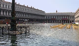
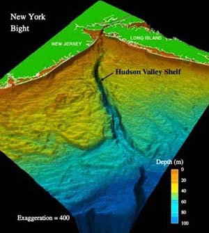
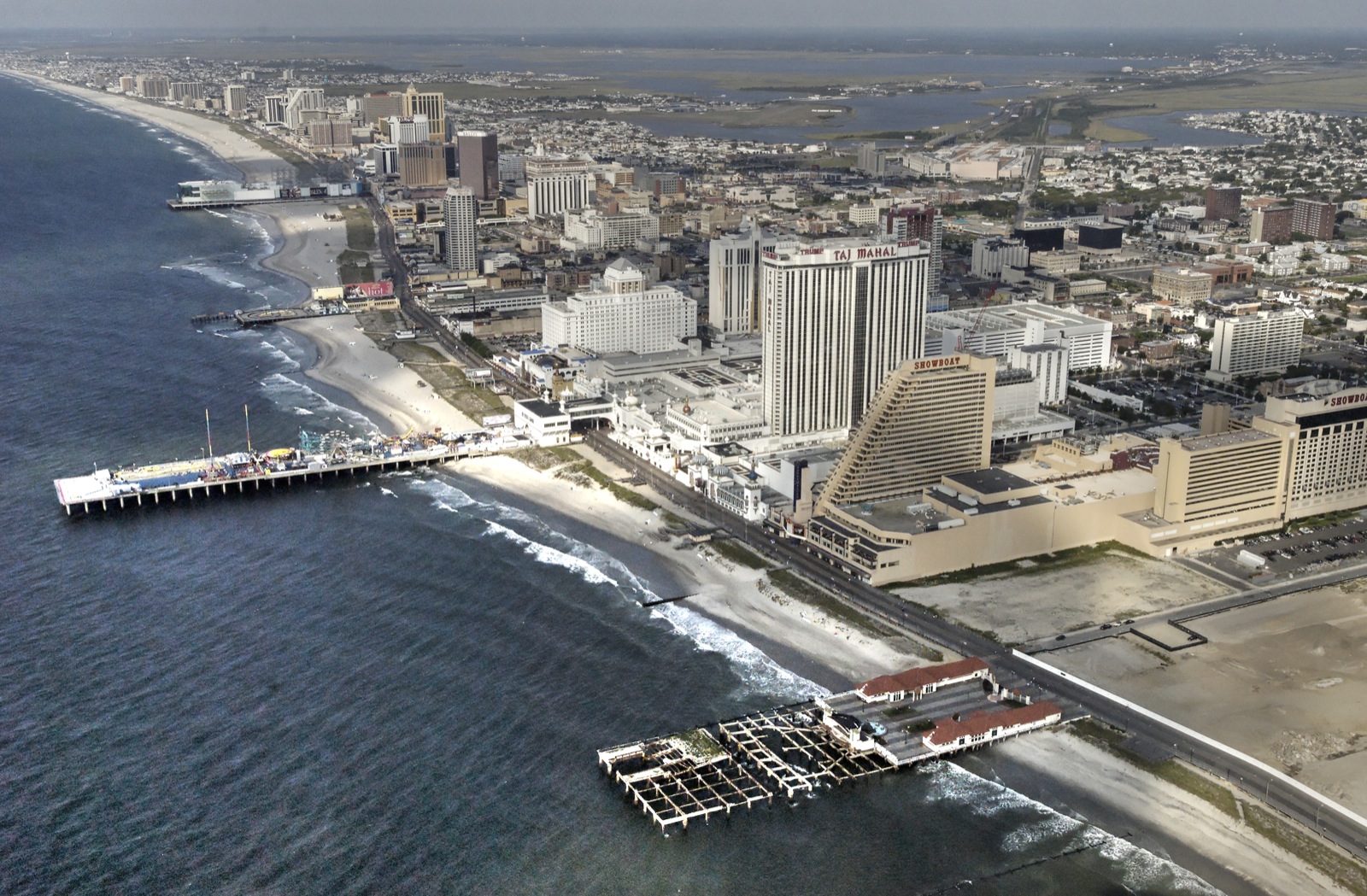
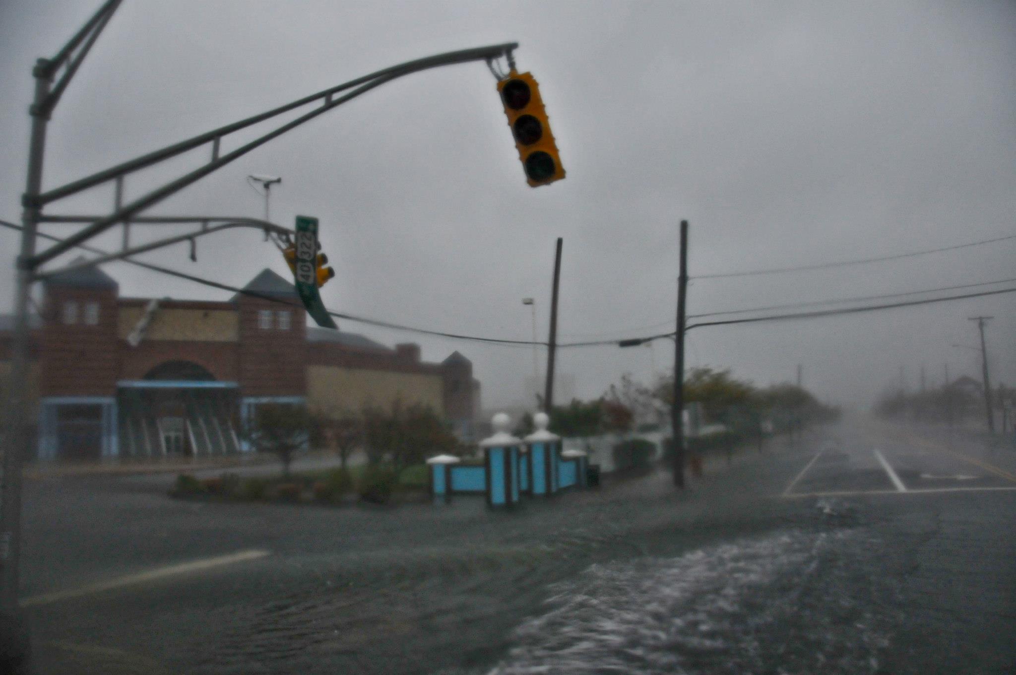
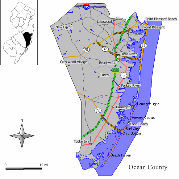
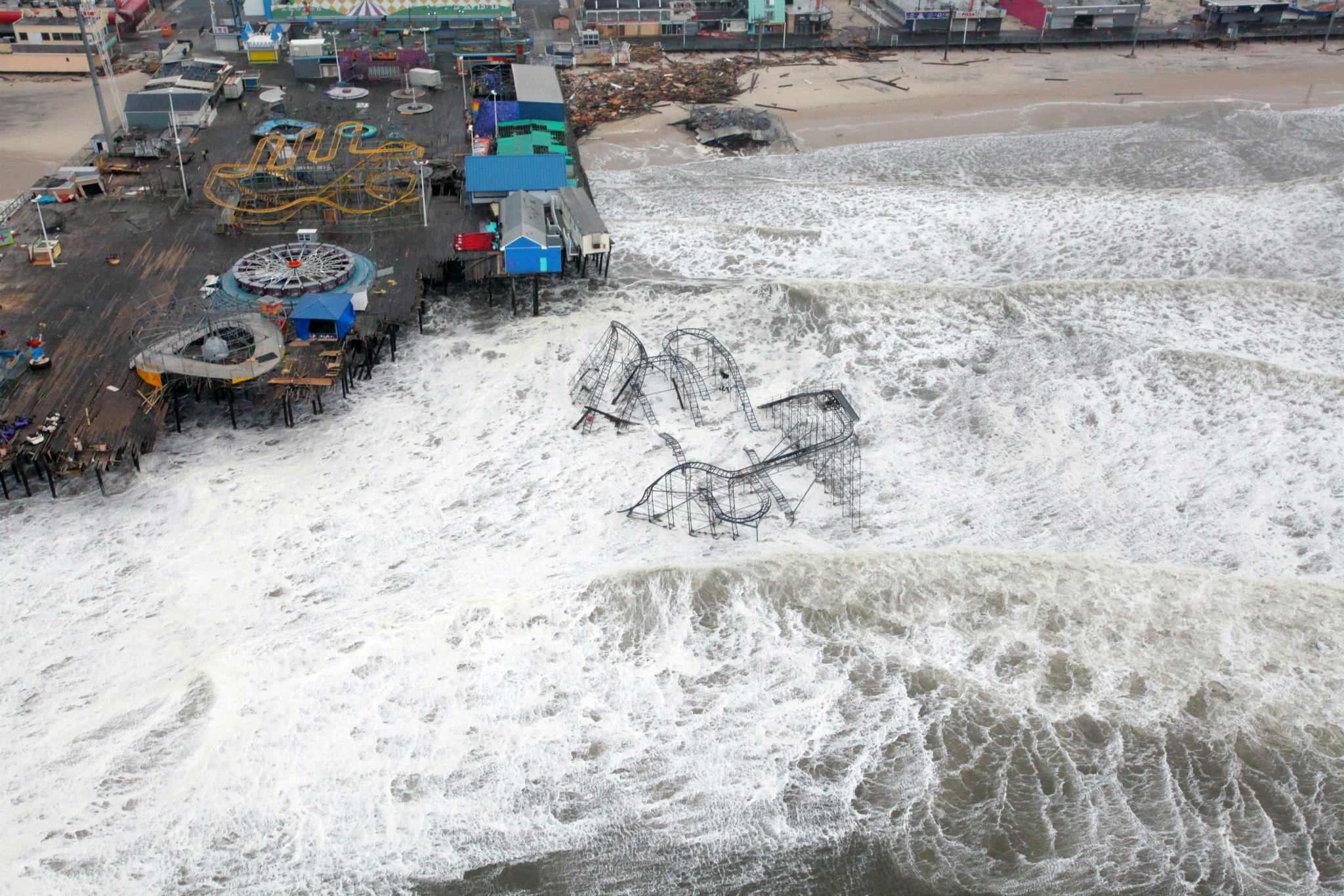
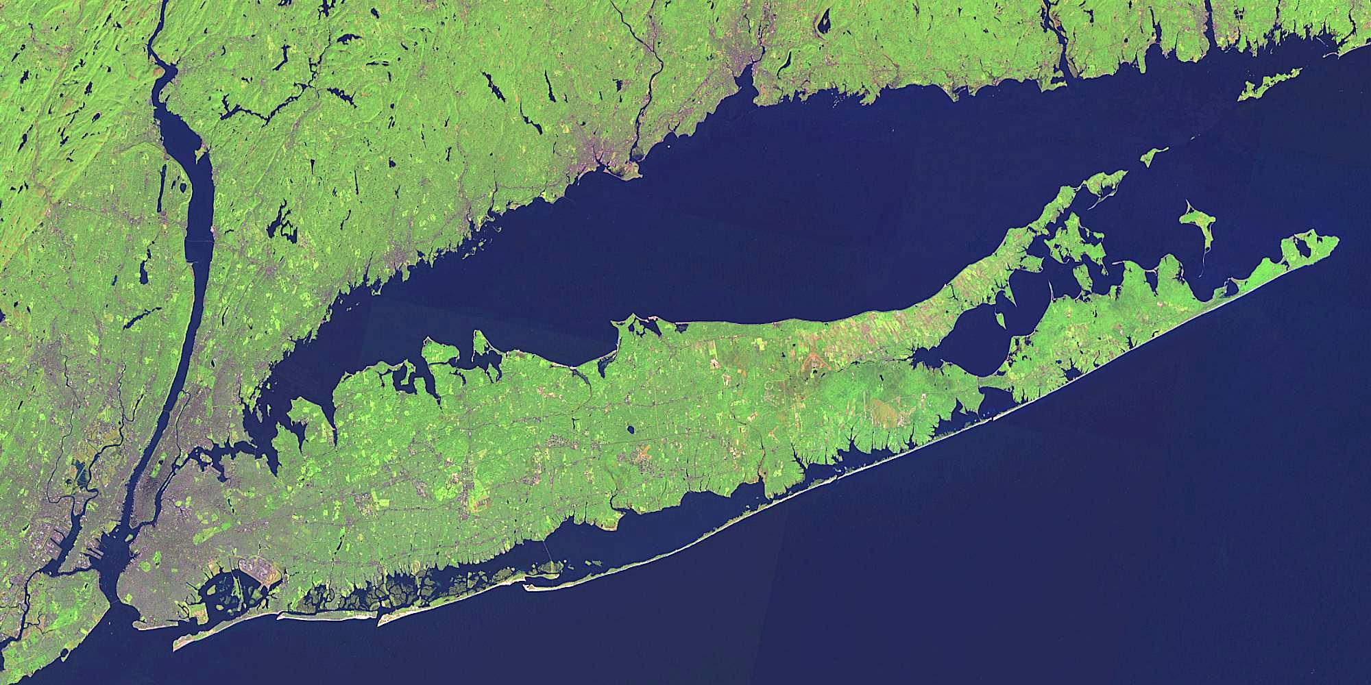
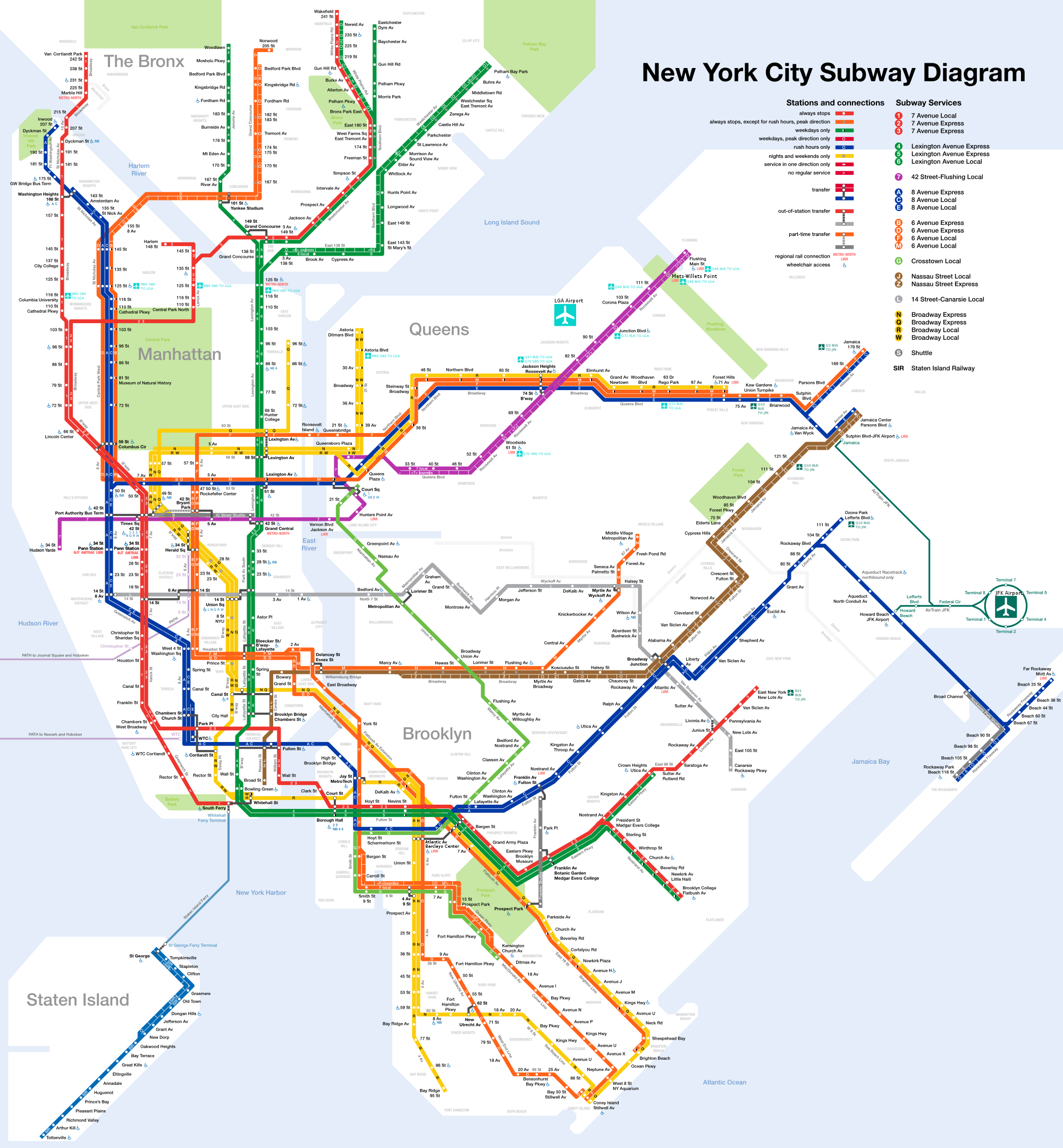
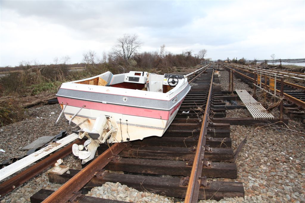
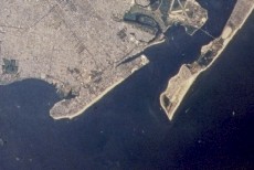
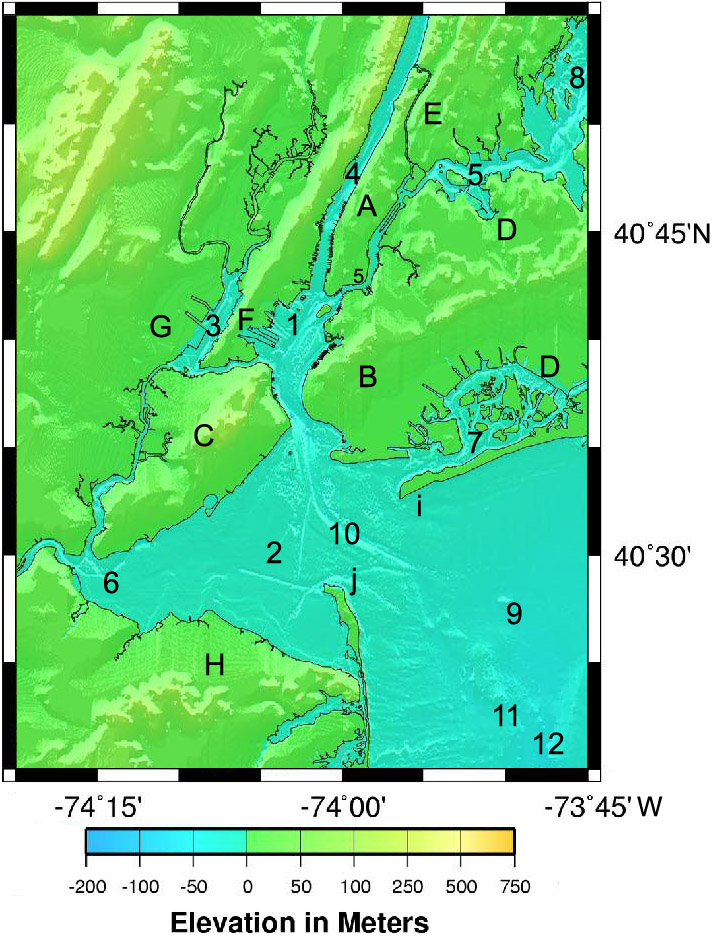
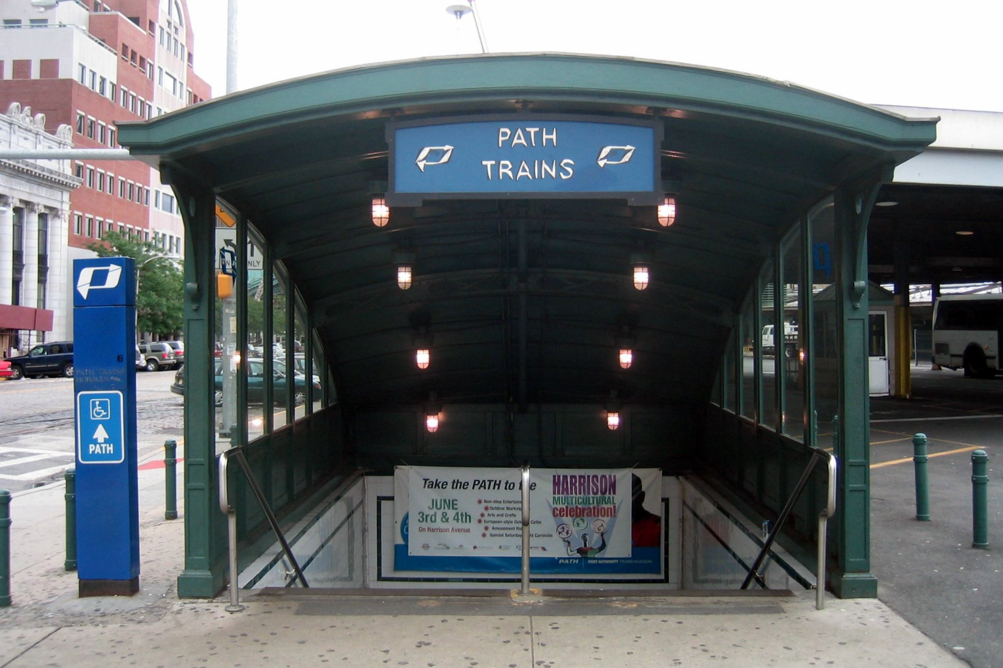
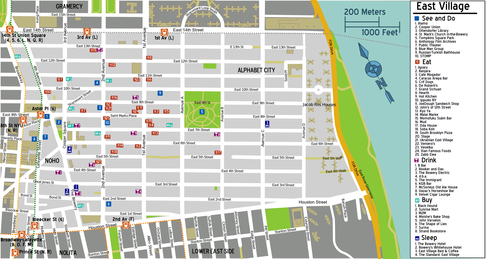
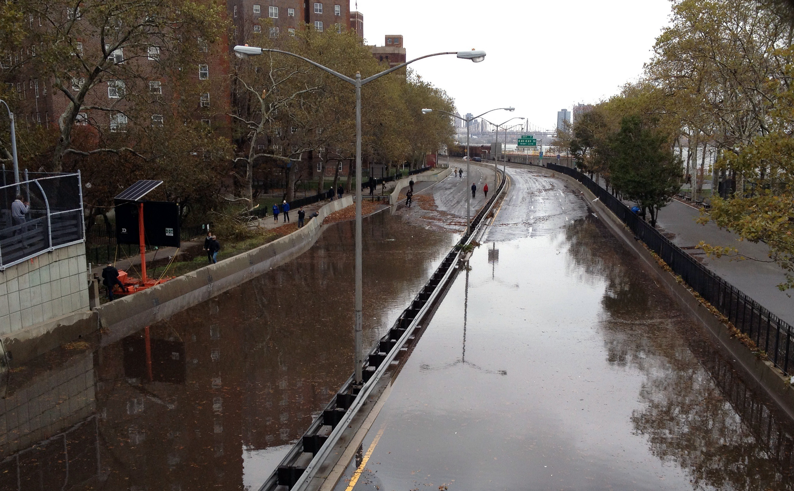