|
Reflections 2012
Series 23
December 15
Atlantic Isles VIII a: Greenland
| | As explained in the posting on Iceland (2012/21), the trip to Greenland will now be treated as a twelve-night side trip out of Iceland (Hafnarfjördur), after sailing from Iceland to Greenland on 16 June and then coming back to Iceland early on 28 June in order to fly home. Atlantic Isles VIIIa will first discuss the whats and wheres of Greenland in order to help clarify the next posting, VIIIb, the day-by-day adventures of the voyage. The posting after that will delve back into the Norse in Greenland, and in Vinland. | | | | Polar Climates Events are so unpredictable. Before this year, I’d had Greenland on the back burner for several years, waiting until the Deutschland got back on its feet and put Greenland back into its annual schedule. But I had no idea when that would happen, least of all last October-November when I went to Churchill (2011/25-29). As part of that, we discussed climate in 2011/26 as illustrated by the Köppen-Geiger system (Map by Peel, M. C., Finlayson, B. L., and McMahon, T. A., University of Melbourne). | | | | You can refer back to that Churchill posting for additional review, but the essential for now is that we had, all the way up from Winnipeg to Churchill, a Group D climate, deep green on the map, which was a Subarctic or Taiga Climate, with a taiga (treed) landscape, having a warmest month average temperature ABOVE 10°C (50°F). Still, in Churchill we did border on one of the Group E climates in light gray, a polar or arctic climate, this light gray one characterized by a tundra landscape of shrubs and grasses. | | | | Yet now, with colder Greenland, we leave the Subarctic D's entirely and move solely into the two Group E climates that are two shades of gray on the map. These are the Polar Climates, and both are characterized by year-long temperatures BELOW 10°C (50°F), so from here on in, when picturing temperatures, think downward. | | | | Look now with new eyes at the light-gray Tundra Climate, ET. Here the warmest month average is from 10°C (50°F) DOWN TO 0°C (32°F). You hardly see this anywhere near or in Antarctica, a small exception being what we experienced in Grytviken on South Georgia Island (2006/15). Other than at high mountainous elevations outside the Arctic, light-gray ET is mainly a phenomenon of the Arctic. Look at it all along the northern edges of Eurasia and North America, most highly concentrated in Canada. It's in Spitsbergen and somewhat in Iceland, but then check it out in coastal Greenland. | | | | But our gaze has to be drawn to the dark gray, the EF, which is ominously called the Icecap Climate. This is where year-round average temperatures are BELOW 0°F (32°F). It's found in only two places on earth, spectacularly all across Antarctica, and, in the only place in the Arctic, in inland Greenland. I stepped briefly onto the Antarctica icecap in 2006, and this summer, 2012, I stepped briefly onto the Greenland icecap. | | | | You can now picture Greenland, based on its two climate areas, as having cool summers, which we experienced, and cold winters. The terrain is mostly a flat but gradually sloping icecap (icesheet) that covers all the land except for a narrow, mountainous, barren, rocky coast, which is where the milder of its two climates is found and consequently where Greenlanders live, principally on the lower west coast. | | | | Ice When discussing Greenland, ice is probably the first thing one thinks about. Consider masses of ice in terms of "big, bigger, biggest", that is, glacier, icecap, icesheet. A glacier is a huge mass of ice slowly flowing over a land mass, usually down a valley. Massive glaciers can connect one to another over an area. Use as an analogy an open bucket of ice cubes where the cubes have melted together into one large clump of ice. Technically, if the connected glaciers, usually in a highland area, cover LESS than 50,000 km² (19,000 mi²), the result is called an icecap; if it's MORE than that, it's called an icesheet. While there have historically been huge icesheets across the earth—we discussed the Laurentide Icesheet over North America in 2010/25—the only current icesheets on earth are in Antarctica and Greenland. | | | | In everyday speech, people don't always differentiate so carefully, and frequently step down a reference. The Greenland icesheet is often just called an icecap, as Köppen-Geiger does and as I did several times above. And sometimes, an icecap is just called a glacier. Two "glaciers" we discussed in Iceland, based on the Icelandic word for "glacier", jökull, were Langjökull and Vatnajökull. In reality, these are large, and are actually icecaps. So, for our present discussion, Greenland has an icesheet (although I still may say "icecap"), Iceland has several icecaps (although they like to call them "glaciers"), and smaller ice masses are glaciers. | | | | | | As with "geyser" in Iceland (2012/21), where US “geyser” rhymes with “wiser”, but UK “geyser” rhymes with “freezer”, there's a US/UK variation in pronouncing "glacier": US "glacier" rhymes with "gray shir[t]", and UK "glacier" rhymes with "classier". |
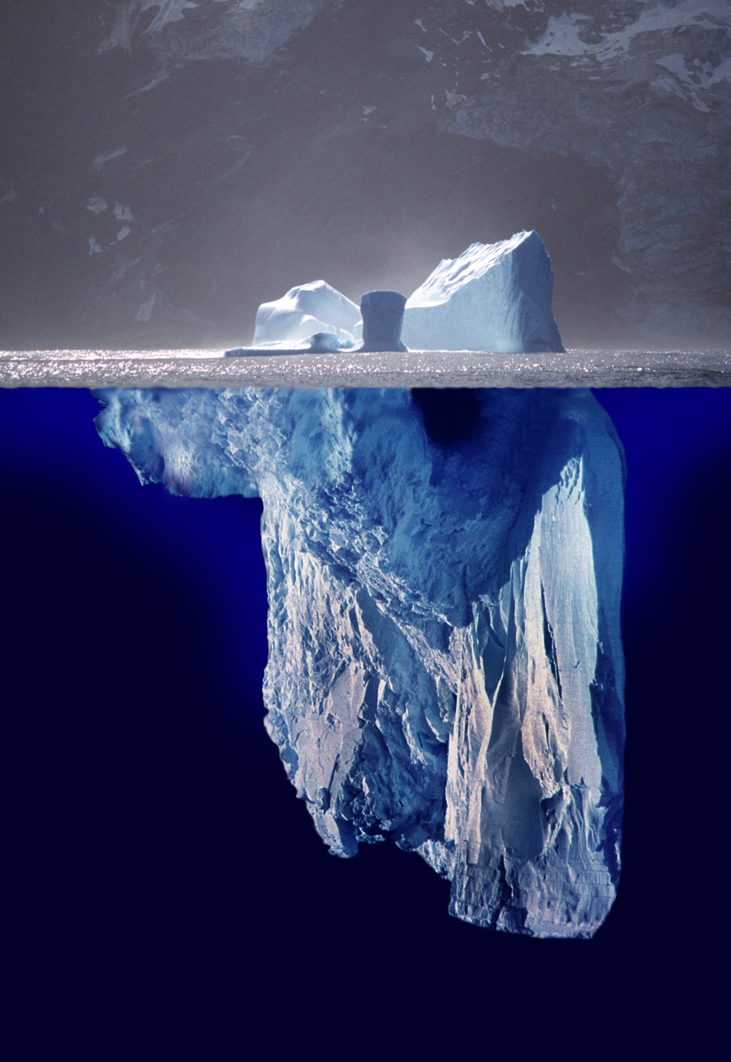
| | | | Greenland's icesheet (click to enlarge) (Map by Eric Gaba) covers about 82% of its surface. If melted, it would cause sea levels to rise by 7.2 m (23.6 ft). It's almost 2,400 km (1,500 mi) long, north-south, and its greatest width is near its northern end, which is 1,100 km (680 mi). Its mean altitude is 2,135 m (7,005 ft). It's 2 km (1.24 mi) thick on average, with a maximum thickness of over 3 km (1.86 mi). This is a satellite image of Greenland, clearly showing its icesheet. Since it also shows Iceland, seek out Iceland's largest icecap, Vatnajökull, as well as others, including Langjökull, furthest to its left. It also becomes more obvious why most Greenlanders live on the lower part of Greenland's west coast. | | | | Back to the basis of all these, the glacier: because it moves so slowly, many imagine it to be as solidly fixed as the land and rock it flows over. It can best be compared to honey moving slowly, especially in a cool room. Hold an almost-empty jar of honey at a tilt long enough and, although it will take "forever", the honey, because of its weight, will eventually twist and turn its way down the side of the bottle. Glaciers, too, because of their own weight, twist and turn over many years down a valley. | | | | "Accumulation" has as an opposite "ablation". When snow accumulates, if its rate of ablation is less than the rate of accumulation, any substantial remainder results in a glacier. Ablation is any process that removes snow, such as melting, evaporation, sublimation (changing state without an intermediate liquid stage), or simply wind erosion. And of course, calving. If a glacier reaches the sea, as it moves beyond the support of the land beneath, its face simply begins to crumble into pieces that fall into the sea and float away. Substantial calving can be accompanied by loud cracking or booming sounds, followed by hazardous wakes in the sea. This is a four-frame looped gif animation of a glacier calving into the sea. The analogy of a glacier calving is simply that of a cow giving birth to, or calving, a calf. | | | | Calving of Greenland's glaciers produce 12,000 to 15,000 icebergs each year alone. Most notable is the glacier just south of Ilulissat, from which constantly calve off, and pass out of the fjord, 35 billion metric tons of icebergs every year. More on that one later. | | | | When discussing glacial ablation through calving, now it's time to think "small, smaller, smallest", that is, iceberg, bergy bit, growler (yes, those last two are real terms). Huge as icebergs can be, I call an iceberg "small", as compared to the glacier it calved off of. An iceberg is, however, the largest size of a piece of freshwater ice calved from a glacier and floating freely in open water. I always assumed the word was a half-translation from German Eisberg "ice mountain", but now learn that I was slightly off, since it comes instead from Dutch ijsberg, which means the same thing (ijs rhymes with "ace"). It's almost the same in other Germanic languages (SW isberg, DA isbjerg), while many other languages use the English word. Since ice is less dense than sea water, famously only about one-ninth of an iceberg is above water (Photomontage by Uwe Kils and Wiska Bodo) as seen in this visualization, hence describing something as being "just the tip of the iceberg". | | | | Icebergs in the North Atlantic are all from Greenland, and primarily from Greenland's west coast, which means that, since most Greenlanders live there and that's where you see icebergs, the west coast is the area to visit. The biggest North Atlantic iceberg ever spotted was in 1958, and it was the height of a 55-story building. Sizes vary, and categories are not universal, but the International Ice Patrol breaks iceberg size down like this (height followed by length): | | | | | | VERY LARGE: over 75 m (246 ft); over 200 m (660 ft)
LARGE: 45-75 m (148-246 ft); 120-200 m (390-660 ft)
MEDIUM: 15-45 m (49-148 ft): 60-120 m (200-390 ft)
SMALL: 5-15 m (16-49 ft); 15-60 m (49-200 ft)
|
| | | | Floating ice masses smaller than that are still icebergs, but it seems odd calling such small things icebergs, so other terms have developed, bergy bit and growler: | | | | | | BERGY BIT: 1-5 m (3.3-16 ft); 5-15 m (16-49 ft)
GROWLER: less than 1 m (3.3 ft); less than 5 m (16 ft)
|
| | | | One is willing to give different sized icebergs due credit, but I've seen, in Glacier Bay in Alaska, in Antarctica, and in Greenland, these baby chunks of ice, the bergy bits maybe the size of a truck, the little growlers the size of a car or less. If you're moving slowly, the growlers can clunk into the boat underwater, which startles, but isn't serious. Here's another analogy: picture fresh ice cubes in your full glass as opposed to small remnants of ice cubes in your empty glass, which you don't take seriously anymore. It's not that different with bergy bits and growlers. | | | | I have two pictures of ice in the sea, and both are from the west coast of Greenland, but at the upper end, from Cape York, south of where Thule is on the map. The Deutschland didn't need to go that far, since there's plenty of ice to see further south, but look at this picture of glaciers and icebergs (Photo by Brocken Inaglory) at Cape York. Click to examine the faces of the glaciers, try to determine the sizes of the icebergs, and particularly, see the "slush" that you might consider a bergy bit or a growler. Then inspect this iceberg (Photo by Brocken Inaglory) at Cape York, click to see what weathering has done to it, but then see how it towers over some bergy bits and growlers. | | | | Size The next impression, after ice, that probably comes to mind is Greenland's size. Six world islands stand out for their size, in the following order, with a distinct drop in size before the next largest islands. These largest ones are Greenland, New Guinea, Borneo, Madagascar, Baffin Island, Sumatra. Aside from Madagascar, off the east coast of Africa, the rest fall interestingly into two groups. Three are in the East Indies, Sumatra being entirely in Indonesia and New Guinea and Borneo largely so. The other two, Greenland and Baffin Island (Canada's largest island), lie opposite each other in the north Atlantic, and are also culturally related within the Eskimo-Aleut culture. | | | | Greenland is the largest island in the world, as contrasted with Australia, which is the smallest continent. Of course, all continents are themselves islands (there are really just three, Africo-Eurasia, the Americas, and Australia), but their larger size puts them one category up. Australia is over three times the size of Greenland, so there's a good-sized differential between the two categories. Here is a same-scale comparison in size between Australia and Greenland (Map by Benjamin Hell), the smallest continent versus the largest island. Setting Greenland's size arbitrarily at 100, New Guinea weighs in at 37 (a big jump downward!), Borneo at 35, Madagascar at 28, Baffin Island at 24, and Sumatra at 21. Compared to Greenland, Australia would be 357.
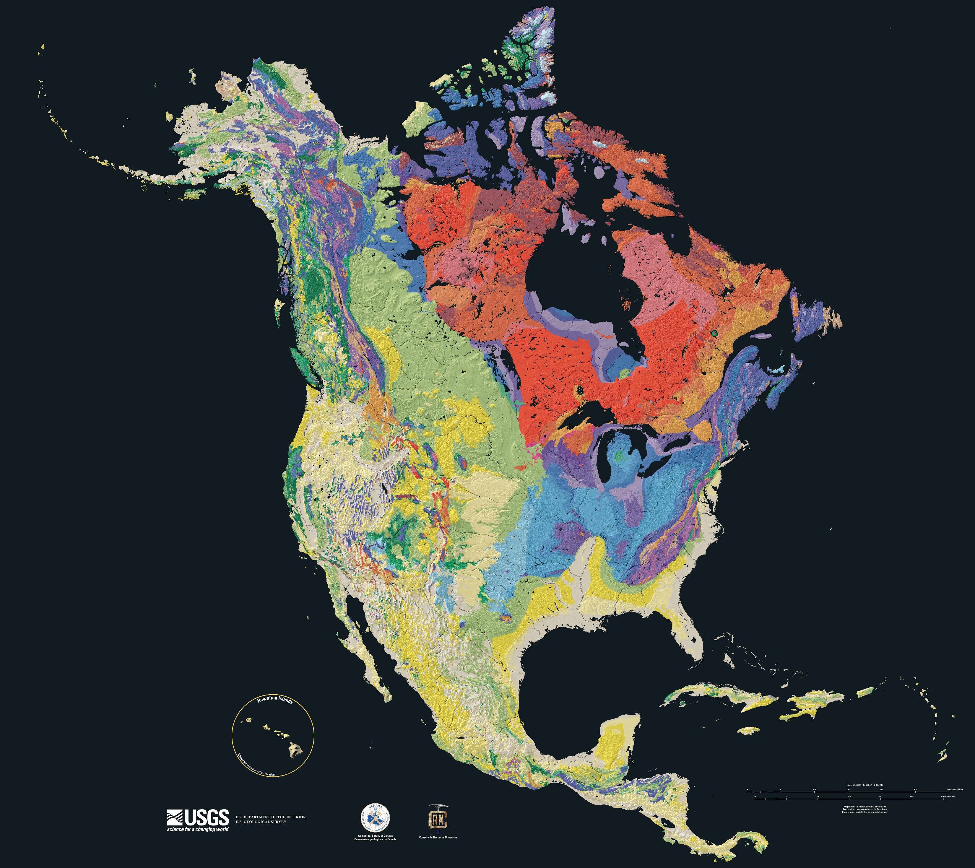
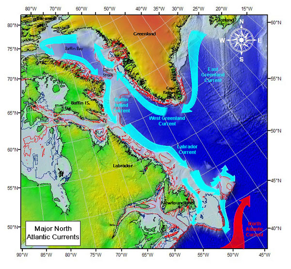
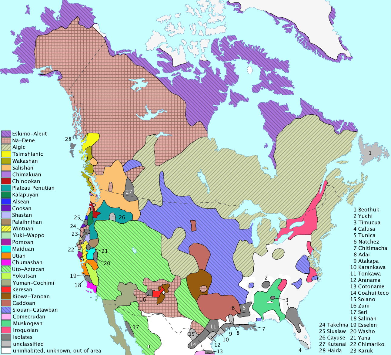
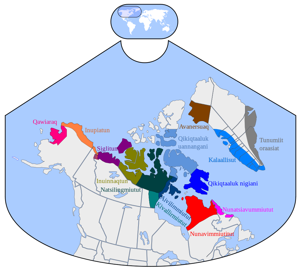
| | | | Location Just where is Greenland? Factual location and popular conception seem to disagree, another example of what I call dual reality. First, let's reconsider Iceland. Iceland, as we said, straddles the Atlantic Ridge, so that the western third of Iceland is on the North Atlantic Plate, technically making it part of North America. But, beyond the fact of that locational quirk, no one pays attention to that. Iceland is a European country for historical, ethnic, and cultural reasons, and beyond being European, it's specifically Scandinavian. Similarly, the Azores are fully European—and Portuguese—despite the fact that the two, small westernmost islands are also on the North American Plate. | | | | Greenland, however, is without a doubt geographically on the North American Plate, and any good map of North America will correctly show that. Follow the meridians, and you'll see that it has to be shown on a tilt because it's so far north. One should be very wary on a world map in a mercator projection, which will spread out Greenland so that it looks HUGE, far larger than it is. | | | | But this is where common conception differs. Most people visualize Canada as being the northern end of North America, and nothing else. Frequently, maps purportedly showing North America, will leave out Greenland, such as this geologic map showing North American bedrock and terrain, even including Caribbean islands, but forgetting Greenland. To paraphrase Rodney Dangerfield, "Greenland don't get no respect". | | | | This also shows up when it's said that the Norse, on arriving in Newfoundland (Vinland) discovered America, and that the child born there was a contender for the first European child born in America. Both these points implicitly reveal that Greenland, which the Norse settled centuries before, and where plenty of European children had been born, is simply not considered (North) America. Of course, so many of these things can be torn apart. Since Newfoundland is an island, just as Greenland is, did the Norse really discover America when they landed in Newfoundland? (Spoiler: they also stopped on the way in Labrador, on the mainland.) And Columbus, over four voyages also visited lots of islands, never setting foot on any mainland until he briefly stopped at South America on his third voyage, and Central America on his fourth. If we're going to include visiting islands in our concept of discovering America, just what did Columbus—and the Norse—discover, and just where IS Greenland, indeed? | | | | What causes the consternation is that, while Greenland is geographically and culturally (that is, the Eskimo-Aleut cultures) in North America, geopolitically it's been associated with Europe, dating from the Norse (Norwegians) who settled it from Iceland, and whose settlements disappeared, to the Danish, who later took over, and with whom the Greenlanders are now still associated politically. For instance, with one minor (but significant) exception to be discussed later, it's possible to fly commercially to Greenland only from Copenhagen and Reykjavik, and not directly from North America (minus that small exception). | | | | Still, to my way of thinking, Greenland "faces" west, in other words, Canada. That lower part of its west coast proves it. It's where most people live and where the capital is. It's where the Eskimo-Aleut people arrived from northern Canada to settle, it's where the ancient Norse settled until they died out, and it's where the Danes came when they took Greenland over. Now that the Greenlanders are shrugging off Danish influence, it's to related ethnic groups to the west where they seem to want to turn their attention. If you never had any concept of what was "front or back" in Greenland, this is a good way to look at it. | | | | A Sea and Two Bays Everyone realizes that the North Atlantic reaches two long arms eastward, the Mediterranean along southern Europe and the Baltic across northern Europe. Everyone is also aware that the North Atlantic reaches a long arm westward into the southern part of North America via the Caribbean and Gulf of Mexico—and there the symmetry seems to stop. Only in researching Greenland and its history did it occur to me that the North Atlantic also reaches a long arm westward across NORTHERN North America, but most of us pay little attention to it—just like we pay little attention to Greenland. | | | | The reason for this is that this area, the far North of North America, unlike northern Europe, which benefits from the Gulf Stream, is cold and its far reaches are blocked with ice, with the secondary result that it also has low population. Since trying to pass through that ice—finding the "Northwest Passage" from the Atlantic to the Pacific--has been for centuries the primary goal for entering these waters, that's the only real reason people think about this maritime area. | | | | But visualizing the two eastward and two westward arms of the Atlantic in their symmetry shows a parallel as we visualize the symmetry of Columbus's route westward from the Mediterranean area to the Caribbean area as contrasted with the Norse crossing from the Baltic area into the Labrador Sea and beyond. It's unusual to see both geography and history falling so neatly and symmetrically into place. | | | | Last November in Churchill we discussed the historic arrival of Westerners into Hudson Bay and in Churchill as well as modern freighters leaving Canada, except in winter, via this northern route. Now I see that the Greenland trip is simply using the other half of that maritime region. Let's look at the waters in question, which are all Canadian and Greenlandic. They consist, really quite simply, of one sea and two bays, with straits connecting them. For our historical and geographic purposes, we need to consider that the ice in those northern islands blocking passage into the Arctic Sea (or "Ocean" if you insist) is a valid practical phenomenon closing off the far end of this sea-and-bays area, just as the Baltic is closed off from further passage at its far end. | | | | Coming from the North Atlantic, we are between Labrador and Greenland, in the Labrador Sea. Straight ahead is that other major player in our list of islands, Baffin Island (Map by Connormah), the largest Canadian island in area and, with a population of 9600, more populous by far than any of the other islands in Canada's North, which have populations ranging from zero to a few hundred at most. (As you see Greenland and Baffin Island as "twin islands", as it were, unequal in size, but also culturally related, think ahead to understand why Labrador and Newfoundland were a logical destination for the early Norse in southern Greenland.) | | | | Encountering Baffin Island, we can turn to its left via the Hudson Strait and, ignoring the icy blockages to the north, turn again into Hudson Bay and to Churchill, or other destinations. Or we can go to the right of Baffin Island, essentially straight ahead, via Davis Strait into Baffin Bay, to another ice blockage at the far end. Thus the sea-and-two bays maritime region we have include the Labrador-Hudson route and the Labrador-Baffin route. I don't see how to refer to this entire maritime area by anything beyond calling it the Labrador-Hudson-Baffin region, which doesn't fall off the tongue as simply as Baltic, Mediterranean, or Caribbean. Perhaps just calling it the Labrador Sea is sufficient to imply the routes to the bays beyond. | | | | I'm pleased to say that I've stood on the edge of, and seen (but not sailed on) Hudson Bay on a brisk, sunny November day, and, while I have no personal experience with Hudson Strait or Baffin Bay, I sailed on the Deutschland on the Labrador Sea and Davis Strait, with some of those June days being quite sunny, mild, and pleasant, worthy of reading your book on a deck chair in the sun. | | | | We should mention early Western incursions into the area, including the people whose names we've just heard as place names. The early Norse, who settled the lower west coast of Greenland, came up as far as Disko Bay, halfway up the east coast, which is just what we did on the ship. The Norse had arrived in the late 900's and the colonies had died out by the early 1400's. The Danish arrived in 1721, but it was in between those dates, in the late 1500's and early 1600's that the explorers arrived who were searching for the Northwest Passage: Martin Frobisher (1576); John Davis (1585); Henry Hudson (1609); William Baffin (1616). | | | | Sir Martin Frobisher in 1576 became the first westerner to visit what is today Frobisher Bay in the southeastern corner of Baffin Island. The city at the inner end of Frobisher Bay was also called Frobisher Bay until 1987, when, as a sign of the times in both northern Canada and Greenland, its name was changed to the Inuit name, so the city is today Iqaluit. Given the larger population of Baffin Island as mentioned, Iqaluit, located on what is still Frobisher Bay, is the capital of the newest Canadian territory, Nunavut (Map by EOZyo), separated in 1999 from the Northwest Territories. I mentioned earlier that, with one exception, international air service out of Greenland is to Copenhagen and Reykjavik. The exception is the air connection from Greenland to Iqaluit, on Baffin Island, showing the importance of the cultural connection among the Inuit, even if it's presently only seasonal service in the summer. | | | | Davis Strait is named after John Davis, one of the chief navigators and explorers under Elizabeth I, who visited these waters in 1585. Both Hudson Strait and Hudson Bay are of course named for Henry Hudson, who sailed here starting in 1609. Both Baffin Bay and Baffin Island are named after William Baffin, who described the bay in detail in 1616. | | | | Finally, the importance of sea currents should be pointed out regarding this area. Note the currents that brought the Norse from Iceland to Greenland and up its west coast. They also visited Baffin Island and Labrador, and it becomes less of a surprise to see why the Vinland settlement was in Newfoundland. And perhaps the biggest surprise is to find out that icebergs that leave the west coast of Greenland are most likely to flow NORTH FIRST, and then to swing around to enter the Atlantic, most likely not from the Greenland coast, but from along the Canadian coast. It is possible that this was true about the iceberg that sank the Titanic (more in the next posting). | | | | First Inhabitants: the Inuit The name of the indigenous cultural and linguistic group across the north, from Siberia to Alaska to Canada to Greenland, is Eskimo-Aleut, the Aleut part being a reference, in the Aleut language, to the people in Alaska's Aleutian Islands, so we can put that half of the name aside for our purposes. The term Eskimo dates from the 1580's, and possibly derives from an Algonquian word, making it an exonym, an "outsider name" for these people. While most exonyms, such as "Finland" for "Suomi", are perfectly acceptable to the people involved, the exonym "Eskimo" is not, and is considered by many to be pejorative. The endonym, the "insider name" that they themselves use to refer to themselves, is Inuit, which has become the preferred term in general. While this word just means "people" in translation, translating it confuses the issue, and the name is best left in its original form. | | | | As elsewhere in the Americas, even the Norse that arrived as early as the 10C were latecomers, since Greenland had been inhabited on and off for perhaps 4500-5000 years by the Inuit. The present Inuit inhabitants, however, arrived in the 13C, while the old Norse colonies were still active and hadn't yet been abandoned, but before the Danes arrived later, in the early 18C. These arrivals are easiest to visualize in these four maps showing ethnic migrations to Greenland (Maps by Masae). The earlier Inuit arrivals are in green, the later (current) ones in blue. (The yellow and gold ones in Labrador and Newfoundland are another matter.) The Norse, in red, were in Iceland continuously over this period, but had their colonies in southwestern Greenland, over nearly five centuries, only in the center part of the timeline. The later Danish arrivals are not shown, since they came after this timeline. | | | | Very appropriate here is this historical map of native languages of northern North America (Map by Ishwar). Of prime interest to us here are the Eskimo-Aleut languages in purple across the top, but should also refer to the two language groups in and near Churchill: Na-Dene languages are also known as Athabaskan Languages, and Algic languages are also known as Algonquian languages, and include Cree, the predominant indigenous language in Churchill. Again, it's from an Algonquian language that it's thought that the term "Eskimo" came. | | | | The above map is described as historical since it reflects the earliest time of European contact. While most of these languages are still spoken in North America, the extent of their distribution has been profoundly affected—that is, reduced--by European contact. It's estimated that the number of Inuit speakers in Greenland is about 50,000, making it the largest concentration of Inuit, and Canada is second at about 35,000. Third place is taken by Alaska's 7,500 Inuit speakers (but that's out of a total of 13,000 Inuit living there). Fourth place, surprisingly, is taken by Denmark, where an estimated 7,000 Greenlandic Inuit live. There are only a few hundred Inuit speakers in Russia. That puts the global population of Inuit speakers at over 90,000 people. | | | | Kalaallisut Finally, we can get more specific about what's spoken in Greenland, which we now see as having the majority of Inuit speakers. This is the distribution of Inuit variants (Map by Asybaris01) across the Arctic in North America. Concentrate on Greenland's three dialects. For our purposes, we can dispense with the two minor ones right away. | | | | The population of Greenland is some 57,000. While some 12% of the Inuit speak only Danish, that leaves 88% who speak an Inuit dialect (but many if not most are bilingual in Danish). Of those, only 0.8 speak the North Greenlandic dialect, brown on the map, and only 6% speak the East Greenlandic dialect, gray on the map. Both of these reflect the low populations in those areas. The majority, about 92%, speaks Kalaallisut, or West Greenlandic, light blue on the map. This totals well over 50,000 people, making Kalaallisut/West Greenlandic the most populous in the entire Eskimo–Aleut language family. In fact, it is spoken by more people than all the other dialects of the family combined. Because of its size, it's the official Greenlandic dialect, and the only official language in Greenland since the official status of Danish was removed in 2009. And by the way, speaking of population: given the size of the icesheet, and the relatively small population living on the coast, Greenland is the least densely populated country or dependency on earth. | | | | I will have to admit something. When I got the itinerary of the half-dozen or so stops the Deutschland would make in Greenland, I was so unfamiliar with the names, names that seemed so difficult, that I thought I'd never be able to know where we were from one day to another. Names seemed like strings of the alphabet: we'd dock in Abcdefghi, move on to Jklmnopqr, and end in Stuvwxyz. It seemed that the names of cities could have been spam in my spam box. Not only wasn't it that bad, once I'd entered the various ports we'd be stopping at into my travel calendar—in other words, once I had to have a closer look at the names to copy them down—they very quickly became very familiar. While I do not know anything about Kalaallisut beyond a few facts I've read up on, I want readers to look closely at place names so that the narrative can be followed without readers having to think of a place as "the town that starts with S". No, that's Sisimiut, so let's work with these names to be able to recognize them. | | | | I have learned that Kalaallisut does not use stress, but does something similar to stress by using tones and long vowels. No matter. When I write Sisimiut as si.SI.mi.ut (rhymes with "brute"), I show how I perceive we outsiders would add our own stress, and my decisions are arbitrary, so stress it differently if you prefer something else. Same for Kalaallisut as ka.LA.lli.sut. Notice that two adjacent vowels are pronounced separately, and, as is typical for its language family, the Kalaallisut language has just three vowels, I, U, A, and by coincidence, the name of the language uses all three. | | | | Kalaallisut has both short and long vowels. Long vowels are written double, as in the capital Nuuk, which rhymes with "Luke". Presumably the long U in Nuuk is sounded longer than the short U in Sisimiut, although I'm sure westerners don't pay attention to that. The name Kalaallisut itself has both a short and long A. Ilulissat would be i.LU.li.ssat. Its double S indicates a long S, which is presumably hissed longer than either S in Sisimiut, but we can disregard that, too. Aasiaat, A.si.at has two long A's, so presumably it would be an imperfect rhyme with the end of Ilulissat. No matter for us. Paamiut would be PA.mi.ut, with a long A. After a while, you do get used to these names, and they no longer look like sequential alphabet letters. | | | | Then one hits the Q and panics. What do I do with Qaqortoq? You do the same thing as with qajaq, whether you realize it or not, which is actually a word we all know. Watch. We talked about this in Dubai, and will mention it again. | | | | Letter Q is an oddball. It’s used in the spelling systems of most Western languages only with U in the combination QU for various pronunciations: KW is written QU in English (quartz); KV is written QU in German (Quartz); in certain cases in the Italic (Romance) languages, the K-sound by itself is written QU (que). It’s very odd in Western languages to see Q without U, and might be found most notably in French coq or cinq. That's why the panic sets in in seeing a Q by itself elsewhere. But in non-Western languages that have two kinds of K-sounds, K is used for one and Q is used for the other, such as in Arabic (Kuwait as opposed to Iraq). Western speakers can disregard the K/Q distinction these languages make, and pronounce them both as K. Kalaallisut also has two K sounds and uses both K and Q, as in Nuuk, and, spectacularly, Qaqortoq. Just as you easily pronounce Iraq as i.RAK, don’t feel threatened by Qaqortoq, since it’s simply KA.kor.tok. | | | | Now we can continue with ease with the capital, on Baffin Island, of Nunavut in Canada, Iqaluit, i.ka.LU.it. We can even handle a longer name like Narsarsuaq, nar.sar.SU.ak. But I remember how nonplussed I was when I saw we'd stop at Kangerlussuaq. How do you remember a name like that? It became easier when I learned that "kanger" just means "fjord", and the rest then fell into place, so Kangerlussuaq is kan.ger.LU.ssu.ak. | | | | So what about that qajaq? How is that a familiar word we all know? The qajaq, which was used to hunt, was developed in northwestern Greenland, which was culturally a major area. The harpoon was also developed there, as was the dog sled (huskies are from Alaska, but the Greenland variety was developed locally). Since the spelling of qajaq startles the western eye, in the west we usually do the same trick of Q to K and get at first "kajak", a spelling always used in German and occasionally in English, but ja, ja, ja, it's usually spelled "kayak" in English. You knew at least a bit more Kalaallisut than you thought. | | | | There's another Inuit word everyone knows, the word for "house". Any ideas? If nothing comes to mind, it's because borrowed words more often than not come with restricted meanings. English speakers just KNOW that a sombrero is a large, broad-brimmed, highly decorated, Mexican hat, but are startled to find out that that restricted, very specific meaning only occurs in translation. In Spanish, a sombrero means any kind of hat, possibly a Mexican one, but just as likely a bowler or straw hat. That's why the Inuit word iglu, often in an Anglicized spelling, "igloo", is restricted in western use to mean a very specific house made out of blocks of ice, while in original use, an iglu is any house at all. | | | | I specifically said that iglu was an Inuit word, because there's a variation in Kalaallisut, where a combination like GL has assimilated to LL. Therefore, in Greenland, a house is an illu. So, with very little effort, we do know two Greenlandic words. | | | | Let's locate the place names on the map, which will help us with our Greenland geography as we discuss the visit in the next posting. You'll find everything of importance on the lower west coast. On this map we saw before, find Ilulissat; find the fjord right to its south with the Ilulissat glacier that pumps so many icebergs into Disko Bay, and also note how the icesheet abuts this area so closely. Disko Bay, which looks like a backwards-C, surrounds Disko Island, named simply for its round, disk-like shape, which is the farthest north Erik the Red ever came. Also on Disko Bay is Aasiaat. Further down the coast are Sisimiut and Nuuk. Inland from Nuuk is where the Norse had their old Western Settlement. Near the southern tip find Qaqortoq. This is where the much larger Eastern Settlement of the Norse was, relatively east, but not on the east coast, as the name might imply, and as some imagined, even back in the day. | | | | Not named on the map, but take a look anyway, is the southernmost tip of Greenland. I'd never heard its name before, and when the ship passed it, the captain mentioned the Danish name, Kap Farvel, and I managed to understand what it meant, and it really appealed to me. If the meaning hasn't struck you, you shouldn't be rhyming it with "marvel", but stress the last syllable, just as in the corresponding English word, and far.VEL might tell you that this is Cape Farewell. What a romantic name, separating East from West, a name that should be especially appealing to travelers. | | | | Not all the places we need are named on that map, so look at this map, which in turn, lacks some of the previous ones. Locate Paamiut down the coast from Nuuk. Up the coast from Nuuk, locate the town of Kangerlussuaq, way in, at the end of the long fjord of the same name. It shouldn't then surprise that Kangerlussuaq means "Long Fjord". Actually, Sisimiut is just barely north of this point. You may recall that we said there were only two, large international airports in Greenland, both left over from WWII installations. One is just inland from the tiny town of Kangerlussuaq. The other is at the tiny town of Narsarsuaq, inland from Qaqortoq, not shown on this map. | | | | None of the Greenland cities we've mentioned, or any others, are connected to each other by roads. There are still some water connections, but nowadays, everything is connected by air, either regular plane or helicopter. We've mentioned the international air connections to Copenhagen, Reykjavik, and Iqaluit. This is a map of the domestic routes of Air Greenland (Map by Algkalv), which will also help us recognize the Greenland cities we've mentioned. On Disko Bay, JAV is Ilulissat; JEG is Aasiaat. Also adjoining each other are JHS, Sisimiut, and, at the end of its fjord, SFJ, Kangerlussuaq. GOH is Nuuk, also on its own fjord. JFR is Paamiut, and UAK is the other international airport at a tiny town, Narsarsuaq, which is one of the helicopter hubs, this one also serving Qaqortoq. If you've been paying attention, these city names should no longer look like random segments of alphabet. | | | | More Background We just reviewed what exonyms and endonyms are, and that applies to Grønland, for which I've just used the original exonym, given by Erik the Red. That Norwegian and Danish name is the same in Swedish and German, with the alternate spelling for the vowel: Grönland. Other Germanic languages change the vowel entirely, such as English Greenland, Dutch Groenland, Icelandic Grænland. Other languages use the Germanic name in more radical variation, such as Italian and Spanish Groenlandia. But the name remains an exonym, and one that Greenlanders seem to mostly accept. But of course that means there's an endonym, a local name, which is Kalaallit Nunaat. The Inuit who speak Kalaalli(sut) are the Kalaalli(t), and so Kalaallit Nunaat simply means Kalaallit Land, which makes great sense. | | | | [By the way, it was Erik the Red himself who came up with the name Grønland, and if you've heard the story that he used the pleasant vision of greenery to embellish the image of the place in order to attract settlers, apparently you've heard right. While Greenland does have its beauty without a doubt, greenery at most is a minor part of it, so, given this "overenthusiastic advertising", I don't think it's going too far to say that what Erik was doing bordered on perpetrating an early land scam. At least it wasn't as bad as Florida in the 1920's. But then, Erik was apparently that kind o' guy. That's why there are no statues to him, but plenty to his son Leif Ericson.] | | | | We've talked about the Inuit arriving; as for the two separate colonizations of Scandinavians, we'll discuss the early Norse colonization in its entirety in a later posting, since that connects with the Vinland story. But why did the Danes arrive later on and take over? That's only very distantly connected with the earlier period. | | | | By the 18C, knowledge of the old Norse colonization in Greenland had become hazy, so hazy, that no one really knew that the colonies had died out entirely. The Norse involved had been Norwegians (and Icelanders), but by that time, Norway and Denmark were one country for a period of time, centered in Copenhagen. So it was Norwegian cleric Hans Egede in Bergen who started this later Danish movement to Greenland. Although his was presumably a cultural goal, that of reestablishing contact will fellow Scandinavians, it's quite interesting that he had an unusual religious goal as well. It had been two centuries since the Protestant Reformation had taken place; Egede was aware that there was both a bishop and cathedral in Garðar, in the Eastern Settlement, and he wasn't sure that the Reformation had reached Greenland! It's a fact that there were both pagan and Christian (read "Catholic") Vikings in Greenland, but the mistaken thought that the Vikings would still have been around long enough for there to have been Protestant Vikings strikes me as quite unusual. In any case, Egede felt that if he found them and if they hadn't yet heard about the Reformation and were still Catholic (or pagan), Egede would make sure there were indeed Lutheran Vikings! | | | | Egede, his wife, four children, and forty other colonists, including merchants, sailed from Bergen on 2 May 1721 on the Haabet (modern spelling: Håbet), meaning "Hope", plus two smaller ships. A secondary goal was mercantile, to revive trade with Greenland. On 3 July they reached the fjord that Nuuk is on today and established Haabets Colonie, or "Hope Colony". His explorations found no Norse on the west coast, where both colonies had been located, one further east than the other, and he was further misled by the common belief of the time that the larger, major Eastern Settlement was actually on the east coast, with a strait through Greenland connecting the two. Finally, in 1723, he did find the empty ruins, including that of the cathedral, of the Eastern Settlement, but since it was on the west coast, he thought he'd found the smaller Western Settlement. In any case, there were no Lutheran Vikings, nor would there be any. | | | | Nevertheless, his 1721 arrival in Greenland marked the start of the second Scandinavian period of the island, the present Danish one. His colony grew, so he's credited with founding Greenland's capital, Godthåb ("Good Hope"), now renamed Nuuk. Commercial connections were established. While he'd found no Norse, he did find the Inuit, and began studying their language, establishing a successful mission among them. Missionary work always involves some cultural and language clash, and some maneuvering is required to solve problems that arise. The Inuit had no bread (wheatfields in Greenland?) and no concept of what bread was, which resulted in Egede's translation "Give us this day our daily seal". | | | | Greenland became a Danish colony, and later a province of Denmark in 1953. In 1979, Greenland was granted home rule, and, with the Faroes, became part of the Danske Rige/Danish Realm (see 2012/18 "Faroes"). At this point, Kalaallisut became an official language, along with Danish. In 1985, Greenland withdrew from what was then still called the European Economic Community, in order to maintain control of fishing in its territorial waters, demonstrating one more break with Europe and potential turn toward North America. | | | | In 2008, a referendum was held on self-government. To understand the enthusiasm, note that there was a 72% turnout, and the referendum was passed with 75% approval, although there was somewhat less approval, 63%, in Nuuk, with its larger Danish-speaking community. This was when Danish was removed as an official language. Thus, on the 30th anniversary of home rule, in 2009, more power was transferred from the Danish Government to the Greenlandic government. It's in effect a separate country, with local control of health care, schools, and social services, but with formal ties to Denmark, which remains responsible for its foreign affairs. | | | | Of the 12% of the Greenlanders who speak Danish as their first or only language, those individuals are concentrated not only in Nuuk, but are in the higher social strata, and fill upper-level positions, such as academics, professionals, administrators, or skilled tradesmen. The result is that Danish is still widely used in administration and in higher education. Just what role the two languages shall play in Greenland's future continues to be debated. | | | | There is also talk of full independence from Denmark, which is encouraged by Denmark, but held back by the need for economic subsidies in Greenland. Some have proposed 2021 as a date for potential independence, since it will be the 300th anniversary of Egede's arrival in 1721. | | | | Signs of Cultural Shift I find it very interesting to follow the various steps being taken that have moved Greenland away from Europe and perhaps even toward North America. Other than the obvious governmental shifts of home rule followed by self-government, there are the other things, such as the earlier cutting of ties to the EEC and the initiation of flights for the first time to Iqaluit in Canada. | | | | CITY NAMES A very visible cultural change was the replacement of all the old Danish city names with Kalaallisut ones. Godthåb ("Good Hope"), despite its poetic image and all its historic associations to Egede's colony, became Nuuk ("The Peninsula") in 1979, along with home rule. Presumably the other changes happened at about the same time. You've seen the other old Danish names in parentheses on the maps, and we'll look at the ones for the cities we've discussed. Similar to Godthåb is Paamiut's old name, Frederikshåb, "Fredrick's Hope", and Qaqortoq's, Julianehåb, "Juliana's (??) Hope". Sisimiut was Holsteinsborg, "Holstein Castle". Havn is "harbor" or "port, so Ilulissat's name, Jakobshavn, was something like "Jacobsport". Particularly poetic was Aasiaat's former name, Egedesminde, or "Egedes Memorial". Strøm is "stream" or "current", so apparently the old name for Kangerlussuaq ("Long Fjord"), Søndre Strømfjord, meant something like "Southern Streamfjord", as far as I can tell. Narsarsuaq is apparently small enough not to have had a Danish name. | | | | DROPPING DANISH Historically, colonial languages may become unofficial, but the don't disappear. English still prevails in Nigeria, French in Algeria, Portuguese in Angola, so now that Danish is no longer an official language in Greenland, it still might be around for a long time, even as more English is taught. For the traveler, it's always easier to recognize a European phrase, in this case even a Scandinavian/Germanic phrase, than an Inuit phrase. Look at this bilingual sign (Photo by Makemake). Obvious from the international symbol is that there's no parking, but many signs have no such symbol, so see what you'd have understood, and also just why it means what it does. The Danish says "Parkering FORBUDT for alle køretøjer". Only one word is totally different, and its meaning can be implied. The rest says "Park//ing FORB/// for all/ /////////", which is easily recognizable as "Parking FORBIDDEN for all ///////", and the last word must mean "vehicles", which it does. In the Kalaallisut version, all you can recognize is "motor". Even if Danish does disappear on signs and is replaced by English, the Danish version still offers guidance. | | | | THE FLAG There is little that's more symbolic of a change in national philosophy than a change in the flag. Right after home rule started in 1979, a committee started collecting design proposals. Two obvious design factors one would expect were the Nordic Cross (2012/18) and the color green. | | | | You may recall that all the Scandinavian countries, even Shetland and Orkney, which are now Scottish, even Finland, which is not Scandinavian, but only has a Swedish minority, exhibit a northern unity by having Nordic Cross flags (Image by Endrick Shellycoat) in local color variations. These flags are either two-colored, with a cross-on-field (four flags) or three-colored, with a cross-on-field, plus a thin edging on the cross (five flags). In this vein, one proposal for Greenland was a green cross on a white field; one was a white cross on a green field; one was the latter, but with blue edging on the cross; one was exactly the same as the Danish flag (Image by Madden), a white cross on red field, but with green edging on the cross. | | | | None of those won, although the white cross on the green field came in a close second. In other words, the committee rejected the two features you'd expect. Presumably they rejected the Nordic Cross to reflect a further distancing from Europe. But they rejected the color green entirely. My interpretation is that it's not that Greenlanders have anything against the exonym Greenland—the airline is called Greenland Air—but they want to stop identifying so deeply with Erik the Red's little joke-cum-scam. There are other colors and images that define the country, and that's what they ended up choosing. | | | | The winning design came from a local Inuit who was a teacher, artist, and politician, all of which seem to be the right background for this particular task. The flag was officially introduced on 21 June 1985, Greenland's National Day. This is Greenland's new National Flag (Image by Jeffrey Connell). | | | | If the design doesn't enchant you immediately, it will as you study it, and you'll see how perfect it is for Greenland. Its modern, minimalist design consists of just a horizontal line and a circle, with two colors. The line is the horizon, separating sky and sea, and also forming two semicircles. The upper semicircle is the sun, perhaps the midnight sun down on the horizon, or any rising or setting sun. The red is the glow of the rising or setting sun, also reflected onto the sea. The white background symbolizes the icecap and glaciers, and the white semicircle symbolizes icebergs and pack ice in the sea, all within the reflection of the sun. | | | | Not a bit of green. Still, while red and white do symbolize Greenland so well, in an hommage to Denmark, red and white are also the colors of the Danish flag. | | | |
| |
|
|
|

