|
Reflections 2014
Series 11
July 31
China XIX: Silk Road & Marco Polo Redux - Xi'an I – Terracotta Army
| | On recent reflection, I discovered I'd undergone a change of outlook about Eurasia, particularly after writing so much about China. When I wrote about both the Silk Road and then Marco Polo in 2009/33, I fully felt my stance had me knee-deep in the Mediterranean, and my mental imagery was of Silk Road merchants, and later Marco Polo, GOING to China, way over in the distant and hazy East. But now that I want to briefly bring up those two subjects again, I find my stance has reversed itself. I now find myself instead perched on the edge of the Tibetan Plateau watching Silk Road merchants, and later Marco Polo, leaving the distant and hazy West and COMING to China, passing right below me on my perch. I just can't shake that imagery from my head—and there's no reason I should. Does that mean I've grown culturally and have become perhaps a bit less provincial (read: Eurocentric)? But then, of course, that's the purpose of travel and the related cultural study. Since we spoke of these subjects earlier from the point of view of the West, we should all now stand on the Tibetan Plateau and watch the historic traffic parade by below us.
| | | | Silk Road Redux A brief recapitulation: what's called the Silk Road (or also Silk Routes, since there were also maritime routes around South Asia) was primarily a 6,400 km (4,000 mi) network of interconnecting roads, or caravan tracts from the Middle East to China. It was in use very roughly for about two millennia, between about 500 BCE to about 1450 CE. It was the main route for transporting commercial goods, skills, knowledge, and religion between West Asia (better known as the Middle East) and East Asia, and many places in between, including India. Its use came to an end when the Ottomans took over Constantinople. They were anti-Western because of the Crusades and because of the loss of Spain, and embargoed trade with the West, putting a fatal squeeze on the Silk Road. So we see that sic transit gloria mundi doesn't only apply to modern loss. (Is Sick Transit a pun here?) | | | | The reference to silk in the name points out the importance of that item from early on. But the name is only about a century old. It was coined by a German geographer named Ferdinand von Richthofen in 1877 as Seidenstrasse, then was translated into Silk Road, Route de la Soie, Ruta de la seda, Via della seta, and so on. | | | | Contrary to what I'd believed, most merchants didn't travel end-to-end, only their merchandise did. Most trade was done locally by middlemen, for a fee. Goods might be sold or bartered again and again, as they passed between merchants. Obviously, silk was one item traded westward, but so were paper, spices, furs, jade, tea, bronze sculptures, gunpowder, compasses, lacquered goods, and ceramics. Traded eastward were horses, ivory, precious metals (gold) and stones (jade, lapis lazuli), wool rugs, tapestries, jasmine flowers, frankincense and myrrh oils, herbal medicines, glass, sandalwood incense, cotton, yaks, camels, peacocks, and elephants. Buddhist missionaries and pilgrims, particularly from India, traveled the Silk Road, as did musicians, allowing a dissemination of national musical styles and instruments. | | | | This is an excellent German map of the Silk Road (Map by Captain Blood, Revised by Kelvin Case). If you'd rather study it in a separate window, here's the direct link:
http://upload.wikimedia.org/wikipedia/commons/b/bf/SeidenstrasseGMT.JPG
| | | | It doesn't show the Mediterranean water routes, but it shows in green (click) a few land routes connecting some major cities in the Middle East. A main route of the Silk Road is then in yellow, but this has to be something of a generalization, a summary of the caravan trails that connected oasis towns around deserts and mountain ranges across Central Asia. A prominent stop was the oasis city of Kashgar, today at the western end of Xinjiang Uyghur AR, and when we come to Kashgar on the map we enter our current zone of interest. | | | | We find ourselves entering the Tarim Basin at Kashgar, which, as we've seen, encompasses the Taklamakan Desert. No one wanted to cross that, so the route split two, actually three ways. The southern route went along the mountains at the edge of the Tibetan Plateau, right where we're sitting looking down on those merchants millennia ago. North of the Basin are the Tien Shan (also Tian Shan) Mountains. These mountains today form a modern border. On this side it's the Uyghur AR, but on the other side, Almaty and the area north of it is in Kazakhstan and that lake south of it is in Kyrgyzstan. You'll see in a moment why I mention the modern borders. Anyway, the northern Silk Road ran south of the Tien Shan, and afterwards near Ürümqi, the modern capital. But there was a central route that started in the north, but then cut across to the southern route until all three routes came together again. | | | | | | In 2014/9, we said they are thinking about three northward extensions of the route of the Tibet train, and on this map of ancient towns along the Silk Road, we can find all three modern rail destinations. Out of Golmud one extension is planned to Korla, and another to Dunhuang across the Qaidam Basin (in brown), and out of Xining (not shown), an extension may go to Zhangye. |
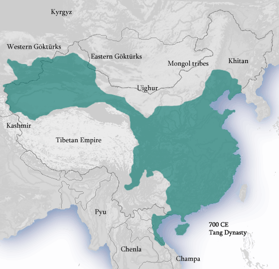
| | | | Note how, after Anxi, the Silk Road squeezes between the Tibetan Plateau on the south, and a the Huangtu Plateau and the Gobi Desert on the north. This is the historic long and narrow Hexi Corridor (X=SH) in long and narrow Gansu Province (Map by TUBS), also called the Gansu Corridor. When we first started studying China and its provinces, I'd noticed the long nature of Gansu, reaching out to the Uyghur AR between Inner Mongolia and Qinghai/Tibet AR, and got suspicious it may have taken that form because of the Silk Road, and was pleased to find I'd guessed right. This is further borne out by this map of China in the Tang Dynasty c700 CE (Map by Ian Kiu), where it's perfectly clear that, once China had acquired the Tarim Basin, China proper was connected to it by the Hexi Corridor—and the Silk Road.
| | | | Surprisingly not shown on our main Silk Road map is Xining, it having been a commercial hub for 2000 years. Xining was the chief commercial hub of the Hexi Corridor. The Corridor is considered to run 1000 km (620 mi) from the mountain pass known as the Jade Gate on the Xinjiang/Gansu border, all the way to Lanzhou, the modern rail hub we discussed when talking about the Tibet train. | | | | I find it of particular interest that the Chinese took such great interest in the safety of goods and merchants on the Silk Road so that they extended the Great Wall to it (see map) to ensure its protection. The narrowest point of the Hexi corridor is at Jiayuguan Pass near the city of Jiayuguan (see map). The Jiyaguyan Fort was built there and it's the first fortification on the Great Wall of China in the west. At the time, it guarded the western entrance to China. | | | | The major destination of those coming to China on the Silk Road was its capital at the time, Chang'an (see map), later destroyed and today using Xi'an as an overlay. The green routes show further connections via Luoyang to Beijing and via Nanjing to Hangzhou. | | | | | | China has many ancient cities dating to the BCE period (= BC). It's worth mentioning the three oldest, all from earlier than 1000 BCE. Their age stands out particularly because fourth place is taken by a "young" city from only 514 BCE. The oldest are Luoyang c 2070 BCE, Xi'an c 1100 BCE (as Chang'an on some maps), and Beijing c 1045 BCE (as Peking on some maps). |
| | | | This Silk Road summary was to have ended here, except I just found out some amazing news. UNESCO has decided it's time to establish the Silk Road UNESCO World Heritage Sites. That's "sites", in the plural, because it's been decided that the route is too long, covers too many countries, with too many historical sites along the route, to accomplish designation as one single unit, so it will be done in sections, to be referred to as Corridors. Countries have to apply to UNESCO for designations, as did Canada for Red Bay in Labrador, which by chance I visited on the day it was designated, to great local jubilation (2013/12). In December 2011, China, Kazakhstan, and Kyrgyzstan agreed to apply together as a unit, for the designation of one corridor from central China to just beyond the Tien Shan Mountains into the two other countries. Just about a month ago, on 22 June 2014, UNESCO designated a stretch of 5,000 km (3,000 mi) a World Heritage Site under the name Silk Roads: the Routes Network of Chang'an-Tianshan Corridor. UNESCO expects additional Silk Road Corridors to be added in upcoming years. | | | | Within this Corridor are 33 newly designated sites in the three countries covering cities, palace complexes, trading settlements, Buddhist cave temples, ancient paths, posthouses, mountain passes, fortifications, tombs, religious buildings, and sections of the Great Wall. The Corridor is further characterized by four regions along the Silk Road: 1) Central China; 2) Hexi Corridor; 3) North & South of the Tien Shan Mountains in the Xinjiang Uyghur AR; 4) Specified valleys in Kazakhstan and Kyrgyzstan. | | | | In addition to the Hexi Corridor Region, where Dunhuang and Anxi are further specified by name, I'm very excited about two of the named designations within the Central China Region. One is Luoyang, because it's the oldest city in China, and the other is "temples and palaces in Chang'an/Xi'an". Further specified by name within this last category are two temples in Xi'an, the Great Wild Goose Pagoda, which I visited, and the Small Wild Goose Pagoda, which I saw from a slight distance. It was at the former that I bought my ceramic Guardian Lions, and I'm greatly pleased by this turn of events. | | | | Marco Polo Redux We also discussed Marco Polo in 2009/33 and could use a brief recap here of him as well. He fits in to the Silk Road epic in that he was a (Venetian) merchant(-cum-explorer), as were his father, Niccolò Polo and uncle Maffeo Polo. His two elders had gone to China before, and returned to Venice in 1269. After staying home a couple of years, they then left again for China in 1271, but on their second trip, they took along the 17-year-old Marco on what turned out to be a 24-year, 24,000 km (15,000 mi) trip, of which 17 years were spent in China. It was just the three of them on the trip, and they returned to Venice in 1295. They returned to the court of Kublai Khan, who the father and uncle had visited on the first trip. It was because Marco Polo wrote about this trip that it's become so famous. In any case, their late 13C trip took place before the Silk Road declined in the mid-15C. | | | | Let's look again at the route of the Travels of Marco Polo (Map by historicair) with his elders between 1271 and 1295. What has intrigued me since the first posting on the subject is that, while we surely picture Marco Polo crossing Asia on the Silk Road, that was not his route of choice. If you recall, after they first sailed the Mediterranean to the Middle East and then crossed it overland, they went to Ormuz, located at the Strait of Hormuz in Persia/Iran, but could not find a seaworthy ship to travel the maritime section of the Silk "Routes". It was only then that they relented and traveled the Silk Road across Central Asia by horse and by camel. We recognize their stop in Kashgar at the beginning of the Tarim Basin, do not know which of the three routes they took across the Basin, but then watch them, below our feet as we observe from the Tibetan Plateau, cross the Hexi Corridor all the way to Lanzhou, then move on to Beijing. During their years in China they make side trips, including to Karakorum (today in ruins), the capital of the Mongol Empire, and all the way to Pagan (modern Bagan) in Burma. On leaving China after many years, the finally manage to take the maritime route back, resulting in, if not an actual circle trip, at least a "lollipop" trip to China. And all this we observe from our new point of view in East Asia. | | | | In Historic Footsteps From our vantage point on the Tibetan Plateau, we'll rejoin the Tibet train coming down from Lhasa. When we're back in Xining we're in the former Silk Road commercial hub (not shown on map). Then our train is in the Hexi Corridor, so that we're essentially following the route of the Silk Road, whose caravan tracks would have been somewhere adjacent. We stop in Lanzhou, today having grown into a rail hub, and either stop in, or pass through, Tianshui and Baoji on the way to Xi'an, the former Chang'an, stringing a series of Silk Road pearls onto our necklace. Think of those merchants centuries ago who traveled both ways on this route, including Niccolò and Maffeo Polo, and of Marco Polo who passed by just once, but in our direction. I'm now gladder than ever that I'd scheduled a visit to the Great Wild Goose Pagoda in Xi'an. I did it because it was a general cultural icon, but didn't realize that it was such a Silk Road icon as well. During the latter part of this train ride down from Lhasa we're figuratively walking in historic footsteps. | | | | Xi'an Our destination (as Chang'an) is not only a Silk Road icon, being its eastern terminus, it's also the second oldest continuously inhabited city in China after Luoyang, which is almost twice Xi'an's age, and just before Beijing, close behind Xi'an. Xi'an is also the capital of Shaanxi province. Don't be afraid of its apostrophe. In pinyin writing, the apostrophe is simply used as a syllable separator. If you like, picture it written as Xi-an instead, since that would be the same thing. It shows that you pronounce the word in two syllables. Although it wouldn't necessarily be the case that it has a twin, it actually does, and xian without the apostrophe is another word, pronounced as a single syllable, perhaps something like SHYAN, rather than SHI.an. We've seen the apostrophe in the alternate name of Golmud, Ge'ermu (so you know its three syllables), and the apostrophe seems to like to stalk the word an, also appearing in Chang'an and Tien'anmen. | | | | Talking about Xining we said that its name and Xi'an are both translated as "Western Peace", perhaps with two different nuances of meaning. But Xi'an has had a number of names over the years. Apparently the earliest was Fenghao when the area was a pair of twin cities, Feng and Hao, separated by a river. (Perhaps that reminds you of Buda across the Danube from Pest, eventually joining together to become Budapest.) Fenghao then became Chang'an, "Perpetual Peace", but when the capital was moved further east to Luoyang, Chang'an was also referred to as Xijing, "Western Capital". It then became Dajing, then Chang'an again, then Fengyuan, Anxi, and then Jingzhao. During the Ming Dynasty is when it finally took the name Xi'an, in 1369. which remained until 1928. But in 1930, the name reverted once again to Xijing, but only until 1943, when the Ming name Xi'an was brought back. It makes you dizzy. | | | | Personally, I like Xijing as a name, since it is so parallel to two other capitals, Beijing and Nanjing, and illustrates three of the four directional words. On a hunch, I wondered if the fourth possibility, Dongjing, ever appeared, and it did, connected with Kaifeng. In 2014/6 I wrote: The Beijing City Wall was the best in China, and is gone. The best preserved remaining ones are in Nanjing, Xi'an, and Kaifeng. I understand the wall in Kaifeng, which is south of Beijing, is largely a Qing restoration, so is therefore newer, but the other two are Ming originals, although also with Qing and modern restorations. Keep that wall information in mind when we talk shortly about Xi'an and its City Wall, but my point now is that Kaifeng historically had six other names, and one of them actually was Dongjing! So I'm glad I looked! However, its name right before that had been Nanjing, which must have created some confusion with the present Nanjing. | | | | Before we tour Xi'an, let's see what its layout is and where things are. Copy and paste this excellent map in another window for use throughout this posting, and then be sure to click to enlarge, as needed:
http://www.onlinechinatours.com/uploads/city/city20110426f0b37.jpg
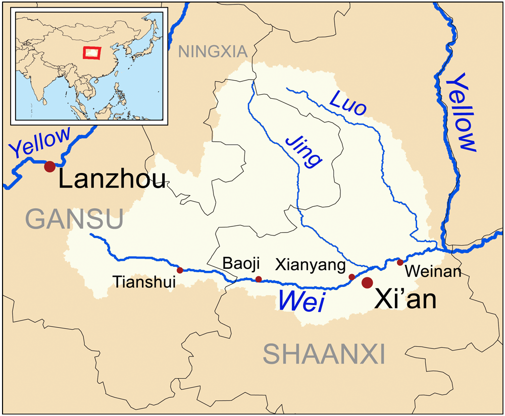
| | | | The thing that you cannot miss on the map even before enlarging is the magnificent Ming Wall around the Old City. Typically, it's a perfect rectangle--rectangles are typical for many older Chinese cities and their walls, since they so often were planned cities. Beijing's was, roughly speaking a rectangle with another one added to the south, but Xi'an's walls are four perfect lines. | | | | Browse on the map as you wish, but the only thing I need you to note for now is the location of our two historic and iconic friends. From the south gate look southwest for the Small Wild Goose Pagoda and from the gate look twice that distance southeast for the Great Wild Goose Pagoda. (I prefer the English translation "Great' as being the most dignified. Some sources prefer "Giant", which seems too fairy-tale-ish to me, and others, including the map, like "Big", which to me is too mundane, although it IS a good opposite to "Small".) | | | | We've said that Xi'an is the second oldest city in China, and we know it and its area have a lot of history. We've talked about it before, in 2013/22, called "Four Chinese Dynasties: Qin, Tang, Ming, Qing". Those were to me the most significant dynasties, and it's the first three that apply particularly to Xi'an and its area. We need to do just a quick recap of what we said, paraphrasing and summarizing the main points. | | | | The Qin Dynasty lasted only 15 years, from 221 to 206 BCE. Qin Shi Huang, the king of the State of Qin, unified the six other states under his rule and declared himself the first Emperor of China in 221 BCE. The Qin capital was Xianyang, a few kilometers upstream from Xi'an (no apostrophe in Xianyang, ao "xian" is one syllable here). This map of the Wei River basin shows the locations of both Xianyang and Xi'an across the Wei River (Map by Kmusser). Two accomplishments we should recap of the first Emperor is that he was responsible for the earliest form of what we call today the ● Great Wall of China and for the lavish, and as yet unexcavated mausoleum built to the northeast of what is today Xi'an. We know it today as the ● Mausoleum of the First Qin Emperor with its famous Terracotta Army. It is known that the mausoleum followed the plan of his capital, Xianyang. | | | | You can refer back to that earlier posting to review the details of the wackadoodle First Emperor, who falls somewhere between being the Adolf Hitler and the Josef Stalin of his day, who declared that all history started with him and that all earlier records should be destroyed. Anyone who didn't destroy his records would be buried alive. He was also responsible for numerous lives lost in the building of his Great Wall, many of which were buried in the Wall where they died. Some of his accomplishments may be important, but his reprehensible crackpot character then hangs in the balance. The worst of the destruction, book burnings, and burials happened during the last years of his life, between 213 and 210 BC. His death in 210 was followed by revolutions and war, and ironically, further destruction of historical materials. In 206, his capital of Xianyang was sacked and burned, including the imperial library and official archives. This destroyed the official copies that had been retained of the banned books and documents, as well as the Qin records that weren't banned, but approved, resulting in a huge cultural loss to China and to human knowledge in general. It was also the fall of the Qin Dynasty. Between 209 and 207 there were two ineffectual successors to the First Emperor, followed by the coming of the Han Dynasty in 206 BCE. | | | | Regarding our Xi'an visit, just keep in mind that the First Emperor was associated with Xianyang on the north side of the river, which was the Qin capital for over 140 years, and the mausoleum east of present-day Xi'an, but had nothing to do with Xi'an itself, which didn't exist yet. | | | | We mention the coming of the Han Dynasty (206 BCE-220 CE), which we haven't discussed. The only reason we mention it is because four years later, in 202, the leader of the Han Dynasty built a new city on the south side of the river, which was then named Chang'an. I'd had a lot of trouble figuring out conflicting information on Chang'an, and only now come to the realization that there were two different locations that bore that name, so this one, which was the Han capital, we should call the (Han) Chang'an. It was located 3 kilometers northwest of modern Xi'an, and was the political, economic, and cultural center of China, and, as we know, was also the eastern terminus of the Silk road. It was a large city with City Walls and palaces. However, uprisings and wars took their toll as well as at Xianyang, and the old site of Chang'an became an abandoned ruin. | | | | We now reach the main point. It was difficult for me to figure out about where the new Chang'an was built, and now I understand it was right where Xi'an is, only it was much larger. While Xianyang and Han Chang'an existed back-to-back, the new Chang'an was established at this second location over three centuries after the Han period, during the short lived Sui Dynasty (581-618 CE), and then continued and thrived throughout the Tang Dynasty (618-907 CE). We can therefore call this new location the (Tang) Chang'an. This should be the ruined ancient city that interests us most, since it's the basis of what later grew into Xi'an. Copy and paste this link into another window for our map of Tang Chang'an:
http://gossamerstrands.com/Hist100/100images/0636MC12.gif
| | | | The most frustrating thing about finally figuring out that this Chang'an, while much bigger than Xi'an, is at the same location as Xi'an, is that I haven't found a map that superimposes the two of them. But we'll be clever and figure it out with proof in a moment. Just accept this map of Tang Chang'an in the year 750 CE at face value for now. | | | | It's also a rectangle, but that shouldn't surprise us by now. The exterior walls were 5.5 m (18 ft) high and formed a rectangle of 8 by 10 km (5 by 6 mi), so the city was quite large. As in Beijing, the government buildings are to the north. The gold rectangle shows the Imperial City, which was the seat of the central government, and the adjoining purple rectangle was the Palace City, part of the royal household, which one map called the Forbidden City. The rest of the residential area within the walls was the Outer City. | | | | The area jutting out from the City Walls to the north was the complex of the imperial palace and actual royal residence of the Tang emperors, Daming Palace. Daming (Palace) translates as (Palace of) "Great Brilliance". [I consider the translation on the map of "Great Luminous Palace" to be inadequate. Perhaps better would be "Great Luminosity Palace", because it wasn't the palace that was being called great, it was the concept of brightness, brilliance, or luminosity. Not being a speaker of Chinese, I'll still go with my translation.] | | | | The city was laid out according to the principles of feng shui, as a chessboard, with east-west and north-south streets. This grid pattern, which included two large marketplaces, the West Market and the East Market, divided the enclosure into 108 wards, each of which was walled and gated. They were much larger than modern city blocks. The smallest ward had an area of 28 hectares (68 acres), or 0.28 sq km (0.12 sq mi), and the largest ward 94 hectares (233 acres), or 0.94 sq km (0.36 sq mi). The walls around each ward averaged 3 meters/yards in height, so we can't picture them exactly as modern city blocks. | | | | You'll recall that the main historic axis of Beijing, the Imperial Way, ran to the south of the government area, south being an auspicious direction. Look again at the map of Chang'an, where the government buildings face south. Visitors to the city, from around China and around the world, many via the Silk Road, entered Chang'an from the south, in the central gate called the Gate of Luminous Virtue. They then traveled up the broad central boulevard, the Street of the Vermilion Sparrow, to the Imperial City. | | | | As ever, Silk Road traders brought all kinds of products and ideas to Chang'an. Tea was first used by Buddhist monks as an aid to meditation (an interesting thought). It then became fashionable and was drunk by the wealthy. Chairs were introduced (I'm guessing there had otherwise been only stools and benches); they became very popular and were reserved for the upper classes. | | | | During its heyday, in about 750 CE as on the map, Tang Chang'an was one of the largest and most populous cities in the world, one reference saying it was the most populous. It was on a par with Baghdad and Constantinople. Around that year, Chinese records called Chang'an a "million people's city", although modern estimates estimate there were between 800,000 to a million within the City Walls. | | | | But as with Xianyang and Han Chang'an, Tang Chang'an was ruthlessly destroyed by war, uprisings, and sacking. The first attacks and occupations came in the mid-750s, shortly after the date of our map. Later it was occupied by the Tibetans and Uyghurs!! Warfare continued through the 800s, and in 904, buildings were demolished and the capital was moved to Lyouang. The emperor and residents also moved there, and Chang'an, after having been the apex of the Tang Dynasty, never recovered. | | | | From that time on, only a small area of the city continued to be occupied, a situation that lasted over four and a half centuries until the start of the Ming Dynasty (1368-1644 CE). In 1370, to protect what was by then a much smaller city, a new wall and moat were constructed, which remain to this day, and after a series of namings, the city is today Xi'an. | | | | That would seem to bring us up to date, but we still don't know just where the smaller Xi'an sits on the larger footprint of Chang'an. But two old friends will help us. For this we need to copy and paste this second map of Chang'an. It's a little dark, but gives us some great information:
http://www.sde.nus.edu.sg/changan/menu.jpg
| | | | Our two helpful friends are the Great Wild Goose Pagoda and the Small Wild Goose Pagoda. Find them on this map, and then compare their location on our Xi'an map. These two pagodas are the most spectacular remnants from Tang Chang'an. They will indicate to us that just about all of the huge Outer City of Chang'an is NOT part of today's Xi'an, and that the current Ming walls are approximately located where Chang'an's Imperial City was, with perhaps the lower half of the Palace City. The rectangles don't seem to coincide, and the area of the Ming walls is perhaps wider. But like all walled cities, there was surely nothing outside the walls but fields until modern times, when the modern Xi'an grew around the Old City. Thus, in addition to the Daming Palace to the north, Chang'an extended a bit to the east and west of the current walls, but considerably to the south. It's estimated that the land area of Chang'an was eight times the size of the Ming Xi'an (some say ten). A map like this with the two pagodas helps us to imagine Xi'an superimposed upon Chang'an. | | | | And this second Chang'an map gives us a lot more insight into that city. On the right, three wards are pointed out as to population. Of the two markets, it's pointed out that the East Market was not only the busier, but the claim is made that it could have been the busiest commercial center in the world at the time, given that Chang'an could have been the biggest city in the world. On the left, the main gate is pointed out, plus the main avenue, and the claim is made that the avenue was 155 m (509 ft) wide, or the equivalent of 45 highway lanes. Finally, at the top, two almost-surviving areas of Daming Palace are indicated, Hanyuan Hall and Linde Hall. Other than the two magnificent pagodas, these two Halls are apparently the only remains of note of Cheng'an. | | | | Which brings us back to our main Xi'an map. Look at the east end of the Ming Wall and then look north, and you'll see the modern park containing these two remnants of Daming Palace discovered in 1957. Apparently they have the site of Linde Hall, which had been used for banquets, performances, and religious rites, and the remains of Hanyuan Hall (Photo by Danielinblue), used for state ceremonies and receiving ambassadors. I did not visit the Daming Palace park, or even know of its existence at the time. This is the reconstructed Danfeng Gate of Daming Palace (Photo by Zhang zhicheng). | | | | While on the Xi'an map, look at two other things, both located in the inset map on the lower right. Note that the entire suburb in pink is called Chang'an. Judging again from the two pagodas, I'd say Chang'an only reached a little distance south into this area, but apparently gave the whole suburb its name. Then look across the Wei River to find that Xianyang still lives! I can't speak about ancient ruins here, but the whole lilac area is called Xianyang City. Not only that, but look at the name of the airport I flew home from. Actually, it's full name is Xi'an Xianyang International Airport—but it's located in Xianyang. | | | | A Language Blast from the Past We haven't talked about language for some time, and I've found something that's applicable. We learned a few basic Chinese characters (hanzi; in Japanese, kanji) in 2009/31 "Writing Chinese" and 2009/37 "More Kanji". We learned only some of the few that are pictograms or pictographs, in other words, that come close to offering a picture version of the word. If you enjoyed working with them, you might like to review them. In any case, I'm going to review a few right now from those two postings, which are applicable to what we're doing. | | | | | | | | This pictogrammic character represents a person. I see two legs and a head. It’s as close to a stick figure as you can reasonably expect. In Mandarin it's ren. | | | | | | | | It doesn’t get any easier than this—a person holding his arms wide out. Say da. | | | | | | | | Remember, Chinese writing doesn’t use circles, so you'll have to picture a square sun. Let’s interpret why there’s a bar across the center. Could it be the horizon? In Mandarin it’s read as ri. Since first learning this, we've noted on rail tickets that it's also used to mean "day/date". Of course it does. Day is when the sun shines. | | | | | | | | This one has a subtle logic. First, it’s based on the character for sun, so you know you’re going in the right direction thinking of something in the sky. Then you see that the left stroke has that charming curve, which is surely the division of light and dark on the half-moon. On tickets, we saw that it also means month ("moon+th"). It’s yue in Mandarin. Finally, we have a character that's a combination of two others: | | | | | | | | What exquisite logic. Combine both the sun and the moon, squeeze them together to fit better, and everything is bright. In Mandarin, it's ming. | | | | Practical Applications Now let's make some use of our knowledge to identify some items. | | | | ● If 雁, yan, means "wild goose", identify which one of the two Xi'an pagodas this is: 大雁 What's its full name in Chinese? | | | | | | It's the Great Wild Goose (Pagoda), in Chinese, the Dayan. The Small Wild Goose (Pagoda) is the 小雁, or Xiaoyan. The character 小, xiao, almost looks like it's lowered its arms to indicate smallness. |
| | | | ● If 街, or jie, means "street", how do you say 大街? What's a good one-word translation into English? | | | | | | It would be Dajie, literally "big street", so in one word, it would be a boulevard or avenue; in two words, a main street. |
| | | | ● If 朝, or chao, means "dynasty", identify this dynasty: 明朝 How do you say it in Chinese? What does it mean literally? | | | | | | The sun-and-moon character means "bright", but is pronounced ming, so this is the Ming Dynasty, in Chinese Ming Chao. While we do not translate names, we could call it the Bright Dynasty ("Dynasty of Brightness"), but I'm sure hyperbole would set in to both the Chinese and Western ear, so through that filter one would perceive, Splendid Dynasty, or Magnificent, Grand, Imposing . . . or just Bright. |
| | | | ● An alternate way of saying Ming Dynasty is to call it the Empire of the 大明, perhaps a reference to the Emperor himself. What's that in English? What would that phrase sound like in Chinese? Where have you heard it earlier in this posting? | | | | | | It's called the Empire of the Great Ming, and I wouldn't translate that any further. In Chinese, Great Ming is Daming. And now you know the meaning of the name of the palace to the north of Chang'an! |
| | | | [I cannot explain definitively why a Tang Dynasty palace would have the same name as the Ming Dynasty that didn't exist until four and a half centuries later. I can only assume that this situation is a coincidence based on the Chinese-language penchant for flowery names. Actually, the palace was originally the Yong'an, was renamed Daming in 635, Penglai in 662, and Hanyuan (today the name of one of its Halls) or Yuan in 670, becoming Daming again in 701. This repeated vacillation in naming could indicate that they were only looking for a spectacular, flowery name, and Daming / Great Brightness finally fit the bill. Then, the later dynasty called itself the Ming Dynasty / Dynasty of Brightness or the Empire of the Daming / Great Ming / Great Brightness. This would seem to be the flowery coincidence I suspect.] | | | | Xi'an Visit It was still the end of Day 7, my second day on the train out of Lhasa, when we paralleled the Silk Road and afterward arrived in Xi'an (Photo by 颐园新居) in the early evening, sometime after 8 PM. (This and the next two pictures show daylight, but it was dark at the end of September, so picture it that way.) You'll recognize the Tibet train in Xi'an Station by its green-and-yellow livery. While there is now a new Xi'an Bei Station in the northern outskirts, it serves most of the high-speed trains at the moment, while all conventional trains still stop at the main Xi'an Station in town (Photo by David Castor), including the Tibet train. I include this picture, not because there's anything remarkable about the station building, or the large plaza in front of it—except this. We're looking north at the station. Let's do an about-face in the plaza and see what we see (Photo by Vmenkov). We are directly adjacent to Xi'an's historic City Wall, visible in the evening darkness right in front of us across the plaza. What a thrill to see something so famous immediately upon arrival! Look at our main map and find the Xi'an Railway Station right at the northeast corner of the City Wall. | | | | It was the end of my being totally on my own ever since taking the taxi to the Lhasa Station, since I was met inside the Xi'an Station by my guide, who walked me across the plaza to our waiting car and driver. He was on the young side of middle age, and said I could call him Lee, or otherwise Mr Li, which explained what he based his Western name, Lee, on. While I rarely called him by name, I did stick with Mr Li. | | | | As the two of us crossed the plaza, it was a joy to see the evening illumination all along the City Wall. We then drove to the Shangri-La Golden Flower Hotel, which, I had calculated before leaving home, lay in an area of the newer part of town about ten minutes east of the City Wall. Check our map—the hotel's on it. | | | | Which brings us to another bothersome aspect of having someone else put a trip together (although to my specifications on the add-on). When I was told before leaving home about this hotel, I wrote back and pointed out another hotel, recommended by Frommer, right in the old city, the Bell Tower Hotel to the southwest of the Bell Tower and facing it with beautiful views! This hotel is also on our map. Frommer said it was a nice hotel, with English spoken at the front desk. This was one time I decided to assert myself, and wrote back mentioning this alternative. Word then went from the travel agent to the agent in China—I really hate two levels of red tape—that "only Chinese went to that hotel", as though that made it defective. But I gave up, and decided not to "fight City Hall", and accepted their choice. | | | | Only now do I understand that Shangri-La is the name of a chain, and the name of this hotel is just the Golden Flower. It was a very nice, tall glass-and-steel building, nice lobby, nice room, blah blah, opening onto its own small park before it. Otherwise, it was in a totally nondescript neighborhood, totally inconvenient for walking around, unlike being in the center of the Old City. But my reason for yielding was that I knew I had planned only one full day and two nights in Xi'an. It was already late the arrival evening, and the next day it would be too much to try to do more in the evening after a long day, so I had given in. Mr Li got me registered, and I settled in for my two nights in Xi'an surrounding one spectacular day. | | | | From Frommer's book I had picked four things I was deeply interested in and wanted to do in Xi'an, and they all fell into place beautifully on Day 8 of my extension. I'll just use single code words now, as we all go together to see them: Terracotta, Pagoda, Walls, Mosque. Only now as I review this, do I realize that, purely by chance, I saw the four sights in chronological order, from Qin, to Tang, to two from the Ming! | | | | Mausoleum of Qin Shi Huang & Terracotta Army Half that title is a lie, since you don't get to see the buried Mausoleum—no one alive today has--just the Army, but it all will make sense only if we talk about both. Mr Li and the driver picked me up that morning, and we drove on an expressway about 20 minutes northeast, then turned right for a short distance and entered the museum compound of the Terracotta Army and parked. Mr Li's tour was compete and faultless, and he may possibly have mentioned the Mausoleum in passing. But I didn't understand its importance, nor even which direction it was in from where we were standing while visiting the Army, so obviously, I didn't see any trace of it. I suppose some of my pre-trip research was lacking and that I just didn't understand the full connection between the two. No matter. There's little to see anyway compared with the Army, and current post-trip research has filled in the blanks. While the Army is world famous, I'm sure most people consider it a destination of its own, including me at the time, and don't realize that it's part of the necropolis surrounding the Mausoleum, all of which is just the "tip of the iceberg". The "iceberg", hidden under the surface, is the Mausoleum itself. So now let's start over and consider the entire package of this first destination of the day. | | | | It was Mr Li's suggestion that we start the day with the Army, and I fully agreed, since Frommer had already warned me, explaining that the site could get busy later in the day and that a mid-morning arrival is suggested. It worked, and the site was not crowded at all. Keep in mind that, while world tourism associates the Terracotta Army site with Xi'an, which would make it Ming, it's actually a Xianyang site, and totally Qin, about 1.5 millennia earlier than the Ming period. | | | | Look again at our Xi'an map, and at the inset in the lower right. I hadn't seen this map yet when I was there and didn't know the placement of these sites, so now we all can follow our car on the expressway for 40 km (25 mi) northeast. We now know that the car first passed the site of the Qin Shi Huang Mausoleum before turning right to the east of the Mausoleum to the Museum of the Terracotta Army. This map also allows us to see that the distance to Xianyang, with which the Mausoleum and its Army are associated, is not much further than to Xi'an, with which it really is not associated. | | | | Hidden underground as it remains, the Qin Shi Huang Mausoleum is a UNESCO World Heritage Site, including the necropolis, which includes the Terracotta Army. As an indication of that, I have a note to the effect that the name on the ticket to see the Army that Mr Li got for me said nothing about Terracotta Army, but called it instead: EMPEROR QINSHIHUANG'S MAUSOLEUM SITE MUSEUM. | | | | The Mausoleum was built over a period of 38 years, from 246 to 208 BCE. A funeral mound, or tumulus, 76 m (249 ft) high was built above it. Tumuli exist in cultures all around the world, and I can refer back to the tumulus/burial mound we saw in Nanjing which included the mausoleum of the First Ming Emperor. The current one is not only the Mausoleum of the first Qin Emperor, 1.5 millennia earlier, this wackadoodle was the First Emperor of China, ever. | | | | This is a decent plan of the Mausoleum and its surrounding necropolis, including the Terracotta Army. Copy and paste this link into another window:
http://image.chinatour360.com/map/xian-terracotta-warriors.jpg
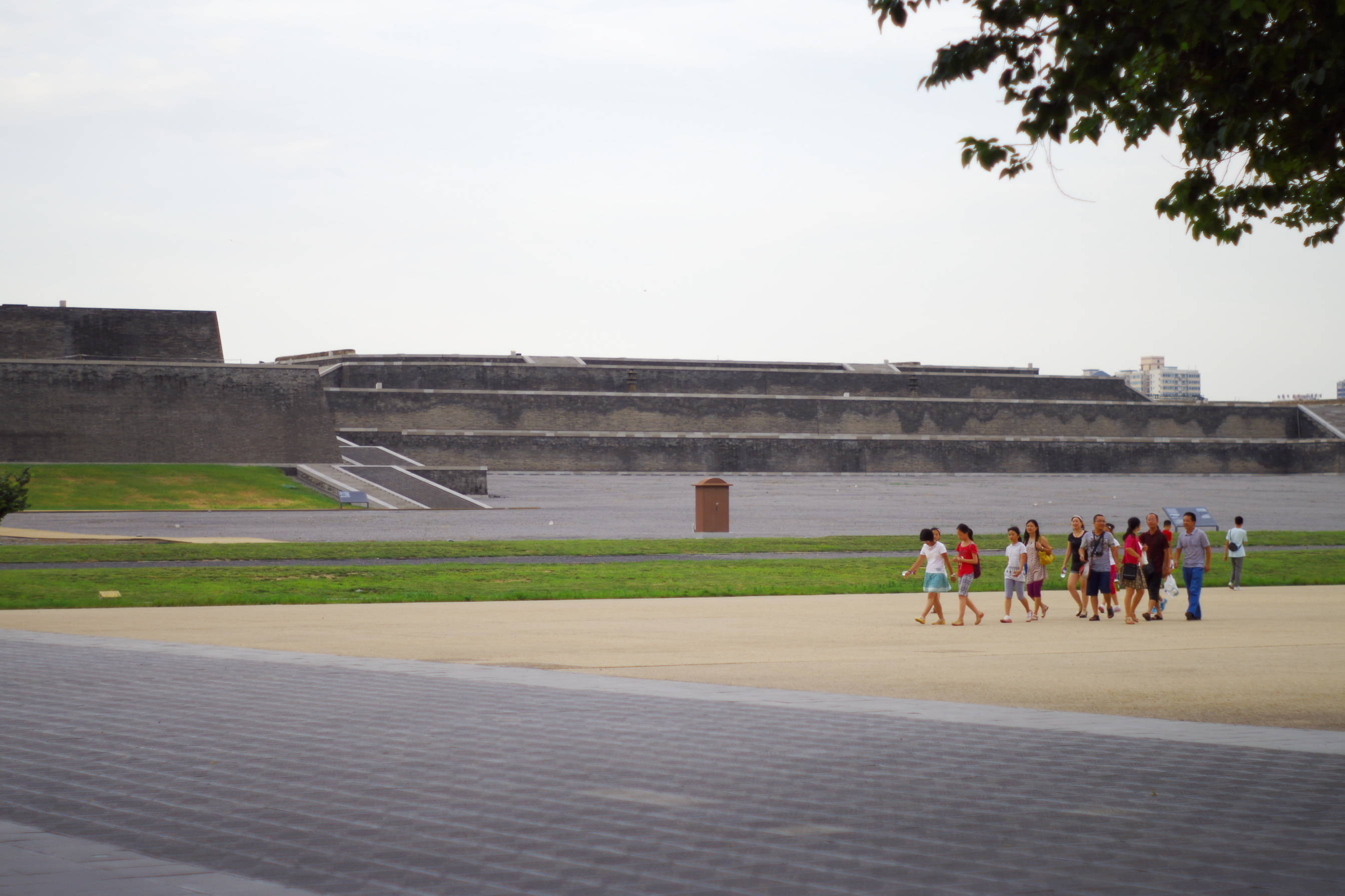
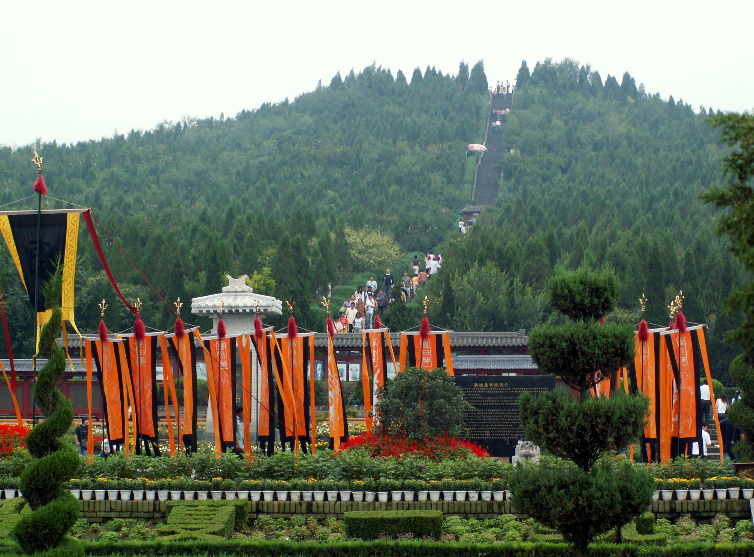
| | | | The burial site is laid out as a microcosm of the Emperor's capital, Xianyang, divided into inner and outer cities. Only the outer city wall is named in this plan, while the inner city wall is within it. The total length of the outer city wall is 6.3 km (3.9 mi). The tomb itself, under its mound, shown here in red, is located in the inner city and faces east. It's estimated that some 700,000 workers were forced to work on the complex over the years of its construction, and it's believed that this burial complex is the largest in the world. Furthermore, since a fourth pit found in the area of the Army was empty, it's been suggested that the complex was probably never quite completed. | | | | The entire area around the tomb is the necropolis, and that is where archaeological explorations are currently being concentrated. This includes work at the Terracotta Army, 1.5 km (0.93 mi) to the east, as seen on the map, which has yet to be completely excavated. Why is the Army located to the east? Why does the tomb also face east? After all, the Emperor's nearby capital, Xianyang, lies to the west. | | | | The answer lies in the fact that the Qin Emperor's conquered states all lay to the east. While he wanted his tomb to face his lands, he also wanted his Terracotta Army to "protect" him from potential attacks from them. How unpopular was this guy? | | | | Artifacts were found all around the necropolis, including bronze chariots and horses (on the map). Inside the inner wall were terracotta figures of courtiers and officials. Between the walls were pits of entertainers such as acrobats and strongmen. To the north of the outer wall was a park with bronze birds, and musicians. There were also stables (on the map) with horses and grooms. On the map are the mass graveyards for the workers forced to build the complex. | | | | As for the tomb mound itself, it still remains largely unexcavated. However, the underground palace has been located at the center of the mound. By means of various scientific methods, it's been determined that the palace has a brick perimeter wall that's 4 m (13 ft) high and that runs 460 m (1,509 ft) north-south and 390 m (1,280 ft) east-west. | | | | The actual tomb chamber is about 15 m (49 ft) high and runs 80 m (262 ft) east-west and 50 m (164 ft) north-south. But the unanswered question remains about how deep the palace lies. Scholars disagree, with estimates ranging between 20-50 m (66-164 ft). | | | | It's been four decades since the site was discovered in 1974, and still less than 1% of the site has been excavated. There was some fear of damage to the palace, to artifacts, and to the body itself, but others argue that current technology is not up to dealing with the large scale of the underground palace yet. A mistake made with excavating the Army was that scientists were unable to preserve the paint on the statues, much of which was rapidly lost when they were exposed to the air. | | | | But the most bizarre concern comes from mercury, high levels of which were found in contaminated soil samples, constituting a safety hazard. It's believed that, in the attempt to recreate the surface world underground, mercury was used to simulate local rivers on the floor of the tomb. Not only is the ground poisoned, but some believe that if the underground palace were excavated, the mercury would vaporize, be inhaled, and be a mercury-poisoning hazard for the archaeologists and workers and would also be a general public health menace. | | | | This is the burial mound (Photo by wit), which I did not see. I'm not totally sure, but I have reason to believe that we're looking at its western side, so that I would have been behind it in this view. As I said, I never saw its eastern side either, which would have been closer to me, but then there were a lot of hills in the area, so I can't be sure. Click to better see the people climbing the steps. Consider the effort needed to build it. Consider the effort needed to excavate it. | | | | Let's now return to what actually happened on the trip as we arrive by car to see the Terracotta Army. Copy and paste this link in another window to see the layout of the very attractive, park-like Terracotta Army Museum campus, east of the Mausoleum mound:
http://images.chinahighlights.com/city/xian/map-of-terra-cotta-warriors.jpg
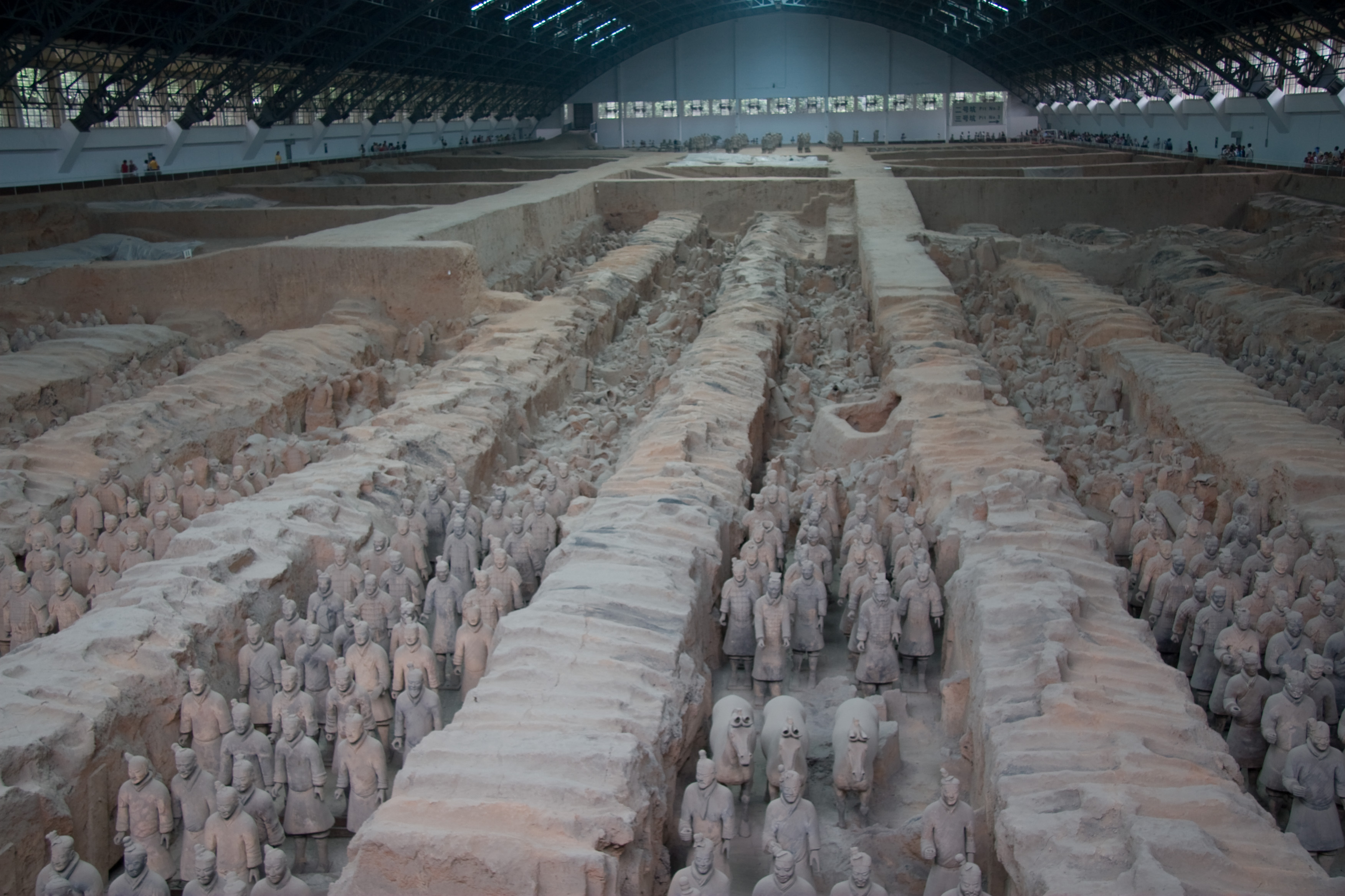
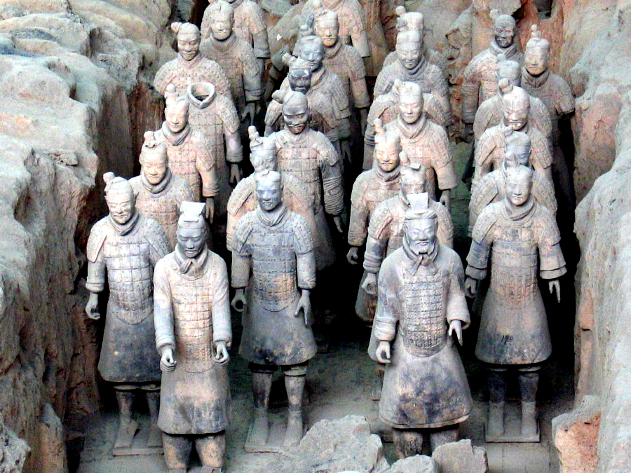
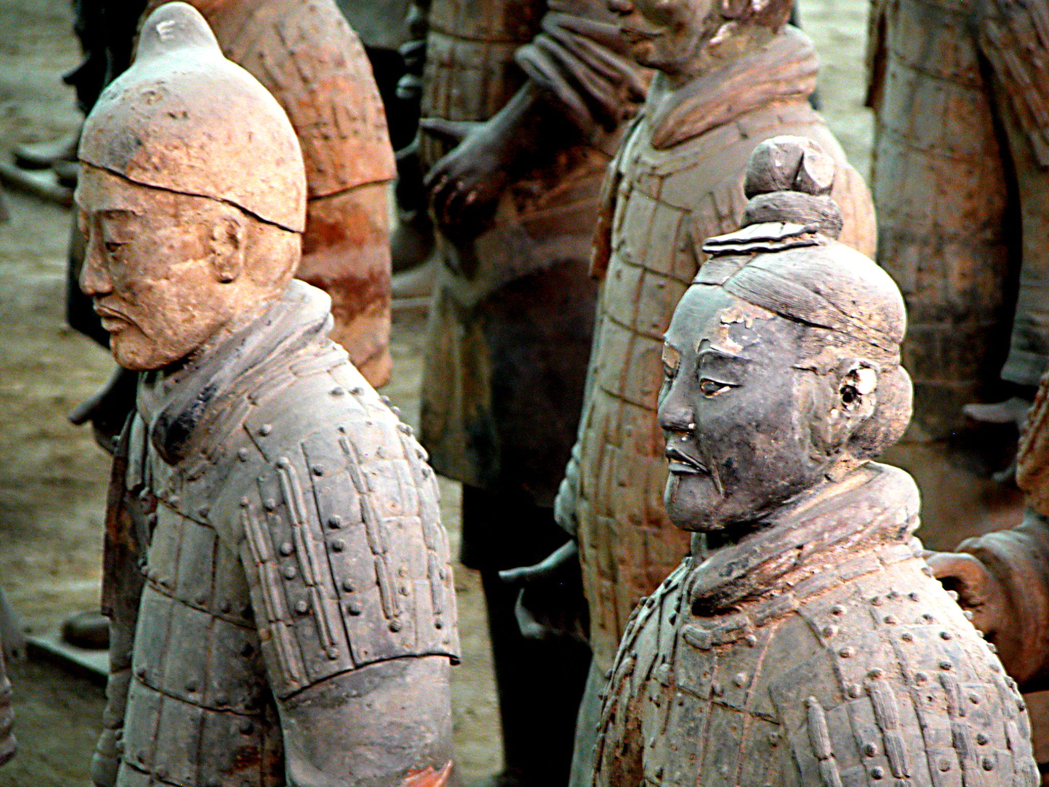
| | | | "Terracotta Army" is one of the common English versions of the name. This campus map says "Terracotta Warriors and Horses", since, besides the infantrymen, charioteers, cavalrymen, and archers, some archers standing, others down on one knee, about 5-6% of the statues are of horses. Another common English term is the Terracotta Warriors, but I find that word stilted and leaves out the horses. The Xi'an map says Terracotta Legion. It seems to me that the word "Army" is the most inclusive and summarizes best what it's all about, so it's the word I'll continue to use. | | | | Look at the layout of the campus beyond the entry plaza. You see Pit One, by FAR the largest and most significant, also Pit Two and Pit Three. As mentioned earlier, there is a Pit Four somewhere, but it was found empty, leading to speculation that the entire Mausoleum complex, under construction during the Emperor's lifetime, was never completed once he died. We visited all three, and at the end, also the Exhibition Hall of Bronze Chariots and Horses (Photo by Tomasz Sienicki). They were interesting enough, but one comes here to see terracotta. (On the map, the chariots are called gharries.) | | | | As to that word, in Italian, terra cotta means "baked earth" (literally "cooked earth"), and "terracotta" usually, but not always, as one word, has come to mean in many languages a type of porous, clay-based earthenware. The contact most people might have had with terracotta is in the common terracotta flower pot (Photo by Attilio Mileto). Click to inspect its porosity. The Italian root cott- also appears in other words of Italian origin: ricotta (cheese), literally "recooked", and biscotti, literally "twice cooked/baked" cookies/biscuits. (And "biscuits" is related to "biscotti".) | | | | I must say, I find the use of the word "pit" in English at this museum to be misleading and disconcerting. Right until I arrived, I had imagined that visitors had to go down into some sort of coal mine affair to view the sculptures underground, so I was happily surprised to see that all the buildings on the campus, including the main ones described as "pits", were quite museum-like, including the principal one, Pit One (no attribution), here seen from the outside. Note that window wall in the front of Pit One. Here's that window wall from the inside (Photo by kevinmcgill). You can see here that, with walkways on all four sides, one is well above the several pits below (click), which are about 7 m (23 ft) deep. Adjoining are some areas with glass display cases containing statues of particular note. | | | | Looking inward from the entrance, one sees that this one huge Pit One building (Photo by Maros) reminds one of an airplane hangar, and is about that size. Here's a diagonal view over to one side (Photo by © BrokenSphere / Wikimedia Commons). This is about as busy as the place was, in other words, not crowded at all—but it was mid-morning and, in September, not high season anymore. I suspect that in season, that large plaza in front of the buildings might fill up with lines of waiting visitors by afternoon. | | | | The Army sculptures are replicas of what the Imperial Guard would have looked like during the Emperor's lifetime, so are significant on an artistic, historic, and military level. They are a form of funerary art that was buried with the emperor in 210-209 BCE with the intention of being a garrison to "protect" him in his afterlife. It has been estimated that the three pits containing the Army include over 8,000 soldiers, 150 cavalry horses, and 130 chariots with 520 horses. It is also believed that these have yet to be completely excavated, and that the majority of the statues are still buried in the pits. | | | | Pit One (Photo by Maros)--let's look at this same picture again to concentrate on the figures--contains some 6,000 soldiers out of the 8,000 that are believed to exist, mostly infantry with some horses, some of which can be spotted in the foreground. It's 230 m (755 ft) long and 62 m (203 ft) wide. There are four columns of soldiers (Photo by Ingo.staudacher) in each of eleven corridors, each corridor over three meters/yards wide, and paved with bricks. Pairs of horses (Photo by Maros) can be seen in two corridors here. Click to find the tailless pair. | | | | There were originally posts supporting beams and a wooden ceiling on each corridor. It's believed that these corridors would have resembled palace hallways, and this same design was also used in the tombs of the nobility. The ceilings would have been covered with reed mats and layers of clay to waterproof them. On top of that would have been mounds of soil, so they would have protruded some 2-3 meters/yards above ground level. I must say, they must have been quite obvious at the time and difficult to protect from looters early on. It's estimated that many of these were vandalized soon after the Emperor's death. | | | | Frankly, the site is so big that just what is located where swirls easily in one's mind, but available data reminds me that Pit Two has some 1,400 soldiers that are less intact than in Pit One, requiring additional painstaking restoration (Photo by Maros) well into the future, but with greater diversity of posture. In addition to infantrymen, there's also cavalry and war chariots. Pit Three is much smaller (check map) and is thought to be the command post, containing high-ranking officers and a war chariot. | | | | All these statues was created in workshops by local craftsmen and government workers. They were not built in one piece each but were put together into a finished piece from separately made parts--torsos were created separately from arms and legs, and from the heads, which were the pièces de résistance. The legs were made in the same way terracotta drainage pipes were made at the time. While most of the hands are identical, for the heads, eight separate molds were used, then distinctive facial features were added with clay after assembly, so that each figure has a unique face, an illustration of a high level of artistry and craftsmanship. All in all, it was an assembly line production, with each piece made and fired separately, then assembled. No single complete figure was ever fired in one piece by itself. | | | | When ready, the figures were placed in the pits in military formation, grouped by rank and duty. While they are all life-sized, one interesting variation in the figures is that they vary in height, but not in a natural way. Their height varies with their roles, so that the generals were the tallest. Uniforms and hairstyles also varied according to rank. As can be seen by the position of hands and arms, most figures originally held real weapons, such as spears, swords, or crossbows. The map shows there is a separate exhibit of these, which I did not see, but I don't mind. It can also be assumed that many weapons were lost due to early looting, or may have rotted away. | | | | Click to inspect the variety in these freestanding figures (Photo by Maros), plus in this closer detail (Photo by airunp), especially the hands that had clasped actual weapons, and in this headshot (Photo by Peter Morgan), where you can inspect the variety of facial detail. You can also see repaired pieces that had been painstakingly reassembled like a jigsaw puzzle (Photo by Maros), some still headless (click). Speaking of headless pieces (Photo by Maros), they are of particular interest, since they show how cleverly the heads fit into the collars of the tunics, disguising any seam. | | | | The figures appear very realistic, not only because of the varying facial features and real weapons, but because they were also originally painted in bright lacquer colors, including red, blue, pink, green, white, lilac, black, and brown, but these colors have either flaked off or faded, a process speeded up with the statues being exposed to fresh air once again. | | | | We said that special pieces were in glass cases off to the side, such as this cavalryman and horse (no attribution). I particularly remember spending time looking at the glass case with the kneeling archer (Photo by Maros). He no longer has his weapon, and you can spot a seam on his shin, but other seams are very well hidden. This archer is also interesting in a view from the back (Photo by Immanuel Giel), where you can click to see that he's one of the few statues that have paint remaining, in this case, red stripes on his tunic. And take a close look at the detail of his shoe tread (no attribution), as well as another view of the red stripes.
| | | | As we were leaving, that subject of photographs came up that I already discussed quite a bit earlier. Mr Li walked me up to the front of Pit One near the entrance where there were several photographers, and said it was time to take a picture, at which point I told him how I dislike touristy pictures of famous sights with a grinning showoff in front—I don't even take pictures of the sights. I knew a picture had been mentioned on the unitemized bill I'd paid for the supplement, but just assumed that the opportunity would be offered for a picture, to be paid for on the spot, which I'd skip. Mr Li seemed shocked, and told me "But it's paid for!" Furious as I was—and I did write the travel agent afterwards, I didn't let it spoil what was otherwise perhaps the best day of the trip. | | | | The other photography matter is a curiosity, something I found interesting, but would never want for myself either. There was a small, very upscale photography studio there right in the Pit One building that specialized in photoshopping your face onto an image of a statue. It was quite masterfully done, your face even took on the beige of the terracotta, and the patching was seamless. They had pictures of several celebrities as Terracotta Warriors, and I particularly remember Bill Clinton as one. An interesting curiosity, but certainly not for me. | | | | Now at the end, the only thing we haven't discussed is how the Army was rediscovered. For centuries, people would occasionally find in the local fields pieces of terracotta, perhaps from statues, or from roofing tiles, also pieces of bricks and masonry. But on 29 March 1974, some local farmers—Mr Li specified there were four—were digging a well in a field and came upon the Terracotta Army. What a spectacular find. My notes say I saw the site of the well, and I have absolutely no memory of it. Perhaps it was a plaque, perhaps a small monument, I just can't picture it. But Mr Li went on to explain that, of the four men, one of them has died, and one of them shows up regularly at the Museum bookstore to do signings, and I thought that was just charming. What a nice way to spend his retirement. | | | | But for me, that story just the other day had a pleasant little extra twist, one that shows the helpfulness of multilingualism when doing research. I'd pretty much exhausted the pictures available online about the Army and had chosen the best of the best for this posting. I then went back to the Wikipedia article on the Army and decided to flip through other language versions, looking for a certain word as it varied from language to language. When I got to the Italian version, it had only three pictures, and one was of an elderly man with a pen in his hand that didn't appear anywhere else. It meant nothing to me and I was about to move on when I read the caption: Lo scopritore dell'esercito di terracotta. Well, the end of the phrase was obvious, but I didn't fully catch at first that long word up front—and then came the epiphany: the prefix s- always corresponds to "dis-"; coprire is "to cover"; -tore corresponds to "-er". He was the discoverer! So this little bit of serendipity, plus finally recognizing the Italian caption, led me to now be able to close this section with a picture of the scopritore (Photo by Lingtft opera propria) of the Terracotta Army—although of course there were actually four scopritori--doing signings in the museum gift shop. | | | |
| |
|
|
|

