|
Reflections 2014
Series 7
June 14
China XV: Beijing II - Great Wall of China
| | Beijing Redux The first full day in Beijing had been occupied with Tien'anmen Square, the Forbidden City, the China Railway Museum, and Wang Fu Jing. On the morning of the second day, Day 11, we were told that, although we were scheduled to start with the Great Wall, Wendy had found out that that morning it was socked in with fog and mist, so we'd flip-flop our plans and leave the Great Wall for the afternoon, which ended up working out just fine. Instead, we'd start that morning by going to see hutongs in the neighborhood I'd read about in Frommer where they still are to be found, and might—possibly—be retained. | | | | We need to have available in another window that same map of central Beijing we've used in the past, so copy and paste this link:
http://www.johomaps.com/as/china/beijing/beijingcheng.html
| | | | Again, the former walled Inner City is now divided in two, and the hotel was in the Dong Cheng (East City) near the Dengshikou Metro station, and we were going to the Xi Cheng (West City) to the area of former Imperial lakes and gardens. All six lakes, which form a chain, were manmade, but well in the past, dating back to the 10C. The three larger lakes, including Beihai with its White Pagoda, are immediately adjacent to the Forbidden City (the palace), and we'll get to that in a couple of days. Look to the three smaller lakes above that leading to the Desheng Men, the preserved northern gate. Look at the area between the Bell Tower and Drum Tower, which also have nice icons on this map. The preserved hutong area is in the V-shaped area between all these. | | | | In this modern map, all these places flow together one to another, as if they were all meant to be together, but now let's look again at how they were placed originally on our old map of Beijing city walls (Map by kallgan). It's a whole different picture as to what is where. The three large lower lakes and gardens are all within the Imperial City, the buffer zone for the palace. Our three smaller lakes are now merely in the Inner City, but not in the Imperial City within it, as are the Bell Tower and Drum Tower, which, by the way, are located on the same meridian axis that runs through the palace and well south of it. | | | | Shichahai Now, just as I never got to see the Denshan Men illustrated in the previous posting, neither did I get to these three lakes that Frommer strongly suggested one visit. But I now believe that the preserved hutongs that we did visit were right in their neighborhood—we were plopped there, so typically, with no indication of just where we were, merely that we were to visit the hutongs. Perhaps some people are not bothered by that, but I am, as I want to know where I am. Anyway, these smaller lakes are referred to as the Shichahai, the back lakes (Photo by FANG Chen), and Frommer says that ". . . this area, with it sublime public lakes and well-preserved hutong, is where the last fading ghosts of Old (pre-1949) Beijing reside." | | | | Hoping that I'd see the Shichahai themselves as well as their hutong neighborhood, I'd checked out in advance what the three lakes were called. Here's another map link to copy and paste in another window (click):
http://www.travelchinaguide.com/images/map/beijing/shichahai.jpg
| | | | You may recall that hai is "sea" as in the derivation of "Shanghai" as lying on the Dong Hai, or East (China) Sea. Apparently, similar to German, where See means both "sea" and "lake", hai can designate both as well. Start with the furthest lake on the left, Xi Hai, and we can see that that's West Lake. Skip the middle, larger one and move to the other small one, Qian Hai. You can see how this connects to the Beihai across the road and formerly, also across the wall of the Imperial City. We point out again the common, utilitarian name of one of the gates, Qian Men as meaning "Front Gate", so Qian Hai is "Front Lake". And sure enough, the long middle lake, Hou Hai, has to be "Back Lake" (it is, I checked). Now, while I never saw any of these lakes, the area we were in was definitely that V shaped wedge between Hou Hai and the Bell and Drum towers. Unlike the situation I found near my hotel, here, where it says Hutong, you can believe it. | | | | Another thing I was interested in but did not get to see in the Shichahai neighborhood is the Prince Gong Mansion or Gong Wang Fu (you'll remember that the street and neighborhood named Wang Fu Jing meant Princely Mansion Well). It dates from 1777 and consists of large mansions in the typical siheyuan courtyard layout, as well as gardens. It's supposed to be one of the most ornate and extravagant residence compounds in Beijing, and has recently been renovated, restored, and opened as a museum displaying the life of nobility in the Qing Dynasty. But again, I wasn't on my own, and there wouldn't have been time in the present schedule. On our map, you'll find the Gong Wang Fu south of the Hou Hai. | | | | Hutongs & Siheyuans In Shanghai we discussed (2014/4) the traditional Shanghai house, the shikumen, similar to a town house, and how the arranging of these buildings next to each other form side alleys or lanes called longtang, which developed into local "alley communities". The corresponding dwelling in Beijing is the siheyuan, whose arrangement form lanes called hutong. But there the similarity ends, since the buildings and lanes are not the same—other than the fact that they both encourage local street life, are small, and endangered. | | | | You'll recall that, just before the Ming and Qing Dynasties came the Yuan Dynasty under Kublai Khan out of Mongolia. Both the siheyuans and hutongs are of Mongolian heritage from this period, not much of a surprise, since North China is adjacent to Mongolia. | | | | A siheyuan is a cluster of small houses all facing inward and sharing a common courtyard, or garden. The courtyard has only one gate leading directly to it from the street, for purposes of seclusion. This allows the siheyuan to maintain a fortress mentality, protecting its bit of nature and privacy from the outside world. The name at first seemed complex to me, but, as we've found with most Chinese words, separation of the elements is helpful to understanding. We remember from Shanghai that the Yu Yuan is the Yu Garden, so we understand the last element. I now find out that the first means "four" and the second implies an enclosure, so let's say "side", so we now see that a Si He Yuan is a Four-Sided Courtyard/Garden. Couldn't be simpler. | | | | Historically, the siheyuan layout was quite universally used for residences, palaces, temples, monasteries, small businesses, and government offices. This model of a siheyuan (no attribution given) illustrates the layout quite well. Confirm the following on this model. Nearly all had their buildings and gates facing south for better lighting—and probably better feng shui. This allowed the building on the north, facing south, to be considered the main house. The ones on the east and west sides were called side houses, and were used by younger extended family members and other relatives; these three principal buildings are connected by covered passageways to protect from the sun and provide a good location to view the courtyard. The building on the south side facing north is simply called the opposite house, and served as a common area, or was used by servants. Behind the north building is often a separate backside building, which was the only place that could have a second story. | | | | The single entrance gate to the courtyard is usually in the southeast corner. The entrance is further shielded by a spirit screen (spirit wall, screen wall), meant for privacy but also, for the superstitious, to protect against evil spirits. It's most usually outside the gate, but can be inside, or even in both places. The ones outside often became status symbols by being richly decorated, such as with good-luck symbols. The Nine-Dragon Walls we've been discussing are extreme examples of upscale spirit screens. How do spirit screens "protect" from evil spirits? Think back to the Nine Zigzag bridge in Shanghai's Yu Garden (2014/5), then check in the next paragraph. | | | | The belief is that evil spirits aren't clever enough to move around corners, and that zigzags, bends, and corners will confuse and disperse them. As the bridge keeps them out of the Yu Garden, a spirit screen blocks them from entering the residence via the shielded gate, as the spirits will not be clever enough to maneuver around it. While spirit screens started out as a privilege of the nobility, they eventually spread over time to anyone who can afford one. It's the same story as with the Guardian Lions, which, by the way, can also appear with a spirit screen. | | | | Which brings us to the modern world. In the old days, a siheyuan would serve as a mansion for the wealthy, occupied by a single large, and usually extended, family. Today, many, if not most, that remain are subdivided among a number of families, and serve more of a housing complex, as seen by these siheyuan entrances (Photo by Pascal3012). They often lack modern facilities, which is one reason the government wants to get rid of them. This might be a typical siheyuan courtyard today (Photo by Pascal3012). On the other hand, just as with happens to larger older homes everywhere, some grand old siheyuans are taken over, refurbished and restored, and used as hotels, as can be seen in this upscale courtyard (Photo by Willem vdh). | | | | So what is a hutong? Rows of siheyuans engender small lanes or alleys between them, and these are the hutongs. The word is traceable back to the Yuan Dynasty, and is, not surprisingly, of Mongolian origin. Since each of these lanes had its own well, "hutong" actually means "[water] well". This is a residential hutong (Photo by Geoff McKim) and this is a commercial hutong (Photo by Alexanderpf). Since most siheyuans face south, there's a tendency for most hutongs to run east-west in front of them, and these are then often connected north-south between sihuyuans by even narrower alleyways (no attribution given) for convenient passage. It is essential that one understand that these lanes all developed on a human scale, not a vehicular scale. Cars can come through, but usually have to weave around pedestrians. It's like being in a small village, or local city neighborhood, not in a big city with grand boulevards with cars prevailing over people. People win out in a hutong neighborhood. | | | | Frommer points out that old Beijing maps show the city to be a huge, intricate maze composed almost entirely of hutongs. But they're disappearing, as block upon block in Beijing is replaced by highrises. Former hutong residents are allowed to live in replacement highrises, but usually complain at the loss of street life and community feeling. I'll remind of my consternation in the Wangfujing neighborhood around my hotel, where wide streets retained old hutong names, which I consider a real slap in the face. And does one come to China to see a Ferrari showroom and Godiva chocolate shop or the realities of neighborhood life? Fortunately, some hutong neighborhoods have been designated as protected, in an attempt to preserve this bit of cultural history. | | | | Now that we know what we're talking about, go back to the map of the Shichahai neighborhood we're holding on the side. Since I didn't plan the visit myself, I can't be perfectly sure of where we were, or which hutongs we visited. But I'm sure we were in the V-shaped wedge between the Hou Hai (which we did NOT see) and the Bell Tower, and I know for a fact that we actually stopped in the Bell Tower at the end of the neighborhood visit. | | | | We had a pedicab tour of this hutong neighborhood, including a home visit, which was really less hokey than it sounds. The only other time I was in a pedicab (or cycle rickshaw) was in Malaysia, on the Eastern & Oriental Express trip, when we stopped in Penang for a visit (2010/16). While the old rickshaws were pulled by a person on foot, something that is today considered too servile, they are now rare, having been replaced by pedicabs (Photo by d. FUKA), such as this one in Beijing. These are also called cycle rickshaws, since they are really not very different from a large tricycle, where the driver sits up front on a bicycle seat and two passengers sit in a fancied-up back seat, usually under a decorative canopy. It's been estimated that by the late 1980s there were about four million pedicabs in the world. | | | | There was a line of pedicabs all set up for us when we got off the bus. Since there were about two dozen of us, there must have been about a dozen pedicabs—quite a procession. I, with one of the other solo travelers in our group, happened to get into the first one, so we and our driver led the way. It was so small-townish, and very enjoyable, as we rode for 10-15 minutes through the neighborhood. | | | | We stopped at a small, working-class dwelling for what was advertised as a home visit. It was the house of an older woman, and her niece was there to help out with us visitors. There were enough stackable low stools for us all to sit down, and she served tea in little cups. She demonstrated her craft-making, and it was a pleasant quarter-hour. As I recall, either Wendy or her niece translated her remarks. The house was long and narrow. Up front was the entrance hallway sharing the house's width with a long narrow kitchen. Then came the living room, and the back was her bedroom. It would count as a studio apartment anywhere, except I don't think there was a bathroom (see above "lack of facilities"). We had noticed there were public toilet facilities in many streets (which we'd been using), and presumably that's what residents used as well. Afterward, we rode a little more by pedicab to the Bell Tower for a separate visit there. | | | | The best YouTube video I can find is unfortunately too commercial and goody-goody, but otherwise illustrative of the experience we had. She mentions multiple families living in the sehuyuans, and the home visit she has at the end is much more upscale than ours was. Take a look at this pedicab tour of hutongs and siheyuans (2:15). | | | | Bell Tower Tea House The pedicab tour ended at the hutong-surrounded Bell Tower, from which we saw the Drum Tower nearby (see Shichahai map). These are not uncommon monuments—I also saw such a pair in Xi'an. Although drum and bell towers were originally built for musical reasons, and before the modern era, dominated the skyline, they were both later used as timepieces for both the government and the common people, such as when a morning bell and a dusk drum were sounded. This usage to tell the time occurred in China during the Yuan, Ming, and Qing dynasties, and the Beijing pair of towers continued to be the official timepiece until 1924, when the last emperor left the Forbidden City and western-style clockwork was made the official means of time-keeping. | | | | The Beijing Drum Tower (Photo by Gisling) is made of wood, while the Beijing Bell Tower (Photo by Zaptel) is a stone structure. This picture shows pedicabs similar to the ones that dropped us off there for a visit, to be picked up afterwards by our bus. The visit was to the ground-floor level, which served as the Bell Tower Tea House, where we were given a tea tasting. | | | | The wine cellar-like stone rooms were an appropriate setting for a cultural event. We were seated around a large table, where a woman was preparing all sorts of teas. We each had small cups to taste the teas as they were served by assistants. At the Tea Museum in Hong Kong I'd seen a video of tea being ceremoniously prepared, but here it was live. The thing that stays with me most strongly is the seasoning of the ceramic teapots. It's obvious that the inside would be seasoned by the tea it holds, but I remember hot tea being poured on the outside of the ceramic pots as well for seasoning purposes. | | | | I took notes about the five teas we were served. The first was an oolong called "black dragon", which contained ginseng; then came a green jasmine tea. Third was a "puer tea", where the tea leaves had been compressed into coin-sized disks and aged, whereby the older it got, the better it was supposed to be, such as with fine wines. We were served tea made from ten-year-old "coins". Then came a lychee black tea where rosebuds had been mixed in with the tea leaves. Finally, most curious of all, was a fruit tea made of eight fruits. It was a dessert tea served cold, and made quite an interesting conclusion to the tasting. | | | | Of course we were then led into the gift shop, where you could buy packaged tea, and some did. There was also a profusion of ceramic teapots and teacups, some quite delicate and petite. I considered them, but they were really quite expensive, and decided to instead allow the memory of the unusual teas in the tasting to satisfy any future needs for retrospection. | | | | On the way north to the Great Wall—updated reports showed that the weather had cleared there perfectly--we passed by the site of the Beijing Olympics, and some buildings were pointed out to us from the bus. We drove north of Beijing for under an hour to the village of Mutianyu near the Wall for one of our usual great lunches before our actual visit. | | | | Great Wall of China As we return to this interesting topic, let's not reinvent the wheel, but reflect back on what we already know. We first mentioned the Great Wall in 2013/22 with the discussion of the first Chinese dynasty, the Qin Dynasty, when Qin Shi Huang, the king of the State of Qin, unified the six other Warring States under his rule and declared himself the First Emperor of China in 221 BCE. He was responsible for both the Terracotta Warriors in Xi'an and for the earliest form of what we call today the Great Wall. The earlier posting includes maps, including one of the Warring States and their local, smaller walls that the First Emperor consolidated. However, little of his work remains, since the wall was later expanded and rebuilt by later dynasties, most notably the Ming. | | | | If you recall, the First Emperor was an absolute megalomaniac, and probably paranoid. His wall-building was to protect his empire from the north, not only from barbarians but also from demons. His wall followed the contours of the land, not only because that was the logical thing to do, but because demons could only move in straight lines and zigs and zags would confuse them. His construction varied greatly. Towers were built first, just two arrow-shots apart, and were then joined by "stone curtains" between them to serve as "demon barriers". He used a million workers as forced laborers, including conscripts, peasants, scholars, and captured soldiers, under deplorable conditions. The majority of them died, often buried on the spot right in the wall, so that his wall has been called the "longest cemetery on earth". Nice guy. | | | | A TV show about the Wall I saw recently on the History Channel made a number of similar interesting points and answered a number of questions I'd had, and I've included and modified in this summary some of the points made there. One very good one is that China has always been a wall-conscious society, feeling that walls define spaces. As we've seen in urban architecture, the Chinese have traditionally built multiple, often concentric walls, even down to walls around houses. | | | | Another point is that there are all sorts of myths and urban legends about the Great Wall, which is probably understandable given its size, age, and worldwide iconic status. No, it can NOT be seen from the moon, and there are NOT enough stones in the wall to encircle the earth or to replace all the homes in England and Scotland—it's not even made completely of stone. But the biggest myth believed by most people who give the matter any thought is that there really is such a thing as a Great Wall. Most people visualize—I know I did—a solid, continuous monolithic structure running from western China to the sea on the east. This is not true, and such a thing does not exist, nor did it ever. It's not continuous. It was built at different times by different people, both in ancient times as we just mentioned and also in later centuries. Its sections were joined together, then parts were allowed to decay, to fall apart, to get buried, to be mined for building materials for other structures. Much of its sections were made of tamped earth, or wood, or brick, or other materials instead of only the stone blocks people imagine. | | | | In addition to the maps in the previous posting, review this map of the Great Wall (Map by Maximilian Dörrbecker [Chumwa]), or use this link if you want it in another window:
http://upload.wikimedia.org/wikipedia/commons/thumb/9/9d/Map_of_the_Great_Wall_of_China.jpg/1273px-Map_of_the_Great_Wall_of_China.jpg
| | | | It shows the actual hodgepodge of past and present walls that people usually picture as one single wall. While the Wall was largely meant to protect China from military and nomadic incursions, the proximity of part of it to the Silk Road allowed its use there to impose taxes of goods carried on the Road. (Click to enlarge to see the Silk Road leading to Chang'an, now Xi'an.) The Wall also served as a transportation corridor. | | | | It should be no surprise that most visitors see the Wall in the Beijing area, partially since it's particularly interesting there (the Ming really wanted to protect their capital city), but also because it's been restored there the most. Note these areas mentioned on the map north of Beijing: Mutianyu, which I visited (pictures to follow), and also Badaling and Jinshanling. Here is the Wall at Badaling (Photo by Samxli); click to inspect closely the Wall at Jinshanling (Photo by Severin.stalder). Particularly illustrative is this closer view of Jinshanling (Photo by Jakub Hałun). Note that the two parapets on the sides are different—more on that in a moment. But in other places, the Wall might be in disrepair, and might be used as a source of stones to build houses and roads. Sections have also been destroyed that are in the way of construction. | | | | Finally, check out the graph at the bottom of the map to see just when periods of construction took place, starting with the walls taken over from the Warring States through the magnificent constructions of the Ming Dynasty. As a matter of fact, the majority of the existing wall dates from reconstructions during the Ming Dynasty (Map by Like tears in rain), and so the Wall, particularly the sections one tends to visit, is frequently referred to as the Ming Great Wall. Given the Ming propensity for wall building makes it that much more of a shame that the Ming City Wall of Beijing was torn down by Mao. | | | | There are many ways to measure the wall(s), yielding different totals. Just to give an idea of length, a comprehensive archaeological survey made of just the Ming walls shows that they measure 8,850 km (5,500 mi) in length. 71% of this consists of sections of actual wall, 25% of natural defensive barriers, such as hills and rivers, and 4% of trenches. It also causes reflection about the thought that "a wall is a wall". | | | | And then there's the quality of Ming construction. While earlier walls were usually built just of rammed earth, Ming construction was stronger because of the use of solid masonry, such as precisely-cut large stones, and bricks. Up to 25,000 watchtowers were also added to the Wall. | | | | The Great Wall of China has not always had the iconic status it has today. For much of its early existence, it remained unknown in the West. The Chinese had seen it as a symbol of military weakness, oppression, and paranoia, of which it was shameful reminder, and was usually not referred to. It was never mentioned or depicted in classical paintings, and Marco Polo never mentioned it, presumably because he was never shown it. | | | | The Arabs had heard about it by the 14C, and by the 16C, accounts of it began to circulate in Europe, although no Westerner ever saw it for another century. After China was forced to open its borders after the Opium Wars, the Wall began to be an attraction for visitors. By the 20C, the West was captivated by it and gave it its Western name. Only then did the Chinese begin referring to it and appreciating it. The West glorified the Wall as a symbol of China, and this Western exultation began to be embraced by the Chinese as well and the Great Wall became a new cultural icon of China. All this developed despite the fact that, at different times, both the Mongols of Mongolia and the Manchus of Manchuria breached the Wall and took over China. | | | | Just what is the name of the wall? Saying the West gave the Wall its name has to be taken in context. "The Great Wall [of China]", or the equivalent in other Western languages, is, as we've learned to call it, an exonym, an "outside name", not used locally. So what's the endonym? What to the Chinese call it? | | | | Historically, various records show the wall, or parts of it, was referred to by the Chinese equivalent of "frontier", "rampart", "barrier", "outer fortress", and "border wall". Given Chinese flowery imagery, there were also poetic and folk names like "purple frontier" and--my favorite--"earth dragon". | | | | But in modern times, a term developed to refer to the collection of walls, and it appears in either a short or long form. The short form is Zhangcheng (ZH=CH). We already know cheng as meaning "[city] wall", as in Dongcheng and Xicheng in Beijing, and zhang means "long", so the Zhangcheng is the Long Wall, pretty straightforward. | | | | But the longer term is more charming, and more typical of what you expect from Chinese names. It's Wanli Zhangcheng. The li is an old Chinese unit of distance, that has varied in definition over time, but has now been standardized as 500 meters, or half a kilometer (1,640 ft). The term wan is full of Chinese hyperbole. It literally means "ten thousand", but appears in a number of expressions that are meant to impress, rather than to be accurate. In practice, therefore, it's meant to refer to a very vague, large number, something expressed in English by a vague phrase like "millions and millions". Wanli, therefore technically means "ten thousand li"; but really more like "many, many li", or, in actuality, "endless". So the full name, using this hyperbole, Wanli Zhangcheng, using translator's license—always a valuable thing to make use of—could be "Endlessly Long Wall", or better, "Long Wall Without End". How Chinese. But it's even more fun to know WHY it means what it does. This NASA photo shows just where the remaining parts of the Great Wall / Long Wall lie. | | | | Mutianyu Great Wall If I were picking a place--near Beijing as everyone does--to visit the Wall, I would have chosen Mutianyu myself. As it turned out, our lunch was great, the weather had cooperated and was perfect, and, except for one little glitch, the visit was ideal. | | | | As usual, we were given no background--no history, no architectural explanation, nada. For all we were told, they could have built the Wall the night before out of cinder blocks, using the architectural plans of a failed chain-link fence builder. All we were told was mere practical information on how to proceed to get onto the Wall from the bus and back without getting lost. For some, I'm sure, just the excitement of being in a famous place causes enough adrenaline to flow. But what an intellectual loss not being able to put the event into its right perspective. | | | | The glitch, fortunately, came right at the beginning, so it was done and over with. Coming from lunch, the bus parked in a lot, where a few taxi drivers began making their presence known. Wendy, who was usually good at planning, told us at the last minute that there was about a 20-minute walk to the gondola lift—which was a surprise--and brushed off the idea of using the services of one of these taxis as being "too expensive". So we started walking along a path that was bordered by a bizarre bazaar (I couldn't resist that). There were myriad booths, cheek-by-jowl, on both sides of the path, with vendors selling tourist kitsch, most notably, tee-shirts saying in English "I climbed the Great Wall". [Because of special copyright restrictions by the author "© BrokenSphere / Wikimedia Commons", I will not link to the below photo of vendors and their booths at the Mutianyu Great Wall. Instead, please copy and paste, as we do many maps, this photo link in another window, so you can view it yourself as a private third party.]
http://upload.wikimedia.org/wikipedia/commons/c/c1/Mutianyu_vendors.JPG
| | | | I have no problem with taking long walks, unless they're uphill, and then I keep on getting winded. This "walk" ("climb"?) along the path between the vendors' stalls was not only smartly uphill—you can tell in the picture on the ground and by the stepped blue roofs--there were frequently short flights of steps included. Neither did the altitude help, since we were already in the foothills of the mountains. At the end of the walk I had to sit down to catch my breath, and realized that those taxi drivers served a valid purpose, for others, too, before I came along, despite what they might have charged (I never found out). But from here on in, everything about the visit to the Wall went uphill [out-of-breath humor]. | | | | As I said, the Wall visit involved experiencing (history, architecture, nature), with little actual learning. As almost always on this trip, I learned a little on my own in advance, such as why Mutianyu was special, and a lot now, on the post-trip, such as just what the Mutianyu pass is. Below is a consolidation of what I've found out, which has been getting more interesting by the day, as I actually knew little of it at the time I was there. | | | | To be precise, the Mutianyu Great Wall is 73 km (45 mi) NE of Beijing. At the time, I thought the named sections were vague and approximate. I now find that the named sections are highly precise. The Mutianyu Great Wall runs diagonally from SE to NW for 2.25 km (1.4 mi) between adjacent named sections. It has precisely 22 watchtowers, numbered from east to west. However, only 1.7 km (1.1 mi) with 14 watchtowers are open to the public. | | | | It's one of the best-preserved sections of the Wall, first built on the foundations of a previous wall in the mid-6C during the Ming Dynasty. It was rebuilt later, notably in 1569, and is said to have the largest construction scale and best quality of all sections of the Wall. It was also one of the first sections to be renovated after the turmoil of the Cultural Revolution. It's built mainly of granite, and is 7 to 8.5 m (23 to 28 ft) high. It tapers from the bottom to the top, which is 4-5 m (13-16 ft) wide. | | | | This picture of the Mutianyu Great Wall (Photo by Nicolas Perrault III) is one of the most representative, illustrative, and attractive I've found. I'll refer back to it as our "key picture", and if you want it in a separate window, here's the link (click to enlarge):
http://upload.wikimedia.org/wikipedia/commons/f/fa/Great_Wall_of_China_July_2006.JPG
| | | | The reference just made to experiencing nature while here involves the fact that this section of the Wall winds along lofty, cragged mountains, and unlike many sections of the wall, is surrounded by woodland and streams, with about 90% of the area being heavily forested (refer to our key picture). Somehow, it's just not what I pictured the Wall location would look like, or what Chinese hilly countryside would look like—and for the better. This is as good a time as any to interject the bit of Chinglish I found on a warning sign at Mutianyu. As we stood surrounded by lush forests, the sign showed a red slash through a picture of a box of matches, and said: "No kindling". | | | | I had notes with me pointing out some unique characteristics of its construction that made the Mutianyu Great Wall stand out, compared to other sections of the Wall. First is the uniquely dense placement of watchtowers along this section. Dividing 22 towers into 2.25 km (1.4 mi) shows that there is apparently a tower (Photo by J. Samuel Burner) on the average every 102 m (336 ft), which is indeed quite impressive. Compare the detail of this tower pictured with the frequency of tower placement in our key picture. | | | | For another special characteristic we need to review medieval battle architecture, which I just did, and learned a new word. One kind of battlement for protecting a structure is a parapet, which is essentially a person-sized wall serving as a fence at the edge of a terrace or roof. Rectangular gaps in a parapet for shooting through are called crenels (my new word), and the uncut portions remaining between crenels to protect the shooters are called merlons. A succession of crenels and merlons is called a crenellation (so that's why that word means what it does!), forming a type of battlement called a crenellated parapet. Simply put, when standing behind a crenellated parapet, a merlon protects you when you shoot through a crenel. | | | | So what's special about Mutianyu? It has a very rare feature compared to other parts of the Wall, crenellated parapets on both sides, which allowed soldiers to shoot at an enemy coming from either direction. From the architectural point of view, this creates a beautiful symmetry (Photo by Bridget Coila), either when walking on the wall, as here—note that the parapets are made of bricks--or from a distance, as in our key picture (click). Compare these dual crenellated parapets with the single crenellated parapet in the picture of the Jinshaning Wall above. In the key picture you can also see that the wall itself in this area was built with stone slabs while the bricks of the crenellated parapets on top of them contrast clearly in shape. | | | | [Parenthetically, we should mention that not all of even the Mutianyu Wall is in good condition. Although I didn't see this area in person, this picture shows a part of the unrestored section (Photo by Bryanmackinnon) of the Mutianyu Great Wall. Click to enlarge this "wild section" to see both the stones of the wall and the bricks of the parapet.] | | | | I've found a map of the Mutianyu area. It isn't that great, but can give an idea of what we're talking about. Its link needs to be copied and pasted into another window:
http://www.travelchinaguide.com/images/great_wall/beijing-mutianyu.jpg
| | | | Start at the bottom, where you see Mutianyu village. Some restaurants are mentioned on the map, but ours was further out, at the edge of the area. The map shows a parking lot with a path, and beyond the gondola car (called here "cable car"). These do not connect on the map and I cannot confirm this is the very path I actually used. | | | | Pay attention only to the wall, the paths to it, and the gondola car, which seats four (there is also a two-seater chairlift somewhere here that I didn't see). You can see the angle of the wall here, running from the SE at tower 1 to the NW beyond tower 15 (to 22). The wall runs along the mountain ridges, and one arrives merely in the foothills, so one choice is to climb over 4,000 steps. I suppose if you do that, maybe you do deserve one of those tee-shirts. | | | | As I now learn, there are two paths, and each forks once, but they end up arriving at one of three watchtowers, 6, 8, or 10. If one arrives at 6, one can walk eastward to 4, which is where the Mutianyu Pass is. I know little about this, but believe it's where travelers were able to cross over the wall, making this area an intersection of travel routes. This is the lowest point of this wall with an altitude of only 486 m (1,594 ft), whereas the highest point on the ridge is over 1000 m (3,281ft). Walking further eastward from 4 to 1 apparently becomes a rather steep climb. | | | | Walking westward from 5 to 20, one crosses a very well preserved section with the walkway in good condition. However, I read that the steps from 19 to 20 are very steep, climbing an angle of up to 70°. However, having reached 20, visitors will have reached the highest point of the Wall. (I assume that means just in this area, but perhaps not). | | | | But now back to the visit. I cannot imagine people climbing the 4000+ steps just described, or traversing any great length of even the restored wall, given the frequent steepness, steps involved, altitude, and the slippery nature of walking on stones, particularly on a slanted walkway. Many of us in the group, and certainly I, was satisfied with experiencing, viewing, and enjoying the moment rather than going on any extensive hike, this particularly after having had that walk from the parking lot to the gondola station. | | | | The gondola ride was short, as gondola rides go, just a few minutes. Each way, I had a four-seater car to myself, as I hovered over the treetops to the upper station, which was adjacent to an open stone terrace abutting the wall. There was a tower uphill close to the right, and the map seems to indicate it must have been tower 15, which I find out only now. Actually, the terrace was a good vantage point, because one was beside the wall and could look at it lengthwise into the distance (Photo by Rbramosjr), the best way to view it. As architecture, it's a beautiful structure, particularly as it winds up and down and left and right. Its sinuosity is its leading grace, in my opinion, and our key picture shows it even better. The First Emperor must be smiling in his grave (in Xi'an, guarded by the Terracotta Army!) when he notes how the straight-line demons are being confused by all these dips and curves. | | | | But being on the terrace beside the wall isn't enough. Everyone wants to get onto the wall, and it would seem that the restorers made it as awkward as possible. On the Wall side of the terrace there was a wide flight of stone stairs, maybe with ten steps, that brought you right at a break in the parapet and onto the wall. The only thing was, these were massive stone steps, and steep, and each riser was maybe close to double the normal height. You could NOT go tripping up these steps—and certainly not back down. The only means of possible support on the side were also of massive stone, and were useless. At least it was easier going up. Going down vertigo could take hold. | | | | But once up through the parapet, success! One was ON the Great Wall of China! And it was probably suitable that right then Chinese yin and yang took over. On the one hand, there was the exhilaration of having made it, of being one with history, geography, architecture. On the other hand there was fear of not being able to go too far. I don't think I saw any part of the wall that was flat. If it wasn't a slope and steps upward, it was a slope and steps downward. And I was wearing leather-soled shoes, and the feel of the stones and cobbles on the pathway did not feel totally secure, like walking on a slick floor. What to do? | | | | The lesser of two perceived evils was to turn right and manage my way to the not-too-far tower, maybe three minutes away on an uphill slope. This tower (Photo by J. Samuel Burner) we saw earlier was similar in style, but the approach path was not as steep (thank goodness) as in this picture, and beyond the tower, there wasn't a straightaway like here, but went downhill. At least once in the tower, I was on level ground, and could visit the inside of the building and peer out the windows. But exiting on the other side, there was a slope downward, with steps, and I decided—as did others—to just view the Wall from the tower exit, as it wound gracefully eastward. | | | | I cautiously retraced my steps to where I started at the entrance from the platform. I couldn't stop there, as I hadn't walked enough wall, so I proceeded downhill to the west, toward the next tower. The area looked similar to, but not exactly like, this (Photo by J. Samuel Burner). The next tower was about this far, and I walked down about ¾ the distance to it, with unsure footing, and then came back. So much for great adventure. Going back down those steep stone steps to the terrace, without any real handrail, was another experience, but then it was pleasant continuing to view the wall from the side from the vantage point of the terrace. | | | | The gondola ride down was uneventful, and the 20-minute walk back down through the vendors area was no problem at all. Then we were told that after the hutongs and the Wall, we had one more short stop to make to compete the day. | | | | Cloisonné Workshop I first heard of cloissonné workmanship when a lady friend of Beverly's mother who had been to China sometime earlier, and also knew we liked to travel, presented us with an actual-size cloisonné egg on a tiny wooden stand. It was, as is usual, in several colors, but blue predominated. We liked it, and it's been on display ever since. But picture this about gift-giving travelers. The traveler develops a passion for the object and tries to pass that passion on, but it rarely works completely. We liked the egg, but couldn't have been as "into it" as the lady was. That has now changed. | | | | I suspect there aren't that many cloisonné workshops in China—as a matter of fact, I think that's what we were told, so it was somewhat unique when, coming from the Wall, we stopped in a small town to see one. There were small rooms, and we saw the craftspeople working on the objects, but it was really hard to see what was happening, as you could, say, if you watched a video that concentrated the action. But it was just a short visit, and interesting to see, and of course they had a huge gift shop with objects to purchase. Among them were a sea of cloisonné eggs, and there were many blue ones. I felt I'd competed a circle, and now my egg has been moved to a more prominent display area. As a matter of fact, my two ceramic guardian lions from Xi'an keep watch over it. | | | | Cloisonné is an ancient technique used in Europe and Asia for decorating metal objects, using wire and enamel. Russian cloisonné is represented by works by Fabergé and others, which, I'm sure, includes some Fabergé eggs! Still, Chinese cloisonné is the best-known enamel cloisonné in the world. Both the technique and the object can be called cloisonné. | | | | The object itself, most usually made of copper, since that can be easily worked, is made by someone else, since cloisonné is just the decorating technique that these craftspeople do. Fine, metal filigree wire (Photo by Dennis Jarvis)—click for REALLY close inspection--usually copper as well, is bent into shapes and soldered or glued to the object (firing later will make a more solid bond). The shapes encircle compartments, cloisons in French, which define the areas to be colored in later with enamel. The wire shapes remain visible in the finished piece, much like in a child's coloring book, where the borders define areas to be filled in by crayon, but still remain visible. The second step is for enamel to be added to the compartments (Photo by Dennis Jarvis), "coloring in the spaces", and then fired in a kiln at 800°C three or four times for the several layers of enamel required to finish the piece to acquire a smooth surface. This detail from a large cloisonné vase (Photo by Gaius Cornelius) shows what the finished technique looks like, with all enamel colored areas defined by copper outlines. | | | | The technique appears on traditional pieces, such as this Ming Dynasty cloisonné bowl (Photo by pschemp), and on contemporary pieces, such as this small vase (Photo by André Karwath). My little egg is not as pretty as this. I think all the gold coloring on the vase adds a lot, while my egg is predominantly blue, and the egg is maybe one-third the height of the vase, but it still illustrates the technique quite nicely. | | | | Since we've now come across another "OI" word, I want to supplement what we said in 2013/14 about how "espoir" changed into [Cape] Spear. (I've put a cross-reference there to this page.) We said: Rather surprisingly, English speakers usually have no trouble with French words used in English ending in –OIR, such as memoir, Renoir, boudoir, abattoir, film noir, peignoir, realizing that the ending is pronounced –WAHR. An exception to this is "reservoir", which some people pronounce like the others, but where some people leave out the W, saying RE.zer.var. We can add that, in "reservoir", the last syllable for many people reduces from –VWAR to –VAR, probably to avoid the unusual combination of VW. "Losing the W" is the easiest way out. | | | | We can add to our OIR list the word "repertoire". But it now occurs that there are other French words in English that have OI without the R, two of which that come to mind being croissant and cloisonné. In French, the first syllable of "croissant" is pronounced KRWA. Any English speaker maintaining that pronunciation will sound affected, so most "lose the W" and make it KRA, for a resulting anglicized pronunciation of kra.SANT. | | | | With "cloisonné", some people actually to anglicize the first syllable to KLOI, but I find it preferable to be consistent. If KLWA is perceived by English speakers as having too many consonants, then "lose the W" and make it KLA to result in kla.zo.NÉ. | | | | Tangshan & Mr Sun Our Day 12 was scheduled to be a visit to the other factory that made train car bodies, in Tangshan. It was presumably meant to be about a half-day trip, perhaps with free time afterwards (we weren't told any details, though). But I checked with Wendy to find out more, and she admitted a problem. We'd be taking a regular (not high-speed) train, since Tangshan is only about an hour out of Beijing. The problem was, they'd been able to get two dozen tickets to go in the morning, but couldn't get any to return mid-afternoon. Instead we had return tickets in the early evening. What were we going to do with that extra time in Tangshan? Not to worry. We were visiting Mr Sun (Sun Bangcheng), the Chief Engineer of the Tangshan Railway Vehicle Co Ltd, who we had met on the first high-speed trip out of Guangzhou and who had arranged that cab visit for us that time. Things would work out.
| | | | It being a local trip, none of those modern-style rail stations on the outskirts that looked like airport terminals that we'd been using were involved. Instead, we'd be leaving and returning from the 1959 Beijing Station (Photo by Mike Stenhouse), closer to downtown, and smaller in size. | | | | Look at the station. What do you think of the style? At first, I was thrilled to finally see a station that "looked Chinese". Later research shows, though, that the pagoda-like turrets were not in the original architectural plans. Then Premier Zhou Enlai put in his two cents that they should be added, and—surprise!—they were. Knowing that, I don't like seeing political tampering with architectural style. And if the stations aren't pagodas, why should they look like them? Actually, when we left for Tibet from the modern Beijingxi (west), we found that it had turrets, too. | | | | There's something else to keep in mind. Remember, it was because of accommodating the location of this station that the Beijing Metro took a turn from its regular route tearing up the Beijing Ming Wall, saving that small section behind the station to become a park, now in more sensible times. Fortunately, I knew that fact, and, when the train left for Tangshan, I spotted the wall remnant. Quickly, and from a moving train, but nevertheless. | | | | It was again post-trip, and well after I wrote about the nine Concessions in Tianjin, including Italian and Austro-Hungarian (2013/23) that I realized I was being a triple liar, saying I'd never been in Tianjin. Well, that's really true, except that technically I've been there three times. Check out the trip to Tangshan on this map we've used before, by copying and pasting this link:
http://www.johomaps.com/as/china/chinarail.html
| | | | It would seem that, coming from Qingdao to Beijing earlier, the train must have stopped in Tianjin, and going to and coming from Tangshan, we stopped there twice more. So, while I've physically been there three times, I wasn't aware of it, and only stopped at the station anyway! | | | | I found out two things of interest about Tangshan only long after we were there. One is the evocative origin of the name. In 645, during the Tang Dynasty, in the period of China's second golden age, the Emperor was returning from a trip and encamped on the mountain in the middle of what is now this city. While there, his favorite concubine died, and in order to commemorate her death here, he named the mountain, not after her directly, but after his dynasty. You'll recall that "shan" means "mountain", such as in Shandong Province, so the mountain's name Tangshan (it's always clearer to separate Chinese names as Tang Shan) translates as Tang Mountain, to be understood as Tang Dynasty Mountain, and the city took its name from the mountain in its midst. | | | | The other piece of information is much more serious. What is believed to be the largest earthquake of the 20C based on death toll was the Tangshan Earthquake that occurred in the middle of the night, at 03:42:53.8, on Wednesday, 28 July 1976. The epicenter (Map by Orlovic) of the quake was near Tangshan. It measured 7.8 on the Richter scale and lasted only 14 to 16 seconds. While many official records say about a quarter million people were killed, other estimates, which include surrounding areas, triple that figure. It's considered the second deadliest earthquake of modern history. (Such a statement requires that it be added that the deadliest one was also in China, the 1556 Shaanxi Earthquake, where the estimated death toll was 830,000.) | | | | On arriving in Tangshan, we were met by two small buses Mr Sun had sent, which proceeded to take us for about 45 minutes to a nearby park on a hillside with a view, and with a modern fountain (Photo by Kent F. Kruhoeffer). There was little to no explanation for this from anyone, but I assumed it was a pleasant way Mr Sun had devised to kill some time, since he knew we'd have a lot of extra time on our hands that day. On further reflection, now that I know about the earthquake, I suspect this park and fountain might possibly commemorate the city's rebuilding after that event. | | | | Mr Sun greeted us on our arrival at the Tangshan Railway Vehicle Co Ltd, of which he is Chief Engineer. It was founded in 1881 and is one of the two biggest rolling-stock manufacturers in China—and we'd already visited the other in Sifang near Qingdao. But we've already discussed trains that Tangshan builds, including the CRH3 that we took out of Guangzhou (2014/3), on board which we first met Mr Sun—to say nothing of the Maglev (2014/5). Knowing this, it gives one a good feeling of being around people who know what they're doing. But they have known for a long time, with a lot of expertise. Tangshan built steam trains from the beginning in 1881 until 1999, becoming the last factory in the world to build steam for non-tourist use. There are two tourist railways in the US that own Tangshan steam locomotives. | | | | After this September trip, I was in touch in December by email with Tim Littler of GW Travel in the UK, with whom I keep in touch, and who remains a subscriber to this website. I had taken Tim's luxury Transsiberian train from Vladivostok to Moscow (2005/8), and have since gotten together for dinner. It was Tim who first made me aware that China had actually built a rail line to Tibet, and that Tim was beginning to send his luxury train there periodically. I suppose it can be said that my whole interest in China, with linkage to Tibet (by regular train) can be connected to my discussions with Tim. In any case, Tim mentioned new plans he's making for private trains in other countries, and added "we are also looking at building a train in China to use in Burma. India is also a possibility." To this, I couldn't resist, and said I'd just visited Tangshan and wondered if that was where he was looking. Bingo: "You are correct – we are talking to Tangshan." I was also very impressed when touring the facility to see an area with a number of coaches with Turkish writing on them. I know Turkey is building a high-speed system, and sure enough, it's Tangshan trains that are on their way—I saw them myself on the factory floor. | | | | But I'm getting ahead of myself. Mr Sun and his team took us into a board room that could have served as a UN conference room. All two dozen of us, plus his team, sat in plush chairs around and behind a long, narrow table that went around the room in an oval. Mr Sun and his team gave a presentation, and then the team took us on a tour of the facility. I've never seen such a clean place. It was spotless. I remember one man sweeping up a few aluminum shavings from what he'd been working on. All workers wore hard hats, and in some places wore plastic booties over their shoes, like crime scene investigators at work. It was clean! | | | | Everywhere there were safety signs, both in Chinese and English. Again, I'll note two examples I wrote down of Chinglish, never in ridicule, but in bemusement of English (or any other language) being stretched beyond the way native speakers would use it. Still, it's all perfectly understandable. There was a drawing of man running, with a slash through the image. It was labeled "No striding". And near an electrical box was the warning "Take care of the high voltage". | | | | Mr Sun then took us to a very nice restaurant and hosted our lunch, which was the only one we had that was not at round tables with lazy susans in the center, but a buffet instead. Afterward, we returned to the plant. It would have been the end of the tour, but Mr Sun knew we still had a couple of hours to kill, so we returned to the "board room" for further chatting. Every place at this long, narrow table encircling the room had a mike, and everyone was encouraged to make a comment or statement. Meanwhile, hostesses moved about the room with large bowls of cut, fresh fruit, and soft drinks. | | | | But at each place was a little dish containing what seemed like singly wrapped, packaged thick cookies. And this is how we were quietly introduced to mooncakes. No one spoke about any background, and I don't think anyone even named them. We just unwrapped them, and enjoyed them. This is the background I've since discovered: we were in the midst of the Mid-Autumn Festival, an official harvest festival in China and elsewhere, that falls in September around the autumnal equinox. It being a harvest festival, Chinese abroad try to explain it as being the "Chinese Thanksgiving". It's supposedly the second grandest festival after the Spring Festival. It always is celebrated on the full moon, and another name is the Moon Festival. At that time of year, the moon is at its roundest and brightest, and indeed, we also call it the "harvest moon". | | | | The custom of serving mooncakes has become so associated with the holiday that it's also called the Mooncake Festival. Making (or buying commercially) and sharing the mooncakes with family and friends is a hallmark event of the festival, where the round shape of the mooncakes symbolizes completeness and unity of family, and I'm sure, of friendships. | | | | Perhaps some are larger, but the mooncakes (Photo by stu_spivack) we were treated to were bite-sized. To make them last, you could get about four tiny bites out of one, given its thickness. They come in all sorts of rich, thick fillings, and we had a selection of several. I've also read that it's customary for businessmen to present mooncakes to their clients, and I suppose that's just what Mr Sun was doing—although, again, nothing was explained at the time, and I've worked all this out since. | | | | For a long while since, I assumed we were just NEAR the Mid-Autumn Festival when we were in Tangshan, so I just looked it up. It falls on the 15th day of the 8th month on the Chinese lunar calendar, during a full moon. This date can flip-flop in the Western calendar all around September, and even into October, but in the charts I've just found, it's usually later than earlier. Oddly, in 2014 it will be early, on 8 September, celebrated on the 6-7-8. But when we were there last fall, it fell on 19 September, celebrated on the 19-20-21. So I just checked my travel diary and we were in Tangshan on 20 September. We were celebrating the Mooncake Festival without even knowing it! | | | | We later gathered in the front courtyard to get into our buses, and someone inquired about a small locomotive standing there. And that's how I first learned about the Rocket of China. In the previous posting, we discussed seeing the second oldest locomotive in China, the "0", dating from 1887. I pointed out that the Rocket of China, dating from 1882, is considered the first standard-gauge locomotive in the country to be built and survive its birth period. It was built and used in the Kaiping Mine Railway, and it turns out, Kaiping abuts Tangshan to the east. And the Rocket of China was built right here, at and by the Tangshan Works. | | | | But Mr Sun said what we were seeing there in the courtyard was just a replica of the Rocket of China, and at this point, stories diverge. Mr Sun claimed that the original one was taken by the Nationalists to Taiwan, and is now on display there. This would be a similar story to the situation with the Palace Museum. However, I cannot find anything online that confirms this. An authoritative online source claims, however, that it had been preserved in certain transport museum in Beijing, was then moved around 1937 by the Japanese to a certain hutong, from which it then disappeared, presumably scrapped. It does say that there are two replicas, one in Beijing and one at the Tangshan Works. | | | | We returned by train for our last night in Beijing, which was the end of the regularly scheduled trip. In the morning, Wendy used the tour bus to make several trips to the airport to shuttle what must have been 15 of us who were not taking either trip extension. She also shuttled the couple who took the three-day Xi'an extension to the train station for their trip. That left the seven of us who were going to Tibet, including me, who was going to Tibet, but then to Xi'an, too. Since our train wasn't to leave until 8 PM, we had the day, and Wendy had arranged with the hotel for a late check-out at 6 PM. I think most people wandered about locally; the director said later he went back to Tien'anmen Square. One other person mentioned later that he'd arranged on the spot for a private guide and driver for the day, but I'd made arrangements for the same in advance. I probably overpaid by doing so, but I was concerned how things would go down that last day I knew we'd have, and Frommer had pointed out three things in Beijing I still wanted to see that we hadn't. All in all, given the ongoing heat, despite whatever (unknown) overpayment I may have made, I'm glad I did it, as it completed my visit to Beijing very nicely. | | | | Trip Extension So, after my first part of the China trip to Hong Kong and Macau on my own, and then the main body of the trip just completed, this became Day 1 of the trip extension, during which I'd booked three recommended stops. | | | | ALTAR (TEMPLE) OF HEAVEN We start with a misnomer, actually a mistranslation that's become established, like a wart you can't get rid of. It's the so-called Temple of Heaven—a name you see everywhere. But it's not a temple, it's an altar. Its name, Tien Tan, is properly translated as the Altar of Heaven. | | | | It all came about because of the Heaven worship of the ancient Chinese, which predates contemporary religions. One of the gods from Chinese folk religion, as time went on, became associated with Heaven, which was then worshiped. The Emperor, who is also known as the Son of Heaven, and therefore derives his legitimacy as ruler from Heaven, is supposedly able to commune with Heaven on behalf of China. This he does by worshiping at, and offering ritual sacrifices at, an Altar of Heaven, the most famous one of which is the one in Beijing. Then, as so often happens—think of Brazilian Catholicism infused with African elements—when Taoism and Confucianism came along, both of them incorporated elements of Heaven worship into their own rituals. | | | | Let's first find again—we've noted it before--where the Altar (Temple) of Heaven is located. Copy and paste this link into another window:
http://www.chinatouristmaps.com/assets/images/travelmap/Location-Map-of-the-Temple-of-Heaven.jpg
| | | | Click to find the Palace Museum (Forbidden City) and Tien'anmen Square. Follow that central "meridian" axis south, and you'll come across the "Temple" of Heaven right beside it, which shows the importance of it. Let's also locate two other things we know, which happen to have their names switched. A little further south is the station we arrived at, the very modern Beijing South Station, here misnamed "Beijing Railway Station". In the center of the map, locate the Beijing Station, the one with Chinese pagoda-like turrets from which we went to Tangshan. You'll see that's misidentified on the map as "Beijing South Railway Station", but you also can see again how the metro and street swing around it so that a section of the Ming City Wall was saved in a heritage park. | | | | It also appealed to me from the beginning when I discovered that the Altar of Heaven has three satellite locations. To see these, we need again our City Wall map (Map by kallgan). We first see that the Altar of Heaven was located within the Outer City when the walls were still there, so was on the south side. But notice its three, much smaller, satellites surrounding the Inner City. Let's name them all properly. | | | | To the south is the Tian Tan. We know the first word from Tian'an Men as being Heaven, and Tan is Altar (not Temple), so this is properly the Altar of Heaven, which is the only one I visited. To the west is the Yue Tan, the Altar of the Moon, which I never visited; to the north is the Di Tan, the Altar of the Earth--as I knew at the time, it's located just a few hundred meters/yards from my upcoming second stop of the day, but we didn't see it; and to the east is the Ri Tan, the Altar of the Sun--one of our lunches took place across from this and I saw the park it's in, but not the altar. These altars were used for sacrifices, respectively, to the Moon, during the summer solstice, and to the Sun. All three are now in small public parks, except that the Altar of the Earth is larger than the other two. All three were built in 1530 in the Ming period, as was the actual physical Altar of Heaven. I suppose it's the symmetry of their locations as well as their unity of use that appeal to me most. | | | | But the Altar of Heaven complex predates the building of the set of four altars, as it was built from 1406 to 1420, at about the same time as the Forbidden City, and by the same Emperor. Its use was heavily harvest-related. Each winter solstice the emperor would lead a procession here to perform rites and make sacrifices to promote the next year's crops and also to curry favor from Heaven for the people. No ordinary people were allowed to view this procession, nor the following ceremony. | | | | Copy and paste this link in another window to see a map of what the complex is like. This is the map I printed out and took with me to orient myself during my private tour:
http://www.travelchinaguide.com/images/map/beijing/temple-of-heaven.jpg
| | | | The complex is very spacious and open, and is largely parkland, and there are only three places of importance. Click to enlarge to find ● the Hall of Prayer for Good Harvests, ● the Imperial Vault of Heaven, and ● the Circular Mound Altar, the actual altar built when the other three were. | | | | Wendy had told me I'd be met at 9 AM, and so a young woman as my guide and young man as my driver appeared at the hotel, and off we went in a private car. She used the same two-entrance trick Wendy had done when we visited the Square and the Palace Museum. Here, the driver dropped us off at the East Gate, at the upper right on the map, we walked the considerable distance, largely in the sun, to the three locations mentioned, and he then picked us up at the South Gate. | | | | It was amazing how much use the complex got as a public park. It was obvious that the Temple of Heaven was not just a relic of the past, it remains a dynamic public space. As we were walking from the East Gate to the first stop, there were numerous covered walkways (see map), and people were sitting on and around the low walls along the walkways playing poker, Chinese Chess, and I'm sure other games, very likely mahjong. In one area, a man and woman were doing a bit of Peking opera, similar to how these people are making their own music (Photo by Vmenkov) under the covered walkway. Out on the grassy areas, there were adults playing hacky-sack, and people doing tai chi with badminton racquets and balls, similar to how these people are exercising with ribbons (Photo by Vmenkov). The use people were getting out of this park area was impressive. | | | | To help us visualize what the area looks like, let's use this SimCity version of this northern part of the Altar of Heaven complex (copy & paste):
http://explorechinascenes.files.wordpress.com/2011/05/temple-of-heaven04.jpg
| | | | Note again one of the covered walkways leading to the Hall of Prayer for Good Harvests, the most spectacular of the three areas of interest. There are two things to note, which you'll corroborate in the following pictures. ● All the buildings referring to Heaven have special dark blue roof tiles representing the sky. ● A square shape represents Earth, and a round shape represents Heaven. See the square (earthly) platform, on top of which are three round (heavenly) platforms with a round building with three round roofs. Once you know about the symbolism, it's hard to miss. | | | | This is what the very precisely named Hall of Prayer for Good Harvests (Photo by Philip Larson) actually looks like: blue roofs, and round, round, round. As the name says, the Emperor prayed here for good harvests. The triple platform is marble, and the building itself is absolutely gorgeous (click) (Photo by star5112). It has interesting proportions, and is neither tall nor squat, measuring 36 m (118 ft) in diameter and 38 m (125 ft) tall. The building is completely wooden, and built without any nails. The original building dating from 1420 burned down in a lightning fire in 1889, but this near-perfect replica was built immediately in 1890. There are 78 beech trees used in its construction, but click to see that inside there are 28 massive pillars (Photo by Saad Akhtar), which have an interesting North American connection. They were made from fir trees from Oregon. | | | | To see more of the complex, copy and paste this link to the full-size SimCity image:
http://explorechinascenes.files.wordpress.com/2011/05/temple-of-heaven03.jpg
| | | | The other two stops of importance are next to each other, but separated from where we are by a 360 m (1,181 ft) raised walkway (in the blazing sun) that slowly descends southward, which, as you recall, is the Imperial direction. You then reach the Imperial Vault of Heaven (Photo by airunp), which looks like a scaled-down version of the Hall of Prayer for Good Harvests. It's circular, but has only one roof, and stands on only one marble platform. I believe it stores ceremonial tablets. The wall you see in the background is a smooth circular wall called the Echo Wall, which, like others you may have seen elsewhere (the US Congress Rotunda, for one) can transmit sound over large distances. However, it was off limits. | | | | Right behind it is the actual altar after which the complex is named, the Circular Mound Altar. As the SimCity view shows, there's the square, then the circle, then the triple round platforms. It just seems that a building is missing. But no, the Circular Mound Altar (Photo by Ian and Wendy Sewell) consists of just three round marble platforms that are quite empty. However, there is decoration of lavishly carved dragons, and the numbers of everything, such as balusters and steps, are in the sacred number of nine or its multiples. In the center, the Emperor prayed for favorable weather for the harvests, including for rain in times of drought. The Emperors would offer animal sacrifices on the winter solstice, such as of a bull. | | | | There is one quirk of the Altar combining audiodynamics and architecture. While I didn't see it demonstrated, it must have strengthened the Emperor's image with the people. When the Emperor stood in the center of the Altar on the central stone and prayed for rain, his voice, in this pre-microphone era, would suddenly become about twice as loud, befitting someone speaking to Heaven. The cause of this is the extreme smoothness of the Altar's marble balustrades and floor. On the top level, the sound waves of his voice would spread quickly to the balustrades in all directions and would get echoed back. It's been calculated that on this Altar, this happens in only seven-hundredths of a second. Since this is almost instantaneous, rather than sounding like a follow-up echo, it sounds almost simultaneous with what is said, more like an almost doubling of the amplification. This must have convinced listeners that the Emperor was doing a good job communicating with Heaven. | | | | YONGHE TEMPLE We mentioned earlier that our second stop was in the northeast part of the Inner City, just inside the former wall from the Altar of the Earth, which was just outside. Frommer had said if you visit just one temple after the "Temple" of Heaven, this should be it. It's the Yonghe Gong / Yonghe Temple, but it has other names. Curiously, since I was leaving for Tibet that very evening, the Yonghe Temple and Monastery is based on one of the schools of Tibetan Buddhism, and the Yonghe Temple is also called the Yonghe Lamasery, and, in everyday usage, the Lama Temple. The building, dating from 1694, and the art within are in a combination of Han Chinese and Tibetan styles. To see the layout of the Temple that I'd printed out and brought with me, copy and paste this link, then click to enlarge:
http://chinatravelgo.com/wp-content/uploads/2012/02/yonghe-lamasery-map.jpg
| | | | The Yonghe Temple is laid out on a north-south central axis 480 m (1,575 ft) long. The entrance (Photo by Charlie fong) is at the south end, and includes the obligatory screen wall to keep those nasty demons out, but it's not shown here. You're seeing (click) the Archway mentioned on the layout through to the next Gate. There then follows a series of five halls and pavilions, with a sea of artwork (Photo by Dennis Jarvis) and architectural details (Photo by Rolf Müller) to see. | | | | In the first pavilion, which is outdoors, was the Drum Tower and Bell Tower. In the Hall of Yonghe, the main hall of the temple, there were three bronze statues of the Buddhas of the Three Ages (Photo by Euyasik), that is, the Buddha of the Present in the center, the Past on the right, and the Future on the left. The Hall of Yongyou has a statue of the healing Buddha. The Hall of Falun functions as a place for reading scriptures and conducting religious ceremonies, and has a large statue of the founder of this school of Tibetan Buddhism, Je Tsongkhapa (Photo by Rewindat [Pan Xuan]). | | | | Finally, the attractive Wanfu Pavilion (Photo by Euyasik) has a fabulous giant statue of Buddha (Photo by Antoine Taveneaux) made from one single piece of white sandalwood from Nepal. It's 26 m (85 ft) high, of which 18 m (59 ft) are above ground and 8 m (26 ft) below. The Guinness Book of Records lists this as the largest single piece of sandalwood in the world, a fact which is posted in the Temple (copy and paste link):
http://www.greatwall-of-china-beijing.com/images/lama-temple-guinness-book-records.jpg
| | | | According to Tibetan Buddhist tradition, spinning a prayer wheel (Photo by McKay Savage), which I also frequently came across in Thailand, is just as valid as orally reciting the prayers written on it, which are written in Sanskrit. And speaking of languages, note the typical sign (Photo by Rewindat [Pan Xuan]) under the eave, of which this is a close-up (Photo by PENG, Yanan [Neo-Jay]). The guide pointed out to me that the writing was Mongolian, Manchu, Chinese, and Tibetan. | | | | | | But she didn't indicate which was which, so let's have a little language fun. You don't have to know Chinese to identify the writing in the 3rd column from the left as being Chinese.
The two outer columns form a conundrum. The vertical Mongolian script, which reminds me of sawteeth on a hacksaw blade, was abandoned in Mongolia (the former Outer Mongolia) in the 1940s in favor of the Cyrillic script of their neighbor, Russia. It is apparently retained in the former Inner Mongolia, now the Inner Mongolia Autonomous Region of China.
You will recall that the Manchus of Manchuria, who, like the Mongols, also once governed China, are an ethnic group from Eastern Siberia. In 1599, they adapted the Mongolian alphabet to suit their language. However, the endangered Manchu language is now almost extinct, since most Manchus speak Mandarin Chinese and there are only about 70 native speakers left that speak Manchu. In any case, Mongolian and Manchu use varieties of the same alphabet, leaving the two outer columns of our sign a tossup.
This leaves the second column from the left to be Tibetan. Now here we stand in a Tibetan temple in Beijing, and we're about to get on a train tonight to go to Tibet. These are the thirty letters of the Tibetan alphabet (Chart by Smbdh/Babbage), but it might be easier copying and pasting this link on another page:
http://upload.wikimedia.org/wikipedia/commons/thumb/0/08/Tibetan_script.svg/1000px-Tibetan_script.svg.png
While the Tibetan alphabet is much more complex than our little experiment here, we can derive some cultural impetus nevertheless. Look at the first cluster of three letters on our sign, and find them in the chart. I get the letters: da, ga, a, plus what I'll take to be a period. Try the second cluster. I get: la, then below it, da again, and na. We can leave our cultural experiment here, or you can see if you can do anything more.
|
| | | | NINE-DRAGON SCREEN, BEIHAI PARK I had wanted to see one of the original Nine-Dragon Screens (or Walls) since I saw the copy in Hong Kong, and hadn't seen the one in the Forbidden City, so I was glad I'd scheduled my third stop to be in Beihai Park to see the one there. To see why Beihai Park has to have water in it, by definition, let's take one last look at the City Wall map (Map by kallgan) before we leave Beijing. We will now finish discussing all those waterways toward the left. They are all artificial. | | | | We already talked about the three smaller lakes to the north, the Shichahai, adjacent to the hutong area, and the Bell and Drum Towers. That part of the artificial lake system adjacent to the Forbidden City was within the Inner City, but no more than that. The larger lake area south of that was all within the Imperial City, and physically very close to the Forbidden City. You can see even on this map that the area consists of three lakes, a round one at the top (with a large island), a long one in the middle, and a round one on the bottom. We know that "hai" is sea or lake (Shanghai, Hainan, Dong Hai, Shichahai), which makes the names of the lakes very easy. The upper one is the Beihai / North Lake, the long one is the Zhonghai / Middle Lake, and the lower one is Nanhai, South Lake. The area around the lakes had all been imperial gardens, and are now divided in two as follows. | | | | The two lower lakes are considered as a unit, called the Zhongnanhai, a name that sounds silly in English, too, the Middle-South-Lake. The name includes the gardens, in which most of the pavilions, shrines, and temples survive, but also a lot more, because this area is reserved for the Chinese government, including the State Council and the Central Headquarters of the Communist Party. I understand that the term Zhongnanhai is used to refer to the government, such as the locations "White House", "10 Downing Street", and "Kremlin" also refer to their governments. This map of Zhongnanhai (Map by kallgan) shows the Forbidden City on the right, the government buildings on the left, and the pair of lower lakes, connecting to the Beihai at the top. | | | | The Beihai and its gardens (Photo by Joi), on the other hand, are the central feature of Beihai Park. All these gardens, dating from the 11C, are described as masterpieces of the Chinese gardening art and are among the largest of Chinese gardens. Copy and paste this link to a map of Beihai Park, and click to enlarge:
http://www.travelchinaguide.com/images/map/beijing/beihai-park.jpg
| | | | The driver dropped the guide and me off at the North Gate, here called the Back Gate, which is opposite the Shichahai. We started walking down the north shore. Across the lake, at the top of Jade Flower Island, I could see the other well-known location in the park, the Tibetan-style (!!!) white-stone White Pagoda (Photo by Tojan76), more accurately White Tower, since it's not a pagoda. It's 40 m (131 ft) high, and on the highest point of the island. It was built in 1651 on what had been the site of the palace where Kublai Khan received Marco Polo. An earthquake in 1679 destroyed it, and it was rebuilt the following year. It was then destroyed again in the Tangshan Earthquake of 1976 (!!!) and restored that same year. This is a closer view (Photo by Shizhao). | | | | I did not see the tower that closely, because—look at the map again—I had no intention of walking that distance in the midday heat, especially since I could see it quite well from the north shore. People were enjoying themselves quite in this park as well. We passed a group doing ballroom dancing, in dressy clothes, to music from a boombox. I'd say I'd never seen such a thing before in a park, but that would be a lie. I'd seen exactly the same sort of thing in Mexico City (2007/3). | | | | You'll see on the map where the Nine-Dragon Screen (Photo by Gisling) is located, which we then reached. While there are a few Nine-Dragon Wall copies in the West, also in Hong Kong where I saw my first one, the three most famous ones are in mainland China. The biggest and oldest is in Datong (Shanxi Province), dating from the 10C-11C; there's the one in Beijing's Forbidden City dating from 1771; and the one here, considered the most sophisticated and beautiful. And this is the only one of these three that's two-sided, having nine huge dragons on each side, each dragon playing with a ball, and with decorated ends (Photo by Shizhao). It's made of 424 glazed bricks in seven colors, and it gives a three-dimensional look. It was built in 1756, and even after 2 ½ centuries the tiles are still bright in color and the screen is compete in appearance. I do recall that there was nearby some building, perhaps a temple, that the screen was "protecting", but it was the screen that got all the notice. | | | | It's big. It's 27 m (87 ft) long, 6.7 m (22 ft) high, and 1.4 m (4.7 ft) thick. In addition to the 9 principal main dragons on each side, there are 626 big or small dragons decorating the rest of the structure, most noticeably all around the upper roof (see first picture), making for a surprising total of 635 dragons on this "nine-dragon" screen. Chinese dragons are legendary creatures in mythology and folklore. They traditionally symbolize power, strength, and good luck, so why not have 635 of them, just to be sure? | | | | As we leave Beihai park, let's accept wishes of good luck from a blue friend, and, in amazing high relief (click), a gold friend (Both photos by Shizhao). | | | | By then it was 1 PM, and we'd done the three things I'd wanted. I asked if lunch had been included—I never got an itemized bill for what I was paying—and I was glad to hear it wasn't, so I said I was ready to go back to the hotel. If I'd paid for a full day, I only used half. On the other hand, maybe it was a flat rate, I don't know. But I appreciated being back in the hotel's air conditioning, taking a shower, and relaxing by getting back to the laptop to write. | | | | After dinner, Wendy brought the seven of us in our tour bus from the hotel to Beijingxi, Beijing West Railroad Station (Photo by MrPanyGoff) for our two-night train trip to Lhasa, Tibet. As mentioned, it's the other station besides Beijing Station that has towers made to look Chinese—but it also has a big hole in the middle. It's the largest railway station in Asia, serving an average number of daily passengers between 150K and 180K, and a maximum of 400K (Photo by 颐园新居). I think they were all there that evening, as it was crowded in the huge waiting room. We finally got down to the platform (Photo by 颐园新居) to board the train. When Wendy left us, it was the first time in mainland China that we were on our own, that is, until the local guide met us in Lhasa. And thus began the Great Rail Adventure to Tibet. | | | |
| |
|
|
|


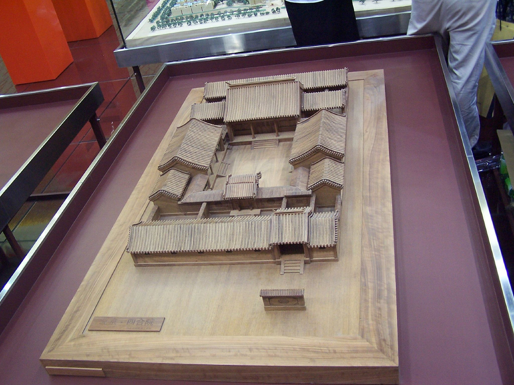
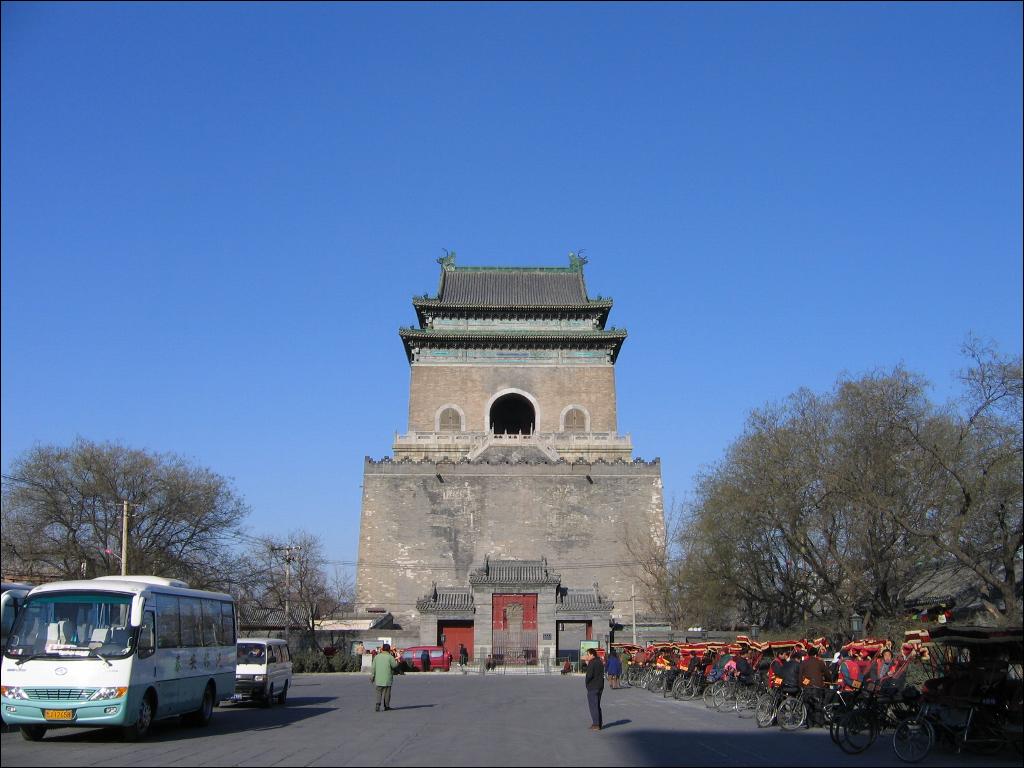
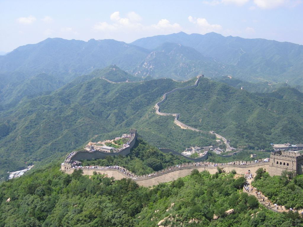
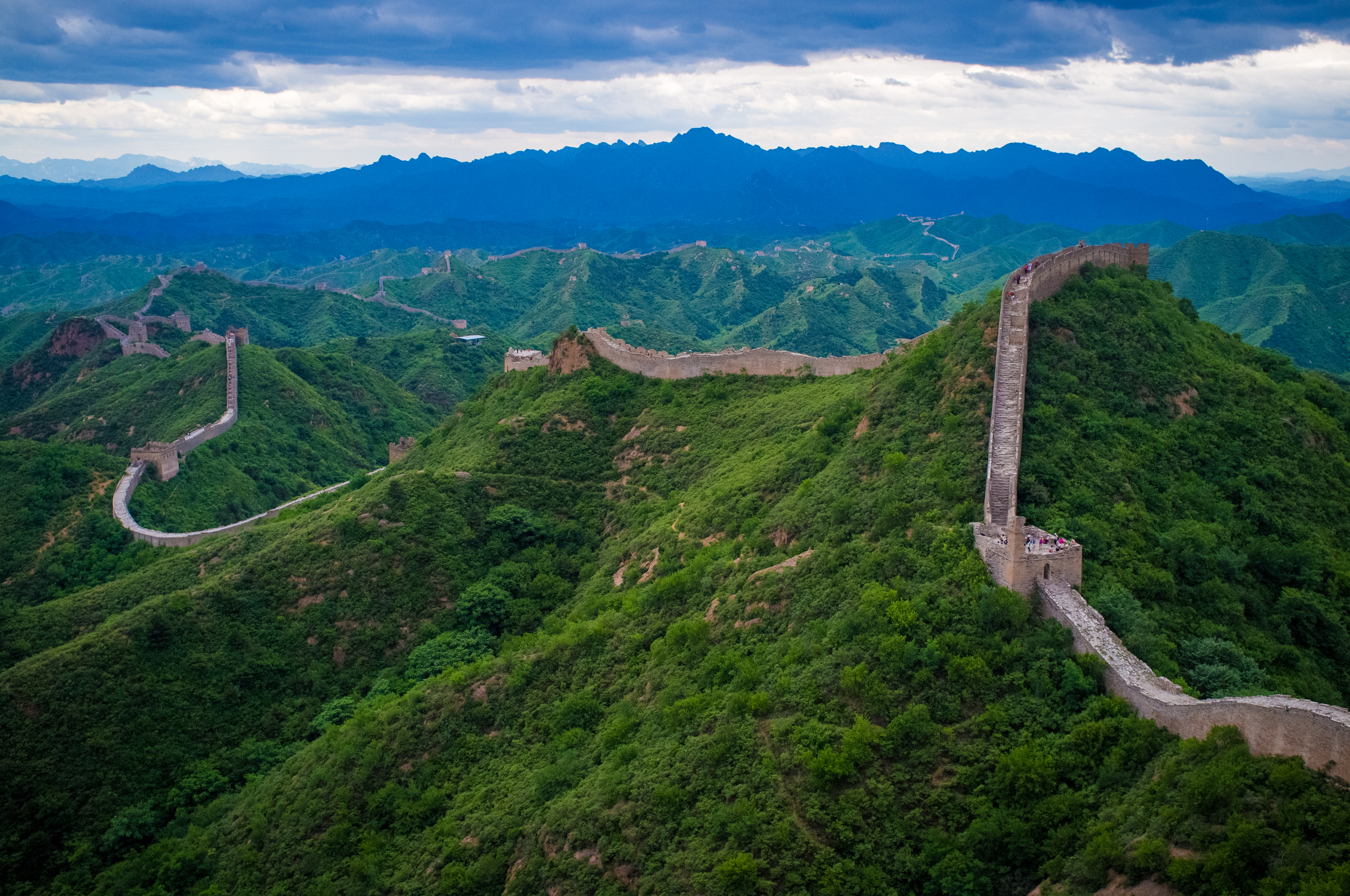
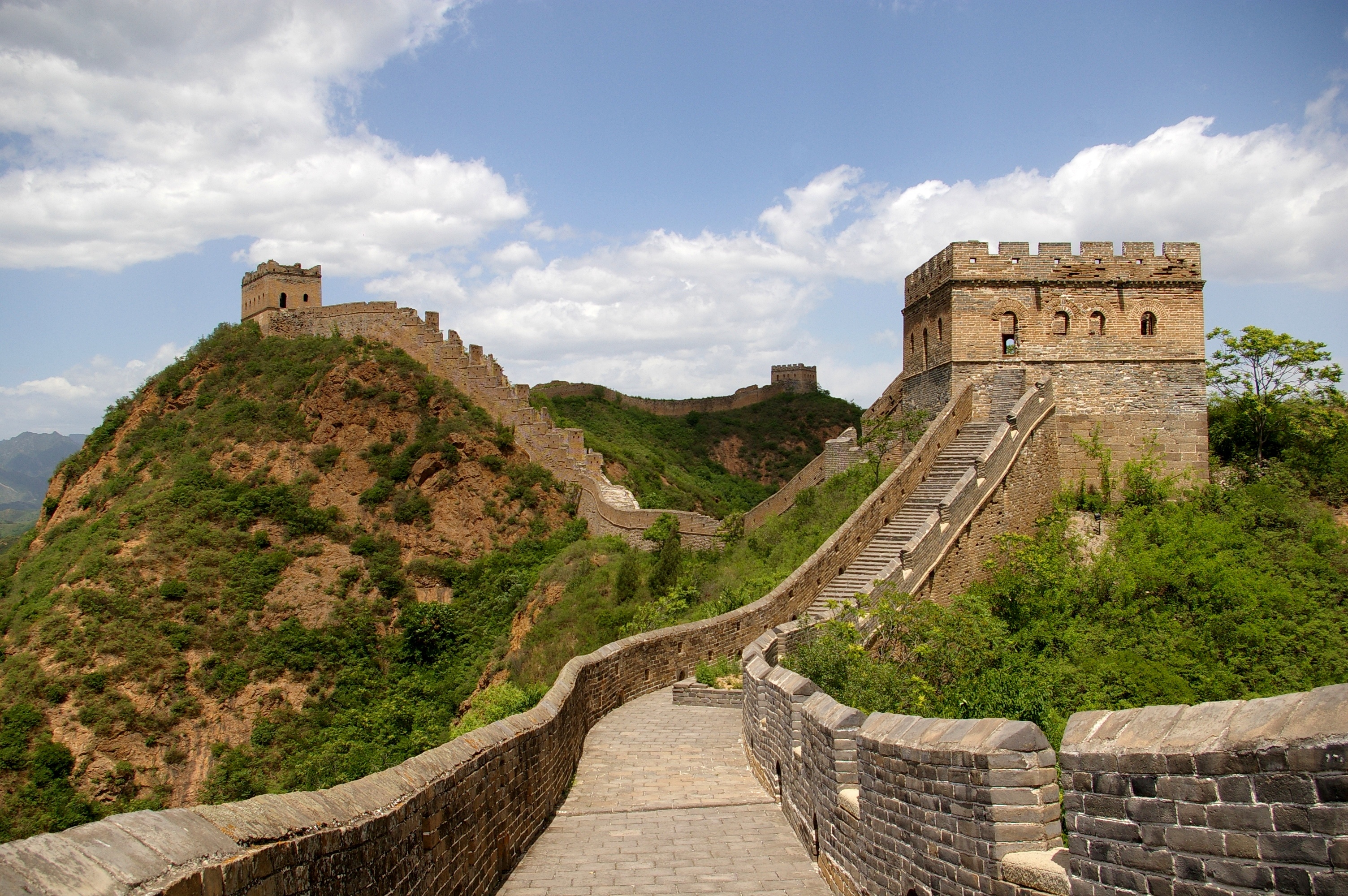
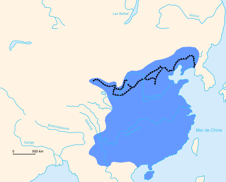
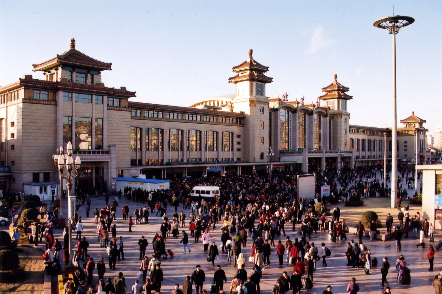
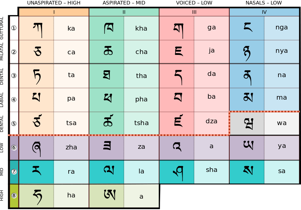
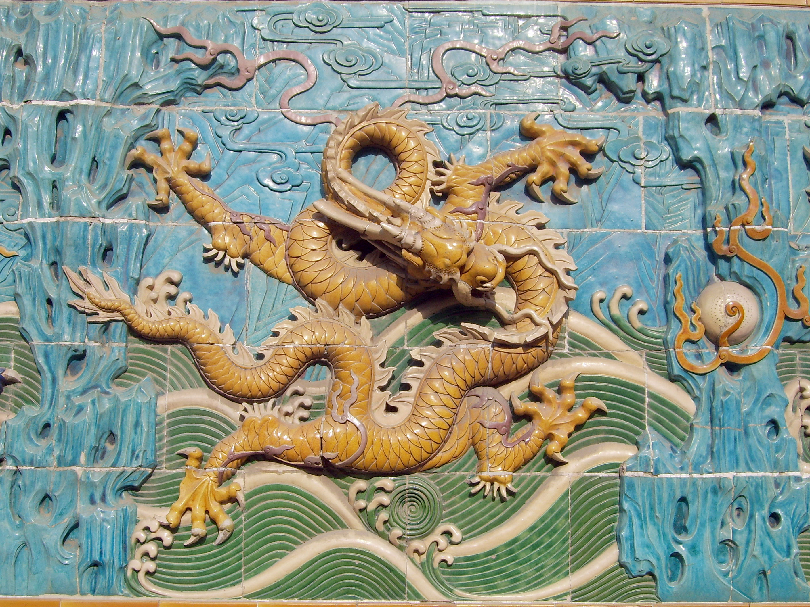