|
Reflections 2015
Series 10
June 27
Galápagos I – Guayaquil – The Islands - HMS Beagle
| | Essential Travel Decisions "Ya can't get there from here." That's the punch line of a very old joke that's almost become part of the language. It's the one where a motorist stops a farmer along the road and asks directions to a certain destination. The farmer considers, then rejects, several routings. He finally decides "Sorry, son, ya can't get there from here." | | | | While literally an impossibility, by assuming that "easily" is understood, it becomes a real part of life. I knew a woman in Idaho who wanted to annually visit a resort in the Dominican Republic. She told me of the multiple flight connections across the western and southern US she had to take, and then she still had to spend a night in Miami before taking the final flight to the DR. It was just as bad on the return trip. So you see, that line is often perfectly true, that ya can't get there from here (easily). | | | | My bucket list never was lengthy because by the time I first put it together about ten years ago at about the time of Beverly's passing, we'd already been to a lot of places we'd wanted to go to. Then, as a solo traveler in the past decade, I added new destinations such as Antarctica, Siberia, South Africa, Polynesia, Japan, China, Australia, the Amazon, Atlantic Isles (with Greenland) and more, while continuing regular revisits to places in Europe, Canada, the US, and beyond. The recent revisits to Rideau Canal/Nova Scotia and Texas/Lower Mississippi attest to this. While revisits will continue to be ongoing, the bucket list of completely new places and new activities has gotten very short, the Galápagos Islands being one of the few "new" places left that I wanted to see. | | | | The problem was, I found that ya can't get there from here. Over the past decade, I must have taken out my online and hard-copy paperwork about the islands 4-5 times, each time deciding I wasn't ready to do it. The time that came closest to my including it in an itinerary was in 2009, when I wanted to go to the South Pacific. I'd already been to Rapa Nui/Easter Island (as part of the Antarctica trip) and had revisited Hawaii. Rejecting all the myriad Pacific islands that did NOT interest me, I made an itinerary of the Samoas, Fiji, and the Society Islands (Tahiti, Bora Bora, more) that did interest me. At this point I found that local connections in the Pacific are very difficult, since these islands are usually connected long-distance, such as to Australia/New Zealand, or US/Canada, rather than among each other. For this reason I decided to include New Zealand in that group, which made sense because of its Polynesian history anyway. But still, the Galápagos are in the middle of the Pacific, so why couldn't I stop there on the way back from Tahiti? | | | | It's because ya can't get there from here. Let me use tiny Rapa Nui/Easter Island as an example. It belongs to Chile, and there was a nice connection out of Santiago on the Antarctica trip, but it's in the middle of nowhere, considered extremely remote. Still, when I was flying back to Santiago, there were other transpacific flights continuing to New Zealand and Australia, so Rapa Nui/Easter Island is far less remote than one might think. But to the Galápagos? No such thing. The islands belong to Ecuador, and that's the only connection they have. | | | | | | The following almost sounds like a joke, but it's true. The Galápagos are one of the very few places on earth that had absolutely no native population present when, during the Age of Exploration, Europeans first arrived in 1535. There was just the fauna that people go there to see today, and flora. And rocks. Nothing else. There is no evidence that mainland South Americans, or even the Polynesians, who left the southwestern Pacific and went clear north to Hawaii, and even way to the southeastern Pacific to remote--remote!--Rapa Nui/Easter Island, ever found or settled the Galápagos. I suppose those wise Polynesians discovered really early on what is so evident today: ya can't get there from here! |
| | | | Guayaquil (gwa.ya.KEEL) is Ecuador's largest city, and more or less on the coast. Everyone going to the Galápagos HAS TO go through Guayaquil. And while it might be possible (though inadvisable, because of flight delays) to connect directly to a flight to the islands coming in from overseas, it's much wiser (and you'll be more rested) to spend a night in Guayaquil, both coming and going. If this sounds like the plight of the Idaho lady in Miami, you are indeed getting my point. Ya can't get there from here. | | | | | | Someone might be tempted to check flight schedules to prove me wrong, and they WILL see that there are flights from Quito, Ecuador's capital up in the Andes and its second-largest city. But each one of those flights stops first in Guayaquil on the way to and from the islands—as a matter of fact, that's the standard three-stop route—which means that Quito passengers still have to stop in Guayaquil, as I said everyone does, although they won't have a change of plane. |
| | | | So, not wanting to add a visit to mainland Ecuador to my South Pacific trip, I left the Galápagos out of that trip, and these islands remained on my bucket list as the only Pacific location I'd wanted to see that I'd skipped. | | | | Beyond that, I feel it's a long, long way to go just to visit the islands by themselves for a week or so, although some people's work schedules limit them to that. But I've got the time and I also know how to do what I want to do less expensively, so I could lengthen the trip. So I began to consider stops on the mainland that I could join with it. Peru's Machu Picchu was a thought, but believe me, ya can't get there from here. That is, to try to connect these two countries, while possible, is difficult and awkward. I spent January and part of February this year online and on the phone with a couple of tour operators before giving up, so don't remind me of those weeks wasted out of my life. Peru would have to be another trip sometime. | | | | But then there was mainland Ecuador. Historic Quito, way up in the Andes, was an attraction, but even a few days there wouldn't extend the trip to a length I liked. But then I found something splendid of great interest, which had the additional advantage that it would also connect up to Quito. The century-old, spectacular rail line going up into the Andes from Guayaquil to Quito had been rehabilitated for sightseeing. There are short local services for local sightseers, and a beautiful new train called the Tren Crucero / Cruise Train, that makes the run in four days and three nights, with overnights spent in hotels that are historic haciendas. So there was a step forward. A schedule of 16 nights in the last half of May, with a week on the islands and a little over a week on the mainland. | | | | Now we're talking about "Essential Travel Decisions"—plural—and there was another crucial one I had to make, one that had held me back as much as the difficulty of reaching the islands. You may or may not agree that it was a problem, but it was very much one for me. I've been debating since returning from this trip how I would present this second decision, and I've decided to leave it until a later posting and talk about other important topics first. | | | | One more thing. Many trips taken lately have come in two parts, even within the same country, such as the Rideau Canal/Nova Scotia and Texas/Mississippi River. This trip, totally within Ecuador, also has two parts, but I've decided it's time to treat two different things separately. Therefore, while a possible name for this trip is "Galápagos & Central Andes: Ecuador" (that leaves it open for a potential later trip to continue in the Central Andes with Peru and Bolivia), I'm going to refer to the two parts separately and keep them apart. However, Guayaquil, as large a city as it is, is not a destination city. Most outsiders that go there are doing so just to get to and from the Galápagos, so I'm including Guayaquil on the mainland within the narrative sphere of the islands, hence the restricted title of this posting. | | | | Departure As usual, I'd planned this trip months in advance, but "bumps in the road" began to appear when the departure time got closer. First, Middlebury holds its annual reception just for the Language Schools at the Roger Smith Hotel in Manhattan usually in April (in addition to the one for all graduates in December), and I usually go with friend Allan, but the reception was delayed this year, and was announced for the very same evening I was leaving for Ecuador. Then, friend Paul said he was giving a talk for the World Ship Society that I wanted to attend, but it had been scheduled for my last night in Quito, with me flying back the very next day. So scratch two events I'd wanted to attend from the calendar.
| | | | Then, when I got to JFK the evening of the departure with plenty of time to spare for the scheduled 10:20 PM departure on LAN Ecuador, on arrival at the airport I was told that the incoming flight was seriously delayed, and that my outbound flight would be leaving instead at 3:15 AM. The only consolation was a $20 meal voucher that was handed out, which I preferred to exchange at a deli for a sandwich meal in the middle of the night. | | | | A horrendous delay like that would normally cause more problems down the line, but actually, this delay wasn't so bad. The original arrival time in Guayaquil was a horrible 4 AM, and so I'd arranged for a private pickup to take me to my hotel. I'd then contacted the hotel telling about an early arrival, and had hoped to take a nap before a tour I'd arranged for at noon. But this way, I actually arrived in Guayaquil just before 9 AM, and fortunately, the pickup had checked, and met the delayed flight instead. Now THAT was a relief. So on arrival, I did have time to freshen up, but not to grab some sleep, before my noon activity. (I napped afterwards.) | | | | I know some people aren't too clear about geography, so whenever South America is involved in a trip, I feel it worth explaining the following: despite their names, North America and South America are NOT north and south of each other, as this map of the Americas will indicate. | | | | A more accurate name to describe actual positions would be Northwest America and Southeast America. Confirm that north of "South" America is just the North Atlantic Ocean, and that south of "North" America" is the South Pacific Ocean, confirming the diagonal nature of the two continents. And while we're looking at the Pacific, click to find the Galápagos Islands, on the Equator, as is Ecuador (hence its name), but well out to sea, just under two hours' flight from Guayaquil. Finally determine the odd fact that, because of the diagonal nature of the two continents, my flight was indeed just about due south, from the east coast of North America to the west coast of South America. It was not a long flight, as long flights go, just a scheduled 6h40, way under my present threshold of 10h00 to be included in my list. (The list is in 2014/12, Ctrl-F "Long", and includes nine flights of over ten scheduled hours.) My return flight at the end of the trip was for 6h45, and during the day and evening, not overnight. | | | | A bit about time zones. I am NOT a proponent of daylight-savings time. On the other hand, if someone sees advantages to it, then another choice is having permanent daylight time in a given time zone. But in any case, we have this odd situation. New York and the US east coast are in exactly the same time zone as Ecuador (and Peru), UTC –5, as you can estimate by the flight being due south. But in the summer months, the US goes on daylight savings time, and the east coast is then at UTC-4, and becomes out of step with Ecuador by an hour. The Galápagos, being farther west, are one hour earlier than Ecuador, at UTC-6. So if I made this trip in the winter, I'd have two time zones to deal with, but in the summer, it's three. | | | | A word about currency substitution, based on the fact that Ecuador uses the US dollar as its currency. For various financial reasons, many small countries use the currency of another country, either exclusively, or alongside its own currency to which it's pegged 1:1 or sometimes 2:1. This can be de jure currency substitution, where it's legally mandated, or de facto currency substitution, where local people feel safer using a stronger currency than their own. I'd like to discuss this backwards, ending with Ecuador and the US$. | | | | A number of currencies are used logically in adjacent areas. It's no surprise that the Swiss Franc is used in Liechtenstein and that the Hong Kong dollar, as we saw during that visit, is used in Macau. Similarly, the New Zealand dollar is used in some nearby islands, the Australian dollar is used in some nearby islands, and the South African rand is used in four areas bordering it, Namibia, Lesotho, Swaziland & Zimbabwe (which also uses others). | | | | It will also not be not much of a surprise that the euro is used in tiny areas that are NOT part of the Eurozone, but just where you'd expect it to be used: Andorra & Monaco; Kosovo & Montenegro; San Marino & Vatican City. More further afield, the euro is also used, alongside other currencies, in North Korea & Zimbabwe. | | | | The US dollar is used not only in nearby areas, but in a number of areas not immediately adjacent. Using the US$ alongside local currency are: Bermuda, Bahamas, Barbados & Haiti; Belize & Costa Rica; Uruguay; but then also Iraq & Lebanon; Liberia & Somalia; Cambodia, and finally, alongside other currencies, in North Korea & Zimbabwe. | | | | And finally, the US$ is the exclusive currency in the British Virgin Islands, Turks & Caicos Islands, and a number of other Caribbean and Pacific islands, plus in three Latin American countries, El Salvador, Panama (since 1904, uses own local coins), and Ecuador (since 2000, uses own local coins). | | | | I have to admit, this is the first time I've come across this to this extent, not having to use anything other than what's in my own pocket in another country. But one unusual thing did come about. When I wanted change of $5 in singles for those obligatory tips to drivers and guides, the hotel clerk opened a roll of Sacajawea US$1 coins, with the copper core clad in brass, the so-called "golden dollar". They've proven unpopular with the US public, and I'd never seen one, so these might be the first ones I've ever handled—in Ecuador! | | | | Guayaquil As we said, large as Guayaquil is, it's not a destination city. The Frommer book doesn't give it any stars at all (while Quito gets three out of three), and points out that people only go there because it's the gateway to the Galápagos, which was exactly my reason for doing so. But I have fond memories of my two stops there, including the full day the first time, and partial day returning from the islands. This doesn't even include changing planes there to fly home at the end of the trip! | | | | I did feel it was worth it when planning not to try to make an immediate connection to the islands, and, given the late arrival, an immediate connection may or may have not worked out anyway. In addition, I didn't want to arrive in the islands exhausted, which, as you'll see later, was unwittingly extra good planning, since the first day in the islands was thoroughly exhausting enough and arriving with minimal sleep after an overnight flight would have been, well, foolhardy. | | | | So with my morning arrival, I had a full day and night in Guayaquil, and I wanted to see a bit of the town, particularly the Malecón 2000 that I'd read about. | | | | Now as readers have seen, I find it very easy to show myself around town whether I've been there before or not; just review New Orleans, Ottawa, Québec City, Hong Kong, Macau, and more. But some places in South America are different. Guayaquil in particular, has had a reputation for street crime in the past. The authorities have beefed up police presence downtown (and I did see that), especially at each entrance to the Malecón, but still, I wanted someone to take me around. That's also why I had someone pick me up at the airport. As part of my plans, I arranged for a couple of private tours and pickups, and was amazed at how reasonable in price doing so was in Ecuador. | | | | | | There were only two other places in Ecuador where I found myself alone. It was pointed out to me more than once that Puerto Ayora, the very enjoyable capital of the Galápagos, and where I lived, has no street crime whatsoever, and I believe it. I walked around everywhere and was very comfortable. The historic center of Quito, where I also stayed, has a very beefed-up police presence, and I had no trouble there either doing my usual solo walkabout in those charming streets. And yes, in Quito I did see plenty of guys wearing vests saying Policía Turística. |
| | | | I was going to hold off on the map of mainland Ecuador until we got to that part of the trip, but copy and paste this now, for a preview:
http://www.ezilon.com/maps/images/southamerica/Ecuador-physical-map.gif
| | | | The purpose of this map preview is to see just where Guayaquil is. I said it's more or less on the coast, and you can see that it's somewhat inland, but on a huge estuary, where essentially the coast comes inland to meet it. The estuary is at the end of the Guayas River, which, after you picture the Amazon basin, you will understand is the most significant river in South America that does NOT flow into the Atlantic. It also has the largest watershed west of the Andes. While I've read of a fanciful legend as to the origin of the city's name, I had to promulgate fantasy, so I'll mention that several historians claim that GUA comes from the local word HUA (land); YA comes from ILLA (beautiful prairie), and QUIL comes from the local Quilca tribe, so a very rough translation of "Guayaquil" might be "beautiful Quilca prairie land". Or not. | | | | This is a regional map of the Guayaquil area, to get an idea of the size of the Guayas. The downtown with the Malecón is where the city's name is written; the big bridge connects the city of Durán, from where we'll be taking the train to Quito later, with the diagonal strip showing the airport, where we arrived and where the nearby hotel is. Actually, I was quite pleased as to how I worked out the hotel. The Sheraton Guayaquil is a five-minute drive from the airport, and I was able to book it free on Starpoints, both before and after going to the islands. But I chose to do something that I always do when a Sheraton has a Club Floor. On this floor, for only $30 extra per night, you get free internet in your room, and have access to the Lounge, which has an included hot breakfast and evening snacks with a happy hour, which serves quite well for dinner, especially since some of the hot snacks were Ecuadorean specialties. It's really worth it.
| | | | So after freshening up, I went downstairs at noon to meet my guide and driver, and we went out into the heat, which for me, is always a huge problem. The van was air-conditioned, and that's what saved me. Copy and paste these two maps:
http://www.zonu.com/images/0X0/2011-11-03-14798/Sector-norte-de-Guayaquil.jpg
http://www.zonu.com/images/0X0/2011-11-03-14796/Centro-de-Guayaquil.gif
| | | | Note that both maps are turned sideways, looking west with north to the right!!! As you can easily read within the first link, that map (click) shows the Sector Norte de Guayaquil, that north area with the airport. At the bottom is the bridge over the Guayas to Durán, and beyond the airport is the conveniently nearby Sheraton Guayaquil at #3 (misidentified in the table). Now move south (to the left!) past Cerro del Carmen (Carmen Hill), and you'll get to the next map, whose link tells you it's the Centro de Guayaquil, on the other side of the Cerro del Carmen (click). We'll work mostly with this map. | | | | | | It should be noted that Guayaquil was founded in 1538 and apparently had significant colonial architecture as well, but the city was hit by a major fire in 1896, which destroyed large portions. Still, there are handsome beaux-art civic buildings and banks downtown, especially along the Malecón. |
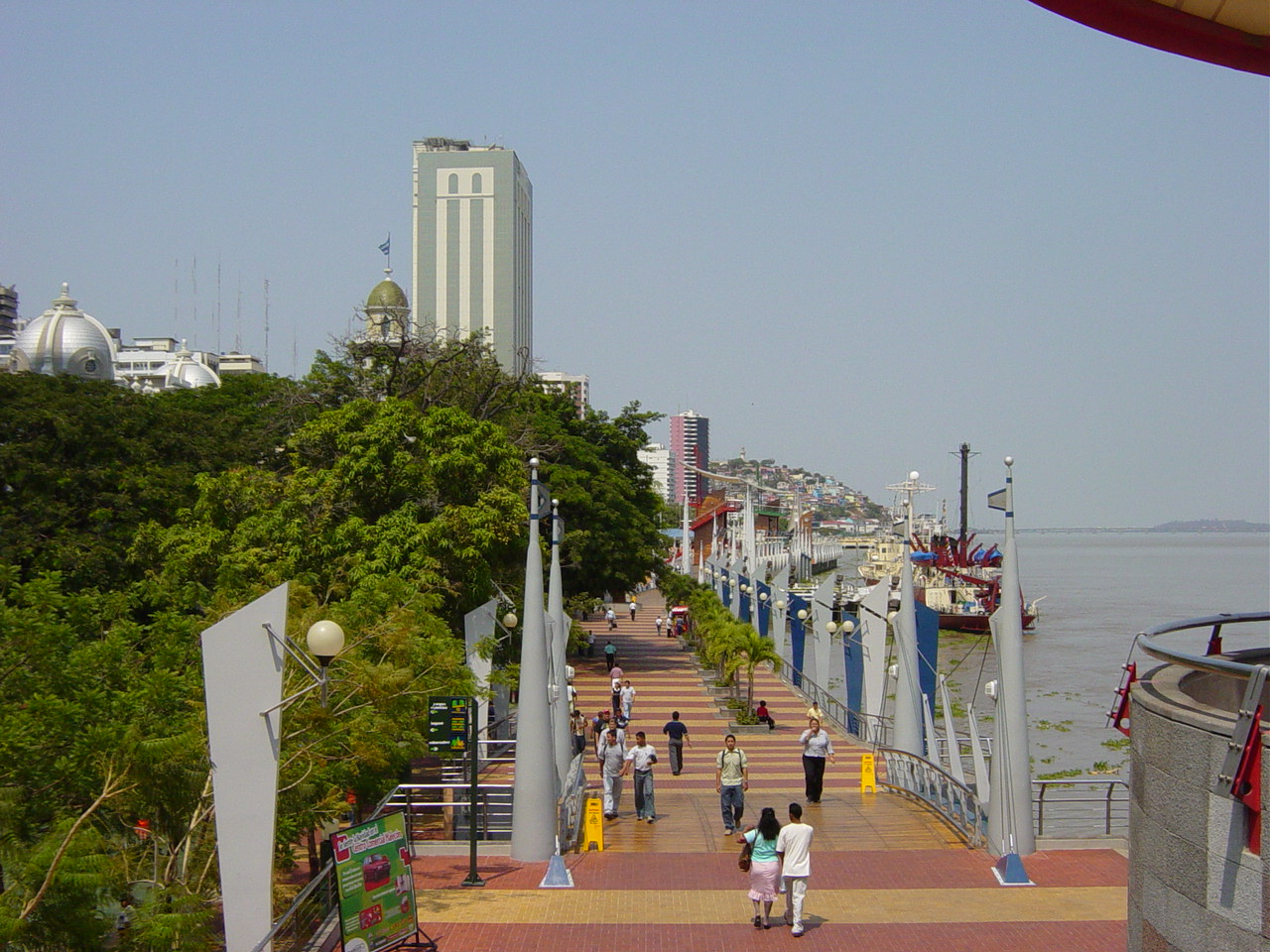
| | | | I've always liked the Spanish word malecón (ma.lé.KONN) --it just rolls off the tongue. I know what it is, but have to find a good English word. I suppose the best word is "embankment", a wall built in a town to support a riverbank or seafront. But the malecón also becomes a landing for ships; a road along it, or a pedestrian walkway along it, can be a Riverfront Promenade (or Seafront Promenade) or Esplanade—it's just a wonderful area where town meets water. Then, by extension of meaning, it can be a jetty, dock, or pier. Probably the most famous Malecón is the one in Havana—but I've never been there. | | | | There has been a malecón in Guayaquil since the colonial period, which was extended in the 19C—this is a view of the Malecón in 1920, with the Cerro del Carmen on the left and Cerro Santa Ana (with Las Peñas) straight ahead. But it was in decline in the 20C and by the 1980s, parts were falling into the river, and it was a dangerous place. With the turn of the millennium, it became an urban renewal project called Malecón 2000 (Dos Mil), to be ready by that year as a showplace. And this is what I wanted to see, as one of five million visitors since it opened, one of the most visited places in the city. | | | | I had foolishly considered I would walk its 2.5 km (1.5 mi) length (see second map) which has gardens, pavilions, monuments, museums, fountains, and a lot more, but the heat in particular, and also lack of sleep, made that impossible, and anyway, you don't have to see every little bit of what is basically a large park. So the guide very cleverly had the van stop at three different locations to see the most important sights, which was a great solution. | | | | This is a general view of the promenade (Photo by Martin Zeise), again with Cerro Santa Ana and Las Peñas in the distance. As you walk along here, you come across sculptures themed to the four elements, water, fire, earth, and air, with fire and earth doubling up as timber-and-metal lookout towers crowned by sail-like awnings. I understand the views from the top are striking, and the guide asked if I wanted to climb one, but in the heat, I just didn't have the energy, and the view from the ground over the river would have to suffice. Then, on the other hand, I found the following rotating panoramic view from atop one tower, which we can all enjoy together:
http://www.ecuador360.travel/index.php/ciudades-de-ecuador/guia-de-atractivos-de-guayaquil/malecon-2000-torres-elementos
| | | | Of the several things we stopped to see, two stand out, and are at the opposite ends of the Plaza Cívica / Civic Square at #12 and #15 on the second map.
http://thumbs.dreamstime.com/x/moorish-clock-tower-guayaquil-view-malecon-boardwalk-ecuador-51129975.jpg
http://upload.wikimedia.org/wikipedia/commons/1/18/Guayaquil_LaRotonda_Bolivar_SanMartin.JPG
| | | | At #12 is the 22 m (72 ft) Torre Morisca / Torre del Reloj (Moorish Tower / Clock Tower), brought from England in 1842, a local landmark. Opposite it is an example of one of the beaux-arts buildings in the area. But the major centerpiece of the Malecón is La Rotonda at #15, which, amid South American flags, has statues of the liberators José de San Martín and Simón Bolívar, who both had fought against the Spaniards, shaking hands at the time of there meeting in Guayaquil in 1822. Guayaquil had become the first city of Ecuador to gain its independence from Spain—the rest of Ecuador followed later—and these two leaders were trying to decide the future of the Free Province of Guayaquil as it fit into a free South America. | | | | Around the area of the Rotonda there were a number of banyan trees (Photo by Clinton & Charles Robertson), like this one in Florida. Banyans are those wonderful, all-encompassing, massive, beautiful trees with roots extending down from their branches, and the guide suddenly spotted, and pointed out to me, an iguana running up a banyan trunk. Thus began my first ever live encounter with an iguana, encounters which continued for a week in the islands, not every day, but close. | | | | When the guide saw my interest, he said he had the perfect place to take me. I'm not sure if he had been planning to go there or not. If not, the iguana in the banyan was the spark. This is what I like about either going on your own, or having a (not-too-expensive) private guide. Later he asked if I wanted to stop at a craft market, and I wasn't interested, and he dropped it. You cannot add and subtract so easily—actually, not at all--when there are other people on a tour. | | | | The first time I ever heard of an iguana—and I think this might also be true with many readers—was when I saw the 1964 film version of The Night of the Iguana with Richard Burton, Ava Gardner, and Deborah Kerr, directed by John Huston. I now learn the film was based on Tennessee Williams' 1961 stage play, based on a 1948 short story of his. Thus my awareness of iguanas has had a gap between the film in 1964 and the banyan tree in 2015. Copy and paste to see cast member Sue Lyon confronting a tethered iguana in the film:
https://bluenred.files.wordpress.com/2010/07/a-john-huston-the-night-of-the-iguana-dvd-pdvd_014.jpgv
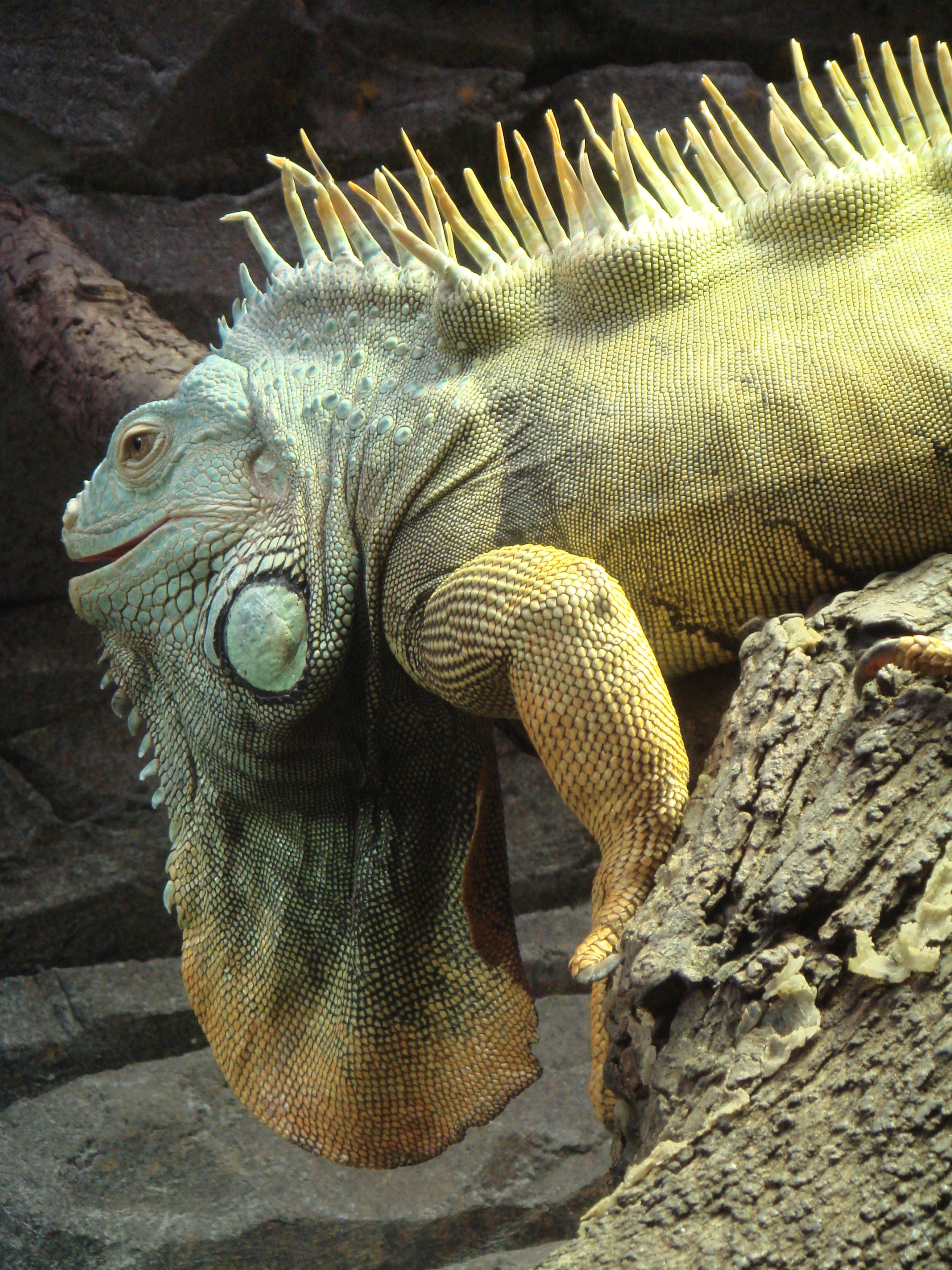
| | | | But more research has now told me (so much of this comes after-the-fact) that the iguanas in the Galápagos are of different species from what I saw in Guayaquil (and, famously, of different species within the islands themselves, which is part of the whole point, isn't it?) The definition of an iguana is an herbivorous lizard native to tropical areas of Mexico (as in the film) and the Caribbean through Central and northern South America. The main one of the two species is the green iguana (Photo by Manuel de Corselas), and from what I can tell, that's what I saw in Guayaquil (more pictures follow, in which you can see their variety in size). The green iguana is the one usually simply referred to as an iguana. Both mainland species possess, as the picture shows, a dewlap, that flap of skin hanging below the jaw, and a row of spines running down their backs to their tails. The ones I saw on the islands had the spines, but not the dewlap. The spines are for protection, and the dewlap helps regulate body temperature, and is used in courtships and territorial displays. Oddly, like many other lizards, when grabbed by the tail, the iguana can allow it to break off so it can escape and eventually regenerate a new one. I did NOT check to see if that was true. | | | | Look at #6 on the Guayaquil map, just a few blocks away from la Rotonda at #15. This is where we drove in the van. It's a public park officially called Parque Seminario, presumably after a former seminary that had been there, although now there are just office buildings and a church on the perimeter. But everybody knows it instead as Parque de las Iguanas / Iguana Park, and you'll see why. Copy and paste these four links:
http://upload.wikimedia.org/wikipedia/commons/f/f9/Ecuador_-_Guayaquil_-_Parque_seminario_-_Parque_de_las_iguanas.jpg
http://media-cdn.tripadvisor.com/media/photo-s/01/3e/a9/22/parque-de-las-iguanas.jpg
http://moon.com/wp-content/uploads/2014/06/Guayaquil_Ecuador_ParquedelasIguanas_WindellOskay_CC-BY.jpg
http://www.hotelcontinental.com.ec/bundles/content/files/1/galerias/secciones/14_parque-de-las-iguanas/neutral/cabecera/1.1.1.1hotel_continental.jpg
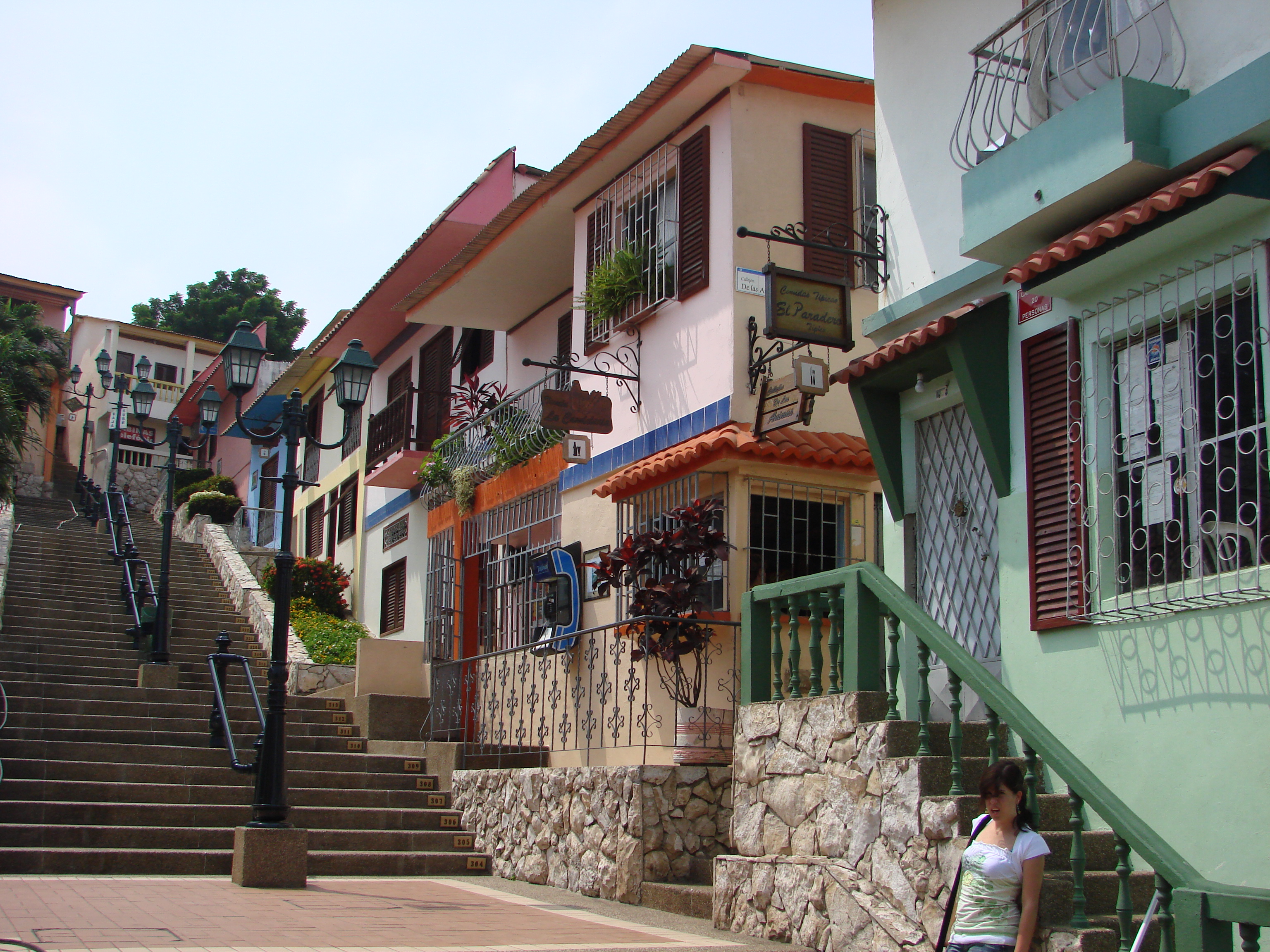
| | | | Iguanas have been gathering here since people in nearby buildings started to feed them regularly. You can see how large some of them are, though others are half the size of the biggest. Although I'm sure they'd fight back if you did something stupid, they're quintessentially tame, both here and on the islands. I particularly like the last picture with the pigeons, which probes a point of mine. In Guayaquil and the islands, too, iguanas are about as common as pigeons (or squirrels, elsewhere). Just as you would notice, but usually not pay much attention to, a pigeon, that's the situation that develops with iguanas after a while, even to wide-eyed visitors like we are. Some people are feeding them in the park, just as they do pigeons. But it's really wonderful getting to feel at home with iguanas as you would with the much more familiar pigeons or squirrels. It's a huge advantage of travel. | | | | Our next stop was a place I mentioned earlier—I've taken to doing that stylistically, so when we get there, the name will already ring a bell—the hill Cerro Santa Ana, with the neighborhood of Las Peñas on and around it. Find it on our downtown map. It clearly stands out, as we saw in a photo earlier, at the north end of the Malecón. Since the hill is right at the water, Las Peñas is the oldest neighborhood in the city. It had gone into serious decline, but now many, possibly most, of the century-old houses in the four-century-old neighborhood have been refurbished, and converted into art galleries and restaurants, making it the artistic center of the city. Although it didn't strike me at the time, Las Peñas means The Rocks, an amazing parallel to the historic neighborhood in Sydney, with that very name, adjacent to the Sydney Harbour Bridge and not far from Circular Quay (2010/19). | | | | The van dropped us off at the bottom of the hill, looking up the long staircase cutting through Las Peñas, which has 444 numbered steps. Click on this view of the staircase (Photo by Belen Rios), and you'll see that the numbers start with 304, which means the picture was not taken at the bottom, where the guide and I were standing. Needless to say, with the heat, I did not opt to climb the stairs, but here's a revolving panoramic view around the area of the stairs on the Cerro Santa Ana:
http://www.ecuador360.travel/index.php/ciudades-de-ecuador/guia-de-atractivos-de-guayaquil/cerro-santa-ana
| | | | Fortunately, the guide said we can see Las Peñas just as well down at ground level, so we walked a few steps (check the map) to Avenida Numa Pompilio Llona (Photo by Freddy eduardo) to its end, where the van met us again. And again, we have a revolving panorama along this street:
http://www.ecuador360.travel/index.php/ciudades-de-ecuador/guia-de-atractivos-de-guayaquil/barrio-las-penas
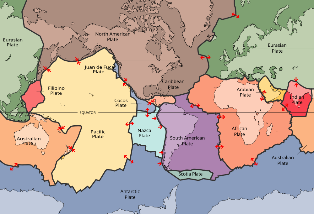
| | | | On the map you'll see that the Cerro del Carmen is adjacent, and we drove to the top for a southerly view over Guayaquil (Photo by Marc Figueras), mostly showing the area of the Malecón and the Guayas River Estuary looking out toward the sea. | | | | He wanted to drive me around to more neighborhoods, just to look at them from the air-conditioned van, so I agreed. When they dropped me off at the Sheraton, I took a shower (the heat!) and then my postponed nap. In the evening I went to the Club Lounge for the free happy hour with wine, and grilled Ecuadorean snacks. | | | | The next morning, it was off to the airport, where I'd booked a round-trip flight on TAME Airlines to Baltra, in the Galápagos. I used the free hotel shuttle, and also arranged for that same shuttle to pick me up a week later when I returned to the Sheraton for the train trip. I knew there were two bothersome fees to be paid, both in cash, so I was carrying around more cash than I ever would. The fee to be paid while still in Guayaquil, a so-called "transit tax" had just gone up from $10 to $20, so on arrival in the very modern airport, I looked for where that was to be paid, and saw no directions. So I waited in line for about 20 minutes at the TAME counter, to be told I needed the fee paid first, and she finally directed me where to go. I waited on that line to take care of it, and interestingly, the form you filled out for the fee had you stating that you're bringing no foodstuffs into the islands, and they x-rayed your bag to be sure as an agricultural check, some people getting a hand-check of their bags as well. But then there was no wait at all back at the TAME counter, and off I went. | | | | It's just under two hours, actually, about 1h50, to fly the 906 km (563 mi) from Guayaquil due west, pretty much right along the equator, though slightly south of it, to Baltra, and I had the $100 in cash ready to pay the Park Entrance Fee that every visitor pays, collected in Baltra. The high fee is used to finance park improvements. The flight was pleasant, and we landed on Baltra at the scheduled 11:30 to a bit of haze, moving into a bit of a drizzle. I could only imagine what adventures—and misadventures—awaited this planeful of naïve arrivals. | | | | The Islands I've always admired James Michener and his writings. I'd go so far as to say his way of looking at history around the world as existing in layers, then fictionalizing that history, has inspired me to understand my travels better—he has helped educate my and my understanding of the world. He used a wonderful reverse technique in The Source, where he told the history of the Middle East backwards. (This is à la Harold Pinter—see the opening paragraph of 2011/2, and more recently 2015/6.) He had an archaeologist excavating a tel (as in the name Tel Aviv), which is an archaeological mound created by human occupation, then abandonment, of given site over centuries and millennia. The archaeologist cuts a pie wedge in the tel, layer by later, and discovers more recent habitation and abandonment, then below that an older one, until he reaches bedrock and the first people who lived there millennia ago. The top of the tel had a spring, and that proved to be the binding thread from layer to layer, each occupation centered on a water source. The spring is of course still there at the very bottom, at which point one begins to wonder about the name of the novel. Does The Source refer merely to that spring in the tel, flowing up through all the layers, or is the title symbolic of these layers of history being the source of modern civilization? | | | | But equally instructive was the first Michener book I ever read, Hawaii, particularly appropriate now since we're talking about the Pacific. Here, Michener layers his fictionalized history in the normal forward sequence, literally from Day One, something I can describe by memory after having read the book so long ago. First there's just ocean. Then magma bursts forth from a hotspot in the sea floor to form volcanoes, and islands around them, which are bare. Then migrating birds stop at the islands, and perhaps in their droppings leave undigested seeds that propagate to form original flora. Coconuts wash ashore and palm trees grow along the beaches. In time, Polynesians arrive to inhabit these islands, then many other national groups, in sequence over time, including Portuguese, Americans, British, Filipinos, Chinese, Japanese, and with each fictionalized arrival, Michener paints the multiethnic character of modern Hawaii. Wonderful stuff. | | | | I state this now, because I want to channel Michener in talking about the Galápagos. Here, too, we start with nothing but empty ocean until we get volcanoes rising from beneath the water. But it's more than just a hotspot as in Hawaii, because here we have a situation of tectonic plates, such as we last discussed when we saw the mid-Atlantic Ridge splitting Iceland (2012/6). In our present area we have the Galápagos Triple Junction grinding away along the Pacific floor. The map colors emphasize tectonic plates, so first adjust your eyes to find the continents, particularly the Americas, then locate the large Pacific Plate (Hawaii can be seen in its upper center). To its east are two smaller plates, the Nazca Plate abutting South America and the Cocos Plate abutting North America. Where the three meet at a triple junction is just west of the Galápagos Islands. But this junction is not just a simple intersection. There are two microplates the Galápagos Microplate and the Northern Galápagos Microplate. These are caught in the junction and revolve according to the whims of the larger plates. | | | | The islands themselves, though, are located on the Nazca Plate, which moves ESE and is pushing under the South American Plate at the rate of about 6.4 cm (2.5 in) per year, which explains why the Andes exist. (Also keep in mind how the India Plate rammed into, and under, the Asian Plate, pushing up the Himalayas along with Tibet [2014/8]). In addition to this plate activity, the islands, like Hawaii's hotspot, are located above the Galápagos hotspot, where magma rises to the surface, forming volcanoes. | | | | Before we continue, it's time to look at our excellent map of the Galápagos Islands (Map by Eric Gaba, modified by Matthew Stevens). I can legally link to this (with attribution) because it's in Wikipedia, but we'll need this map as we move on, so let me give you the same link so you can keep it in another window:
http://upload.wikimedia.org/wikipedia/commons/thumb/4/4a/Galapagos_Islands_topographic_map-en.svg/2000px-Galapagos_Islands_topographic_map-en.svg.png
| | | | Study this map carefully (click), and get used to the islands, since we'll be making frequent reference to many of them. The first point can continue about the plates, that the Galápagos are moving in a different direction from Hawaii, which apparently is moving WNW on the Pacific Plate. Those tiny islands were over the hotspot very long ago; of the major islands, Kauai, Oahu, and Maui are older, and have passed over the hotspot long ago as well. As the plate moves WNW, it's the Big Island of Hawaii that's sitting over the hotspot today, which is why the active volcanoes are there. | | | | Now go back to the Galápagos map. The story is the opposite here, since the plate is moving ESE. Española, on the lower right, is the oldest island at about 3.5 million years, and has long since passed over the hotspot as Espanola moves closer to South America. Actually, it's believed that there were other islands further east of Española that developed anywhere between 8 and 90 million years ago, but they have since sunk under the sea. (!!!) | | | | On the left, it's Isabela and Fernandina that have the volcanoes today as you can see, and Fernandina, being furthest to the west, is the youngest of the islands. Most articles quote 2009 as the last eruption on Fernandina, but they are not up-to-date, since the most recent eruption on Fernandina happened in the midnight hours between 10-11 April this year, and continued for some 20 days, with steam and gas being emitted along with lava flows. | | | | Since we have the map in front of us, let's discuss what we see, and then get back to our Michener-style historical development. The listing I've seen says that the Galápagos consists of 18 main islands, 3 smaller islands, and 107 rocks and islets, but that's the sort of statistics made up by bean counters; I can't be sure which ones they mean are the main ones and which are the smaller ones, so forget that, because it'll just make your head spin. | | | | Do it this way. Let's divide the islands up into four logical groupings. Start in the center with Santa Cruz, which includes the biggest town, Puerto Ayora. This is not only because I'm strongly prejudiced in favor of this island and town, it quite frankly really is the center of things. The only other larger island in the center is San Salvador/Santiago. But the center grouping is the one that has some smaller islands of importance. Most obviously, we have the already-mentioned Baltra, where the main airport is, just across a channel from Santa Cruz. The other small islands in the center group are North Seymour, right above Baltra (also called South Seymour). North Seymour shows that good things come in small packages, because I think it's an absolute gem. East of Santa Cruz is even tinier South Plaza (Plaza Sur), another gem. To the southeast is Santa Fe, and off San Salvador is tiny Bartolomé. I have no comments about few additional islands here. | | | | We've already mentioned the western cluster, the volcanic, and therefore newest islands, Isabela and Fernandina. Isabela is the largest of all the islands, and makes up close to three-quarters of the total land area of the Galápagos. The island's seahorse shape is the product of the merging of six large volcanoes into a single land mass. Note where the equator runs through northern Isabela. | | | | We now come to the southeastern grouping, and we can continue to use our tectonic thinking to remember these are the oldest islands. We have Floreana, Española (the very oldest), and San Cristóbal, which includes the awkwardly named Puerto Baquerizo Moreno, which is the second-largest settlement, and yet the capital of the Galápagos. | | | | Most remote are the small, northern islands. The closer cluster is Pinta (the home of Lonesome George, who we'll discuss later), Marchena, and Genovesa. Then look WAY to the northwest to find tiny Wolf and—sure enough—there actually is an island named Darwin, which is the northernmost island. | | | | I think you can see the prejudice I referred to developing in the previous four paragraphs, as to what is in boldface and what is not. Those are the locations I enjoyed, where I saw just about everything I wanted to see, and most heartily recommend. | | | | The islands have be come more developed in recent decades to the alarm of preservationists. However, only five islands are inhabited: (1) Santa Cruz, with its airport on adjacent (2) Baltra, and then continuing clockwise in an oval pattern, (3) San Cristóbal, (4) Floreana, and (5) Isabela. You will note on the map that there is a second principal airport on San Cristóbal. The one shown on Isabela is just a small airstrip used for provisioning and inter-island commuter traffic. The population of the Galápagos is 25,000, with about half, 12,000, in Puerto Ayora, which by far has the best infrastructure for visitors. As we know, the islands are particularly known for their vast number of endemic (found only here) species, and they and their surrounding waters form a province of Ecuador, a National Park, and a Biological Marine Reserve. The inhabited areas account for 3% of the area of the islands, with the remaining 97% included within the National Park. | | | | Let's now go back to channeling Michener, where we left off with bare, volcanic islands. How did the flora and fauna arrive in this case? Well, birds can fly in, so that's not an issue, but how about the flora and land-based fauna? | | | | I have now learned about oceanic dispersal, which is how organisms transfer from one land mass to another by crossing the sea. Looked upon jocularly, it's the same principle as a person getting on the Queen Mary 2 in New York and getting off in Southampton. But more fundamentally, it involves large rafts of floating vegetation—which is why the process is called rafting--that sometimes wash down major rivers in the tropics, and then out to sea. Not only is this an indication of "vegetation on the move", either by seeds or more directly, but small animals may be trapped in the floating raft and get transported as well. | | | | It's rather exotic for a land animal, such as an iguana or even a tortoise to "travel by raft" from mainland South America to somewhere like the Galápagos, but the transfer may take place much more simply, by merely swimming or floating there. Now tortoises are land creatures, and not sea turtles, and can drown in deep water. Tortoises reached the Galápagos from mainland South America about 2-3 million years ago. Surviving the distance involves the tortoises being buoyant and floating well, and also being able to extend their heads on their long necks above water to allow them to breathe. They also have the ability to survive up to a year without food or fresh water. Still, they do not swim well, yet had the advantage of the Humboldt Current moving in the direction of the islands. Also keep in mind is that all you need to start a population on a distant island is one pregnant female or a breeding couple, and it is believed that the founding population arrived either by rafting or swimming/floating. They probably colonized nearby Española and San Cristóbal first, then dispersed to all the other islands, establishing about 16 separate species on ten islands. There are only ten (perhaps eleven) species left today. | | | | Given how carefully the Natural Park and Biological Marine Reserve are monitored today, including rebreeding programs we'll discuss later, it's breathtaking to see how cavalierly the area was treated in the past. In the 16c there were over 250,000 tortoises, which declined to a low in the 1970s of about only 3,000. The tortoises were hunted for meat and oil, which lighted the lamps of Quito. Settlers established farms, which resulted in habitat clearance for the tortoises. Non-native species were introduced, such as goats, pigs, dogs, and rats, which killed young tortoises. The rebreeding programs, started in the 20C, have resulted in thousands of young tortoises bred in captivity being released into their appropriate home islands. It's estimated that by the turn of the 21C, there are about 19,000 giant tortoises in the Galápagos by one estimate, 20,000-25,000 by another. | | | | Now that we know which islands are where, we can better understand this map of the current and extinct species, broken down by sub-species, of the endemic Galápagos Giant Tortoise (Map by Fallschirmjäger). The 10 (or 11) subspecies break down as follows. There's one each on Santa Cruz, Santiago, Pinzón, San Cristóbal, and Española. Santa Cruz is the only island where visitors can see the tortoises on a practical basis, both in the wild, and in the breeding center in Puerto Ayora. There are five (!!!) species on Isabela, one on each of the main volcanoes: Wolf, Darwin, Alcedo, Sierra Negra, and Cerro Azul. That makes ten, and the iffy additional one is a possible eleventh on Pinta. It's considered that the death of Lonesome George in 2012 caused that subspecies to be extinct, but there is still some hope that some individuals might still be found. Thus the total of 11 is iffy. | | | | | | The Floreana subspecies is thought to have been hunted to extinction by 1850; Darwin in 1835 saw empty carapaces (shells) there, but no live tortoises. Actually, Floreana is in many ways an island of environmental tragedy. When still known by its old name of Charles Island in 1819, Floreana was destroyed by fire, and details of how it happened are known. The fire was set as a prank by helmsman Thomas Chappel from the Nantucket whaling ship Essex. It was the height of the dry season, and the fire soon burned out of control. When the ship sailed the next day, the island could still be seen to be burning, and even after a full day of sailing, the fire was still visible on the horizon. Thomas Nickerson had been the cabin boy on the Essex, and many years later he returned to Floreana and found a black wasteland, very little or nothing having grown back. It's believed that this fire contributed to the extinction of some species originally located on Floreana. |
| | | | Back to the Michener sequencing, where we find something lacking here. We've accounted for the flora and fauna on the Galápagos, and parallel to where the Polynesians started arriving in Hawaii, we should now be talking about the arrival of primitive peoples in the Galápagos. But as we've said, it never happened. There's no evidence of any primitive peoples ever arriving in these islands, not from Polynesia, not from mainland South America. This is really quite unique—the Polynesians even reached Rapa Nui/Easter Island, known for its remoteness. | | | | Well, leaving that chapter on native populations blank, we come to the arrival of Westerners during the Age of Exploration. And once again, it was by pure accident, and was similar to what we've discussed before. The first European landfall on Australia was when Dirk Hartog was blown off course in 1616 on his way to the Indies (Indonesia today) and he landed on the west coast of Australia. It was in the previous century, in 1535, that the Bishop of Panama, on his way to Peru, was also blown off course and landed in the Galápagos as the first Western arrival. He later described the islands and the fauna he found there. The islands appeared in an atlas published in 1570, and a crude map of the islands was made in 1684 by the buccaneer Ambrose Cowley. However, Cowley gave the islands individual names in English, naming them after some of his fellow pirates, or after British royalty and the nobility. | | | | For some three centuries, the Galápagos, centered on Floreana, were used as a base by buccaneers (such as Crowley), sealers, and whalers (such as the Essex). The islands gave them a sheltered anchorage, firewood, water, and food, in the form of the tortoises, which were caught by the thousands--more than 100,000 in the early 19C--and stacked alive in the ships' holds, since they could survive for a year without food or fresh water, as future sources of fresh meat. | | | | The islands then passed from their English phase to their Spanish phase when, at one point in this period, they were nominally taken over by Spain, which took little interest in them and did almost nothing to enforce its claim. This changed in 1832 when the new Republic of Ecuador claimed them from Spain and annexed them. This is the period when the current Spanish names appeared. | | | | It wasn't until 1807 that anyone lived there, an Irishman who was marooned on Floreana for two years. But with the takeover in 1832, the first governor of the islands brought over a group of convicts to form a penal colony on Floreana, along with some artisans and farmers. These few settlers, from continental Ecuador, were the only ones there for about a century. The last penal colony closed in 1959. | | | | For about the first third of the 20C, Ecuador was strapped for cash, and tried to sell the islands to raise funds. The US had repeatedly expressed its interest in buying them for military use, since they were well positioned to guard the Panama Canal, but nothing ever came of it. | | | | We've mentioned the English and Spanish names of the islands without much comment. Under normal circumstances, the former English names for the individual islands would have long since disappeared, but it's one event that has tended to maintain them in the background. Any ideas what that might have been? | | | | Well, it's Darwin's visit in 1835, which became world-famous. At the time, the islands had their English names, and they are not only what he referenced in his writings, including his popular book The Voyage of the Beagle, but which the official navigation charts of the expedition recorded. That's been sufficient to maintain them in the unofficial background ever since. Let's take a look at some selected current Spanish island names of interest.
| | | | A number of the islands, according to Spanish custom, have religious names: Santa Cruz (Holy Cross), Santa Fe (Holy Faith), San Cristóbal (St Christopher), San Salvador (Holy Savior) also known as Santiago (St James). An earlier name for Floreana was Santa María (St Mary). Some other ones of interest are named after people, such as Darwin, obviously. North Seymour (and South Seymour/Baltra) is named after Lord Hugh Seymour, an English nobleman and Vice Admiral of the late 18C. An early 20C president of Ecuador was General Leónidas Plaza, whose name appears in South Plaza (also North Plaza). Juan José Flores was the first president of Ecuador in the early 19C and his name appears in Floreana. The monarchs associated with Columbus, Ferdinand & Isabella are known in Spanish as Fernando e Isabel, and their names appear in the neighboring islands of Fernandina & Isabela (one L). The island name most clumsily translated is Isla Española. In English, the name should logically be Spanish Island, but instead the name is just half-translated to Española (Island), and its name often appears misspelled in English as Espanola. | | | | Reviewing on the map the English names of the islands is a bit odd, but they'll be coming up when discussing Darwin's visit. But a couple of comments are appropriate. You'll see that the old English name of the main island, Santa Cruz, is Indefatigable, in and of itself a bit startling, until you realize that it was named after a 1784 sailing ship, the HMS Indefatigable. I was also interested in noting, when strolling through Puerto Ayora late one afternoon, that the was a gift shop called Indefatigable. Of course, it helps that the word is spelled the same in Spanish, though pronounced in.dé.fa.ti.GA.blé. | | | | The other point is the two English names that continue to shine through. One is that of Lord Seymour, whose name remains, even in Spanish, in Seymour Norte/North Seymour. (Seymour Sur/South Seymour, is much more often referred to as Baltra, especially with Baltra Airport located there.) The other English name that remains, in a matter of speaking, is that little island of Bartolomé we mentioned. It's in translation, named after a lieutenant on the Beagle, Sir Bartholomew James Sulivan (one L). In addition, he's noted three times, since San Salvador was called James Island (no longer), and between the two is Bahía Sullivan/Sullivan Bay, almost always misspelled with two Ls. | | | | It's no secret that in the Galápagos, it's all about turtles (why I use that word instead of tortoises will become apparent). We've already discussed them to some extent, and will visit with them later on, with pictures, but now we'll limit ourselves to taking about the word—or words—that describe them. First let's note that there are two island groups named for turtles. Can you name one—or both? (Hint: Spanish is involved.) | | | | Well, the Spanish word is tortuga, and so we come to our first answer, the Dry Tortugas, which lie to the west of Key West, Florida. In this satellite view (click) the Florida Keys appear darker, and come down from the right, ending with Key West. It's the cluster of tiny, lighter-colored islands 109 km (68 mi) to the west that are the Dry Tortugas. They are a National Park, and show up better in this map of Dry Tortugas NP (click), whose seven islands are actually the westernmost--and most isolated—of the Florida Keys. The area is best known for the huge, but unfinished, Fort Jefferson, a coastal fortress that is the largest masonry structure in the Americas. It was originally intended as a naval station to help stop piracy in the Caribbean. It became a military prison, whose most famous resident was Dr Samuel Mudd, the physician who attended John Wilkes Booth after the Lincoln assassination. While I have been to Key West several times, I never visited the Dry Tortugas.
| | | | But we mention this because of the unusual name and because of who discovered them, Spanish explorer Juan Ponce de León. On an expedition, he sighted a mainland area on 2 April 1513. He named that area La Florida for two reasons. First it was the Easter season, which in Spanish is known as Pascua Florida, and which can loosely be translated as the Festival of Flowers (think of "florid" meaning "colorful, flowery"). The other reason was Florida's verdant landscape. But we mention this in order to point out that "Florida" is the oldest surviving European place name in the US. | | | | He then continued sailing around Florida, and just over two months later, on 14 June 1513, he discovered and named Las Tortugas, making it the second-oldest surviving European place name in the US. That name was given because his men took 170 sea turtles on those islands and surrounding waters. But that doesn't explain today's version of the name. Some time later, some evidently English-speaking mariners arrived at Las Tortugas and were disappointed to find that there were no springs, and therefore no fresh water, on these low-lying islands. On that basis, they then referred to Las Tortugas as the Dry Tortugas, and this bilingual English-Spanish hybrid version of the name is what survives today, in most if not all languages. | | | | So what's the other island group named for turtles? Why the Galápagos, of course. The only thing is, not really anyone, including Spanish speakers themselves, is really aware that that's the meaning of the name. So we need to explain. Simply put, galápago was a former Spanish word for "turtle". One has to dig deeply, including into Spanish sources, to find that out. One also has to negate a theory that you may see floating around, that a galápago was some kind of Spanish saddle, and the turtle was named after the characteristic saddle shape. This most assuredly backwards. The turtle was apparently named first, and, based on the curve of its shell, the similar saddle got its name, so calling it a galápago saddle was calling it a turtle saddle. | | | | The word galápago is probably unrecognizable even to Spanish speakers because it's mostly archaic. However, a little digging in Spanish sources shows that the name can still occur, not as a general term, but as part of the NAME of certain kinds of turtles. I found these: there's the galápago leproso, translated as "Spanish pond turtle" or "Mediterranean turtle" of Iberia and adjacent north Africa; there's the galápago europeo, the "European pond turtle" of southern Europe from Portugal to the Caspian; and, among other types, the interestingly named galápago de Florida, literally "Florida turtle", which also has a name using the other Spanish word tortuga de orejas rojas, literally "red-eared turtle". This last one in English is called the red-eared slider, because of its ability to slide off rocks and logs into the water quickly. This on is the most popular pet turtle in the United States and is also popular as a pet in the rest of the world. It has, therefore, become the most commonly traded turtle in the world. As the Florida reference in the Spanish name shows, it's native to the southern US and northern Mexico. The point here is, one Spanish name of that little turtle in your dentist's aquarium does still use the word galápago. | | | | So the islands were named early on using that word for turtle/tortoise that has now become archaic. One more curiosity of language, regards the plural ending. The plural used to refer to many turtles, now it refers to many islands. In other words, it was once understood that these were the islands where there were many galápagos crawling around, hence the name, but now it's understood that the plural just refers to the many islands in the grouping. | | | | That takes care of the Spanish words for these reptiles. How to some other languages refer to them? Most of them do so much more simply than English does, as it turns out. English goes into details that other languages do not do. Disregarding the archaic Spanish word, a tortuga lives in the water or on land. That's also the case with French tortue and Italian tartaruga. | | | | Most Germanic languages other than English are, typically, quite descriptive, calling the reptile a "shield[ed] toad": German Schildkröte and Dutch schildpad. English, however, uses two, and sometimes three, words. The general distinction is that a turtle lives in the water and a tortoise lives on land. In the US, particularly in the Northeast, the word terrapin, of Algonquian origin, is also used for a small turtle found in freshwater marshes in the eastern US. That's the system we have, but there are indications that English speakers get fed up with the system, and enjoy using "turtle" as a generic, umbrella term for all three. On top of that, I understand that all three names are classified as "turtles" by zoologists as well, so maybe that distinction between land- or water-dwelling is gradually breaking down, perhaps in favor of "turtle". But that's speculation. | | | | But then I got a surprise. It seems that "tortoise" was the original word! "Tortoise" started out in Medieval Latin as tortuca and was "tortuse" by the Middle English of the late 15C. It is still pronounced TOR.tis. It's believed that the standard spelling was possibly altered under the influence of "porpoise" (POR.pis). Early on, the sea reptiles were referred to as marine tortoises, and then two forces came about. One was the French word tortue. The other was the bird today called the turtledove, but which was earlier simply called a turtle. Under the influence of the French word, "turtle" stopped referring to the bird, and moved to the reptile, with "turtledove" replacing the reference to the bird. Thus the word "turtle" seems all-powerful. It first referred to a bird, then to the sea reptile, and now most people are more comfortable using it instead of "tortoise", so the word seems to have conquered the land as well. | | | | HMS Beagle Two images probably come to most people's minds when they think of the Galápagos, the giant tortoise and the islands' most famous visitor, Charles Darwin aboard the HMS Beagle. Probably because Darwin's popular book published afterward under several titles, but eventually known as "The Voyage of the Beagle", most people probably assume there was just one significant voyage instead of three, with Darwin only on the middle one, making it the most significant. But the three are interestingly interrelated, so we'll start our reference to Darwin just talking about the Beagle. | | | | The HMS Beagle—how odd to have a ship named for a dog--has become one of the most famous ships in history. It was a Royal Navy ship launched in 1820 on the Thames, and there were over 100 similar ones in its class. The ship was eventually adapted to go on long-distance hydrographic survey expeditions, namely the three just mentioned. Hydrography ("water-writing") is the study of features affecting maritime navigation. Soundings are made, and studies are done of shorelines, tides, currents, the seabed, and submerged obstructions, such as rocks or reefs. These studies result in nautical charts for general maritime use. The first voyage, to Patagonia, and the third, to Australia, were more limited in scope, but the famous Second Voyage of the Beagle, with Darwin aboard, encircled the earth, westbound. All three voyages left from Plymouth. | | | | The FIRST VOYAGE ran from 1826-1830, when the Beagle set sail under the command of Captain Pringle Stokes. Its destination was southern South America, specifically Patagonia, the southern, sparsely-settled southern portions of Argentina and Chile. Copy and paste to see the route:
http://www.seabreezes.co.im/images/content/features/201004/FirstBeagleSurvey.jpg
| | | | However, the First Voyage can be divided into two equal halves, because in 1828, when located at desolate Tierra del Fuego, Captain Pringle Stokes became deeply depressed, and when the Beagle was in the Strait of Magellan, he locked himself in his cabin for two weeks, then fatally shot himself in the head. The Beagle then went up to Montevideo and Rio de Janeiro, where it was put in the command of the young Robert FitzRoy, a 23-year-old aristocrat, who proved to be an able commander. In this second half of the First Voyage under its new captain, the Beagle and the surveying team returned to Tierra del Fuego to continue their work (Map by Createaccount). | | | | Click on this Spanish-language map to inspect the V-shaped Strait of Magellan ("Estrecho de Magallanes") forming the northern border of Tierra del Fuego, the strait where Pringle Stokes committed suicide. Then trace along the southern coast of Tierra del Fuego the Beagle Channel ("Canal Beagle"), which runs between it and a series of islands further south. It was on this First Voyage (not Darwin's voyage) when the channel was first surveyed, identified, and named after the ship. (There are not too many places named after well-known ships; I would venture that the HMS Indefatigable is not all that famous any more.) These two passages are the easy way to avoid the rough waters of Cape Horn ("Cabo de Hornos"), but can only accommodate smaller ships, so most still have to use the usually rough waters of the Drake Passage ("Paso de Drake"). It might surprise many that the fabled Cape Horn is not on the mainland, but is merely a small island, Cape Horn Island ("Isla Hornos"). | | | | | | I have some personal history with this area, and marvelous memories. In 2004, we were on the Caronia encircling South America (2004/5), and on 13 February we sailed halfway into the Strait of Magellan to stop at Punta Arenas, Chile. We then probably zigzagged—I doubt that we backtracked—to go down to the Beagle Channel on 14 February, which we sailed end to end. On the north side of the Chilean end of the Beagle Channel there were glaciers, waterfalls, and snow-covered mountains (Both photos by Angela Sevin).
Towards the end of that long day (February is in the Southern summer) we cut down to Cape Horn Island and, to my delight, encircled it entirely, clockwise. The captain commented he'd never before seen the waters so calm—like glass.
In 2006, on the way to Antarctica (2006/15), the tour group flew on 15 November from Santiago via Puerto Montt and Punta Arenas (again) to Ushuaia, Argentina, to board the Explorer II there. We then sailed up the east end of the Beagle Channel on the way to the Falklands. Returning from Antarctica, on 27-28 November we sailed north across the Drake Passage in rough seas. We were told that the seas were in "state 7", with state 9 being the roughest. Thus I have encountered the Cape Horn region at its best and close to its worst.
|
| | | | The SECOND VOYAGE ran from 1831-1836, with the most memorable period being September and October of 1835, when Darwin was a mere 26 and Captain FitzRoy 30. I find it remarkable how events of the first voyage affected the second voyage, and directly caused Darwin's participation. | | | | Captain FitzRoy hoped that the second expedition of the hydrographic survey would take place under his command as well, but whether the project would be continued to be financed at all was iffy. It was finally approved, and he was given the command, but another ship was to be used. Then, as it turned out, that ship was in poor condition, so the Beagle was substituted after all. Thus, the Beagle just barely managed to make its most famous voyage. | | | | Remembering the first expedition, FitzRoy saw two needs he wanted fulfilled for the second one. First, he saw the need of a geologist to give expert advice on the land, while the ship's officers, with FitzRoy, would attend to the hydrography. The second point was that FitzRoy realized how stress and loneliness were so detrimental to people in command in that era on such a long voyage and pointed to Pringle Stokes' suicide as an example. In addition, he had an uncle in public service who also committed suicide under stress. On that basis, he was looking for someone who knew geology, and could serve as a companion of the Captain during the voyage. | | | | FitzRoy was unsuccessful in getting a friend for the position, and inquired further about the possibility of there being a gentleman naturalist who could be a self-financing passenger. The fancy word used is supernumerary, meaning literally "over the number" of the 70 regular crew members on the ship, in other words, an extra passenger, and the supernumerary had to be self-financed, since the budget for the expedition was otherwise already set. | | | | Charles Darwin, who was born on the very same day Abraham Lincoln was, 12 February 1809,
was an English naturalist and trained geologist, and at this point, he was a mere 22 and a recent graduate of Cambridge. An English gentleman, he was on his way to becoming a rural clergyman when, through a series of inquiries, he was proposed for the position. His father, who would have to fund the trip, objected to his leaving, but finally relented to his going and financed the required £50 annually. It is fortunate that Darwin was required to be a private passenger, because that way, his notes and collection of specimens remained his, and not the property of the expedition. Technically, the ship's surgeon, Robert McCormick, was expected to be the official naturalist.
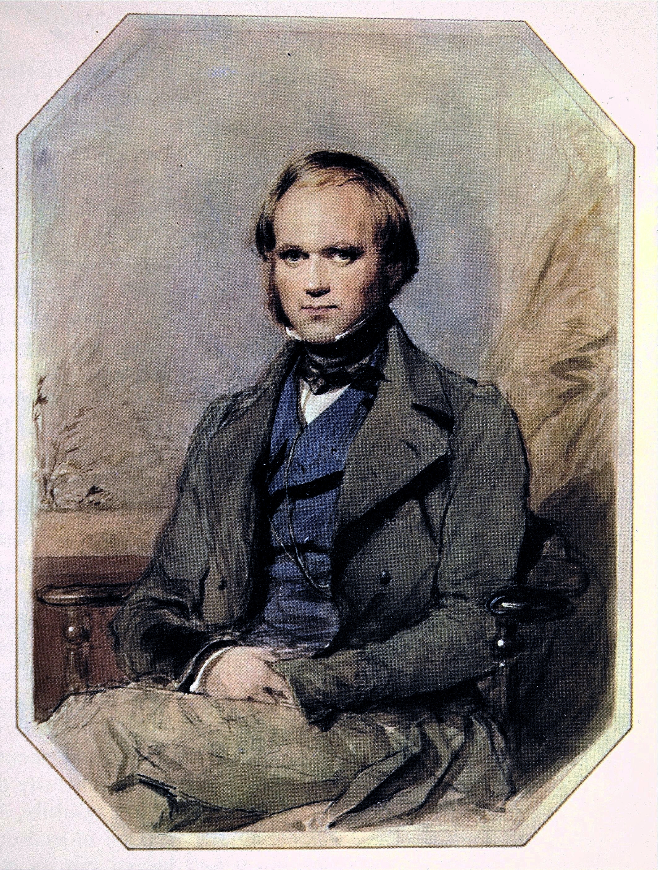
| | | | Most images we have of Darwin show him as an elderly man, with the large white beard he grew later in life after he'd become world famous. Typical is this portrait of him from 1881, the year before he died:
https://upload.wikimedia.org/wikipedia/commons/3/3e/Charles_Robert_Darwin_by_John_Collier.jpg
| | | | But we're taking about the Galápagos visit, when he was a young man in his 20s, and it's much more appropriate for our current purposes to picture him as in this watercolor made in the late 1830s, shortly after his voyage. I was delighted when at the Darwin Center in Puerto Ayora I came across a pergola with benches, and seated on one bench was a life-size bronze statue of Darwin that looked much like this portrait. It really is the accurate image to keep in mind of Darwin in the Galápagos. | | | | | | Darwin was in the Galápagos in 1835. His age-exact contemporary Abraham Lincoln served as a member of the Illinois House of Representatives from 1834-1842. They were both in their mid-20s. |
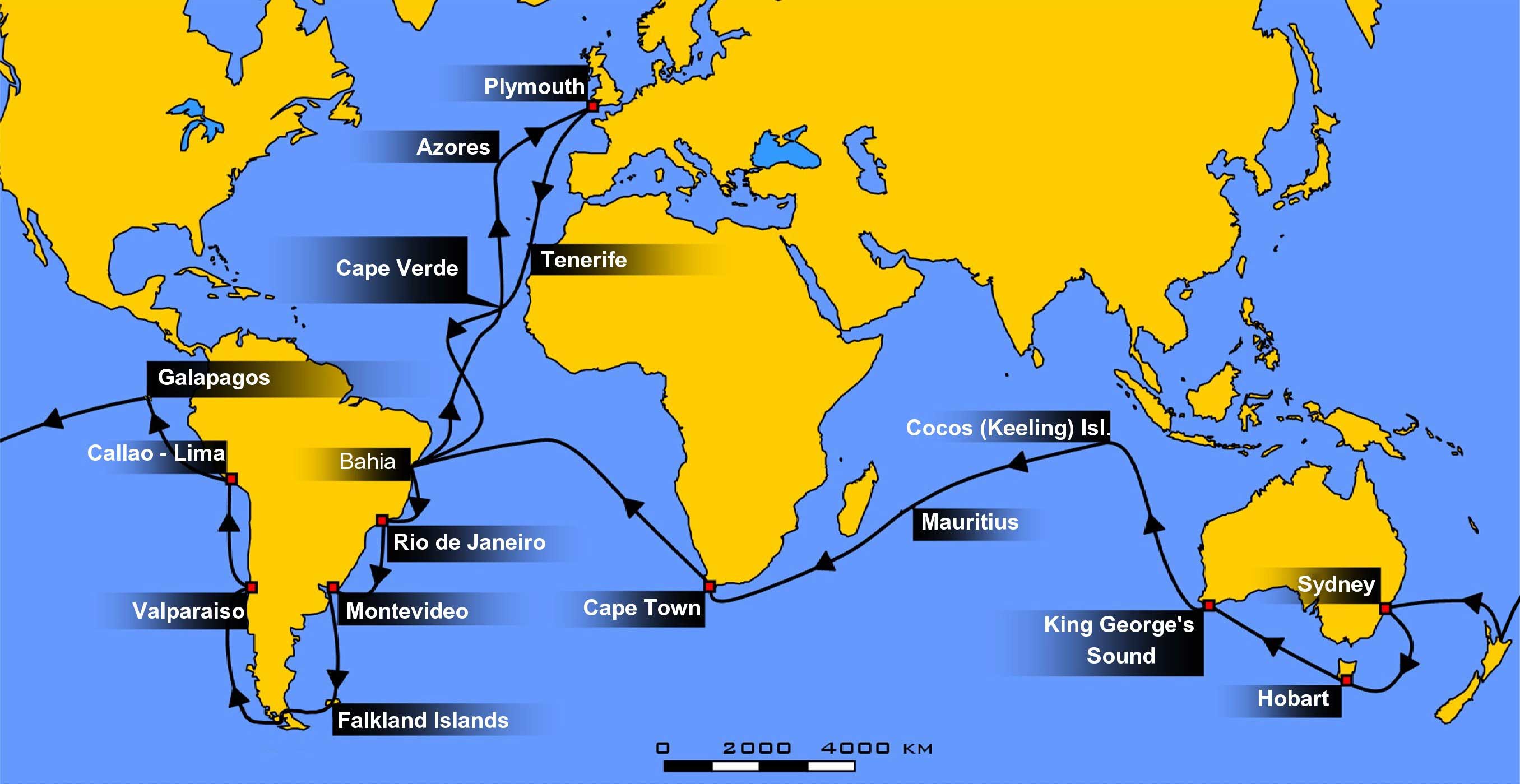
| | | | This map shows the round-the-world route of the famous Second Voyage of the Beagle (Map by WEBMASTER at the German language Wikipedia). It first encircled familiar territory, lower South America. Then from Callao, the port for Lima, it left for the Galápagos. After that, it went on to Tahiti (not shown), then to New Zealand and the south coast of Australia before passing Cape Town on the way home, where it docked in Falmouth. | | | | It was on the east coast of South America that Darwin first experienced a tropical climate, and became interested in the local fauna, so he started collecting specimens of birds and small mammals. He had learned how to preserve bird specimens at the University of Edinburgh, which served him well in his increasing interest in this area. But he had no expertise in it, and still concentrated mainly on geology. He experienced an earthquake in Chile and saw signs that the land had been raised considerably, since high in the Andes he saw seashells and some fossil trees that had grown on a sand beach. | | | | But before he continued on to Australia and beyond, it was his experience in the Galápagos that the world remembers, and we'll discuss that separately in the next posting. But we can at this point show the illustration of HMS Beagle that appeared in Darwin's The Voyage of the Beagle that he wrote after his voyage. It shows the ship in the Strait of Magellan presumably the time he was on it. The ship's statistics are: Length 27.5 m (90.3 ft); Beam: 7.5 m (24.5 ft); Draft 3.8 m (12.5 ft). | | | | The THIRD VOYAGE of the Beagle ran from 1837-1843, when it the ship was commissioned to survey large parts of the still uncharted Australian coast. Neither Darwin nor FitzRoy was aboard this trip, but those in charge had been on previous expeditions: John Clements Wickham had been on the Second Voyage, and John Lort Stokes (no relation to the suicide), had been on both previous voyages. Like the First Voyage, it had two phases, since Wickham resigned due to ill health at which point Stokes, who had shared a cabin with Darwin earlier, took over. | | | | Their mission was specific, to chart the coasts of Australia, but I've not been able to find any maps of the voyage. But if you look back to the map of the Second Voyage, I can say that I do know they started out by stopping in Tenerife and Bahia (in Brazil, like on the Second Voyage), but then went over to Cape Town arrived in Western Australia, so I have to assume they returned by the same route. | | | | This is the map of Australia (click) that Stokes published afterward. The coastal areas in red are the areas they surveyed. They started on arrival at Swan River (today's Perth) and worked well up the west coast to the FitzRoy River. They then moved down to the Bass Strait and Tasmania (formerly Van Diemens Land) and then worked the north coast. | | | | Both Wickham, and later Stokes, named numerous places after eminent people and members of the crew (see Fitzroy River above). But do not miss Darwin. Look at the north coast, left of center, where the red area includes the notation "Port Darwin" on an angle pointing to the lower right. Wickham named Port Darwin, which was first sighted by Stokes, in honor of their former shipmate. A settlement there became the town of Palmerston in 1869, but then the settlement was renamed Darwin in 1911 (2010/20). During the survey the Beagle Gulf was named, the second stretch of water named after the ship. It's here unnamed on the map, but it stretches northwest from the town of Darwin. | | | | The HMS Beagle made no more expeditions. She was decommissioned in 1845, stripped of her masts, and moored in the River Roach in the Essex marshes on the north side of the Thames estuary for use by the Coast Guard as a watch station against smugglers. She even lost her name, being renamed Watch Vessel 7 in 1863. The end came in 1870, when she was sold and broken up for scrap. Some of her timbers may still lie in or near the Thames estuary. She was born on the Thames, and is apparently buried there. Sic transit. | | | | The Beagle et Moi Only as I've been writing this have a realized something that truly surprised me, but I suppose I should have expected it, as it's an unavoidable result of extensive travel. I have been in many places around the world the Beagle has been to: Plymouth Harbour (on the Deutschland), the Azores, Tenerife; on the Caronia around South America (but in the opposite direction): Bahia, Rio, Montevideo, the Falklands, Beagle Channel, Strait of Magellan, Valparaiso, Callao/Lima; as of now, also the Galápagos; Tahiti, Auckland, Sydney, Hobart, Cape Town
Third Voyage only: Perth, Bass Strait, Darwin
| | | | | | I just mentioned the Deutschland, which I've described as perhaps my favorite ship. I've been on it four times, most recently on the Greenland trip. I recently learned it was sold to an American company who will use it as a floating university for the Semester at Sea program. After a refitting with new painting and new cabins, it will be renamed World Odyssey. Once again I must say: Sic transit gloria mundi. |
| | | |
| |
|
|
|

