|
Reflections 2015
Series 13
July 27
Galápagos IV – The Visit II
| | Once again we'll provide below our maps for reference, first of the Galápagos, then of Santa Cruz, then of Puerto Ayora. Copy and paste them either now or later, when needed:
http://upload.wikimedia.org/wikipedia/commons/thumb/4/4a/Galapagos_Islands_topographic_map-en.svg/2000px-Galapagos_Islands_topographic_map-en.svg.png
http://www.achim-und-kai.de/kai/gal/k_sta_cruz.jpg
http://iau313ecuador.epn.edu.ec/images/mapa2.gif
| | | | We are in the midst of describing the seven-night visit. In the last posting we discussed:
(1) an arrival day at Baltra, which included a half-day Santa Cruz visit: the tortoise reserve, a lava tunnel, and the Darwin Center;
(2) a Beach-and-Bay day--I wasn't eager about the beach visit in the morning, and ended up cancelling it, but the boat tour, the half-day Academy Bay visit in the afternoon looked, and was, quite good;
| | | | The Visit II We will continue here with the rest of the stay in the Galápagos:
(3) three full-day boat trips by yacht: a day trip to South Plaza (good!), a day trip to North Seymour (great!), and potentially a day trip to Santa Fe, which was not attracting me as being nothing special, and then there were problems, so I ended up cancelling it;
(4) two free days, which became three free days with the cancellation, so I used half the middle one for my own morning stroll to the Darwin Center;
(5) a departure day from Baltra, which included what was clumsily billed as a stop at a coffee plantation, which turned out to be a highlight. I'm instead describing it as a morning visit to an artisan coffee farm, a description that does it more justice.
| | | | A Day Trip to South Plaza While the half day in the Bay on Sunday, my second day in the islands, was an excellent introduction to wildlife, and I'd seen at least one of just about everything I'd wanted to see, I was looking forward to the full-day island trips, which did turn out to be adventures. The night before, the reception desk handed me a slip of paper saying what time to be in the outdoor lobby Monday morning for pickup to go to South Plaza, and the bus was right on time. | | | | As great as the day was, there was still that irritating (to me, anyway) lack of explaining what was going on. Where would you have expected the bus would take the people it picked up from various hotels? Well, I thought we'd just drive down Darwin to the malecón and board there, in town, in the Bay. And I was wrong. After picking everyone up, including the captain at his house (!!!) we drove and drove, way out of town. I had no idea where we were going. My mind was trying to fill in the blanks. As the Santa Cruz map above shows, Puerto Ayora is at the 5 o'clock position, and the Plaza Islands at 2 o'clock. If we weren't going to sail between them, maybe we were taking some side road shown in dots? We finally got out at a docking area and, even with my good sense of direction, I was totally disoriented. I went up to the guide, whose name was Adolfo, and who turned out to be one the most pleasant things that happened to me in the Galápagos and asked just where we were. He took me a couple of steps to the left, and I saw the Baltra ferry steps away. We'd taken the 42 km (26 mi) main road back to the Itabaca Channel, and I felt totally foolish for not having realized where we were. | | | | Then Adolfo led us a few steps away to the bag of orange life jackets where we put one on, then stepped gingerly onto and over the prow of the panga nosing into the dock, pushed by its outboard motor. Still, each of us needed to be helped with the clumsy entry. We then rode away from the dock for 1-2 minutes to board our yate (YA.té), or yacht, where we took off the life jackets. The yacht was named the Santa Fe III and I was on it for both island trips, so I feel I got to know it rather well. Copy and paste:
http://www.santafegalapagos.com.ec/bgimg/yacht.png
| | | | The panga let us off at the stern. Fortunately, whenever it was here you got off or on over the side of the panga, which made it much easier. Once you took your life jacket off, you sat down and took your shoes off and put them on a rack. This yacht is "barefoot city", which is typical of Galápagos cruises. | | | | Through Spanish I finally learned to understand a term in English. I heard the captain, referring to the stern of the yacht, using the term la popa. Aha! That deck at the stern was the poop deck, a nautical term I'd heard, never knowing just what it referred to. I've since checked to find out that old sailing ships also had a poop cabin in the stern, and the roof of the poop cabin (none here, of course) was the poop deck. It's also called the easier-to-understand stern deck. | | | | Follow the above picture to find three outside and three inside locations on the Santa Fe III. Stepping in from the open poop deck you enter a large lounge, whose windows you can see in the picture. It had a long dining table with bench seating on the right, and a short one on the left, short to allow for the bar and tiny galley in the far corner, where our hot lunches were prepared. You then go up a few steps to the room that's a combination of a second lounge toward the back, and the "bridge" for the captain up front—you can see the door this side of the captain. To the side of where the captain sat was a spiral staircase going below, where there were two full-size cabins (portholes visible) each with a king-size bed and toilet. We only went below to use the toilets. Ok, heads. | | | | The second and third outside locations are reached by the doors on either side of the captain. You can sit or lounge about up front where the people are, or climb those hard-to-see steps aft of the door to the spacious upper deck, with a large table and benches under the canopy. | | | | The company describes the Santa Fe as medium-sized, with a length of 15.83 m (51.94 ft) and width of 4.75 m (15.58 ft). It has a capacity of 20 passengers, although our group was about 15, plus four crew members and two naturalist-guides, though Adolfo was the only one this trip. | | | | We settled in, and, to his credit, Adolfo did announce our day. We'd stop for snorkeling first, then visit South Plaza, then have lunch on board, and then sail all the way back down to Puerto Ayora. It was good to know what's going on. | | | | Well, sort of. We moved on for a short while, then stopped for snorkeling in an unknown location. Was it some islet? Was it on the back side of South Plaza? On Santa Cruz? After the fact I had to research where the standard snorkeling stop is when going to South Plaza. Look at the map of Santa Cruz, and you'll find Punta Carrión at the east end of the Itabaca Channel, really not all that far from the ferry landing. I suspect its pointed location has currents that attract more fish than usual to make snorkelers happy. | | | | We stopped, and I was surprised that as many as three-quarters of the passengers went snorkeling. I suspect that that's because we weren't a random sampling, but included passengers who had paid more attention to the come-on that snorkeling would be available. The rest of us wasted our time and money sitting around while the snorkelers did their thing. Several of us gathered on the roof deck under the awning, and actually had some rather good conversations, which made the stop more worthwhile. One man was an American who, with his snorkeling Canadian wife, had been living in Australia for the past forty years. From him I got some information that proved what I'd been saying about the Galápagos, that ya can't get there from here. They'd flown from Sydney to Auckland to Santiago de Chile, to Guayaquil to Baltra, four flights that would have involved 3-4 planes, and had that routing in reverse waiting for them to go home. You can see why I would have had trouble trying to include the Galápagos in my South Sea islands trip. | | | | | | In retrospect, I wish I'd asked him one other question. I've been pointing out that Rapa Nui/Easter Island is far less isolated than you'd think, since, when I was at the airport there to fly back to Santiago, I saw planes leaving for Auckland and possibly Sydney. I wish I'd asked him if his Auckland-Santiago flight had also stopped in Rapa Nui/Easter Island. If it had, it would have been another leg on their journey, but would also have made an emotional connection for me between this trip and that one. |
| | | | The other person I had a long conversation with on the top deck was the "guy from Atlanta" that I've been mentioning. Here is where he told me, among other things: that he'd been to Bartolomé, but hadn't seen any of the penguins some people have seen there; that he'd flown in earlier that arrival morning Saturday than I had and didn't get caught in the tropical storm; that they didn't have boots to fit him because of his large size. He and his snorkeling wife were on their honeymoon, but I thought to myself that a Galápagos trip is rather arduous for something like that. To each his own. | | | | When everyone was back on board, he headed for the Plaza Islands, about 20-25 minutes further. This is where we had a high point of the day, described in an earlier posting. Look again at the yacht. Right outside that portside door you see, just above our heads, almost reachable but not quite, there flew a magnificent frigatebird, male, but with his red pouch uninflated. His wings did not move as he rode the air currents that the moving yacht was making. He stayed with us, just hovering there, most of the way to the island. | | | | You can check again on the map where the Plaza Islands / Islas Plaza are located, at about the 2 o'clock position off Santa Cruz. There are two small islands that look like parentheses lying on their side, and we pulled into the channel between them:
http://1.bp.blogspot.com/-BeI652ZgYhg/TVgN6vZkiJI/AAAAAAAAACc/uyd8AgwVbIg/s1600/Mapa%2BPlazas.png
| | | | You'll recall that we said that Leónidas Plaza had served two separate terms as President of Ecuador in the early 20C. While North Plaza Island / Isla Plaza Norte may not be visited, it's easily spotted across the central channel. It's South Plaza Island / Isla Plaza Sur that one visits here. It occurs to me—but is in no way confirmed—that these two islands may have once been joined, or indeed might even have been an atoll, like Bora Bora, but that could also just be my imagination. | | | | There was a dry landing at a dock, very reminiscent of that first dock on the harbor cruise, and which was also surrounded by sea lions, so I suppose we can consider this calm channel another lobería, one that has an estimated 1,000 individuals. We were told there were bull sea lions nearby that kept an eye on their harems. We also were told to avoid the eastern end of the island (see map) described as an area for bachelor sea lions, as there might be danger. Actually, there were white-tipped stakes, the same that we'd seen in the tortoise reserve, that indicated the walking paths to stay within, that also temporarily blocked any entry to the east end. | | | | You can see on the map that South Plaza slopes upward, and that the south end consists of bluffs. Our walk was L-shaped, up to the bluffs, then turning left along them, and back the same way. Aside from the sea lions, we saw the usual land and marine iguanas as we were going up the slope, and numerous birds nesting in the bluffs below us, which also used the updraft coming up the cliffs for soaring. This is where we saw the warbler finch that warbled for us. | | | | | | 2015/11 was where the wildlife was discussed and has pictures of sea lions, the warbler finch, and a video of magnificent frigatebirds flying off the bluffs on the south side of South Plaza. It also has a video of a land iguana on South Plaza. I'll copy that same video again, this time for viewing the terrain as well as the land iguana: "This 3:15 YouTube video shows the arid cactus-filled landscape of South Plaza where the land iguana is found. They live here in underground burrows." |
| | | | We've been emphasizing fauna in the Galápagos with little mention of the flora beyond the lush mangroves in the moister seaside regions, and the croton. South Plaza is known for unusual flora, but again, it's flora that grows in arid, desert-like conditions. Look at these two pictures:
https://upload.wikimedia.org/wikipedia/commons/0/06/SouthPlazaPanorama444.jpg
https://galapagoslastminute.files.wordpress.com/2010/05/plaza-sur-looking-to-plaza-norte-santa-cuz.jpg
| | | | The first one is a fantastic panorama of a huge swath of South Plaza. Click and start panning from the left, with the view due west over to Santa Cruz, including la Parte Alta / the Highlands. Then we see two areas of the bluffs on the south side of the island that house bird-nesting areas. From the foreground, follow the gray path, noting the white-topped stakes indicating the path's limits, past the group of people to the bluffs in the distance. Downhill to the right of those people is the landing area on the north shore, and a boat out in the channel. Behind the boat, distinguish between Santa Cruz and the west end of North Plaza, then continue panning the entirety of North Plaza to its east end. To its right is something I spotted at the time and asked about, and Adolfo told me those were Gordon Rocks / Rocas Gordon (see Santa Cruz map), a scuba-diving area. As to the flora, there is massive purple ground cover, and at the far end of the path, cactus. It's truly an arid landscape, corresponding to the above video of the land iguana. But wait. In the video (take another peek), the land cover was green, as it was when I was there. How could that be? | | | | The second online picture was taken much, much closer to the primitive dry landing area, which some people can be seen standing on (click). Behind them again is the western end of North Plaza, and behind the ship—this one is outside of the channel—is the "mainland" of Santa Cruz. Above the ship is a bird, and, relying on my newly-acquired expertise (hah!), I'll guess by the large wingspan it's a magnificent frigatebird. The people in the foreground are carefully staying within the white-tipped stakes next to the path and are again surrounded by purple ground cover, but now we can see that the cactus is very tree-like, and even has bark on its surface, or something very close to bark. | | | | I had no expertise (hah again!) in local fauna at the time, but have since researched what we saw. The ground cover is called sesuvium. I've never paid any attention in the past to scientific names in Latin, but find myself gradually starting to do so now, sometimes finding doing so quite useful, so sesuvium is Sesuvium edmonstonei. But much more fun than either name is the alternate name in English, Galápagos Carpet Weed, and it seems that "carpet" covers the idea of it being a ground cover. Sesuvium is a genus with eight different species (yay, Darwin!) and is endemic to (only found on) the Galápagos islands. Still, as a lay traveler and not a scientist, I'm happy seeing one species, and will allow botanists to island-hop to find the others if they wish. | | | | Now to the matter of color. Sesuvium is intense green in the rainy season, but turns purple (also red-orange) in the dry season. We've seen purple sesuvium, now let's look at green sesuvium, and also this detail of sesuvium blooming in May (Both photos by Peter coxhead). Now I was there in May, and yes, this IS what I saw, and then I found the most remarkable coincidence. It's incredible what pictures are available on the internet. Both these pictures were labeled online as having been taken on South Plaza at the end of the rainy season, specifically on 21 May 2015. I checked my travel diary for dates, and found that I was on South Plaza three days earlier, on 18 May 2015, and this is just what I remember seeing. You can't make this stuff up.
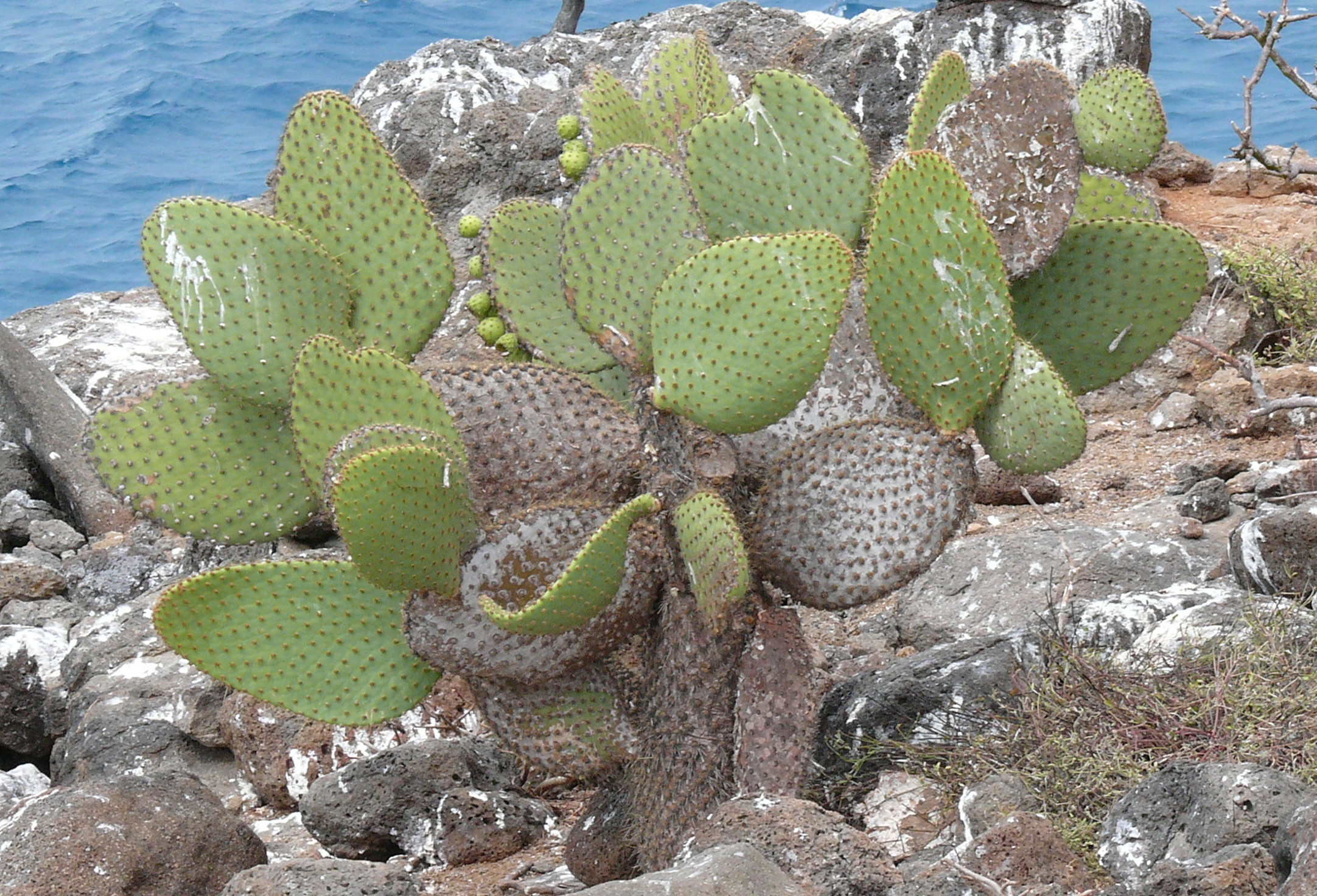
| | | | Now we come to the cactus, known as opuntia, a genus of the cactus family native only to the Americas. It's commonly called prickly pear, although another species of the genus, Opuntia ficus-indica, is the one that's the most common culinary source of prickly pear fruits, called tunas (Photo by Seweryn Olkowicz). I remember eating one on the street in Mexico City, bought from and peeled by a street vendor. | | | | In the Galápagos, though, there are six other species of opuntia. They, too, produce prickly pear fruit, because when asked, Adolfo the guide said locals don't eat the fruit from local cacti, which are protected. For the sake of completion, these are the six opuntia species that appear in the Galápagos: O. echios, O. galapageia, O. helleri, O. insularis, O. saxicola, O. megasperma. But these six species are divided into 14 different varieties, most of which are confined to one or only a few islands. | | | | The term adaptive radiation is used for situations such as with Darwin's finches, which developed different beak shapes according to local feeding habits. Moving from fauna to flora, opuntia are also considered to be excellent examples of adaptive radiation for this reason: roughly speaking, islands with tall tree-like varieties of opuntia, with trunks, have historically had giant tortoises who munched away at low-level cactus arms, and islands lacking tortoises tend to have low, flat, ground-cover types of opuntia. | | | | Once home, I painstakingly checked out all six species online. The last five listed above are found on islands I didn't visit, so I believe I encountered Opuntia echios. But there are five varieties of this species, each with a different appearance and distribution. Two varieties are again located on places I didn't visit, but I believe I must have encountered all three other varieties. I'm pleased that I did this, not as Darwin, not as a botanist or scientist in any way, but as a lay traveler who didn't know what he was doing, but had figured it out anyway. Without necessarily realizing at the time that they were different from each other, I would have encountered:
Opuntia echios var. echios on South Plaza, Santa Cruz, Baltra
Opuntia echios var. gigantea near Academy Bay on Santa Cruz
Opuntia echios var. zacana on North Seymour
| | | | So here we still are on South Plaza on Monday. As in the above pictures, we're looking at Opuntia echios var. echios (Photo by Vince Smith). Click to inspect both the tree-like bark, and to find a few of the fruits growing off of an occasional pad. Friday, when we're on North Seymour, we apparently will be seeing Opuntia echios var. zacana (Photo by Haplochromis), a much shorter variety, hugging the ground. Note here, too, the two pads with fruit. | | | | So we get back on board the Santa Fe III for our return, but before we go very far, we swing south of South Plaza to look at the bluffs from water level (Photo by Pete). We then have a ride of an hour or so back to Puerto Ayora, the longest ride we had in the islands. I wandered to all parts of the ship, and as we were moving at a good clip, had to hold on tightly everywhere, particularly outside. But as I was back inside, maneuvering down the few steps from the upper to lower lounge, the ride suddenly became rough, and the boat lurched violently to one side. I must have been between handholds, because I slammed into the corner of a table, hitting my left hip. Nothing happened, it didn't hurt, but when I got back to the hotel, I found I had a bruise on my hip the size of a saucer. This follows the bruise on my left shin when the board collapsed under me near the dock on the harbor cruise. Neither hurt, neither was a problem, both healed promptly, but I must say, this is the first time I remember coming home from a trip of any sort with not one, but two "war wounds". | | | | I had a long talk with Adolfo on the ride back, wondering why the ports keep changing, and the answer was so simple: repositioning. The boat was in the north yesterday, so this morning we took the bus to get it. The boat is needed in town tomorrow, so we're returning to Puerto Ayora now. Easy when you know it, but why can't they tell you in the first place? And Adolfo is one of the good guys! | | | | I told him about my problem with the second of my day trips, potentially to Santa Fe island the next morning, plus my trip Friday to North Seymour. That's when he told me that not only the Santa Fe III was going to those places then, but so would he! Santa Fe Island still didn't attract me, since it seemed to just be more iguanas and not much else, but if it were this boat and this guide, I'd be willing to put up with watching the snorkelers another day. So we'd see what happens. | | | | We then pulled into Academy Bay—it was a good feeling to be "back home"--and our panga brought us to the malecón. Again I had the walk just about the length of Darwin to the hotel, but this time decided to dine closer to downtown, at one of the two restaurants I liked there. I chose Il Giardino, which included Italian specialties. It was here that the menu showed a picture of, and explained about, locro de papas that we talked about in 2015/11, the potato soup with a quarter avocado in it. We decided in that posting to call locro de papas (Photo by Emilio Mondragón) just potato locro. I followed it with gnocchi, and used the coupon the tour company had given me for a free ice cream for dessert. | | | | But what ended up happening on Tuesday was quite different. When I asked Ricardo on arrival at the airport about the unclarity of what was going to happen, he just brushed off the question. Then Monday evening, coming back from Il Giardino, there was still no slip of paper at the reception desk with the morning pickup time, which presumably hadn't been delivered yet. I went to the room, and after a while, there was a banging at the door, not a knocking, but a banging. When I answered the door, who was there but Ricardo, for some reason handing me the slip of paper in person. He was less eager to see me than I was to see him. But when I read the slip, it said it was a trip to Santa Fe Island in the morning, then, after lunch onboard, the afternoon was to be spent at Playa Escondida ("Hidden Beach"). I didn't mind watching snorkelers on an island I didn't want to see, but had no intention of spending an entire afternoon in the blazing sun at some beach. I told Ricardo that, in our usual Spanish, but he said that's just how it was. He left, and I was fuming. After a while, I went to the reception desk, which apparently is in communication with the tour company, and told her to let them know I'm not going, and to cancel the day trip. (Friday, when I did see Adolfo again and told him about it, said that the trip I was being offered, with the beach, was from another company on a much smaller boat. He didn't seem too impressed, either.) | | | | I went to the laptop and emailed Jim McDaniel at Amazon Adventures about the cancellation. I'd considered the whole week as a package, and rather than considering it a financial loss, I just said I felt I wasn't using part of the package. Still, I asked him to see if he could get a refund for the day trip, which he said he'd do. | | | | So Tuesday morning after breakfast I passed up the trip. After a while, there was another knocking—politely—at my door. It was the guy from reception with a phone in his hand. A woman from the tour company, speaking English, said last-minute refunds aren't possible, since the trip was already paid for. Fine, I told her, let it be. Then a very nice thing happened. When I emailed Jim about no refund being given, he said that if I did arrange with him to go to Peru and Bolivia next year, he'd give me his own credit at that point. Just the offer alone is a very gentlemanly thing to do and is actually more significant to me then getting back the money. | | | | So Tuesday became the first of three days at leisure, instead of the planned two. I wrote during the day in the room and in the garden. In the late afternoon's cool air, completely relaxed, I walked into the center of town and for the first time, had time to visit Fisherman's Wharf and wander on the boardwalk among the mangroves filled with brown pelicans. This was the day I discovered the Pelican View Restaurant one flight up, with my nice balcony view over the bay and pelicans. One thing I had was a nice crema de zapallo / cream of squash soup. I took advantage of the all-evening happy hour with a second free cocktail, then floated home. | | | | A Morning Stroll to the Darwin Center The middle free day was Wednesday. I decided to cushion the only day I was actually doing a project entirely on my own by the two other free days, so it was then that I decided I'd walk over to the Darwin Center to see it better than during the tropical storm last Saturday. But still, the weather didn't cooperate. I assumed by leaving in the morning right after breakfast I could avoid some of the heat, but that was erroneous thinking. I started feeling the heat walking the two blocks down to Darwin (see town map), and by the cemetery, I knew it would be a difficult visit. Then there's that long entry walk. No puddles this time, but any time a tree gave some shade, or a bench some respite from the heat, I took advantage of it. | | | | As usual, a huge meter/yard-long black marine iguana (Photo by David Adam Kess) had wandered up from the adjacent beach and was sitting on the sidewalk in the shade. I stopped, as usual. It's always worth having a look, even after your gazillionth iguana, which I think this very well might have been. I asked (in Spanish) for a map at the information booth. Not only didn't they have any, but the map on a nearby sign was unintelligible—and I'm good with maps. So, I just continued straight to the far end, and got a very nice surprise. At the end of the walkway, I stepped into a three-sided gazebo with benches and found to my delight that Charles Darwin was sitting on the bench to my right.
http://galapagosconservation.org.uk/wp-content/uploads/2014/09/10441401_728836540502841_211607161501593059_n.jpg
http://i2.wp.com/www.inkedadventurer.com/wp-content/uploads/2014/12/20141222_070955.jpg?resize=242%2C322
| | | | It was a beautiful bronze statue of Charles Darwin as a young man. This was appropriate, as opposed to all the bearded statues and pictures you see of him in his later years, since he was only 26 when he was here in 1835. It was a little harder to find online pictures of the statue, and I found out why. Later research showed that it was only installed last September, eight months before I saw it. Therefore, the first picture above is the only one that decently shows the statue, despite the fact that it also shows workmen still installing it in the gazebo. It's a very intellectual, studious pose with a book, which is also very appropriate. The workman in the back is preparing the bench for the statue, and the person sitting on the right is where I sat down to find I was in a tête-à-tête with Darwin. The second picture is a much poorer picture of the statue in situ on the bench. | | | | To an extent, this statue now being here belies what I said about there being nothing of Darwin to see in the Galápagos, such as house, since he camped out. It was a pleasure for just the two of us to be sitting in the gazebo communing with nature, despite the heat. Then of course, some tourists arrived and a couple of them sat on either side of the statue to have their egotistic picture taken, interrupting our atmosphere. Oh, well. | | | | Ecological Conservation The official name of the Darwin Center is the Estación Cientifica Charles Darwin (Photo by TriiipleThreat), or Charles Darwin Scientific Station, but is rendered in English as the Charles Darwin Research Station, or CDRS. I personally don't think either version is as good as "Darwin Center". It's run by the international non-profit Charles Darwin Foundation, and the headquarters of the National Park are also located here along with the offices of the Galápagos National Park Service, or GNPS. Both organizations work together in restoring the ecology of the islands. This is done in two logical ways, one involving subtraction and the other addition.
| | | | The one involving subtraction is the attempt to eliminate introduced predators. Feral dogs and cats kill tortoise young and both young and adult iguanas. Feral goats and pigs vie for the vegetation that native wildlife requires. For instance, in 1975, two populations of iguanas, one on Isabela and one on Santa Cruz, were decimated in less than six months by feral dog attacks. Saving the iguanas required eliminating the dogs. These eliminations are ongoing, and I have examples of two. Some years ago, seven goats were exterminated from South Plaza. We saw how small that island is, and can imagine how the goats reduced vegetation the iguanas required. Another example is on Santiago/San Salvador Island. Pigs and goats had been introduced by humans and had done much damage to the endemic species. Pigs were eradicated there by 2002, and goats by the end of 2006. Other introduced species they are trying to eliminate are rats and red ants. | | | | The addition side involves selective breeding. More famous is the tortoise breeding at the Darwin Center, but also important is the iguana breeding center. Following the two above wild dog incidents in 1975, in 1976 the Center began an iguana breeding program. My current information is that iguana repatriation to the problem area of Isabela was unsuccessful, since the location still has wild dogs, although iguana patriation to the problem area of Santa Cruz seems to have been successful, since the dogs had been eliminated. | | | | We spoke earlier about the private iguana conservation efforts of Allan Hancock in the 1930s, where he brought 70 endangered iguanas from Baltra to North Seymour, where he noted none had been, despite the short distance between the islands. They thrived there, and an iguana breeding program is ongoing on North Seymour, and iguanas have been brought back to Baltra. Among the pens surrounded by stone walls at the Darwin Center I found at least one containing iguanas (Photo by David Adam Kess). | | | | But of course it's the giant tortoise breeding centerat the CDRS that's most famous. The program is conducted by the GNPS staff in collaboration of CDRS scientists. Tortoise eggs are brought in from various islands, incubated, then reared until they are five years old. This is an egg and hatchling (Photo by flickr.com/photos/akeg). At five years, juveniles can survive the introduced predators such as rats, pigs, and dogs and are then re-introduced to their native areas, each species to its proper island. Since 1970, over 2000 have been reintroduced, and over 400 are being raised at the Center. | | | | The success of the program can be illustrated by Española Island. In 1971, the entire population of tortoises on Española was 14, two males, and 12 females, and it was feared that such a low population across the island would result in no mating in the wild. All 14 were brought to the Center for the captive breeding program and a third male was brought in from the San Diego Zoo in the US. The program was so successful that, as of 2008, more than 1,500 juveniles have been returned to Española, which is now free of introduced predators, since goats were eradicated in 1978. Because the island is now so safe, the tortoises are returned at age 18 months instead of waiting for to be five years of age. Over time, tortoises there have begun to again reproduce naturally, but to do this elsewhere requires a lot of effort and money. Still, these breeding and release programs have successfully brought most endangered subspecies up to less dangerous levels. As of 2008, more than 4,000 juveniles in total from eight different populations have been repatriated to their island of origin. | | | | Leaving the Darwin statue at the far end of the road, as the map shows, you can loop back and find the area of the tortoise breeding center, which resembles a small zoo with waist-high stone walls forming pens or corrals for the larger animals and smaller, caged enclosures for the juveniles. One of the first things you come across are those juveniles:
http://www.redmangrove.com/blog/wp-content/uploads/2014/06/IMG_6747-1280x853-720x479.jpg
| | | | There are several of these consecutive enclosures in a row, each with a slightly older group, but typical is the soup-bowl size of these tortoises. You can see the numbers on their back, which not only indicate which species they are (and which island they'll go back to), but also identify the individual tortoise. | | | | Everything here is explained on signboards in Spanish and English, so the guide we had that first day was not really necessary. Anyone can visit a zoo on their own and read the signs, right? And this is where I actually first learned something I referred to in an earlier posting. I said the temperature of the tortoise nests determines the sex of the hatchling. Here, it was explained more fully, since the scientists had to know how to set the incubators. These are the numbers: 27.5°C (81.5°F) yields a male, and 29°C (84.2°F) yields a female. It's amazing that such minor changes can make such a major difference. | | | | The bulk of the area has adult tortoises (Photo by Movera) in captivity, in corrals, or pens. Copy and paste this link for another picture I like at the CDRS:
http://2.bp.blogspot.com/-cB4UJxIuPU4/UzQIAIetScI/AAAAAAAADyE/DipWwqwONPw/s1600/IMG_0052.JPG
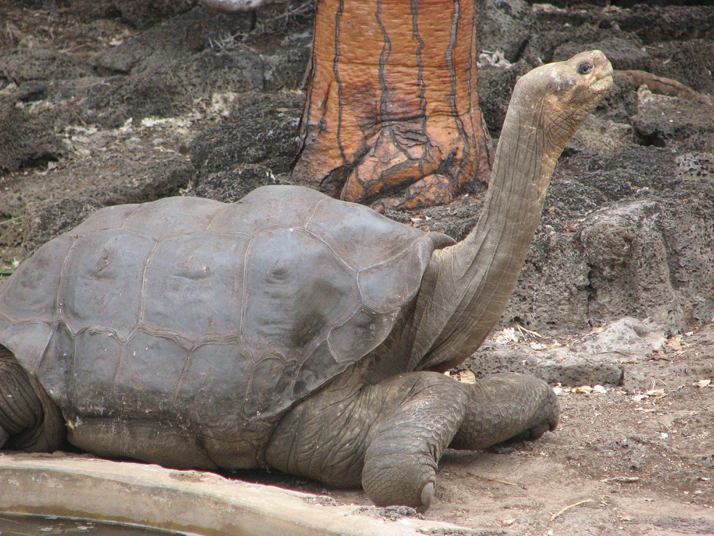
| | | | You may or may not be able to tell that all the tortoises have five front toes, but four back toes. Also note that while human elbows point backward, so that the hands can meet, the front elbows on tortoises point inward, which helps with digging and movement. I also just came across something rather shocking. Up until a few years ago, apparently visitors were allowed to walk into the pens, to "walk among the turtles", just like in the Reserve, but there was too much abuse of the privilege, including inappropriate behavior and littering, and entering pens can no longer can be done. I suppose there's no accounting for some people. | | | | There was a cluster of people looking over the wall at one point, and when I got there, it looked like one Volkswagen Beetle had been driven up onto another, but it wasn't. You guessed it—this is the breeding center, and it was tortoises mating. Coming across such a sight is apparently not uncommon. There are t-shirts in town showing it, and there was an almost-life-size mahogany woodcarving of mating tortoises in the hotel passageway next to the garden. This is an online picture of one pair about to mate (Photo by Minglex), and you can see how typically the male is so much larger than the female. It's also noisy—you can see the male is already starting to grunt. We also have a front view (Photo by davidberkowitz) of another pair. Finally, we have a third pair in this YouTube video (0:47). You can distinctly hear his grunts—this and the warbler finch are the two animal sounds I remember from this trip—and if nothing else holds your attention, you can count front and back toes. | | | | Lonesome George It's hard to think of an individual animal who is famous in its own right. Don't include movie animals like Lassie, which is a character portrayed by many different dogs. You might come up with famous racehorses, and some Presidential dogs—and cats—might come to mind, but it's not common. In this rarefied atmosphere we come to the most famous tortoise in the world—OK, the ONLY famous tortoise in the world—the late Lonesome George. Why should he be famous? Was it some great age? No, at his death, it was estimated that he was just over 100 years old, which is old, but not particularly remarkable for his kind. However, Lonesome George was, for the tortoises of Pinta Island, the last of the Mohicans. | | | | | | James Fenimore Cooper's 1826 novel of that name takes place in the upper New York State wilderness during the French and Indian War. After a massacre, a Mohican named Uncas, son of chief Chingachgook, remains as the last of his tribe. While Cooper also made reference to the Hurons, an actual Iroquoian tribe in the area, he made up the fictitious tribal name Mohican, since no real tribe had ever been wiped out in that manner. To do so, Cooper, either wittingly or unwittingly, blended the names of the Mahicans of the Hudson Valley and Mohegans of Connecticut. The name of the novel has become proverbial, not only in English, but internationally, to refer to the last survivor of a group. I can confirm this with examples for German (der letzte Mohikaner) and Spanish (el último de los mohicanos), and it's probably true in quite a few others. |
| | | | Look at the map of all the Galápagos islands and find, among the cluster of three to the north, Pinta Island, once known as Abingdon (misspelled on the map). This had been the location for the tortoise species Chelonoidis nigra abingdonii--notice the influence of the English name on the scientific name. But to tell the whole up-and-down story really involves the worst predator of them all, humans. | | | | C. n. abingdonii had last been seen in 1906, after which it was considered extinct, wiped out by human settlers, who overharvested the tortoises for meat, and who also introduced non-native goats and pigs that destroyed the tortoises' habitat and much of the vegetation on Pinta. Then on 1 November 1971, Lonesome George, at the time around 60 years old, was discovered on Pinta, and was believed to be the last of his kind. For that reason, he was considered the rarest creature in the world and became an international symbol for conservation efforts everywhere. He was relocated to the Darwin Center for his own safety, while it was hoped that another Pinta tortoise might be found, if not on Pinta itself, then in a zoo somewhere, just as the Española tortoise had been found at the San Diego zoo. He was penned with two females of a different subspecies, and, while eggs were produced, none hatched. Since no other Pinta tortoises were found, the species was pronounced extinct, even while George was in captivity. | | | | Lonesome George died at the Darwin Center on 24 June 2012. As mentioned, it's estimated that he was born c 1910, making him about 102 years old, but other estimates widen that spread. He might have been born anywhere between 1903 and 1919, which would mean he lived between 93 and 109 years. This is Lonesome George at the Center in December 2006 (Photo by Mike Weston). As with all giant tortoises, his head and neck bear a resemblance to ET the Extraterrestrial. Friend Sue, whose emails about her visit quite a while ago I quoted in the last posting, remembers "petting Galapagos tortoises at the Darwin Station" and "Randy petting George". This would reflect the above statement that visitors used to be allowed into the pens, which is no longer the case. | | | | I was wondering about the official name Fausto Llerena Tortoise Center and wondered who Fausto Llerena was, and why he was honored this way. This is Fausto Llerena with Lonesome George:
http://photos.mongabay.com/12/0629lonesomegeorge01.jpg
| | | | For almost three decades, since 1983, park ranger Fausto Llerena had been the primary keeper of Lonesome George, and he considered George his best friend. Llerena was 72 when, in 2012, he came one Sunday to visit his friend, which he used to do even on his days off, but George didn't come to greet him as usual, and Llerena found George dead in his pen. Because of his devotion to George and to conservation, Fausto Llerena was recognized by the addition of his name to the Centro de Crianza de Tortugas Terrestres Fausto Llerena / Fausto Llerena Tortoise Breeding Center. He is today Ecuador's oldest park ranger, and is addressed respectfully as don Fausto:
http://www.galapagospark.org/sitiosdevisita/centro_crianza_fausto_llerena_foto_03.jpg
| | | | Between the small cages for juveniles and the pens for adults there still is an area dedicated to Lonesome George:
https://familygapyear.files.wordpress.com/2013/02/tortoise-george-rip.jpg
| | | | This sign is typical of the bilingual instructional signs in the Center. However, if you read the last line you'll notice it's out of date. Although he's gone, his pen is still there, as are the two females he lived with from Wolf Volcano, the northernmost volcano on Isabela, right across from Pinta (see map). And within this domestic information of George's lies some additional amazing facts about tortoises. | | | | If it wasn't amazing enough that the sex of the hatchlings is determined by temperature, we can add that tortoises remain sexually active all their lives. But it gets better. Among tortoises, sperm remains viable in the vagina for up to three years. That sentence is worth rereading so that it sinks in. On the basis of these facts, for three years after Lonesome George died, there was hope that he could still have had offspring, which brings us from June 2012 to June 2015. But nothing happened. | | | | | | The hopes of the scientists confuse me. If George was breeding with females of other species, if there had been any offspring, they would have had only have half of George's Pinta DNA. But maybe some was considered better than none. |
| | | | We can finally come to the name. The name was bestowed in English, and there were shops in town named after George. If you wanted to render it into Spanish, as in the above sign, it's El Solitario George, which is of course actually Solitary George, I suppose close enough. But the name is here never Jorge. So where did the name come from? | | | | I looked it up, and when I saw the answer, I gave the proverbial slap to my forehead. Of course! George Gobel! It probably never occurred to me to associate something in the Galápagos with American TV of the 1950s, but that was the answer. In those years, George Gobel was a very funny TV comedian with a self-deprecating sense of humor. Referring to himself, one of his lines was: "Did you ever think the world was a tuxedo and you were a pair of brown shoes?" In any case, rather than referring to himself by his full name, for no apparent reason whatsoever, he called himself Lonesome George, as in ". . . this is Lonesome George wishing you a good night." The term became his catchphrase, was popular in the era, and stayed with him for the rest of his career into the next decades, including when his namesake tortoise was discovered on Pinta. Small world. | | | | But was George really the last Mohican? I just followed up on an online cross-reference and found an article in the National Geographic News dated 17 November 2012, later in the year George died. It describes how researchers from Yale University have found that DNA from George's ancestors lives on, and that more of his kind might still be alive. But they are not on Pinta. They've been found on the northern tip of Isabela at Wolf Volcano. Within a population of 1,667 tortoises they identified 17 hybrid descendants with DNA of C. n. abingdoni, including 3 males, 9 females, and 5 juveniles (under the age of 20). The fact that there are juveniles suggests that purebred specimens may also exist on the island. Since tortoises live for so long, it was felt that even the parents of some of the older individuals may still be alive today, and some may be purebreds. And as we know, tortoises remain sexually active all their lives. | | | | But northern Isabella is some 50 km (30 mi) from Pinta, so how did these purebreds get there in the first place? It's believed that ocean currents had nothing to do with it. Instead, this could be an instance of where human interference, instead of being destructive, might have actually done some good. We said that whaling ships and naval vessels would take live tortoises into their holds for food, since tortoises can survive for long periods of time. But during naval conflicts, the tortoises, which weighed 90-270 kg (200-600 lb) each, were often thrown overboard to lighten the ship's load. Thus they could have ended up on Isabela. | | | | And the story gets even better. Floreana Island was heavily exploited, as we explained in the island history, by visiting ships, and its tortoises are extinct. Their species is either called C. n. nigra or C. elephantopus. But one of the Wolf Volcano specimens contained DNA from this species, as well. It is not impossible that a purebred survivor from that population could still be found here in the future. National Geographic has given an additional grant for researchers to return to the rugged countryside around Wolf Volcano to collect hybrid tortoises, and, if they can find them, purebreds, and begin a captive-breeding program. It could be conceivable that both species are not extinct, but could be restored to the wild on their proper islands. | | | | | | Have you noticed the same quirk as I have about Wolf Volcano? Not only is it mentioned here, but Lonesome George's two "widows" in his former pen at the Center are also from there. Is it a coincidence, or did scientists at the Center feel there was some kinship? I don't know. |
| | | | I slowly worked my way back in the heat from the Center to the hotel, with frequent stops on benches in the shade. I was gone for two hours, 9:15-11:15, but without the heat it would have taken much less. I had to jump into the shower and rinse out my quick-drying shirt before I could spend the rest of the afternoon in the room and garden, writing. In the evening I headed back for dinner at the Pelican View Restaurant, and this time, Hugo saw don Vicente coming from the balcony and waved me upstairs. With dinner, I again tried the free second happy hour cocktail, which really relaxed me for the night. | | | | | | One more comment on the heat. At the end of 2015/9 there is a picture of me taken by Mike Strohmeyer at South Pass Lighthouse. In it I'm wearing a beige, broad-brimmed cap in the cool, but sunny weather. I also wore that cap throughout the Galápagos. I sweated into it so much, requiring frequent rinsing out, that the buckle in the back that held the tightening strap rusted through and through, and into the material. I did keep the cap until the end of the trip in Quito, where it ended up in the wastepaper basket. So much for extensive heat. |
| | | | The third of the three free days was Thursday, which I spent relaxing in the cool hotel garden and writing. I went to the Pelican View for dinner for the third and final time—too much of a good thing—and settled for just a beer with dinner. | | | | A Day Trip to North Seymour The second full-day island trip was to North Seymour / Seymour Norte. You may recall our saying that Lord Hugh Seymour was a Royal Navy Officer in the late 18C. Since that island was well to the north, I suspected it would be a round-trip by bus to Itabaca Channel, and I was right, including picking up the captain at his house going and dropping him off coming home. It was Friday, my last full day in the islands. Adolfo was joined by an older guide, Diego, on this trip, and by now I knew the drill when we reached Itabaca Channel. Life vest on, short panga ride, life vest off, and shoes off and on the shelf on the poop deck of the Santa Fe III. I went upstairs, with others, and spent the 30-40 minute crossing (see Santa Cruz map) on the top deck, at the table under the canopy, where there was a refreshing breeze with which to enjoy the ride. | | | | When we approached North Seymour, we had this view of its westernmost tip (Photo by David Adam Kess). Click to enlarge to inspect Daphne Island on the left (it also appears on the Santa Cruz map). It was between Daphne and us that Adolfo pointed out the frolicking dolphins discussed earlier. When you look at North Seymour on the right, you'll find the typical one-story bluff found on many of these islands, and the typical arid landscape above it. Where the people are standing you can see the beginning of the path, and at least one white-tipped stake delineating its limits.
http://2.bp.blogspot.com/-755-_DMLXe4/TVgBq26gdEI/AAAAAAAAAB8/yPImPN7tauY/s1600/Mapa%2BSeymour.png
| | | | But where we landed was a little to the right of this last picture, at the left-hand landing marked "dry" on this map, which, as you can see, is at the foot of the bluff. Well, a dry landing it was, as usual, but far from an easy one. I could see the problem as we approached, and clearly remember saying to Adolfo "We have to climb THAT?" An extremely primitive few steps ascending the bluff had been jerry-built into the stone, steps that were rocks connected with some concrete. It would have been hard enough to climb, but first you had to maneuver over the prow of the panga (with help, as ever), and hope you landed properly on the bottom step. There was no railing—that would have made a huge difference--and I'm sure that these steps would have been condemned in the US or in any other country with strict safety rules. I'm not usually subject to vertigo, but these steps were the type where you'd rather lean forward and guide yourself with your hands on upcoming steps as you managed your way up. It was not a pleasant experience, and contrasted in particular with what a positive experience North Seymour was otherwise. Let me put it this way: even the photographer who took this picture of the so-called stairs (Photo by Vince Smith) labeled it "Tricky Arrival at North Seymour", an understatement, and the picture was taken only about three-quarters of the way to the top. | | | | Arrival up on the bluff alone gave a feeling of accomplishment, but then a simultaneous feeling of dread—how will I ever get DOWN? I'll quote again what friend Sue said in the last posting about the Galápagos: "It was not an easy trip." I'd add this: if you've never been here, are you sure you want to come? Well, of course you do, and you certainly should, and I'm glad I did. But just be forewarned of these occasional difficulties and don't come with a cavalier attitude of travel in paradise. | | | | Our little island map shows other wildlife, sea lions, and swallow-tailed gulls, both of which I also saw on South Plaza, but we'll concentrate on the two kinds of birds you come to North Plaza to see, plus some interesting flora. And let's not forget the marine and land iguanas, because the land iguanas here (Photo by David Adam Kess) are descended from those saved from Baltra in the 1930s. | | | | | | We have lately gotten more deeply into scientific names in Latin, and that's probably a good thing, as long as we don't go too far with it. Thus, for he sake of complete disclosure, we can now give a small summary. In Guayaquil we saw the green iguana (pictures in 2015/10), typical of those in Mexico, the Caribbean, and Central and northern South America. That genus is Iguana, and the most common species is the green iguana, or Iguana iguana.
The reason the Galápagos iguanas are unique is that they are of another genus, Conolophus, of which there are three species. Two are restricted in area, and one is found more generally in the islands. This latter one is the one we've been seeing, and whose picture is above. It's Conolophus subcristatus, and is known as THE Galápagos land iguana. It's found primarily on Santa Cruz, Baltra, North Seymour, South Plaza, plus two places we haven't visited, Isabela and Fernandina. You can see by their distribution why they have their name.
Limited only to Santa Fe Island (Barrington), is Conolophus pallidus, or the Barrington land iguana (Photo by ConolophusPallidus-Stone.JPG, cropped by Haplochromis). It's similar in every detail to the Galápagos land iguana except for being a paler yellow (hence "pallid" is in their name), and have a longer, more tapered snout and more pronounced dorsal spines. It should be noted that it's been questioned whether this is a valid separate species or merely a variant or subspecies of the previous one.
The other restricted one is Conolophus marthae, called the Galápagos pink land iguana (Photo by Rimini), limited only to the north end of Isabela, specifically to the area around the recently discussed Wolf Volcano. However only about 100 individuals have been identified. It was only discovered in 2009, and is distinguished by its pink color, some dark stripes, but is otherwise minimally different from the Galápagos land iguana.
I will now repeat my earlier assertion, that I'll leave it to the biologists to visit each type of iguana. As a lay traveler, I'm happy to be knee-deep in the main species wherever I go, and do not need to go to Santa Fe (which is just what happened) to find a yellow one, or to northern Isabela to try to find one of the only 100 pink ones. Just knowing intellectually that several species exist gives me all the satisfaction I need on the subject of iguanas.
|
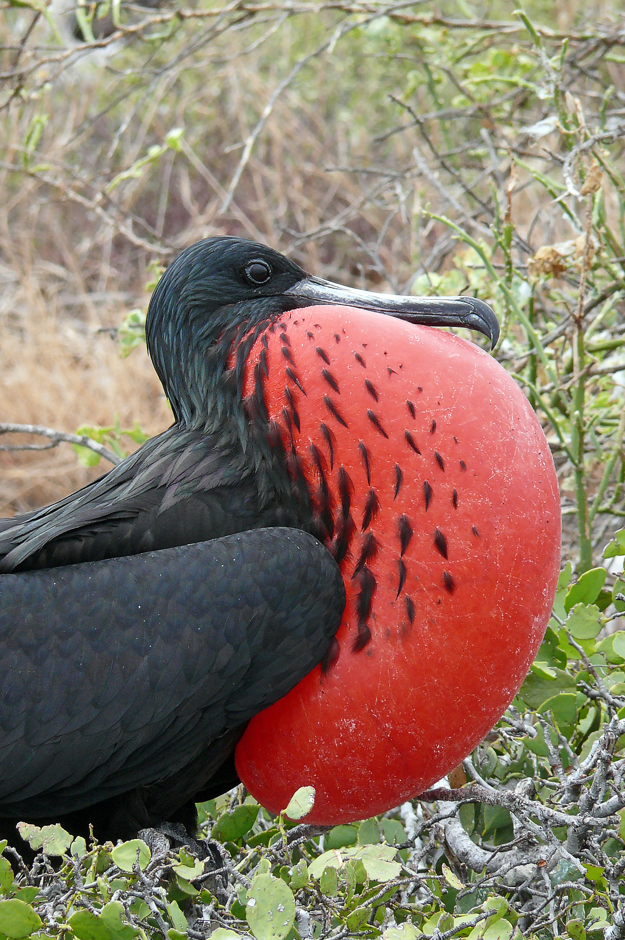
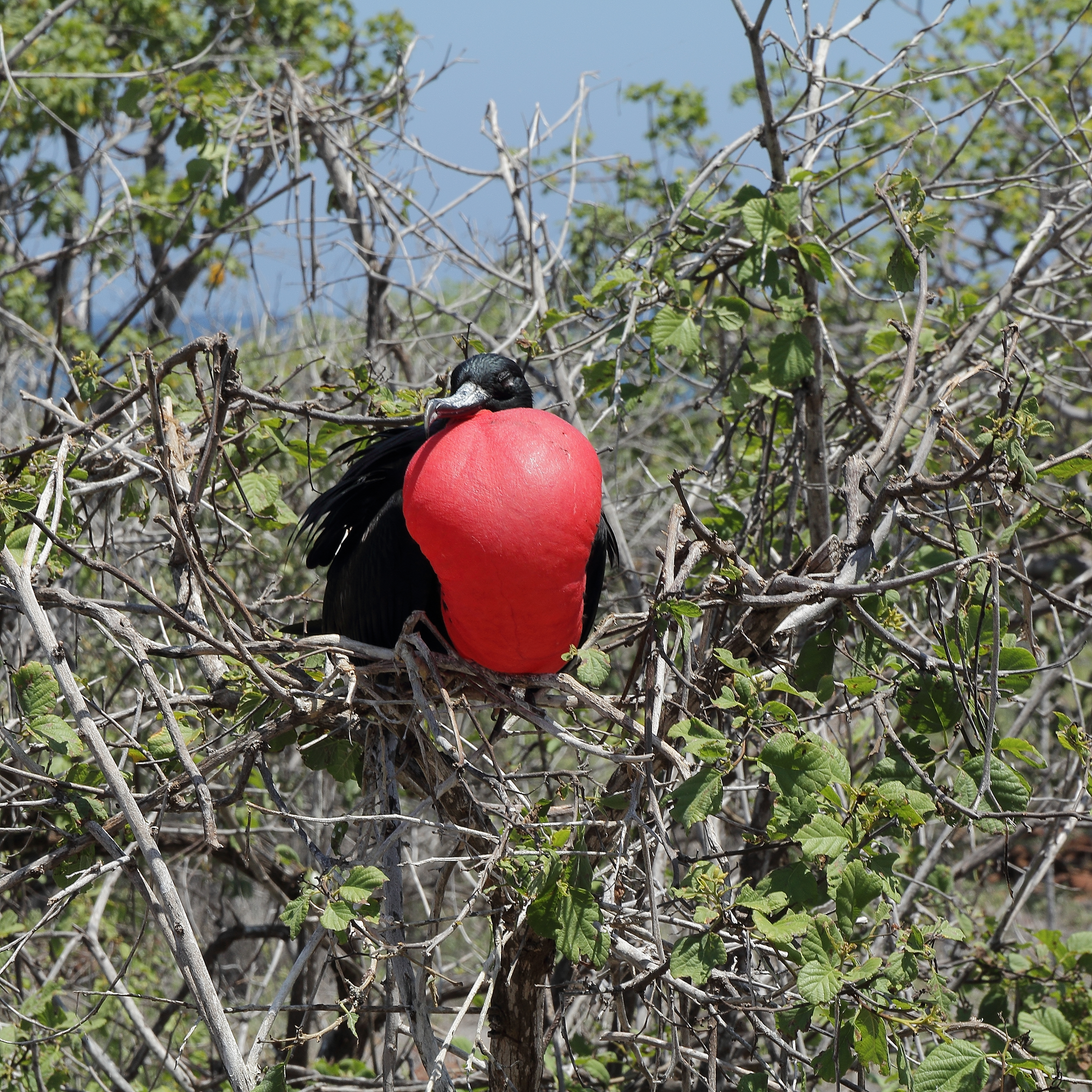
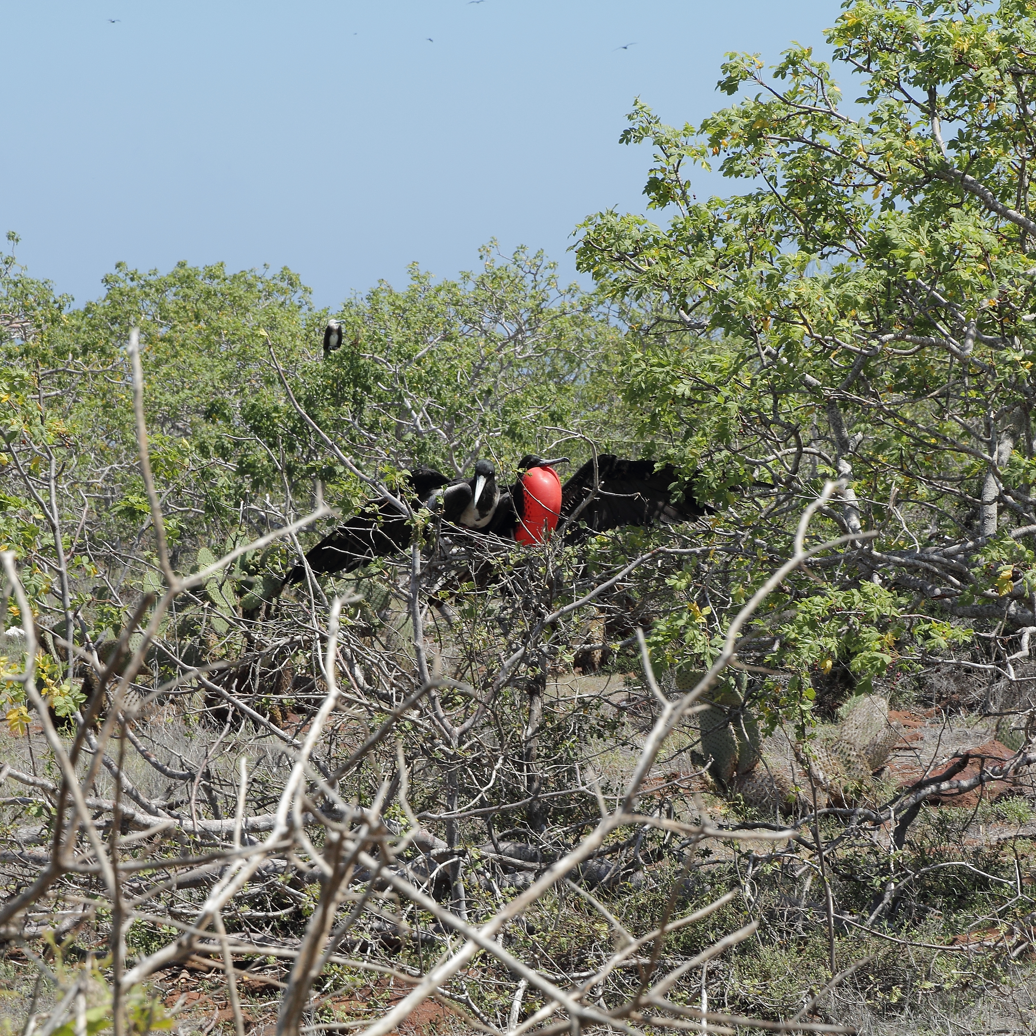
| | | | But here we are just having arrived on North Seymour. I am today more observant of certain things than I was when I got there, but let's see what you see in this picture on North Seymour (Photo by Galapagosonline). | | | | Well, of course the cactus catches your attention right away, and you'll remember it's a prickly pear cactus, more scientifically, Opuntia echios var. zacana, endemic to North Seymour, as we cited above. Now, as for observation, see how long you have to stare at this cactus before you realize you're also looking at a land iguana. And this being North Seymour, we can be confident it's Conolophus subcristatus, the regular, garden-variety, plain-vanilla Galápagos land iguana. Of course, it also helps that it's not yellow or pink, but instead the usual black-with yellow. While it's not overly hot on this breezy corner of North Seymour, these iguanas regularly seek the shade of cactus, other shrubs, or rocks, against the midday sun. Generally speaking, I feel for them. | | | | Take one last look at the picture. Do you see anything else worth discussing? Click on the background and inspect the scrub brush, the lush, low bushy vegetation, some of which seems to be either dying or dead, leafless or almost so. The dwarf palo santo trees fooled me, too. I spent my whole time on the island thinking I was walking among herbal death, and have only found out now, months later, how interesting—also attractive, but that has to grow on you—the flora here is. I'd heard there were palo santo trees on North Seymour and elsewhere, but had no idea before what they were. | | | | For me to fully understand the palo santo tree, I have to imagine trees that have fragrant woods or saps, even barks. Smell a cedar closet, or even a freshly sharpened pencil, and you have the most obvious example of a fragrant wood, cedar. Cinnamon comes from the bark of the cinnamon tree, and frankincense and myrrh, which are actually relatives of the palo santo, have fragrant woods and saps/resins/gums. This is how I try to understand the palo santo. | | | | While palo actually means pole, or stick—think of Palo Alto ("High Pole"), California—it's best to translate palo santo as "holy wood" because—as I read, but did not sample—the wood is fragrant and is used as incense, or as burning sticks, as well as to craft objects. It's native to most of Latin America from Mexico south, including the Galápagos. The sap contains an aromatic resin, and the essential oil, called palo santo oil, is used as an ingredients in cosmetics. The wood and oil also have wide, traditional uses, going back to the Inca era, in folk medicine, especially in Ecuador, for stomach ache, as a sudorific (sweat producer), and as a liniment for rheumatism. It's also used to "clear one's house" from mala energía (bad energy), and for good luck. | | | | The reason the view in the picture, and in reality, looked so dour is that palo santo trees lose all, or most of, their leaves during the dry season to help stop water loss. This leaves their very distinctive skeletal frame looking like dead wood, exacerbated by their naked-looking gray trunks and branches that give the appearance of bark loss. They are also covered with lichen—which I clearly remember—which adds to their sepulchral look. However, palo santo trees burst directly into leaf after a rain. | | | | Now that we know what we're talking about, we have to point out what's special about these trees in the Galápagos. There are two kinds, full-size and dwarf. The full-size palo santo is Bursera graveolens (Photo by Haplochromis) and this is the one whose habitat is all of Latin America, but also including the Galápagos. There were some on North Seymour, but I wasn't concentrating on trees, especially ones I thought were dead. Click to inspect that there are some leaves in bloom on this tree. This species is not endangered. | | | | But there is the smaller cousin, Bursera malacophylla, called the Dwarf Palo Santo. This species is not only endemic to the Galápagos alone, it only appears in northern Santa Cruz and "associated islands", which obviously includes North Seymour and I assume Baltra. This is the tree I clearly remember walking among and actually remember quite well, since it's about the height of a person. I also appreciate it more now that I know it's not dead, just looks a bit lifeless. The dwarf palo santo is also known in English as the Galápagos incense tree, an elegant-sounding name. However, this species is endangered. Once you know more about this tree, this picture becomes quite idyllic. The distinctive, almost-bare, gray skeleton has its own charm, to compliment the prickly pear cactus. | | | | Once we were all on land, the group split up. Adolfo took the Spanish speakers counterclockwise to the boobies first (see island map), and I went clockwise with Diego's English-speaking group to the frigatebirds first. The trail you see is about 2 km (1.2 mi) long. Passing iguanas and dwarf palo santos, we came to the nesting area of the first of the two kinds of birds North Seymour is most famous for. Since we discussed both birds in 2015/11, we'll only add pictures here to fill out the course of the day trip. | | | | First we came to the nesting area of the magnificent frigatebird. At first we see the male puffing up his pouch for the females flying overhead, and now we know he's sitting in a dwarf palo santo! If you wonder to what extent the red color identifies a bird, click to enlarge until you find the two other males at the bottom of the tree by their red pouches. These are the females flying above (Both photos by David Adam Kess) inspecting the land below for potential partners. | | | | I've found a lot of good online pictures, and, since there were dozens and dozens of males on the ground in actuality, I don't think it's overkill to show several. Here's a side view of a male giving it his best effort (Photo by Haplochromis), and here's a front view (Photo by C T Johansson). This is a male who thinks some wing-flapping might help (Photo by Hans Stieglitz). Notice how clustered together the potential nests are.
| | | | If you click, you can spot the female (Photo by C T Johansson), and thus identify the male who "got lucky", while his two friends in the background are still at it. This is a mating pair in a nest (Photo by C T Johansson) in a dwarf palo santo, and this is a detail of another happy couple (Photo by "me" [sic]). They will later alternate sitting on the nest to hatch the young. | | | | As we in Diego's group reached the far end, we crossed with Adolfo's group coming in the opposite direction, which meant that we were now about to enter the nesting territory of the blue-footed booby. It was at this point that I spoke in German with the Austrian couple in our English group, as reported in 2015/11, to confirm what I had learned about the German name of the bird, Blaufusstölpel, that my new word, Tölpel, meant "fool", just as the word I'd known, Narr, did. While this area was very extensive, the nests were more widespread, but I finally saw one where the male was doing the mating dance of foot-raising and sky-pointing. | | | | This is a mating pair of boobies, both looking skyward and one with a raised foot. They, too alternate on the nest (Both photos by Vince Smith). Notice the typical circle of droppings. And both incubate the eggs by warming them with their feet (Photo by RJHall), not their breast, as other birds do. | | | | After we saw the boobies, the path continued through the dwarf palo santos toward the landing, but then suddenly changed. Actually, for a stretch it just disappeared, and we had to start climbing over some very awkward rocks to get to where the path continued. Wearing my usual Birkenstock sandals, the going suddenly became difficult. I felt I had to reach out toward Diego, who offered me his forearm, which got me across the area. I don't ever recall having to do this in the past. Then, a short distance later, we were at the top of the "steps" leading vertiginously below, and before I knew it, the young Austrian guy took my arm and we went down the steps, where Diego then helped everyone over the prow of the panga. Two instances like this within moments of each other. I hope it wasn't age showing. | | | | Back on the Santa Fe III, the hot lunch was served, which I took on the top deck. While there had been no specific snorkeling time, we were told we were going to a beach, where people could either sit or swim and snorkel. This did not interest me, except that we were also told there was a slight chance we could see flamingos here, and my ears perked up. | | | | But once again, the dearth of additional information bothered me—I don't know about anyone else. Where was this beach? On an islet? On a far side of North Seymour? On Santa Cruz? Just as with the snorkeling stop going to South Plaza, that turned out to be at Punta Carrión, I didn't know where we were until I got home and read that standardly, day trips to North Seymour stop at Las Bachas beach on the north shore of Santa Cruz. If you look at the Santa Cruz map, las Bachas is located about where you see the blue word "Negra". More precisely, look at this:
http://www.galapagospark.org/sitiosdevisita/playa_las_bachas_foto_01.jpg
| | | | I had mixed feelings, but I wanted to try to see flamingos. Adolfo had explained that there were two lagoons behind the dunes on the beach, either of which might have a flamingo or two. We'd be stopping at the east end of the beach, near one lagoon, but the second lagoon was at the far end of the beach. Adolfo, as always, was very understanding. He knew I was not interested in snorkeling or sitting on the beach, but said he'd work things out. | | | | We all got into the panga and for the one and only time for me in the Galápagos, had a wet landing. It was beautiful. It was the type of landing we'd almost always done in Antarctica, the only difference being that there we were issued boots to step into the water in. Here, when the panga approached the beach, the driver pushed the prow into the sand, and one by one, we slid forward, then pivoted around so both legs swung out into the water, which was ankle-deep and beautifully warm. There was no struggling over the prow of the panga as on a dry landing. | | | | Adolfo and I, and a few others, scrambled up the closest dune and looked over the top to see an empty lagoon. Others then went about their business, including taking a long hike to the lagoon at the other end (they did end up seeing ONE flamingo), but as Adolfo had planned, since I wanted none of it, I got a private panga ride back to the boat. I'm glad I tried stopping here, even for the short stay, because I enjoyed the wet landing and my short time on the beach, even sans flamingos. Back on the boat, I used the time to lie down on one of the benches behind a dining table and take a nap for the remaining 45 or so minutes the others were gone. I hope this isn't another sign of age! | | | | Although Las Bachas was indeed a beautiful beach (under the blazing sun), one of its most interesting aspects is its name. During WWII, the American army left two discarded barges on this beach. Local Spanish-speakers had difficulty saying "barges", which resulted in "bachas", hence Las Bachas beach! | | | | From the ferry dock our bus took us back to Puerto Ayora. That evening, my last one in town and in the islands, I decided three stops at the Pelican View were enough, so I went back to the other restaurant in the center that I liked, Il Giardino, and did what solo travelers and solo diners often do, had dinner at the bar, chatting in Spanish with the bartender. | | | | A Morning Visit to an Artisan Coffee Farm The next day was Saturday, departure day, but which included a stop on the way to the airport. Just as I'd booked myself a not-too-early flight TO the islands (arriving at 11:30, which turned out to be in time for the tropical storm), I'd booked myself a midday flight FROM the islands, leaving at 12:30. I was then rather surprised to have been handed a slip of paper the evening before saying I should be ready for the airport and tour pickup at an unconscionable 6:20 in the morning. The tour couldn't take THAT much time (it didn't)! So I got up before dawn, and before breakfast service started at 6:30, to wait in the open-air lobby with some others. Once the bus pulled up, someone came running out of the hotel with boxed breakfasts, a sandwich, juice box, and cheese and crackers. Couldn't they have TOLD us that was going to happen? I really hate to be out of the loop when traveling. | | | | The stop was billed as a visit to a "coffee plantation", with little other information. There was also no indication as to where it was. But this time, my sense of direction told me that it was when the bus got to the village of Bellavista (see Santa Cruz map) that we turned off for a short distance to the east. Of course, I can't be sure. | | | | Onto a side dirt road and we came to a structure in the rain forest. It was a very large wooden roof supported by log columns, but with no walls. This is not surprising in the tropics, where open sides to buildings are common because of the mild weather. A sign said "Trapiche Ecológico", with no further explanation. Beyond that, the look of the place could have indicated we were visiting Robinson Crusoe and some makeshift devices he'd built on his desert island. Yet this visit turned out to be one of the nicest stops on the Galápagos trip. | | | | But before we get to the visit, I have to fill in all the blanks so we understand what we're talking about, which, of course, I only was able to look up long after the fact. Yes, there are still farms, even ranches in the Galápagos—one included the entry to the tortoise reserve--that were grandfathered in when the National Park was formed. We were told at the time by the presenter, Vicente, that this farm—a more accurate term than plantation—was founded by his father. But then he didn't go into details and just talked about coffee. I find now that the farm covers 35 hectares (86.5 acres). A tiny area is for fruits and vegetables, and the rest is grazing land. Only 5 hectares (12.4 acres) are used for sugar cane and coffee, both common crops in the islands. Of that already small area, only about 2 hectares (5 acres) is used to produce 1,500 kg (3,300 lbs) of coffee a year, so they are quite small producers. But none of this, not even the hacienda was visible to us as the bus let us off to this primitive coffee processing area in the woods. Its isolation and primitive, artisanal style gave it a bit of a "lost" feeling. | | | | As it turns out a trapiche is a sugar cane press, and an ancient, wooden antique of one was pointed out among the coffee equipment, but only when I asked about the word. I'm going to say that the name of the enterprise, El Trapiche Ecológico, which seems to be "The Ecological Sugar Cane Press" might be twisted around to be "The Organic Sugar Cane Press", which still is odd as a name for their line of organic coffee. But the point is, this is organic, artisanal coffee being produced and processed here, as you might have artisanal cheese or artisanal bread. While there are other farms that produce this type of coffee, this could possibly be the only one that demonstrates its methods to visitors as part of a program of "agrotourism". | | | | My experience with seeing coffee grown was in Hawaii, and is minimal, but for me, highly memorable. Since here Vicente showed us nothing of the growing, only the processing, that background is worth filling in here. One of the loveliest places in Hawaii is the Kona Coast on the west side of the Big Island. In 2008 I found a wonderful place to stay during my visit, way up on the mountain slopes above Kona. For fuller details, see 2008/25, but I'll summarize a little here. The Holualoa Inn has a to-die-for view over the coast and its sunsets from the slope of the Hualalai Volcano. Beyond that statement, I'll quote myself from 2008/25: | | | | | | “Pastoral” is a good word to describe the grounds, which extend to 12 hectares (30 acres). The inn is actually the center of a Kona coffee estate. . . . You can walk to the edge of the garden to inspect some of the coffee bushes, each with clusters of green olive-like coffee berries. Break the not-too-thick skin of a berry and the two halves of the very white and moist coffee bean will fall into your hand. But some of the berries have ripened and are bright red, now referred to as a “coffee cherry”. These are handpicked and sundried, then sent to a local mill that roasts and grinds the coffee, returning it to the estate for sale. Morning coffee everyday comes from coffee that was only recently grown right on the estate. |
| | | | I think that covers the cultivation aspect. I can add that to my mind, olives and coffee berries are used in opposite ways. With olives, we eat the flesh and discard the pit. With coffee berries, we discard the flesh and roast the pit, which we call a coffee bean. Copy and paste these links to see illustrations of coffee berries and fresh coffee cherries, neither of which Vicente showed us in the Galápagos:
http://grandesempresas.mx/wp-content/uploads/2012/08/DSCN2557.jpg
http://cdn.c.photoshelter.com/img-get/I0000Z20xGSg3j78/s/750/750/coffee-galapagos-66.jpg
| | | | Now move your mental image from the cultivation on the Kona slopes to the processing in the Santa Cruz rain forest. However, I am not being facetious (well, maybe a little), when I say the processing area was barely beyond what Robinson Crusoe would have primitively jerry-built on his desert island, should he have wanted to process coffee. Copy and paste:
http://i.ytimg.com/vi/EyYPy6eNyxk/maxresdefault.jpg
| | | | Vicente lectured in Spanish, and the guide translated. He first stood in front of a large wooden mortar on the floor. In it were apparently coffee cherries that had already been dried out, probably in the sun, so that the flesh was a dried-out crust clinging to the coffee bean. He then picked up a large pestle (lying on the ground behind him in the picture) and pounded the beans in the mortar to break away the dried crust. He now had what is the equivalent of "wheat" and "chaff" blended together. How he separated them really made me smile:
http://grandesempresas.mx/wp-content/uploads/2012/08/DSCN2541.jpg
| | | | He was going to fan the dry, fallen-off chaff away from the beans. He did not use an electric fan. He did not use a regular hand-held fan. He picked up a fan that had been jerry-built out of some bird feathers—see the picture—and, as he poured the contents out of a bowl, the berries fell downward and the chaff was fanned to the side. Priceless. | | | | He was then ready to roast his beans. His roaster is shown in the background of the first picture, but this is a much better view:
http://cdn.c.photoshelter.com/img-get/I0000RjebRY6cH40/s/750/750/coffee-farm-galapagos-67.jpg
| | | | The long-handled roasting pan hung from the ceiling, and, as this worker shows, the beans were shaken back and forth over a wood fire. The beans would then be ground and packaged. After the demonstration, we went to a buffet to sample the coffee. It was marvelous, and it was just so charming that this organic, artisan coffee was so primitively produced. | | | | Look again at this last picture. I like it for three reasons. It idyllically shows the primitive artisan roasting method. It shows the open-sided primitive building on poles. And right behind, it shows a beautiful, red-and-yellow croton plant. It represents a pleasant, non-wildlife memory of the Galápagos. | | | | The coffee is sold at US$12 per kilogram (2.2 lbs). Charming as the whole artisanal thing is, the thing that takes a slight edge off it is that, while you think the coffee would be sold primarily to the local population, apparently only part of it is, while 70% of the sales go to visitors like us. | | | | | | There is one last thing I mischievously have to tell about. When we first arrived, as people were still getting off the bus, there was an incident. I saw it happen, but will have to reconstruct what must have led up to it. Our guide was facing one of the men on the bus. Behind him was one of the large wooden posts holding up the roof, and some distance behind that were the restrooms. I can only guess that he was asking her where the restrooms were, because as soon as she answered, he spun around and bounced right off the pole, knocking him down to the floor. He didn't walk into it, he just pivoted right smack into it. He was picked up and seated in a chair during the demonstration, and seemed to recover later on the bus.
I mention this under the rubric of Galápagos war wounds. I got my shin bruised on the collapsing plank, then my hip bruised on the roiling ship, but neither was a problem. Anyway, the surroundings did those things TO me, so they were passive acts on my part. In his case, he can't blame his surroundings. He did it, actively, to himself, and really must have felt embarrassed. I do hope he eventually got to relieve himself. I suppose I'll have to yield the medal for Galápagos war wounds to him, though.
|
| | | | Ah, but we're not done. I've found on YouTube Vicente's lecture about making artisanal coffee. It's in Spanish, but runs for only 2:56. I'll walk you through it. | | | | He starts the video by showing what he did not show us at the time, the green coffee berries and red coffee cherries. He then moves into the covered work area and at 1:00, compares the fresh and dried coffee cherries, and at 1:15, uses the mortar and pestle on them. At 1:35 he uses his super-duper bird-feather fan to separate the chaff from the beans and at 2:00 goes to the roaster. At 2:35, he shows roasted beans, and says it took about 30-35 minutes to roast, a fact I'm learning just now myself from the video. | | | | A drizzle had started while at the farm, and as our bus arrived at the ferry landing, it became a bedraggled experience. We schlepped in the drizzle onto the humid, crowded ferry, then off it on the Baltra shore, where the airport buses hadn't arrived yet, so we stood under whatever eaves we could to keep out of the rain. It felt like we were refugees fleeing a war. Would we finally make it? But when we got into the modern terminal, all went well, and the guide remained with us until we checked in. | | | | And I got a surprise. By now it was about nine-ish, and the agent looked at my 12:30 reservation and wondered why I wasn't leaving on the next flight at 10:00. Only then did I realize why I had been picked up so very early, at 6:20. Without telling me, the tour people were apparently doing just the one morning airport run, with the tour, for both flights. He said he had room on the earlier flight, and, since the 2h30 difference was substantial, I jumped at the chance. But I was concerned about being met, since I hadn't arranged my pickup with the tour company, but had made use of the free Sheraton shuttle. I told the guide, and she said that was no problem. She'd call her office, who'd call Sheraton, and make the change. | | | | The 1h50 flight, plus losing an hour in the time-zone change, was uneventful, and in Guayaquil, the guy from the shuttle had my name on a sign. I had again booked the Club Floor for a pittance over the free points for the room. I took a shower, and a nap, because of the pre-dawn start. In the evening, the free Ecuadorian snacks with wine in the Club Lounge served as dinner, and the following morning I had breakfast there, too, ready to be picked up to go to the rail station for my train adventure up into the Andes to Quito on the Tren Crucero. | | | | Travelers Century Club As you know, the TCC doesn't count countries, but destinations of importance to travelers. It compiles its list by differentiating political jurisdictions (not just an all-encompassing "China", but China-Tibet-Hong Kong-Macau) and also major islands or island groups (France and Corsica). This trip is a perfect example of that. It took place exclusively in Ecuador, and if one was just literally counting countries, it would be one country added to one's list. But to a traveler, there's a major, and very logical, difference between mainland Ecuador and the Galápagos, so it makes perfect sense that the TCC counts each separately. | | | | I already have Ecuador on my list, since the Caronia docked in Manta, on the mainland. I didn't see much of the country, but I was there, and counted it. Of course, it's always better to do what I did on this trip, seeing the rest of the country much more thoroughly. | | | | But the Galápagos was a new destination. Tibet was # 148 for me, so the Galápagos brings me up to # 149. I'll say once again that of the 324 destinations listed by the TCC, I have absolutely no interest whatsoever in most of the remaining ones, which include obscure islands and countries that to me are of little interest, largely in Africa, the Middle East, and some of southern Asia. I will not name the very few additional destinations I could be interested it, but I would like to break 150, which would give me Silver status in the TCC. Other travel in the future would be to repeat places—as Ecuador itself is a repeat right now. | | | |
| |
|
|
|

