|
Reflections 2018
Series 11
November 5
Hotel Barge II: Chablis, Auxerre, Noyers, Vézelay, Bazoches
| | Other Excursions A large part of my stated preference for solo travel is how I do excursions, while meeting and interacting with people ad hoc along the way, but not having to take up residence with them for days on end,. I craft carefully in advance what I want to do from guides like Michelin and Frommer, add some ideas of my own, and we have custom-made excursions. We can use Paris as an example of excursions I like: the walking tours of Montmartre, Passy, Rue Mouffetard and others; the Métro tours across Paris, over specific bridges, or in a circle in the center. You take it at your own pace, adding or subtracting as you see fit. | | | | But group travel remains part of the travel game, and there are advantages in meeting people on a regular basis--up to a point. But let's take a look at excursions as they come up with other recent coastal, river, and canal trips. | | | | Some cruises just stop in towns, or have a shuttle to the center of town. There may also be some sort of a tour, and I review them all, but most are of little interest to me. My benchmark is, if I were driving a rental car in the area, would I stop at that place on my own? Often not. Usually walking around the center of town with a map I'd printed out in advance is fulfilling enough. | | | | Typical of this was ACL's American Star trip on the US East Coast from Charleston to Baltimore in 2016. In ports, I remember doing a lot of walking on my own in town. Of course, taking the organized tour to Kitty Hawk was a must-see no-brainer. | | | | On Sweden's Göta Kanal in 2006 and Canada's Rideau Canal in 2014, the trips were wonderful, but excursions consisted of self-guided visiting of towns along the route, nothing at a distance. On the Grande Mariner in 2016, tours were offered which I found uninteresting, and I preferred to walk around the port towns on my own (Québec, Trois-Rivières, Troy). | | | | Well-planned excursions almost as good as the Luciole's were on the American Queen on the Lower Mississippi (2014) and Upper Mississippi (2015). Those routes, though were on a much larger scale, crossing huge swaths of the US. A bus would follow the ship on land, and prepare a visit in the upcoming town by setting up numbered billboards at specified locations on a map distributed to passengers. The bus then served as a shuttle between those locations for the rest of the day, moving on to the next port overnight. That was very well-planned and executed. | | | | Excursions on the Luciole Also very well-planned and executed were the excursions on the Luciole. A string of nearby destinations (only a couple were close to or right on the canal) were excellent choices, and the Luciole used a similar pattern as the American Queen. But our route on the Nivernais was so petite, that guide Andy didn't need to do any following along. He simply took the van home with him every day (the same one as we came on from Paris) and appeared the next day, morning or afternoon, for the next excursion.
https://www.bargeluciole.com/assets/images/itinerary-web.cruise.map.pdf
| | | | This map, from the Luciole website, shows our precise route from Auxerre to Clamecy running north to south. Hold on to it. You can see where the canal runs within the Yonne, and where it runs next to it, similar to what we found on the Oswego Canal in NY. Note the markings for towns. You can see Auxerre is the largest, and Clamecy is also of good size. The red line along the canal shows which side the towpath is on, or where it's missing. Note the cliffs, bridges, and locks. Guard locks are where river water is added to the canal to keep it deep enough. | | | | The inset shows an oddity. One of our stops will be in Accolay, which is neither on the Nivernais Canal nor on the Yonne River, a point not fully clarified on board. As you see, the Cure River here enters the Yonne as a tributary, and the stub of a canal we'll be on will be the Canal d'Accolay. I find the route the towpath has to take at this intersection to be interesting. A rail line also crosses here. | | | | To show how compact our route was, I have some numbers, mostly collected from Google Maps.
The driving distance from Paris to Auxerre is about 167 km (104 mi).
The combined return route, Clamecy-Auxerre (western edge)-Paris comes to about 210 km (131 mi).
On the route map, the canal distance from Auxerre to Clamecy adds up to about 59 km (37 mi).
That's averages only 11.4 km (7.4 mi) per day, which is really not very much.
The corresponding driving distance is about 43 km (27 mi), making the water route about 37% longer.
| | | | Now when we were looking at the departmental maps of Yonne and Nièvre, I pointed out all the tour destinations we'd be visiting. It's rather odd that, other than those couple right on the canal, every destination lay to the east—or southeast--and I don't know why everything interesting lay in that direction. Below is a summary of the principal destinations of our excursions. I say "principal", because three of the excursions, starred below, had noteworthy unannounced extras en route to the main destination. For the sake of completeness, extra destinations are included in the daily headings.
Day 8 NE Vincelles-Chablis 22 km, 27 min
Day 9 backtrack Accolay-Auxerre* 24 km, 25 min
Day 10 E Accolay-Noyers 26 km, 25 min
Day 11 SE Mailly-le-Château-Vézelay* 23 km, 29 min
Day 12 SE Clamecy-Bazoches* 33 km, 32 min
| | | | It seems to work out that all tour drives were roughly a half-hour from the canal (25-32 minutes) at an average distance of 25.6 km (15.9 mi). If each day's progress on the canal was only 11.4 km (7.4 mi), it's easy to see how the route for one day's excursion might intersect that of another's, which happened regularly. I remember our driving across a number of intersections more than once. | | | | | | Driving note: Andy indicated from the front seat of the van that he was blowing into a tube before he could turn on the ignition to get moving, and said that it was a requirement. I think having a breathalyzer requirement to cut down on drunk driving is an interesting novelty, but later research shows that, while this French law was indeed passed, at least in the beginning it proved impossible to enforce, and was ignored, no fines being issued for not having one. One major problem was that there were only two small companies in France making the devices, and there wasn't an adequate supply to go around. The law has now been postponed indefinitely. |
| | | | Day 8 M11 Chablis Day 7 had been the arrival day from Paris, followed by the reception, cabin assignment, dinner, and the evening under the stars with those night views of Auxerre (the Auxerre day visit would be on day 9). We spent the night docked in Auxerre, and left the next morning at about the time of breakfast, and our first full day included a morning enjoying life on the canal, as described earlier. On the route map, you'll see that the canal here stays largely within the Yonne as you follow us from Auxerre to Vincelles (Photo by Pline). This picture shows the canal near Vincelles, where the towpath is now a walking and bicycle route. Click to see that the sign on the left says that Cravant (on the route map) is just 4.5 km ahead by bike. You see the Do Not Enter sign for motor vehicles, which adds Sauf Riverains et Service, declaring an exemption for those living there, or servicing them. The map on the right is like ours, but emphasizes that it's indicating in green dashes the véloroute along the towpath. | | | | | | Word Study: The French word for "bicycle" can be bicyclette, but that's a bit formal, since vélo is very commonly used, as shown. It's short for vélocipède, and you may recognize "velocipede", borrowed from French, as a rarely used English word for an ancestor of the bike. The word was formulated in French from Latin velox (genitive velocis) "swift, speedy", plus pedem, accusative of pes "foot". That seems to say that as an alternative of walking, you can instead use this "swiftfoot" or "speedy foot". An oval or circular track for bike racing is a vélodrome, and "velodrome" is also used in English. It's also worth keeping in mind that "velocity" uses the same root.
While the above words compare this form of transportation to the foot, the other word(s) more abstractly merely count wheels: unicycle, bicycle, tricycle. I assume bicyclette has the diminutive ending because older bicycles were taller.
|
| | | | Chablis (AOC) Andy met us in Vincelles in the afternoon and off we went for a wine tasting in Chablis. Below is a map of all of Burgundy, with its principal wine regions. As you can see, most of the famous names are well southeast of where we are, but Chablis is right near us.
https://www.hereandtherewithpatandbob.com/wp-content/uploads/2010/09/Burgundy-wine-map-large.gif
| | | | To see where we went, go back to the route map and find Irancy, so you can confirm that it's not far from Vincelles, where we began. Unfortunately, no maps were ever provided for any excursions as to what route we were taking or precisely where we were going until we actually got there, so my vision of where in the Chablis region we were was totally lopsided until this writing. My impression was that we went beyond the village, so we could easily stop in it on the way back, but as you'll see on the next maps, that was not the case. It would be quite helpful and aid in orientation if the Luciole website added, in addition to the excellent and very helpful route map, a supplemental map showing where the excursion destinations are, including intermediate stops. Now move to the first map below:
https://www.bourgogne-info.eu/jpg/Chablis.jpg
https://www.bourgogne-wines.com/gallery_images/site/3/19988/19989/20041.jpg
| | | | This first map covers a closer-in area, yet covering everything in our region. I only now discover that the wine estate we went to was in Préhy (pré.I), the southernmost town in the recognized Chablis area, and the town of Chablis was beyond that. But locate here the Serein River we mentioned earlier and note that Chablis village is right on it, and so is Noyers, which we'll visit on Day 10. Everything here is close by. (Note for later reference the town of Tonnerre, and its distance from Noyers.) | | | | The second map is closest-in of all, and is clickable for details. As I try to reconstruct the route we took, we must have come in on the D2 to Préhy, then continued on it to reach Chablis village. | | | | | | Comestibles such as wine, cheese, and much more are regulated in Europe as to source, and all established names are highly restricted. For instance, the only cheese that may be called Roquefort is cheese actually produced in and around Roquefort-sur-Soulzon in the south of France. Any similar cheese made elsewhere has to come up with another name. Thus, to name a wine Chablis, it has to come from one of the areas indicated on the second map, further subdivided as to quality. This is an example of the Appellation d'origine contrôlée (AOC), literally the "Controlled Naming of Origin", but perhaps better phrased as the "Protected Designation of Origin". Incidentally, all Chablis is made from Chardonnay grapes, and none other.
On this map, the dark brown area north of the village is where the highest level of classification of the Chablis wines is grown, the Grand Cru ("Great Growth"). Gold shows the next level, the Premier Cru ("First Growth"). Préhy is in the yellow area of regular Chablis. I assume Petit Chablis in green is of lesser quality.
Do not be misled by the name Chablis. Chablis had won such worldwide recognition, that the name began to take on generic connotations to refer to any dry white wine, even those not made from Chardonnay, and possibly of poor quality. When standing in the Chablis AOC area, or whenever drinking a wine from it, you are not talking about generic whites, but the real thing.
|
| | | | I really know very little about wine, but I know where I learned a bit about wine growing. When we were studying that year in Mainz, Beverly and I audited a few courses of interest for a short while, but we signed up for the Weinbau course and stayed with it. The word is literally "wine cultivation". | | | | | | The English word corresponding to Weinbau takes two forms, both developed in the late 19C. The form I consider ugly and try to avoid (though it's often used) is "viticulture", based on Latin vitis "vine". The far better form in my view is "viniculture" based on Latin vinum "wine".
I've also seen this statement: viticulture refers to growing grapes for any reason, while viniculture means growing of grapes specifically for making wine. That sounds nice, but it sounds like wishful thinking, and the words don't really seem to be used that way. After all, how often does on speak of growing grapes for other reasons than wine?
|
| | | | The Weinbau/viniculture class had frequent weekend excursions. We'd meet at the Mainz railway station and would take local trains to nearby locations along the Rhine, usually walking from the stop to a nearby vineyard. Everything was so compact. Below is what I remember most significantly. | | | | Rows of vines are ideally not on a flat surface, but sloped, best on a hillside, to promote drainage, meaning the rows run from top to bottom. The slopes, wherever possible, face south, to get the most sun. Often stones—slate is best, because it's reflective—are put under and between the rows of vines to reflect sunlight onto the grapes from below—the more sun, the better--as well as to help drainage. | | | | This is a panorama (click) of the Grand Cru vineyards north of Chablis village (thus, they face south). We were there during the September harvest time (Both photos by CocktailSteward), so we saw a bit of activity. This view is of a Premier Cru vineyard, Fourchaume, named on the second map. | | | | Andy made a stop in the field before the actual tasting, and it was an exhilarating experience. We stopped on a hillside at the upper end of some rows of vines (Photo by Peter), which looked something like this, with a beautiful, distant view downward and across the hills. You can see from the shadows on the ground that this hillside faces south, and if you click to look at the ground, you'll see, not slate, but numerous gravel-like pebbles to reflect the sun upward. He had us pick a grape or two to taste what they're like right off the vine. These are Chardonnay grapes on the vine (Photo by BerndtF), but—full disclosure—this particular picture was taken two hours north of the Chablis AOC in the Champagne AOC village of Avize, so they'll end up in a bottle of Champagne and not in a bottle of Chablis.
http://fineterroir.com/content/uploads/1354718985_Chai-depuis-les-vignes-800x531.jpg
http://s-www.bienpublic.com/images/464d5a1b-dd60-479b-bf7e-899505a34c55/LBP_v1_02/jean-marc-brocard-1462194398.jpg
| | | | As we arrived in what I now see has to have been Préhy, we stopped at what we were told was the Domaine Jean-Marc Brocard, whose main building is seen in the first picture among the vines, near the church. Jean-Marc is in the second picture with a rear view of the buildings--I don't believe he was among the people we met.
https://www.zeendoc.com/var/zeendoc/storage/images/temoignages/domaine-brocard/6609-3-fre-FR/domaine-viticole-jean-marc-brocard.jpg
https://www.klwines.com/images/skus/1233231x.jpg
| | | | We were given a tour of the facility, including processing and storage areas, some being underground. We then settled down in a tasting room and tasted several of the Brocard wines. Everything was, alas, explained in English, with no trace of French but the names of the wines. | | | | | | This is in contrast to 2002, when Beverly and I visited the cellars of Veuve Cliquot Champagne in Reims. The writeup in 2002/5 is skimpy (but informative), just two short paragraphs, as all writeups were back then in the beginning of the website. I'll just copy this much: I like Veuve Clicquot Champagne . . . We made rail connections to Reims in northern France . . . mostly to have a tour of the Veuve Clicquot . . . Champagne cellars. You have to do it by appointment only, so I planned it online, making sure there was an elevator for the wheelchair. We ended up with a private tour. I asked for it to be in French. It was. I'm not saying I understood every word—I didn't--but it was a cultural thrill to do it that way. |
| | | | Along with the wine tasting we were served a traditional local specialty, a puff pastry called a gougère (Photo by Luigi Anzivino). It's a baked savory choux pastry (used in éclairs, crullers, beignets) mixed with cheese, usually grated Gruyère or Emmentaler. Not only are they a Burgundy specialty, I've since read they are believed to have come from Tonnerre, mentioned on that earlier map, and that they are, sure enough, generally served cold when tasting wine in cellars, though they can also be served warm as an appetizer. | | | | I'm glad we got to try some gougères (Photo by Fxcuisine), as I LOVE learning about local specialties, but I have to be frank. As eager as I was to taste them, I didn't particularly care for them. Despite the cheese flavor, I found them about as tasty as eating the shell of an éclair with no filling. They were also served one evening with dinner on the Luciole, and I didn't like them any better. Oddly, gougères and that Kir Royal the first night were the only two Burgundy specialties served on the Luciole, a point I'll speak to at a later time. | | | | Chablis (Village) When we first arrived in the Chablis area, Andy said we'd make that roadside stop, plus go to the tasting, but we needn't go into Chablis itself. I thought that odd: if you show me a donut, also tell me about the donut hole. After the tasting, he made another passing reference to the town, and I spoke up and said it would be nice to have a quick visit, and he readily agreed. Now again, without a map, I'd pictured it to be on the way home, but the second detailed map now shows it wasn't, but no matter. If you're going to do something, do it right. | | | | It was just a few minutes further and we got a very nice view of Chablis village something like this (Photo by Espirat), though this is a springtime view. Driving up from the south, we entered at Porte-Noël (Photo by Christophe.Finot), which led right to this typical street (Photo by Paul Arps), which brought us to a little square where we got out to look around for a few moments. We didn't get to see the Serein in Chablis (Photo by Christophe.Finot), but here it is. We then returned to Vincelles and the Luciole.
| | | | Day 9 T12 Bailly & Auxerre In the morning we sailed from Vincelles to Accolay, so this afternoon is the day we physically left the Yonne for the Cure and left the Canal du Nivernais for the Canal d'Accolay (see route map). This is an aerial view of Accolay (Photo by Commune d'Accolay), which is unfortunately "upside down" since it faces south. Click to see the Cure (near us on the north side), the canal, the 12C church, and the village.
| | | | This is our "backtrack" day to see Auxerre by day, since we'd seen it only at night. Check our route map, since I've now figured out how we got there: locate Irency and Bailly on our driving route. We stopped first at Irency (we'd been through there yesterday!) where we again stopped on a hill at the upper end of a vineyard, and tasted some pinot noir grapes. But the surprise of the day was a major stop at Bailly (ba.YI), where we parked and then walked into a mountain. (!!) | | | | The entryway into this mountain has had three lives. (1) It started out as a limestone quarry dating back to the Merovingian era of the 5C and 6C, and was worked also in Medieval times. This resulted in vast, hand-carved underground galleries about 4 hectares (10 acres) in size, and the limestone taken from them was of excellent quality, compact, white, fine-grained and ideal for sculpture. The Yonne was adjacent, and facilitated fast, cheap transportation of the limestone to the great Medieval workshops. (2) In 1927, the quarry was transformed into an underground mushroom farm, which lasted until 1972, when (3) it was converted into a wine cellar because of its location, its natural humidity, and its constant temperature of 12°C (53.6°F). | | | | Though the entrance is at ground level (Photo by Arnaud 25), the complex is 50 m (164 ft) underground because of the height of the mountain. As you see, these are the Caves Bailly Lapierre (a cave [KAHV] is a wine cellar), which is a principal producer of a sparkling wine called Crémant de Bourgogne, which like Chablis, is an AOC that can be called that only within the proscribed area. Here's a picture—click to read the labels:
http://thewinesisters.com/blog/wp-content/uploads/2013/07/Bailly-Lapierre-on-ice.jpg
| | | | On the other hand, to be called Champagne, a sparkling wine has to be produced within the Champagne AOC, so sparkling wines produced elsewhere in France use the term crémant ("creamy"), so Crémant de Bourgogne is Burgundy Sparkling Wine. You can also use the term mousseux ("foamy"), based on mousse "foam", a term we already know because we've eaten a chocolate mousse or used a mousse hair gel. | | | | Inside, we walked past some empty galleries (Photo by Arnaud 25) and some galleries full of stored bottles of aging Crémant de Bourgogne (Photo by Ibex73), before reaching the tasting counter (Photo by Arnaud 25). Though there were others tasting wine, it wasn't crowded. Andy did some business (in French) with the barman, and we tasted, as I wrote in my notes, some rosé Crémant de Bourgogne. | | | | | | Here's a crazy thought. In French, a cave is a (wine) cellar. You have to use caverne or grotte if you want to talk about a cave. But as we stand here sipping crémant, we're in a caverne that serves as a cave! |
| | | | Auxerre We've been using the name of this city a lot, and if you've done as I did, you've been mispronouncing it from the get-go. It's not our fault. It's the weird spelling. The worst offenders are some English, Irish, and French place names. In the US we have Tucson (silent C!), in the UK we just talked about Altrincham (CH=G!) and in Ireland, the anglicized spelling Dunleary is officially spelled Dún Laoghaire !!! How's the poor traveler to know? Auxerre is not the only weird spelling we'll be coming across. We'll get to Noyers shortly. | | | | Sounds in French (and English) can have various spellings. In French, an S can be spelled S, SS, SC, but also, unfortunately, X on rare occasion. For instance, while English "six" is SIKS, the French version has an S at the beginning, and also at the end. The problem is, the one at the end is spelled X. So in Frenchsix ("six"), X=S and it rhymes with English "cease". This also happens withdix ("ten") and soixante ("sixty"), better spelled *soissante. | | | | This is the same with "Auxerre", where X=S. It would be more accurately spelled *Ausserre, or even *Aussère. And we can go further. Since AU almost always represents an O, better still would be *Osserre, or *Ossère; all of these spellings still follow French spelling conventions. But nobody listens to me. | | | | HISTORY: Auxerre has been important since Gallo-Roman times, when it was a flourishing center, then called Autessiodurum (with other spellings). It lay on the Roman road called Via Agrippa, which crossed the Yonne here. But that needs further explanation, since the name Via Agrippa was given to any stretch of the network of roads built in Gaul by Marcus Vispanius Agrippa, which totaled 21,000 km (13,000 mi). The hub chosen for this system was the strategic site of Lugdunum (today's Lyon), and the network radiated in four principal directions (Map by Eric Gaba, Flappiefh) from Lugdunum (Lyon):
► the green line shows the route south to Arlelate (Arles);
► the gold line shows the route to the Rhine to Colonia (Cologne; Köln);
► the light blue line shows the route to the English Channel & North Sea, to Bononia (Boulogne-sur-mer).
| | | | This latter one is called the Via Agrippa de l'Océan. As the map shows, it branched off another route at Cavillonum (Chalon-sur-Saône). It then passed through Autessiodurum (Auxerre) and Agedincum (Sens) to Lantinum (Meaux), just east of Paris. At that point, it crossed the road (not on map) that ran northeast, connecting Lutèce (Paris) with Reims. [Keep in mind the point made in 2017/17 that Lutèce (Paris) was not particularly important in that period, and that Agedincum (Sens) was the capital of the local Roman province.] | | | | | | Since Rue Mouffetard in Paris, which runs south, had also been a Roman road, I was wondering if it was the same one that ran to Auxerre, but apparently not, since that one now seemss to have run east of Paris. Still, driving down at least for much of the way we were paralleling the historic Roman road—but on the Autoroute! |
| | | | There are a number of venerable churches in Auxerre, duly reflecting its long history. In the 5C it received a Cathedral, and Saint Patrick may have studied in Auxerre at that time for about two years. In the late 11C-early 12C Auxerre was surrounded with a new line of walls, but they were demolished in the 18C.
http://www.ot-auxerre.fr/fichiers/auxerre-pl-2016-centre-ville_1462952346.pdf
| | | | This is the Auxerre map we'll be using. Click the + until you like the size. You can see where the walls used to be around the oldest part of the city. Of the venerable churches, on the bottom left, #23 is the Church of St. Eusèbe, founded in the 7C. The nave was rebuilt in the 13C, while the tower is in Romanesque style. On the bottom right, #26 is the Gothic church of Saint Pierre en Vallée (17C–18C), established over a 6C abbey. Something not so venerable is opposite this church at 78 Rue du Pont, on the south side just west of Rue Girard, the DiNapoli pizza parlor that Penny took a picture of. We did not visit any of these sites, as our visit concentrated in the center, which was just fine. | | | | We drove up from Bailly and arrived at a parking lot on the east side of the Yonne, which had views similar to this (Photo by Christophe.Finot) from the pleasure-boat marina. Again, the cathedral is on the left, and the abbey church with its separated tower on the right. That first night, we had docked downstream (ahead) of this view on the left side, just beyond the passerelle (footbridge), and this time we walked to the passerelle and crossed it, with views of the quais where we had docked (see map). | | | | This is a closer view of the Saint-Germain Abbey, #1 on the map, with its Romanesque bell tower, that dominate the town, which we just saw from about this distance (Photo by Christophe.Finot).
The former Benedictine abbey was founded in the 5C, with the present structure I believe dating from the 9C. Saint Germain (remember Saint-Germain-des-Prés in Paris) was known as Germain d'Auxerre, since he was born near here. He was a functionary of the Roman Empire and a Gallic religious figure who was named 6th Bishop of Auxerre in 418. Michelin explains that the bell tower, from the mid 12C, is isolated from the complex today because of the destruction of several structural bays that used to connect it. Even when closer, these structures dominate the town (Photo by Mattana). This view is taken from the Rue du Mont Brenn, right off the Quai de la Marine on the river (see map).
| | | | We walked up the Quai, but turned left just before that street, into the attractive Place Saint-Nicolas--the most interesting streets on this map are colored gold (Photo by Szeder László). Andy spoke to the group in view of, and about, the statue of Saint Nicholas on the wall, then we visited the adjoining 15C shop to absorb its atmosphere before zig-zagging up to the left to get to the cathedral. | | | | Both the Saint Nicholas story and how it was discussed standing here are interesting, dealing with knowledge of factoids and throwaway questions. We all know miscellaneous information picked up over the years. Some people like to call it trivia, but others realize that much of our education is built on numerous odd facts. Sometimes we even remember when we learned a given fact. | | | | I remember it was in the 5th or 6th grade at holiday time when the teacher decided to talk about Santa Claus and Saint Nicholas. I clearly remember her pointing out that he was the Bishop of Myra, today in Turkey. The word Myra stuck in my mind because it's an unusual name, yet I'd had a classmate a couple of grades earlier named Myra. She also talked about "three boys in a barrel", but I did not remember that part of the story. | | | | Throwaway questions are useless items of rhetoric, such as when a teacher is teaching about, say, Finland, and starts with the throwaway question "Does anyone know the capital of Finland?" Even if some kid did know it, what is gained by asking that throwaway question, since the teacher is about to tell everyone anyway? | | | | This is how a factoid merged with a throwaway question on Place Saint-Nicolas to create a somewhat uncomfortable situation. Andy started by throwing out the question "Does anyone know who Saint Nicholas was?" and so I promptly piped up "The Bishop of Myra in Turkey". He then stopped, staring at me goggle-eyed, and said, verbatim "No one ever said that to me before!" | | | | I like Andy a lot, as a person and as a guide, but I do not know why he was so shocked, and why he expressed his shock that way. Immediately, twelve pairs of eyes were staring at me. But I was saved by the wife of the New Zealand couple, who, I later learned, was a retired librarian. She raised her hand and said "I knew that, too", at which point I put my arm around her shoulder and said something like, "so that's two of us", trying to make a joke out of an uncomfortable situation. | | | | At this point, we need to tell the whole story, partly from what Andy then said about the boys, partly from my own knowledge and subsequent research. He was known as Saint Nicholas of Myra, and was the bishop of the ancient Greek city of Myra, which today is Demre in southwestern Turkey. The widely-known legend about him is horrifying and disgusting to modern audiences, since it deals with cannibalism. But it was just the sort of thing that became tremendously popular throughout the late Middle Ages and Early Modern Period and enjoyed as a folk tale. | | | | It deals with a butcher, who, during a terrible famine, lured three young boys into his house, killed them, and put them in a barrel to cure, planning to sell them off as ham. Nicholas was visiting the region, saw through the butcher's lies, and supposedly brought the three boys back to life. | | | | Scholars believe that this story was concocted during the Medieval period just when it because so popular, and has no historical or biblical value whatsoever. But it has always been a topic for art and is depicted in stained glass windows, paintings, tapestries, and frescoes. This is a typical painting from c1500-c1510, showing (click) the three essential elements, 1) Nicholas, 2) three naked boys, and 3) the wooden barrel. Over time, people recognized the three elements in art works, but forgot (or never knew) the story, and began misrepresenting the scene and jumped to the capricious conclusion that Saint Nicholas was the patron saint of children. Even more amusing is the fact that, since he was shown with a barrel, he was also the patron saint of brewers!
| | | | We have here a depiction of that statue of Saint Nicholas (Photo by Geertivp) behind us on the square. To the left (click) is what is clearly a barrel, and perhaps a boy climbing out of it. | | | | Nicholas's legendary habit of secret gift-giving gave rise to the traditional model of "Saint Nick" the gift-giver. The story was then filtered through the Netherlands via the traditional Dutch name for Saint [Ni]ch[o]las, which is Sinterklaas. But this name didn't jump directly to the international stage or even to the UK. It was Dutch settlers in the Hudson Valley of New York who talked about Sinterklaas, where New Yorkers heard Santa Claus. Only then did the name reach the international stage, even to the UK, where he is otherwise known as Father Christmas. The final shift from bishop's garb to the familiar image of Santa Claus was due to political cartoonist Thomas Nast (2012/5). | | | | Our zig-zagging led us to the Place Saint-Étienne (Saint Steven's Square) opposite the main façade of the Gothic Cathédrale Saint-Étienne, #6 on the map. We'd seen the distant view of the cathedral from the river before (Photo by Free On Line Photos), but were now facing its principal western façade (Photo by Christophe.Finot), known for its three portals (click) with remarkable bas-reliefs. Only the north tower was ever built. Check out its five levels, which show the development in style of Gothic architecture over the years it took to finally complete it. | | | | Most of the cathedral was built between 1215 and 1233 above an 11C crypt, which thereby houses the remains of the former Romanesque cathedral. Construction did continue until 1547, when the cupola was completed; it takes the place of one pinnacle on the completed tower, and by then, it was in Renaissance style. The cupola is clearly visible in the distant view above. We then entered the building to see its majestic interior (Photo by Livioandronico2013). | | | | At this point, the group separated. Andy gave us a meeting time after an hour or so to be back at the Place Saint-Étienne. He gave some general directions further into town for sights (and for the inevitable shoppers). I was glad I'd printed out a map like this one, which I'd done for every town visited that I could find online. While I like the serendipity of discovering things when walking, I also want to know where principal locations are so I'm sure to find them. | | | | The route zig-zagged again among all the central streets colored gold on our map until I was in the Place de l'Hôtel de Ville (in orange), facing the petite Hôtel de Ville (City Hall), #34 (Photo by Clément-météo). Around the square were other buildings of architectural interest (Photo by Pline), including the Tour de l'Horloge, or Clock Tower, #81 (Photo by Vicente Auxerre). The horloge is above the interesting archway, while the tour itself is to its right, rising out of the picture. Shortly after, we met Andy at the cathedral, who'd thankfully brought the van up from the parking area across the river to pick us up to go back to Accolay. | | | | Day 10 W13 Noyers After yesterday's round trip out of Accolay, we'll do it again today, a round trip to Noyers. We pointed out earlier that, like Chablis, it's on the Serein, hence the official name of Noyers-sur-Serein. On the route map, you see that the next stop east is Vermenton, and Nitry (not on map) is after that. On the below map, you see the Route de Nitry, that leads right to Noyers.
https://fr.mappy.com/front-services/map/89310-noyers
| | | | Note immediately on this map that the tiny village of Noyers is uvula-shaped, like that thing that hangs in the back of your throat, and never really expanded much beyond the original village. But as we warned in Auxerre, you have to be careful about the name. Noyers looks like it should be pronounced *nwa.YÉ, but it's actually nwa.YÈR, rhyming with "air". It should actually be written Noyère, as pronounced, which would still be following French spelling conventions. Even the entry in French Wikipedia warns to all, native French speakers included: prononcer "Noyère", so my spelling it that way is not far-fetched. Keep the below map during our walk.
https://peterspetra.files.wordpress.com/2014/12/stadplan-noyers.png
| | | | Click to see that Noyers really is shaped like a uvula, but that's because it lies in a bend in the Serein. It dates from Gallo-Roman times, and never really grew beyond its original limits. In 1968, the population was only 881, and in 2014, that had declined to 629, not untypical for small villages nowadays. But Noyers is a preserved medieval town. It has 78 buildings registered as historic monuments built between the 15C and 19C, but that mostly date from the 15C, and have been scarcely remodeled since. The heritage of Noyers is shown not in individual exceptional monuments, but as an ensemble, by the unity of the various buildings. Because of its quaintness, Noyers appears on various lists of "favorite villages". So does Vézelay, tomorrow's destination. | | | | This aerial view (Photo by Sukoshi) gives life to the map. It's "upside down", since we're looking south, but the uvular shape of Noyers is unmistakable. Click to review the town from right to left, including the church. After you come to the south end of the town, you'll see a tiny hamlet still to the left. Amusingly, this hamlet is referred to in town as Le Faubourg, which, as we discovered in Paris, is The Suburb! | | | | You can also see on the map that on the hill to the north is the site of the ruins of an old château. We didn't go up there, but this is a closer, greener view from the château from the Serein to the church. You see how close by the fields are. Here's a detail (click) of the center of town (Both photos by Ibex73). You can virtually seem to walk down the streets. | | | | We came in on the road from Nitry at the lower left of the map and really had no big decision to make, as there's only one entrance to Noyers at this point, up the Rue de la République. (There are two gates at the north end, though.) Once over the bridge (Photo by Henri JACHET), we parked in the lot on the left—only now does it strike me that there were very few cars in town, and almost no traffic. We then walked up to the main city gate (#6), the Porte Peinte, or "Painted Gate" (Photo by Velvet). As usual, I had printed out this map and had read up about the town, so when Andy didn't say anything about the gate, I confirmed with him that it was indeed the Porte Peinte. | | | | You'd think seeing paint would make it obvious where we were, but there's no paint (!) and I now see the name is historic. It's hard to come by info, but French Wikipedia does tell me that the Porte Peinte was built along with the city's ramparts at the end of the 12C. It's also called the Porte de Ville (City Gate), the Porte du Midi (South Gate), and the Porte d'Avallon (the map shows it leads south out to that tow), but the colorful name (pun intended) Porte Peinte seems to be the one that sticks—and I'm glad. It also explains that it gets its name because there were once two large painted panels with the coats-of-arms of noble families. It points out that, in 1491, a pont-levis (drawbridge) was added to the Porte Peinte, but in 1778, the herse (portcullis) and physical city gates were dismantled. (One learns so much more with additional research, and it adds to the experience, even months later.) | | | | On passing through the gate, even the initial view (click) indicates what lies ahead (Photo by Philippe Alès). The map shows that the main square, the Place de l'Hôtel de Ville (City Hall Square) lies directly beyond the Porte Peinte, so one is immediately in the midst of the most charming sights. Note that first projecting structure on the right. It's an attractive and typical arcade (Photo by Philippe Alès). The Hôtel de Ville, #1, (Photo by Velvet) is right next to it, with the archway visible to its left. The building's foundations date to the 12C; it was rebuilt in the 15C in the Renaissance style we see, though it was further modified in the 18C after a fire. This view from the arcade is of the façade of the Hôtel de Ville (Photo by Henri JACHET), and this is from further up the arcade (Photo by Christophe.Finot), looking back past the City Hall toward the Porte Peinte. | | | | Noyers has a number of buildings of the style known in English as "half-timbered", in German as Fachwerk, and in French as colombage. A house in this style is called a "half-timbered house", a Fachwerkhaus, or a maison à colombages. These two maisons à colombages (Photo by Urban) are on the south side of the square, perpendicular to the City Hall across the entry road. In other words, the road on the left of the picture is how we just came in from the Porte Peinte. | | | | | | I was not familiar before with the word colombage, and as soon as I saw it, I saw pigeons and doves, just as with the word Fachwerk. Obviously, all that needs explanation.
ENGLISH: Some historic types of construction involve timber framing, in other words, building with heavy timbers joined together. They're usually squared off, but I'm sure the term applies as well to a log cabin. However, if openings, called panels, are left between the framing, and then the wood framing is also left exposed on the outside, infill is used between the beams, often covered with stucco, and usually in attractive patterns. Because of the stuccoed infill, the style is described as being half-timbered. It's typical of Tudor architecture.
GERMAN: One of the meanings of the word Fach, which rhymes with Bach, describes a small compartment, so that a Postfach is one of the small, private mailboxes in a post office. One of those open panels in half-timbered construction is also called a Fach, so that this building style is called Fachwerk, which is literally "compartment work" displayed on the building.
The word "pigeonhole" developed in English in the 1570s describing "a small recess for pigeons to nest in". In the 1680s, the meaning extended to "a compartment in a writing desk", based on resemblance. The German word Fach would have gone a similar route to reach the sense of "compartment", including in the meaning of Fachwerk, so I see the pigeons flying already.
FRENCH: The French word for "pigeon" is colomb, and when I saw the word colombage, I was led down the garden path and saw the pigeons I expected. Apparently most French speakers make the same assumption. But the etymological point came up that there are no pigeons involved here!. Oddly, the word derives much less romantically from Latin columna ("column") appearing in French as colonne. Online French research explained it this way. A beam or a joist was referred to as a colonne, and once the suffix -age was added, over time it shifted to colombage. I take this is an example of folk etymology, where a pigeon, colomb, would be resting on a beam and workers and others shifted the word to what made more sense to them.
In sum, agaiin using a donut as a metaphor, the English term makes reference to the donut (the woodwork), German makes reference to the hole (the pigeonhole area of infill). French at first seems to be referring to the hole (the pigeon imagery), but is really referring to the donut (the woodwork).
|
| | | | From the main square, the group separated with instructions to meet at a nearby café at noon. It seemed logical to me to follow the main route north through town that runs up its right-hand side, which seemed to have the most things to see and do. I remember that, despite the charm, it was a chilly, overcast day, which tended to restrict how far one wanted to go. I also remember being quite satisfied with the route I took, although now I see I could have done a few things in addition. | | | | Our map shows that at the north end of the first square is where the second square already begins! This square has what is surely the most delightful name in town, maybe anywhere. It's called the Place de la Petite-Étape-aux-Vins (Photo by Christophe.Finot). Part of the fun is understanding how étape is used. When a race, such as the Tour de France, is broken down into a number of stages by stopping points, each break in of the race separates one étape from the next one. Therefore, a Petite-Étape-aux-Vins is a Little Break for Wine, or perhaps a Little Stop for Wine—which is just what that plaque indicates. | | | | This is just one of many examples we've been talking about in our Word Studies where language is part of the experience of travel. One can't know every language, but one should try to understand something to embellish the travel experience. That's why, without pointing fingers, I don't understand those who relish their monolingualism. | | | | But there's more to see in this picturesque little square, since it's chock full of maisons à colombages. Click to inspect the construction, and also to see the little pink street sign on the left that we just saw as a detail. Another interesting detail involves the pair of mid-level windows on the right—you can better note the wood carving here (Both photos by Christophe.Finot). | | | | As we continue, it's one square after another. The next one is the Place du Grenier-à-Sel, or Salt Storehouse Square. Remembering that salt was once a more valuable commodity than it is today, and reading up a bit more now, this is storage for salt paid to the government as a salt tax, a custom that goes back to the 14C. | | | | At this point, I missed an opportunity, so we'll do it now. From this square, it's just one block east to see the
fortifications around the town (Photo by Roi Boshi), facing the Serein (Photo by Urban), though remember the day was much more overcast than this picture shows.
| | | | We continue up to another square still, the Place de la Madeleine. From here we get a good view up the quiet Rue Franche (Photo by Henri JACHET), with a view up the hillside behind town. The map shows that this leads to the northwest gate, the Porte de Tonnerre, the Tonnerre Gate (#5), though I didn't go that far (Photo by Christophe.Finot). You may recall from that earlier Chablis map that Tonnerre is a town east of Chablis, and due north of Noyers. | | | | We then backtrack south to see one more typically-named square, the Place du Marché-au-Blé, or Grain Market Square—the grain referred to is wheat or corn/maize. Since it was market day, there were some pushcarts and stalls, but not all that many—I understand in summer it's much busier. | | | | | | I got interested enough at the market that I never did go one block further to the church, the Église Notre-Dame (#2), so we'll take a peek right now. The interior also seems quite fine (Both photos by Christophe.Finot).
|
| | | | The fun at the market was also language-oriented, identifying foods and seeing their French names. There were meats and sausages, but most interesting were the spices, and at one point, N. came over and we discussed some of the names—this was one of the few times I could enjoy something with a "language buddy". I've found two pictures of spice markets elsewhere in France. Let's see what we can identify in this spice market in Leucate on the Mediterranean (Photo by Gerbil). We'll only pick a few names of interest, going from right to left. What do you understand by these names? The answers follow, but don't peek: | | | | | | romarin; graines anis vert; thé noir de Ceylan; estragon; thé vert de Chine;
réglisse (hard to guess); badiane anis étoilé (half-guessable)
|
| | | | romarin rosemary; graines anis vert green anise in grain or seed form; thé noir de Ceylanblack Ceylon tea; estragon tarragon; thé vert de Chine green China tea.
I was curious about réglisse and looked it up--I was pleased to find it's licorice; anis étoilé is Star Anise (literally "starred"). I looked up badiane to find it's another name for exactly the same thing.
What makes it hard to see the relationship between "licorice" and réglisse is that a metathesis, or flip-flop of sounds, is involved: English has L—R, which is original, and the French has R—L (so does Italian, with regolizia). The English shows an original form based on Greek gluco-, "sweet", as in "glucose", but without the G.
| | | | Let's try it again at this spice market (Photo by Jula2812), but this time, first play on your own (click), then I'll comment on a number of words I find interesting. | | | | Start at the lower left, where there are obviously cloves in the bin. I looked up girofle and that's just what they are. But clous are nails, so while we just call them cloves in English, without further specification, French likes to call them "clove nails" because of their shape, as opposed to seeds, I suppose. Behind them is moutarde jaune, yellow mustard. | | | | The next row starts with graines de fenouil. If you guessed fennel you got it right, in seed form. Behind it is persillade. You maybe guessed that persil is parsley, but I had to look up the longer word. Interesting. It's a blend of parsley and garlic, used to make pesto sauce; camomille is the same in English, but spelled chamomile; poivre noir en poudre is powdered black pepper. | | | | The next row starts with pily-pily, which is usually spelled pili-pili. It's an African red pepper. I had to look up sarriette, which is savory; mélange Cajun is a Cajun mixture. Then, sésame doré is golden sesame; [next is unclear]; origan oregano. We can stop here. | | | | It was getting chilly and time to retire to the café to meet the others. It's the one nearby shown by a wine glass between two squares. It was nice enough sitting and chatting indoors, but most of us were done and got there by maybe 11:10, well before the meeting time of 12:00. But as it turned out, one American couple had decided to climb up to the château. They got back at 12:00, so they weren't late, but the rest of us would have been ready to leave much earlier. It's one of the minor annoyances of group travel. | | | | This YouTube video (3:56) will give more of an idea of the charms of Noyers. You'll recognize many of the places we've been discussing.
| | | | As we walked back out of the Porte Peinte, Andy indicated that we weren't quite done with Noyers, and a very enjoyable supplement followed. The map shows that, before you turn right to the parking lot, if you walk down that Rue de la République over the arms of the Serein, as you barely enter "Le Faubourg", you come across on your right a building noted as #14 on the map, called the lavoir (Photo by Ji-Elle). It wasn't the first lavoir (la.VWAHR) Andy showed us, but the most interesting and attractive, so I choose to discuss them all here. Before leaving this beautifully serene picture, click to find the point where water flows out from under the building. | | | | We've seen the word before; laver is to wash and a lavoir has to do with washing clothes, though I hesitate to call it a washhouse, and you'll see why. We came across the word in Paris, where a building used by Picasso and other artists is known by the nickname Bateau-Lavoir, a name usually used for boat-washing facilities in rivers. | | | | It goes back to earlier times, before washing machines. A lavoir is a basin though which water is made to flow from an adjacent stream. French Wikipedia tells me that, despite the name, and despite what many people think, their purpose is not to wash, but to rinse clothes that are already washed, before drying. Most frequently they were public, and either free or with a charge, depending on the town. Since washing only required a few buckets of water, it was generally done at home, but since rinsing required greater quantities of fresh water, the riverside was the place to go, later replaced by a rather open-aired building to protect from the weather. However, apparently there are some lavoirs that have several basins, the upstream one for rinsing, and the downstream ones for washing. | | | | But these workaday buildings are now places to visit, and the one in Noyers is beautifully decorated with flowers, which is particularly notable on its long front with the main, arched entrance. The interior has just a single basin (All Three Photos by Ibex73), so this is the most common type, used just for rinsing. Note the sloped edges around the basin to aid in rinsing. I would be inclined to call it most accurately a rinse-house, but that comes out meaningless, so we can go ahead and call it a lavoir is a washhouse.
http://petit-patrimoine.com/photos_explorations/photos_explos_final/thumbs/sem_2015_2/explo_6_89001_4_photo2_g.jpg
| | | | It may have been in Vincelles that Andy showed us our first one, I'm not sure. But I know the very first thing we saw in Accolay yesterday before Bailly and Auxerre was the lavoir d'Accolay on the Cure River (above). In Chablis the day before, we didn't get to see the lavoir de Chablis, whose picture (click) I find quite attractive (Photo by Roland Godefroy). Like Noyers, it's also on the Serein, but downstream. What marvelous pieces of workaday history still able to be seen in small towns. | | | | We returned once again to Accolay and sailed in the afternoon (see route map) to Mailly-le-Château to dock there for the night. This is another beautiful example of an excursion part of the day and a leisurely cruise on the Luciole for the balance. | | | | Day 11 Th14 Mailly-le-Château, Rochers du Saussois, Vézelay Today's announced excursion is to the cathedral town of Vézelay, but, as we find out at the last minute, with two short added surprise stops on the way. We've been docked at Mailly-le-Château for the night. If you remember how to say Bailly, Mailly rhymes with it, and thus is ma.YI. This is the 15C bridge over the Yonne at Mailly-le-Château, the oldest bridge crossing the Yonne (Photo by Cjulien21). It's a town with two levels, which you can see when you cross the bridge (Photo by Gilles Guillamot). We are at a part of the Yonne with more limestone cliffs (see route map) so the château referred to in the name is up top (click for details), while the actual village is down by the riverside. But only language lovers on the boat get to enjoy the names of the two parts of town. We are docked here at the Bourg d'en Bas, and the château is in the Bourg d'en Haut. Firstly, the use of the old term bourg (rhymes with "moor") has its charm. We usually see it only in compounds, like faubourg, Strasbourg, and bourgeois. But the remainder of the names reflects what we last saw in Passy, where two old names of streets were Rue d'en Bas and Rue d'en Haut. The town sub-names are literally Town Down Below and Town Up Above, but are better translated as Lower Town and Upper Town. It's a sweet feeling to understand how the phrases work. | | | | You can't help noticing on our route map that a Mailly-la-Ville is also shown nearby, so let's let the little secret out. There's a cluster of four towns with the same name here, hence the suffixes. The other two are Mailly-l'Église and Mailly-le-Port. All four villages were part of the former manor of Mailly, and all four were joined together under the interesting plural name Les Maillys. But if you're thinking that was one of those recent consolidations, you'd be wrong. The name Les Maillys was already present in 14C parchments, and the joining together into one single town happened between 1790 and 1794! | | | | The excursion part of the Mailly visit consisted of Andy driving us from the Bourg d'en Bas to the Bourg d'en Haut (I love saying those names) to see the view to the east from a terrace near the château. This YouTube video (1:49) shows the views from the Mailly-le-Château terrace. | | | | | | We barely saw anything of the château itself, since it is, as I've since learned, open only to guests in residence. While some structures apparently date from the Middle Ages and the 17C, there's an early 19C residence that's the major part of the facility, plus a nearby annex. The château is available for rent only in its entirety, with 13 rooms in the château itself, and eight more in the annex (which can be rented separately). The 21 bedrooms accommodating up to 40 guests, are meant for reunions, conferences, and retreats. Anyone interested? |
| | | | From the terrace we went to our next stop which was also very close. Check the route map to see that if you cross the river and go a bit south, you reach the Rochers du Saussois (Photo by Williamgeorgefraser). Named for the village of Le Saussois (so.SWA) below at the river's edge (click), these are actually falaises (cliffs) above the town, even though they're called merely rochers ("rocks"). [Note: this is pronounced ro.SHÉ, rhyming with "sashay", since it follows French spelling conventions, while Noyers, spelled the same way, does not, and is pronounced Noyère, rhyming with "air".] The limestone cliffs are about 50 m (164 ft) high, and, since WWII, have been popular with rock climbers (Both photos by Pline) due to the rarity of rock climbing sites this close to Paris. Click to see two on their way up and two more waiting on the ground. | | | | While we did see some climbers, it was from above, since we'd driven directly to the upper level. Our views were more like this along the cliffs and of the hamlet below (click) and like this looking back toward the west and the village of Merry-sur-Yonne (Both Photos by Christophe.Finot). | | | | Vézelay The moment I first read about the Luciole and its excursions, I smiled broadly, because I saw a personal connection. Both my sisters have separately been to Europe, but when Chris went with a friend, one stop they made was off the beaten path of those destinations one would recognize, to a place I'd never, ever heard of, called Vézelay. For some reason, that word stuck in my mind, and I always connected it to Chris. I suppose it's like my remembering the teacher explaining about the bishop of Myra, it's just one of those things that sticks in one's mind. But again, as with the boys in the barrel, I didn't remember the complete story accurately. I remember Chris had been writing some sort of term paper or something about it, which is what got them there. Not quite. | | | | Before leaving home for France, I wrote Chris and reminded her that I associate this far-off place with her as though it were her middle name. She answered: Well, that's a word from the past. I'd forgotten we'd gone there in '67, but I never wrote a paper on it. Betsy must've written about if for her master's, she was going for art history. So now I know that it was Betsy's academic work that caused them to add out-of-the-way Vézelay to their itinerary. I had read that the basilica, originally an abbey church, was a major site there, but now I also see a connection to art history. And I also have the date. It would be an exact half-century later, 1967-2017, that I would set foot in quiet little Vézelay after Chris had, which was a heady feeling. | | | | Out-of-the-way, yes, by today's standards. Quiet, pretty much, though Vézelay does attract visitors seeking history, architecture, and charm. But I also discovered the importance of Vézelay in the European history of the Middle Ages, for ◊ pilgrimages to Vézelay, ◊ pilgrimages from Vézelay to Santiago de Compostela, and ◊ two of the four Crusades. | | | | PILGRIMAGES TO VÉZELAY: The town was a high point of Medieval pilgrimage. It owed its position of influence and prestige based on its claim to hold the relics of Saint Mary Magdalene, who the basilica is named after, as well as a Papal declaration attesting to their alleged authenticity. | | | | PILGRIMAGES TO COMPOSTELA: This map shows in blue (click) the four main Medieval pilgrimage routes from France to Santiago de Compostela in Spain (Map by Manfred Zentgraf). Three merge before the Pyrenees, and the fourth joins them beyond—on the Spanish side the route as shown in red. Black lines are other pilgrimage routes, many of which lead into the French ones. The ensemble of four French routes in blue became a UNESCO World Heritage Site in 1998. Vézelay basilica and hill were added in 1979. Vézelay being a major starting point not only attracted pilgrims, but also the wealth they brought the town. These are the four routes: | | | | | | Leaving Paris is the Voie de Tours, since it passes through Tours.
Leaving Vézelay is the Voie de Limoges, since it passes through Limoges. It's also called the Voie de Vézelay, after its origin.
Leaving Le Puy (today Le Puy-en-Velay) is the Voie du Puy, named after its origin.
Leaving Arles is the Voie de Toulouse, since it passes through Toulouse.
|
| | | | Though Vézelay is in Yonne département, it's at its southern edge, and the Voie de Vézelay promptly crosses into Nièvre. We also said that the capital of Nièvre was Nevers (as with Noyers, it rhymes with "air") on the Loire (both maps were in the previous posting). I've now found this plaque set up in Nevers at the river's edge (Photo by Michael Rose Schaengel89). The message at the top reads: Near here, since the Middle Ages, thousands of pilgrims have crossed the Loire coming from Vézelay en route to the tomb of the Apostle Saint James in Compostela. | | | | SECOND & THIRD CRUSADES: I had to review what I knew about the Crusades to fill in the many blanks I was unaware of. There were four Crusades over 109 years. Those almost eleven decades encompassed the 12C plus, specifically 1095-1204. They were Christian in nature, with the purpose of removing Muslims from Anatolia (today's Turkey) and the Levant (today's Lebanon, Israel, and a bit more). It's ironic that, despite four Crusades over eleven decades, all these areas today are Muslim (or Jewish).
http://slideplayer.com/slide/9390614/28/images/6/Map+of+the+Crusades+%E2%80%93+1096+C.E..jpg
| | | | Follow the discussion on the above map. The First Crusade, the only at the end of the 11C (1095-1099), was declared by the Pope at the Council of Clermont in southern France (see map) in November 1095. Four armies of Crusaders were formed from troops of different Western European nations, and left in August 1096. (Either 1095 or 1096 is considered the start of this Crusade). The red lines on the map show the routes, some from France. Jump ahead to the Fourth Crusade, the only one at the beginning of the 13C (1202–1204). The gold line shows it left from Venice and has little to do with our discussion. | | | | That leaves the two Crusades that actually fell within the 12C, the Second in the mid-12C (1147–1149) and the Third in the late 12C (1189–1192), both of which involved Vézelay. For the Second, a parliament was convoked at Vézelay in 1146. Bernard of Clairvaux preached to the crowds, which grew fervent. French King Louis VII was present. When Pope Eugene III announced the Second Crusade, it was the first one to be led by European kings, Louis VII and Conrad III of the Holy Roman Empire (essentially, Germany). The armies of the two kings marched separately across Europe. Unfortunately, the green lines of our map fail to give Vézelay its full due as a starting point. However, for the Third Crusade, King Richard the Lionheart of England met French king Philip II (also known as Philippe Auguste, who built the third wall around Paris) at Vézelay on 4 July 1190 before officially departing. They stayed together as far as Lyon, where they parted after agreeing to meet again in Sicily. Our map does credit Vézelay with a blue line. | | | | Arrival Even before we got to Vézelay, I knew just what to expect. It's up on a hill, and the basilica, is at the very top, so it could be seen from a distance. And sure enough, en route, Andy pulled to the side of the road so we could enjoy a distant view of Vézelay similar to this one (Photo by Office de tourisme de Vézelay). Because of its prominence in the landscape, during the Revolution the town was given an extension to its name-- in 1793, it temporarily became Vézelay-la-Montagne (Vézelay-the-Mountain). The town stands out magnificently, and keeps on popping up several times when being approached. (It was even visible the next day from Bazoches.) Click to see details, particularly the basilica at the very top.
http://en.vezelaytourisme.com/docs/cms_etourisme/16/carte_village_vezelay_et_musees_20120408_182948.jpg
| | | | I've already said that both Noyers and Vézelay appear on various lists of "favorite villages", and surprisingly, the geographic shape on the map of the towns is roughly the same, just flip-flopped. We'll have a better map in a moment than the sketch above, but the sketch is illustrative. Noyers was wide at the south end and narrowed considerably to the north gates, which I called uvula-shaped, but Vézelay is the opposite. The entrance at the south end is narrow, and the town widens as you rise up to the top with the basilica. And "rise" is the key word here. Noyers is relatively flat, but Vézelay goes steeply uphill as you move along its sloped western side. The other three sides are starkly abrupt. | | | | I love this aerial view of Vézelay (Photo by Office de tourisme de Vézelay). Like Noyers, it never really grew out of the historical town that had had walls built around it, so the surrounding fields come right up to the town. You see this so rarely in modern times (picture New Amsterdam delimited by Wall Street in Manhattan, with fields and forest beyond—and never growing further!), that just the lack of an extended area brings the mind back to centuries ago. From the bottom, click to follow along the bottleneck the main entry into town, Rue Saint-Étienne (Saint Steven's Street) going up, up, up to a main fork, where Rue Saint-Pierre (Saint Peter's Street) on the right leads directly up to the basilica, which stands out so strikingly (the wooded area behind it slopes downward). This street, with two names, European-style, runs along the crest of the slope and is the main commercial venue. Meanwhile, the fork on the left continues to a right fork, then a left fork beyond the large blue-roofed building to the Rue des Écoles (Schools' Street), the back way to the basilica. In this one aerial view, we've seen not only the whole petite town, but the two main routes in and out. | | | | | | I cannot help thinking here about our earlier discussions of street grids (2018/2-3-4). Compare the rigidity of a grid with the free-flow of streets that developed naturally, by people walking along a convenient connection between two points. The layout of streets in Vézelay is particularly tree-like in form, with branches appearing as needed. Who could, or would, impose a grid here? |
| | | | In the center-right of the photo you can discern some of the city wall, which surrounds the town entirely, following the hillside. You can see here the sudden drop of the wall in the higher side of town (Photo by Benoît Prieur-CC-BY-SA). | | | | The village first developed in the very early 12C, with much of the basilica and its abbey being built in that first half century. By 1150, the village first fortified itself for protection. Let's now look at the map we'll be using during our visit.
http://www.camping-auberge-vezelay.com/IMG/jpg/carte-vezelay.jpg
| | | | Clicking only enlarges it slightly. The named streets tell you right away what the main route into town is, and where the back route runs. But we're talking about the city wall, which is shown in dark gray here. Right in the time the basilica was completed in 1150, the Porte Sainte-Croix (Holy Cross Gate) was built to permit direct access—it's at #4 on the map. Two centuries later, in the 1360s, the wall was rebuilt. It's length runs about 1.9 km (1.2 mi), and it's about 2 meters/yards thick and 10 meters/yards high. Then, at the end of the 15C, a new gate was built, called appropriately the Porte Neuve (New Gate), at #3 on the map (Photo by Office de tourisme de Vézelay). It was protected by two round towers about 12 meters/yards in diameter, and originally had a herse (portcullis). If you click, you can see the groove where the portcullis was located. | | | | | | The English word "portcullis" derives from French porte coulissante, literally "sliding door". This is a portcullis in Ireland, at Cahir Castle (Photo by Kevin King). Click to check out the typical sharpened points at the bottom. For one in France, this is the Porte du Besset in Pradelles, 4h40 minutes south of Vézelay (Photo by Nanzig). You can tell (click) how it drops down vertically via the groove in the walls. The Porte Neuve has only the groove left. |
| | | | As soon as we arrived at the southern entrance, Andy avoided the many parking lots outside the walls and drove right up the lower part of the main street, Rue Saint-Étienne, but then veered left to take us up via the Rue des Écoles, the back way. As we parked in a lot beyond the basilica (see map), I was relieved that he avoided our having to make that hefty climb uphill. | | | | We first walked over to #2, the terrace of the former castle, which is the only point where we got to see the city wall, and that was from above. From here we got to see the panorama across the countryside the terrace is known for (Photo by Ji-Elle). Moving on from the terrace, we got a back view of the basilica (Photo by Florian Rousselle), where you could already see the change from the rounded Romanesque arches to the pointed Gothic arches. Reaching the main façade (Photo by Dietrich Krieger) of what is officially known as the Basilique Sainte-Marie-Madeleine (Basilica of Saint Mary Magdalene), it's easy to tell (click) that much of it was built earlier (1096 to 1104) in the Romanesque, rounded-arch style—the three portals are striking—but that the later (1185 to 1215) pointed-arch Gothic style soon took over before the cathedral was completed. This is particularly easily seen in the interior (Photo by Darjeeling). We're looking back toward the entry, and see the distance the so very typical Romanesque arch, while the choir where we're standing is so very typically Gothic. | | | | Back out in front of the church we split up again. Andy says we should just stroll down the main street (down is such a nice direction when on a steep hill) and meet at a given time at the entry, where he'll bring the van. I really think this picture gives a charming idea of our stroll down the main street (Photo by Xenophon75), called Rue Saint-Pierre here at the top, and Rue Saint-Étienne further below. From here at the top you can see the countryside in the distance in this direction over the street, equal to the view we had from back on the terrace. You can see the steepness by the way the roof levels drop (click). I'm happier walking down it than up it. | | | | It's mostly cafés, restaurants, wine shops, and gift shops—relatively mundane. It fine, but doesn't have the charm of Noyers's arches and arcades. When we're partly down, we turn and look back up (Photo by Nikater). I would say it's reasonable to believe that both the 2nd & 3rd Crusades as well as the historic pilgrimages to Santiago de Compostela came right along this street and down this hill. The distance top to bottom is only about 700 m (2300 ft or 0.4 mi). | | | | When we return to the canal area, we first find we're invited for drinks at the house Penny also maintains in France. Her front view facing an extensive view of the village is balanced by a rear yard that has a rural charm. How many boat trips can you take when you're invited socially to the owner's house? After that, we return to the Luciole for dinner, but the boat is not where we left it. While we were gone, it had moved to Lucy-sur-Yonne (see map), where we would be docked for the night. This means that we've skipped the section of the canal from Mailly-le-Château to Lucy (lü.SI), including sailing under the Rochers du Saussois, but no great matter—we were on top of them. It's apparently done this way so that the activities for tomorrow, our last full day, will fit in properly. | | | | Day 12 F15 Chartreuse de Basseville, Clamecy, Château de Bazoches While today was announced for Bazoches, there were again some extras. We sailed in the morning from Lucy-sur-Yonne en route to Clamecy, our last overnight location of the trip, but had an initial pleasant surprise: the first visit was on the way, and didn't need the van, since the location was right on the canal. | | | | Chartreuse de Basseville Check the route map past Lucy, and you'll see Pousseaux (pu.SO) which is the official location of the site, as shown on the historic marker there. But at the southern end of Pousseaux you see a little tower icon indicating a historic site, which is actually named for nearby Basseville—it's called the Chartreuse de Basseville. Chartreuse in English is Charterhouse; both refer to the Carthusian order of monks, and all three of those words needed a lot of digging into. I'll peel away the layers I've discovered and will tell it ab ovo "from the egg", or from the very beginning, and we'll end with another delightful word study. | | | | It possibly began with a Gaulish tribe, named the Caturiges. Their name then appeared in the name of a village northeast of Grenoble (south of Geneva). The oldest historic records show it had a Latin name Catorissium/Caturissium, which later developed into appearing more French as Cantourisa, Chatrousse, and finally it became Chartreuse. The village today is known as Saint-Pierre-de-Chartreuse. It's located in the center of a small mountain range called the Massif de la Chartreuse (Map by Boldair). Click to see the village in the center of the Massif. | | | | Chartreuse (shar.TRÖZ) is a feminine form. It's not only the name of the village and the mountains, but also the name of monastery buildings built for the members of the religious order founded in that village, as the one we visited on the canal, the Chartreuse de Basseville. The members of that order are called in French the Chartreux (SHAR.TRÖ), a plural form. | | | | Before we go any further, we have to compare what English does with these names. In English, the members of the religious order are not the Chartreux, but the Carthusians, a form that was taken from an earlier Latin form Cartusianus, which resembles more the older Latin names for the village. | | | | The next step is really quite amusing, since it involves folk etymology, which is always fun. When the Chartreux would found a Chartreuse in England, it was a strange, foreign word. Fumbling with the French word, English speakers tried to make it sound more sensible to them, and they started pronouncing Chartreuse as Charterhouse. A building is like a house, right? So the result is that a Carthusian building is a Charterhouse in English. | | | | But there's more. As of the 1740s, this order of monks began to produce and sell a well-known cordial called Chartreuse, in two varieties. There's both a green Chartreuse , and a yellow Chartreuse (Both Photos by Blois-Blois). Beyond that, the colors of the cordial became color names in their own right, so people refer to the colors yellow chartreuse as opposed to green chartreuse. But the cordial and color names this time were not twisted into Charterhouse. A semblance of the French was kept, though English speakers in this case don't say shar.TRÖZ, but instead pronounce the last syllable like the word "truce". | | | | The now-abandoned Chartreuse de Basseville was founded in 1328, so one immediately gets a feeling of age. At the time of the Revolution, the eleven religious members present there in 1789 were chased away, as were the twelve day laborers living there. The monastery was pillaged and numerous documents were destroyed. It became national property, then was sold privately. | | | | When the Luciole docked there, the Chartreuse was literally just across the towpath, since the canal had been built adjacent to the buildings. Andy explained he had a key, since somehow he acted as caretaker. Otherwise, the building is closed to the public at present. However, there's a website explaining how people are looking for volunteers to help restore the property. We walked just steps around to the left side, which included the main entrance (Photo by Rilegator). It felt odd to see Andy put the large key in the lock of an abandoned building with no one else present. Note the towpath in the picture—that's how close the Luciole was docked to the Chartreuse.
http://www.perrot-richard.com/img/projet/chartreuse-de-basseville/chartreuse-de-basseville-slide-2.jpg
http://www.perrot-richard.com/img/projet/chartreuse-de-basseville/chartreuse-de-basseville-slide-1.jpg
| | | | The first picture better shows the entry portal in open position. It's flanked by two 16C turrets. The second picture is from further up the hill than we got, but it shows a garden on this side; there was also a substantial potager or vegetable garden on the far side in the process of restoration. You can see the rectangle of the main building, as well as the church attached to it. If that's not a bit of the canal on the right, then just follow the tree line which runs along the canal.
http://bourgogne.media.tourinsoft.eu/upload/chartreuse-de-basseville-cuisine-moines-02.jpg?width=900&height=700
http://www.perrot-richard.com/img/projet/chartreuse-de-basseville/chartreuse-de-basseville-slide-interieur.jpg
https://chartreuse-de-basseville.com/wp-content/uploads/chartreuse-de-basseville-pousseaux-cuisine-moines3.jpg
| | | | There aren't too many pictures available, since the Chartreuse isn't open to the public, but I did find these. The first two are of the kitchen area, showing alternate views around the fireplace. The third is more of a mood picture of an adjacent passageway, where we can ponder who walked here over seven centuries. I suppose in a decade the Chartreuse de Basseville will have its septicentennial, 1328-2028 (I thought that was the word, but looked it up to be sure it was the word for the 700th anniversary). I wonder if it'll be restored by then. | | | | Clamecy It was then back on the Luciole for our final trip on the Nivernais to nearby Clamecy where we'd stay the night after our afternoon excursion (see route map). Clamecy has a silent E. To fake it best, say "Come, see!" and add an L. Shortly before Clamecy we have one last lock to go through (Photo by H.P.Burger). We then docked in town, where this picture (click) shows the Luciole (Photo by Daniel Jolivet).
| | | | While Clamecy also has a Medieval history with a historic church in the town center, other than our excursion, we just stayed at the canal's edge. But across the way, we could see a curiosity, the unusual-looking Église Notre-Dame-de-Bethléem, or Church of our Lady of Bethlehem (Photo by Daniel Jolivet). Note that it's adjacent to that bridge. I find the story unique, since it has a very odd connection to the Crusades. | | | | We just said how the different Crusades advanced at times, then lost territory at times, and this story goes along with the latter. The Kingdom of Jerusalem had been established, but was then lost and disappeared. Along with it, the individual who had been appointed Bishop of Bethlehem was then out of a job. So were many others, I'm sure, but what this guy did seems rather unique. He happened to own some territory back in Clamecy, where he returned and established himself as the Bishop of Bethlehem in exile in 1225. Somehow, he got the establishment to go along with him, and some fifty successor Bishops of Bethlehem succeeded him in Clamecy. The Revolution finally brought an end to this nonsense. | | | | The actual manifestation of this was a church across the canal that merely served as a parish church, nothing more, but with that grandiose name referring to Bethlehem. It was torn down and replaced with the present church building in 1926-1927, which continued with that name. The feeling at the time was that the replacement church should establish a byzantine architectural style evoking the East, more connected to Bethlehem. But in addition, it was decided to build the church of reinforced concrete! | | | | The church closed in 1966 and the City of Clamecy acquired the unusual building, now closed to visitors. But after lunch, on our excursion to Bazoches, we crossed over that bridge in front of it and got a good look at the exterior. This is the west side facing town (Photo by François GOGLINS), and this is the north façade at the bridge (Photo by MOSSOT). It's unusual architecture, and a curious end to a seven-century long story. | | | | Château de Bazoches Our final excursion of the trip was off to the southeast, past the village of Bazoches (ba.ZOSH) to see the Château de Bazoches in the hills behind it.
http://www.campinglaforet.nl/pages/morvan.gif
| | | | This map shows Clamecy in the upper left, plus Vézelay due east and Bazoches to the southeast. Note for later reference how close Bazoches is to Vézelay. One thing that wasn't pointed out at the time but that I think is of significance, is that both these locations are within le Morvan, officially the Parc Natural Régional du Morvan, indicated by the thick blue line. Le Morvan is again a massif, a mountain range, consisting of relatively low hills. It's the smallest mountain zone in France, not only in surface, but in altitude. The mountains run from 400-901 m (1312–2956 ft), with an average of about 600 m (1969 ft). Still, as we saw in Vézelay, and will note particularly in Bazoches, the hills form a nice backdrop to the towns. | | | | This is the village of Bazoches (Photo by Christophe.Finot), in a view looking west (click). But this is the eye-popping view to the east (Photo by KaTeznik), showing the village with the château above it, nestled in the hills of Le Morvan. The road skirts the village and brings us directly up to the château (Photo by Patrick89) in the hillside. North is to the left, where you could see Vézelay in the far distance. The significance of this is more than a triviality, and impressed me. At the time of the Crusades in the 12C, Bazoches was the first stopping point one day south of the march out of Vézelay, so the Crusaders, including Richard the Lionheart, could look back to see where they'd just come from and what progress they'd made. | | | | | | I checked the dates to prove the accuracy of what I'd read. The Second Crusade took place between 1147 and 1149, so only the village of Bazoches would have been here to accommodate them, though they still could have seen Vézelay. But the Third Crusade ran from 1189 to 1192. The oldest part of the Château de Bazoches dates from 1180, when someone named Jean de Bazoches had it built on the site of a Roman outpost. Richard the Lionheart and Philippe Auguste left Vézelay in 1190, so the two kings were probably accommodated at the château, whence they would have gotten their magnificent view back. |
| | | | So, standing here, think about being in the footsteps of both Romans and Crusaders, whose appearances here are already separated by a millennium. While I like those parts of the history, that's not really what the château today is all about. To see that, we have to spring forward another half-millennium from the 12C Crusades to the 17C and the Marquis de Vauban (1633-1707). | | | | Sébastien Le Prestre, Marquis de Vauban was France's great military tactician and the foremost military engineer of his age. He was responsible for the creation of the first coherent network of fortifications surrounding the developing kingdom of France. He's known for his skill both in designing fortifications and breaking through them. His ideas dominated fortification architecture with bastions for all of a century. He's considered to have taken the art form to an extreme, which could account for his success. Fortresses built to his specifications or in his style included ravelins, redoubts, lunettes, crownworks, scarps, counterscarps, and numerous other constructions I never heard of before. He was made Maréchal de France (we talked about the boulevard in Paris named after them). That honor is a military distinction, and not a rank, awarded to generals for exceptional achievements. | | | | | | If the name Vauban doesn't ring a bell, that doesn't mean we haven't talked about his work over the years. Anytime we visited a fortress with bastions, that was a construction built according to his specifications. I just tried going through the website for specifics, but there are just too many, so I'll merely mention these that come to mind. We mentioned counterscarps and scarps in Paris (Place de la Contrescarpe). We came across Vauban-style fortresses in Annapolis Royal NS, where the French started building fort Ann in 1792; Fort of Santa Cruz in the Azores; Fort Charles IL near Saint Genevieve MO; Fort McHenry in Baltimore; Fort Sumter in Charleston, and on and on. These all owe their architecture to Vauban. |
| | | | Vauban was from Saint-Léger-de-Foucheret, now renamed Saint-Léger-Vauban in his honor. (See the Morvan map, and follow the black meridian from Bazoches due east to the middle of the map to find Saint-Léger-Vauban.) He bought the Château de Bazoches in 1675, and modified it inside and out. It originally was open to the front, with a courtyard facing outward, surrounded by three sides of the building. He added the front façade as the picture showed, closing in the courtyard, I'm sure for security reasons. | | | | | | This reminded me as soon as I heard it of how it's the opposite of the Tuileries/Louvre situation. Once the Tuileries Palace burned and was torn down, only then did the interior courtyard become open to the western view, with three sides of the Louvre around it. |
| | | | Vauban considered the Château de Bazoches as his true home, though he was rarely there. It was mostly the home of his wife and children, while he was away on military campaigns in the service of the king. He only made occasional brief stops there between projects. But he used the château as his workspace, since he had a grand gallery built in order to install his military engineers there. Many of the studies and plans of numerous Vauban fortifications were realized in this gallery. | | | | On the viewing terrace in front of the main façade is this ornamental arrangement evoking Vauban's fortifications, which I think quite unusual and appropriate (Photo by Patrick89). As we move through the building, we also get to step outside again into the interior courtyard that Vauban had had enclosed (Photo by Patrick89). | | | | In the bedroom is Vauban's spectacular canopy bed (Photo by Patrick89), with an indication above (click) of some of the ceilings in the château. We also come across a bust of Vauban where we can appreciate people's personal appearance during that era (Photo by Coysevox). | | | | Finally, we have the Grand Gallery (Photo by Patrick89). Click to inspect the ceiling construction and the extensive family trees on the left wall. Since this is where his engineers worked, in the center is a model of a fortress, of which we have here a detail (Photo by Cypris). | | | | I was pleased to find a final detail of interest on French Wikipedia, that the building is not publicly owned, but is private, and that the couple that owns it are both descendants of Vauban by Charlotte, his eldest daughter. | | | | Day 13 Sa16 Transfer After breakfast, we were ready for our van ride back to Paris, leaving at 9:30. Penny stopped by to say good-bye, and this time, Captain Francisco would be doing the driving. To review, while Paris to Auxerre was about 167 km (104 mi), we'd be returning from Clamecy. It wouldn't exactly be backtracking to Auxerre, since we'd be skirting its western edge, but that total came to about 210 km (131 mi). Still, just a couple of hours, including that rest stop on the Autoroute.
| | | | While some would stay longer in Paris, others had varying plans about travel and going home. However, since my return flight to New York was at 10:40 the next morning, and since I'd done what I'd wanted to do in Paris, I'd booked a hotel at CDG airport to make the morning connection easier. Since the van return would be back to the Hôtel Mansart near the Place Vendôme, I'd checked to see where I'd walk with my wheeled bag a few blocks to an RER station. | | | | But en route, Francisco announced that one of the American couples had to catch a TGV train to somewhere in the south of France out of the Gare de Lyon, so we'd be stopping there on the way to the hotel. At that point, I spoke up, saying that I could just as well get off there as well, since there had to be an RER connection directly at the station, with no walking, and that's how it was done. | | | | The present station is the third of three stations on the same site, the first one opening in 1849. The current building dates from 1900, at about the time of the latest Exposition Universelle. This watercolor shows the Gare de Lyon in 1910. Since the Seine is only about one large block to the southwest (to the right in the picture), you can see here that the station was built on a platform about 6-8 meters/yard high to guard against river flooding. | | | | Francisco dropped the three of us off in front of that platform of the Gare de Lyon (Photo by AlNo), so we had to climb some stairs with luggage to reach the station. It's one of the seven grand old terminal train stations in Paris. In this picture we see the main façade with its clock tower, and the Métro entrance in the foreground (click). Do recall that we saw a distance view of the Gare de Lyon when walking on the Promenade Plantée (2018/9). | | | | This is a panoramic view of the train shed (Photo by Johann "nojhan" Dréo), shown here under its glass roof, with several TGV trains and others waiting at platforms. As you may know, a TGV is a Train à Grande Vitesse, or High-Speed Train, while an LGV, a Ligne à Grande Vitesse is a High-Speed Line. I saw the couple to their platform for the LGV Mediterranée to the south of France, then went for a walk around the station, browsing in a bookstore and getting a sandwich for later on the RER.
| | | | The whole time I was under the impression I'd never been to the Gare de Lyon before, and only during this writeup did it strike me that that's not so! I clearly remember Beverly and I came up from Avignon on the LGV Mediterranée in 2002, but was no longer aware of where it arrived in Paris, and in those years of Beverly's illness, my diary writeups were meager and didn't say much. But it has to have been here. That ride is written up in 2002/5, but it also doesn't say much, since postings then were meager as well.
http://www.1france.fr/image/carte-plan-departement/89-yonne.jpg
| | | | But what this means is that, as the rail line on the above map of the Yonne département we've seen before showed earlier, we came speeding north through the Auxerre area in 2002 on a TGV, and this couple would be going right back south through that area as well after we just left it two hours ago. Sometimes images of the past come together slowly. | | | | | | Since we're talking about Paris stations, I'd like to present this rail zone map showing which zones of France are serviced by which of the seven Paris stations (Map by © Sémhur/Wikimedia Commons/CC-BY-SA-3.0, or Free Art License). It's the sort of map that can be made for any city having more than one station, of which there are many. I've just done a mental review, now that I know I have indeed arrived at the Gare de Lyon. I can account for either arriving, departing, or both, from every one of these Paris terminal stations except the Gare d'Austerlitz serving the southwest. The time we went to southwestern France to study French for two weeks at Pau, we drove, having leased a brand-new, yet falling-apart rattletrap Simca (2005/16). |
| | | | Walking around the station, it was nice not to be under time pressure, since I had all day. But eventually it was time to take the escalators down to the RER, since the station is served by both the RER A and RER D, as well as Métro service. Click to read the signs offering the choices. Arriving at the RER turnstile entrance with my RER A straight ahead, the machine rebuffed me! You'll recall that I'd bought three tickets on arrival that first day; the inbound RER one I used right away was now the only one that worked. The strip on the five-day Métro pass had become corrupted by the next morning and I had to have it reissued at La Muette, and now the outbound RER one did the same, careful as I had been. I got on line at the claims window, and anyway, it gave me a chance to use some French again. Down below, I got my RER A for one stop to the large Châtelet-les-Halles station (All Four Photos by Poudou99), where I changed to the RER B all the way to the airport, with that sandwich to help bide the time.
http://www.parisaeroport.fr/docs/default-source/passager-fichiers/acces/plan_masse_cdg.jpeg?sfvrsn=4
| | | | We come back again to this map of Charles de Gaulle Airport (CDG), known locally as Roissy (rwa.SI), for the nearby town. We see again the CDGVAL shuttle route and stops going all the way to that easternmost stop ("Siberia") I'd arrived in. But the RER, again, has two stations here. The last/first stop, the furthest one from Paris, is CDG-2, which we'll need tomorrow, when we leave from Terminal 2E. As we arrive today, we want the next-to-last stop, CDG-1, closer to Terminal 3 and some hotels, including Ibis and Ibis Styles, where we'll spend the night. This is the CDG-1 station from the upper level, near the hotels (Photo by austinevan).
http://www.about-paris.com/images/Roissypole%20plan.jpg
| | | | This is a closer view of the area around CDG-1, which goes by the curious name of Roissypôle. In this instance, a pôle is a hub. It's a complex consisting of office buildings, shopping areas, hotels, a bus station, and the RER B station. Do not misread this map as I did at first, thinking everything you see is within an enclosed mall of some sort. It's not, but is all outdoors, except the station itself, shown in blue. Ibis Styles (too new to be shown yet on this map) is to the right of the Ibis, facing it. It's just a few steps from the station exit to the hotel. | | | | The Ibis Styles chain (also the Ibis chain) is a part of Accor Hotels. Accor Hotels of France is the largest hotel group in the world that you've probably never heard of, though you know some of its brands. Actually, aside from the US chains, it really IS the largest hotel group in the world and owns 26 brands including big names such as Raffles, Fairmont, Sofitel, and Novotel. I've stayed in their hotels many times, and out of curiosity, I just tried to look up where and when, hoping I found most of them. I was a bit surprised at how often I'd used Accor hotels, and they are fine hotels at any price level:
| | | | High End: Raffles in Singapore (2010); Fairmont The Queen Elizabeth in Montréal (2005); Sofitel in Bloomington MN (2003, 2004 [Beverly's memorial dinner], 2007).
Mid Range: Novotel Toronto Centre (2011-2x, 2018); Mercure in Avignon (2002) and in Rennes (2003).
Economy: Ibis in Wellington NZ (2009-2x); in Brisbane (2010); in Melbourne (2010). And now Ibis Styles in Paris CDG (2017).
| | | | I settled in to the pleasant hotel quite comfortably, and wrote in my room for the rest of the afternoon. Later I had dinner in the hotel. It was nice to eat independently again as I had earlier in Paris, both choosing food I like and how I like it, other than how it had been done on the Luciole. I had a nice, quiet soupe de carottes followed by a beef tartare with French fries, even though I'd had that back in Paris, since it's a favorite. As always when leaving a country, I used up my last € 8.20 in partial payment of my dinner bill, charging the rest. | | | | Day 14 Su17 Flight I got up at 6 AM, incredibly early for me, thinking that that allowed plenty of time for a 10:40 flight, since I was already at the airport. (Ha!) I had the included buffet breakfast at 7 and took the shuttle to CDG-1 at 7:30. No problem, right? But when I got to that Terminal 2E, there was a sea of people again. I struggled to find the machine where I was to get my boarding pass, then tried to find where I should go next. I finally found it, a huge open area filled with the longest line imaginable. Apparently you have to not only go through immigration on entering, you also have to go through emigration on leaving. In front of maybe a dozen windows, there was a line between tapes that went left and right for what I estimated was maybe 45 zigs and zags, then continued up and down on the side a few more times. Would I make my flight? | | | | The line inched along to where I was maybe ¾ of the way there. I was near the tape on the right side, when the people in front of me spoke to an agent, and she opened the tape for them. Not being a fool, I followed. The line we stepped up to only had a few people and we were done. But then came the security inspection! At that location, the security line was already substantial, and it was getting later by the minute. Fortunately, a sign said that for my gate, I should instead take the CDGVAL shuttle back those couple of stops to where I'd arrived that first day. That "Siberia" I'd deplored was now my salvation. When I got there, there was no one, absolutely no one, in line, and I went right through. I even got to sit down at my gate for about 15 minutes, but that's how close it was. What an airport! | | | | On the plane, I took the aisle seat I'd asked for, but was concerned that the two seats to my right were still empty, and it was getting late. Finally, a middle-aged couple arrived and sat down. They were Maltese-Americans, had never been to Europe before, but had gone to a family reunion in Malta. They left there this very morning (!!) and were worried (wise people) about connecting at CDG, but moved right through. I explained to them that both were Schengen countries, with no border checks, so when they went through the Valetta airport, that counted as the checkpoint for CDG, and so they made it. | | | | While I'd booked a round trip on Air France, I'd known from the beginning that the return trip on "Air France" would be handled by Delta. The trip on Delta was OK, but it still wasn't Air France. Skytrax gives Air France four stars, but Delta gets three; still good, but you can tell the difference, especially back-to-back on a round-trip flight like this. | | | | I could see that this time, we flew over the London area, Central England and Ireland. Later we were over Labrador and the Gaspé Peninsula. As I'd said when coming to France, the return flight was scheduled a little longer, 8h17, probably due to the winds moving against us. When we got in to New York, we felt it was already 6:57 PM, but no, it was only 12:57, roughly noontime, since we'd "gained" back the six hours, so we'd be having a long day ahead of us. Also doable, but not like flying north-south. | | | | While this basically concludes the France trip of September 2017, before we discuss 2018's trips, we'll have a posting on the palatability of food, particularly when traveling internationally. | | | |
| |
|
|
|


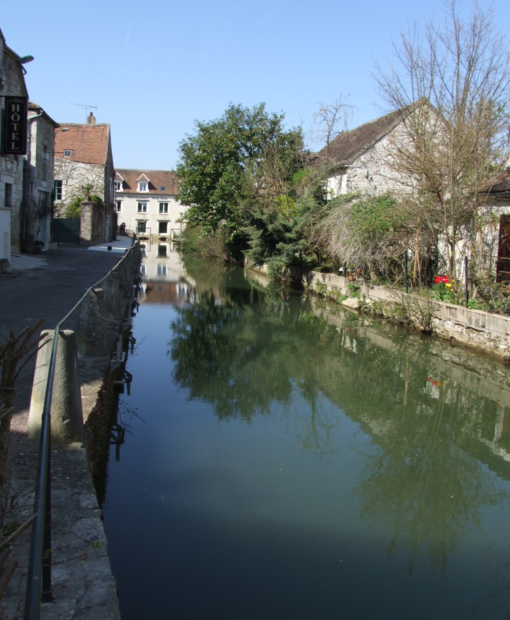
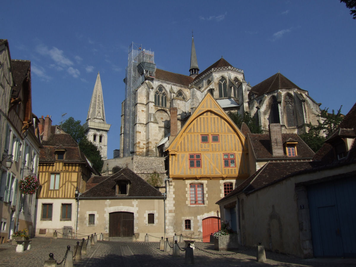
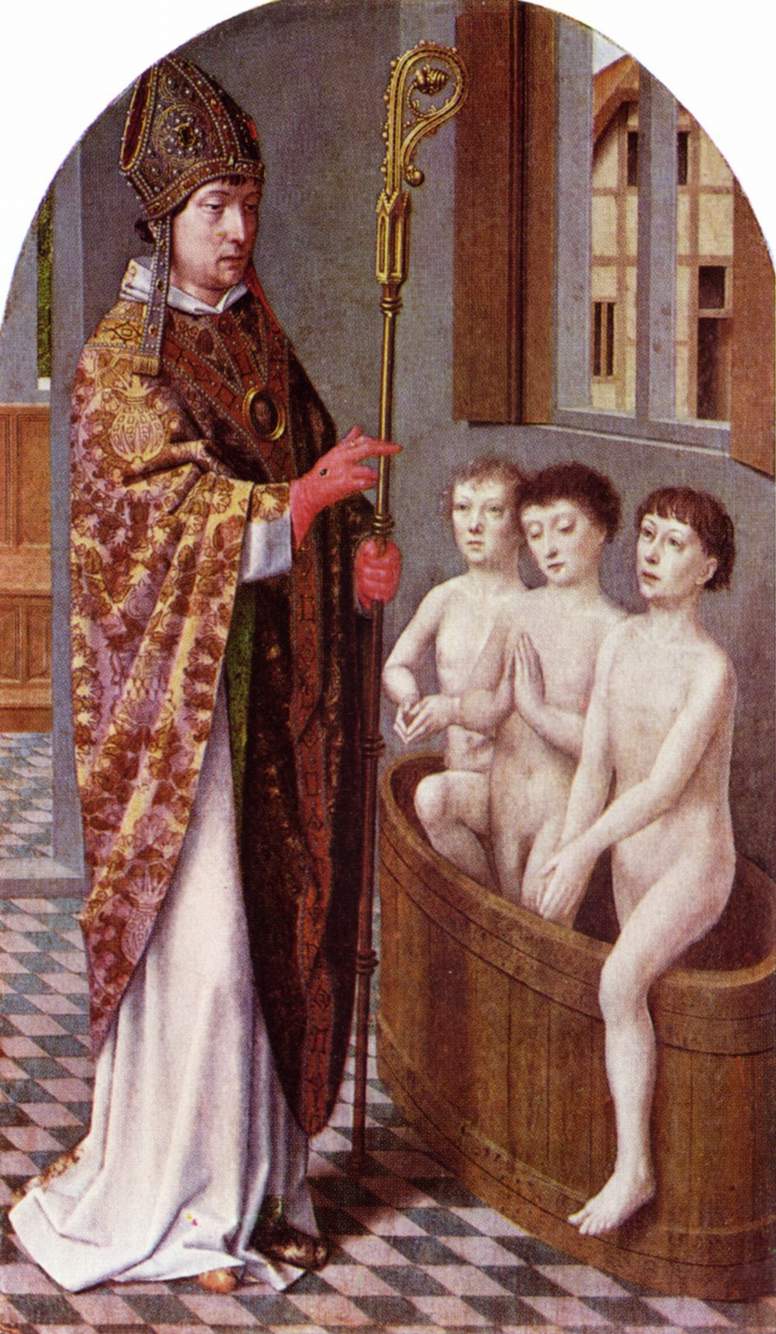
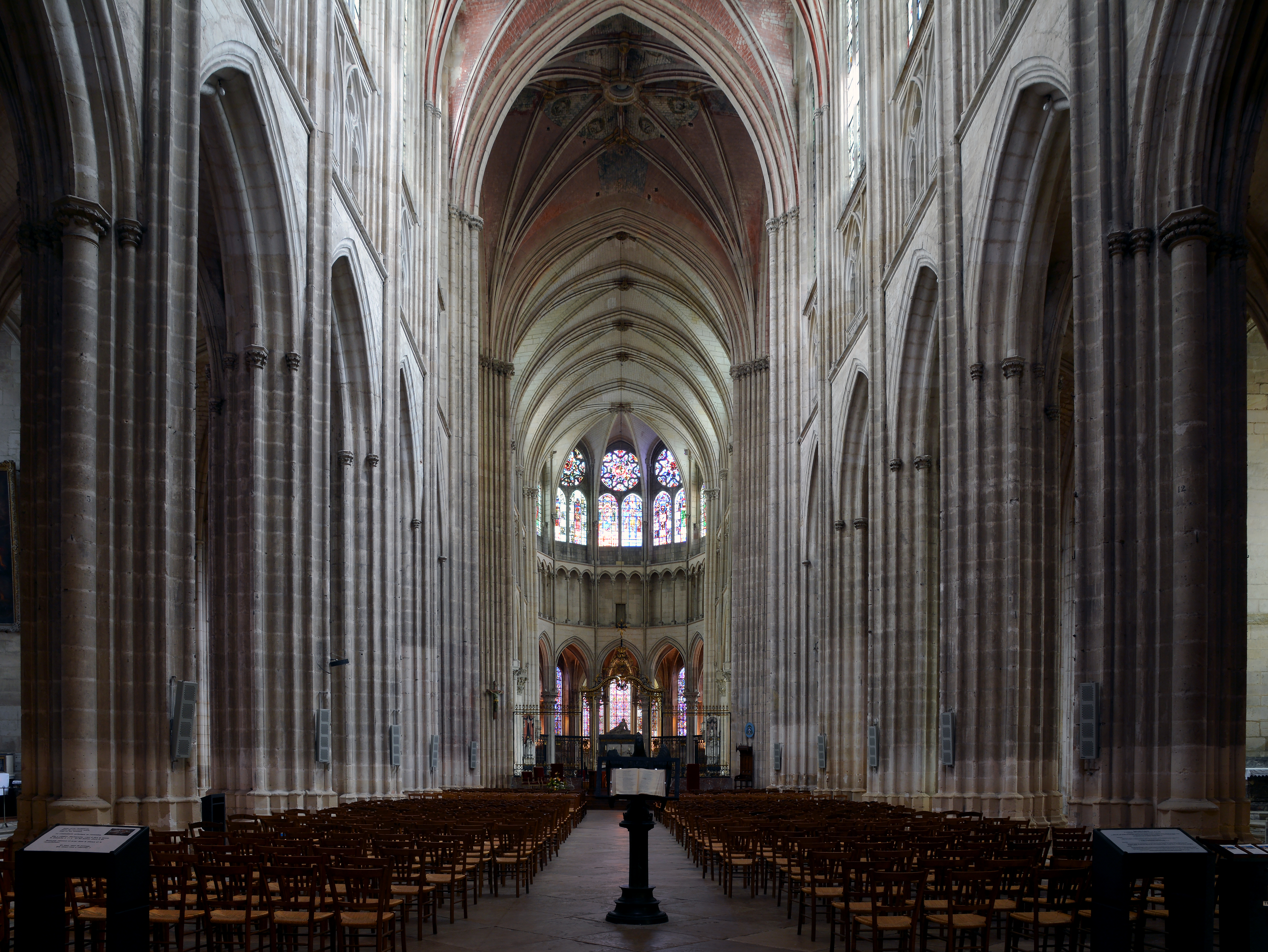
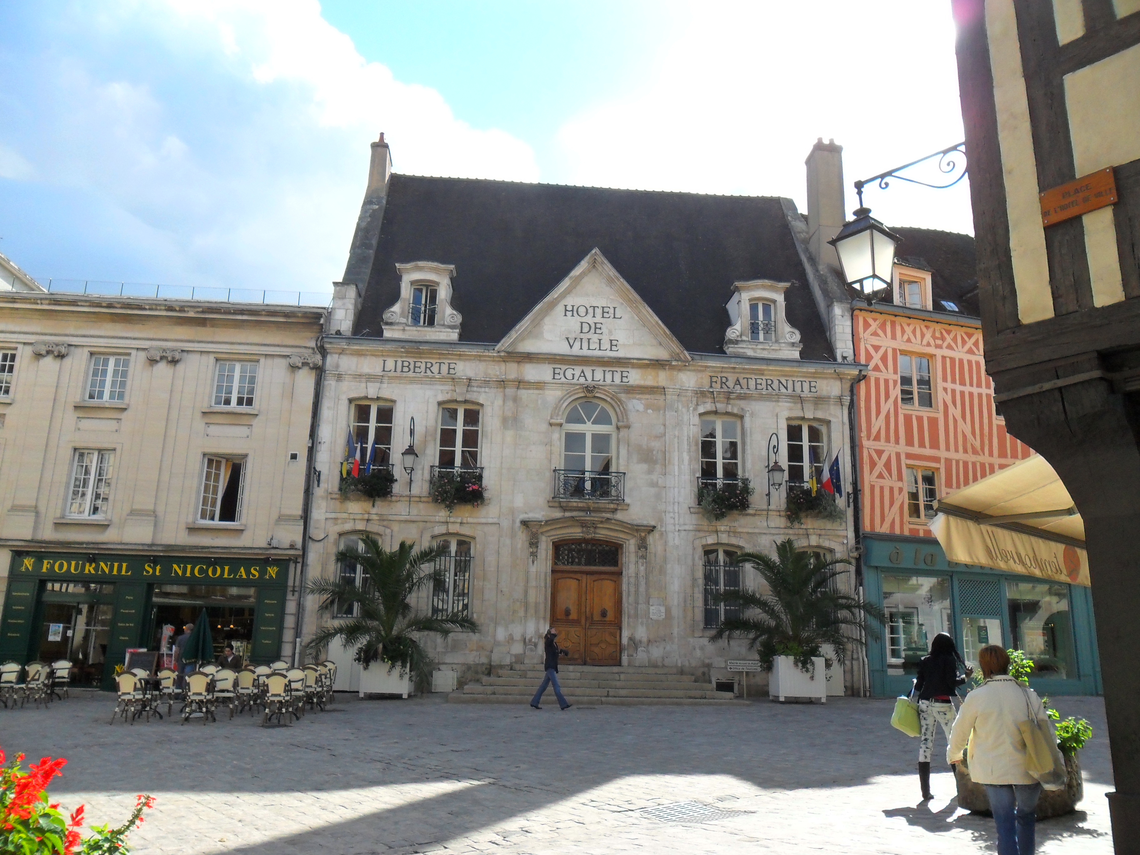
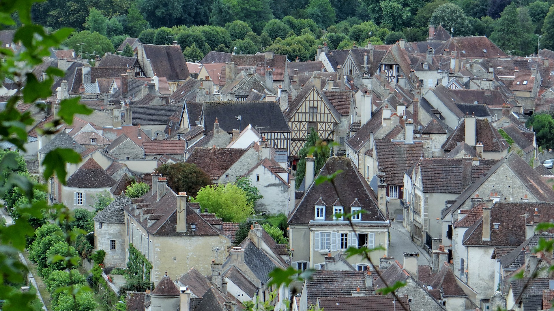
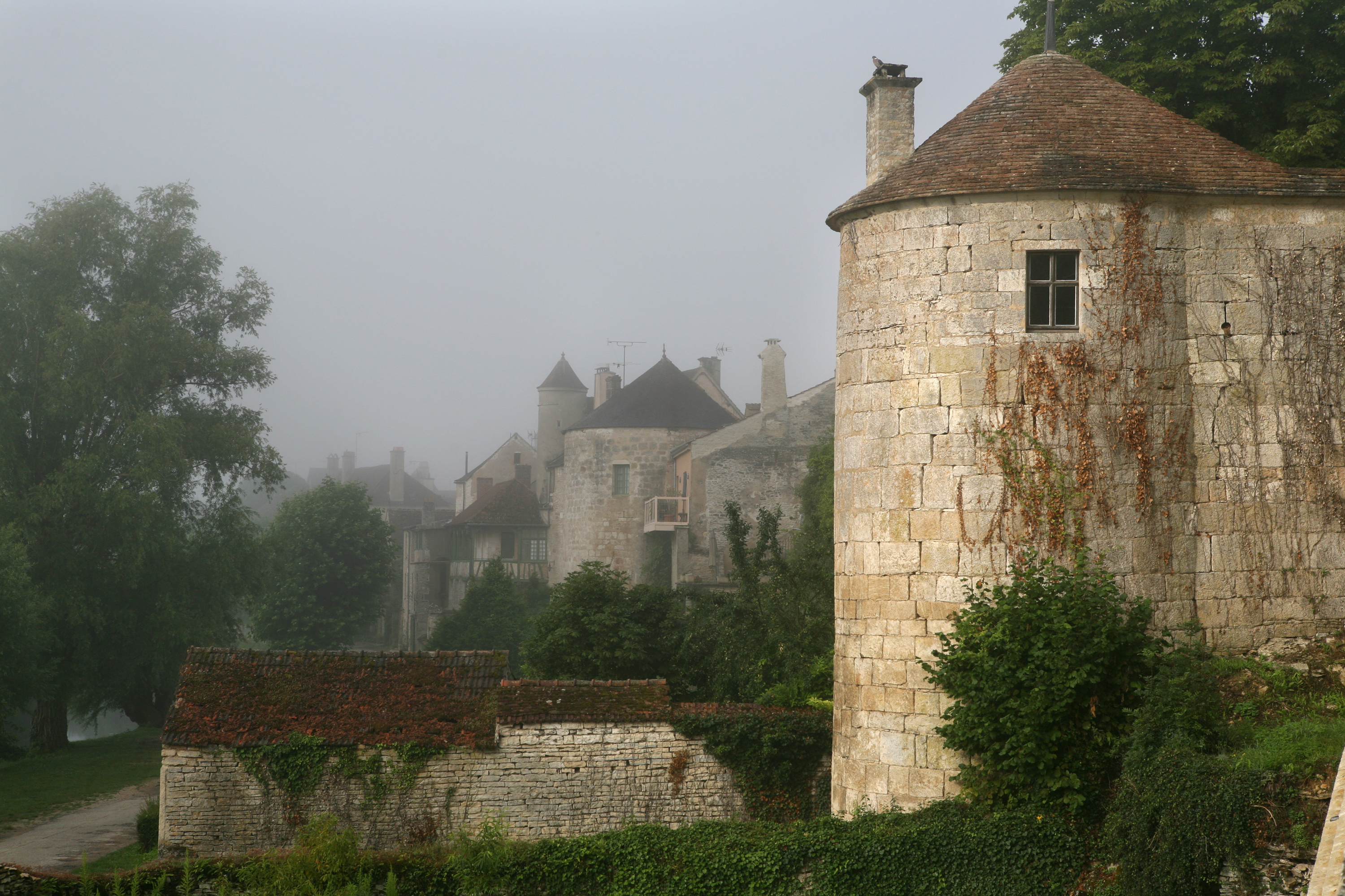
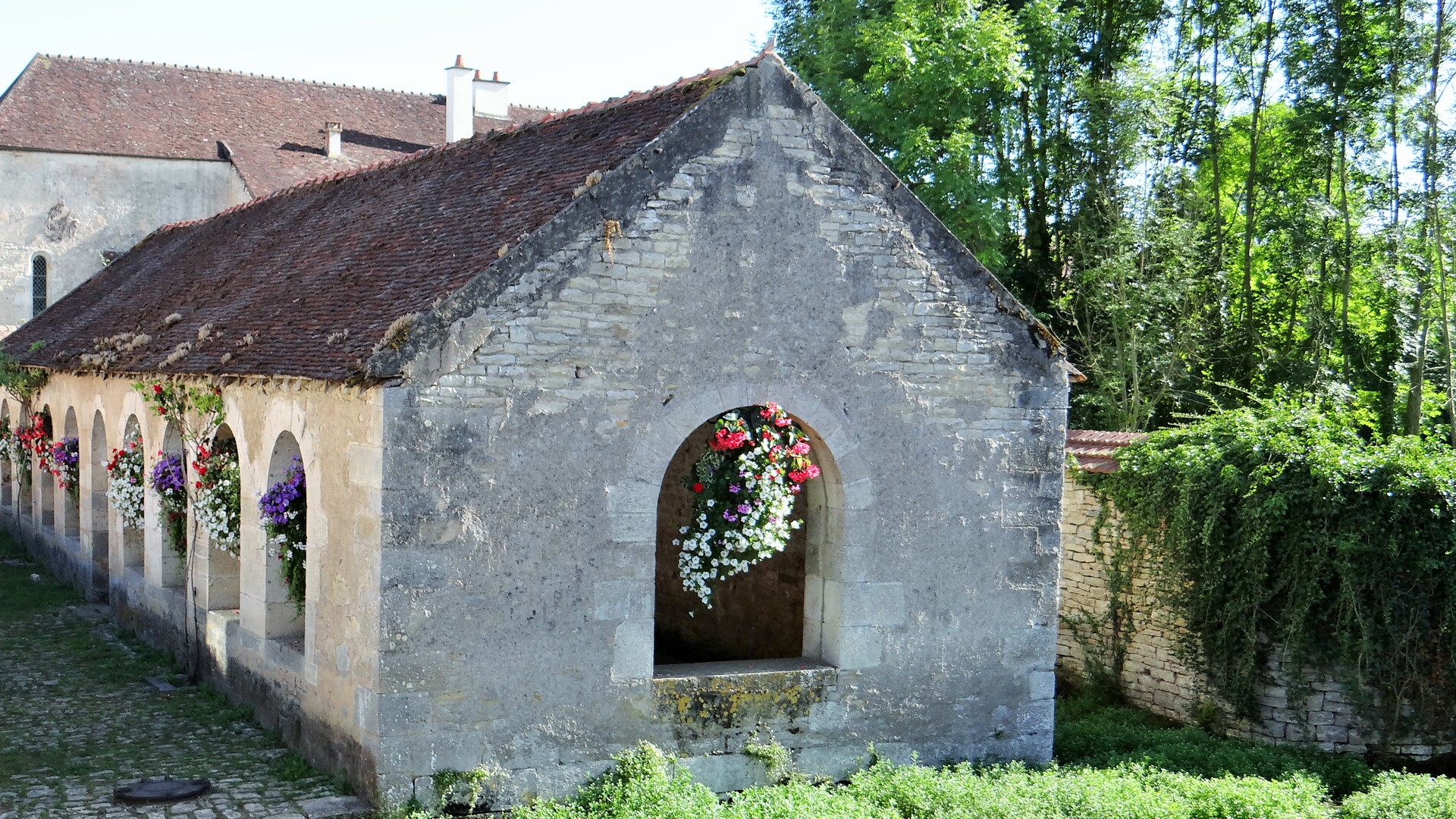
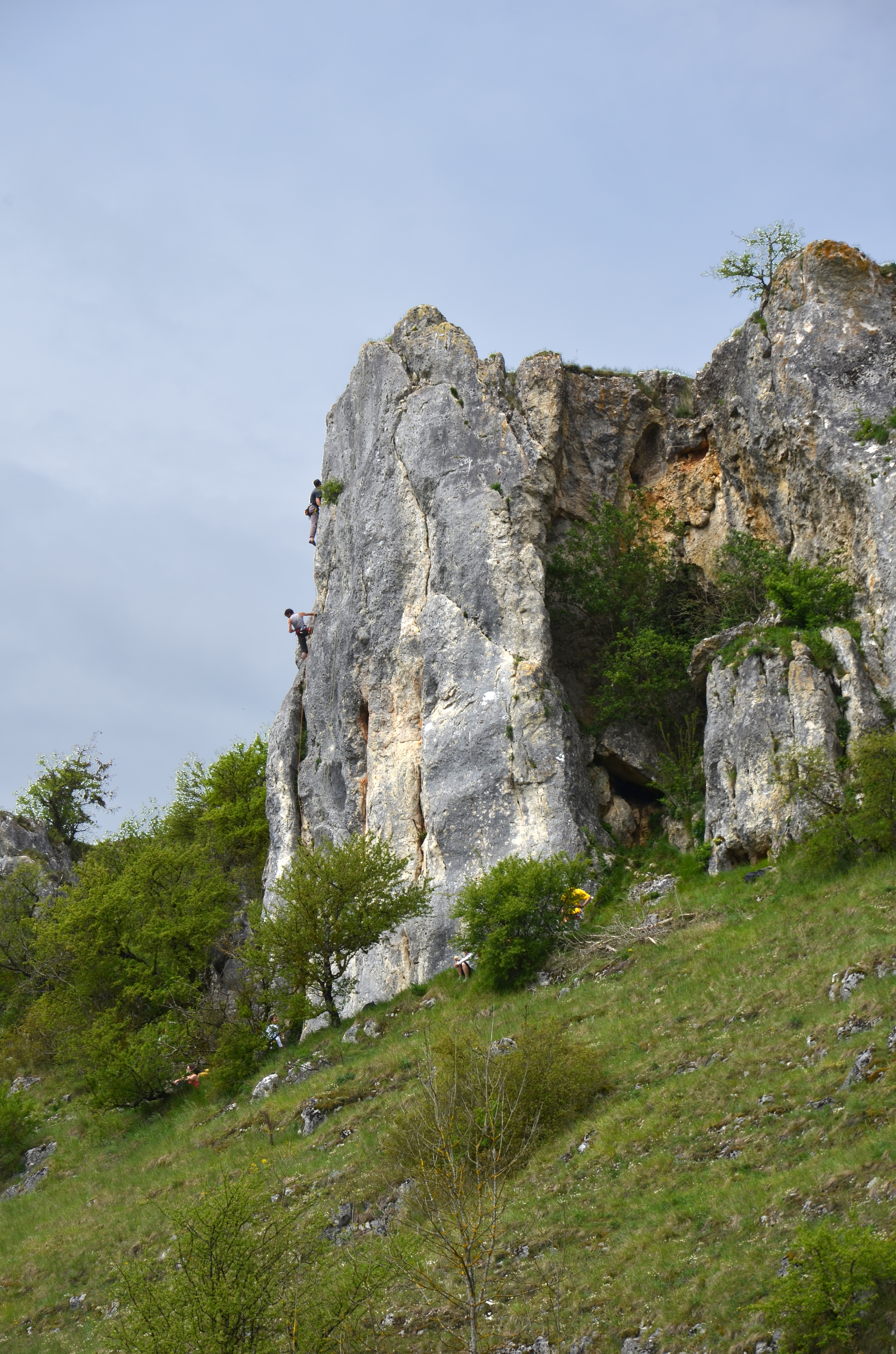
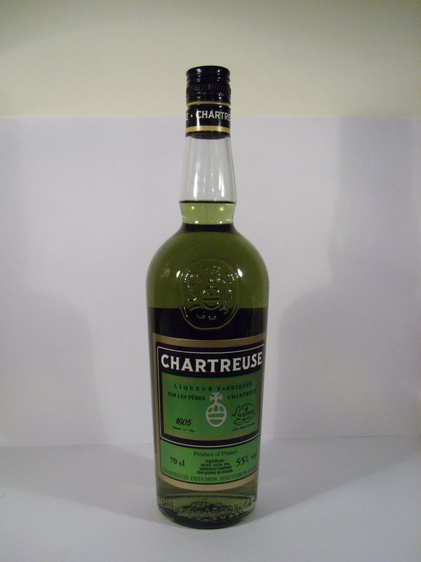
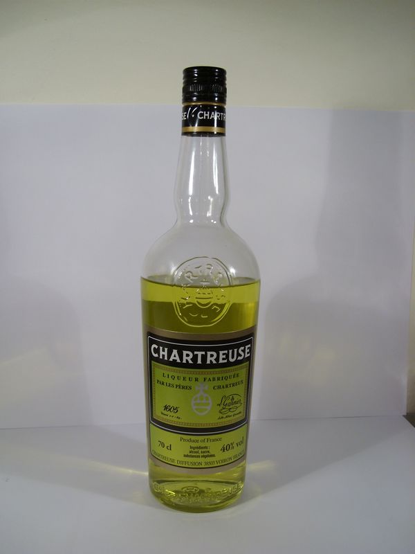