|
Reflections 2018
Series 3
May 1
Intermezzo IIb: NYC's Expansion Grid 2
| | The Manhattan story so far is this: the streets in the lowest part, below Houston Street, traditionally either conformed to nature or were developed into mini-grids in small neighborhoods. The Commissioners' Report of 1811 imposed a rectilinear grid on the island running east-west between 1st to 155th Streets with widely-spaced perpendicular alphanumeric avenues running north-south. Though imposed north of the New York City of that date plus the independent Greenwich Village, there is in practice a transitional area between Houston and 14th Streets, 14th being the first of the numbered streets to run river to river. North of 155th Street, more mini-grids were added to complete the street patterns to the north. Marble Hill was cut away by the Harlem River Ship Canal and attached to the Bronx. We saw how the expansion grid obliterated the original location of Harlem, which was along the Harlem River, all the villages of the Bloomingdale District on the Upper West Side, and most of Manhattanville, except for two streets. | | | | We saw how those two Manhattanville streets became grid variations, since they were grandfathered into the grid, as were most of two long roads. The Wickquasgeck Native American Trail had run from the bottom to the top of Manhattan, and the Bowery and Broadway (Bloomingdale Road) seemingly took turns in following it north to the King's Bridge, either in the guise of the Eastern Post Road (Kingsbridge Road), the extension of the Bowery, or of the Western Post Road (the extension of the original Broadway). There are still the remnants of two more very interesting streets grandfathered into the major grid (plus one more way uptown), so we'll now complete the summary by discussing Astor Place and Stuyvesant Street, then move on to how the master grid of the Commissioners' Plan ruthlessly plowed under most of the natural areas of Manhattan. But be sure to realize how that which had once been is often still to be found, just hidden in plain sight. | | | | Astor Place & Stuyvesant Street The two seem to come together as one, kissing face-to-face. But they were never one single street, and each arrives at their common intersection at its own odd angle from the grid. Furthermore, each is the stub end of a longer street, the balance of each of which the Commissioners mercilessly plowed under. Yet when our two streets originally came together to form a plus (+) intersection, it was with the oldest street in Manhattan, the part of the Wickquasgeck Trail that became the Bowery. Before we look at the maps that will tell us so much, first picture that intersection back in the day, centuries ago. The bottom of the + is the Bowery. So is the top, though it's the part of the Bowery now ignominiously called 4th Avenue. The two streets that joined at the Bowery were these. The left arm of the + is what is now called Astor Place, and the right arm is Stuyvesant Street. Picture that intersection in your mind.
https://moon.com/wp-content/uploads/2015/08/01_03_EVillage_LowerEastSi.jpg
| | | | We are going to tackle this curious, captivating intersection and its surrounding neighborhood backwards. First look at the above modern map (hold on to it) of what has come in recent decades to be called the East Village, though it really has nothing to do with Greenwich Village. Clicking on the upper part of the map, you'll see we're in the transitional section between Houston and 14th Streets. Although we'll discuss the border between the numbered and named streets later, we can say for the moment that the eastern part of the border runs west along Houston, turns north at the Bowery, then turns west again at Astor Place. But more later. | | | | | | You can't say that Astor Place is grandfathered, since it existed already at the very edge of Greenwich Village, with new numbered streets added around it. However, Stuyvesant Street IS grandfathered, since it's in yonder territory, lost in a sea of numbered streets and avenues. This is one indication that we're at the border between the new grid and the original NYC+Greenwich Village. |
| | | | On this somewhat simplified modern map, Astor Place runs for two blocks, from Broadway past Lafayette Street to the Bowery (4th Avenue). In actuality, part of its eastern end is pedestrianized as it meets the Bowery. Stuyvesant Street then also starts with a pedestrianized section, a larger one, but then runs for a couple of blocks to 10th & 2nd, with its eastern end in front of a church (#6) also being pedestrianized. We show this current map because it indicates that there are two grandfathered streets there, though they don't seem to meet at the Bowery (as they once did). The fact is, 20C traffic has made the history appear vague, since cars can no longer run the full length along both streets and traffic on these two streets are shunted off onto numbered streets. In addition, all streets here are one-way in this modern world. However, streets are still a pedestrian milieu, and cars aren't the way to define history. Anyone can walk the full length of the two streets, from Broadway, across the original intersection at the Bowery, and on to 2nd Avenue, which I've done in the past.
http://gvshp.org/blog/wp-content/uploads/2011/02/Untitled-13.jpg
| | | | What we need is a somewhat older—though not yet ancient--map, such as this 1897 "red" map from the New York Public Library. Look at the Bowery (4th Avenue) being crossed by these two streets, and you'll still see the original intersection dating centuries before. I would imagine traffic at this date could still travel the length of both our streets as it had been doing for generations. A great thing about this map is that it shows Astor Place beginning at Broadway, but blue lines indicting that it used to be longer and came from somewhere else. Also look at the east end of Stuyvestant Street in front of the church, with indications that that street continued much further east beyond 2nd Avenue. And, while I'm greatly in favor of pedestrianized streets as being the height of modern urban living, I'm glad that this map shows none of the pedestrianized blocks to confuse the historic facts. That includes the now pedestrianized block in front of the church. The actual four-way intersection has been reconfigured to be part of 8th Street, and is also pedestrianized. Our two "kissing" streets now seem to be estranged. Vehicles have about a two block gap between them, as the modern map shows. It's a shame. It's good you can still walk the entire distance of the two streets. Notice the craziness of the imposed numbered streets and avenues over the grandfathered streets. Also, something to note for later is that Lafayette Street doesn't exist yet. Instead there's a very short street called Lafayette Place (only "PL." is visible). | | | | Astor Place The upshot of all this is that, with the passage of time, this ancient intersection gets more and more obliterated, and fewer and fewer people realize, in the tangle of newer and older streets, that it ever WAS an intersection. But we do, and so let's start with Astor Place. Of the two streets, Astor Place has to be the older, since it, like the Bowery (Wickquasgeck Trail), was once a Native American Trail, leading cross-island from what is now Greenwich Village right up to the WTrail. Let's start by looking at an older map still:
http://forgotten-ny.com/wp-content/uploads/2000/10/stuygarden21.jpg
| | | | We've moved from a map of today, back to 1897, and now to about a century earlier. We'd estimated that ur-Broadway-2 was extended between 1776 and 1815, and this map shows it just reaching what is now Astor Place, but not yet going beyond to Union Square, so let's estimate this as showing the 1790s. We see the Bowery coming north to the intersection, then continuing beyond (today called 4th Avenue). We see on the right the Stuyvesant bowery, with what is now Stuyvesant Street (see below) entering the intersection from that side, to meet Astor Place. And we get our first clue as to what Astor Place is the stub end of, Sand Hill Road, running well east of even Broadway. To see where it came from, let's move west and again start with the present, then move backwards.
https://moon.com/wp-content/uploads/2015/08/01_02_WVillage_Soho.jpg
| | | | This is the present-day map of Greenwich Village and Soho (hold on to it) that we studied along with the Bayard estate. But as we look at the Village street patterns, we find that much is parallel and perpendicular to the Hudson, but then others bend and twist. But look at the top, where the Village originally ended, and you'll see an inverted V, which I call "the Gable", as though it were at the end of a roof. You can see that north of this Gable there are nothing but numbered streets, so we see that, just like Astor Place, we're on the border of the original Greenwich Village. It won't be a surprise that today, 14th Street is considered the border, but we know all this is in the transitional area, with both named and numbered streets. Click to see the streets that form the angle of this Gable: Gansevoort Street and Greenwich Avenue. Gansevoort, by chance, is exactly where the High Line begins, though once, the Hudson River RR went much further south. (To review our most recent discussion of the High Line and the Meatpacking District, see 2017/8.) | | | | Gansevoort Street was once called Great Kiln Street, for a lime kiln located there, and then was named for Colonel Peter Gansevoort, a hero in the Revolutionary War. As for Greenwich Avenue, we referred in the previous posting to two streets with similar names. Look three streets in from the river to find Greenwich Street, which leads here from the Battery. It was the connection from early New York out to Greenwich in the countryside. The other is Greenwich Avenue, which forms the other side of our Gable. It's one of the very few older streets in Lower Manhattan called an "avenue"; I speculate it's in order to distinguish it from Greenwich Street. | | | | Notice that our two Gable streets no longer connect, though they once did—but that break between them was the Commissioners' doing when building the grid. That makes Greenwich Avenue seem to begin nowhere, and also end nowhere. This is the sort of thing that should make anyone suspicious when looking at the modern map. | | | | We have two similar old maps of the Greenwich Village area, but each emphasizes things the other doesn't, so we'll look at them both. We first discussed the Bernard Ratzer map in 2011/2. This is a circa 1760 detail from it of the area that was to become Greenwich Village. You see at the bottom things we discussed in the last posting, such as the De Lancey and Bayard properties, and Collect Pond. You also see "The Bowery Lane" (The Bowery) leading north. Along the Hudson we see the "Road to Greenwich" (Greenwich Street), right on the water, before landfill was added, locating it two blocks inland today. Not only do you see how close the Greenwich Village area was to the growing New York, you can see the "country" homes that Oliver De Lancey and William Bayard had. And my, my, my, doesn't that seem to be an ancestor of Gansevoort Street between their properties! | | | | | | In the 16C, the Lenape referred to the habitation site and cultivated area by the cove on the Hudson at present-day Gansevoort Street as Sapokanikan ("tobacco field"). In the 1630s, the Dutch settled there, but two names have come down to us. Because of its location north of Nieuw Amsterdam, one name was Noortwijck (-wijck rhymes with vac[ant]), the equivalent of "North District" and similar to Northwich/Northwick). The other name was Greenwijck ("Pinetree District"), which is the name that has come down to us, since after the British takeover, it was anglicized to Greenwich, which, by pure chance, was also a familiar English place name. Later, "Village" was added to the name. So Greenwich Village, whose name seems quintessentially English, was originally Dutch, yet so similar to English that the alteration was minor. I find this amazingly similar to the point made in the previous posting, where the Dutch name Brede Weg was so easily taken over by the British because of the number of streets in England already named Broadway. These are just more examples of the similarity of English and Dutch, both being West Germanic languages. |
| | | | On the map, what is now Gansevoort Street met, at a sharp angle (a piece of which is missing today) the road the Dutch called the equivalent of Strand Road, which the British renamed Monument Lane (see map) in 1762, since it led to a long-gone British monument to Wolfe, who died in Quebec. The monument can be seen beyond the north end of Monument Lane. After the Revolution, Monument Lane was renamed Greenwich Lane, and is today Greenwich Avenue. These are, though among the oldest existing roads in Manhattan, since originally they were part of a Native American trail leading southeast and east from Sapokanikan. Now look one last time at the map, and see where the trail crossed a stream and swung beyond it as Sand Hill [Road], seen on an earlier map, to where Astor Place is today (Broadway doesn't exist yet), ending at the Bowery, facing Stuyvesant Street. | | | | Dating from a few years later, 1776, is this colored map. Click to concentrate on Greenwich Village, where the former Monument is more clearly seen; perhaps so is Sand Hill Road. This is the missing link. Gansevoort Street and Greenwich Avenue (Monument Street) mostly remain. Sand Hill Road became Art Street before becoming Astor Place, but only the last two eastern blocks of it remain. The entire middle stretch was obliterated by the Commissioners after 1811. Since this middle stretch looks like a cable hanging between two posts, that's what I call it. So from the Hudson we have the Gable, then the Cable. | | | | And we can find where it was. Go back to the present-day map of Greenwich Village above, the one that shows how the grid impinged just slightly upon the top of our Gable. Follow Greenwich Avenue to where the missing link would have been. You see 8th Street. This is NOT it yet, but follow it to the right of the map. The angular street you see just below it is Astor Place (unnamed). Picture our Cable hanging between the two, since the end of our road is Astor Place. | | | | But we can do better. 8th Street and higher are the first streets to validly cover new territory north of the old border. But what COULD have been 7th Street here (but never was) is now called Waverly Place, split by Washington Square North. It's safe to say that our Cable ran down to, then up from Washington Square North at about the foot of 5th Avenue, a lovely location. It's my opinion that this is the other place where the Commissioners impinged new streets on old territory. They did this by squaring off the block south of 8th Street to fit nicely along Washington Square, but thereby obliterating the historic Lenape trail we're calling the Cable. | | | | | | For the sake of completeness, we can mention now that the border between the Old (names) and the New (numbers) then bends sharply at Astor Place to continue south on the Bowery, making the southwest corner of the intersection we're studying the northeast extremity of old Greenwich Village. The route then turns from the Bowery east along Houston Street (the North Street of old New York) to the East River. This last section takes the form of the letter L, and for that reason, I use Gable-Cable-L as a reminder of the three sections of the border, to trace the line river-to-river. More below. |
| | | | Let's return to Astor Place proper. We talked in 2008/20 about John Jacob Astor when we visited Astoria, Oregon, and how he made his money in furs in the Pacific Northwest, and later in Manhattan real estate. We've mentioned him again recently regarding his real estate ventures, especially buying Richmond Hill from Aaron Burr's creditors after 1807. Another major venture of his involves the street named after him. In 1803, when New York above Houston Street was only just developing, Astor bought a large tract that included what is now Astor Place. In 1826, he carved out an upper-class neighborhood from the site. The feeling was that the angularity of Astor Place lent a ceremonial air to the intersection, especially as traffic at that time could continue right across the Bowery to the other angled street, Stuyvesant Street. | | | | He laid out, and had cut through, an elegant three-block street called Lafayette Place (NOT today's Lafayette Street), as shown on the above 1897 "red" map. It was a boulevard 100 ft (30.5 m) wide with no cross streets that began at Astor Place and ended at Great Jones Street (= 3rd Street). Although the elegance long ago disappeared from this neighborhood, a look at the above map of the East Village will still show two huge blocks still existing south of Astor Place, which have since only been crossed by 4th Street. Lots on both sides of this Lafayette Place sold briskly and at many times what Astor had paid for them. He became America’s first millionaire and at the time of his death in 1848 was estimated to be worth some $20 million. Astor Place was renamed for him soon after his death. | | | | We'll return later to see what changes contributed in the early 20C to the momentous decline of this elegant neighborhood, which unfortunately included subway construction. In any case, when the first subway line came through here, there was a stop at Astor Place. I doubt the subway builders knew how this intersection dated back to two Native American trails, yet it's appropriate that it remains a transportation hub. Much more attention was given to Astor himself, since this first subway line famously had faïence plaques commemorating each stop, and the one at Astor Place station has plaques of beavers (Photo by Gryffindor, cropped by Beyond My Ken) dating from 1904 as a tribute to John Jacob Astor, whose fortune was founded on beaver-pelt trading. | | | | | | We cannot in good conscience leave Astor Place without discussing the Astor Place Opera House and, more significantly, the Astor Place Riot connected to it. The Opera House was located on the east half of the block between Astor Place and East 8th Street, with the new Lafayette Place at the east end (do find this location on the "red" 1897 map marked "Mercantile Library"). The Opera House opened in 1847, and this illustration is from 1850. It was planned that the Opera House would attract only upper-class patrons, so, with their comfort in mind, benches, the normal theater seating at the time, were replaced by upholstered seats, available only by subscription, as were the two tiers of boxes. Lower-class patrons were admitted, but segregated in a balcony area with benches, reachable only by a narrow stairway. This was an attempt to avoid the rowdyism that plagued other theaters at the time, especially in the adjacent entertainment district of the Bowery. But since the Opera House couldn't thrive just with opera, it was also used for theatrical performances.
It's hard to imagine that people would die based on which actor played the better Macbeth, but that's just what happened. The real problem was class differences, appearing as Anglophiles versus Nativists. For a long time, the English actor William Charles Macready and the American Edwin Forrest had been touring their own, and each others' countries, and each had huge followings. Upper-class Anglophiles tended to support Macready, and lower-class Nativists, including many Irish, tended to support Forrest. Theaters were the main gathering places in cities and towns, and star actors had loyal followings. They were the celebrities, the sports figures, the rock stars of the day.
On 10 May 1849, Macready was scheduled to play Macbeth at the two-year-old Opera House and Forrest was scheduled to play Macbeth at the equally two-year-old Broadway Theatre on Broadway and Worth, close to City Hall. Although there was plenty of trepidation, they were urged to go ahead with the performances anyway. It was a tinderbox situation, and a handbill such as this only made it worse. The riot broke out at the Opera House and left at least 25 dead and more than 120 injured. The riot marked the first time a state militia had been called out and had fired into a crowd of citizens, and it led to the creation of the first police force armed with deadly weapons.
The Opera House then gained a reputation as being "Dis-Astor Place" and the "Massacre Opera House", which it was unable to overcome. By May 1853, the interior had been dismantled and the furnishings sold off. The shell of the building was sold to the New York Mercantile Library--here in 1886. In 1890, needing more space, the Library tore down the opera house building and replaced it with an 11-story building (Photo by Beyond My Ken). The library moved again in 1932, and the building—gorgeous in my eyes—was repurposed several times, including for a while being the Astor Place Hotel. Since 1995, it has contained condominiums. Sic transit gloria mundi.
|
| | | | Stuyvesant Street The entire east side of the Bowery at our intersection was the Stuyvesant bowery/estate/farmstead, so we now need to look into that extended family, which, though the estate shrank over time, owned at least bits and pieces of it for over three centuries. The English pronunciation of the name stresses the first syllable and rhymes it with "sty". The founder of the dynasty in Nieuw Amsterdam preferred the Latinized version of his first name, Petrus, to the Dutch version, Pieter (English Peter, which we'll use). [Latinization was common during the Renaissance—look at King Gustav II Adolf of Sweden being called Gustavus II Adolphus.] Of all the family members, the other most important one for our purposes was his great-grandson and namesake Petrus/Peter, so we'll need to distinguish between the 17C Peter Stuyvesant, who we'll call the elder, and the 18C Peter Stuyvesant, who we'll call the younger, realizing however that there were three full generations between them. | | | | | | I was able to get more genealogical details from the Stuyvesant family tree:
Peter S (elder), 1610-1672 had two sons.
The younger was Nicholas Willem S, 1648-1698.
His only child was (Peter) Gerard S, 1691-1777.
His two older sons were Peter S (younger), 1727-1805, and Nicholas William S, 1769/70-1833.
|
| | | | The elder Peter Stuyvesant was Director General of New Netherlands, and was therefore entitled to occupy Bowery No. 1, the largest and best of the farms that the Dutch West India Company had set aside for the its officers in the countryside well north of Nieuw Amsterdam proper. In 1651 he purchased this farm outright from his employers, along with part of Bowery No. 2 on its south side and a large tract of meadowland to the north, totaling over 300 acres (121 hectares). He and his descendents further expanded the estate, which by the early 18C reached its greatest extent. It ran east from the Bowery [Lane], by some reports roughly between today's 6th and 23rd Streets, though others say further in both directions, and others still, less. By 1660 he built a family chapel adjacent to his manor house, which is located at the present-day site of St Mark's Church on Stuyvesant Street. He spent the rest of his life on his bowery outside the city, died in 1672, and was interred in a vault under the chapel. | | | | This is the manor house on Stuyvesant's bowery at the end of what is now Stuyvesant Street not far from our intersection. Though it's gone now, a very historic event took place there. In this house, on 9 September 1664, Stuyvesant signed the treaty that surrendered New Amsterdam to the British, named a British governor, and renamed New Amsterdam New York. I would say this is one of the most historic locations in Manhattan, yet am unaware of any official designation declaring the site of the house as an official historic site.
http://forgotten-ny.com/wp-content/uploads/2000/10/stuygarden21.jpg
| | | | At this point we should take another look at this map of our intersection from earlier. We can see that, facing Sand Hill Road/Astor Place across the Bowery [Lane] is an entry road—call it a driveway--leading to Stuyvesant's house. This entry road is today's Stuyvesant Street. While the house was destroyed by fire in October 1778, Saint Mark's, the replacement of the family chapel, still stands on the north side of this former entry road. The continued existence of the church makes the walk along Stuyvesant Street just that more historically breathtaking. | | | | We need to take another look at this colored map from before, but this time, to concentrate on the Stuyvesant property. This map is dated 1776, so we're in the time frame of the grandson and both great-grandsons. Find our intersection, and you'll see the driveway to the family homestead and adjacent chapel. But at this date, the original house was inhabited by the grandson Gerard, Latinized to Gerardus, who would die the next year, and the house would burn the year after that. [We should not be surprised at this date of the use on the map of the "long S" in G. Stuyveſant, as discussed in 2011/22.] Peter's great-grandsons (Gerard's sons) had their own properties on the estate. Look slightly to the south for Nicholas (N. Stuyveſant) and to the north for Peter (P. Stuyveſant). It strikes one right away that Peter was a family leader. His estate was called, appropriately, Petersfield, and was at the end of a very long entry road affording the manor house excellent river views. | | | | With his father gone and the ancestral house destroyed by fire, it was the younger Peter Stuyvesant who made a decision to develop the Stuyvesant family lands by subdividing them, and where else but at the already existing private road leading up now only to the chapel. Before the Revolution, the De Lanceys had successfully developed their lands, and the Bayards did so after the war, in about 1788. So, also in 1788, in anticipation of the expansion of the city from the south, Peter (younger) laid out a grid of streets around, and oriented to, the already existing Stuyvesant Street, his great-grandfather's driveway, but extended eastward beyond the site of the destroyed manor house, all the way to the East River. Take a look:
http://bedfordandbowery.com/wp-content/uploads/2016/12/Bowery-valentine-1868.jpg
| | | | I was rather surprised that I was able to dig a map like this up, though it's small-scale and non-clickable, so look carefully. Start by orienting yourself to the Bowery [Lane] on the left. The proposed streets are in black, and are oriented due east-west and due north-south. This mini-grid is nine by four blocks, and was meant to create a village on the Stuyvesant estate, one that eventually got to be called Bowery Village, a 19C outpost of the City. Now tilt your head to the right to inspect the red grid with its numbered streets and avenues, and you'll see what the Commissioners actually imposed on this area. | | | | Notice the proposed family names for these streets. Judith was the name of the wife of Peter (elder) and also of the wife of Gerard, in other words, Peter's (younger) great-grandmother and mother. It was also his sister's name. Nicholas William (Willem) was the name of his grandfather and brother. Careful inspection of the map will also show the familiar names Gerard and Peter. Margaret, Cornelia, and Eliza (Elizabeth) were his sisters. Talk about keeping it all in the family! | | | | But of all these proposed streets, only Stuyvesant Street was actually laid out, since it had been the driveway, then extended to the river. Still, if today you stand at 2nd Avenue and 9th Street (the location of Veselka, a favorite restaurant), you'd have just about been at Judith & Nicholas William Streets if these had ever been laid out, and kept. | | | | The City's Plan of 1803, the plan prior to the Commissioners' Plan of 1811, actually did incorporate this mini-grid, just as it had done with the De Lanceys' and the Bayards'. However, as the 1811 plan was adopted by the City and as the City expanded, the earlier grid was superseded, with the exception of just the original driveway section of Stuyvesant Street, which was grandfathered into the new plan. You can tell that the Commissioners were adamant about the city line (which I call Gable-Cable-L). The De Lancey and Bayard properties were south of it, and therefore established. But the adjacent huge Stuyvesant property was "out in the country" and subject to the new rules. This despite that it was so close, nestled into the L of the city line formed by the Bowery and Houston (North) Streets, with even Astor Place being on the border. | | | | Before leaving the last map, note several things. Above "Quick Street" at the bottom you see a road called The Lane, which we recognize from the colored map as leading to Nicholas's house. Gone. At the top, near "Winthrop Street" is Petersfield Lane, winding its way to the Petersfield manor house facing the river, Peter's (younger) home. As you can see, it was located at today's 16th Street east of 1st Avenue. All gone. On Stuyvesant Street you see in green the church Peter (younger) built in place of the family chapel—the church is preserved today at the cut-off eastern end of Stuyvesant Street. You can see the site of the ancestral manor house on today's 2nd and 11th, along with a family cemetery across the street. Both of these are gone. The Commissioners were relentless in destroying the past in order to have as geometrically perfect grid as possible. It's a wonder anything from earlier history was grandfathered in at all. | | | | But there's a reason why the original driveway part of Stuyvesant Street managed to escape destruction, and that was because at that time, it had become a well-established and highly-trafficked thoroughfare. At the intersection, it connected with traffic coming from Sand Hill Road (Astor Place), plus north and south traffic on the Bowery [Lane]. Also, the part of Stuyvesant Street nearest the Bowery was developed--lots had been leased and buildings erected. This is most notable today on the stretch St Mark's Church is on. Actually, it's easiest to understand what happened by considering the extended street in three sections, east, west, and finally, central.
http://gvshp.org/blog/wp-content/uploads/2012/06/line-map.jpg
| | | | This map shows the lengthened Stuyvesant Street at its greatest extent, as originally laid out in 1787, but oriented to the modern grid. The red sections are gone. Only the blue area remains. | | | | | | While the lengthy extension east of the Church and manor house site is gone, its effects have not quite entirely disappeared.
http://www.manhattanpast.com/wp-content/uploads/2012/08/block440.png
https://pbs.twimg.com/media/DTNBrNsXUAAbLob.jpg
One full avenue east of what remains is the intersection of 1st Avenue and 13th Street, as in this map. The extended Stuyvesant Street once cut across the corner of this block, and a property lines defining a land lot were laid out according to it, most likely when everything else here was woodland. That lot remains to this day, though all the properties around it were later laid out according to the numbered streets and avenues. It appears that that lot, which remains to this day, has been given egress via 12th Street. If you're incredulous that subsequent buildings were built on that lot, check the aerial view in the second link. The red-roofed building complex is on this unusual lot, still aligned to the ghost of the Stuyvesant Street extension.
|
| | | | Let's next consider the western end of Stuyvesant Street. This was in good shape up to the 20C, when the increase of auto traffic came.
http://gvshp.org/blog/wp-content/uploads/2011/02/Untitled-13.jpg
| | | | This is the same 1897 "red" map from earlier. It's obvious that, until the 20C, the full two blocks of Astor Place connected across the Bowery to Stuyvesant Street. However, the newer 8th Street was already eating away at the historic intersection. So was 3rd Avenue, making it lose a lot of its individuality all the way up to 9th Street. All this is the other red section on the recent map. The remaining blue section really consists of the stretch between 9th & 10th, plus the short stretch in front of the church. | | | | And the 21C hasn't been any kinder. In the last couple of decades, the City has upgraded the area, adding parks and pedestrianized streets. That's great, but is at the expense of recognizing the former historic intersection. Here are the latest plans. On the left, the easternmost block of Astor Place is now a plaza, still bisected by 8th Street. It's even more obvious here how both 8th Street and 3rd Avenue have been cutting into the remainder of Stuyvesant Street. It appears that 4th Avenue (ex-Bowery) has been downgraded to less than a through street, letting 3rd Avenue take the brunt of traffic. At the bottom, part of it has been converted to a small park called the Village Plaza. Why "Village"? Do you think they can really be referring to the historic 19C Bowery Village that filled this area? I'm dubious. I'll again emphasize that you can still WALK along the entire remaining length of Astor Place plus Stuyvesant Street, but you cannot drive more than an odd block here and another there. However, someone has a sense of history, as this granite inlay in the sidewalk indicates, showing the east-west orientation of Stuyvesant Street.
http://gvshp.org/blog/wp-content/uploads/2016/03/20160321_092404.jpg
| | | | So let's concentrate on that central block-and-a-bit of the remainder of Stuyvesant Street, starting with the "bit", the location of St Mark's-in-the-Bowery, completed in 1799. It's been a religious site for over 3 ½ centuries and is the second-oldest church building in Manhattan after the 1764 St Paul's Chapel on Broadway. It was again Peter (younger) who sold the family chapel property to the Episcopal Church for $1 in 1793, stipulating that a new chapel be erected to serve Bowery Village, the community which had coalesced around the Stuyvesant family chapel. St Mark's was built of fieldstone, in the Georgian style. In my view, the most significant word in its lengthy name is "IN". Given that the church is several blocks from the street known as the Bowery, its name has nothing to do with the road, a point I'm sure is lost on most visitors. The reference uses the original meaning of "bowery", that is, "farmstead or estate" and refers to both the earlier Stuyvesant bowery and the later Bowery Village that developed around the church. It really is IN the bowery. And Peter (elder) is still buried in its graveyard. | | | | This beautiful scene including St Mark's dates from the 1840s (and do click!). If you've been picturing pavement on all our discussions of these and other streets, think again, since roads were rarely paved until the 1920s, with increasing car traffic. The location of the old manor house would be behind us here, that cart on the right would be coming out of the new 2nd Avenue, and that would be the new 10th Street on the other side of the church. We are looking due west (of course!) and the next block is the other full block that remains with us today, intersecting with 9th Street beyond. This is a contemporary view of St Mark's (Photo by Jim.henderson). I particularly like this next wintry view down Stuyvesant Street (Photo by Jim.henderson). We're again looking due west (!), with St Mark's on our right (click). We again see that this short bit of a block has been pedestrianized to connect the church with the tiny park to the left, further defined by 10th Street crossing ahead. | | | | Let's move ahead into that larger block to note that the church isn't the only historic focal point on the street. Peter (younger) had five houses built on the north side of Stuyvesant Street at the start of the 19C. The house at No 21 was built in 1803 (pre-Commissioners!) as a wedding gift to his daughter Elizabeth (remember the proposed Eliza Street), who married Nicholas Fish, a close friend and political ally of Alexander Hamilton. Their son was Hamilton Fish, who became New York State governor, senator, and secretary of state. It is now known as the Stuyvesant-Fish House (Photo by Beyond My Ken), made of brick, in the Federal style. | | | | | | It's worth mentioning here the length of Stuyvesant family ownership in this neighborhood. Part of Peter's (elder) 1651 purchase, mainly along the Bowery (including the renamed 4th Avenue section), remained in the hands of Stuyvesant descendants until the death of Peter Winthrop Rutherfurd Stuyvesant in 1970. This period of 319 years is probably the longest record of continuous family ownership in the city's history. |
| | | | One final thing requires speculation, but I think we can make an educated guess that might be accurate. Why was Stuyvesant Street built exactly east-west, so that the proposed development did the same? Part of the answer involves the fact that Peter (elder) had acquired Bowery No 1, and then part of No 2, and decided to build his house and entry road on the old dividing line between the two boweries, it being convenient to our intersection with the two Native American trails. But there's no reason for him to purposely lay out his driveway due east-west. What I surmise is that it was the surveyors for the Dutch West India Company who were told to divide up the area along what became the Bowery [Lane] into individual boweries. This area would have been a total wilderness then, and when drawing property lines east of the trail, why would they do anything but draw the lines east-west? And why wouldn't they put one of the lines at a landmark such as the meeting of two trails? Thus Peter's driveway happily fell into place to complete the fourth arm of our intersection, and Stuyvesant Street is the only street that tells the truth, where all the numbered streets tell lies. How's that? | | | | The Tilt Manhattan seems to tilt. It's doesn't really, but seems to. It all starts with the Hudson, which we consider flows south. Well, it also tilts, at its end. Look at this map of New York (Map by Julius Schorzman), which is oriented to the north. We can see that the Hudson veers toward the SSW, and so does Manhattan, rather starkly, actually. The so-called north-south avenues in Manhattan were not laid out north-south, but parallel to the Hudson and East River shorelines. The so-called east-west streets were then laid out perpendicular to those avenues. As it turns out, the Commissioners' grid, following Manhattan and the lower Hudson, runs at a 28.9° offset, or "turned" a full 32% clockwise off the true cardinal directions. NNE would be offset only 22.5° (half of 90° is 45°, half of that is 22.5°) so the offset is even greater than NNE). So-called E and W streets are called that out of convenience, since it's easier to say E 42nd and W 42nd rather than the closer (but still not accurate) WNW 42nd and ESE 42nd. It's the grid that tilts, but Stuyvesant Street defies them all and shows the geographic truth, which has been obvious on every recent local map we've seen. | | | | It's a problem for mapmakers—should they show Manhattan tilted or "straightened". Most maps put north at the top, as do most maps of Manhattan, such as this one. The entire Commissioners' grid, including around Central Park, is in its natural tilt. This is correct, but so very counterintuitive that many maps of the island, such as the full-length one we used in the previous posting, twist it around and put north at 28.9° to the left. Compare Central Park on the last map with this straightened view, the intuitive way that it "should be". You don't notice the tilt in lower Manhattan, where the streets don't even begin to purport to point in the cardinal directions. | | | | Construction Northward We've seen how the Stuyvesant estate didn't have a chance to stop the northward laying out of the grid, with the following construction, and this continued uptown. There are numerous references in the names of neighborhoods to the ridge along the Hudson: Morningside Heights, Hamilton Heights, Washington Heights. But that's the ridge, which is relatively high, and still remains there. Now note the neighborhoods called Murray Hill (East 30s-40s), Lenox Hill (East 60s-70s), and Carnegie Hill (East 90s). Though some perceptible slopes may remain in these neighborhoods, the names testify to the former hillier nature of Manhattan island, much of which was flattened by the grid. Nature lost and rigidity gained. We'll now take a circular trip around the Manhattan grid to see how areas were affected.
https://1.bp.blogspot.com/-vp5bmWWX6DA/U05HXLmb3NI/AAAAAAAA5M4/POMFB9e-mwE/s1600/Maps+of+farms+commonly+called+the+Blue+book++18....jpeg+i.jpeg
| | | | In the last posting, at Union Square we came across the first map from the set of maps of farms commonly called the Blue Book, dated 1815, four years into the Plan. Above is another, covering the area of West Midtown known as Hell's Kitchen or Clinton. We see the former estates, farms, and streams that had the grid superimposed on them. The streets are numbered on the right from 37th up to 57th. Landfill hasn’t been put in place yet for 12th Avenue, so it starts with 11th Avenue on the left to 7th Avenue at the right edge, with Broadway (Bloomingdale Road) winding through the area with more bends than it has today. Broadway and 7th Avenue, roughly from 43rd to 47th Streets in the future would first become Longacre Square, then Times Square. Compare this map with this contemporary one of the Theater District (Map by PerryPlanet). Compare Times Square, for instance. | | | | Maps such as these also make clear why so many property owners were distraught about the arrival of the grid, and why some of them tried to stop the surveyors from completing their work. The maps are replete with houses that are directly in the way of where streets were scheduled to run, and properties that would be bisected, trisected, or completely obliterated by the streets and avenues of the new grid. No wonder people fought back against the Commissioners' Plan, or set their dogs on the surveyors. | | | | We now move to East Midtown and the Turtle Bay neighborhood in the 40s. I am absolutely delighted having found this picture of 2nd Avenue in 1861, looking north from 42nd Street. This is the first year of the Civil War. We learn from this picture that, as avenues were laid out, road builders did their best to level the road to avoid ups and downs. We see a lot of the bedrock Manhattan is famous for, and also can judge about some of the houses that were "saved", that is, not in the way of streets and avenues being cut through. While Saint Mark's-in-the-Bowery was fortunate to have numbered streets avoid it, do we really think this farmhouse was lucky? Lowering the streets left it high and dry on a cliff edge, reachable only by a stairway. One wonders how they got their horses and wagons up to the house, if they were able to at all. Were these homeowners really lucky? Let's compare this picture with East Midtown today (Map by PerryPlanet). Click to find 2nd and 42nd. Today the UN is one block east at 1st Avenue, the Chrysler Building (#4) is a short distance west on Lexington Avenue, opposite Grand Central. | | | | We now move to Uptown East to look at Mount Morris in Harlem. We saw the outcroppings of bedrock that had to be worked through. Some were left in midblock locations, with buildings later built around them, and these outcroppings were blasted away only many years later. But then, as man destroys nature looking for geometric perfection, every once in a while, nature wins. When 5th Avenue was extended north into Harlem, the massive, steep, rocky outcropping of schist (SHIST) called Mount Morris proved too much of an obstacle to clear (here, circa 1893—note the fire tower on the left). Instead, the stretch of 5th Avenue between 120th and 124th Streets was left undisturbed in 1836. In 1840, it became Mount Morris Park (today co-named Marcus Garvey Park), and traffic was routed around the park via Mount Morris Park West. Madison Avenue forms its east side. Check this out by clicking on the contemporary map of Harlem (Map by PerryPlanet). This is a contemporary, wintry view of Mount Morris Park, and the fire tower is still there. Nature wins! | | | | Don't rush away from that last map, but swing due left to look at Uptown West and Morningside Park. Here, a lengthy outcropping of Manhattan schist blocks 13 cross streets from traversing the park, built by Olmstead and Vaux of nearby Central Park on a steep cliff that effectively separates Morningside Heights—and Columbia University--above from Central Harlem below. Running parkside along the top of the cliff is Morningside Drive, actually an extension of Columbus (9th) Avenue, while Morningside Avenue runs below the cliff. The park lies between 110th and 123rd Streets, and the cliff rises so steeply that no cross streets can connect through it from below, thereby dividing 111th to 122nd Streets. Nature wins again! This is the cliff of Manhattan schist (Photo by Louis Waweru) looking southwest over Morningside Pond (see map) in the southern end of the park, with the back of the massive Cathedral of St John the Devine up above. | | | | We'll finish up our circle around central Manhattan by swinging down the Upper West Side from Morningside Heights. We can go down Broadway to reach our destination of West 84th Street (Map by PerryPlanet).
https://static.plive.co.ke/img/tech/origs6839136/8030482170-w980-h640/59414652c4adeecc688b55e9.jpg
| | | | At first, what we see on this 1879 picture looks just like what we saw in Turtle Bay. A road has been cut through quite deeply, leaving a farmhouse up on a rocky crag reachable only by a rickety flight of steps. But we know more about this long-gone building. Around 1830 the 216-acre (87-hectare) farm was acquired by Patrick Brennan and his wife Mary, with their children. A lot of research has shown me that, while we know the Brennan farm was located at what is today the northwest corner of 84th and Broadway, the rutted, dirt road (typical of the era!) that we're looking at is actually the side street, 84th. So we have to be looking west, toward the Hudson, and Broadway (which we know at this time was still Bloomingdale Road) is crossing 84th behind us. But there's still a lot more to this particular farmhouse, than meets the eye. Edgar Allan Poe lived here for two years with his family, and he wrote his masterwork The Raven here. | | | | Poe Before the Brennans Poe moved frequently between cities, such as Baltimore, Richmond, and Philadelphia, and also spent time in New York, though he changed residences very frequently. He and his wife Virginia, with her mother, first arrived in New York in 1837 and lived in Greenwich Village at 6th Avenue & Waverly Place, then at nearby 113 ½ Carmine Street. After a stay in Philadelphia, in 1844 they moved to a boarding house in the South Village at 130 Greenwich Street (at King Street).
| | | | Poe At the Brennans Poe's wife Virginia had tuberculosis and he was advised to move out of urban Greenwich Village to one of the farms along the rural Hudson, and so he found his way to the northern edge of Harsenville. In June 1843 the Brennans agreed to take them in as boarders in their farmhouse, an arrangement which lasted through the summer of 1844, since Poe was always moving around. I've discovered that he and Virginia had the double room on the south end of the second floor, with two windows toward the river and two facing inland, looking toward Bloomingdale Road. If you check the photo again, with south to the left, those two upper windows on the left were in the long-gone room where The Raven was written. I never knew before that it was written in Manhattan. [At the end of 2007/17, we had a brief discussion of the poem, where a Dutch friend challenged me to translate it into German. I just did the first verse.] | | | | | | Arguably the most famous line in the poem, repeated as such and in variations, uses an archaicism: "Quoth the Raven 'Nevermore' ". "Quoth" comes from the Old English infinitive cweðan "to say, declare, proclaim", which by Middle English became quethan, then died out. The OE past tense, 3rd person singular, was cwæð, which is the one form that survived over time, as "quoth", still meaning "[he] said, declared, proclaimed". A related word is "bequeath", which is simply the prefix be- plus cweðan. This yielded OE becweðan "to say, speak to", a meaning that died out. But the word also signified "to leave by will", the meaning that has survived. The noun form, "bequest", is also related. |
| | | | In later years, it was a couple of the Brennan children who wrote about Poe's time at the farm. He loved the natural look of the area, and was apparently fond of rambling down through the woods between the house and the river (straight ahead in the picture), and sitting for hours on the edge of the riverbank. There is a large rock still there today closer to 83rd Street, one block south, in what is now Riverside Park, which Poe called mount Tom, after a Brennan son. He would sit there silently for hours gazing out upon the Hudson. | | | | The reports continue that there was only one time when Mary Brennan was annoyed by her boarder. That was when she discovered he had scratched his name into her mantelpiece in his room. It was decorated with carved fruit, vines, and leaves, and Mary Brennan always kept it carefully painted a dark black. This one day, Poe was leaning against the mantelpiece and absentmindedly scratched his name in the black mantel. She called his intention to what he'd done, and he apologized. [Remember this mantel, and that it was black, black as a raven.] | | | | Actually, since he wrote the poem in this room, it shouldn't really be a surprise that the room in the poem was based on this Brennan farmhouse room. Notably, above the door was a small shelf nailed to the door frame that held a small plaster cast of the Roman goddess Minerva (Greek: Athena, often called Pallas, as Poe did in the poem). Behind the bust was a transom. | | | | When he finished the poem, he first read it to Mary Brennan and others. Then, on January 29, 1845, it was published in The Evening Mirror downtown at 25 Ann Street (near Park Row and City Hall), a newspaper where Poe worked as a critic. It became a popular sensation, making Poe a household name almost instantly. He became quite the showman, traveling around giving readings of the poem. We have a YouTube clip (3:02) of actor Dennis O'Hare as Poe giving a dramatic reading. If you're interested in (re-)reading all 18 verses, use this link:
https://www.poetryfoundation.org/poems/48860/the-raven
| | | | While at the Brennans', Poe came to appreciate the nature of Manhattan’s rugged terrain. He dreaded the coming of the grid with its destruction of the island’s natural beauty. He stated that "these magnificent places are doomed. . . . Streets are already 'mapped' through them, and they are no longer suburban residences, but 'town-lots'." | | | | Brennan Farmhouse Lost As the years went by, the Brennans moved from the old wooden house as development closed in. The rocky landscape that had enchanted Poe was being flattened out for new streets and avenues, and more and more buildings were appearing. On 18 July 1888 the New York Times, referring to the historic Brennan cottage, pointed out that its foundations were being shaken almost hourly by dynamite explosions, that construction from the west was almost at the cottage, and others from the east would be at it within the week, ensuring that the cottage would be demolished. The Times also pointed out that relic hunters had been at it for weeks, even as the crag below the cottage was being blasted away to extend the grid. We can now point out that the above 1879 picture of the Brennan cottage was taken about a decade before it was destroyed, and 35 years after Poe last lived there. The below picture shows the building that stands today on the northwest corner of Broadway (right) and 84th Street (left).
https://2.bp.blogspot.com/-3qNR2yJVytQ/WUeZzwQprnI/AAAAAAAAnRE/xHqI9h2ptq8z-KoRCLpTJy1xaARd-mGugCEwYBhgL/s1600/255%2Bw%2B84th.jpg
| | | | The Raven Mantel So much is now lost, but not quite everything. One of the relic hunters in the last days of the Brennan cottage was interested in the wooden mantel in the former Poe bedroom, the one Poe had scratched his name into, upsetting his landlady. The contractor charged him $5 for it and gave him a bill of sale dated 22 May 1888 attesting to its provenance. He first installed the mantel in front of which Poe wrote the famous poem in the library of his Brooklyn home, but in 1908, donated it, by then known as the Raven Mantel, to Columbia University, just up Broadway from the cottage's location, along with the documents attesting to its provenance. | | | | However, most of the mantel's time at Columbia was a total waste. In later days, no one there was sure what or where it was. Finally, a journalist researching it found it standing in a storage area on a mezzanine in Butler Library, surrounded by files, boxes, and exposed pipes. With the added nudging of the New York Times, the Raven Mantel was moved in 2012 to a more visible location in the rare book library at Butler, flanked by armchairs, with an oil portrait above it, as shown below.
http://untappedcities.com/wp-content/uploads/2013/10/Edgar-Allen-Poe-Raven-Mantle-Butler-Library-Columbia-University-University-Archives.jpg
| | | | Commemorations But there are other remembrances of Poe's time on the Upper West side. In 1980, the two blocks of West 84th Street from Broadway to West End (11th) Avenue (Photo by Taltal13) to Riverside Drive (at Riverside Park) were conamed Edgar Allen Poe Street to commemorate the time that he spent at the Brennan Farmhouse, and also exploring the area down to the river. The below plaque also commemorates Poe's time there.
http://assets.atlasobscura.com/article_images/10783/image
| | | | Poe After the Brennans Afterward, Poe continued living a transient lifestyle for the next couple of years. In 1845 alone, Poe also lived at 154 Greenwich Street, 195 East Broadway, and 85 Amity Street (which later became West 3rd Street). Early in 1846, he moved to East 47th Street in the Turtle Bay neighborhood we saw earlier. Shortly after that he made not only his final move in New York City, but his final move ever, to what was to be his final home. In May 1846, he leased a small c1812 cottage in the Fordham neighborhood of the Bronx (at the time it was Fordham Village in Westchester County) for $100 a year. Again, it was a move further into the countryside for the sake of his tubercular wife. He wrote several of his other famous poems there, including "The Bells", which is thought to have been inspired by the bell of nearby St John's College, now Fordham University, five modern blocks to the east. Virginia died in the house in 1847. Poe died on a trip to Baltimore in 1849, at which time his mother-in-law moved out of this final Poe residence.
http://thumbs.media.smithsonianmag.com/cms_page_media/2014/1/23/edgar-allan-poe-cottage-map.jpg.800x0_q85_crop.jpg
| | | | There is another Kingsbridge Road in the Bronx—this one leads from the old Farmers Bridge at Marble Hill east to the Fordham area, coming in on this aerial view from the left. Fordham University is down East 194th Street on the right, while Kingsbridge road bends around what is now Poe Park. The cottage was always on Kingsbridge Road, though originally closer to the bottom of the park, and had to be moved some 450 ft (137 m) north to its present location. I've visited this Poe cottage in the past. Since no one can visit the most notable of Poe's residences in Manhattan, I've at least made my personal connection to Poe in New York—in the Bronx. His wife's deathbed is still there. Here is a very rural-looking view of Poe Cottage today (Photo by Nicolaus.schmidt), though the photographer noted that, since the neighborhood is MUCH more built-up around the park than the picture shows, he had to climb a fence so he could carefully photograph it to create the proper historic mood. Bravo. Quoth the Raven "Nevermore". | | | | Objections to the Grid: Long Blocks Not only did the Stuyvesants and Poe grumble at what the grid was doing to Manhattan, there are numerous examples—most in plain sight—of objections to the grid. We can start with an obvious objection to the fact that the avenues were spaced so very far apart, forming unusually long east-west blocks, which some of us grumble about to this day when walking crosstown. But back in the day, there was enough grumbling that the Commissioners relented and added two north-south avenues to split up some of the wide blocks. They're today in plain sight, and anyone looking at a map of Manhattan can find two extra named avenues fitted in between the numbered ones, Lexington and Madison Avenues. Locals often shorten the first name to Lex, as when giving subway directions: "I came up on the Lex." Less frequently, the second one is shortened to Mad, as in the TV series Mad Men, since that street is today a center of the advertising industry. We can now show another page from the 19C Blue Book:
https://4.bp.blogspot.com/-Y1zVieuYViI/U05HX_tHRzI/AAAAAAAA5Mg/wxUkpGvj9Yw/s1600/Maps+of+farms+commonly+called+the+Blue+book++18....jpeg+k.jpeg
| | | | This page showing former farms and estates—and a stream—eradicated by the grid. It covers 53rd to 73rd Streets from 8th Avenue on the right to 4th (Park) Avenue on the left. Broadway is at the lower left having just crossed 7th Avenue, so Times Square would be just off the bottom of the map. But the point here is to note how on the right, Madison Avenue has been penciled in, just like the afterthought it is, between 5th and 4th (Park) cutting that long block in two. This is why I like to use, in addition to "short" and "long" blocks, the term "half-long" block to describe what Mad is shown doing here. | | | | The additional avenues were added in the 1830s and 40s, best explained using this map of the Gramercy Neighborhood (Map by PerryPlanet). Real estate developers had bewailed the long blocks, claiming they made selling mid-block property lots more difficult because of their relative isolation. At the bottom is 14th Street, which I describe as the top of the transitional area between street names. I find it also significant that the two added avenues were either adjacent to (as Lex) or starting from (as Mad) our two historic hubs, Union and Madison Squares.
| | | | Lex falls in what I call the "3 ½" position between 3rd and 4th (Park). Actually, Lex has three names. From Union Square (#6), move a half-long block east to the first name, Irving Place, running from 14th to 20th Streets, named after Washington Irving (discussed most recently in 2017/7). The developers then had a splendid idea to block through traffic on the rectilinear grid in favor of strolling pedestrians, and so Gramercy Park (#8) was set as a clever interruption of the grid. It's a fenced-in private park, paid for by residents facing it, who have sole access. However, this park lends it name to the whole neighborhood. As of 21st Street, the name Lexington Avenue finally takes hold, and continues to 131st Street. (The subway joins it only as of 42nd Street.) | | | | Mad was also successfully added between 4th (Park) and 5th Avenues, in the "4 ½" position. If you look at the map, though, you'll see that it wasn't practical to also start it at 14th Street, since the very historic section of the WTrail/Bloomingdale Road/Broadway already breaks up those long blocks. So Mad was laid out to start at 23rd Street, at our other hub of Madison Square (#7), from which presumably gets its name. It runs to 142nd Street. I understand that another added avenue had been proposed between 5th & 6th ("5 ½"), but was never built. Might Broadway's location again have been a factor? I don't know. It's interesting to think how Manhattan might look today if all numbered streets had each had an extra named avenue interpolated between them. | | | | | | Here's a thought most people don't think of. Broadway straightens out on the Upper West Side (Map by PerryPlanet) so that it runs parallel to the other avenues there. This happens roughly between 76th and 107th. In doing this along this stretch, it serves as a de facto "10 ½" divider between 10th (Amsterdam) and 11th (West End) Avenues. Note how much shorter these "half-long" blocks conveniently are as compared to others. Actually, even south of this, Broadway does the same block-shortening service down to Columbus Circle (and even beyond), serving in the "9 ½" and "8 ½" positions, though at its usual angle. There are really more "half-long" blocks in Manhattan than one would think. |
| | | | Objections to the Grid: Too Many Numbers Any inspection of the grid today reveals that there were few alterations of the east-west street numbers. Confusingly, three blocks in the mid-section of 8th Street, from 3rd to 2nd to 1st to Avenue A, have been renamed Saint Mark's Place. Not only does this seem to break up 8th Street, but the name reflects St Mark's-in-the-Bowery, which is a full two blocks away on 10th (and 2nd). Fortunately, the City has in more recent times used conaming, and not renaming, as with Poe and 84th Street. | | | | But it's obvious that parks beat out numbers in desirability. 59th Street is called Central Park South along the park, and 110th Street becomes Central Park North (west of that it becomes Cathedral Parkway near the Cathedral of St John the Devine. But the changes in names of crosstown streets are minimal. | | | | The story is quite different when it comes to objections to the alphanumeric system for avenues, where rejection was rife and where renaming avenues has been going on from the earliest days. Of the original avenues, only 1st, 2nd, 3rd, 5th, and Avenues C and D have never been renamed, neither in whole nor in part. I can't imagine Fifth Avenue residents along Central Park wanting to change the name, so full of cachet, to *Central Park East! That would have had its own cachet (see CPW, CPN, CPS), so such a change would have been a battle of cachets. It never happened. | | | | The plan for the numbered avenues actually started with 1st Avenue. Because of the irregular shoreline, any road east of 1st would be appearing in bits and pieces, which were to be lettered. The only place Manhattan was wide enough for this to happen completely was in the transitional strip between Houston and 14th, and that's why we have Alphabet City (Map by PerryPlanet), with room for all four, Avenues A, B, C, and D. (Note also Saint Mark's Place/8th Street.) | | | | | | The Spanglish version of "Lower East Side" is Loisaida. In recognition of Puerto Rican heritage in the area, in 1987 Avenue C was conamed Loisaida Avenue. |
| | | | North of Alphabet City we have what we could call "too many letters". No one uptown wanted streets with letters, so in Turtle Bay, one avenue east of 1st between 49th and 51st is not Avenue A, but ritzy Beekman Place, and from 53rd to 59th it's Sutton Place South, then Sutton Place. Continuing on the Upper East Side (Both maps by PerryPlanet) the name changes again to York Avenue for quite a distance, from 59th to 91st. After another break the street appears again in East Harlem as Pleasant Avenue between 114th and 120th. Avenue B fares no better. Two blocks east of 1st Avenue between 79th and 90th (see map) is not Avenue B, but East End Avenue. | | | | The first numbered avenue to be changed was 4th Avenue, and perhaps its change was the oddest. Only two train lines entered Manhattan, as we've seen. They were, on the West Side, the former Hudson River RR on a "street run" down 10th Avenue (mostly)—the only remainder there is the High Line. On the East Side there was what started out in the 1830s as the New York and Harlem RR, then became the NY Central, that ran down 4th Avenue via the Harlem station. The thing is, as hard as it may be to picture, the trains ran all the way down to City Hall, as you can see on this 1847 map. Click to follow the tracks down 4th Avenue, along Union Square, down much of the Bowery, turning onto Broome Street, to reach Centre Street and City Hall. It's hard to visualize street runs like that, with the smoke and noise. | | | | The part of the 4th Avenue rail run through the Murray Hill neighborhood between 34th and 40th Streets ran through an open cut, built in 1837. In 1850, these six blocks were roofed over and the tunnel roof was planted with grass, for which reason these six blocks were named Park Avenue in 1860, that name extended afterward from 32nd up to 42nd. But the noise and smoke eventually forced the city to cut the rail route completely, at 42nd Street, located then way out in the country (remember the Turtle Bay picture). That's where the original Grand Central Depot was built in the 1870s. Passengers wanting to continue south into the main part of the city would then take a horse car, and for this reason, the original Park Avenue Tunnel (34th-40th) was converted to vehicular traffic, which continues to this day (1,600 ft, 488 m long). This is vehicular traffic entering, at 34th Street, what was once a rail tunnel, and headed toward Grand Central (Photo by Beyond My Ken). | | | | But with the opening of the Depot, the railroad tracks between 56th and 93rd Streets were also sunk out of sight (a viaduct continues further north) and, in 1888, the name Park Avenue was extended north of Grand Central all the way to 135th Street, and then into the Bronx. Eventually, the line was electrified, ending the smoke and noise. The cinderella story of the change of 4th to Park is really quite unusual, since Park Avenue today rivals 5th for elegance. This view down Park Avenue (Photo by midweekpost) from 51st Street to Grand Central shows what puts the "park" in Park. | | | | In an attempt to spread that elegance, in 1959, 4th Avenue from 17th to 32nd was renamed Park Avenue South. 4th between 14th and 17th had already been renamed Union Square East, which means that all of the original 4th Avenue had lost its name. I don't know when the upper end of the Bowery from 8th to 14th was renamed 4th Avenue, but that is, of course, pseudo-4th Avenue.
http://excitingny.com/images/midtownnymap.jpg
| | | | But by far, the majority of avenue name changes took place on the Upper West Side (UWS) and Harlem, virulently rejecting numbers in favor of names. First let's look at this Midtown map (click) to see what avenues we're talking about: from the Hudson it's 12th to 6th. 12th is the oddball from the get-go. It's much more of a winding shore road than an arrow-straight grid avenue. It's northern end at 72nd Street (off the map) leads into the Henry Hudson Parkway, and most of its length it's also known as the West Side Highway, replacing the former elevated version that was above it. (We are also not considering the winding Riverside Drive on the UWS, which is also a shore road.) Look at the lower end of 12th, where it starts bending, subsuming 11th, then 10th Avenue before being referred to as West Street beyond Gansevoort (one side of our gable!). | | | | What we're really looking at for name changes are the straight sections of the avenues actually in the grid, and that happened in the late 1880s and early 1890s. Real estate developers wanted to give the UWS a new flair, and somehow, they managed to changed the street names. The dividing line decided on was 59th Street, probably because it and Central Park South marked the lower end of Central Park. That map shows a couple of the name changes at the "border", but this UWS map shows it more completely. North of 59th, 11th Avenue became West End Avenue to 107th, 10th became Amsterdam to 193rd, 9th became Columbus to 110th, 8th became Central Park West along the park to 110th, then in Harlem, Frederick Douglass Boulevard to 154th. We continue again on the Harlem map (All three maps by PerryPlanet). North of the Park at 110th, 7th is conamed Adam Clayton Powell, Jr Boulevard, to 153rd, and 6th was renamed Lenox Avenue, then later conamed Malcolm X Boulevard, to 147th. | | | | | | I must say, two of the names currently used are odd choices to say the least. London is famously divided into its East End and West End, the latter famous for its theater district. New York (Manhattan) is famously divided into its East Side and West Side, as the song (0:42) reminds us. So how paradoxical is it that Manhattan has a West End Avenue and an East End Avenue instead of a more logical *West Side Avenue and *East Side Avenue? Was it just late-19C Anglophilia? |
| | | | I would say that all the uptown renaming reflected a distaste for the numbers, but an attempt to do the same in Midtown proved to be a total fiasco (rightly so, in my opinion). After WWII, there was a feeling to continue ties with Latin America that had grown during the war, and so, in 1945, the City Council and Mayor Fiorello La Guardia officially changed the name of all the rest of 6th Avenue south of Central Park to the awkwardly lengthy "Avenue of the Americas". Round signs with the seals of Latin American countries were added to streetlights. However, none of this caught on. It's reasonably safe to say that NO locals use the changed name--it's always 6th Avenue. Midtown has more visitors that the UWS, and it's far easier for them (and anyone else) to find 6th between 5th and 7th. The subway beneath the street is the 6th Avenue Subway, and has NEVER been called the *Avenue of the Americas Subway. Most of the round signs are gone today, and the remaining ones show, to put it nicely, signs of age.
http://l7.alamy.com/zooms/56ae24e60e664a44ab2638468964f384/united-states-new-york-city-manhattan-upper-midtown-sixth-avenue-and-c18p6x.jpg
| | | | But how could the lengthy name be dropped officially without creating an international incident? It can't. So without making any official reversals of name, double street signs are now used, as above. How's that for a renaming fiasco? | | | | | | How ordinal numbers in English are written in figures is really quite odd. While "six" is "6" and "sixth" is "6th ", it's perfectly possible to write "sixth" as "6" as well, as the sign shows. This latter form is always used for dates: January 6, or 6 January (read as "the sixth of January"). That would be unheard of in other languages. French would always write sixième either as "6ième" or at least as "6e". (This doesn't come up in dates, where French uses ordinals: le 6 janvier is simply le six janvier.) German has a most efficient system, since a mere period indicates an ordinal, so sechs is "6", but sechste is "6.", with the period telling it all, and for all other ordinals as well. The corresponding date in German is der 6. Januar. |
| | | | Objections to the Grid: Losing an Estate We've seen the old maps showing how farmers and estate owners lost their property in the form they had long known it to instead see streets and avenues pushed through it. The development of the Chelsea neighborhood on the West Side is a particularly interesting story involving a well-known author and his estate, with a distant connection to the Chelsea neighborhood in London. But it reflects human nature, because we'll see strenuous objection melting once the financial rewards are taken into consideration. | | | | Chelsea today (Map by PerryPlanet) is the first neighborhood (click) north of Greenwich Village, starting at 14th Street and running to roughly 34th, between the Hudson and 6th Avenue. This map shows the iffiness of actually including the last industrial streets before 34th. This map also includes the Meatpacking District, which not everyone would, including me. In any case, you see the High Line on its run through west Chelsea.
https://cdn.vox-cdn.com/uploads/chorus_asset/file/7639329/1815_Blue_Book_Hudson_Yards.jpg
| | | | We have here yet another page from the Blue Book of the early 19C. Fortunately, this one is actually clickable! On the right you see the map covers 14th to 36th, and the bottom shows 6th Avenue on the right to 10th Avenue located partially in the Hudson–landfill came decades later to extend this to 11th and 12th. But look in the center at around 23rd at the name written once as Clement Clarke, then again as Clement C Moore. Do you recognize the famous name? Think "holiday season". | | | | We'll come back to his name shortly, but first we have to look at what I formerly thought was a smudge on this map, but which I just now realized is the location of his manor house! Look at the southwest corner of 23rd (a main cross street today) and 9th, and you'll see it's not a smudge, it's Moore's manor house pictured on its side. | | | | | | Clement Clarke Moore was a professor of Oriental and Greek Literature, but he's much more famous for writing for his own children what he called A Visit from Saint Nicholas in 1822, but which is much better known today by its first line 'Twas the Night Before Christmas. This is the first page of an original handwritten manuscript gifted by Moore to the New-York Historical Society. It has since been published in numerous illustrated versions in various languages. The poem has been called "arguably the best-known verses ever written by an American" and is largely responsible for some of the world-wide conceptions of Santa Claus from the mid-19C to today, and has had a huge impact on the development of Christmas gift-giving. Before the poem gained wide popularity, American ideas had varied considerably about Saint Nicholas. (We've discussed in the past the Dutch Christmas heritage in the Hudson Valley.)
This is a beautiful illustration from an 1862 print of the poem by F.O.C. Darley, who illustrated works by numerous 19C authors, also including JF Cooper, HB Stowe, Dickens, Hawthorne, Irving, and Longfellow. I would love to be able to say that it shows a scene in Chelsea, but I would be lying, since the model for the illustration was Darley's own studio-home in Delaware, more's the pity. In case you can't recite much of the poem by heart, you might want to listen to this recording (4:16), which puts a bit of a British slant on it. Try it, you'll like it.
|
| | | | It all started with Moore's maternal grandfather, who was a British soldier who served in the French and Indian War (1754-1763, the North American theater of the Seven Years' War, 1756-1763). He was one of the Tories that settled in Manhattan on land he had bought in 1750 on the Hudson. The actual estate was smaller than today's Chelsea neighborhood, and ran only (see Blue Book map) from about 19th to 24th Streets and from 8th to 10th Avenues. (Today's 9th Avenue eventually split it in two.) Since the Hudson at that point lapped at what would become 10th Avenue, the manor house at 9th & 23rd (see map) had a river view. (I pass that southwest corner regularly, as I have a doctor on the 23rd Street side of that very block.) | | | | The manor house and estate were both called Chelsea, which gave the name to the neighborhood, but the connection of the neighborhood to London's Chelsea goes through several "degrees of separation": (1) the neighborhood is named after the estate; (2) the grandfather, a British officer, named the estate after the Royal Hospital Chelsea, a London landmark I've visited that served war veterans; (4) the hospital is in turn named after London's Chelsea neighbo(u)rhood. | | | | Moore's mother inherited the estate, as did Moore from her. He had been born right on the estate in 1779, and this is what the Chelsea Mansion House looked like. It was made by Moore's daughter for the first color edition of the poem in 1855. Believe me, the southwest corner of 9th & 23rd no longer looks like this. | | | | And Moore was upset. He knew the new 9th Avenue, based on the new street grid, would not only be cutting his estate in half (plus the side streets) but would be passing right in front of his manor house. Being an academic, he wrote and published a pamphlet calling on other real estate owners to fight the grid. He considered it what we would today call "pork barrel" legislation designed to increase political patronage. He was also upset about having to pay additional taxes for public works for creating new streets and avenues, which he called a tyranny no monarch in Europe would dare to exercise. He complained in 1818 that Nothing is to be left unmolested which does not coincide with the street-commissioner’s plummet [plumb-bob, plumb-line] and level. These are men who would have cut down the seven hills of Rome. Well, in that regard he was prescient—we've seen what happened to hills in Manhattan. But otherwise, there was no way he could foresee early in the 19C that by mid-century, Napoléon III, guided by Haussmann, would also be officially expanding Paris out into the countryside (to the Thiers Wall), and that Haussmann would be cutting his boulevards through. | | | | Nevertheless, he began to realize that, if you can't beat 'em, join 'em. He also realized what the De Lanceys and Bayards had already learned about becoming real estate speculators, that greater access to real estate increases its value exponentially. He began the residential development of his Chelsea estate in the 1820s. Taking advantage of 9th Avenue becoming the main thoroughfare of his estate, he began dividing it into lots and selling them to wealthy New Yorkers. He worked covenants into the deeds to create a planned neighborhood, not of his own street layout as others had done, but based on the numbered streets and avenues imposed upon him, yet resulting in a planned neighborhood. The covenants limited the land to residences, and established architectural style. Real estate development made Moore wealthy. The new neighborhood thrived for three decades, but then the waterfront, which had been expanded, became industrialized, the railroad came down 10th Avenue (remember the High Line), and, as frequently happens, the neighborhood declined. | | | | Yet much of Chelsea, particularly on its side streets, retains its 19C charm. These are Victorian townhouses on W 22nd Street (Photo by GK tramrunner229) and this is a house that's part of the Cushman Row on W 20th Street, dating from 1840 (Photo by Elisa.rolle). One of the covenants included in the original deeds from Moore was that there be front gardens, the result of which you can see in these pictures. To commemorate Moore, Clement Clarke Moore Park (Photo by Tony) has been established at the southeast corner of 10th & 22nd (see modern map; unnamed). | | | | Objections to the Grid: Geometric Rigidity Arguably the most spectacular rebuff to the geometric rigidity of the grid is Central Park. But first we need to ascertain an answer to what seems an obvious question: what is Central Park in the center of? There are two potential answers, a weaker one and what is probably a more accurate one.
| | | | I suspect most people today look at the map and figure that Central Park is in the middle of New York (Manhattan). There is some logic to that, but only if you look at the situation with an unforgivingly contemporary eye. Manhattan has two central business districts (CBDs), the newer Midtown that was gaining a foothold in George M Cohan's day, and the older Financial District around Wall Street. It can be argued that the Midtown CBD today touches on Central Park at 59th Street, though the park is hardly central to it. But when Central Park was planned and established in 1857, it was as rural as Poe's neighborhood a decade earlier on W 84th Street, and Midtown was as rural as our Turtle Bay picture. At its founding, Central Park was a lengthy buggy ride from what was then New York, located much closer to what is today's Financial District. Thus, Central Park was hardly called that for being central to urban New York. The more accurate understanding is the alternative: it was and is more or less geographically central to Manhattan island, and nothing more. In the early days, taking a day trip by horse-and-buggy way out to "Central" Park could be described as similar to taking a day trip up the Hudson Valley in a car today. | | | | In 1858, the year after the park was established, landscape architect Frederick Law Olmsted and architect/landscape designer Calvert Vaux won a design competition to landscape the park. Now that we clarified in the last posting the difference between the two landscaping traditions, the older French Garden and the slightly newer English Garden, would you care to state which tradition Olmstead used? Take a look at this park scene (Photo by Ed Yourdon) with a lake in the lower part of the park to guide you. | | | | Every bit of Central Park is an English Garden. Typically, any time you see nature that looks more real than nature, it's an English Garden, as we saw in pictures in Europe. I'm convinced there are visitors—and some locals—who enter the park from the rigidity of the rectilinear streets surrounded and think that it's good that this section of Manhattan went totally untouched. Central Park is a beautiful place, and the "joke" of it is, it's all a fake—but a "good fake". There's hardly a square meter or square foot of the park that hasn't undergone intensive landscaping to make it look perfectly natural, the streams, copses of trees, meadows, plantings, and the Harlem Meer (the ex-swamp) we discussed earlier. The English landscaping tradition idealizes nature, makes it too good to be true, and we love it for just that reason.
https://upload.wikimedia.org/wikipedia/commons/3/39/Manhattan02_ST_07_crop.JPG
| | | | This magnificent aerial view of Central Park is from the west, looking east (click). That means that 5th Avenue is on the other side, with the Metropolitan Museum of Art within the park, and Central Park West (8th Avenue) is closer to us, with the campus of the American Museum of Natural History facing the park. Central Park South (59th Street) is to the right, and Central Park North (110th Street) is on the left, with the Harlem Meer near it. All the greenery and waterways in the park have been made to look realer than real. | | | | | | I'm pleased to say that, as a teenager, I once walked the length of the park from south to north and experienced its diversity. I've also walked across the park a couple of times, from east to west, between the two museums, but that's a simpler stroll. |
| | | | But look again at the perfect rectangle that the park is squeezed into. Look at other urban parks, such as Hyde Park in London, the Bois de Boulogne and Bois de Vincennes in Paris, the Englischer Garten in Munich, whose borders are all free-form. Central Park is in stark contrast to the strict right-angle geometry around it. While the French Garden can also be beautiful—just look at Versailles—could you imagine what Central Park would look like in that style? There'd be no relaxing change from the constant right angles outside the park. | | | | But the differences become perhaps less noticeable on the ground. Look at this view facing Central Park West (Photo by Fritz Geller-Grimm). We saw the view in Munich from the Englischer Garten to the Munich skyline with the Frauenkirche, and this view has the same flavor, though everything in sight is residential. The brown towers in the center are the Majestic (71st-72nd Streets, 1931), followed by the most prestigious of all, the two gables of the Dakota (72nd Street, 1884), and then the white twin towers of the San Remo (74th-75th Streets, 1930). The natural look of the park actually contrasts nicely with the geometric style of CPW along its border. | | | | Nevertheless, Olmstead was the grid’s most influential critic in the 19thC. He faulted its uniformity but particularly its failure to accommodate monumental buildings. He wrote There are numerous structures, both public and private, in London and Paris, and most other large towns of Europe, which could not be built in New York, for want of a site of suitable extent and proportions. There is no place under the system in New York where a stately building can be looked up to from base to turret, none where it can even be seen full in the face and all at once taken in by the eye; none where it can be viewed in advantageous perspective. Of course, Olmsted could not have foreseen that as the city evolved, it would develop its own form of monumentality. But the next main entry below with discuss big projects inserted into an unforgiving grid. | | | | | | I feel I must insert here information from the time we lived in Westchester. Running south from White Plains into Yonkers is a busy boulevard that everyone calls Central Avenue. It IS rather centrally located east-west, but that's not the basis for its name. Reading any street sign along its length would indicate that its official name is Central Park Avenue. You scratch your head—there's no park here, central or otherwise. Only further investigation indicated to me at the time the fact little known locally that this road once actually ran all the way to Central Park in Manhattan! It's probably possible to still follow the entire route to Central Park today, though hardly as a through route.
http://theloopny.com/wp-content/uploads/2013/09/Central-Park-Avenue-487x600.jpg
I've now learned that Central Park Avenue was built in 1874 as a plank road (see the beginning of 2006/11). I've finally found the above map showing how it ran. About 1/3 of the way down its length on the map, Central Park Avenue crossed into the Bronx (which as we know used to be Westchester), where it today becomes Jerome Avenue, which, in the 19C, was still known as Central Park Avenue. The route ran over the Macombs Dam Bridge on the Harlem River (Map by PerryPlanet). Click at the top to see the (unnamed) bridge at 155th Street. The route continues to this day in Manhattan as the diagonal Macombs Place (unnamed here) which was obviously another street grandfathered in to the grid. I do not know exactly how it continued from there to one of the park entrance gates on Central Park North (110th), since that part of the route was apparently plowed under by the grid extension.
While I can understand why people would want to build a road south into New York City, I still cannot understand why they didn't continue way downtown to where the City was then located, and instead entered the park from the north. But given the name of the road, that was apparently the destination. At the time, Westchester, the Bronx, and northern Manhattan were still quite rural, so perhaps it was the fame of the park that was the attraction.
|
| | | | Objections to the Grid: Room for Large Projects Here we can look to Olmstead's concern that the size of the blocks, long as they were, wouldn't be adequate for the building of expansive projects. He was right, of course, but the solution was to consolidate blocks into what is called a fused grid. This obviously indicates a total denial of the grid as far as that project is concerned.
https://macaulay.cuny.edu/eportfolios/lincolncenter/files/2013/05/lincoln-map.png
| | | | There are many examples, but an obvious one is Lincoln Center on the Upper West Side. It runs for one long block between Amsterdam (10th) and Columbus (9th) Avenues, but in the other direction in runs between 62nd and 65th Streets, meaning three of those long blocks had to be fused together. But that's still not the whole story. As the map shows, Juilliard and Alice Tully Hall are on the next block north, between 65th & 66th. They're just as much a part of Lincoln Center as anything else, yet their block was not fused together with the other three. I don't know why, but this seems to be part of the chaos Olmstead warned about. | | | | But the biggest project that rejects the grid quite spectacularly is on the East Side, Stuyvesant Town, as seen on the Gramercy Map (Map by PerryPlanet) from earlier. Stuyvesant Town is a large, post WWII private residential development. Its location covers the large, northern part of the Stuyvesant bowery we've discussed. (So does nearby Stuyvesant Square, the park bisected by 2nd Avenue). The map indicates that construction of Stuyvesant Town fully negated the Commissioners' grid in that area. You can see the four Loops that serve as roads on the property. While the North and East Loops are more or less independent, you can see how Stuyvesant Loop West oddly connects 16th and 18th Streets, with 15th, 17th, and 19th Streets eradicated within the complex. The thought is revolutionary—just as the grid eradicated older streets in favor of numbered streets, so here were the numbered streets themselves eradicated. In the other direction, Stuyvesant Loop South also oddly connects Avenues A and B, which no longer run through the area either.
http://blog.fusedgrid.ca/wp-content/uploads/2014/05/StuyvesantTown-LayoutAxonometric-Layers2.jpg
| | | | This neighborhood layout model shows how fully 18 city blocks from the Commissioners' Grid were built into this fused grid. Other than the four loops, the green lines indicate the tree-lined pedestrian paths (click) through Stuyvesant Town (Photo by David Shankbone). | | | | The Gramercy map also shows a sister development to the north, Peter Cooper Village, named for the 19C philanthropist who founded Cooper Union back at the intersection we studied of the Bowery, Astor Place, and Stuyvesant Street. To form this fused grid, Avenues A & B were also blocked here, as was 21st Street. But it's amusing what happened to 22nd Street. Within the complex, it was renamed Peter Cooper Road (not mentioned on this map), but more noteworthy, it was made into a wavy squiggle, an obvious repudiation of the severely rectilinear grid. | | | |
| |
|
|
|


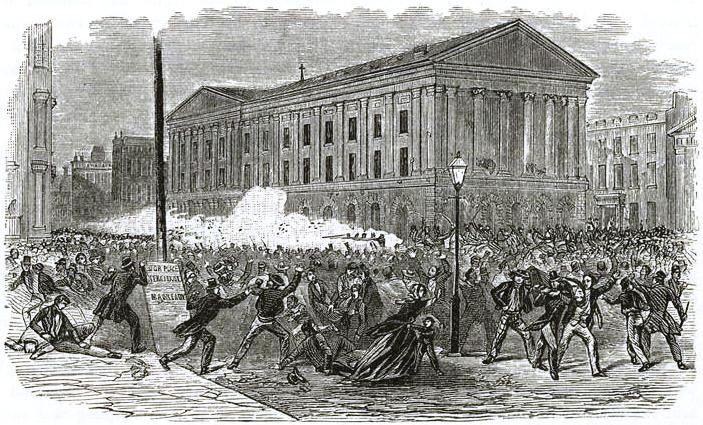
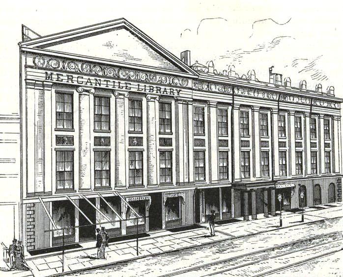
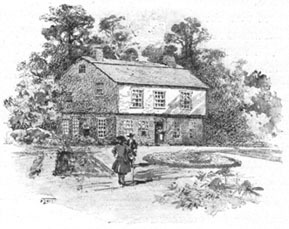
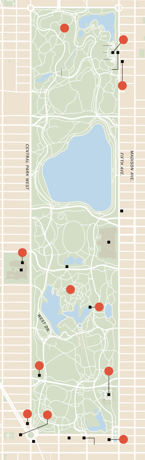
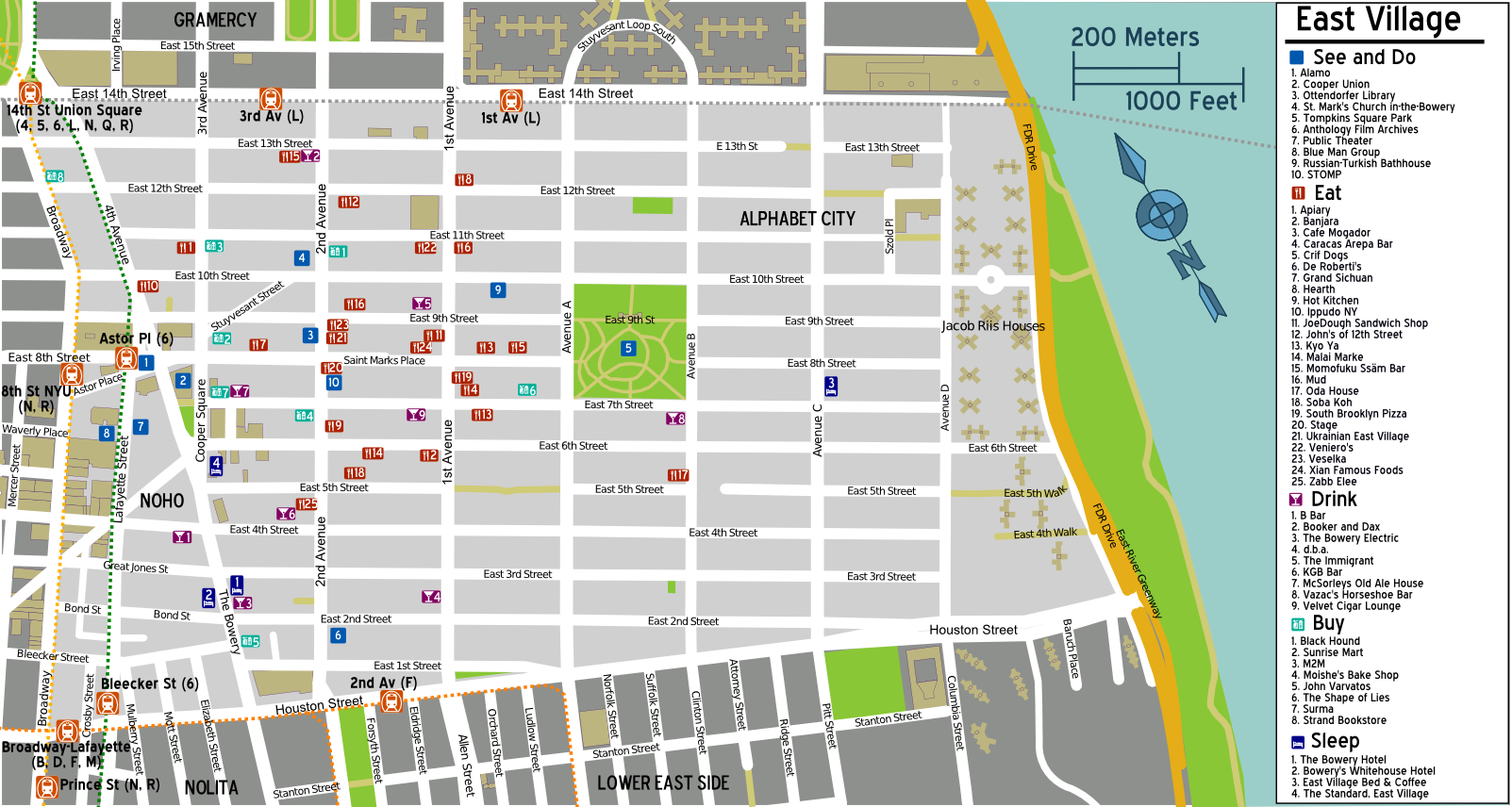