|
Reflections 2012
Series 8
June 8
Atlantic Isles III: Madeira
| | Madeira Airport You’d never expect to find a discussion of such an attractive place as Madeira to start with talking about the airport, but that’s a necessity here. We were so innocent the first time we flew into Madeira--although things are now better. | | | | In June-July 1987 we went to Portugal. I don’t know why the Azores didn’t interest us at the time, but Madeira did, and the easiest way to include Madeira was to fly to Lisbon and then backtrack immediately, before we got started visiting the mainland. | | | | [Incidentally, although I didn’t plan it that way, since 25 years have passed, this happens to be my Silver Anniversary Visit to Madeira. We had visited the Canaries two years earlier, on a no-longer-existing direct flight from the US, during our schools’ winter vacation in February 1985, so it’s more than a Silver Visit there.]
| | | | I will admit to not remembering many details of the visit. As I planned things to do this trip, I was surprised we’d done most of them earlier. I do remember two things. One was driving along a high mountain ridge on the western side of the island, and didn’t plan repeating that. The other thing was the landing and takeoff at Madeira Airport.
| | | | I’ll start simply. The airport is at the edge of a cliff. Picture throwing a paper plane across the room toward a bookcase. You’d expect it to fly down and land on the lower shelf. But what if it landed on an upper shelf? It’s white-knuckle time.
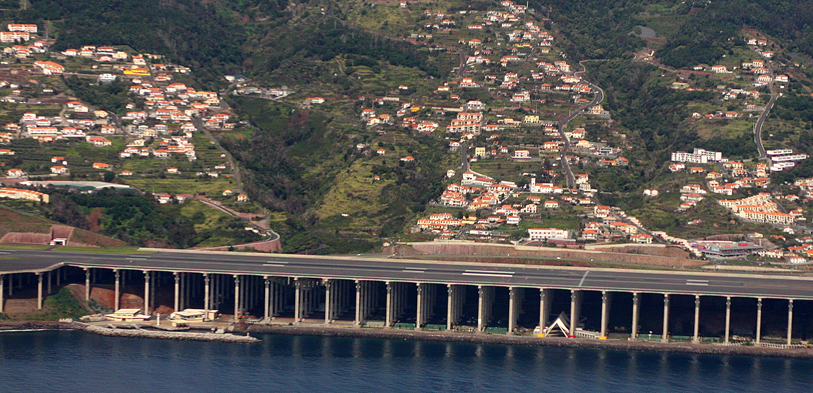
| | | | I remember approaching the island back then, looking wa-a-a-y down at the ocean, expecting it would still be a few minutes until we were close enough to the airport to land. Then, as I continued to look down out the window, a runway shot under the plane and we landed on it while we were apparently still way up there. And the pilot braked and reversed engines! It seemed worse when we left. The pilot first revved and got a reserve of power, then shot off. You were watching a runway below, it disappeared suddenly and the ocean was far below again. | | | | Innocent then, we didn’t realize that BOTH ends of the runway ended at cliffs, and that even the most experienced pilots were wary. I only learn this now, as well as the fact that the original runway was only 1,600 m (5,249 ft). But it was rebuilt in 2000, almost doubling the length of the runway. It’s still listed among the less safe airports of the world, but it’s a lot better. | | | | When I look at pictures of it now (which I didn’t have online access to then), I see the problem. Drop a large rock into a pond so that it protrudes. Where’s the coastline? Where do you put towns? Where do you build roads? Where do you find something flat enough to build an airport? Islands like Madeira consist of ravines that have eroded through rock, so that you have rock, ravine, rock, ravine. You put towns where you can--Funchal is on a steep slope. You build roads--and vias rápidas--so that they go from tunnel to viaduct to tunnel--and then maybe some flat land before the next tunnel. They found space for the airport on the east coast, between two ravines, on a headland they flattened, which resulted in the north-south runway pointing over two adjacent ravines.
| | | | They solved the problem, not by using an awful lot of landfill in a ravine, but by building the runway extension out to the north on a series of 180 columns, each about 70 m (230 ft) tall. For this solution, the Funchal Airport won the 2004 Outstanding Structure Award, the Oscar for engineering structures worldwide, given by the International Association for Bridge and Structural Engineering. I have three pictures that show the result. This is the best one showing the ensemble view (click to enlarge). We are inland looking out, with the terminal and original runway to the right, and the columned extension to the left. However, as you can see, the via rápida encircling the eastern part of the island, which I drove the next day, runs through the columns and around the sea side of the airport. This view shows the columns from below. Finally, this view is from over the water looking inland (westward), and shows only the extension. Another reason for showing this picture: look at the houses built up on the hillsides, and especially, look at the ravines dividing the land areas. | | | | You only have to look at the number of videos on YouTube about this airport to get an idea that it’s still something to talk about. This was taken from a cockpit, so it’s particularly dramatic as it shows the spectacular approach. As it turns out, it’s a SATA plane, like I arrived and departed on. The whole video runs 4:20, but if you want to jump to the touchdown, it’s at 2:35. By the way, the landing still involves brakes and reversing the engines, and the takeoff revving up. | | | | I got my car and drove the 15-20 minutes into Funchal on the via rápida. I immediately got used to turning on my lights, because of all the tunnels. This picture in Funchal, looking south toward the ocean, shows the highway coming out of a tunnel, crossing on a viaduct, and entering another one, while in the ravine below, four city streets look like spaghetti, with one going into a tunnel of its own. I nevertheless had checked my directions on Google Maps earlier, and swung around to the western side of Funchal, and down near the water. However, once local, I did drive around in two loops looking for the hotel, because of one-ways. But I made it. | | | | Madeira Like the Azores, Madeira (on this French map, Madère) is Portuguese, but unlike the Azores or Canaries, it’s only technically an archipelago. The only other island of significance is much smaller Porto Santo, 40 km (25 mi) NE. As a matter of fact, in 1419, an expedition sent by Prince Henry the Navigator (!!!) first landed on Porto Santo, then on Madeira. Since it was entirely covered in woodland, they called it Ilha da Madeira, literally Island of Wood, or, more freely, the Wooded Isle. The whole archipelago is a series of oceanic volcanic islands sitting above a hotspot on the African tectonic plate. (Neither this nor the Canaries are on the Mid-Atlantic Ridge, but on local hotspots.) | | | | I didn’t double the size of the island I’m visiting here, since, surprisingly, Madeira is 98% the size of the largest of the Azores, São Miguel, where I just was, so we’ll call them equal. On the above map, notice the places I’ll be mentioning. The airport is in Santa Cruz, Funchal is in the south, the Pico do Avieiro is north of that, and Santana is on the north coast. | | | | If that map didn’t show enough steepness, look at this 3D view of Madeira. Want to build a highway there? You’ll see that the east coast is best for an airport, Funchal (in white) climbs its slope, and why, when I drove from Funchal up to Pico do Avieiro and down to Santana, why I chose to take the via rápida back past the airport to Funchal. Yet Madeira today has a considerable population of 276,000.
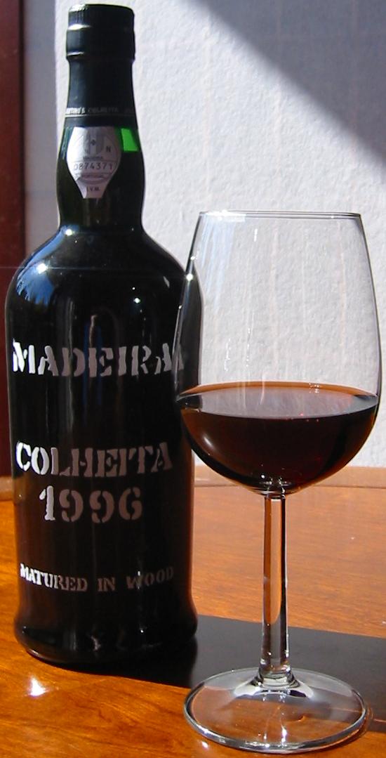
| | | | Madeira (Wine) It’s possible that when one hears the word “Madeira”, one might think of the wine called Madeira before thinking of the island itself. Madeira is a fortified wine, such as Portugal’s port or Spain’s sherry, although to my mind, much closer to port, which is my favorite fortified wine. Madeira can be dry or sweet, and I’d never fully enjoyed a glass of Madeira until I had some after dinner at my hotel this trip. The waiter suggested a semi-sweet one evening and a sweet the second. I really enjoyed them both, although I think I’d go with the semi-sweet. Of course, part of enjoying the wine was just “being there”. | | | | Grapevines were introduced in the 15C, and fortifying the wine goes back to the Age of Exploration, when commercial ships stopped at Madeira regularly on transatlantic voyages. To prevent the wine from spoiling, neutral grape spirits were added. It was also found that the flavor of the wine was improved to exposure to heat and the movement of the ships. (Here is Madeira being aged in casks at a winery.) In 1660, a commercial treaty with England encouraged the export of Madeira wine, particularly to England, where popularity reached its height in the 18C and 19C. Today, the wine is heated deliberately and exposed to some degree of oxidation. Most countries limit the use of the name Madeira (or in French, Madère) only to wines actually produced in Madeira, where the European Union gives protected status to the name.
| | | | Quinta da Penha da França You can see I found another Quinta, right to the west of Funchal, a ten-minute walk. And it had plenty of parking. But unlike the earlier Quinta, this area had built itself up into a busy hotel district, even though the Quinta was originally agricultural (mid-19C). The Quinta itself was a relatively modest, three-story house, and remained private. But it faced the old gated entrance, and across a narrow side street was a chapel that I’d read once belonged to the estate. But the hotel buildings themselves were older, comfortable outbuildings around the Quinta, with the modern entrance on another side, on a more substantial street. | | | | The essence of this Quinta was its garden. Everywhere there were trees, shrubs, flowers, bubbling fountains, pools with fish, and a swimming pool hidden amongst the shrubbery. I read in a summary that the trees included wisteria, jacaranda, yellow Burmese (giant) honeysuckle, and Canary (Island) palms. My room was on the ground floor, and all rooms had terraces or balconies. From my terrace you could walk out onto a mid-sized lawn with large red bushes across. To my right, a half-level higher, was the terrace of the restaurant. From the garden was a view out over the sea. | | | | But the hotel had begotten another hotel, down the hill, and closer to the sea. It was called Penha da França Mar, leaving out the word Quinta, for a good reason. One was invited to visit it, and use its facilities if one wanted. I couldn’t imagine why one would. To get there, you leave the magnificent garden through that old original gate opposite the chapel, cross a bridge over a main road, and on the other side, enter a tower with an elevator down to a sterile building, with not a tree in sight, and two swimming pools. Curiously, I found a picture of the Penha da França area that shows this (click to enlarge). | | | | Note the beautiful garden on the right. You can see the modest Quinta and the red-roofed outbuildings. Follow your way past the chapel over the gray bridge above the road and down the tower to the first of two, lower red-roofed, buildings. It has a large pool, and a smaller, kiddie pool. Don’t mistake the other large pool for anything, since that belongs to the next hotel! There is no beach, just rocks, and what they call a “swimming platform”. This is Madeira! | | | | Of course, I got hung up on the name. França is France, and Penha is Rock, but like Spanish Peña (they’re also pronounced the same), it’s a large rock, approaching a mountain. Rock of France? French Rock? Was that the slope the Quinta was on? A nearby rock? Nothing made sense, and the concierge couldn’t help. It wasn’t until a week or so later that I decided to look it up in English Wikipedia. No entry. But “Penha de França” in Portuguese Wikipedia had a small entry, that included this explanation: “A Penha de França é uma montanha no sul da provincia de Salamanca.” I’m sure you can get the gist. Salamanca, the famous Spanish university city, is in a province of the same name, and this place is a mountain in its south. So it had nothing to do with Funchal. So why the name? I went to Spanish Wikipedia, which grudgingly gave a bit more: “Conocida por su virgen negra.” In other words, this mountain was known for its black virgin. Then it struck me. That little chapel across the side road, which dates from 1622, has as its complete name the Ermida da Nossa Senhora da Penha de França. It was just like the Quinta das Mercês! A secular building had been given a religious name. Well, if it’s the Chapel of Our Lady of the Rock of France, then the Quinta da Penha da França is French Rock Manor, as long as you remain aware of the religious reference via Spain to France!
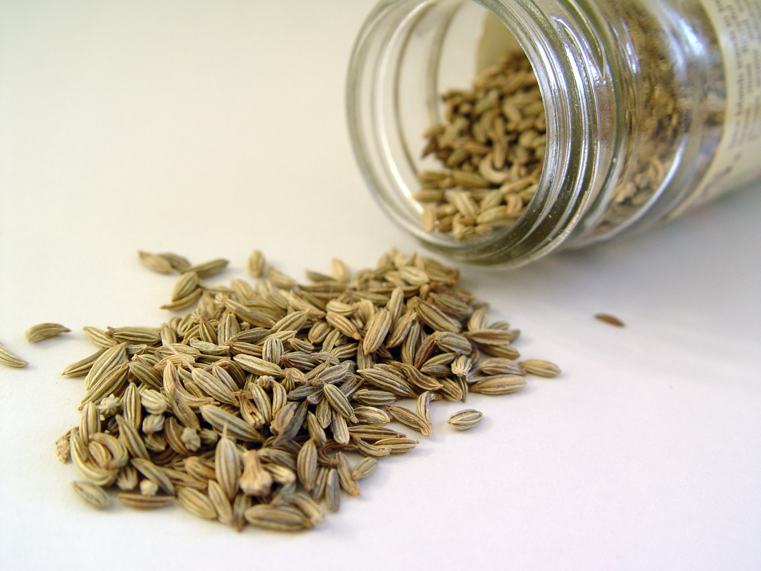
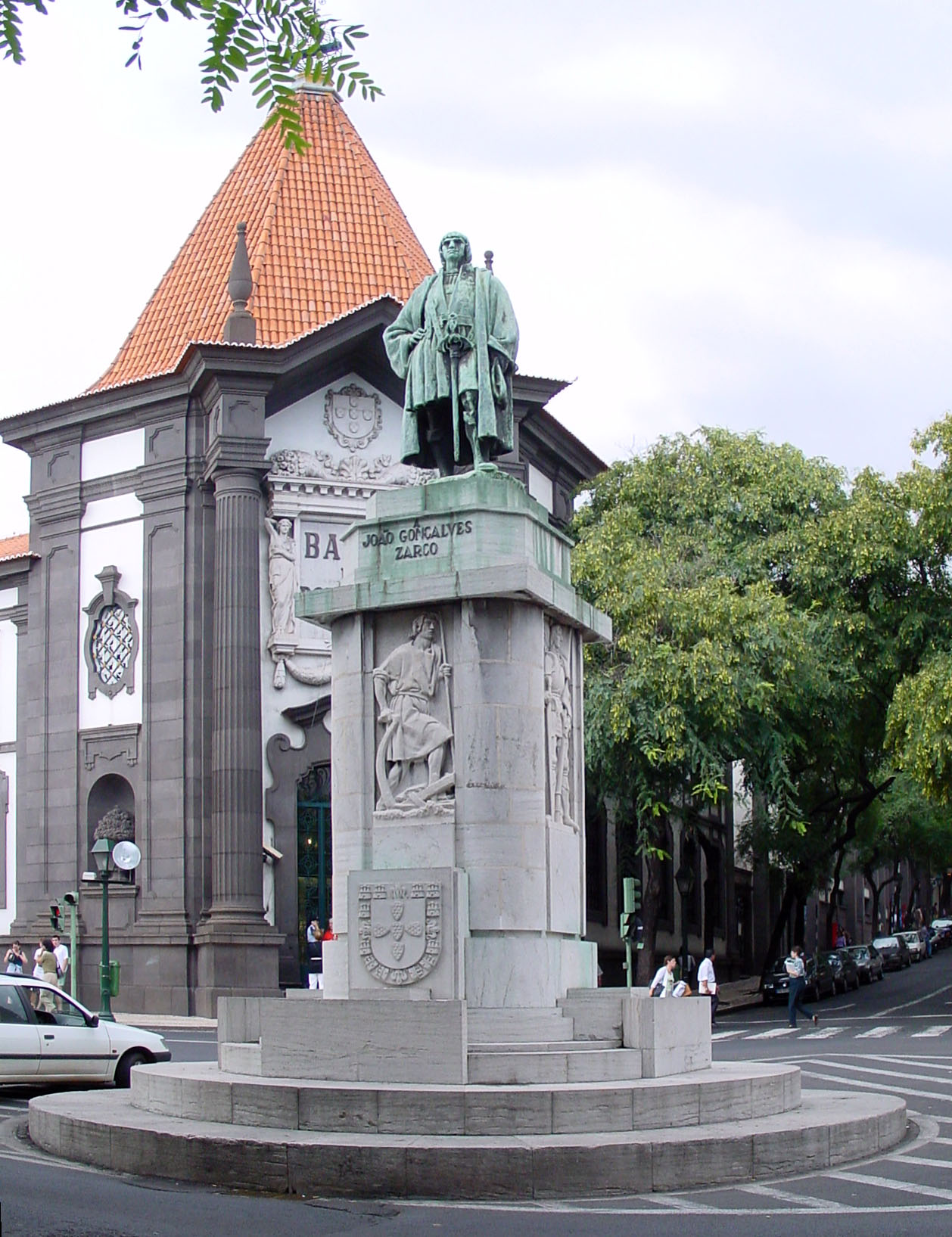
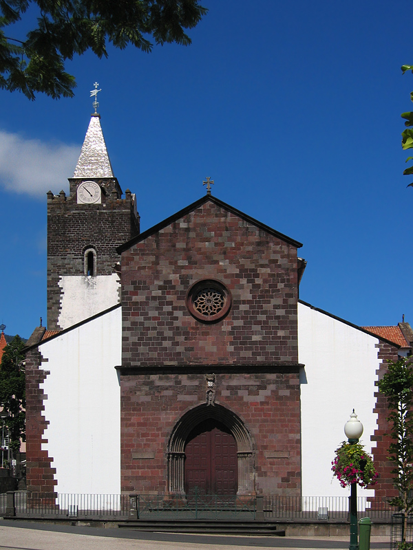
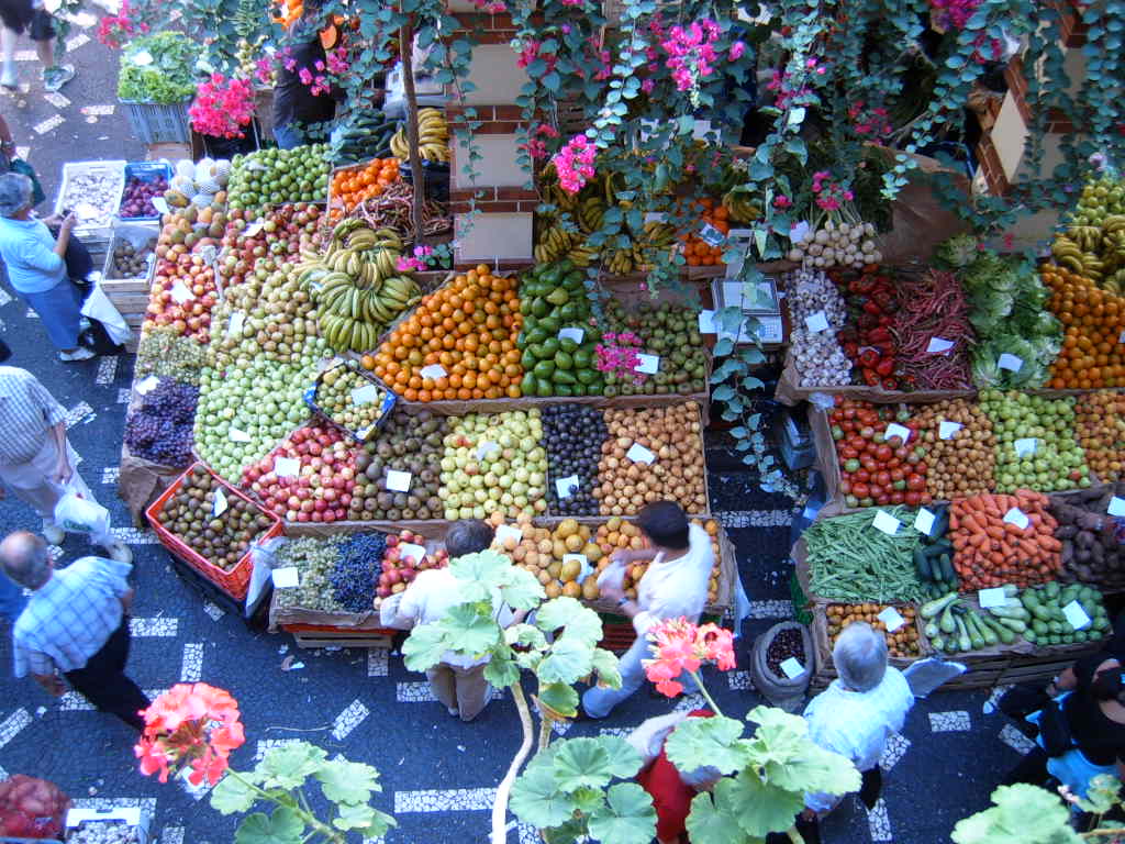
| | | | By the way, talking about the word “Quinta” being used for estate-bottled wine, I had for dinner one evening a Quinta da Cabriz wine from the Dão region on the Portuguese mainland. I say this just to point out again that the word “Quinta” is everywhere. | | | | Funchal Funchal was settled about 1424, and has grown to a population of 112,000, all living on the slopes of those hills. We referred to the name when we said that Spanish and Portuguese have the suffix -AL that groups together growths of the same trees and plants, so that Faial meant Faya Tree Grove and a juncal could be a “cluster of reeds” (2012/6). We also said that Portuguese “funcho” (FU [NG].shu) was the highly aromatic and flavorful herb fennel, which tastes similar to anise. This is a fennel plant in flower, and this is fennel seed. Note this quote: "Funchal, to which the captain gave this name because it was founded in a beautiful forested valley, full of fennel up to the sea." So how do you translate Funchal? | | | | I’ve seen sources that said it was a fennel garden, but I don’t buy that. A garden is purposely planted, and that isn’t the case here. What I’ve come up with that I like in this case, since English doesn’t have a grouping suffix like -AL, is “field”. A field can be wild or purposely planted, so for me Funchal is Field of Fennel, or Fennel Field. And then that gets me thinking. Doesn’t Fennelfield sound like an English estate? Couldn’t Jane Austen have had Mr Darcy visiting friends at Fennelfield? Or maybe Charles Dickens could have had David Copperfield arriving at Fennelfield to join his aunt Betsey Trotwood? The mind doth wander. | | | | After I settled in to my “garden Quinta”, I still had half an afternoon, so I took the short walk due east into Funchal. On the way was the seaside Parque de Santa Catarina, and I stopped to read, as usual, an interesting-looking monument. It explained in English (first) and Portuguese, that, at the beginning of WWII, when Gibraltar was threatened with attack, Gibraltarians had to be evacuated. Madeira accepted 2,000 in the summer of 1940 in hotels, boarding houses, and private homes, where they stayed to the end of the war. The monument commemorates their stay and their gratitude. It was obvious that it was Madeira’s isolation from the mainland as an “Atlantic isle” that made it a safe haven. | | | | The road soon became Avenida Arriaga, the main street, actually a wide boulevard with a park down the middle, that had numerous jacaranda trees all along its length, and, as I later read, they bloom in spring, the time of my visit. Their unusual shade of purple makes them very distinctive. As it turned out, we were in the midst of a Festa da Cultura, and there were numerous booths under the trees, in this case, all exhibiting books. | | | | Halfway down Arriaga was, as it was described, a “Monumento e estátua de João Gonçalves Zarco”, who established settlements in Madeira on the instructions of the Infante Dom Enrique. (One catches on easily to a little bit of Portuguese.) At the end of Arriaga was the 15C Sé (Cathedral), the first one built outside of mainland Portugal. | | | | [You may remember in Angra I also talked about its Sé, and may wonder why many languages call the building instead using a word similar to “cathedral”. It all comes down to chairs--or seats. The building in question is the seat of a bishop. The Latin word for “chair” is “cathedra”, so you see how that developed. The Latin word for “seat” is “sedes” (Italian “sede”), a word that shortened in English into “see” as in “episcopal see”, meaning literally the bishop’s seat, and then taking on more abstract connotations. It shortened further in Portuguese to Sé.] | | | | This is a pleasant square and street scene near the Sé. A couple of blocks north was the Praça do Municipio, the City Hall Square, with the usual palaces and churches, and colorful sidewalk. But wait! What’s that at the top of the fountain under the cross? Do I spy an armillary sphere (2012/7)? I certainly do. | | | | Back on Arriaga, I listened to a strolling brass band for a while. Then I felt I had to participate in the Festa da Cultura, so I went into a booth and looked to see what I could find. I flipped through a “Português-Espanhol” dictionary, just to see some differences between two languages that are so similar. Then I picked up a copy of “Um crime no Expresso do Oriente” by Agatha Christie, and found interesting the variation from “Murder on the Orient Express”. Finally, I picked up a book of Edgar Allan Poe’s short stories, to see if I could figure out any titles. Two fun ones were “O Poço e o Péndulo” and “O Coração Revelador”. Any ideas? | | | | In the first one, if you recognize the last word and you know a bit about Poe, you’ll realize it’s “The Pit and the Pendulum”, but the second one is trickier. It helps to know that the Spanish word for “heart” is “corazón”. Does that help? “The Revealing Heart” is known in the original as “The Tell-Tale Heart”. | | | | To finish discussing Funchal, I’ll jump ahead to two days later when I drove to the eastern side of town to take a gondola lift up to Monte. I walked a bit first through the Vila Velha (VEL.ya), the 15C Old Town, where many narrow streets were pedestrians only, and also stopped in the public market, which was more colorful than usual. Aside from the fish market area, smelly and gruesome as usual, there were very attractive and colorful displays of fruits and vegetables, and flowers. | | | | Beyond Funchal, it was a matter of attacking those hills. My second day was devoted to driving my usual “mountain circuit”, and the third day was for the gondola lift to Monte, above (well above) Funchal itself. Take a good look now at the hills above Funchal. At mid-level, you may be able to trace a highway going in and out of tunnels and over viaducts. But also admire the views that these hills afford from up above, of the typical orange roofs, the groups of jacarandas, the tower of the Sé, the harbor.
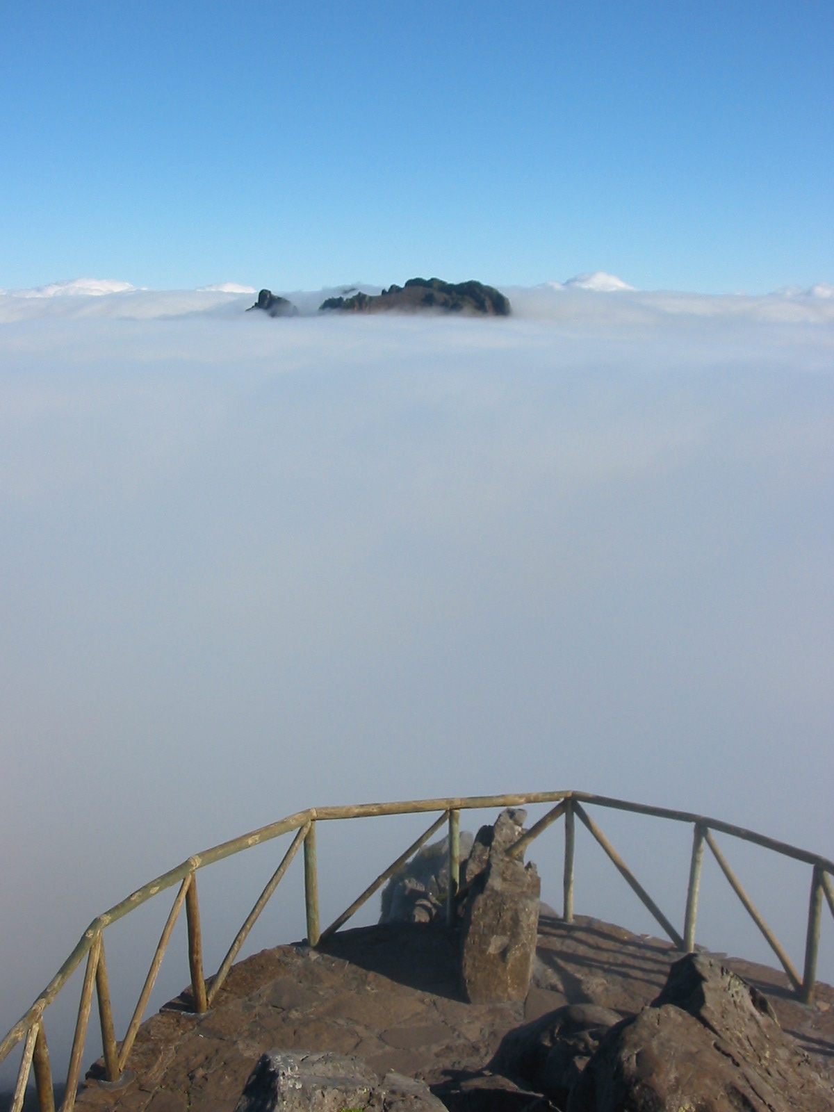
| | | | Pico do Arieiro Since I had to cut across town to get the road up the mountain, I was glad I could let my “mountain day” fall on a Sunday. Still, with less traffic, it was confusing, and I lost the zigzag through town, but picked up another one and was on my way. I wound back and forth uphill, as you usually do on mountains, but this was still in town, and there were houses all along the road. And bus stops. I don’t know how bus drivers manage. The road had a U-bend abutting Monte, where I’d go the following day, and I found myself getting a quick peek at a charming tree-shaded square I later found out was Largo da Fonte. But I continued up and up. | | | | There is a cluster of high peaks in the center of the island above Funchal, and I was headed for one of them that had a spectacular viewpoint of the others, the Pico do Arieiro. But Funchal was under an overcast, and as I went up, I got more and more into the fog. Still, I took the Arieiro turnoff at the pass, wondering if it would work out, and once again, as had happened in Pau years earlier (2005/16), I broke through the clouds and into bright sunlight, and reached the viewpoint. | | | | This is the western view from Arieiro on a perfect day. We are at 1,818 m (5,965 ft). Funchal would be to the left on the south coast, and Santana to the right on the north coast. That depression is Curral das Freiras (more in a moment), whose entry valley is from west of Funchal. Note the highest peak on the right. This is that peak on a cloudy day (believe me, Wikipedia has everything.) Now, have no fear, it wasn’t like that. I could not see down to either Funchal or Santana, but I could see all the high peaks, and into Curral das Freiras, which satisfied me. | | | | Curral das Freiras I backtracked to the pass, and went down to the north shore, winding back and forth through occasional pretty villages, valleys, and streams, to Santana, which was an interesting stop I’ll discuss in a moment, but to keep on topic about mountains and valleys, I’ll skip it for now. I was headed for the Curral das Freiras I’d just seen, and I wasn’t about to backtrack over the mountains, so I did a backwards C around the east coast, which very soon became the via rápida, under and around the airport, back to Funchal and beyond, and then north into a winding valley up, and up, and up again, past wonderfully scented eucalyptus trees, to Curral das Freiras. I purposely passed the turnoff to the viewpoint, which I’d stop at on the way back, since I wanted to go into the town itself. To do so, I entered a very long tunnel sloping downward, and drove a bit around the village at the bottom of high cliffs. How hard it must have been before the tunnel! You could see the road they used to use hugging a cliff! You’d have had to have been a mountain goat! I then returned up through the sloping tunnel and then finally turned up toward the viewpoint ahead, which was much higher (this is Madeira). This is not the distant view from Arieiro, but the closer view from the local viewpoint at Eira do Serrado at 1095 m (3591 ft) of Curral das Freiras. | | | | The town lies spectacularly, and very isolated, in the bottom of a cirque (SIRK) of extinct volcanoes. If you think that “cirque” is the French word for “circus”, you’re right. But “circus” also can refer to a circle, as in the Roman Circus Maximus, or in London’s Piccadilly Circus. A cirque in the geographic sense is an amphitheater-like valley-head that has been formed by erosion. It is concave, and is open on the downhill side, the other three sides being steep cliffs, as is apparent in the picture. This cirque is at the head of a valley that was particularly difficult to traverse, up until modern times with newer roads, plus that tunnel. Look again at that picture and note the thin black line on the lower right. That was the old road, before the tunnel, which goes through that mountainside. This is a prettier view showing less of the cirque and more of Curral das Freiras. | | | | But in the name of the town we have another example of, if not bad translation, inadequate explanation. Curral das Freiras is translated as Corral of the Nuns or Nuns’ Corral. It is accurate, but sounds stupid, since one doesn’t corral nuns. A vague story is given in writeups that nuns fled pirates to seek refuge there, so sometimes you see the translation Refuge of the Nuns, which sounds nice, but which doesn’t explain the corral. English Wikipedia doesn’t know enough about this Portuguese subject, so off to Portuguese Wikipedia again. | | | | It clarifies the nuns’ being there by saying that between 1492 and 1497 (just think of dates like that!!) ownership of the property passed to the convent of Santa Clara. Then, in 1566, when Funchal was sacked by French pirates, the nuns fled to this property they already owned. Good enough, but that doesn’t explain the corral part. So let’s read further together, and see if you can just get the gist: | | | | | | No princípio da colonização o Curral das Freiras possuía apenas a designação de Curral ou Curral da Serra, derivando esta do facto de ser este local um centro de pastagens. |
| | | | I had to look up “pastagens”, which are pastures, but the word does resemble “pastors”, in other words, shepherds. But do you follow any of the rest? | | | | This is what I get, and I’ll keep it stilted in order to follow the original more closely. | | | | | | In the beginning of colonization, the Curral das Freiras possessed only the designation of Curral or Mountain Curral (think “sierra”), deriving this from the fact that this locality was a center of pastures. |
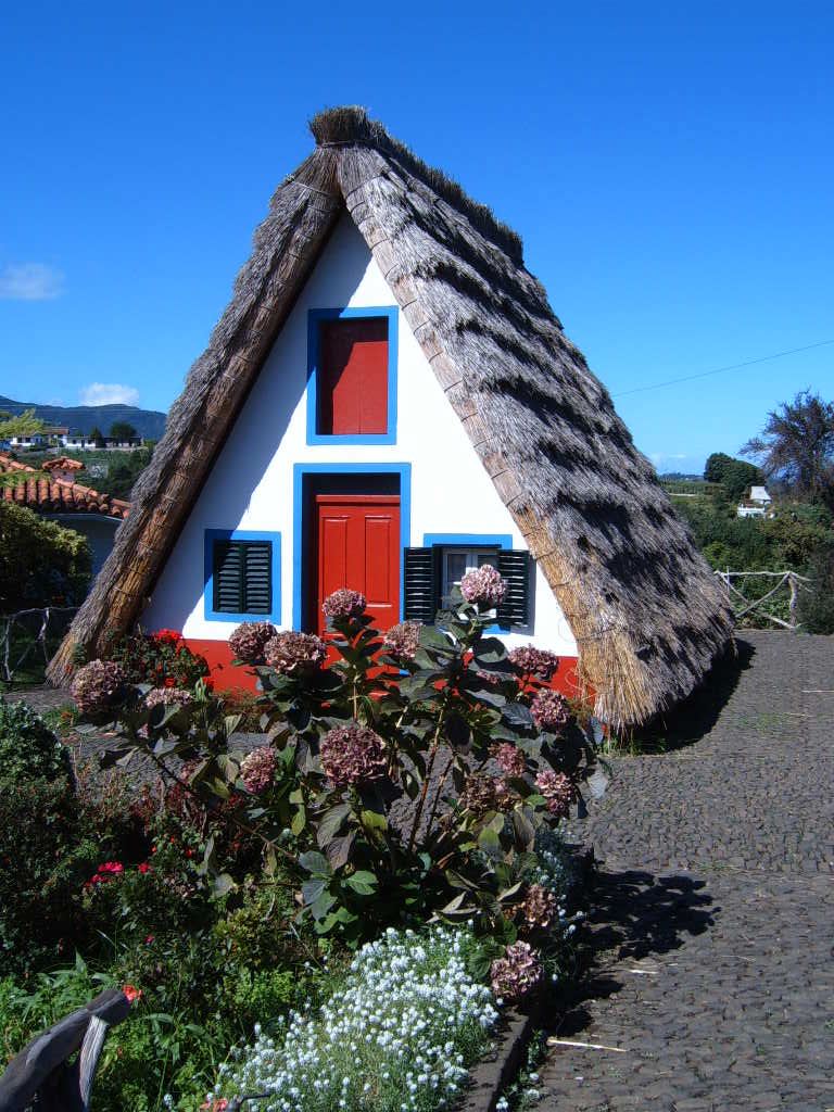
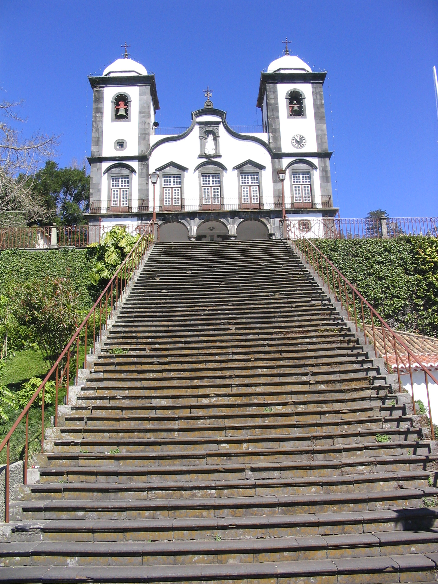
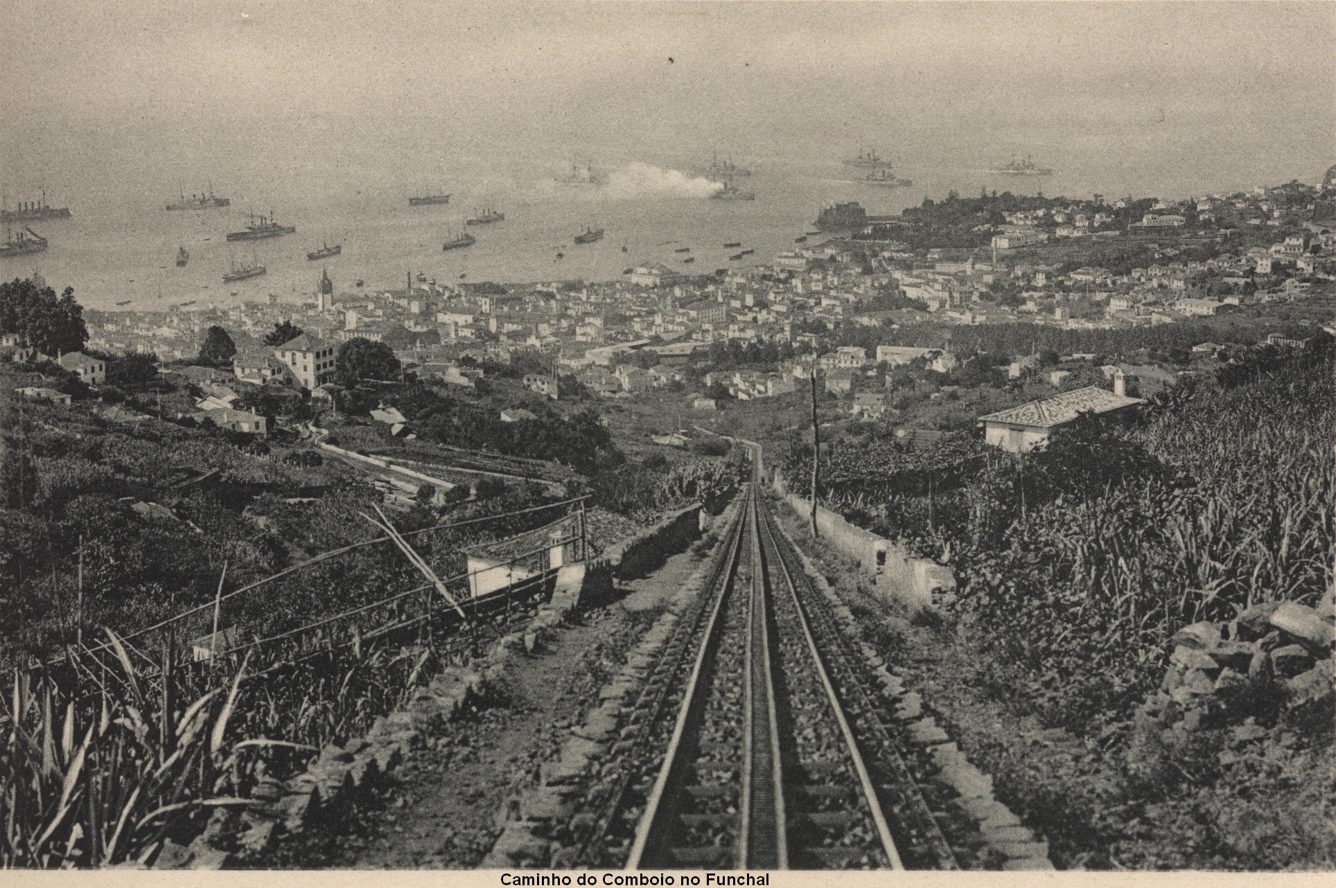
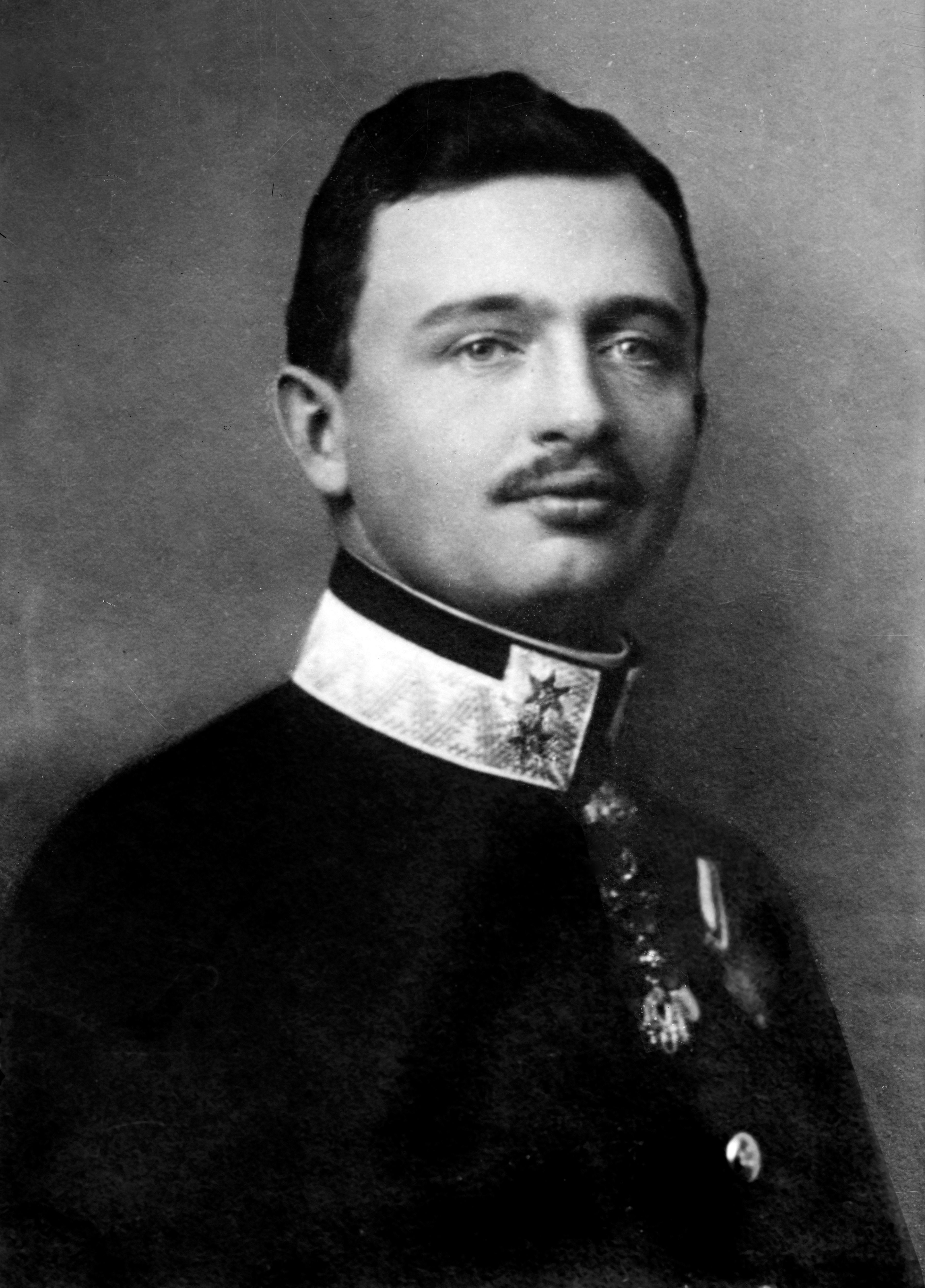
| | | | Pardon the stilted translation. In other words, early on, because it was so remote, animals were kept there, and it was simply called the Corral (or Mountain Corral). When the nuns moved there, it was called the Nuns’ Corral, as opposed to any other corral. The original translation just needed deeper explanation. | | | | Santana Now back to the middle of the afternoon, when I stopped in Santana (from Santa Ana) on the north shore. The village is nice enough, high up, with a view of the sea, and centers around this handsome, contemporary City Hall. But this is not a reason to stop. Santana has reconstructed, on either side of this City Hall, surrounded by very attractive petite gardens, the traditional houses of Santana. | | | | There are five houses, all used for cultural purposes, but to one side was a sixth house, with no sign on it, that had lace curtains and might have been regularly inhabited (perhaps by a caretaker?). Of course, most of the town had modern houses. I read that these had been rural houses, even farmhouses, that were restored and collected here. | | | | Each tiny garden had a sign. There was a Jardim das Hortênsias, which, you may remember, were hydrangeas. Over near the Casa das Flores, inside which a woman was selling flowers and bulbs, there was a Jardim da Camélia, Jardim das Rosas, and a Jardim das Azáleas. | | | | The houses are unusual most strikingly for their triangular shape, but of course, their straw roofs stand out as well. While they look like you should expect to see Hänsel and Gretel any minute, they are of reasonable size for people to stand and walk around. The white walls, red doors, and blue window trim are all typical, and have to be maintained. For instance, the straw roofs are replaced every four to five years. Originally, they all had an attic for agricultural storage. The ground floor was the living level, often divided into two parts. It’s believed these were primitive constructions, and were made of wood (madeira!) which was plentiful, as there was little hard rock for construction, anyway. | | | | One of the houses was labeled Doçaria Tradicional. After a moment, I recognized that “doce” is sweet, and this was a Traditional Sweet Shop. She was selling cakes and candies, and had free samples of a type of ginger snap. When I left Madeira, little packages of these were given out on the plane. | | | | One garden at first seemed shabby, if not weedy. It was labeled Jardim de Linho, and inside the house, labeled Artesanato (Artisan Shop), a wrinkled lady was spinning linen, which, as she pointed out, was linho (LIN.yu), which explained the non-flowering garden. The way she was doing it seemed incredible, such a blend of old and new(er). She had on her lap a pile of linen fibers. There was a medium-sized bobbin on the table in front of her, but it was run by a little motor attached to its side! As the bobbin turned, the fibers were pulled through her moistened fingers and became linen thread wrapping itself around the bobbin before my eyes. | | | | Monte Since Monte lies 600-800 m (2000-2600 ft) above Funchal, it has always been a country resort because of its cool climate. It was also formerly a health resort for European high society. Its most obvious feature is the church of Nossa Senhora do Monte, which, with its high staircase, is visible even from a distance. I always wondered why a village would be named “Mountain”, and only recently realized what the name is all about. I always thought the church was named after Monte--Our Lady of Monte--but I’d gotten it backwards. It’s another example of a secular place getting a religious name, since Monte is named after the church. The church’s name is Our Lady of the Mountain, and Nossa Senhora do Monte is shortened just to Monte for the town. (Monte is usually simply pronounced without that E as MOH [NG] T.) | | | | Monte is a delightful, cool place to be, and should not be missed. It’s today just a neighborhood of Funchal, way up on the mountainside. There are several N-S roads up to it, but its essence is really one rather short, pleasant E-W street connecting everything of interest, the Caminho das Barbosas (Barbosas Road). I find it easiest to tell about Monte in four sub-stories, to follow immediately below. | | | | You arrive in Monte on the gondola lift (see “Gondola Lift” below) toward the east end of Barbosas, turn around and look down the slope you just came up, to be impressed with its height. Right across the road is the Quinta do Monte (what shall we say, “Monte Manor”?), where Karl I lived starting in 1921, and died the next year (see “Karl I” below). The Quinta do Monte is now a hotel, which everybody getting off the gondola lift totally ignored, except me, since I knew the background story. I climbed up its lawn on a long staircase, just to see the house. | | | | Just a few steps west on Barbosas is the bottom of the staircase to the church, Nossa Senhora do Monte, where Karl I is buried. Most people did climb the staircase to see the church, and perhaps learn rudiments of Karl I’s story, I don’t know, but I suspect that those who weren’t familiar with the history just looked at the view down the stairs, at the attractive church, wondered a bit about that tomb in a little room off to the left of the nave, and left. Unless you prepare yourself with background, you will never get everything from travel that you might. | | | | Back at the bottom of the church steps was that little bit of idiocy, the Carros de Cesto / Basket Cars. Actually, the less said about them the better, but see “Carros de Cesto” below. Continuing westward on the last bit of Barbosas, you enter a bit of a park that wraps to the right around the heights of the church and go down to the Largo da Fonte, Fountain Square. (Apparently, a Largo is smaller and more intimate than a full Praça.) It’s the most charming place up in Monte. There is a natural spring at the bottom of the hill with the church at the top, which has been made into a faucet-style stone fountain. Apparently there are both natural-health and religious connotations to the fountain. Anyway, it gives the Largo its name. Large trees fill the Largo, which also has an outdoor café near the fountain. But at the western edge of the Largo is a derelict building of interest, a former railroad station (!!!) which included a bit of good news. (See “Monte Railroad” below.) Right at this building was the bend in the highway that I’d driven up the day before, where I’d gotten my first glimpse of the charm of the Largo da Fonte, so it all now fit together. | | | | That is the framework of Monte while walking down Barbosas. Now for the details of the four stories, going between the sublime (three stories) and the ridiculous (one). We’ll start by getting that one out of the way. | | | | Carros de Cesto I will admit to giving this topic a highly prejudiced slant, but if it really interests you beyond mere curiosity, when you go to Madeira, YOU do it. “Carros de Cesto” translates as Basket Cars, although in some descriptions, I’ve seen the word “toboggans”, which seems silly to me. Right at the foot of the church staircase, pointing down a road forking off Barbosas, there are several dozen men in white outfits and straw hats. Two men at a time bring up a sled-like chair made of wicker, hence the name, resting on sort of greased wooden skids. Riders, up to three, take their seats, the two men (pilots?) give the carro a push down the slope, and off it goes downhill. Each man holds a rope attached to his side of the front end, for guidance. Once it gets started downhill, they jump on the back, and off they all go. I understand the shoes the men wear have treads like tires, for traction, giving what they’re doing. | | | | If you only watch, looking downward from the bottom of the church steps, you see only the initial takeoff, but further down the winding hill, the view of a Carro de Cesto in action would look something like this. (In this picture, one guy seems to have forgotten his white outfit, and both have forgotten their straw hats, but you get the idea.) Going downhill, you apparently also contend with the occasional car, since the road is not dedicated to the Carros de Cesto. The ride doesn’t get you all the way to Funchal, but only about halfway. I watched trucks coming back with stacks of carros on them, but never did see how the men got back. Tourists--and I use the word negatively, are apparently then left strictly on their own. | | | | From what I’ve read, it all started as an easy way to get local produce down the hill to Funchal for sale. By as early as 1850, people started riding them, and, given that Monte was a major resort, it became a very early tourist attraction. | | | | In all honesty, before leaving home and reviewing this “activity”, I wondered if I should force myself, against my better judgment, to participate. I realized that it was totally a tourist attraction (a dreaded phrase in my vocabulary), without any redeeming value, even if they’ve been doing it for 162 years. Well, maybe I’d try it. I also found out the prices, €45 for three, €30 for two, and a stiff €25 for one. I didn’t like being hit with what was essentially another single supplement, but I was still considering it. Then I read online some reviews on Trip Advisor before I left. Most who did it said they were glad they did, but would never do it again. And then there were the three negatives: 1) many reported that the men were not only aggressive about being tipped at the end, but they pressured for big tips; 2) one’s picture was taken while riding, and aggressive pressure was brought to bear to buy it; 3) one was left halfway down to Funchal in the middle of nowhere. There were taxis waiting, like vultures looking for fresh meat, to bring you either back up to Monte, or on to Funchal, at about €20, or four times the normal fare. Some grumbled online that they were bothered enough about this treatment that they just walked the rest of the way down to Funchal in about 20 minutes. All in all, I rejected participating in what I considered a very historic tourist trap. Fortunately, it was the only one encountered in Madeira or elsewhere so far on this trip. | | | | But it is a curiosity to watch. Here’s a YouTube video of most of a ride on a Carro de Cesto. | | | | Gondola Lift We leave the ridiculous for several instances of the sublime, starting with gondola lifts. This is a type of transportation--I really do hesitate to call it a ride, even though it does give a very nice ride along with providing transportation--whereby you “hang from a clothesline”. | | | | Well, it’s really a cable you hang from, but that gives rise to calling this a cable car, a term that even the one in Funchal (mis)uses. Let’s be sure what we’re talking about. Note these three types of transportation, all on the ground, and all using tracks. A cable car runs on tracks and connects underground between the tracks to a moving cable. These used to be common, but now exist only in San Francisco. They can take minor slopes reasonably well. A funicular is usually steeply sloped, and is found on the side of a mountain. It runs on tracks, and the cable works like two fists holding a scarf around one’s neck. On fist going down pulls the other one up, then vice versa. A cog railway (or rack railway) also runs on tracks, but in order to go up steep slopes (not as steep as a funicular, though), there’s a flat central track, or rack, with gear teeth, which a gear under the engine grabs securely onto in order to pull the train up the slope. Again, these three are all on the ground, have tracks, and while two use cables, one uses a rack. | | | | On the other hand, what we’re talking about involves cabins hanging from a cable, and has nothing to do with the ground or tracks. The cabins are usually referred to as gondolas. I don’t know why, since they’re nothing like Venetian gondolas, but they are. The best name in English is therefore gondola lift. I specify English, because there are fine names in other languages. Portuguese and Spanish (and others) use teleférico (the French version is téléferique). German uses Seilbahn. Bahn is that useful word found in Autobahn, implying a road, and Seil is a heavy rope or cable. I have heard in English the term “ropeway”, which seems to imitate the German, but it isn’t heard to often, and the word “rope” doesn’t imply as much strength as it should. So we’ll go for Gondola Lift. | | | | What is commonly referred to as the Teleférico do Funchal is run by Teleféricos da Madeira. It leaves Funchal from a harborside park on the east side of town, so I drove over from the Quinta, knowing there was a parking garage available. There is no pressure to try to avoid a parking ticket if your time runs out, since you just pay when you leave, so I was quite satisfied. | | | | The distance to Monte on the gondola lift is 3.178 km (exactly 2.0 mi), and you rise up slowly 560 m (1837 ft) over Funchal. The average speed is 4 meters (yards) per second, and the gentle ride takes 15 minutes in 8-seat gondolas. However, I had a gondola to myself both ways. This YouTube video gives more of an idea. | | | | The Teleférico do Funchal opened in 2000, 107 years after the former cog railway opened in 1893, wherein lies the next tale. | | | | Monte Railroad We build up, we tear down, the latter often foolishly. In 1893, Funchal--and Madeira--opened its one and only railroad. It was a steam-powered, one-track cog railway (see above) that went up the mountain from the center of Funchal right to what is now that derelict station in Monte on the Largo da Fonte. That made this little square the showplace, the main entrance to Monte, by both road and rail. By 1912, the railroad was extended further, to the next town up the mountain of Terreiro da Luta, at an altitude of 867 m (2844 ft). It lasted exactly a half-century, as it was torn up in 1943. I don’t know why, but perhaps the war effort needed steel. I can’t find any answers. The entire distance to Terreiro da Luta was a total 3.911 km (2.43 mi). | | | | If the railroad were still there, it would not only be a means of transportation, perhaps updated from steam, but would certainly attract visitors, going perhaps one-way by gondola lift, the other way by cog railway. But the positive news I found out was first at the derelict station, where a sign said that the station was going to be restored and converted into a tea house and then a replica railroad would be built starting at the Monte station and going up to Terreiro da Luta, where the former station has apparently been a successful restaurant for some time. Present economics have, of course delayed implementation, but it was interesting that among the sponsors of the new railroad was, of all things, Teleféricos da Madeira, who apparently knows how to try to attract visitors. Online I found that, also due to economics, rebuilding the main part of the railroad down to Funchal is not foreseen, but the fact that it was discussed means that people have at least been thinking about it. | | | | Immediately south of the old station you can see that the present road is supported by a massive stone viaduct, which used to serve the railroad. As a matter of fact, there are presently two streets next to each other. The Caminho do Monte (Monte Road) was always the road for vehicles, but the street that goes over the viaduct is called the Caminho de Ferro do Monte. The first three words, as in many languages, means road-of-iron, so the street is located on the Monte Railroad roadbed. The alternate name for this street is Rua do Comboio, or Railroad Street. | | | | I’ve picked out some historic pictures. One is only available on English Wikipedia, but Portuguese Wikipedia has a larger selection. This shows a steam train leaving Funchal. This downward view shows the Caminho de Ferro do Monte, the railbed which is now the street by that name. Note the toothed rack between the tracks. This is where the train arrives at Monte, at the station on Largo da Fonte as it originally looked. Of course, you can’t fail to see the period Carro de Cesto to the right. Finally, this is the station and restaurant up in Terreiro da Luta. | | | | Karl I We’ve recently made two Madeira references to WWII, both to the railroad being dismantled, and to the Gibraltarians taking refuge in Madeira. We now go further back, with a reference to WWI. | | | | Beyond the chaos of the fighting, how the world changed. The sociological change is usually illustrated by the image of the prewar Edwardian woman, in picture hat, sleeves to the wrist, and skirt to the ankle--which would never be exposed--as compared to the flapper of the postwar 1920’s, who also was able to vote. But let’s also look at the changes in governments, and the end of long-standing royal houses. The French had become a republic well over a century before, but let’s consider Russia, Germany, and Austria-Hungary. | | | | Nikolai II, Tsar of Russia, abdicated in 1917 (15 March) after reigning 22 years, 4 months (plus 14 days). | | | | Wilhelm II, Kaiser of Germany, abdicated in 1918 (9 November), after reigning 30 years, 5 months (minus 6 days). | | | | To compare those two changes in royal houses to the change in Austria-Hungary, we first have to compare two long-reigning, and well-loved rulers, Queen Victoria of the UK and Kaiser Franz Josef I of Austria-Hungary. | | | | Victoria reigned as Queen of the UK between 1837 and 1901, for 63 years, 7 months (plus 2 days). Her dates are a little earlier than Franz Josef’s, and she died 13 years before WWI started. | | | | Franz Josef reigned as Kaiser of Austria-Hungary between 1848 and 1916, for 68 years (minus 11 days). He reigned longer than Victoria, but his dates are a little later. He was just as admired by his people. There’s a Victoria Station in London, and there’s a Franz-Josef-Bahnhof in Vienna. There were great tragedies in his life, which brought him closer to his people. His wife Kaiserin Elisabeth was extremely well admired up to her assassination in Geneva. I remember seeing fresh flowers on her tomb in Vienna, long after she died. His son Rudolf was a suicide in the Mayerling affair. And of course, it was the assassination in Sarajevo of Franz Josef’s successor Archduke Franz Ferdinand which precipitated WWI in the first place. | | | | And with all this, Franz Josef died right in the middle of WWI (1914-1918), in 1916 (21 November). With the turmoil of the war going on, one can only imagine how they arranged a funeral for a very well-admired Kaiser. If you can’t quite picture that, then picture what if Victoria had died in 1916. Furthermore, the other royal houses were still in place, since Nikolai didn’t abdicate until 1917 and Wilhelm until 1918. | | | | With Franz Ferdinand assassinated (the irony!), succession to the Austro-Hungarian throne fell to Franz Ferdinand’s nephew, Karl, who became Karl I--for a very short time. I remember teaching my German classes about all this, and casually dismissed Karl as a short-term, place-holding figure preceding the development of a series of republics. But the more I think of it, the more tragedy I see. Edward took over from the colossal figure of Victoria, but she was his mother. Karl took over from the colossal figure of Franz Josef, but wasn’t that closely related, and the “rightful” successor had been assassinated. What confusion. What a situation. What a mess. | | | | Karl I reigned as Kaiser of Austria-Hungary from 1916 to the end of the war in 1918, 5 days short of 2 years. He was asked to abdicate, but never did, since he wouldn’t do so with a figurative “gun held to his head”. What he did was to “renounce participation” in state affairs. Austria-Hungary was broken up into independent republics on 12 November 1918, but Karl always felt he could liberalize the monarchy (perhaps on the British style?) and hoped the monarchy would be restored--there were attempts--perhaps just in Austria, or in Hungary. | | | | He was considered a danger to the new republics, and he and his family were sent into exile, first near Vienna, then to Switzerland. But that was still too close for safety. There was talk of sending him and his family to some small, very remote island in the South Atlantic, similarly to how Napoleon had been sent to Saint Helena. The Council of Allied Powers indeed sent him to an island, somewhat, but not so extremely, remote--Madeira. It strikes me that Madeira was considered remote enough to keep Karl away from the republics, but also remote enough, two decades later, to keep the Gibraltarians safe. | | | | They arrived in Madeira on 19 November 1921. At first, they lived in Funchal, at a place called the Villa Vittoria, next to Reid’s Hotel, not far further west from where I was staying. But they then moved up to Monte, to the Quinta do Monte. But Karl would never leave Madeira. On 9 March 1922, he caught a cold walking into town. He developed bronchitis, which turned into severe pneumonia. He suffered two heart attacks, and died of respiratory failure on 1 April 1922, in the presence of his wife and family. She was pregnant with their eighth child. The last reigning Habsburg Kaiser was 34 years old when he died. | | | | I’d always pictured they lived for “a couple of years” in Madeira, 1921-1922, but I just counted the days from November to April. They were in exile in Madeira for only 133 days, or 4.4 months. | | | | For this reason I walked up the hill to the Quinta do Monte, now a hotel. When I then went up the steps to the church of Nossa Senhora do Monte, I found his statue on the terrace to the left. Inside, the smallish church, in a room on the left, was a large metal casket. There were fresh roses in vases, and banners around the room, many in German, at least one I saw in Czech that I could tell referred to “our king”. There have been several attempts to move his remains to the Habsburg Crypt in Vienna (where I’d seen the roses for Kaiserin Elisabeth), but they have not been successful, so Karl I, the last reigning Habsburg, remains in death a resident of Madeira. | | | |
| |
|
|
|

