|
Reflections 2012
Series 9
June 18
Atlantic Isles IV: Canaries: Gran Canaria
| | It was a red-eye transatlantic flight those years ago in 1985, from New York via Boston, then directly to the Canaries, first Tenerife, then Gran Canaria, our destination. We were trying to sleep in the darkened cabin, but it’s never good sleep, is it?. What time was it? Are we almost there? I was at the window on the right, so I lifted the shade to see if it was still total blackness out there. It was not. | | | | The dark, we were surprised to see, was now split horizontally by a very fine, but thickening, bright orange-yellow line. But that line was in turn unexpectedly broken vertically by a massive, looming black silhouette that we didn’t expect. It was our introduction to Teide. | | | | Canary Islands While there are nine Azores islands, there are seven Canary Islands. Among the largest of the Canaries are Tenerife and Gran Canaria. In population, they are the two largest, with Tenerife first at 907,000, and Gran Canaria second, with a close 846,000. Arriving here, I’ve left Portugal and entered Spain. | | | | The Canaries are located, perhaps surprisingly, just off the northwest coast of Africa, just 100 km (62 mi) west of the border between Morocco and the Western Sahara. Europe and Africa are close here, but not as close as at the Strait of Gibraltar up the African coast, which is only 14.3 km (8.9 mi) wide. The Canaries, like Madeira, are on volcanic hotspots within the African tectonic plate, not on the mid-Atlantic Ridge like the Azores--and Iceland. The Canaries are in a subtropical zone, but have a mild climate because of trade winds and cool ocean currents. This point is essential to their history. During the times of exploration and Spanish expansion, it wasn’t by chance that Columbus came by here. It was because of the favorable trade winds, which also made the Canaries the main stopover for Spanish galleons.
| | | | The winds and weather have a curious affect on the islands. In both Tenerife and Gran Canaria, the south is arid, and that is where the large beach resorts have been built, while the steeper, moister green north coasts are rife with banana plantations. | | | | The first Spanish expedition arrived in the Canaries in 1402. Four islands were subdued from the local Guanches early on, finally Gran Canaria was conquered in 1483, La Palma in 1492, and Tenerife in 1496. It’s worth considering that, when Columbus arrived on his first visit, to Gran Canaria, in 1492, La Palma was just being added to the Spanish collection of islands, and Tenerife still had four years to go. | | | | This map shows the seven Canaries, with the two major islands in the center. Las Palmas and Santa Cruz share the status of capital, while each heads its own province, as indicated on the map. Las Palmas is the capital of Las Palmas province, consisting of Gran Canaria and the two islands to the east, and Santa Cruz is the capital of Santa Cruz province, consisting of Tenerife and the three islands to the west. Las Palmas, as I’m sure we know, is “The Palms”, but is often called Las Palmas de Gran Canaria, since the name is common: Palma (singular, one word, otherwise Palma de Mallorca ), is the capital of Mallorca in the Spanish Balearics in the Mediterranean, and even one of the Canary Islands is named La Palma. Santa Cruz (Holy Cross) is similarly usually referred to as Santa Cruz de Tenerife. While we have the map available, I’ll say at the outset that I was lucky enough to have such clear weather available the whole time I was in these islands that I could regularly see back and forth between Gran Canaria and Tenerife, and on Tenerife, I could even see La Palma in the distance and La Gomera nearby.
| | | | Michelin Spain gives three stars each to Tenerife and Lanzarote, two to Gran Canaria. Two other islands get one each, two get none. I say they are mistaken about Gran Canaria. It deserves three, because of all there is to do and see there. Lanzarote is the easternmost of the islands, and shows considerable volcanic activity, as I understand it. When we came the first time, I vowed I’d include Lanzarote the next time. But now, I reviewed the difficulty of getting there and the lack of interesting hotels. What was described as attractive flowered parkland and volcanic areas sounded interesting enough, but you had to take a shuttle bus to the volcanic areas, and it really sounded like what I’d seen before, elsewhere, such as in Hawaii. So I decided against Lanzarote. What I did enjoy finding out about it was that it was apparently named after a Genoese navigator, Lancelotto Malocello, who visited it in the 14C, so that Lanzarote means “Lancelot”. I like that for the name of an island. | | | | “Canary” Talking about names, we have to address the elephant in the room, the word “Canary”, one of the most curious and misunderstood place names. The islands are named after a bird, right? Wrong. That common belief is backwards. Well, what are they named after, then? Dogs? Seals? Well, yes. | | | | To explain that, we have to first explain that all these Atlantic islands had been discovered a second time. It’s hard to believe that they’d been forgotten about in between. We’ve talked about Gibraltar and the Pillars of Hercules being a barrier, with warnings not to go beyond, and it usually was. But people being people, that doesn’t mean that there weren’t fisherman and other sailors who didn’t venture somewhat out into the Atlantic. We can’t name these sailors, just as we can’t name the merchants who traveled the Silk Routes to Asia long before Marco Polo, his father, and his uncle, but “everybody knew” that Asia was there, because word sifted back, and the same was with these islands, the Azores, Madeira, and the Canaries, which had been called the Fortunate Isles. The basis for that name is that the ancient Greeks believed that the gods sent virtuous souls there as a reward. The only thing about these islands is that, incredible as it may seem, people forgot they were there. The ancient Greeks alluded to the Canaries, but then Mediterranean civilization just forgot about them until they were rediscovered in the 13C-14C. That really was a shocker to me. How can you lose islands? I suppose if they’re not important enough, a culture just loses track of them. Yet the naming of the Canary Islands goes back to this first discovery. | | | | It all starts with dogs. The earliest reports were that there were huge dogs that lived on the Canaries. Pliny the Elder writes that King Juba II of Mauretania (roughly, today’s Morocco, right across the channel) sent out expeditions to explore the African coast and found these offshore islands. Juba reported that one of these Fortunate Isles was called Canaria after all the huge dogs found there, two of which were brought back to him. These dogs have apparently since become extinct. What’s the connection between “Canaria” and dogs? The Latin word for “dog” is canis, from which we get the word “canine”, meaning “pertaining to dogs”. So if we consider the Canary Islands instead in the form “Canine Islands”, the allusion appears much sharper. | | | | [Here’s a more complete summary, for those interested: the Latin name for “Canine Island”, or “Dog Island” was Insula Canaria, where, added to can(is), was the Latin suffix appearing, according to gender, as -arius, -aria, -arium, meaning “pertaining to”. “-aria” developed in French to “-aire”, passed into Middle English as “-arie”, and is spelled in Modern English as “-ary”. Thus, “temporary” is tempor+ary, and means “pertaining to time”, with the modern implication of a short period of time. Similarly, “Canaria” developed into “Canary”.] | | | | “Insula Canaria” originally applied only to Grand Canary, and only later, by 300 CE (=AD), did the name spread to all the islands in the group. I can find no reason to refer to this one island as “Grand”, since it’s not the largest island, other than the historical reason that the name spread out starting from here. | | | | But wait. Histories can be inaccurate. There is another speculation that what was found was not exactly dogs, but seals. (!!!) Don’t let that surprise you. Sea creatures are often named after land creatures. My best example in English is lion versus sea lion. They found a large sea creature and had no name for it, so they transferred the name of a large land creature to it, and it became a “sea” lion, even though it has absolutely nothing to do with a lion. | | | | The Latin term for “seal” was canis marinus. It’s obvious that that is “marine dog”, or “sea dog”. It’s also speculated that what was found in the Canaries was a species of monk seal, which are today critically endangered and no longer present in the islands. The reports and stories were passed on describing a canis marinus / “sea dog” and over time, the story got garbled and shortened into canis / “dog” as it traveled back into the Mediterranean. But personally, enticing as the seal story may be, I go for the dog story. Apparently, so do the locals, since the coat-of-arms of the Canary Islands includes what seem to be depictions of seven islands--and two dogs. | | | | Ah, but now for that little bird. It’s actually just a finch, which can be found in many places. But this is a variety that’s (mostly) yellow is found in the Azores, Madeira, and the Canary Islands, just like the faya tree is. Luck and chance come in here. It might have been named the Azores bird, but it wasn’t. It might have been named the Madeira bird, but it wasn’t. It turned out to be named the Canary bird--and we usually leave out the word “bird”. So there we are, a bird named after the islands. (It tempts one to play around with the name and make it “canine bird”, or even “dog bird”, but I won’t go there. Whoops, I already did.) | | | | There’s another surprise about the birds. Wild birds
are mostly yellow-green, with brownish streaking on the back. In captivity, a number of color varieties have been bred, and that includes the pure-yellow variety we’re familiar with for domesticated birds. Still, in 1991, the Government of the Canaries declared the canary one of the symbols of the Canary Islands, so the story comes full circle.
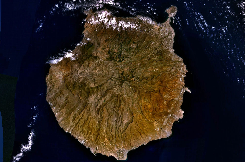
| | | | For the sake of completeness, we should mention that Tenerife is Guanche for “snow-covered mountain”, a reference to Teide. The Guanches, again, were the primitive people who had inhabited the Canaries earlier. The name is pronounced te.ne.RI.fe, four syllables, although English speakers often try to leave out the last syllable and unfortunately rhyme it with “reef”. The name does have another variation, though. In German and some other languages it’s Teneriffa. | | | | Gran Canaria Our first time in the Canaries, we had a week. We chose to stay on Gran Canaria, right in the heart of Las Palmas. Before we rented a car there, we took a day trip to Tenerife by ferry. It was, according to the travel diary, an 80-minute Jetfoil crossing to Santa Cruz, where we rented a car and toured the island. Little “down below” was particularly unique, and “up top” we went to Teide, but it was apparently in the clouds. The rest of the week was on Gran Canaria, where we also went “up top” and enjoyed the mountains, but “down below”, particularly memorable was the old town of Las Palmas, La Vegueta, and there, two images remain with me: the beautiful wooden patio of the Casa de Colón, and the brass dog statues in Plaza Santa Ana. I have very fond memories of that trip, but this time was even better. Better, yet very different in some ways, so I’m glad I planned it differently, to say “up top” on both islands, and in Paradors, at that. | | | | It is once again essential that the reader understand the geography of both islands in order to follow the commentary. Gran Canaria comes close to forming a perfect circle. It’s almost exactly twice the size of Madeira (or São Miguel), where I’ve just come from. Most distinctive is the “handle” on the northeast coast, at one o’clock. This is La Isleta, the northernmost part of the city of Las Palmas, which extends narrowly down the coast to that first indentation, where La Vegueta, the Old Town, is, at about two o’clock. The airport is visible at three o’clock, and Maspalomas, the center of the tourist resorts, is at six o’clock. That’s all of “down below” that I find of importance. You’ll see that the entire center of the island is mountainous, or what I like to call “up top”. | | | | The highest point in the mountainous area is Pico de las Nieves / Peak of Snows (also called Pozo de las Nieves / Well of Snows) at 1949 m (6393 ft). However, while this mountain affords outstanding views downward, it itself is hard to distinguish, and tends to blend into the landscape, which is very irregular, even choppy, with less-high mountains, valleys, craters, cirques--a rather confusing array. I will admit, I never fully understood the layout “up top” on the first visit, but this time it’s very clear to me. Knowing just what lies where adds considerably to the experience. | | | | I got to picture it correctly when I saw this excellent model of Gran Canaria (click to enlarge) later on in the Casa de Colón. Do note that this model is turned a quarter-turn, and the view is west, so that the La Isleta peninsula and the upper part of Las Palmas at one o’clock is now on the lower right, the airport at three o’clock is front and center, and the Maspalomas resort area at six o’clock is on the left. The first striking thing is to note that the northern half of the island, on the right, is green and lush, while the southern half is arid, hence the beach resorts. The mountains on all these islands serves as a cloud barrier, dividing the islands into two climate zones. | | | | You will understand the island if you picture it as I do, which is as an “upslope” and two immense valleys. On the model, imagine a road from Las Palmas on the right up to the top of the mountain. There are other approaches around the island to get “up top”, but this is the one that’s most practical, and the one I used. As you can see, I had to go north to las Palmas from the airport to reach this access, which goes via the towns of Santa Brígida and San Mateo. On my two round trips, I referred to them in my mind as “Bridget” and “Matt”. I’ll call this the Northeast Upslope. | | | | Now for the two valleys. From the high point at Pico de las Nieves on the model, there is a huge valley, a cirque, going south to Maspalomas. San Bartolomé (“Bart”) clings to the wall of this cirque. Let’s call it the south view. Finally, you may just be able to tell that, from the high point, there is a wealth of hills and valleys going west. It includes the town of Tejeda, among others, and this, the Caldera de Tejeda, is the biggest natural gem of the island. I’ll call it the west view. | | | | Arrival Some people might feel that, once they’ve seen a place, they’ve been there, and that’s it. It certainly can be. But another visit (or more) will given one distance to see change. The most blatant example of that is our multiple visits to Berlin over the years. To my surprise, it was truer on Gran Canaria / Grand Canary than I’d expected. | | | | I remember the mountain roads as being decent, but a little dusty. I remember having no problem with a hotel in Las Palmas, neither with parking nor driving around. When we drove around down below, there were regular, relaxed roads from town to town.
| | | | But now? I get my car rental and there’s the autovía / freeway right in front of the airport. Pow! Zocko! It’s autovía GC-1 (all roads inn Gran Canaria are GC and TN in Tenerife), which goes down to Maspalomas and up to Las Palmas. I am SO glad I checked Google maps in Madeira the night before I left for the route I needed. But I didn’t want to go to Las Palmas, the end of the GC-1, so Pow! switch to autovía GC-3 for several exits and then to GC-4 for a while. It wasn’t that hard, but unnerving. It was the Los Angeles freeways at rush hour. This was Gran Canaria? Not like I remembered it. | | | | The entire landscape down below was brown, but as the second and third freeways turned to lead me to the upslope, it started to become green. Then, suddenly, the autovía arrives at a redonda (roundabout/traffic circle) and I’m on a regular road entering Santa Brígida. Hello Bridgit! | | | | Life slowed down considerably the rest of the way. The old dusty roads I remembered were immaculate, well-maintained, and well-marked. True, in town, the buildings were rather close to the road, but then in between, you were in the countryside, winding your way up. Then came San Mateo (Hiya, Matt!) and then I was approaching the top. The drive “up top” from the airport was under an hour, but went from a brown Los Angeles to a cool--well let’s call it Monte, as in Funchal! | | | | "Up Top" All the roads up top criss-crossed the area with many twists and turns, but thoroughly covered the area. On arrival up top, I had to make my first decision. It was about four in the afternoon, and the weather was beautiful. I could take the road to the Parador at Cruz de Tejeda and relax, leaving looking around until tomorrow. Or, before I went that far, I could take the turnoff up to Pico de las Nieves to get what had to be a clear view, which could be gone by tomorrow. Little did I know that I’d have good weather the whole time in the Canaries, but still, I decided to go up for the view. Good choice. | | | | The views up top face south and west, and if you want to see back to Las Palmas you have to do so as you drive up the upslope. You can’t miss it at the occasional viewpoints, since the peninsula of La Isleta is so very distinctive, and starts to look like a satellite view, since you’re so far above it. But at the viewing terrace up at Pico de las Nieves, you see “everything else”, the “whole world before you”, and you see it with the scent of pine around you, from Canary island pine trees, which had been in decline but which have been reintroduced since the 1950’s. | | | | On the terrace, you turn to your left (south) and there’s the huge cirque going down a distant valley all the way to Maspalomas on the coast at the far end. Not at the cirque’s floor, but rising up the side of the cirque as though glued to it like naan bread baking on the side of a tandoori oven, is San Bartolomé. It’s a marvelous sight, especially as seen from the highest point of the island. | | | | But then you look at the view from the terrace straight ahead (west), and you get all the rest you came for. | | | | Before looking at a picture of the view down the Tejeda crater, you have to be aware of two rocky landmarks. Not recognizing these two landmarks in this context is like wondering what the Statue of Liberty and Empire State Building are when you finally see them.
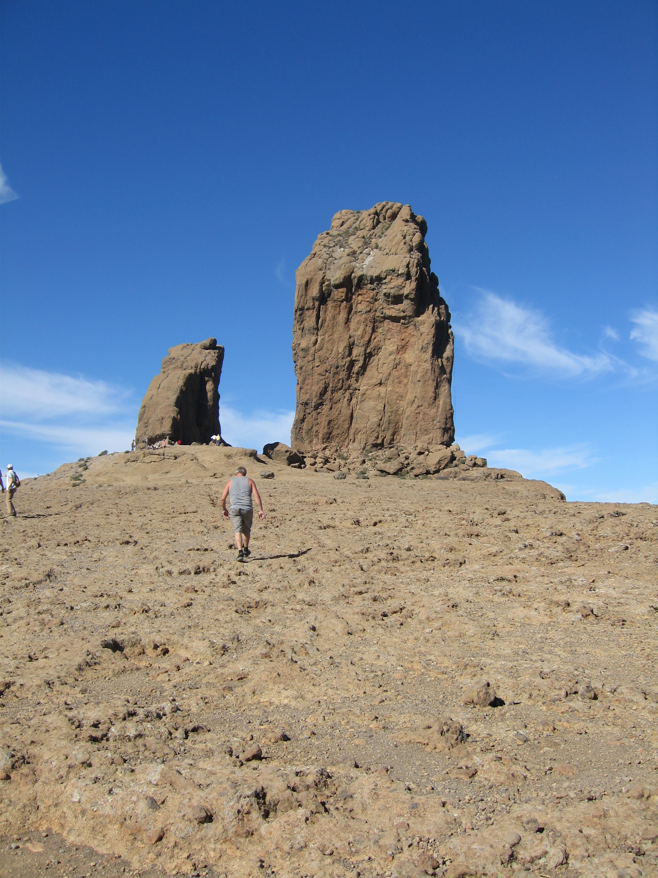
| | | | The first one, and the more prominent of the two, is Roque Nublo, perhaps best translated as “Cloudy Rock”. It’s a monolith 80 m (262 ft) tall. Its elevation of 1813 m (5948 ft) makes it second in height on the island, just a bit lower than Pico de las Nieves and 93% of its height. As the picture shows, it’s a popular hiking destination. I don’t know anything about its little brother next to it, but the two together make identification very easy. When I was flying to Tenerife later, it stood out as identifiable more than anything else, and was also visible on the flight back. Pico de las Nieves, on the other hand, was just another ridge somewhere. | | | | The other famous landmark is Roque Bentayga, which is also very distinctively shaped, and easily recognizable. Its height of 1412 m (4633 ft), which puts it at 78% of Roque Nublo. Both monoliths however stand out visually from most places in the valley, and both were worshipped by the Guanches in pre-Spanish times. Note, by the way, the confusion of mountains and valleys in this Tejeda crater, the winding mountain road on the lower left, and the village of Tejeda at the bottom of the picture. This is a closer picture of Roque Bentayga and Tejeda. | | | | Now that the reader knows what to look for and to identify within the panorama, this is the view of Tejeda crater and valley from Pico de las Nieves, looking west. Start at the left with those Canary Island pines, many of which have been part of the reforestation program. Now that the reader is educated as to the landmarks, one cannot miss Roque Nublo, which approaches eye level at this height. You also can’t fail to find and recognize Roque Bentayga, plus the winding mountain roads above the village of Tejeda. If you also look in the high distance to the right of Bentayga and at its same height, you can see the village of Artenara, and the road leading to it. It’s the highest village on the island, and will be discussed shortly. In this picture, the Parador I’m headed for is hidden behind hills to the right, but has views of both rocks and everything else. | | | | But I haven’t mentioned everything. What I’ve described so far is just--for me--50% of what this fabulous view is all about. This is a Wikipedia picture, but is just as clear as what I saw, and includes everything I saw. What can you see that I haven’t mentioned yet? (Hint: check out the horizon.) | | | | As you look toward the horizon, you see water, as I did that day, and for my whole stay at the Parador. Beyond the water, this being a clear day, you see Teide in all its glory, and with it, the entire island of Tenerife from north (right) to south (left). It was fabulous, and was a view we were never able to get on the first visit. | | | | Even though it’s over on the next island, we might as well introduce Teide now and talk more about it later. Teide (TEI.de; EI as in EIght, E as in cafÉ) is the highest mountain in the Canaries. It is the highest mountain in all of Spain (just like Pico in the Azores was the highest mountain in all of Portugal). And, although I haven’t seen it mentioned anywhere else, since this is all about Atlantic Isles, it’s the highest mountain in the Atlantic. Pico is 63% the height of Teide; Teide is 158% the height of Pico, in other words, more than half again as tall. I call Teide King of the Atlantic. More later when we’re on Tenerife. | | | | Getting the view was a wonderful start to the visit, but then I proceeded to backtrack down from the mountain to the Parador, which was not very far away. It’s located right in a modest mountain pass, at the far side of the bend of a hairpin curve. Its road location gives you a wonderful feeling of being in the center of things. As you stand at the curve with your back to the Parador, you can see where the road on the left of the hairpin splits, part going down to “Matt”, “Bridget” and Las Palmas, and the other part going over to San Bartolomé (“Bart”), while the right side of the hairpin continues down to the town of Tejeda (te.KHE.da) and the entire valley. The height of the pass, and therefore of the Parador, is 1560 m (5118 ft), so you’re well up in the mountains, surrounded by those pine trees everywhere. And this is only 35 km (22 mi) from Las Palmas. | | | | The Parador is not named directly after the town of Tejeda somewhat below in the valley, but after the pass the Parador’s located in, which is called Cruz de Tejeda (Tejeda Cross); thus the name is Parador de Cruz de Tejeda. Apparently there had been a crucifix put up in the pass in the 17C for orientation purposes, given the central location of this pass and roads leading in all directions. In 1960, a new cross was erected in front of the Parador in order to return sense to the name of the pass. That cross is not visible in this picture of the Parador, but let me describe what is there. The hairpin curve in the road is immediately to the left of this view. The rather goofy façade of the Parador, as I understand it, is the remaining structure from the older building dating from 1937, when a pseudo-medieval look was apparently sought. The arches and tower in the wall are kind of fun, but just sit in front of the Parador. The facility had apparently been closed for many years, and just three years ago, a totally modern building was put up behind this façade. | | | | What’s important to try to visualize in this picture is the view through the two trees on the left, a view which plunges down into the Tejeda valley. Since the Parador continues to the right, most of its rooms have that same exquisite view, similar to the view from Pico de las Nieves, but just not as high. Since the building is in the pass, it overflows it. That is, when you enter it, you’re on the third floor, and the other floors are down the slope. I had to take the elevator down to my room on the second floor. When I got there and checked the view from my balcony, it couldn’t have been better. You couldn’t see Pico de las Nieves to the left (no loss), but at eleven o’clock was Roque Nublo, at one o’clock Roque Bentayga (both higher than me), and at three o’clock was Teide across the channel, and this viewed lasted the three nights I was there, including some nice sunsets. This is a somewhat commercial-type video of Parador de Cruz de Tejeda. | | | | My middle day, to vary the visit, I went down the mountain to Las Palmas, and I’ll talk about that in a moment. My third day was a more extensive drive up top, essentially playing follow-the-dots. I went down the road to Tejeda, and drove up to the base of Roque Bentayga. A convenient road showed up to San Bartolomé, so I followed it. As it reached the point of changing from one crater to another, a chink had been cut out of the crater rim for the road, and I just liked how that looked. I went down partially to see how San Bartolomé clung to the slope, and to see the view down to Maspalomas on the coast. Backtracking, there was a turnoff to Roque Nublo, and I watched how, even then, hikers started up the path toward it. At this point, I wasn’t so far from the top of Pico de las Nieves, so for the second time I went up there, especially now being more familiar with the layout of the valleys. The road returned to the Parador, and I just continued around the hairpin curve, and once again passed Tejeda, on my way to Artenara, mentioned earlier, the highest village on the island at 1230 m (4035 ft). | | | | Miguel de Unamuno was one of the most respected authors and philosophers of Spain. He is particularly well-known for having been Rector of the University of Salamanca. In 1910, he visited Gran Canaria, and was so impressed by the chaotic nature of the landscape of the Tejeda caldera that he made a statement about it that is quoted to this day, and which is on a plaque in front of the Parador: | | | | | | “. . . y parece todo ello una tempestad petrificada.” |
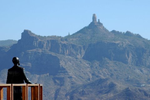
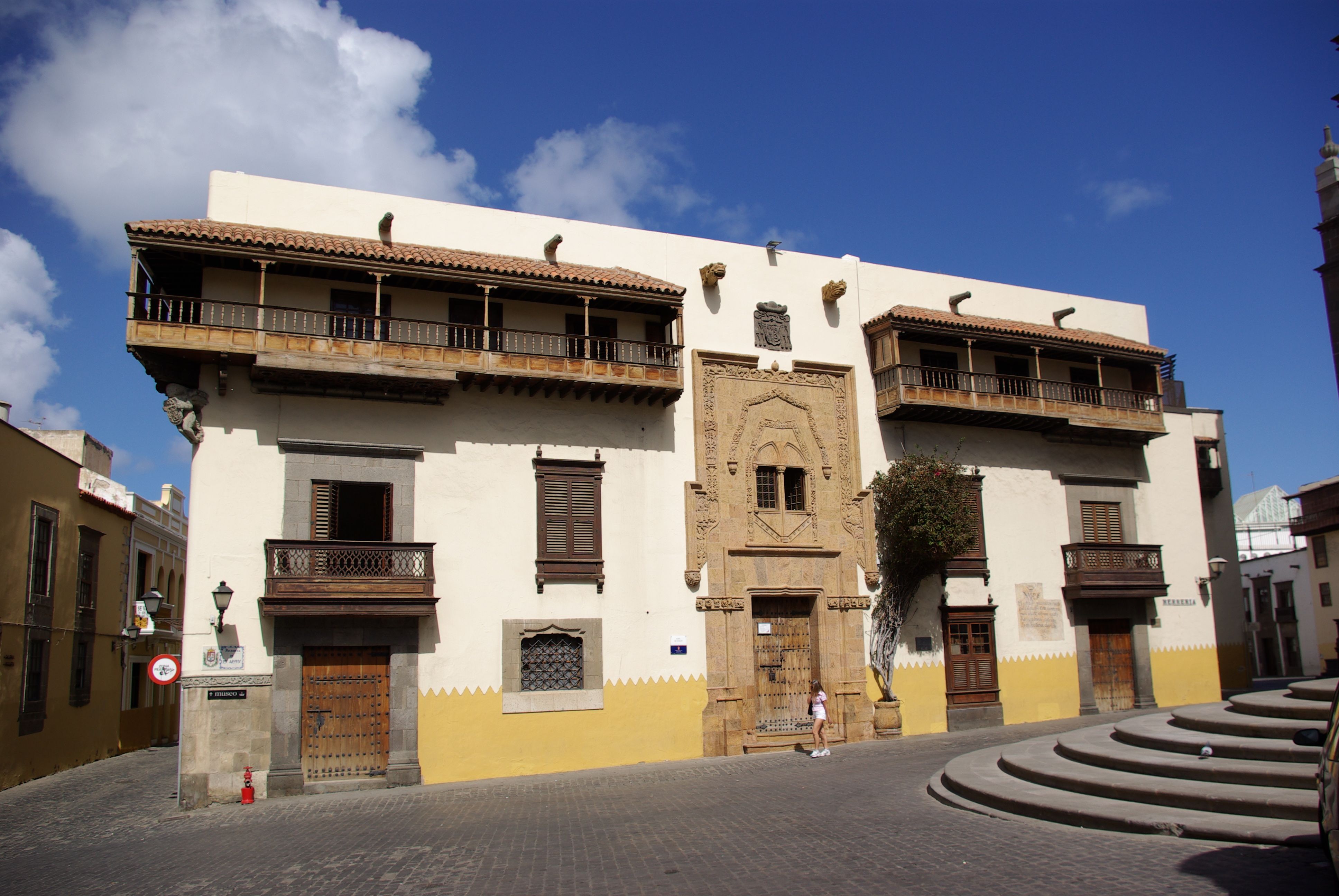
| | | | I translate it as “. . . and it all looks like a petrified storm.” If you want to sound more poetic and make it resemble the Spanish more closely, make it a “petrified tempest”. Knowing that he made that very accurate statement, apparently when he was in Artenara, I wanted to visit the town. A second motive was to see the unusual monument put up in 1999 in homage to Unamuno’s 1910 visit. It’s called the Balcón de Unamuno / Unamuno’s Balcony, and shows Unamuno contemplating the landscape. The “balcony” is a projection off one of the streets above a slope, and you can walk around to see the statue’s face, but it’s meant to be seen from behind, so that you can admire just what he was admiring. What a clever way to commemorate the classic designation of this “petrified storm”. | | | | “Down Below” As mentioned, my middle day was plunging into the world of the autovía again, so down I went past “Matt” and “Bridget”, got onto the first couple of autovías, then connected to a couple of others, which promised to get me to the boulevard separating La Vegueta and Triana. La Vegueta, on the south side of the boulevard, is where it all started, and to my mind, is the historical gem of the island, corresponding to the natural gem of the “up top” area. Triana, on the north side of the boulevard, is of similar age, but apparently has always been “the other side” of the old town, sort of a twin village. I wondered why there should be such a wide boulevard in such a historic area, and the model of the historic town in the Casa de Colón made it perfectly clear. I should have realized. Where the boulevard is today used to be the small creek on either side of which the twin villages were built in the 15C. | | | | I could not believe my luck. I was concerned about parking--what else--and if I’d have to maneuver around parking times and fees. Not only was parking free, there was parking along this entry boulevard, and a space was free steps from the cross street I wanted! I parked and just stared ahead for a while, since my day would be without further parking pressure and I could take as much time in La Vegueta as I wished. I went to the corner, turned right for just one block, and moved back several centuries, away from the autovías, back into the 15C, over half a millennium ago. | | | | La Vegueta You may remember when we talked about Las Vegas, Nevada, I said that “vega” was one of the Spanish words for a plain. Thus “vegueta” is a “little plain”, and that tells the whole story. The first Spanish settlers found a vegueta / little plain on the south bank of the creek and founded Las Palmas. | | | | La Vegueta and Triana are now just neighborhoods of Las Palmas, but La Vegueta in 1973 was declared a national historic district under the Ministry of Culture. In 1478 Spanish soldiers erected the Real de las Tres Palmas / Camp of the Three Palms, because of the three date palms that were located in the area. (Now, as we said, a palma is a regular palm and a palmera is a date palm. Do not ask me why the city is NOT Las Palmeras.) | | | | The historic district is as compact as any I’ve seen. La Vegueta extends for several blocks in each direction before becoming a more modern area. The nearby streets beckon and entice one to wander (how about a street called Calle de los Balcones / Street of the Balconies, with 18C buildings?). However, the main points of interest are Plaza Santa Ana in front of the Cathedral and the Casa de Colón directly behind the Cathedral. There were also two nearby squares I enjoyed. | | | | PLAZA SANTA ANA This is a bland picture of Plaza Santa Ana with the cathedral at one end and the City Hall behind you. I call the picture bland, because on my visit it was filled with local people--and I’m sure a few visitors--even though it was a weekday afternoon. There was a group of a couple of dozen costumed folk singers with many guitars, and a few drums. I say most people were locals (or at least Spanish), because they recognized the folk songs that were being played, and some started to dance in the street. It was very festive, which is not reflected in the bland photo. | | | | The thing I remember most, and still enjoyed most, were the bronze dog statues, which I cannot find a picture of to show. A description will have to do. There is a pedestrian street in front of the cathedral (I was parked one block away to the left). On the end of the plaza facing the cathedral, at the end of each row of palms you see, there were four bronze statues of dogs, a total of eight, each freestanding on its own pedestal. For some reason, the bronze was painted green (it was not oxidation). These dogs were apparently loved by all, because people were taking pictures of themselves, and particularly of their kids, hugging the dogs. In each group of four dogs, two center ones were further forward, and sitting up on their front legs, while the ones on the left and right were lying down, and set back a little. They were a little larger than life size, and, for some reason, in each group, three were obviously bloodhounds, with their big ears, and one seated one was a boxer, with short, pointed ears. The dogs are obviously to reflect the “Canine Islands” we discussed, and I have no idea how they decided to show three bloodhounds and a boxer in each grouping. But these dogs were certainly popular, and were a major memory of our first visit. | | | | TWO SQUARES Before going to the next major sight, Michelin guided me a couple of blocks to the side to see two squares, which I enjoyed a lot. Nearby, where two streets merged at an angle, a small, triangular square was refreshingly beautiful. It was tiny, so the stone fountain in its center was very tall, and the rest of the limited area will filled with flowers of every color. | | | | It was called the Plaza del Espíritu Santo / Square of the Holy Spirit, not necessarily a reference to any holy spirit, but to the church of that name on its edge. But the historical marker was even more interesting. It used to be called the Plazuela del Peso de la Harina. Now “plazuela”, or “little square”, is a better designation for the petite triangle than “plaza”. But the rest of the former name means “flour scale”. How much more charming and evocative of history it would have been to have maintained the name “Little Square of the Flour Scale”. | | | | Two blocks further was the much larger Plaza de Santo Domingo, also named after the church on it that you see, and much older and more historic. There were only a few locals about, and my memory will remain that I greeted and sat down on a bench on this square near an elderly lady with a cane, and proceeded to take out of my pocket some leftover cheese and bread from dinner the night before, and had a small, impromptu lunch in this very quiet, historic place. | | | | CASA DE COLÓN The Casa de Colón / Columbus House is not a residence Columbus owned. Much like the claim of buildings in the US that “George Washington slept here”, this is a matter of “Columbus slept here”, that is, at the Governor’s House, on his visits to Gran Canaria. The reason for his visit the first time was to ask for help in repairing the Pinta, and he apparently came back twice out of his three remaining trips. As I said in 2007/8, Columbus is a figure that you don’t often find tangible evidence for to visit, and on this trip I learned a lot more about the museum, since it isn’t just one house, as I now know. | | | | In the 1950’s a decision was made to make the Governor’s house that Columbus had visited into a museum, but it was a small house located on a very small block with about 2-3 other period houses. Since they wanted the museum to reflect not only Columbus, but the relationship of the Canaries to the New World, as well as including a library and research center, those several period buildings on that block were consolidated into what was called the Casa de Colón. Only now do I understand why the building has multiple façades and two charming patios. | | | | Not unusual for a street plan of this period, there are two simple façades facing quiet side streets and two “showy” façades facing more open areas. One showy one is the west façade. Just as Plaza Santa Ana faces the front of the cathedral, this west façade faces the back of the cathedral, illustrating how compact this area is. The round steps to the back entry to the cathedral are visible at lower right. This façade has one grand entryway and a couple of smaller ones, and it’s difficult to tell how many buildings were joined here to make the Casa de Colón. The quiet street to the left is the Calle de Colón / Columbus Street, with the simple north façade of the complex, but also at the far end of this street is the entrance to the museum, at the actual Governor’s house. | | | | The other showy façade is the south façade, with the cathedral casting its shadow at the left. The fancy entryway is the Portada Verde / Green Entrance, which must have been to one of the other town houses. This side is on the Plaza del Pilar Nuevo. If we make our way around the building to the right, down that narrow street with the undistinguished east façade, we’ll come to a sign in stone on the wall near the entrance to the museum that says that “El gran navigante Colón hizo escala [made a stop] en Gran Canaria en el primero (1492), segundo (1493) y cuarto (1502) de sus viajes al nuevo continente” and stayed in this house. I hope you get the gist of the message. | | | | But why should the governor’s house have been on this northeast corner of the block at the intersection of two otherwise uninteresting streets and façades? This is where I learned more, and it got more interesting still. It involves this tiny little square and the chapel of San Antonio Abad (rhymes with “a bod[y]). As you face this chapel, your back is to the quiet corner of the Casa de Colón, so tiny is the square. | | | | The first thing I read on the sign about the chapel is that, old as it is, it replaced an older church. Fair enough. But then I had to smile when I read another sign: “En este santo lugar oró Colón.” / “In this holy place, Columbus prayed.” Again, it’s like “George Washington slept here”, and across the street, they could actually say that Columbus did sleep there, but here they wanted their bit of fame as well. The only thing is, they had to choose their words carefully, since the church Columbus visited was that first one, not this chapel. So they instead refer to “this holy place”. I find that desperation for fifteen minutes of fame cute. | | | | But as you read the sign, you learn so much more, which passers-by that don’t read signs totally miss. THIS was the square where the city was founded. THIS was the square that had had three palm trees. That previous church was the original tiny cathedral. Old as the present cathedral and Plaza de Santa Ana are, they are johnny-come-latelies that replaced this (original) church and this little Plaza de San Antonio Abad. And that’s the reason why the Governor’s house was on the corner of this square. I found it so delightful to learn that, given how quiet and unobtrusive this little corner is. | | | | Then you turn around and enter the museum, which, to the credit of Las Palmas, is free, and you first enter that beautiful petite, wooden patio I remember. There’s a tiny fountain and plantings in the center, and benches to sit around, underneath the upper gallery, which looks down upon the fountain. Unfortunately, I couldn’t find any good pictures of this charming patio. However, immediately next to it (and obviously part of the next house) is the Patio del Pozo / Patio of the Well. This stone patio is about the same size as the wooden one it adjoins (door on left). | | | | This room shows maps, and other information, of his voyages. However, I show this picture primarily because of the ceiling, which is typical of the unusual ceilings in the house, some of which were coffered. It explains that caravels, the style of his ships, were designed originally by Arabs as fishing boats, and were converted later to ships of exploration and cargo. One map, made after his first voyage, shows North America labeled India Superior / Upper India, South America as India Inferior / Lower India, and Florida labeled as Catay / Cathay (China). A nearby room showed a reconstruction of a room on the Niña, almost full size, which represented the “Admiral’s Quarters”, labeled la Cámara del Almirante de la Niña. | | | | I particularly enjoyed two models. One was the one pictured earlier of the entire island of Gran Canaria, and I learned a lot, particular about the “up top” area. The other very enjoyable model was of La Vegueta, in its early days. This is where I learned that the boulevard had been a stream. It showed that the town hardly reached six or seven blocks in each direction, as did Triana on the other side of the stream, then came the fields. Pressing different buttons illuminated the important locations one at a time, such as the cathedral and Plaza de Santa Ana, and I was glad to see it showed both those other squares I’d wandered off to see, and particularly Plaza de Santo Domingo, which was apparently of quite some importance. This model just summarized the whole visit to La Vegueta so nicely. | | | | Las Palmas I suggest that any reader planning a visit not go beyond La Vegueta, since the newer parts of Las Palmas, while quite attractive, have nothing that any pleasant Spanish city doesn’t have. But for the sake of nostalgia, I wanted to go see the neighborhood and hotel we’d stayed at, so I plunged in to the fray. | | | | This shows Las Palmas quite a bit north of La Vegueta and Triana. The hills coming down on the left show why the city is stretched out in so long a strip along the coast. Those mountains are on the La Isleta peninsula, the waters to the right of it are the harbor, and to the left of it, the city beach, the area where I was headed--with trepidation, because of the now more complex road system. | | | | I drove to the end of the boulevard to get on the GC-1, which ran along the harbor, and promptly ended up in the wrong direction. After couple of exits, I was able to turn around and head downtown. I’m pleased to say this was my only mistake. I found the right exit, and drove into town. | | | | I was astonished. The city had shrunk. I remember wide avenues and little traffic. I found myself on attractive, tree-lined streets, but they had only two lanes, one for driving and one for parking. The difference between this and some other small towns I’d driven through recently is that the sidewalks were really quite wide. Still the total width of the street between building lines was still, shall we say, compact. Of course, all streets were one-way, yet I made it to the Hotel Concorde, where we’d stayed. Again, I remembered space, where there was crowding. I stopped, illegally, for three minutes in a spot, ran into the lobby (which I didn’t remember, but I did remember the breakfast room on the roof, which had great views), and ran to the corner to glance at the busy beach. The hotel and its neighborhood were great for us then, even with a car, but I wouldn’t recommend anyone staying in downtown Las Palmas today, and certainly not with a car. | | | | A few more one-ways, and I magically found my way to the GC-1. When I was back down in La Vegueta, I figured I’d turn onto that boulevard and retrace my steps. It worked, but not as I’d expected. When I turned off the GC-1, I found myself in a tunnel underneath the boulevard. What if I’d wanted to visit La Vegueta in this direction? When I left the tunnel, I was on the next autovía up to Santa Brígida, then the roads to San Mateo (thanks, Bridget and Matt!), and back to the Parador. After my third day driving up top, they again guided me back down to the airport to fly to Tenerife.
| | | |
| |
|
|
|

