|
Reflections 2014
Series 19
December 1
Canada Redux IV: Cape Breton Island
| | We've just left Charlottetown, and then Prince Edward Island over the Confederation Bridge, since, at this time of the year, the ferry, that's really closer to where we're going, doesn't run often enough. Let's get reoriented with the green map of Nova Scotia:
http://www.wtcchalifax.com/site-tcl/media/wtcchalifax/Nova%20Scotia%20Map.jpg
| | | | You see the ferry to Pictou, but we came over the bridge, through NB, and down to Truro. It's worth commenting at this point how central Truro is to everything. We passed through it on the train to Halifax. We came back to it for the tidal bore. We've now essentially done a round-trip to PEI out of Truro. We'll now do a round-trip to Cape Breton Island out of Truro. Only at the end, when we go to the Annapolis Valley and the Bay of Fundy will we return directly to Halifax and not via Truro. You see how close we go to Pictou, but the ferry wait would have made the trip just as long. | | | | Cape Breton Island Follow our route out to Cape Breton Island to a point where you see a connection between Aulds Cove on the mainland and Port Hastings on the island. Remembering that this green map, while quite good, is atilt, so that north is actually indicated by Cape North in the upper right, putting Louisbourg, a later destination, very much to the east, as well as the town of Canso on the mainland. It's Canso that gives its name to the very narrow Strait of Canso that separates Cape Breton Island from the mainland. | | | | To quickly review the outlets of the Gulf of St Lawrence (Map by Benoit Rochon), the semi-enclosed sea that is the world's largest estuary, there are three. The St Lawrence River, emptying the Great Lakes, enters at 8 o'clock, and faces these outlets: the mid-sized Strait of Belle Isle, 17 km (11 mi) wide, that we discussed in Newfoundland and Labrador (2013/12) appears at 1 o'clock; the broad Cabot Strait, a hearty 104 km (65 mi) across which there is ferry service to Newfoundland, is at 3 o'clock, and the narrow Canso Strait, exaggerated here for visibility, a mere 1 km (0.6 mi) wide, is at 4 o'clock. The narrowness of this strait is one of the many geographic curiosities of Cape Breton Island, and that above-mentioned connection across it has come to me to be a major source of irritation. | | | | I've driven across the Canso Causeway every time I've visited Cape Breton Island, and it never struck me before this trip what a crime against nature this structure is. Obviously, I learned a lot more about it now. Up until 1955, both road and rail traffic was ferried across. At that time it was decided to have a fixed link. | | | | Bridges are spectacular edifices, and people will go out of their way to see them—and we just came from the Confederation Bridge. Tunnels are efficient and evidence minimal disruption to the landscape. An elevated causeway, with frequent support pillars—much of the Confederation Bridge is just that—is more intrusive but at least allows for the free flow of waters. The Canadian government built none of those here. To save money, they blasted ten million tons of rock from a nearby mountain and dumped it in a line across the strait, resulting in a hideous rock-fill causeway (Photo by Sxjxcx) rather than an elevated causeway. This picture is from the island side, and shows how the mountain was defaced as well as the jagged-rock results blocking the strait. On this 1,385 m (4,544 ft) stretch, they built a two-lane roadway and a one-track rail line. On the island side of the causeway, they allowed for the Canso Canal to cut through for shipping, as well as a swing bridge, the Canso Canal Bridge, to regulate rail and road traffic over the canal. We'll use this picture of a lighthouse, unusually located next to a tiny old cemetery, to show the canal and bridge in the background (Photo by Dennis Jarvis)—click to see the canal a bit better. | | | | Thus the Strait of Canso, free-flowing for millennia, was permanently blocked in December 1954. The Causeway no longer permits exchange of water between the Gulf of Saint Lawrence and the Atlantic Ocean at this point. This outlet has suffered its fate because of its narrowness. Fortunately, the two larger outlets are still functioning normally. This aerial view of the causeway (Photo by Swampfoot) from the island side looking back to the mainland, also shows a bit of the canal and bridge in the foreground. | | | | The causeway blocking the strait has had environmental effects. While the Gulf side of the strait continued to freeze over in the winter, the Atlantic side became ice-free, and an ice-free port attracted several industries and created new jobs, a point politicians are quick to make. You can argue whether the end justifies the means, but other significant environmental damage was done because of the alteration of the tides on both sides of the causeway, having an effect further back into the Gulf. Damming the waterway for migrating fish was a problem for decades until some of the species were able to figure out how to go around Cape Breton Island the other way 'round. The causeway also allowed several non-native species of land animals to enter the island, notably the bobcat, which has slowly forced the more gentle lynx out of its traditional area and into the Cape Breton Highlands in the north. | | | | We discussed earlier the catastrophic alteration—since relieved--by the Canadian government of the Petitcodiac River and its affect on the tidal bore in that river. We can add this as ham-handed instance as Number 2, and have two more examples in the Annapolis Valley coming up. I discussed these situations afterward with a lockmaster and an engineer (we'll point that out in due time), and each agreed with me that none of them were good ideas. | | | | Start thinking now why a sea-level canal would need a lock in it, as this one has. We'll discuss it when we talk about the St Peters Canal shortly. (Hint: the gates, Janus-like, face two ways.) On the map you'll see it's not very far at all from the causeway to Saint Peters and the Saint Peters Canal, our next stop and topic. But the story of St Peters is intertwined with the curious geography of Cape Breton Island, so we'll discuss that first. | | | | Some might be unaware that "Breton" applies to the people and language of Brittany: people from Brittany are Bretons and many of them still speak Breton. Some Bretons were apparently here early on, and left their name. But for me this results in some confusion. This is how my thinking ran at first: | | | | | | Cape Breton Island. I see the island, but where's the cape? I never thought about it before, and now I cannot find a Cape Breton anywhere on the map, nor any reason why an island should be named after a nonexistent cape. If you want information on the cape, google "Cape Breton" expecting an answer like "Cape Breton is a cape located . . ." and the best you'll get is "Cape Breton is an island located . . ." Apparently "Cape Breton Island" can be used with or without the last word, and still means the same thing. Crazy. The only thing I can speculate is that, at the extreme northern point of the island facing the Cabot Strait, the major entry to the Bay lf St Lawrence, is Cape North, which we recently saw on the map. Perhaps this might once have been called Cape Breton because of the activity of Bretons in that area, but I have no further basis for such speculation. |
| | | | Further contemplation on the subject makes me think that perhaps maybe the entire island HAS actually been thought of as a cape. But capes are "bulging coastlines". Think of the coastline along Cape Cod, Cape Hatteras, the Cape of Good Hope. Was one of the coasts of this island considered a cape? Which one? I don't see it, and the answer to this question remains murky to me. | | | | So far, this island is notable geographically because of (1) the particularly narrow strait that sets it apart from the mainland, and for (2) its peculiar naming after a cape. But wait. We've got more. Look at the green map and trace by eye the shoreline of Cape Breton Island, keeping in mind that this is a trick question, so look for unusual twists and turns that may—or may not—change your answer. | | | | In greatest likelihood you traced around the northern peninsula with the Cape Breton Highlands, and then around the O-shaped lower part of the island. And you'd be wrong, because you'd be leaving out a huge area of ocean coastline in the CENTER of the island. The fact of the matter is that the island is shaped like a backwards J, with two distinct (though small) natural openings in the north that allow for a change of seawater with the waters of what is called Lake Bras d'Or, which is saline, though less so, than the ocean, since it has freshwater streams flowing into it. | | | | Now of course, most people don't think that way. They think subjectively that the lake really is a lake, disregarding its saltiness, and that its edges are lake shoreline, not seacoast, so that would have to be the de facto answer. But the technical, de jure answer is that the lake is really a huge bay, or inland sea, of the Atlantic Ocean filling the center of the island, and that the seacoast is a lot longer than it seems at first. Most people avoid the issue by simply calling it the Bras d'Or and not getting any more specific than that. | | | | You're sure to be dubious, so look at this map of Bras d'Or "Lake", shown in lighter blue than the real lakes. Find the causeway, and Saint Peters, where we are at the moment. Now look at the center of the "lake". You can see why some people call the bay the Bras d'Or Lakes, plural, because of the narrow isthmus, the waspwaist, that almost cuts it in half. But avoid making that plural error, since the isthmus simply divides the bay into two basins. Look up at Baddeck, where we'll be later, and find the major channel that connects the bay with the ocean. Then, to its right, find the much broader channel that squeezes down to a much narrower width toward its mouth, which has to considered the minor, or secondary entrance and exit. Also note that massive island between the two channels, Boularderie Island. Technically, it's a separate island and not part of Cape Breton Island, but don't try telling locals that, since subjectively it's all the same. I've always been curious about these two outlets and we'll inspect both carefully when we're up north. Finally, give one last look at the town of Saint Peters on its narrow, narrow isthmus, and you'll see why a canal was dug there, to create a third, man-made outlet from the Bras d'Or, and at the opposite end, at that. | | | | Summarizing local quirks about Cape Breton Island, we've now added (3) the lake-cum-bay. And we still have one quirk to go. Quirk (4) also relates to that body of water, the Bras d'Or. Where did it get its name? Unfortunately, that answer is not totally clear, so we'll have to look at the two choices and speculate a bit. Those who are language-inclined will feel they have the answer tout de suite. It's French, right? Piece-by-piece it's "arm-of-gold", so we translate that as the Golden Arm. Why gold? Nice sunsets? Those can be anywhere. And where's the arm? The Oxford Dictionary says an arm can be a "narrow strip of water . . . projecting from a larger body". I think of the fjord Tracy Arm in Alaska. But this is a large bay/lake, not a narrow strip of water. And if the larger entrance in the north were the arm being referred to, that wouldn't make sense, since it's a strait, not an arm, and arms are dead-ended. That theory is accepted by many, but it's illogical and simplistic, and most likely came about by error, through folk etymology. | | | | The more logical theory unfortunately lacks a firm foundation. Do note that Bras d'Or is pronounced bra.DOR. On maps dating to 1872 and earlier, the body of water is called Le Lac de Labrador, or even shortened to just Labrador. The firm foundation that is lacking is precisely why it should have the same name as Labrador, but some places are named after other places. It does seem to be the true derivation of the name. The folk etymology involved would be people hearing that name and deriving Bras d'Or out of it. It would seem that the people making the mistake would not have likely been francophones, but anglophones, because a francophone would automatically know that it's le bras, not la and wouldn't have gone that route. On the other hand, it's easy to picture late 19C anglophones romanticizing a French phrase out of one that didn't seem to make sense otherwise. That's how folk etymology works. | | | | | | Curious developments in place names involving the French word la are not unheard of, and we saw one in 2013/12, condensed here. There's a village named Brador on the Québec side of the border with Labrador, but in an area that was still part of the traditional "Labrador Coast" or Côte de Labrador (old spelling: coste). But in documents from the 17C and 18C, there was an error made in the French name, where one word was misunderstood as two, involving la, so the area was written as coste de la Brador. From this misinterpretation, the village of Brador got its name. That village stayed as Brador, but here the misinterpretation went further, to Bras d'Or. Go figure. |
| | | | Saint Peters Canal I had almost forgotten about St Peters and its canal. It was just while reviewing our travel diaries preparing for this trip that I noticed we'd discovered it and stopped there in 1984, but just in passing. This time I wanted to look into it more deeply and booked a room for two nights at the Bras d'Or Lakes Inn, right near the left bank of the canal. That would leave me a full day to see the canal, plus sit back and relax, and get some writing done.
| | | | We are far from the first to note that this isthmus is so narrow, and that the waters of the Bras d'Or came SO CLOSE to the Atlantic Ocean (at the Strait of Canso), but never quite touched it—absent the hand of man. I learned the following, first, I must emphasize, from onsite signs and historic markers, then supplemented by online research. | | | | The local Mi'kmaq had long used the narrow isthmus as a portage to carry their canoes between the Bras d'Or and the ocean. I continue to find it intriguing how, in North America, indigenous trails become modern roads, and in this case, a canal. Just note who was here first, folks. The first European settlers were the Portuguese, way back in the 1500s, who so frequently were to be seen in what today is Newfoundland, Labrador, and the Gulf of Saint Lawrence. They founded in the isthmus the town of Santo Pedro, from which the current name is derived, as a trading and fishing post. Thus St Peters is one of the oldest European settlements in North America. However, it was abandoned by the Portuguese in the early 1600s. | | | | | | As I write this (in my roomette on the City of New Orleans, training from that city to Chicago), there comes a flash of insight. I invite the reader to refer back to 2013/10 and to Find (use Ctrl-F): Naming Labrador It shows how and why the Portuguese word lavrador developed into the place-name Labrador. Well, if the Portuguese named THAT Labrador, and the Portuguese also founded Santo Pedro here—and now here's the speculation—could they also have named this body of water in the same way? Is that why the name appeared on those 19C maps referred to above?
If that is true, is this original research we've just done? Have we found the missing link disproving French origins of the name? |
| | | | The abandoned Santo Pedro was later taken over by France, when a small fortified settlement, with the translated name of Saint-Pierre, was built by French merchants from La Rochelle. In 1650, Nicholas Denys from Tours (there are several monuments to him at the canal today), took over and encouraged fishing and trading and the fur trade with the Mi'kmaq. Next to his fur trading post, he transformed the Mi'kmaq portage trail across the isthmus into a haulover road to move small ships, hauled by oxen, overland on wooden skids between the bodies of water. In the early 1700s, France, having lost the mainland of Nova Scotia, began moving some Acadian colonists here to increase the population. They named the harbor adjacent to the fortified Saint-Pierre Port Toulouse. But the British eventually took over, and, if you refer back to the map of Acadian communities affected by the later British deportations, Port Toulouse is one of them. | | | | By the early 1800s, the British reestablished the village of St Peters, once again just translating the name. The locals rehabilitated Denys's old haulover road to portage small sailing ships. This route was considered much shorter and safer between the south and Sydney in the north than sailing along the exposed outer coast. I saw a sign that explained that remnants of the haulover road were still visible at the beginning of the 20C, but were lost during later widenings of the canal. Sic transit (pun intended). | | | | Finally, building a canal here was looked into and construction began in 1854 and lasted 15 years. Despite the short distance involved of only 800 m (2,625 ft--about a half-mile), work involved digging, blasting, and drilling through a solid granite hill 20 m (66 ft) high to build a canal 30 m (100 ft) wide. The canal opened in 1869, just as industry began to expand on Cape Breton Island. The canal saw moderate to heavy use by small coastal steamships and barges. The inland route was particularly useful during the World Wars to avoid enemy shipping in the Atlantic. | | | | The federal government eventually took over the canal, and it's operated by Parks Canada as a National Historic Site. Currently, much commercial shipping avoids the canal, one obvious reason being that today's ships are too large to fit. The canal is today used mostly, though not entirely, by pleasure boats, with about 1,000 transits a year, and is open only in the warmer months. When I was there in late May this year they were just getting ready to open for the season. | | | | So we drive into St Peters and across the small town to the east side, where we pull into the parking lot of the Bras d'Or Inn. Copy and paste this link:
http://images.marinas.com/med_res_id/113192
| | | | We are looking north here, where the Canal leads into St Peters Inlet on the Bras d'Or. We're seeing here maybe one-quarter of the Canal. We've come in from the left, and you see the parking lot--the Inn is to the left of the trees. We'll check out later the two roads leading towards us off the main highway, one on each side of the canal. The left one is the main one leading down to the lock, and is called, sure enough, Denys Street. The other one is a park road in the Battery Provincial Park, which encompasses much of the area on the right. The grassy path to the left of the canal we'll walk round-trip tomorrow, from the far end behind us to the south, then under the bridge, and to the northern end in front of us here, to see the pleasure boats docked there. We'll use that white swing bridge to go on to Louisbourg when we're done here. | | | | A sign at the bridge says it allows for a 6m (20 ft) clearance. It's operated from that little black bridge house on Denys Street. This is the fourth swing bridge on this site, installed in 1931. A local sign says it had been a railroad bridge in Ontario. (!!) | | | | I can't imagine my luck in finding this picture, which is even better and more helpful than the last one. Copy and paste:
| | | | Beware! It's upside-down, that is, north is now behind us, but we see all of the (short) canal and much beyond. We're above St Peters Inlet on the Bras d'Or and can see the other end, which is St Peters Bay on the Atlantic. You can see why the town calls itself "Where the Ocean Meets the Inland Sea" (and not "Lake", by the way). | | | | On our day to actually see the canal, we leave the Inn, which is the large red building on the right, and cross the swing bridge just to get the views, but then backtrack and go down Denys Street to the lock area. There are monuments to Denys, and lots of historical markers. We walk into the Visitor Center, which is attached to the Lockmaster's House, and someone asks if he can help. It turns out to be the Lockmaster himself, so we sit down in his office (an advantage of the quieter pre-season) and have a lengthy chat. This is where he agrees that blasting a mountain to build the Canso Causeway was a bad idea. | | | | He's the one who suggests we walk the full length of the canal on the grassy path, most of which is visible in the picture. We find that this northern end is also a boat-launching area, and a historical marker says that the two grassy headlands we see on this side are man-made, from fill from digging the canal, to protect from wind and waves. Returning to the southern end on the grassy path, seen on the left (Photo by Dennis Jarvis), we see pleasure boats docked on the Provincial Park side. Click to see the lock; the Lockmaster's House would be out of the picture, to the left. As you can see, you can walk across the closed lock gates between sides of the canal. | | | | But we drive back to the swing bridge and now go down the park road to picnic areas along the opposite side of the lock from the Lockmaster's House. Historic markers explain the importance of this area to the Mi'kmaq, and a footpath leads all around that distant headland in the Atlantic to the nice views at the Jerome Point Lighthouse, which has guided ships to the canal since 1875. | | | | We've discussed everything except why this canal should have a lock here, if it's a sea-level canal. If both sides are at sea level, why have a lock as a barrier? It's the same reason why the Shinnecock Canal on Long Island, which we discussed in 2011/10, had a lock, and why the canal through the nearby Canso Causeway had a lock. All three are at sea level—all three have locks. | | | | It's the fault once again of our old friend, the Moon (the Sun, too). Tides are finicky. The tide on one side of the lock may rise—in the present case, let's say on the Atlantic side--and may take a long time until that rise reaches the water on the other side—in this case, in the Bras d'Or. Because of this tidal activity on both ends of the canal there can be a difference of up to 1.4 m (4.5 ft) between the two sides, both at "sea level". If there were no lock, there'd be a strong, churning tidal flow running through the canal, churning more with a greater differential, less when it's less. And then it would reverse! If this sounds familiar, it would be the exact same situation on a man-made canal that occurs naturally at the Reversing Rapids ("Falls") in Saint John NB. | | | | For this reason, there are locks in these sea-level canals, and in St Peters, both ends of the lock have double-lock gates (Photo by Verne Equinox). This view is over to the Park side, and the roof of the Lockmaster's House is visible on this side through the trees. Click to enlarge to see how you can cross over walking on top of the gates, but also note that here there are FOUR pairs of gates: one pair at each end of the lock pointing to the left towards potential high tides in the Bras d'Or, and one pair at each end pointing toward the Atlantic, to the right. As it turns out, St Peters is the home of North America's oldest operating tidal lock canal. And it is just a coincidence that we are seeing this, since a tidal lock has nothing to do with the huge Bay of Fundy tides on the other side of NS, nor with tidal bores. | | | | One of my mottoes is to never pass by a historical marker or plaque without reading it—and sometime taking notes. This time it paid off nicely, proving a point I've made. Near the Lockmaster's House and near the information on Denys was a reproduction of a French map. It said the original dated from 1733 and is to be found in the Archives Nationales de France. Given the date, there are archaic French spellings—try counting them—in the title: Plan de partie du Port Toulouze dans lisle Royalle, so it's a Map of Part of Port Toulouse in Île Royale. | | | | Along with showing the town, it showed a bit of the bodies of water north and south. On the Bras d'Or side, this venerable map said "Extremité de la Brador". Once again, I rest my case. | | | | Sydney & the CBRM Our next stop is Louisbourg, and checking the green map of NS we see that the most direct route is to cross the white bridge in St Peters and continue up the Bras d'Or—a good idea in any case, because of the extensive water and forest views. We then have to change roads in Sydney. | | | | Sydney has always been an industrial area, particularly noted for its coal mines--note on the map that a nearby town is actually named Sydney Mines. In addition, the former town of North Sydney is the base for both ferries to Newfoundland we took and that we've discussed. But industry here has been in decline for a long time, with closed mines and disappearing railroads. Remember that the underused track across the Canso Causeway was meant to service Sydney industry, and the railroad to Louisbourg meant to bring coal to a port less likely to freeze is also now gone. | | | | We've seen earlier how Canadian cities have consolidated other local municipalities to form new entities, and that's also happened here, albeit with a weird name. In 1995, Nova Scotia formed the Cape Breton Regional Municipality (CBRM). It's large, because it's based on Cape Breton County, which also accounts for the quirky new name. De facto, the county took over (see the map) Sydney, North Sydney, Sydney Mines (couldn't they have chosen the name "Sydney"? That's what I continue to call it, and others do as well, I'm sure), Glace Bay, New Waterford, Dominion, and, surprisingly, since it's further afield, Louisbourg. | | | | Louisbourg So, de jure we switch roads in CBRM, de facto in Sydney, and off we go to Louisbourg, a good half-hour further afield. Which brings us to the topic: why is Louisbourg located at the End of the World? (Map by Geo Swan) It would be very hard to go further off the beaten path, something that becomes even more obvious during a visit. The answer seems so simple and obvious once you figure it out. We're figuring accessibility via land. Louisbourg was built as a child of the sea. Just as three centuries later, ferries would connect North Sydney across the Cabot Strait with Newfoundland, Louisbourg was built to protect French accessibility to that very same Cabot Strait, and stands to one side of it. And to the other side, near Newfoundland? To this day, the pair of islands, Saint-Pierre et Miquelon (2013/10), belong to France, and at the time, served as a corresponding French outpost on the eastern side of the strait. Review that by copying and pasting this link, then clicking:
http://www.acls-aatc.ca/files/english/books/8.1.jpg
| | | | The Cabot Strait was the gateway, via the Gulf of St Lawrence and the St Lawrence River, to all of New France. Louisbourg, as the sentinel standing at the gateway, was extremely important. When it was lost, New France was lost. This seems particularly ironic and poignant when we consider that we're presently driving down a quiet road to what is, in shoulder season, a very quiet town, a town that seems to be at the End of the World, if not the End of Nowhere. | | | | The story of Louisbourg fits neatly into a half-century period of the 18C. The original French settlement, named for Louis XIV, was made at the south end of the protected bay-cum-harbor in 1713. The fishing port, used heavily for cod, grew into a major commercial port, which, between 1720 and 1740, was developed into a fortress, with fortifications that eventually surrounded the entire town. At this point, Louisbourg possessed, at great cost, one of the most extensive European fortification systems anywhere in North America, and it was manned by the largest garrison in North America. But there were many problems: the harsh climate, a boggy site, scarce building materials, corrupt officials. | | | | These fortifications, however, seem to have done the town little good, since there were two sieges of Louisbourg following completion of the walls, in 1745 and again—more seriously—in 1758, and the French lost both. (!!) The Siege of 1745, with the fortress not completely finished, involved a force from New England of 4,000, just down the coast, but backed by the British Navy. The siege was successful and the fortress capitulated after 46 days. However, the treaty three years later restored Louisbourg to France in exchange for concessions France made elsewhere. | | | | | | It should be kept in mind—it's so easy to forget this—that this was still three decades before American independence. New Englanders were still thoroughly British, so these were "American British" supported by "European British". There's a very interesting footnote to this "pre-American" involvement of New Englanders. While walking the grounds, I saw on a pedestal a replica of the Louisbourg Cross (the original was protected in a nearby building). It had been missing for 250 years, taken as booty by the New Englanders in 1745. It was later discovered to be in the possession of Harvard University, which, after numerous entreaties, agreed in 1995 to return it to Louisbourg "on permanent loan". The cross, which has symbolic and historic, rather than monetary value, is a simple wrought-iron cross with fleurs-de-lis, about 86 x 54 cm (35 x 22 in). It's believed to have marked a cemetery at the fortress, which explains the outdoor location of the replica I saw. While at Harvard, the cross was generally forgotten about after it had been stored, displayed, stolen, and had survived a fire that destroyed the documents explaining how Harvard got it. Speculation is that it was brought to the university by an alumnus who fought in the 1745 siege. History does have its twists and turns. |
| | | | But then came the definitive Siege of 1758. The British attacked Louisbourg, with 14,000 soldiers, 12,000 sailors and marines on 150 ships, while the French had 3.500 soldiers, 3,5000 sailors and marines, and 5 ships. After seven weeks, British forces captured the fortress once again, which ended the French colonial era in Atlantic Canada. To add insult to injury, the British then used Louisbourg as a launching point for the 1759 Siege of Québec, culminating in the Battle of the Plains of Abraham, and the taking of Québec. The loss of the remainder of French North America came the following year and thus New France disappeared from the maps. That's how important the loss of Louisbourg was. | | | | But the British were concerned that, just like after 1745, some future treaty could still give Louisbourg back to France once again, so in 1760, British engineers oversaw the systematic destruction of the fortifications of Louisbourg. The British kept a garrison on the town site until 1768, but it was then abandoned, and some of the cut stones from Louisbourg were sent to Halifax for reuse, and later, also to Sydney. After the military left, a small civilian population continued to live there for some time. | | | | | | Regarding Halifax: in 1749, shortly after the FIRST siege, the British were forced by the treaty to leave Louisbourg and turn it back over to the French, assuming they'd never return, which is why the New Englanders symbolically took the Louisbourg Cross with them. But still needing a base to work out of, they moved down he coast to Chebucto Bay and established a fortified town there that they named Halifax. This soon became the largest Royal Navy base on the Atlantic coast and also hosted British army regulars, and developed into the city it is today. But if things had gone just slightly differently, Louisbourg could have been what Halifax is today, possibly in place of Halifax, or possibly as its twin. Sic transit. |
| | | | Let's take this step by step, mixing the past with the present, starting with two maps from the past. First we have a French map of Louisbourg and its artillery batteries c 1751, which places this map in the period between the two sieges. We see the fortress facing the foot-shaped harbor. We see the Batterie de l'isle de l'Entrée (modern spelling: l'île), or the Entry Island Battery, cleverly placed to protect everything. Today, you see just rocks and shoals sticking out above the water when you stand on the adjacent Pointe de Rochefort. Across from the port entry we see the Batterie Royalle (modern spelling: Royale), also cleverly placed facing the port entrance, given that the fortress itself was off to the side. It's along this side of the port that the long, narrow modern town of Louisbourg lies. As a matter of fact, I'd go so far as to venture to guess that the (dirt) road shown entering from the upper right along this side of the port to the fortress is virtually the very same as the present (paved) road coming into town as Main Street, Route 22. My b&b is located right beyond where Main Street bends at those streams (one of them is still there, perhaps the middle one) to approach the restoration of the fortress. | | | | This map is turned so that north is to the upper right, but do note that the fortress is, as said, on the south end of the protected bay-cum-harbor. 4 km (2.5 mi) of wall surrounded the fort, most heavily on the western (land) side, where the walls were 9 m (30 ft) high and 11 m (36 ft) across, further protected by a wide ditch and ramparts. | | | | We also have this British map from between the sieges, which has the advantage of being turned properly to the north, so the lay of the land shows up more accurately. The heading identifies it, and speaks of surrender to the British in 1745 after the siege, so we can place it in time. It also identifies the Commander of the New England Forces and the Commander of "his Majesty's Fleet there", so we can see again that there were two participating groups. | | | | But the settlement within the fort was ultimately abandoned, and later other English settlers built a small fishing village opposite the fort, where we've shown the present town is located. Then, as we've seen before, the American Revolution had its usual effect of filling the new village with additional Loyalists in the 1780s. A century later, the Sydney and Louisburg Railway arrived in 1894, which brought heavy volumes of coal exports in the winter, when Sydney's port was frozen over, but Louisbourg's was ice-free. But as we've seen, in modern times, coal mining ended and the railroads disappeared. | | | | A curious additional fact is that the Canadian government ship Montmagny used Louisbourg harbor to land bodies from the sinking of the Titanic in 1912 (Map by Prioryman). We last used this map when, on the Greenland trip (2012/24), we discussed the sinking and the location. But if Louisbourg is located at the End of Nowhere from the landside point of view, both it and Newfoundland are directly adjacent to the ocean site of the Titanic sinking. | | | | The ruins of Louisbourg Fortress in 1907 looked like this. In the 1960s and 1970s, Parks Canada decided to reconstruct Louisbourg as a National Historic Site of Canada. It was impractical to reconstruct the whole thing, so a representative one-quarter of the town and fortifications has been rebuilt, using some of the original remaining stonework, as a living history museum with costumed portrayers. The representative time period chosen was when Louisbourg was at its height in the summer of 1744, the year before the first siege, and, though not realized then, the beginning of the end. The work of archaeologists, historians, engineers, and architects was involved, who were aided by unemployed coal miners from the region, many of whom had to learn French 18C masonry techniques and related skills for the sake of accuracy of the replica. This restoration is the most expense preservation project ever undertaken by the Canadian government. | | | | So I suppose you can call this Louisbourg's third stage of development. It's chance to have a major fortress and become a big city faded. It's chance to be a railhead and coal-exporting port has faded, although the restored railway station in town now reflects that era in the form of the Sydney and Louisburg Railway Museum. In recent decades, Louisbourg has been in its troisième âge, since the restoration is the town's dominant economic engine, employing many residents (in various ways, but most spectacularly, by role-playing and appearing in period costumes) and attracting thousands of visitors every year to this town of about only 1,000 inhabitants here at the End of Nowhere. | | | | You will have no doubt that Michelin gives the Fortress of Louisbourg the maximum of three stars, its distant location notwithstanding. One often has to travel to enjoy a quality experience. | | | | | | I mostly remember the fog. Beyond that, I had to consult the 1984 travel diary. It was the year we'd driven from New York to Newfoundland, and on arriving back on the ferry to North Sydney we drove to Louisbourg and spent two nights there at a venue on Main Street whose name I can no longer find on Google maps—it must have a new name now. Only now that I understand better the military connection between Louisbourg and St Pierre & Miquelon do I realize how appropriate it was that we visited St Pierre out of Newfoundland just four days before we got to Louisbourg. We spent the day touring the entire fortress, even though everything was in an absolute peasoup fog that had rolled in from the ocean! The diary reminds me that we visited all of the houses and theme areas, which is typical of how we'd always operated, and conversed extensively to the various depictors in costume. While I do not remember details, the overall historic, time-travel experience returns to me in toto. Again, I've been saying all these years, and it's absolutely true, that the experience of walking along a street in the dense fog and having costumed figures from the past appear out of the swirling mist, and then disappear again behind you once you've passed them, added invaluably to the whole experience at the time. |
| | | | Thus, in 2014, a revisit seemed appropriate, which turned out in perfectly clear weather. It was shoulder season, clearly explained on the website, which meant that there would be a limited number of depictors on site—I saw maybe 15 spread out here and there—and even fewer functioning exhibits. But I've seen blacksmiths before, and the shoulder season meant not only a reduced (40%) entrance fee, but far fewer other visitors to block out the view around you in the reconstructed streets; if I saw 40-50 visitors spread out across the restoration, that would be a lot. It's worth going in early June, which is still the shoulder season way up here at the End of Nowhere. | | | | | | It's worth summarizing the highly constricted season here. Low season is mid-October to mid-May, when it's open only weekdays, otherwise daily. The shoulder seasons are mid-May through all of June, and then again the second week of September to mid-October. High season, which they have to make the most of, is merely July, August, and the first week of September. That is, to use a show biz term, a "rough house to play to". |
| | | | Visiting Louisbourg So now, in early June, in pleasant, sunny but still jacket weather, let's all do some time travel to visit the Fortress of Louisbourg in 1744. Bouncing along the road from Sydney, we approach the modern town from the northeast (see the antique French map above), and the first thing we come to on Main Street is the former Sydney & Louisburg RW Station (note spelling), now, sadly, just a museum. It was built in 1895, and service ended in 1968. It's closed at this time of day, but let's pay tribute to this period of the town's history by looking at its website (copy & paste):
http://www.novascotiarailwayheritage.com/louisbourg.htm
| | | | | | It's time to let out a dirty little secret. For the three decades since we "discovered" and first visited Louisbourg in 1984, I've blithely—and foolishly—assumed that the name was pronounced lwi.BOOR. It's French, right? Well, no. The name Louisbourg is totally anglicized and pronounced as though written Lewisburg. As a matter of fact, it was written Louisburg for many years, as indicated by the name of the railway. But in 1966, the Nova Scotia Assembly voted to respell the name in the French fashion, presumably to go along with the restoration then in progress, which accounts for my slipping into lwi.BOOR. Oh, well. |
| | | | But we're in town, which doesn't seem particularly busy. Also, Main Street runs very close to the enclosed harbor (Photo by Dennis Jarvis). We come across 3-4 restaurants we've looked up online in the past, but all seem to be closed, except the last one, nearest the b&b, the Lobster Kettle, which has cars parked around it. A little further and we reach the Cranberry Cove Inn, a Victorian-style, cranberry-colored house from 1904, now a b&b. The common rooms downstairs have the usual Victorian charm, and all the guest rooms are named, and, as reported in the last posting on Green Gables, my small room with one partially sloped wall was called Anne's Hideaway. | | | | I asked the young man in charge about restaurants, and got a bit of a surprise. He said all the other restaurants in town were still closed for the season (it was early June!!) and, as a matter of fact, the Lobster Kettle had just opened a week earlier! On top of that, their opening hours at the moment ended at 6 PM! I suppose in shoulder season they were catering to a lunch crowd. What shocked me further was his saying that he could recommend a few restaurants in Sydney. Now to him, living at the End of Nowhere, Sydney was just a half-hour away, and not unreasonable. But I had no intention after having come all the way out here, to drive back to Sydney for dinner. | | | | It worked out very well. Both days, I went to dinner at the Lobster Kettle at an early 5:30. They were right on the harbor, with a nice view. While the décor was simple, the food was very good, and I was quite satisfied. In any case, it's best to dine locally. Take a look:
http://www.lobsterkettle.com/
| | | | The Restoration On our one full day in town, it's a very short drive from the b&b to the Visitor Center, but surprise! It's closed. Not to worry. I'd checked it out in advance, and I'd totally forgotten how things had worked when we were here in high season as opposed to now. At that time, and still today, probably because of the huge crowds, you pay at the visitor center, get in a shuttle bus, and are driven to the front gate. But I had read that, in off season and shoulder season, you drive yourself to the back of the restoration. Copy and paste to take a look:
http://www.fortressoflouisbourg.ca/app/trimapsImage600.png
| | | | Keep this, which we'll refer to as we go along as "the map". Then orient yourself. This is the south end of the harbor, so we're looking southeast, with the modern town behind us. Now when you're plopped down in real life into the restoration, you're immediately impressed at how HUGE it is! It seems to run on for blocks and blocks. The advantage of looking at this map first is that it's like looking behind the scenes and you can realize how SMALL the restoration really is! You don't really realize when you're there that the restored part of the town is only one intersection. Look at it. From the river gate, which is the Porte Frédéric / Frederick Gate, the street runs just two blocks inland. They don't tell you when you're there, but I'll tell you that that's Rue Toulouse. I can also tell you that it was never any longer than it is right now. And we have only two blocks of the cross street, which I'll tell you is Rue Royale. I'll also point out that we are looking at the end of it on the right, but that it originally ran several blocks further on the left. There are a few additional buildings to the left along the Quay, with just the very end of Rue Saint-Louis appearing between the first houses on the Quay—the rest of that street is just a dirt road with few to no houses today. And that's it for the town. As for the walls, only two bastions have been restored, but they give a feeling of absolute immensity to the site. In the foreground, next to the main entrance, the Porte Dauphin / Dauphin Gate right on the water, is the Demi-Bastion du Dauphin / Dauphin Demi-Bastion. On the right is the huge Bastion du Roi / King's Bastion. Even as you walk around and try to tell yourself how small the restoration really is, you have a feeling of being in a very large town. Funny how, in the mind, the part expands to represent the whole so fully. | | | | Hold on to this map for reference, but now let's look at the Forteresse de Louisbourg from ground level, from the approach road (Photo by James Sherar) (click). We'll refer back to this as the "harbor view"—if you want to copy and paste it, here's the direct link:
http://upload.wikimedia.org/wikipedia/commons/4/4f/Fortress_of_Louisbourg%2C_Louisbourg%2C_Nova_Scotia_02.jpg
Even from this distance, it gives a MUCH bigger and more impressive impression that reality proves. But that's the point, isn't it? We can see how the King's Bastion and its buildings on the right overlord the site, even the entrance at the Dauphin Gate in the foreground, which was the main gate at the time. The gold-colored Frederick Gate on the Quay, was the waterfront entrance, mostly used for the arrival of VIPs, is backed by what seems blocks and blocks of buildings, far more than there really are. Actually, there ARE more than 50 buildings on the site, with furnishings that are either originals or reproductions. But for one more look at reality, copy and paste the link to this website:
http://marinas.com/view/landmark/167_Fortress_Of_Louisbourg_NS_Canada
| | | | It's a little awkward to be viewing an entire website, but the first picture in particular is spectacular. We'll refer back to this as the "air view". By now you should be able to recognize both bastions, both gates, and the main intersection. Well, this is how our day started. Having driven past the closed Visitors' Center, we followed directions to take a dusty dirt road that led us around the entire site so that we entered from the top and are instructed to park in that gray, off-season parking lot. To the left of that lot we can see where Rochefort Point spreads out beyond the pond towards the harbor entrance. You should visually project the wall and two bastions in an arc to and along the water. There were four more bastions, and two more gates. The Queen's Gate and Bastion faced toward the back and so saw little use, but the Maurepas Gate and Bastion on the far end of the pond faced both Rochfort Point and the entrance to the harbor. This gate led to the fishing areas, more dwellings, and cemeteries, and was elaborately decorated, since it was very visible to arriving ships. All this is gone. But use this picture to judge how merely 5.7 ha (14 acres) are reconstructed of the 24.3 ha (60 acres) of the fortress and town, which comes to about 23%, roughly a quarter. Clicking on the thumbnails on the right will show more aerial views of the Fortress. | | | | From the parking lot we walk to the first house below it, where the off-season ticket office is, and we start our walk through the town. Do follow our route on the map and/or the aerial view. We're at the top of the two-block long
Rue Toulouse (Photo by Charny). As you can see, it leads downhill to the Frederick Gate on the waterfront. At the main intersection, we also inspect one block in each direction of Rue Royale. The half-timbered houses here are absolutely typical, and one building was open that explained the architectural construction, with sample openings in the walls and floors to be able to examine the construction. I learned here that half-timbering, common in Germany as Fachwerk, is called here building en charpente. That second word simply means "framework, woodwork", and I finally understood how simple this attractive construction, often called Tudor in English, really is. While we cover over frame construction with plaster, or, more likely today, with wallboard, this style leaves the framework totally exposed, with the spaces between the timbers filled in with brickwork or wattle and daub, which is a woven wooden latticework daubed with varying combinations of soil, clay, sand, animal dung, and straw.
| | | | The streets here are, quite authentically, unpaved, and that's a water well up ahead on the left. At various locations throughout, we find in back yards and tiny farmyards throughout the town sheep, very noisy roosters, ducks, and turkeys. Along the street we see some housewives (Photo by Aconcagua) who have stepped away from their hearth (Photo by Aconcagua). | | | | At the end of the Rue Toulouse, we
turn right at the Frederick Gate (Photo by Guerinf) to go east along the quay to where the stub end of Rue Saint-Louis meets the quay and where there are several houses (Photo by Guerinf) along the quayside in an almost surreal setting. Then we double back the length of the quay to the area west of Rue Toulouse (click) (Photo by Aconcagua) on the way to Dauphin Gate. We'd been seeing officials in elegant costumes, and here, with the Frederick Gate in the background, we see French soldiers (Photo by Charny). All these reenactors are very convincing. Some of the uniforms and finery you see are alone worth the price of admission, and here, people are actually wearing them that you can talk to! It's real time travel.
| | | | When we get to the Dauphin Gate, we're well away from the center, and there are few visitors nearby today. We seem to be at a dead end, and, standing on the inside, we find the gate closed with no one about, neither visitor nor employee. We're on our own in 18C Louisbourg! Well, since our mothers didn't raise any fools, we forge right ahead and slip the latch to open the gate to walk out onto the drawbridge over the moat (Photo by Aconcagua). This is the point where summer visitors arrive off the shuttle bus from the Visitors' Centre. | | | | Before leaving this picture, click to enlarge so you can see that the Dauphin Demi-Bastion is immediately to the right, and also partially visible through the open gate, were you can visit the soldiers' barracks (like wooden shelves), and also period latrines. But then look on the left so you can see part of the gold-colored Frederick Gate in the distance, and then note in the foreground a circular wall. Compare this to "the map", the "harbor view", and the "air view", and you'll find a tiny bastion called the Épéron Bastion. I just had to look that up. The word means "spur" so this little bastion sticks out into the water like a spurred heel, for further protection. | | | | From the drawbridge, let's continue up the road a few steps to see the overall view of the entrance (Photo by Charny). Note the chains that lift the drawbridge; on the inside you can see where they're meant to be pulled. | | | | We go around (check map) and climb up the slope to the top of the Dauphin Demi-Bastion(Photo by Charny), once again with the Frederick Gate to guide us as to what direction we're looking in. Again, look how massive the town looks. Looking down from further along the wall, we can see how close the houses really are (Photo by Aconcagua). | | | | On the map, find the King's Bastion, and on the harbor view, check again how it commands the view over everything else. There's a walk along the grassy slopes of the wall that's essentially the length of the reconstructed town (but that's only two blocks!). The largest building (Photo by Martin St-Amant) in the restoration, seen here from the bastion side, not the town side (click), contains soldiers' barracks on the left, the chapel in the center (via the elaborate entrance), and the Governor's Apartments on the right. These latter rooms are rather palatial, and we'll just show the dining room (Photo by Charny) to illustrate.
| | | | When we go up onto the ramparts of the King's Bastion, we come across soldiers working on the cannons (Photo by Alex S. Bayley). After a few moments, we're alone with one middle-aged "soldier" and have an extremely enriching conversation for about ten minutes. He's been doing this work for thirty years, and, obviously, enjoys it immensely. On top of that, he's a native Acadian, speaking perfect English. He's the first person of two we encounter in Nova Scotia who can count their Acadian ancestry back for many generations. His insights into the local history have to be very fulfilling to anyone listening. We ask him about high season, and he says that in good years they've had 100,000 visitors in high season, although last year it was only 70,000. Still, a bit of calculation: figure July, August, and the first week of September coming to 70 days. 70 into 100,000 visitors comes to about 1500 visitors a day in high season. Good for them, but I'd say the handful of visitors we've seen in these streets are preferable to 1500 all at once. | | | | Walking back through the main building, where that elaborate entrance that includes the chapel is actually a walk-through passage to the town side, where there are some soldiers practicing firing. This chiaroscuro view of soldiers in the passage (Photo by DWBurke) preparing for a Changing of the Guard (click) is a nice way to end our walk through the restoration of the Louisbourg Fortress. | | | | But wait! Even after all the walking we've done, as we go back to the parking lot (see map) we come across a surprise. It'll mean more walking, but it involves something I never knew before you could do. On the air map, look at the intersection of dirt roads to the left of the gray parking lot. There's a box there full of walking maps to take a Ruins Walk! It goes all the way out on that road to Rochefort Point, then swings around to where the Queen's Bastion had been, then comes back to the parking lot. This would cover the ¾ of the town that remains an archaeological dig. Why not! | | | | But better still, we'd copied, and have with us, this much more precise Louisbourg Town Plan of 1734, which will supplement nicely the map of the Ruins Walk. It illustrates further what is explained along the route on signs (copy and paste):
http://www.acadian-cajun.com/maps/louisbourg1734.jpg
| | | | This time, north is definitely at the bottom, so the map is "upside down", but actually close to the map and views we've been using. Start with the scale, which is in toises. A toise (TWAHZ) was a French prerevolutionary unit of measurement equal to roughly two meters/yards, so the scale showing 100 toises is roughly 200 meters/yards. We should notice right off that Louisbourg was a planned town. Military engineers had transformed the tiny Louisbourg they'd found from a simple fishing village to a planned town of carefully measured blocks and lots, with wide, straight streets. When the grid was laid out, old houses not conforming to it were torn down. | | | | Note that the pond was there from early on. There are nine N-S streets. On the right, find Rue Toulouse, and you'll see why we know its name, and that it was always only two blocks long. You can see where Rue Saint-Louis, only the lower end of which has been restored, but which is otherwise a dirt road, runs to where the parking lot is today. Then came Rue de l'Estang/Pond Street (modern spelling: Étang). Further along is Rue du Canada. Is that a modern reference? Not at all. Canada at the time was just the name of the area around France's other colony in the St Lawrence Valley, that is, the extension around the habitation at Québec, which, of course, did lead to the modern name. | | | | There were only four E-W streets. You can see that Rue Royale ran further than its two redone blocks, although it's unclear what they planned to do at the pond. Of interest are also the names of Rue d'Orléans and Rue de France. | | | | So we're standing on Orléans at St-Louis, and, using both the map of the Ruins Walk we've picked up plus the town map, head down Orléans. Numerous markers point out what's been discovered in any remaining foundations, but two things stand out most spectacularly. On the upper side of Orléans, right after Estang, marked "E", are the ruins of the convent, and on the lower side at Dauphine are the ruins of "No 13", the very large hospital, which was the second largest building in town. Signs explain the impressive medical work that was done here at the time. | | | | We pass some archeological digs in progress. While Block "No 40" that large triangle at the top, was a cemetery, out on Rochefort Point there had been discovered shallow, layered burials of young men in their 20s, which are possibly New Englanders. Also, while walking along Rochefort Point, we see indications, with an explanatory sign, that the inner coastline of the Point had retreated over 16m (50 ft) since the 18C, leaving some buildings and fortifications there flooded, and others already under water. | | | | There are also several monuments on Rochefort Point, one of which has a particularly interesting background. I'd read earlier that Canadian interest in restoring Louisbourg was first sparked—with indignation--in the very early 20C (although not done until the '60s), when a group of New Englanders put up the New Englanders Monument. One would think it politically quite incorrect to have a monument to winners put up on the losers' soil, particularly when there was not yet any monument at that time to those who lost the siege. | | | | Close inspection of the New England Monument found that, later on, a supplementary plaque of particular interest had been added to the monument. Did it improve the situation? No, it ham-handedly made it worse. It explained that the monument was meant to memorialize all the Americans, English, and French who were lost in the colonial wars for Louisbourg. See any problems? | | | | First, for those assisting the New Englanders, it says "English" instead of "British", made worse by the fact that Nova Scotia means New Scotland. Second, Americans didn't exist until over three decades after the Siege of 1745. It was British (and not just English) New Englanders who participated, hence the name of the monument. How much more can you bungle a memorial? The only positive thing about this ill-conceived monument is that it got the Canadians incensed enough to restore Louisbourg. | | | | Back at the car, we find that the Ruins Walk took us 1.25 h, while walking through the restoration took 3.75 h, for a total walk today of 5 h, from 11 to 4. On the way back to the Cranberry Cove Inn we'll stop for an early, but enjoyable dinner at the Lobster Kettle and then continue in the morning across the top of Cape Breton Island. | | | | Bras d'Or Outlets & Boularderie Island Leaving Louisbourg, we take again the belt line around Sydney to reach our next stops, the two natural outlets of the Bras d'Or in the north that contrast with St Peters Canal in the south. Copy and paste this map link:
https://c1.staticflickr.com/3/2059/2103680622_500be8ddc7.jpg
| | | | What's the first thing you see? A pair of clasped hands, one wearing a blue glove and one with a white glove. Confusion! That's what I felt when I first saw this, and is probably why in the past I've just driven by here without giving the area a second thought. But once you untangle what you're looking at, it becomes quite clear. Consider first the "fingers" of the white gloved hand, because there are only three. Two are peninsulas and one is an island. On the right is a peninsula that includes part of the Sydney urban area, specifically North Sydney with its ferries. Jump to the left, where a long peninsula comes up from Baddeck, our next destination. These two peninsulas are genuine parts of Cape Breton Island. | | | | Now look at the white "finger" between these two peninsulas and you'll see that it's actually an island, not attached to anything. This is Boularderie Island, technically not part of Cape Breton Island, although I'm sure most locals consider it to be so on a practical basis. This island sits between the two peninsulas like a stopper in a perfume bottle, or like a cork in a wine bottle. Unfortunately, its name is a problem, since Boularderie is pronounced BULL.a.dree. It would be easier on all of us if they respelled it Bulladry, but those things rarely happen. | | | | Determining these three white fingers makes seeing the four blue fingers properly much easier. For our purposes, disregard two waterways, the one at North Sydney on the right and the one way on the left, which we'll see on tomorrow's tour, coming back from the Indian Brook area via St Anne's to rejoin this highway to Baddeck. It's the two central waterways we want to talk about. | | | | Driving past North Sydney, the main road promptly comes to a small bridge, where the rather wide St Andrews Channel narrows down precipitously to not much more than a small creek or stream. This, believe it or not, is the Little Bras d'Or, the lesser of the two natural outlets. Crossing it, we turn right along the road on its west bank. We're in a typical, suburban neighborhood with occasional glimpses of the stream. After about fifteen minutes, we're at the end, where the channel opens up into the Cabot Strait. Here there are a lot of neat little fishing boats, manned not by the old salts you might expect, but by perfectly everyday young men, who might be using the area as a marina if they weren't clearly fishing boats. | | | | Backtracking to the main road, we cross Boularderie Island, but before going over the bridge, we turn off the road to be able to inspect the settlements along this side of the Great Bras d'Or. The channel here is the size of a great river, yet still, one wonders that it could be the main channel connecting the Bras d'Or to the open ocean. We stop at a point where a ferry used to cross, and note how a long mountain commands the west side of the channel on the other side. We then backtrack to be able to cross over on the bridge. | | | | Michelin had pointed out much earlier that the view from the top of Kelly's Mountain on the west side was spectacular. But why is the bridge located so that the road has to first swing way south (see map) to cross it, and then the road has to run north again at the foot of Kelly's Mountain? Worse still, after this rigamarole, why does the road have to do a 180° switchback to continue? And even worse still, why, right after that difficult switchback, does the road ascend SO STEEPLY to the top of the mountain, where there is, thank goodness, an overlook to pull into to both admire the view and regain one's breath? | | | | Current research shows that it was politics, and that the decision has been extremely controversial. Planners of what is officially known as the Great Bras d'Or Crossing, completed in 1961, realized that two ferry lines would be eliminated, one toward the north, which, by chance, we'd just discovered, and one considerably further south. Knowing that the communities in both areas would bemoan losing service, the bridge was placed, politically, between the two former ferry routes, despite the difficulties of access on both sides. | | | | So, fully aware of the driving logistics ahead, we pull up to the bridge (Photo by Ken Heaton). Click to see the low-level road area ahead where traffic leaves the bridge. The 180° switchback is off the picture to the right, but perhaps you can perceive the steeply ascending roadway up Kelly's Mountain, ending in the overlook area scratched into the mountainside. Beyond that, the road crosses the mountain to descend to Baddeck. Whew! | | | | But let's look at the view from the overlook (Photo by Ken Heaton) back to where we just came (it's June, but this is an autumnal view). Picture again the switchback to the left after we got off the bridge and before we drove steeply up to here at 240 m (790 ft). Anyway, you're looking at the Great Bras d'Or Channel, the main natural connection between the Bras d'Or and the ocean. | | | | Baddeck & the Cabot Trail Baddeck—careful, it's ba.DEK—is located on Baddeck Bay of the Bras d'Or, and has just a few hundred people, but it functions as the center for this sparsely populated corner of Cape Breton Island. I was in Baddeck in 1980 and 1984. As nice a little town as it is, I at present can't recall in the slightest why I thought at the time it might be a nice place to retire to. It must have been the landscape in the area and the Bras d'Or that enthralled me, but for me, pleasant small towns are primarily just for visiting on short-term basis. Yet the memory of my mode of thinking then stays with me.
| | | | I also had a mental mixup about the most famous venue directly in town that people come for. I remembered that there's an Alexander Graham Bell National Historic Site here, since Bell had had a summer home in Baddeck. I remember touring the site in the past, and finding out about his inventions, including the telephone. But it was only an arrival again this year that I discovered my memories were a bit off-key. On driving into town, I pulled in to the historic site to re-discover that it's a free-standing museum, while his actual home is visible in the distance across the water on a peninsula. I had become convinced over the years I'd toured the home, and that the museum was inside it. So much for the accuracy of memory. | | | | I'd discovered online an 1868 mansion called the Lynwood Inn, but it being pre-season, there were some modifications. It had lower rates at the moment, since they weren't serving breakfast yet this early in the season (!!), and the available rooms were in an adjacent three-story annex. My room in the annex had a nice lake view, and I visited the common rooms and the historic bedrooms in the main house to see what they were like. There was another place called Giselle's Inn almost next door that had an interesting-looking restaurant I'd be using for dinners. Breakfasts will be a separate story that follows this one. | | | | It might seem to some that it's written into the Canadian Constitution that everyone who visits Baddeck by car has to take the tour of the Cabot Trail. It IS a nice drive—we did it once years ago—and Baddeck is conveniently at the start and end of the loop, but as you know, tourism bureaus list "drives" all over the place just to get visitors out into the countryside. Still, this drive, which Michelin gives two stars out of three, does have some interesting things to see, including the Cape Breton Highlands and the National Park of the same name. Much of the drive, though, is also outside the park. | | | | While most sources believe that in 1497 John Cabot landed in Newfoundland (2013/10), local tourism authorities, who established the "trail" in the 1930s, say he's reputed to have landed at the northern tip of Cape Breton Island at a beach called Cabot's Landing. I think that's wishful thinking, and I didn't even bother to stop at that beach, but the drive is a nice way to spend a day, even though they say you could take 3-4 days if you want to add a lot of hiking, but one day works very well. Take a look at the Cabot Trail as compared to the size of the island:
http://0.tqn.com/y/gocanada/1/S/A/6/-/-/Cabot_trail_map.jpg
| | | | Compare on the lower left where we drove onto the island with St Peters, Louisbourg, and the northern outlets, and you'll see that the 298 km (185 mi) of the road, plus an optional extension to Cape North, is substantial. Also note the Acadian flag at Chéticamp. | | | | But we have a more localized map we can follow, so copy and paste this one as our reference map:
http://www.richardgilbert.ca/achart/public_html/articles/publications/images/map_cabot_750.jpg
| | | | Leaving Baddeck, we swing overland towards the Gulf of St Lawrence. You might not expect to see much when inland here, but the valley of the Margaree River, known for its salmon, is really quite attractive, particularly where it widens out into Margaree Harbour at the Gulf. | | | | Swinging north in anticipation of the Highlands, the town of Chéticamp is intriguing enough so that we stop for about a half hour to look around. Let's look at this local map of Chéticamp (Map by Dr Wilson) for more clarity. It's that Acadian settlement we saw on that first map. The unusual peninsula-like island of Chéticamp protects the town and harbor. On the map, find the Église Saint-Pierre in the center of town. This is St Peter's Church (Photo by artq55), raised up on a prominence and visible from way down the road, that causes us to pull over and investigate further. Again, note the Acadian flag. This view from the island (Photo by Dennis Jarvis)—click to enlarge—indicates how nicely the church, dating from 1893, stands out. | | | | Chéticamp, primarily a fishing community, is indeed an Acadian enclave. A large majority of the 4,000 residents are Acadians and speak French natively, making Chéticamp the largest francophone enclave on Cape Breton Island, and also considered one of the Acadian "capitals" of the world. After the Great Expulsion, many Acadians came to this area, and many of the original families still reside in the area. We find an indication of that in the names listed on the war memorials nearby, many of which are the same. Also of interest is the Acadian Monument (Photo by Skeezix1000)—note flag--across the road from the church. Click to try to read some of the inscriptions. Also in town is a restaurant, Le Gabriel (Photo by ICCNS). Its flag should tell you where its heart lies, but then so does the name. While we won't let references to Anne of Green Gables go over our heads any more, what does this name refer to? Think Acadian. Not enough? Think Longfellow.
| | | | Later, when we get to Grand Pré in southern Nova Scotia, we'll review what we've said in the past about Longfellow's epic poem Évangéline, a Tale of Acadie, about lovers separated during the Great Expulsion, and how, after decades of separation, Évangéline finally finds Gabriel, who dies in her arms. Évangéline references are everywhere in Nova Scotia (and beyond), and this restaurant apparently didn't want to neglect Gabriel. | | | | You may be interested in listening to a bit of traditional Acadian folk music from Chéticamp on YouTube (2:44). There are no words, unfortunately. | | | | Back on our reference map, we see we're about to enter the National Park, so we have to stop at the Visitors' Centre to pay for a windshield sticker. As soon as we get back to the coast, we stop at the cliffside overlook to look out, but also down, at the spectacular Gulf of St Lawrence. This view (Photo by Anthony Fejes) is a look BACK to where we just came from. All in all, we'll find that the views here on the west coast are higher and more spectacular than the pleasant, but beachier views in the coves of the east coast. Also, the Gulf is calmer when compared to the open Atlantic pounding the east coast | | | | We'll also see that the corniche drive (Photo by chensiyuan) here in the Highlands includes the last wilderness in the region. This view, again BACK to where we've just been (click), shows the Cabot Trail tucked into its corniche on the mountainside. We're up on a plateau about 500 m (1,700 ft) high, which slopes west to east. At the overlooks here—overall there are 24--it explains that what is exposed is harder, older bedrock that didn't wear away like the areas around it. | | | | On the map, find where the route turns at the village of Pleasant Bay (click), outside the Park (Photo by Padraic Ryan). Just beyond that is a parking area where we can take a 15-20 minute loop trail to see the Lone Shieling. Apparently a shieling in Scotland is a roughly constructed hut used by a tenant farmer when pasturing animals—think shepherd/sheep--and this is a reproduction. We park the car and are all set to take the loop trail when we see a large sign at the entrance. It warns against coyotes. It says, if you see one, not to run (!!) and to throw rocks (!!!). It also suggests one take a walking stick for protection, and visitors have left two long tree branches, taller than a person, leaning against the sign. Well, we want to take a walk, we want to see the shieling, but prudence overtakes us. We just step in a few steps, then go back to the car. However, immediately after getting back on the road, we see that the Lone Shieling (Photo by Tim Bryson) is visible just a very short distance away from the road, so we do get to (quickly) see it. | | | | We come to an intersection, and Michelin suggests we take a short side trip off the Cabot Trail up to the town of Bay Saint Lawrence, which they give two stars to, on the bay of the same name. It doesn't take long, and is well worth it. The road actually ends on a concrete pier, and once again, there are young fishermen plying their trade, and small boats are entering and leaving the port. But we're aware of two things. From having studied the map, we can tell that the large headland to our right is Cape North, spectacularly pointing out into the Cabot Strait. Here we are actually closer to Newfoundland than in North Sydney, where the ferries leave from. And from having reviewed tides, we know that we're at the apex of the circular tide in the Gulf of St Lawrence, which enters via the deep Laurentian Channel, an underwater valley in the Cabot Strait, and moves counterclockwise around the Gulf. We can't see it, but if the tide were to come in, entering water should be swirling in on our right, and "old" water coming back on our left. An interesting thought to go along with a great view. | | | | Coming back down the Atlantic side, there are still scenic views and dense forests, but of interest now are the headlands with rocky inlets and shallow coves in between. Typical is the viewing area at Black Brook Beach (Photo by Tango7174). This view is of Ingonish, with Cape Smokey in the background, both of which are on the map. There are also a lot more resorts south of the Park here. | | | | We said yesterday we'd be coming back down today via Indian Brook and St Anne's to join yesterday's road back into Baddeck. But this whole stretch is referred to as the Gaelic Coast, and signs everywhere are in both English and Gaelic. The Highlands we've been in are called just that in reference to the Scottish Highlands. Of the European languages spoken in Canada in the early 19C, Scottish Gaelic was the third most common. And so, in St Anne's, just before joining yesterday's road to Baddeck, we come across the Gaelic College (Photo by Mikmaq). Founded in 1938, it's the only college in North America that focuses on Highland Scottish Gaelic language and culture. Now the next thing to do is to rip out the blasted Latin name Nova Scotia and call the place New Scotland. Actually, calling it in Gaelic, Alba Nuadh, isn't bad, either. | | | | The entire drive around the Cabot Trail, with stops, took us 7.5 hours, which makes for a pleasant day's drive. Tomorrow morning we drive down across that Canso Causeway again back into mainland Alba Nuadh, and once again cross through that hub of the province, Truro. | | | | Tim Hortons As an add-on here, we'll talk about a Canadian fast-food icon, the Tim Hortons restaurants that are to be found all across Canada, and beyond. However, if you're a hockey fan—perhaps any kind of a serious sports fan--please stop reading and go do something else, to avoid getting your feathers ruffled by some of the following opinions.
| | | | I make it a point to try to become acquainted with many sorts of local specialties, and for many years, I'd been noticing the Tim Hortons franchises all across Canada. But I don't usually go to fast food places, so for me, it lay by the wayside, although I wondered what made it so popular. Still, it has to some extent also permeated American culture. I've read where, on an American sitcom, an actress, who happens to be Canadian, is standing in a Tim Hortons "just around the corner from the Hockey Hall of Fame" referred to her location as the "most Canadian place in the universe", a phrase that the Tim Hortons chain has since embraced as an unofficial slogan. | | | | On this present trip to Canada, I began to wonder if it wasn't time that I made it my business to stop in to a Tim Hortons. On the Rideau Canal trip earlier, when we got onto the shuttle bus in Manotick to go see the historic Watson's Mill, we passed a Tim Hortons—you can't really go far without seeing one—and I commented about it to the Canadian gentleman next to me. At this point he apprised me that Tim Horton, who established the chain, was a famous hockey player. I accepted that information without any reaction, but immediately I felt that these places would now be anathema to me. | | | | I don't "do" organized sports. It's mostly just a total lack of interest, but I can also quote words such as "sportsmanship", "drugs", and "steroids" and let you fill in the blanks. I can tolerate the more peaceful ones, such as baseball or tennis, but the violent ones, such as rugby, American football, soccer, and without a doubt, ice hockey, I will have nothing to do with. And, since a number of sports figures have also gone into the restaurant business, while I eagerly enjoy restaurant dining, I will not patronize any restaurant associated with a sports figure. It's a passionate prejudice I have and will not relent on. | | | | Well, based on further research, maybe not exactly. That evening on the Canal I went online and looked up both the hockey player and the restaurant franchise he established, and I softened because of how the story developed. The initial information fit the stereotype perfectly. Tim Horton was perhaps admired and highly regarded as a hockey player—I do not know or care--but to some extent he might have been admired for the very reasons that feed my prejudice, accomplishment through violence. He was a big man, who was generally acknowledged as the strongest man in the game, and was known for his tremendous strength. He's been described as one of the most physically punishing players ever to play in the NHL, and had a reputation for enveloping players fighting him in a crushing bear hug. Furthermore, he could crack ribs with his famous bear hugs, and did so. So tell me again—just why should I eat his donuts? | | | | But additional reading about his demise at first fed my prejudice further. In the early morning of 21 February 1974, when he was 44, Tim Horton was killed in a car accident on the Queen Elizabeth Way, driving around Lake Ontario from Toronto to Buffalo, when he lost control of his sports car and it turned over several times ending up on its roof in the opposite lanes. He had spoken earlier on the phone with his brother, who realized Horton had been drinking and who urged him not to leave, but to no avail. Witnesses reported the sports car as driving at high speed and called the police, who tried to pursue, but lost sight of him. Horton had not been wearing a seatbelt, and was thrown some 60 m (200 ft) from the car. He was pronounced dead at a local hospital. | | | | Since he was a prominent sports figure—you know how these things go--the autopsy report was kept under wraps for over three decades, further feeding my prejudices, but it was finally made public in 2005. It revealed that his blood alcohol level had been twice the legal limit, and that a half-filled vodka bottle was among the debris in the crash. He was also in possession of two drugs, Dexedrine and Dexamyl, and traces of one were found in his blood. It was also concluded that his car had been in good working order. Now tell me again, just WHY should I be drinking his coffee? | | | | But RIP, and I relent. Here's the business part of the story, and things get better. In 1964, Horton opened his first Tim Horton Doughnut Shop in Hamilton, Ontario, starting out with that one single product, in a way, I suppose, like other donut chains we're familiar with. In 1967, he joined up with a business partner, Ron Joyce, and here the story takes an interesting turn. It was Joyce who expanded the business into a larger franchise. It happened this way. Upon Horton's death, his widow Lori inherited Horton's half of the company, but she apparently didn't want to be running a restaurant business. Joyce made her an offer of a million dollars for her half of the business, and she accepted. Thus as of this point, the business is hockey-player-related in name only, having been associated with Horton for only its first decade of existence, 1964-1974. Since then it's Ron Joyce as sole owner, running and expanding it, but NOT naming it after himself. And expand it he did. He took over 40 stores as sole owner, and expanded them into a multi-million dollar franchise. | | | | Many years later, Lori apparently suffered seller's remorse, and became dissatisfied with the buyout offer she'd accepted. She filed a lawsuit against Joyce in 1993, which she lost. She appealed, and that was declined in 1995. You can understand it all—she saw the business expand, but she'd been fairly compensated at the time, and the expansion came afterward. Lori died in 2000 at age 68. | | | | Tim Hortons franchises spread rapidly and eventually overtook McDonald's as Canada's largest food-service operator, with over twice as many outlets. It commands 76% of the Canadian market for baked goods and—get this—it holds 62% of the Canadian coffee market. Starbucks, you ask? It's number two. At just 7%. | | | | Tim Hortons Inc is known internationally as Tim Hortons Café and Bake Shop. It still sells donuts and coffee, but also sandwiches, breakfasts (including breakfast sandwiches), hamburgers, and such. It's Canada's largest fast-food restaurant chain: at the end of 2013, it had 4,592 outlets in Canada, 807 in the US, and others elsewhere. However, just this year, on 26 August 2014, Burger King purchased Tim Hortons for US$ 11.4 billion. The combined operation will be the third-largest operator of fast-food restaurants in the world. | | | | Thus, Tim Hortons is a phenomenon that I had to take part in, and did. When I found out in Baddeck that breakfast was not served in the inn, I found online that there was a Tim Hortons at the south end of town, and that's where I had breakfast, on the Cabot Trail day, and again, when leaving town towards Truro. I found it run quite efficiently: order here, swipe your card there, pick your order up over there, bing, bang, boom. And for fast food, it wasn't bad. | | | | We can offer some generic pictures of this Canadian icon. Here's a typical roadside sign (Photo by Ann Baekken) featuring breakfast sandwiches; here's a typical outlet (Photo by Wladyslaw); and here's a typical queue (Photo by peretzpup)—click to check out the donuts. | | | | We'll end on a language note. Is there anything about the name of the store that you find curious? It started out as the Tim Horton Doughnut Shop, then became Tim Horton's, then for at least a decade, it's been Tim Hortons. We have lost an apostrophe. Why? It was removed when some people were concerned that leaving it in would make the name seem too anglophone and might run afoul of the language sign laws in Québec Province. I'm not sure that it ever really did, but they must have felt they wanted to be "better safe than sorry", so the apostrophe disappeared, not only in Québec, but everywhere. | | | |
| |
|
|
|


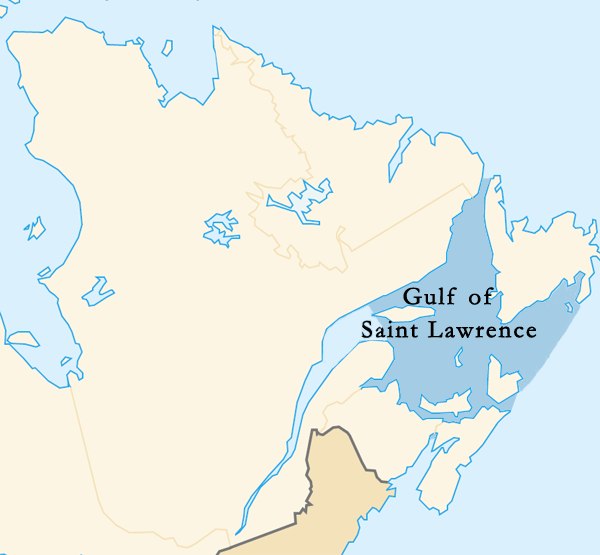
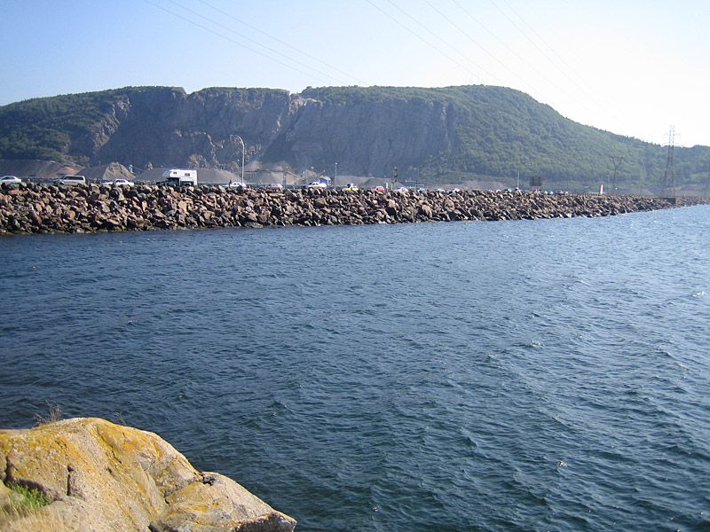
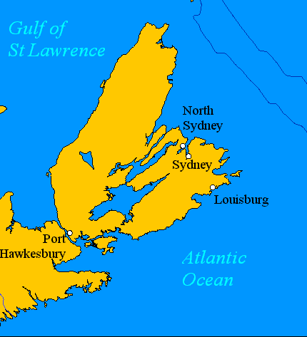
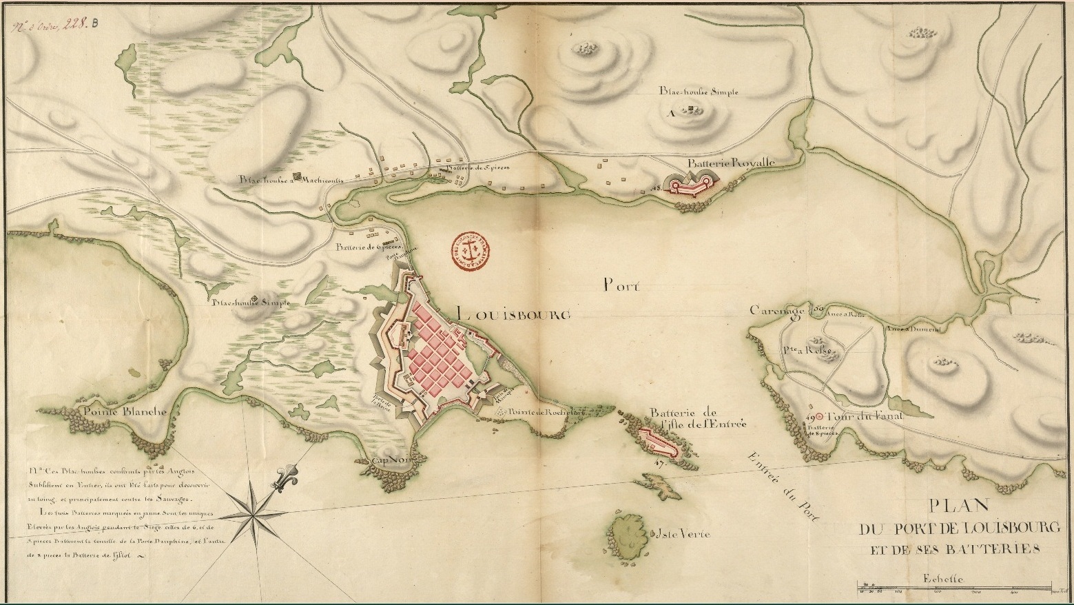
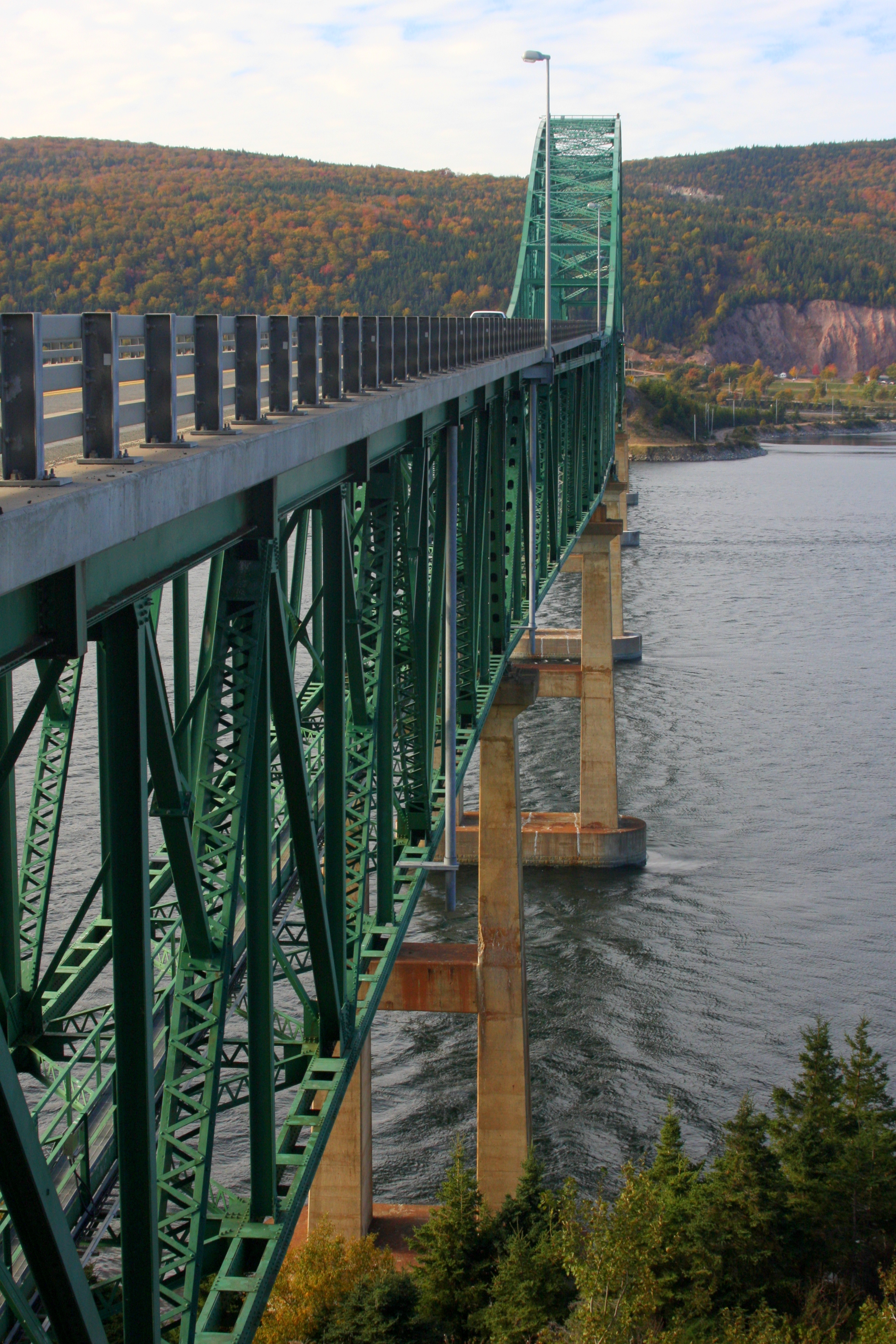
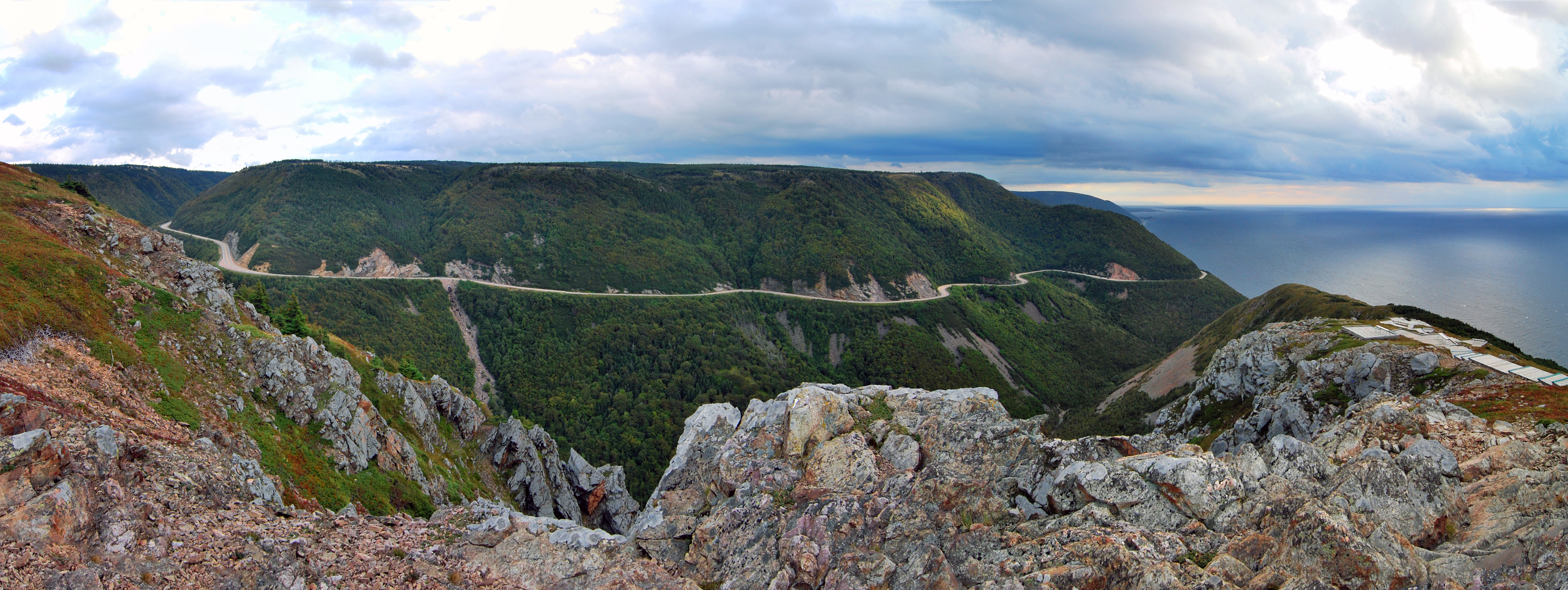
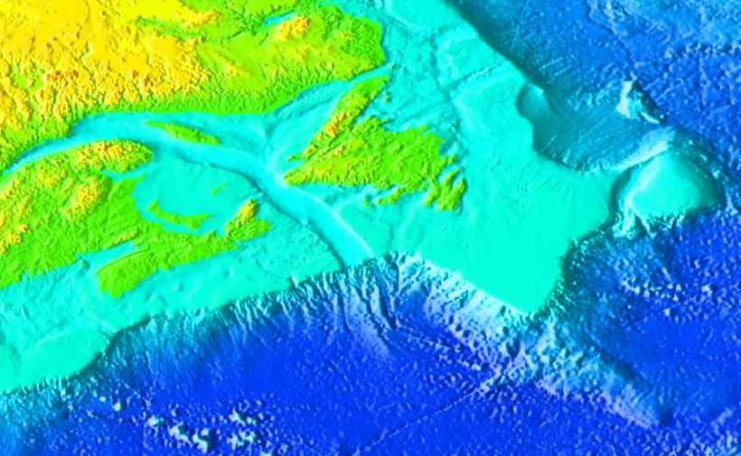
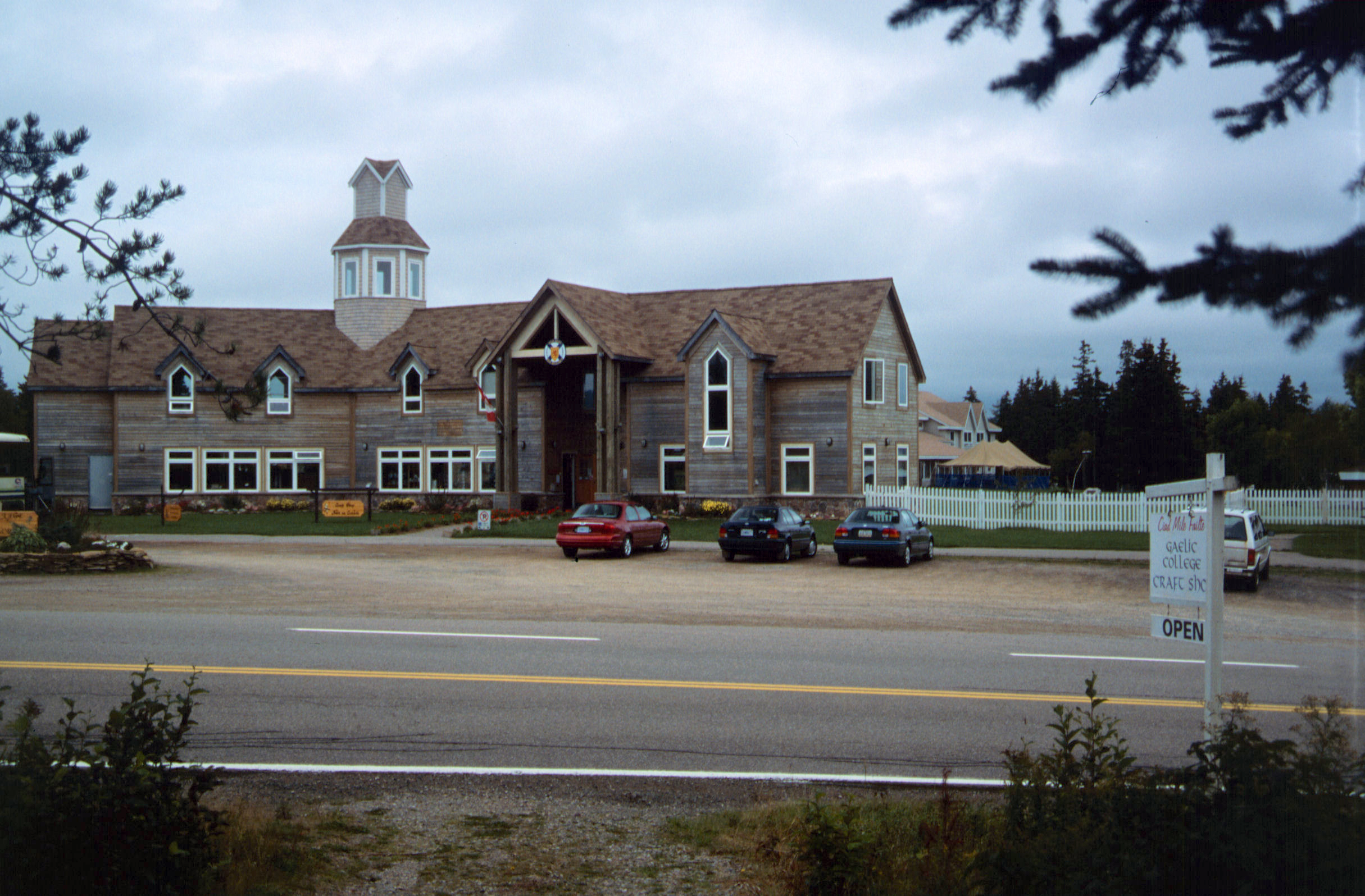
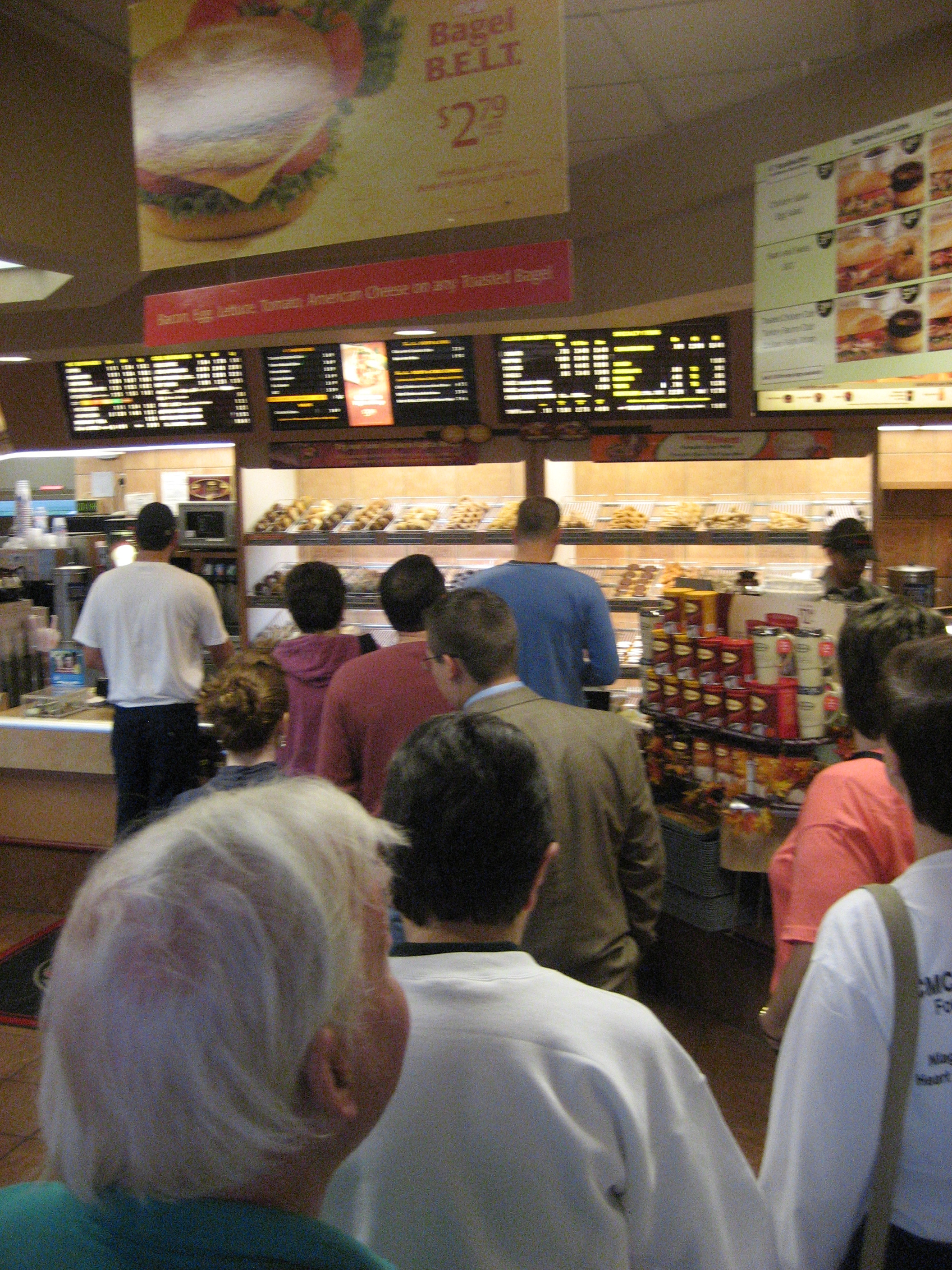