|
Reflections 2015
Series 16
August 29
Ecuador III: Train II–Chimborazo–Humboldt–La Ciénega–Cotopaxi-F.E. Church
| | Since we're still on the train for two more days out of the four, let's present our two rail maps again:
http://upload.wikimedia.org/wikipedia/commons/thumb/2/2e/Railways_in_Ecuador.svg/1000px-Railways_in_Ecuador.svg.png
http://ecuadoroverseasservices.files.wordpress.com/2014/02/ecuador-scenic-train-ride-e28093-tour-at-tren-crucero-guayaquil-quito-2014-02-20-13-22-16.jpeg
| | | | Urbina & Chimborazo We'd spent the night high in the mountains at Hostería La Andaluza at 3,287 m (10,783 ft), which was to be our highest overnight of the entire trip, and now have to backtrack downhill to the south by bus to Riobamba at "only" 2,764 m (9,068 ft) to regain the train. It's Tuesday, Train Day 3, and we start by going north again, relatively close to where we'd just been, to our first destination of the day, the station at Urbina, the highest station in Ecuador at 3,609 m (11,840 ft). I'll summarize these altitudes later.
https://upload.wikimedia.org/wikipedia/commons/8/84/Chimborazo_Urbina_tren_del_hielo.jpg
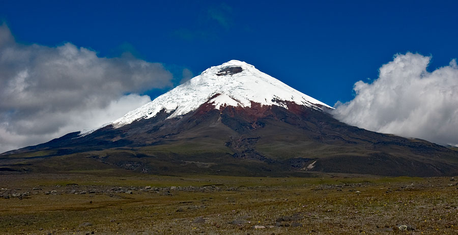
| | | | This view is south, toward back where we just came from, with a railcar on the siding. To the right is the refurbished Urbina Station building, which now has a small museum and gift shop. The poster advertises the regional Tren Ecuador train, the Tren del Hielo (Ice Train), and shows what you'll see, Chimborazo. But of course. Just walk behind the station building to the right to get the west view and you'll have a perfect view of none other than Chimborazo (close rhyme to "lasso") staring you right in the face (Photo by David Torres Costales/@DavoTC). | | | | Again, it's the highest mountain in Ecuador at 6,268 m (20,564 ft), and we had this perfect view, although Adeline told us they hadn't seen it from the train in five weeks! You can never count on mountain views, and we really lucked out. Remember that Aconcagua in the Andes and Everest in the Himalayas are taller, but because of the equatorial bulge, this is the tallest mountain on earth. The variant is sea level. If you measure, as usual, by height above sea level, the others are taller. But local sea level bulges just as the land here does, canceling out any height advantage. If you forget about using sea level as a basis and allow another 21.36 km (13.27 mi) in height, Chimborazo is incredibly higher than Everest. For that matter, add that figure to the height of the Urbina station and we ourselves are higher than Everest as we stand here. | | | | | | The height of Chimborazo as given is the official one. Of course, "official" doesn't always mean totally correct or perfectly truthful. To check this out, I consulted a mountain-climbing website called summitpost.org. It explained that in 1993, members of the School of Military Survey in Newbury UK measured the altitude using GPS and got the above number. The problem—and this explaineth the quandary at hand—is that Chimborazo has five summits. The claim is that the team only reached the second-highest summit, Cumbre [Summit] Veintimilla, and under foggy conditions at that, and got that reading, which is correct for that summit. On a clear day, the highest summit, Cumbre Whymper (you may recognize that name, which we'll discuss below) is visible ONLY from Cumbre Veintimilla, as it's located behind it, and can be reached only by descending and traversing a couple of hundred meters to the east. And the height of Cumbre Whymper is 6,310 m (20,720 ft.), and is the actual highest point. But the "official' one is lower. This picture is from that website and shows the multiple summits beautifully from above:
http://images.summitpost.org/medium/413338.jpg
|
| | | | Last Ice Merchant Chimborazo is currently an inactive volcano. It's last known eruption is believed to have occurred around 550 CE. Its summit is completely covered with glaciers, which are mined by locals for their ice. Which brings us, beyond Urbina's altitude and the mountain view, to the third point of interest here, the Last Ice Merchant. When I'd read about him in the trip description early on, the whole thing sounded incredibly hokey, but it turned out to be really quite interesting. | | | | The best place to start is to point out how modern technology spoils us, in this case with easy refrigeration. It wasn't that long ago that people had ice delivered for their iceboxes. And it goes way beyond that. The Romans would have ice harvested in mountain lakes and brought down to Rome, and before that, it was done in the Middle East, where the ice, properly wrapped in straw, could even be kept in the desert in a protected building for long periods of time. Well into the 20C, ice would be harvested from frozen lakes everywhere (or made artificially) and stored in insulated ice houses, before being delivered for use in iceboxes in the pre-refrigerator period. So it really isn't that odd that workers would harvest ice here. Harvesters would go to Chimborazo glaciers and deliver ice not only locally, but down to the coastal plain. | | | | But of course, it's a dying profession, and today just a novelty. Ice in Spanish is hielo (YÉ.lo), a hielero (ye.LÉ.ro) is an iceman or ice merchant, and these men have been known as Los hieleros del Chimborazo. In the area around Urbina, Baltasar Ushca, below, bills himself as El último hielero, the Last Ice Merchant.
http://www.natgeotraveller.co.uk/wp-content/uploads/2014/01/Attachment-IMG_9845b-620x330.jpg
https://s.yimg.com/ea/img/-/150807/b8841196z.1_20150807120556_000_g9k9qmoj.4_1-1as8c4g.jpg
| | | | It was behind the station on a large lawn that the group met Ushca with his daughter Carmen. These two brought the total of indigenous people I met in Ecuador to three. (Could that be a sort of Panama hat she's wearing?) She was there to assist as he told his story, translated by Adeline, as he demonstrated with a block of ice wrapped in straw. I'm now reporting on what he said, supplemented by online information, of which there's a wealth. It was so odd; behind them was that breathtaking view of Chimborazo, so there was the beauty of the moment, but beyond that, he was talking about hiking right up to Chimborazo to get his ice, which seemed a bit unreal. | | | | He's a very small guy, just 1.5 m (4 ft 11 in) tall, very grizzled, with a weather-beaten face showing years of exposure to wind and sun. He said he started doing this at age 15, and he's now 71. That caught my attention, since I thought he was much older than that. And then I realized, he was four years younger than I was, a fact that didn't go down too well!
http://1.bp.blogspot.com/-2dUh7_PY69k/U26G06YBHOI/AAAAAAAAADU/h00jT7drSqY/s1600/Chimborazo-Foto-Patricio-Teran-COMERCIO_ECMIMA20130511_0164_4.jpg
http://s2.dmcdn.net/3-Fy/x240-O2t.jpg
http://www.c21media.net/wp-content/uploads/2012/08/The+Last+Real+Iceman+of+the+Chimborazo.jpg
http://images.nzz.ch/eos/v2/image/view/643/-/text/inset/71971083/1.18390958/1411653867/chimborazo.jpg
| | | | The first picture shows him leaving with his donkey, which he now does only twice a week, at 7:00 and it's five hours each way, going up to the 4,800 m (15,748 ft) level. The glaciers have receded over the last two decades, so the walk is much longer. In winter it's freezing, and the summer sun increases the chances of avalanches. The second picture shows how, at one point, he stops and cuts the straw he needs to wrap the ice before reaching the part of the glacier that's an "ice mine" at around noon (picture three). He uses a pick to break the ice off the glacier, then breaks it into smaller pieces wraps them in straw, and loads them on the donkey, getting back in the late afternoon (picture four). He can carry two 30 kg (66 lb) blocks of ice on his shoulders. On Saturday he goes to Riobamba's markets to sell the ice for $4 a block.
http://laughingsquid.com/wp-content/uploads/2013/06/the-last-ice-merchant-documentary-about-an-ecuadorian-man-who-harvests-glacier-ice.jpg?w=1200
| | | | He's well known. Dozens of international film crews have followed him. He's flown to New York to attend the premiere of one of the documentaries about him. Locally, people want their picture taken with him at the markets. He's met Ecuador's President Correa and other politicians, who hail his work as part of Ecuador's heritage. | | | | But the story takes an interesting twist. Actually, he's now started making the trip with his son-in-law Juan, who's aware of other business possibilities. Juan takes visitors for an excursion to the ice mine for $60 a day. Contrary to Ushca being the last iceman, Juan is showing interest in this new aspect of the business. He hopes to take over after his father-in-law retires and charge even more for the excursions. The additional financial benefit might help this ancient tradition survive.
https://mamaquieroserturista.files.wordpress.com/2014/08/20140809-hielerom-2.jpg?w=642
| | | | After his talk, they come into the station and stand at this display area. There is ice cream for sale that's been made with his glacial ice. Finally, take a look at this YouTube video (2:21) about El último hielero. | | | | Ambato Back on the train, it wasn't far to Ambato for lunch (see route map). Ambato, like Riobamba, was another city that was larger than I expected.
http://www.hotelrokaplaza.com/photo_content/fullimages/ubicacion1_f.jpg
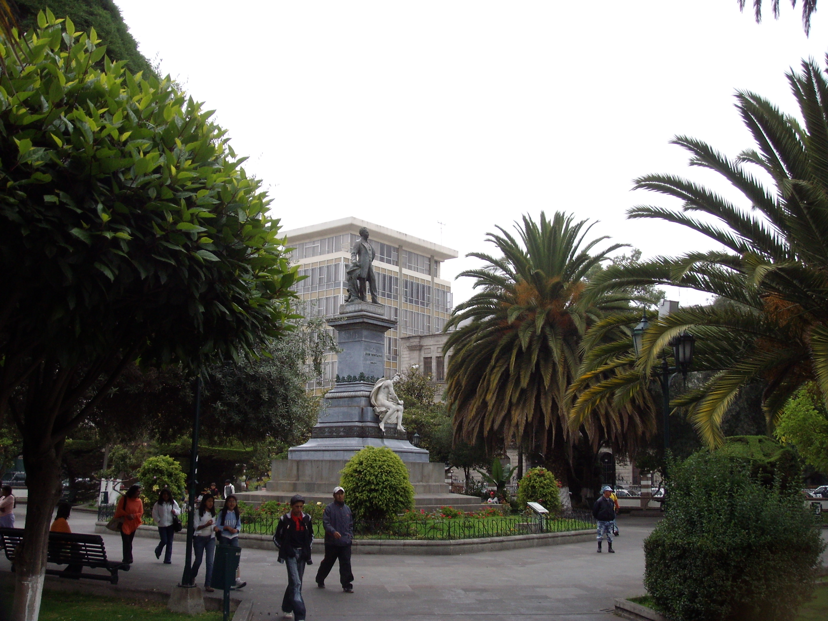
| | | | It was really only a whirlwind passing through, although it was the first time we took an urban walk as a group. I see now, after the fact, that the train station is to the upper right on this map. Our buses brought us down Bolívar and let us off at the large green square in the center, next to the cathedral. | | | | Ambato has always suffered from earthquakes, and a horrific one struck on 5 August 1949, resulting in over 6,000 dead and thousands homeless and destitute. Much of the city's colonial center was completely ruined, including the much-admired cathedral. The city was rebuilt, and in 1954, a very white, very modernist cathedral was built. Enough said. | | | | The group stepped into that green area on the map where we'd been left off, which turned out to be Ambato's main gathering point Montalvo Park (no attribution), built in 1905 and named after an Ambato-born writer, Juan Montalvo, whose statue is in the center. Then the group walk continued a short way down Bolívar to the Roka Plaza Hotel, where we were to have lunch:
http://q-ec.bstatic.com/images/hotel/840x460/408/40807999.jpg
http://media-cdn.tripadvisor.com/media/photo-o/02/cd/8f/33/roka-plaza.jpg
http://reservas.com.ec/images/establecimientos/237-3139.jpg
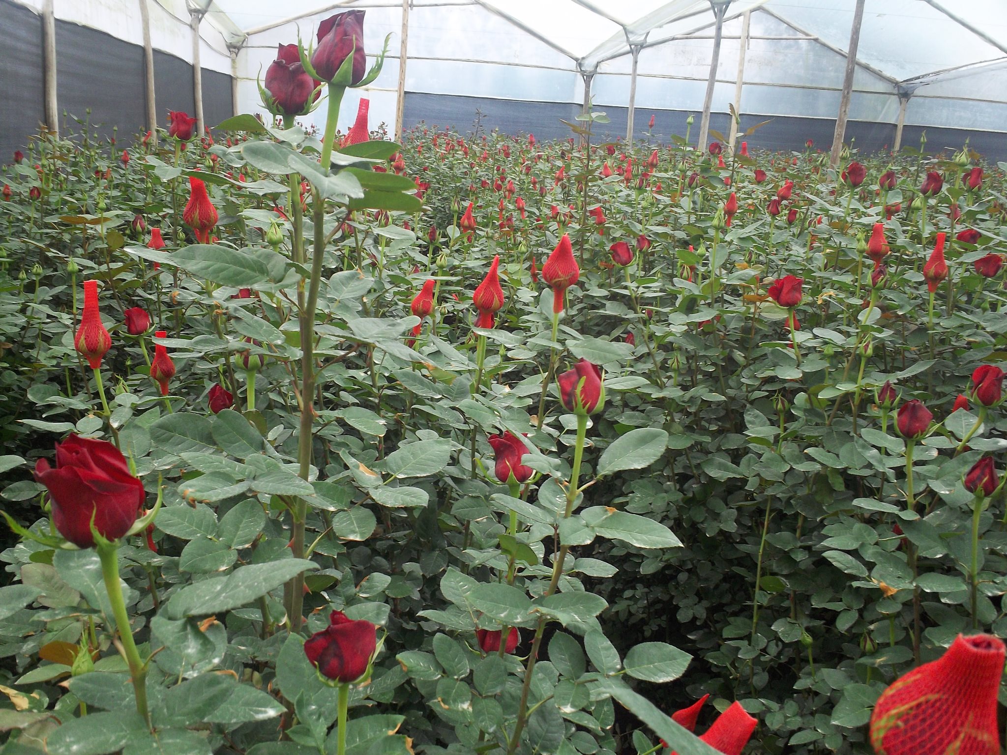
| | | | The first picture shows the handsome stone façade on Bolívar of the Roka Plaza, which calls itself a boutique hotel. We were told it dates from 1936, and survived the 1949 earthquake. In its center is a large stone courtyard where lunch was served. I sat at the lower-left table, upper-right seat. The second picture shows the courtyard view looking back out to the street, where we just came from. The third picture shows the reverse, the courtyard view we saw as we entered for lunch. It was a charming atmosphere for a memorable lunch. | | | | Nevado Rose Plantation Just north of Ambato, but before Latacunga, our last stop of the day (see map), we stopped at a small station called Cunchibamba. Our buses took us just to the west to the Nevado Rose Plantation, named after John Nevado, who owns it with his father. John is a Swedish citizen and spends the European summer in Stockholm and winter in Quito.
| | | | I hadn't realized the extent to which cut flowers today were grown in South America and Africa, and, with the increasing use of air freight, it has become economic to ship them promptly this way to markets in North America, Europe, and beyond. The bus let us off at the visitor center, and we walked into several of the many huge canvas hothouses (Photo by amalavida.tv) that house the growing operation. | | | | From what I learned there (again, Adeline translated) and from their website later, I offer this compilation. They've established themselves this high up in the mountains to maximize the sunlight's luminosity, which makes the roses grow faster and taller (see below). Also, the altitude minimizes the bugs they have to fight. They've been in business since 1965 and claim to focus on ultra-high quality roses. They employ over 750 people, who attend what they claim are millions of rose bushes. They say they send 80,000 roses a day to places like Miami, London, Madrid, Milano, and Hong Kong, but an article I read says they do 80% of their business in Europe, with their largest market being Russia, "which has a very floral culture". | | | | This view show the size of the huge greenhouses we visited (Photo by Myskoxen), with row after row of roses. If you click, you'll see that some have protective nets on them. We also went into the post-harvest room, which controls activity after roses are cut, in the bud, and then need refrigeration. Since they are cut very early in the morning, the first hours of the day are of greatest activity. The display room (Photo by amalavida.tv) showed how they bunch the roses in bunches of 10, 12, 20, or 25, or how a client requests it.
http://iloveroses.com/blog/files/2010/02/John-Nevado3.jpg
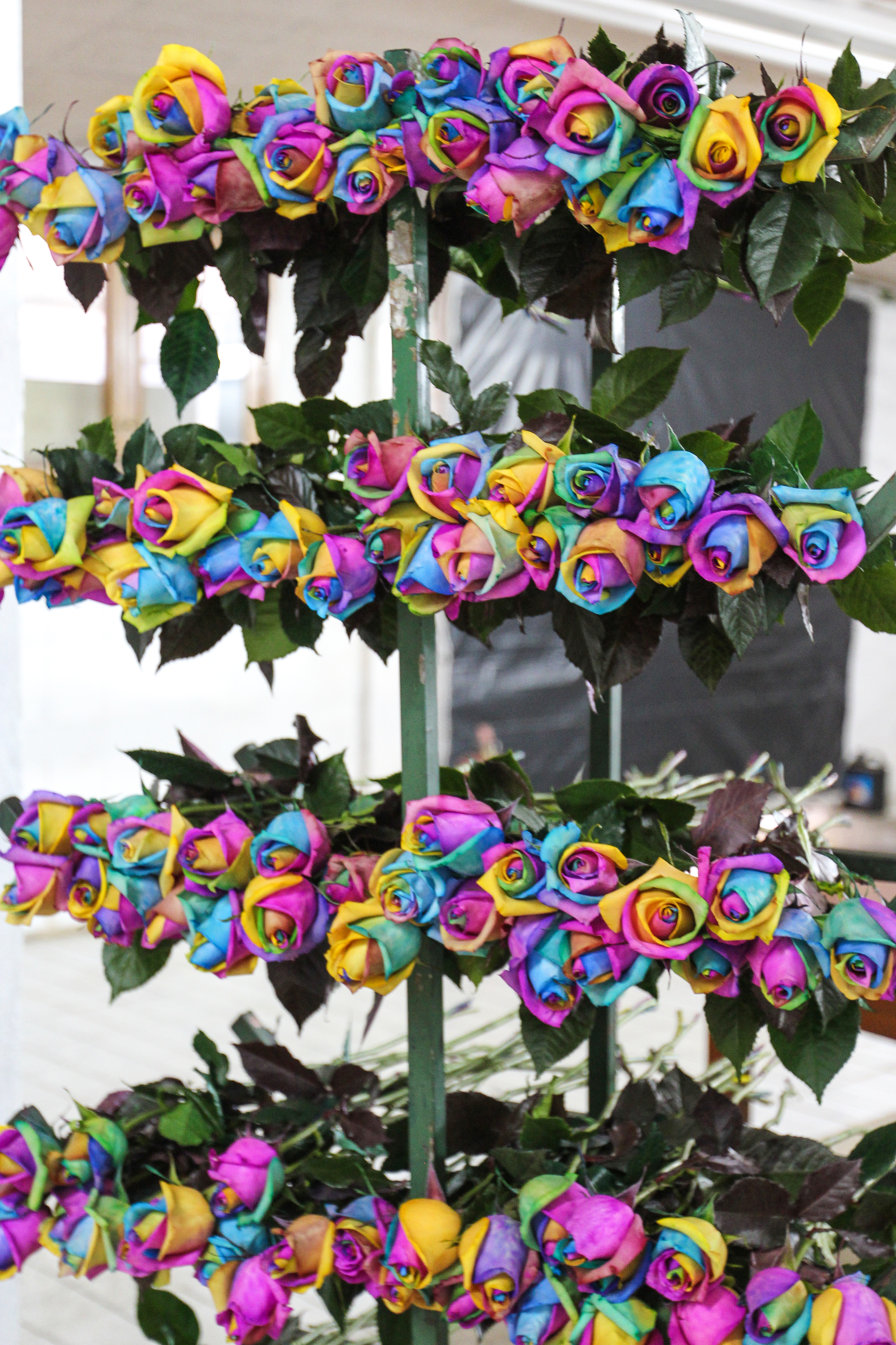
| | | | We also saw some unusual things. We mentioned tall roses above. They classify their roses in sizes from 30-150 cm (roughly 1-6 ft), as this startling picture of John Nevado shows. He calls this their signature "Size Matters" rose. We also saw something I've since read about further, unusually colored roses, which are trendy now in other places, including Amsterdam. The petals of certain roses can be artificially colored using dyed water, such as these blue ones, or these so-called "rainbow roses" (Both photos by amalavida.tv). Bunches of both types were on display. It's done by an uncomplicated process that's been known for over a millennium. The stem is split and each part is dipped into different colors of water, then the rose's natural process of drawing water up into the stem is allowed to take place. However, this shortens the life of the rose. The original rainbow rose with the seven colors of the rainbow is the most popular of this type, but they can be made to order, such as in two Halloween colors or two Christmas colors. | | | | You may like these variations, but personally, I think ultra-long stems are silly—where do you put them?--but they don't bother me. What bothers me is the abomination of coloring nature to one's whim. I'd say that people who are interested in buying these, or in ordering personalized ones, have too much time on their hands and should put their efforts to other purposes. | | | | I enjoyed the rose plantation tour, but it was here that I first felt the toll of the altitude and the pills I was taking for it and for stomach problems ("don't operate heavy machinery"). I'm always up front in a tour group, but I found I was lagging behind as we walked from greenhouse to greenhouse. This was a precursor to my later deciding the next day to start seeking out maté de coca. | | | | Alexander von Humboldt Before we get to our next Hacienda for the night, we need to update information on another historical figure that is involved in this area in addition to La Condamine and the French Geodesic Mission, and that is Alexander von Humboldt of Prussia, who was born and died in Berlin. I'd thought I'd known about him sufficiently, but was surprised to find out the extent to which he was admired, and the extent to which his scientific work was respected. As I now understand it, Humboldt's scientific prestige was to the 19C what Albert Einstein's was to the 20C. We'll only summarize his connection with the Americas. This connection involves his extensive trip to the Americas between 1799 and 1804, particularly Latin America, which he explored and described for the first time from a modern scientific point of view. He published his findings in an large set of volumes over 21 years, and the work was still considered incomplete. One of the points he made was the proposition that, before the Atlantic Ocean existed, the Americas were attached to Europe and Africa, most noticeably when comparing the east coast of South America with the west coast of Africa. This is a painting of Alexander von Humboldt in 1843, which hangs in Schloss Charottenhof in Potsdam. He would then have been about 74.
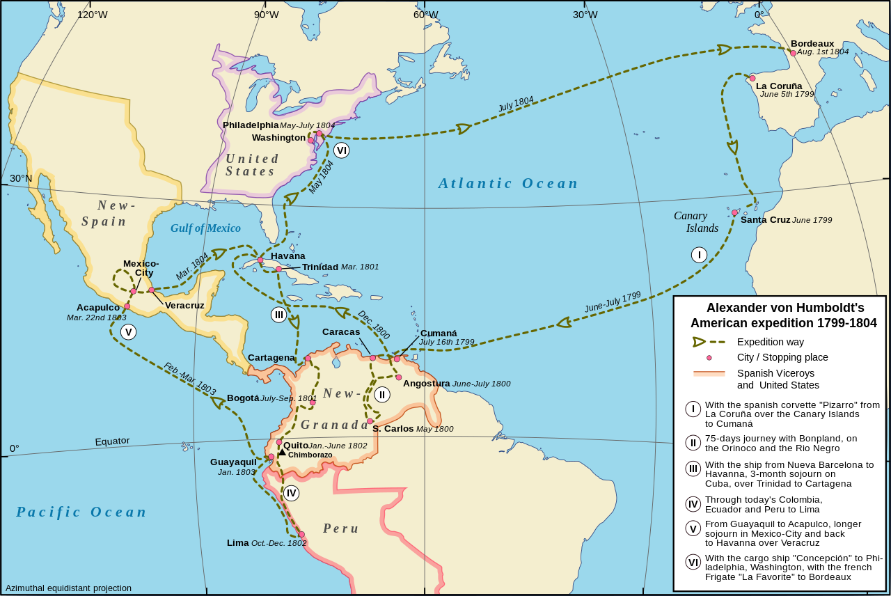
| | | | Humboldt left Paris with botanist and explorer Aimé Bonpland, having found that their plans were in flux. They'd hoped to join Napoleon in Egypt, but that didn't work out. They got as far as Madrid, where the government there offered them unexpected patronage to travel to Spanish America, so that became the goal of their explorations. They sailed on 5 June 1799 from La Coruña, and this map shows the route of their five-year American expedition of 1799-1804 (Map by Alexander Karnstedt). In the expectation you may want to follow more closely in another window, here's the direct link to the same map:
https://upload.wikimedia.org/wikipedia/commons/thumb/a/a0/Map_Alexander_von_Humboldt_expedition-en.svg/1280px-Map_Alexander_von_Humboldt_expedition-en.svg.png
| | | | You will note that all their stops but the last were within the Spanish Empire. His first stop was in the Canary Islands, for six days in Tenerife, where, believe it or not, he climbed Teide (almost rhymes with mayday). See 2012/10 when I drove from the coast up the Orotava Valley back towards Teide. This is where Humboldt famously viewed the Orotava Valley in 1799, and looked across it to see Teide, which he then climbed. | | | | He and Bonpland then stopped in South America, where, near Caracas, he climbed a mountain with another climber. He then explored the Orinoco River for four months, and continued on to Cuba for several months. Coming back to South America and heading for Quito, he took an unusual route. On this entire trip to both sides of Latin America, he never crossed at Panama. Instead he landed at Cartagena, Columbia, and suffered a long and tedious journey up the Magdalena River and across mountains to finally reach Quito—from the north—on 6 January 1802. They climbed a volcano to the west of Quito, Pichincha, that we'll discuss later. They stayed in the area until June becoming involved in numerous studies on numerous topics, including volcanism. South of Quito is the active volcano Cotopaxi, which is the second highest summit in Ecuador, at a height of 5,897 m (19,347 ft). Humboldt was the first European who tried to climb Cotopaxi, but he only reached a height of about 4500 m (14,765 ft). However, he did witness an eruption of Cotopaxi, but only by ear; that is, audibly, but not visibly. | | | | Part of the time they moved south of Quito, where they stayed in the Hacienda La Ciénega, which is near both Chimborazo and Cotopaxi. Their goal was an attempt to climb to the top of Chimborazo. They didn't make it all the way. They reached an impassable crevice 400-800 meters/yards from the top, and were also overtaken by altitude sickness—quite worse than mine—that included dizziness, nausea, and bleeding gums. In addition, their feat is remarkable considering the total inadequacy of their shoes, clothing, and equipment. But they did reach an altitude of 5,878 m (19,286 ft), which set a world record at the time which lasted almost three decades. Since the official height of Chimborazo is 6,268 m (20,564 ft), Humboldt climbed 94% of the way to the top. In 1802, Humboldt was 33. | | | | | | I think it's reasonable to believe that Chimborazo was a major reason Humboldt came to the area, even though he had many other activities there, since it should be pointed out that until the beginning of the 19C, it was thought that Chimborazo was the highest mountain on earth, even measuring from sea level, so it drew many to attempt to climb it. Humboldt even noted on a document we'll see below that La Condamine tried in 1738, but didn't reach what Humboldt did. In 1831 two climbers reached a new "highest point" of 6,006 m (19,705 ft). Then it was the turn of the English mountaineer Edward Whymper. He's best known for the first ascent of the Matterhorn in 1865 and first ascents of the Mont Blanc massif and others. In 1880, Whymper and two others were the first to reach the summit of Chimborazo. However, there were many critics who doubted he'd made it, so later that very same year, he did it again on a different route, with two other climbers. It is understandable that the true summit of Chimborazo is named Cumbre Whymper. |
| | | | As a reflection of the importance Humboldt's visit to South America was given, this is a painting by Friedrich Georg Weitsch done c 1810 showing Humboldt and Bonpland at the Foot of Chimborazo to illustrate it. Compared to photos we've seen, Chimborazo in the painting looks rather pointy. But on the other hand, this is a watercolor of Chimborazo, again looking very pointy, "based on the notes of Alexander von Humboldt", and published in 1810 along with other writings. Though I found no accreditation for the art work, what I've read suggests it's the work of Bonpland. | | | | When Humboldt left this area, he continued overland further south heading toward Lima. But on the way, they did a side expedition, not shown on the map, to investigate the source of the Amazon River. In 2011/13, at the time of the Amazon cruise, we mentioned this: In Peru, what is considered the headwater of the Amazon comes down the Apurimac, Ene, and Tambo, which form the Ucayali. 100 km before (south of) Iquitos, the Ucayali joins the Marañón, and here the river is for the first time actually called the Amazonas.Well, it was Humboldt and Bonpland who researched the Marañón on this side trip in 1802. And again, there's an oil painting of Humboldt and Bonpland in the Amazonian Rainforest by one Eduard Ender from c 1850, located in the Berlin-Brandenburgische Akademie der Wissenschaften (Berlin-Brandenburg Academy of Sciences). After that, they went on to Lima. | | | | After a stop in Guayaquil, they went to Mexico, where they spent a full year in Mexico City. When they left, there was another stop in Cuba, and then they made their only stop in the Americas that wasn't Spanish when they visited the United States. Because of Humboldt's extensive travel correspondence, he was already highly respected there as a researcher and scientist. He stayed at the White House as a guest of President Thomas Jefferson, who himself was a scientist and where they had numerous intense discussions on scientific matters. His six week stay also included a stop in Philadelphia, from where he sailed down the Delaware to return to Bordeaux on 3 August 1804. | | | | This summary is meant to show his trip to the Americas, particularly to the Quito-Chimborazo-Cotopaxi area, and does not even attempt to list his achievements. But from what I've gleaned as to the results of his trip to the Americas, I've found this: ● His work on botanical geography laid the foundation for the field of biogeography, which is the branch of biology that deals with the geographic distribution of plants and animals (see below); ● he was the first to investigate the rate of decrease of temperature with the increase in elevation; ● he discovered the decrease in intensity of the Earth's magnetic field from the poles to the equator; ● his work in geology mainly involved his study of volcanoes in Ecuador north and south of Chimborazo, including Cotopaxi, pointing out how they appear in a line, based on subterranean fissures; ● as for the origin of rocks, it was previously held that rocks had an aqueous formation, that is, that they were formed by the crystallization of minerals in ancient oceans; he demonstrated the igneous origin of rocks, that is, that they came from magma or lava. | | | | | | The ocean theory was called neptunism, after Neptune, the god of the sea, and the lava theory was plutonism, after Pluto, the god of the underworld. Many eminent individuals were neptunists, notably Johann Wolfgang von Goethe. I have read (though I haven't seen it) that in Act IV of Faust there is a dialog between a neptunist and a plutonist, the plutonist being Mephistopheles himself (Of course! That little devil was promoting his turf!). Goethe, though, implicitly sided with the neptunist side here (and explicitly elsewhere). However, Goethe changed his opinion to plutonism once he read the reports of Humboldt's volcanic studies and recognized their progressive nature. |
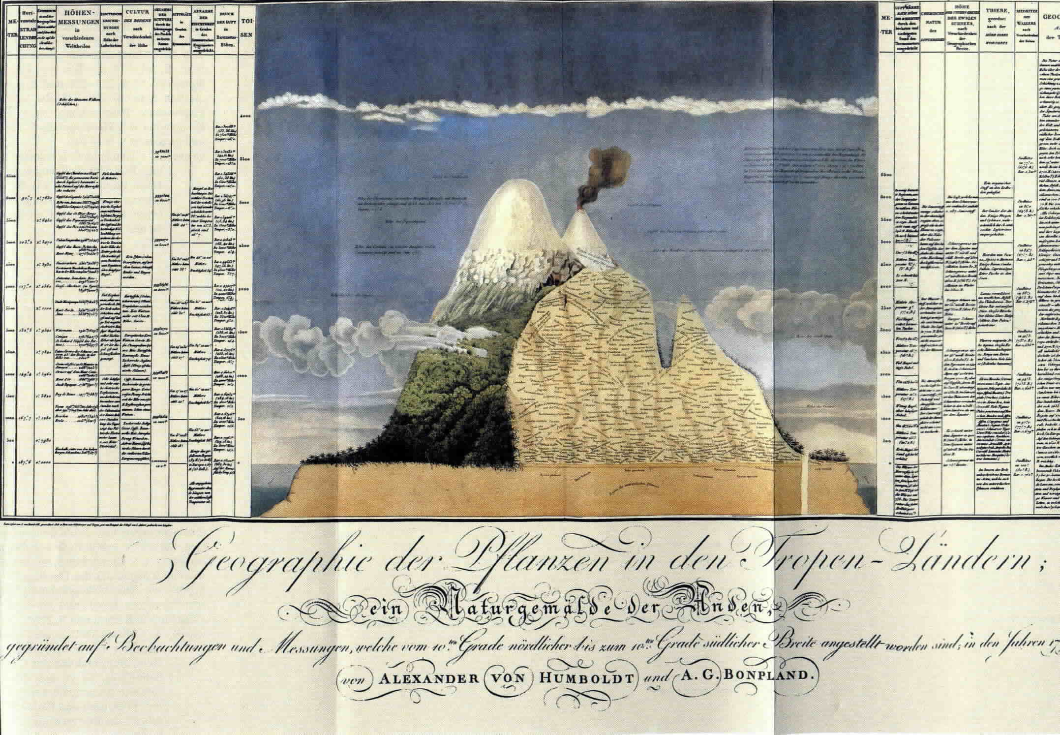
| | | | After their trip, Humboldt and Bonpland published their writings, and among those that apply to our area of discussion is this 1807 document, very illustrative of the work he did here and showing the volume of research they did. This copy is kept in the Zentralbibliothek Zürich, the Zurich Central Library. It's designed by Humboldt, and the artist is Bonpland, which is why I assumed above he was the artist as well. | | | | | | The above version includes a lot of data and clicking expands the view of the German text. However, it might not download well on some computers. If it doesn't, try this version. It's the same document, but doesn't expand as much when clicked. |
| | | | The text at the bottom reads:
Geographie der Pflanzen in den Tropen-Ländern / ein Naturgemälde der Anden / gegründet auf Beobachtungen und Messungen, welche vom 10ten Grade nördlicher bis zum 10ten Grade südlicher Breite angestellt worden sind, in den Jahren 1799 bis 1803 / Alexander von Humboldt und A. G. Bonpland
Geography of Plants in Tropical Countries / a Nature Portrait of the Andes / based on Observations and Measurements made from 10 Degrees North to 10 Degrees South Latitude in the Years 1799 to 1803 / Alexander von Humboldt and A. G. Bonpland
| | | | The incredible number of names written on the picture are all plant names, showing the altitude where they can be found. The only entry I can make out is the very top one, the Region der Lichenen, or Region of the Lichens. The lists on both sides are measurements and names, all dealing with elevations. If you wish to skim, look at these: ● left column 4 lists mountains from around the world, and how they compare to Chimborazo. For example, find Ätna (Etna); ● left 6 is a lot like a modern chart we saw recently which lists the levels that different crops can be grown or animals raised; look for llamas (Lamas), apples (Äpfel), coffee (here spelled Caffe), sugar cane (Zuckerrohr), cacao; ● right column 2 lists temperatures at different elevations; ● right 5 lists animals at different elevations—identify what you can; ● right 6 shows the boiling point of water at different elevations. | | | | There is additional information in the blue sky. To the left is marked the ● Chimborazo summit; ● Höhe des Chimborazo, zu welcher Bonpland, Montúfar und Humboldt mit Instrumenten gelangt sind, d. 23 Jun. 1802 . . . / Height of Chimborazo reached by Bonpland, Montúfar, and Humboldt with their instruments on 23 June 1802 . . . ; ● height of Popocatépetl; ● Höhe des Corazón, zu welcher Bouguet und La Condamine gelangt sind im Jahr 1738 / height of Corazón [presumably a foothill] reached by Bouguet and La Condamine in 1738 (up until I saw this notation, I had no idea the French Mission hat tried to climb the mountain); ● height of Teide (which he spells Teyde, and had just climbed in Tenerife). To the right, among other things, he shows the height of Mont Blanc, the City of Quito, and Vesuvius. | | | | Humboldt Accolades Humboldt has been honored in many ways. Bordering western South America to begin with is the Humboldt Current which flows toward the Galápagos. In 2015/11 we talked about the species of tropical penguins, including the Humboldt penguin, Spheniscus humboldti, which lives in Peru and Chile. I've seen a list of 11 other plant and animal species named after him. | | | | There are many places named after Humboldt. When I was in Eureka, California (2008/19), the town was located on Humboldt Bay in Humboldt County and I'd just visited Humboldt Redwoods State Park. There are glaciers, mountains, and rivers named after him worldwide. Eight US states, plus Saskatchewan in Canada, have towns named Humboldt, and Nevada and Iowa also each have a Humboldt County. Several schools and universities are named after him, most obviously the prestigious Humboldt-Universität zu Berlin, founded in 1810 by Alexander's older brother, the educational reformer and linguist Wilhelm von Humboldt, which was renamed in 1949 to honor both brothers. | | | | Note the following:
Charles Darwin, whose voyage to this region took place around three decades after Humboldt's, made frequent references to Humboldt's work in his Voyage of the Beagle, expressing his debt to him and admiration for his work. He called Humboldt the "greatest scientific traveler who ever lived".
Simón Bolívar said that ""The real discoverer of South America was Humboldt, since his work was more useful for our people than the work of all conquerors."
Edgar Allan Poe dedicated his last major work to Humboldt.
Johann Wolfgang von Goethe said that "Humboldt showers us with true treasures".
Friedrich von Schiller noted that "Alexander impresses many".
Thomas Jefferson said that "I consider him the most important scientist whom I have met".
| | | | La Ciénega After the rose plantation, we went back to the train and went up to Latacunga (see route and tourist maps). We then took the bus up to the small town of Lasso; I now see it's further north along the line, which meant again we'd be backtracking to Latacunga in the morning, but being at the hacienda was worth it. Near Lasso we pulled into the estate surrounding Hacienda La Ciénega. As outstanding as La Andaluza more, this even outshone that—but just by a little. As the former evoked a wooden chalet, this evoked a stone castle. I was very interested when I noted, on the map of Ecuador I'd purchased before the trip, that this was the only hacienda that was listed on the map as its own destination, such was its historic significance. | | | | While last night at La Andaluza we were at 3,287 m (10,783 ft), at La Ciénega we were somewhat lower at 2,980 m (9,776 ft), making it the second highest overnight elevation of the trip, but still above Quito the next night, which would be at 2,824 m (9,267 ft). Actually, the only higher place I've ever stayed was in Lhasa, Tibet, so these three in the Andes now take 2nd, 3rd, and 4th place.
http://www.grandpoohbah.net/Grandpoohbah/images/Ecuador/LaCienega.jpg
| | | | It had an approach like no other. Our bus pulled slowly down this allée of trees to the hacienda at the end, giving the feeling that the building was lurking out in the woods. From their website I found that the extensive estate is rather boggy, caused from water coming down from the Chimborazo glaciers, which were not that too far distant, but again, there was no time to go looking for distant views. But the bogginess they mentioned explained the name La Ciénega, or, The Marsh, which reminds me of the famous La Cienega Boulevard in Los Angeles.
http://www.ecuadorboutiquehotels.com/uploads/94/77/9477324960b7851b27c63546dc844e11/hosteria-la-cienega-content.jpg
http://cdni.adventure-life.com/2013/11/14/fullsize/yw4zjc97.jpg
| | | | The allée widened at the end to a circular arrival area, around a fountain, as in the first picture. The bus then let us down in front of the venerable stone manor house, the Hacienda La Ciénega. It was an aristocratic arrival. No, it wasn't like guests arriving at Downton Abbey, but that's the sort of sugar plum that could dance in one's head. | | | | The building was one massive square, built around a large, open courtyard in the center with another fountain in the middle. The hallways went around the courtyard on all sides, with large windows always facing the courtyard side.
http://images.travelnow.com/hotels/6000000/5950000/5946700/5946606/5946606_31_b.jpg
http://media-cdn.tripadvisor.com/media/photo-s/06/c3/d4/44/accueil.jpg
| | | | The main entrance brought us into the arched lobby that demonstrated the massiveness of the building. The reception desk was to the right, visible in both pictures, and both pictures also show that the reception area ended at the central courtyard. But in the second picture, you can just barely see archways where you could turn left or right to go down the hallways surrounding the courtyard. Note the bells, which we'll discuss below. The website claims the building has walls two meters/yards thick, which has helped it survive many earthquakes. I could believe that from the second picture, but what I found more of were hugely impressive walls just one meter/yard thick.
http://trekhound.com/wp-content/uploads/2010/02/Cienega2.JPG
| | | | Once I dropped off my bag, I took a tour of the building and courtyard, as the late afternoon was ticking by. I found a little church off the right-hand corridor that was built right into the building, and dated to 1586, and was therefore the oldest part of the structure. Otherwise, the estate on which the hacienda was built was bought by landowner Don Matheo de la Escalera y Velasco in 1695. I can only assume the hacienda was then built to include the church. It’s the bells dating from 1764 from this church that are on display in the lobby. The church, as well as some other areas of the building, are decorated with art works of the Escuela Quiteña / Quito School. It was in 1981 that the hacienda was converted into anhostería / country inn. | | | | I went out into the central courtyard to get the perspective from the middle of things. This revolving panorama from Ecuador 360 will give a feeling of being there. Note at the beginning how the church faces the courtyard as well.
http://www.eugeneparnell.com/photos/ecuador/IMG_0184.jpg
http://media-cdn.tripadvisor.com/media/photo-s/07/39/03/6a/hacienda-la-cienega.jpg
| | | | Some of the halls surrounding the courtyard were wide enough to also serve as lounges, as both pictures show. My corridor to the left of the courtyard looked something like this, with two steps up into the room. The thing that gripped me the moment I first entered my room, which was quite large, to drop off my bag was that, not only was there a fireplace, but a fire had been set in preparation of our arrival. I did sit at the fire for a bit later to enjoy it, but could have used a lot more time there.
http://media-cdn.tripadvisor.com/media/photo-s/07/9d/ae/5e/hacienda-la-cienega.jpg
http://trekhound.com/wp-content/uploads/2010/02/Cienega6.JPG
| | | | This room is not quite like mine, which certainly didn't have three beds, and you can't see if it has a fireplace, but I show this picture for two reasons. My room had a windowsill that was indeed one meter/yard deep, and you can see that in this room, where the thickness of the wall is wider than the open shutter. Also, note the standing space heater. For when the fire dies down, I had two space heaters like this and an electric blanket. After dinner, with a dying fire, I did use one space heater overnight. We are REALLY up in the mountains here, and it was cool. The second picture shows the dining area. | | | | It was a very enjoyable venue to spend the night, but I have not yet told the whole story. As a matter of fact, I've been a bit devious, but I must say, I have given out the answer already, obscured by other data. In our extensive discussion of Alexander von Humboldt, when we said that so much of his activity studying volcanoes, animals, and plants, and then climbing Chimborazo and Cotopaxi, I did say where he and his party was living near these areas over that period of time, and I did say it was at the Hacienda La Ciénega. I was aware of that fact from the minute we arrived there, and I found it a very enjoyable contemplating the thought.
http://www.clave.com.ec/frontEnd/images/objetos/_MG_8440_20130515121436.jpg
http://www.ibike.org/ibike/ecuador/images/2012a2a/IMG_2276.JPG
| | | | However, now, long after the fact, I'm kicking myself for not asking for a tour, or at least for information on Humboldt. After searching Spanish and German online articles, I recently found out that, on the third floor, there's a Von Humboldt Suite (first picture) with a curved ceiling finished in pumice rock. I do not know if this is the room he actually stayed in, or if it's just named in his honor. As for this bust, a German text says it's outside the room (so I maybe could have seen it if I'd known it was there), and a Spanish text says it was donated by "a president of Germany". You can see it's his name on the bust, but I wanted to vicariously enjoy the plaque inscription, on the basis of my motto to never let a historical marker pass you by. I was able to blow up a copy of this picture on my computer and read that after his name, the plaque says simply "VIVIÓ EN [lived in] LA CIÉNEGA, LATACUNGA / EN EL AÑO 1802". It doesn't confirm anything I didn't know, but: mission accomplished. | | | | Before we discuss the other international names that stayed here, I'll say that I found on their website that the independence leader Antonio José de Sucre (SU.kré) stayed here—the capital of Bolivia is Sucre, in his honor. I counted the names of six presidents of Ecuador who stayed here. In the Galápagos in 2015/10 I said "An early 20C president of Ecuador was General Leónidas Plaza, whose name appears in South Plaza (also North Plaza). Juan José Flores was the first president of Ecuador in the early 19C and his name appears in Floreana. Well, among those six that stayed here, Leónidas Plaza was one of them. So was Juan José Flores, who was the very first president of Ecuador. Furthermore, I'm informed that Flores signed in this building the Tratado de [Treaty of] La Ciénega. I would love to know what that treaty was all about, but I haven't been able to find a word about it, in any language. | | | | But I was also keenly aware when I was there of the other international guests besides Humboldt that stayed there, and just sixty years before him. Six years after the French Geodesic Mission arrived in Ecuador in 1736, Charles Marie de la Condamine and the others arrived to stay at La Ciénega in 1742 to study the volcanoes. Like Humboldt did later, La Condamine had also climbed Pichincha in Quito, and he then observed an eruption of Cotopaxi, near La Ciénega. Then, as we noticed, he also attempted to climb Chimborazo. La Condamine's stay developed into a long, meaningful friendship between him and the owner of the hacienda, the Marquis de Maenza. My knowledge of this was intensified at the moment of our arrival. As people were getting off the bus, I noticed this shoulder-high historical marker outside facing the entrance. I went over to read it (you know my motto), and it was mostly in Spanish, with three lines in French. I tried telling others about it, but to no great interest. In fairness, at the time I didn't have all the information myself on the French Geodesic Mission. I've found an online picture, and again, was able to blow it up so I could again read the text, which appears here below the picture, followed by my translation:
http://media-cdn.tripadvisor.com/media/photo-s/08/8c/cf/2c/mooie-oude-hacienda-veel.jpg
EN ESTE MONUMENTO HISTÓRICO SE ALOJÓ
CHARLES MARIE DE LA CONDAMINE, CON EL PROPÓSITO
DE ESTUDIAR LA ERUPCIÓN DEL COTOPAXI EN EL
MES DE JUNIO DE 1742.
EL MARQUÉS DE MAENZA, DUEÑO DE ESTA HACIENDA,
FUE SU ANFITRIÓN.
UNA AMISTAD FECUNDA NACIÓ DE ESTE ENCUENTRO
QUE TUVO COMO MOTIVO UN IMPORTANTE ACONTECIMIENTO
TELÚRICO.
HOMENAJE DEL GOBIERNO FRANCÉS EN EL 250 AVO
ANIVERSARIO DE LA VENIDA DE LA MISIÓN DE LA
ACADEMÍA DE CIENCIAS DE PARÍS AL ECUADOR.
HOMMAGE DU GOUVERNEMENT FRANÇAIS AU 250 ÈME
ANNIVERSAIRE DE LA VENUE DE LA MISSION DE
L'ACADEMIE DE SCIENCES DE PARIS EN EQUATEUR.
IN THIS HISTORIC MONUMENT [the hacienda] THERE LODGED CHARLES MARIE DE LA CONDAMINE, WITH THE PURPOSE OF STUDYING THE ERUPTION OF [the volcano] COTOPAXI IN THE MONTH OF JUNE, 1742. THE MARQUIS DE MAENZA, OWNER OF THIS HACIENDA, WAS HIS HOST. A DEEP FRIENDSHIP WAS BORN OF THIS ENCOUNTER, WHOSE PURPOSE WAS AN IMPORTANT SEISMIC EVENT. [Then, three lines, first in Spanish, followed by their translation into French:] HOMAGE OF THE FRENCH GOVERNMENT ON THE 250TH ANNIVERSARY OF THE COMING OF THE MISSION OF THE ACADEMY OF SCIENCES OF PARIS TO ECUADOR. [Based on 1736, this would have been 1986.]
| | | | | | I suspect it remains unclear how all these notables suddenly show up as house guests in private homes. I think the best illustration of what I understand happened would be given within the parameters of the fictional, but very historically accurate, Downtown Abbey television series. There are several instances within that story of guests, sometimes relatives but also non-relatives possibly sent by mutual friends, showing up to stay, not for just a weekend, but for weeks on end, if not months. It seems it was accepted and common practice, particularly among the wealthy and notable, to do this. That would be the basis for Bolívar to have stayed at La Andaluza—surely in the Hacienda and not in the inn—and for La Condamine and Humboldt and the others to have stayed at La Ciénega. Of course, in all those cases, the guests were notable enough that it would have been a plum for those hosts to have had them, but I'm sure it happened with non-notables as well.
This brings to mind the basis behind a common expression, which I've discussed before (2008/4) but bears repeating. In English, when you reject someone, you "give them the cold shoulder." Historically it has little to do with a person's shoulder somehow offered as a rebuff; if it did, the shoulder wouldn't be cold, the rebuff would. It was based more substantially on the custom in past centuries, where, if a guest was overstaying his welcome, long or even short, a host might stop serving hot meals and serve a cold shoulder of mutton instead, considered a poor man's dish. This would be a not-too-subtle clue that it's time to move on.
|
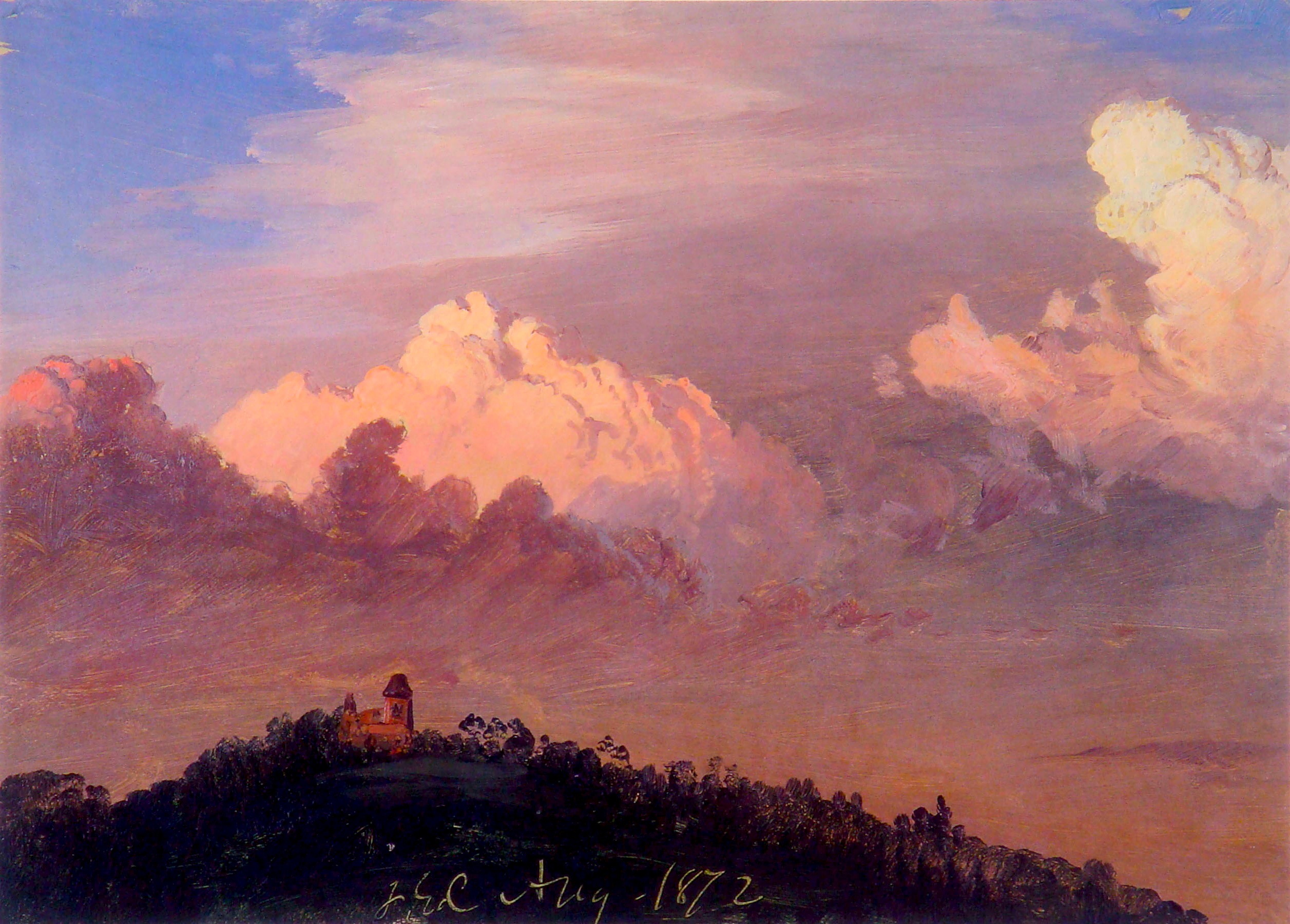
| | | | The next morning it was back to Latacunga station headed toward Quito. It was Wednesday, Train Day 4, which was actually ¾ of a day, followed by ¼ day that served as a short Quito Day 1. There was only one stop scheduled en route, which was at Cotopaxi National Park. | | | | But while I had had a good night's sleep, I still got up feeling even more lethargic than usual, as I'd noticed first at the rose plantation the day before. I did have some breakfast, but was not particularly hungry. I know it was the altitude finally really getting to me, plus those "don't operate machinery" pills to avoid stomach trouble. I weighed my options. | | | | Fortunately, what was planned appealed to me least of all the things we had done. The buses were to go to Cotopaxi National Park, which was quite close, and there was to be a hike through the woods to see Cotopaxi. Even under normal circumstances I don't like long hikes in the woods, although it would have been nice to see the Cotopaxi volcano, which is the second highest peak in Ecuador. On the other hand, clouds and haze can easily obscure a mountain, and we'd been so lucky to see Chimborazo. Above that, I'd had online pictures with me, and the two peaks looked surprisingly alike, very conical and pointed. I made my decision, and told Adeline I'd forego the excursion and stay on the train. After a while, she came around, as always, to give the choices for lunch, which they'd have on the way. I had no appetite. But when I heard a choice for a first course soup would be locro de papas, that I'd enjoyed several times already since the Galápagos—and it was native to the highlands were we presently were—I asked her to bring me some back, plus some chocolate cake for dessert. | | | | It was at this point that I asked for some mate de coca for the altitude, which they didn't have, and they instead offered to give me an infusíón de cedrón, or lemon verbena herbal tea (2015/14). It did help a little, although that might have been in my mind—but that's good, too. They got off at one station for the park and hours later got on at one further up the line, so I got an extra train ride with the crew. But the first thing I did when I finished my tea was to go to the brown-couch lounge, lie down, and sleep deeply for two solid hours. At midday I went and asked for more herbal tea at my seat, and in the early afternoon went to the blue-gray couch lounge—just for variety--spread out quite comfortably again, and slept soundly for another hour and a half. At that point, I did feel better, which means I used the time quite productively, while hiking in the woods would have tired me out even more. | | | | At about two-ish they came back at that later station, and Adeline had brought lunch. The crew set my table and brought a full tureen of locro de papas, so I was able to enjoy more than one bowl, and then had my chocolate cake. I couldn't have eaten any more than that. | | | | Since there were no age peers of mine on the train, I still hope I hadn't gotten a reputation as "the old guy". But several came up to report on the excursion. It was a longish walk up to a lake, where they stopped. But then there were those few highly energetic types who still hadn't had enough, and proceeded to walk entirely around the lake. This reminded me of those at La Danesa who avoided the bus ride back from the cacao exhibition. And the weather was clear enough so that they did see Cotopaxi, and one guy—again I forget who—showed me a picture of it on his mobile phone, which was a very nice of him to do. | | | | They say you can see Cotopaxi from La Ciénega, as both La Condamine and Humboldt had, if the day is clear and you're told where to look, neither of which was the case when I was there. There's also a high point in Quito, El Panecillo, where you can see it, since the two places are only 50 km (30 mi) apart, but when I was there, it was overcast. So I suppose I'm just going to have to be satisfied knowing I was very close to Cotopaxi, and enjoy it in pictures. | | | | This was the picture of Cotopaxi (Photo by Gerard Prins) I had with me in my notes at the time. I still think it's strikingly similar to Chimborazo (see picture above). That black circle MIGHT be the crater, and the severe landscape is typical of the high Andes, which you also saw in the Chimborazo picture. But I've since found this consciously "prettier" picture (Photo by David C. S.), where the photographer captured a greener, cultivated field in the foreground, with just the snow-capped summit of Cotopaxi in the background. | | | | Frederic Edwin Church in Ecuador While the train is slowly continuing on to Quito, I need to bring up two topics that I learned about totally after the fact. I knew nothing about either of these while I was there. The first was the substantial relationship with Ecuador that the American artist Frederick Edwin Church of the Hudson River School had, and the extent to which he was following in the steps of Humboldt. | | | | We can generalize a few words about the Hudson River School, a topic we've mentioned frequently in the past, since it's a favorite. It was a mid-19C American art movement that consisted mostly of landscape painters influenced by romanticism. The movement started in the Hudson River Valley, and is named for it, since much of the landscape art depicts the area. The second generation of these artists, which included Frederic Edwin Church, expanded the subject area to include New England, Maritime Canada, the American West (think especially Albert Bierstadt, the German-American artist), and South America (aha!). | | | | It was a period of American expansion, of discovery, exploration, and settlement. Because of the expansion, though, the remaining rugged wilderness was fast disappearing as it was being encroached upon. Hudson River School landscapes typically depicted both aspects in a peaceful, pastoral setting, with people coexisting with nature, with farms coexisting with the remaining wilderness. They also typically show great detail throughout, near and far; they are usually very realistic, yet often idealized. | | | | Church used all these techniques in his large panoramic landscapes, which usually showed the grand scale of nature in a pastoral setting. They often depicted mountains, waterfalls, sunsets, and dramatic natural phenomena he found on his travels, and contrasted them with people and houses, perhaps with a small boat. He included extraordinary natural detail, but also romanticism in his paintings, which inevitably resulted in some idealization of what he depicted. He notably included luminism (a new word for me). Luminism, a Hudson River School innovation, was characterized by the effects of light in the landscapes, often coming from several sources. It usually involved an aerial perspective of the scene, and emphasized tranquility; the water is calm and reflective; the sky is soft and hazy. | | | | He emphasized nature by using low horizontal lines with a lot of sky to show its majesty and to enhance the wilderness. Any people shown (or houses, boats) are miniscule to enhance even further the striking reality of nature. In addition, on a technical level, Church is known for trying to hide his brushstrokes, which lessens his own presence in the work and makes the scene more naturalistic. | | | | Church took two trips to South America, in 1853 and in 1857. To a minor extent, he visited Colombia, particularly its Magdalena River, but by far the bulk of his time was spent in Ecuador, specifically in the mountains of the Quito area. There's a very specific reason for his choice of Ecuador. Church was inspired by Alexander von Humboldt and his visit about a half-century earlier. That's also why he visited the Magdalena River in Columbia. | | | | Humboldt had challenged artists to portray the "physiognomy" of the Andes, in other words, their appearance. He said the art of landscape painting is one of the highest expressions of the love of nature. Church felt Humboldt was his mentor, his icon, and when this challenge appeared in Humboldt's book published in 1852, Church, then 26, jumped at the chance to travel the very next year and study in Humboldt's footsteps. He did this literally, since he stayed in Quito in the same house Humboldt had lived in. Once Church became famous, one of the reasons for his fame was that he'd avoided the standard artist's trip to Europe to train in favor of working in South America. But this was not only because of Humboldt's influence, but because he felt the unusual nature of the destination would gain him notoriety. | | | | There's an additional coincidence that I made this last-minute discovery of Church having worked in Ecuador because in late July, just about a month before this writing, friend Simi, sister Chris, and I went to spend a weekend at the home of friends Audrey and Jane (2012/1) in Catskill NY. That Sunday, three of us, Audrey, Simi, and I, crossed the river back to Hudson NY (where we'd arrived on Amtrak) to visit Olana, Frederic Edwin Church's hilltop mansion, now a NY State Historic Site. That visit now becomes pertinent, so I've collected three pictures in and around Olana to introduce the subject of Church in Ecuador. | | | | In a reflection of his interest in panoramic landscapes, Church had Olana (Photo by Rolf Müller) built on a hilltop with sweeping views. The most spectacular of these views is from the house down to the Hudson (Photo by Matt Jiggins) and over to the Catskill Mountains on the west bank. Click to inspect the river closely. I think it's particularly impressive how this southwest view crosses the south-flowing Hudson in an X. Church painted many views to and from the house. Just as a preview of what we'll see in Ecuador, I'll include just this one done in 1872, called Clouds Over Olana. This picture is located right at the Olana State Historic Site. Note the low horizon, showing a lot of sky; the blend of expansive nature and a person's residence; the overwhelming appearance of that nature on the tiny-looking residence, which is actually a huge mansion. | | | | Church's Ecuador Oeuvre Church created quite a number of works in and about Ecuador and a few in Colombia. I've listed and illustrated here all his oils that I can directly attribute to Ecuador, and my count comes to 13. But to show the breadth of his South American oeuvre, I'll name these others: "Summer in South America", "Scene on the Magdalena", "Tamaca Palms", "View on the Magdalena River", "Morning in the Tropics", "Rainy Season in the Tropics", "Tropical Scenery (South American Landscape), "El Río de Luz (The River of Light").
| | | | I'll list the paintings chronologically. You'll see that Church's naming is repetitive and often requires further identification. If you've been following this posting, you'll recognize all but one location, in Quito, but should recognize the name of that location.
(1) 1855 Cotopaxi [1855 with House] National Museum of American Art, Smithsonian Institution, Washington. It has all the bells and whistles of the Hudson River School and of Church: intensive detail, low horizontal lines leaving a big sky, large volcano versus small house and miniscule people, romanticism, luminism (light on summit, house, tree on lower left).
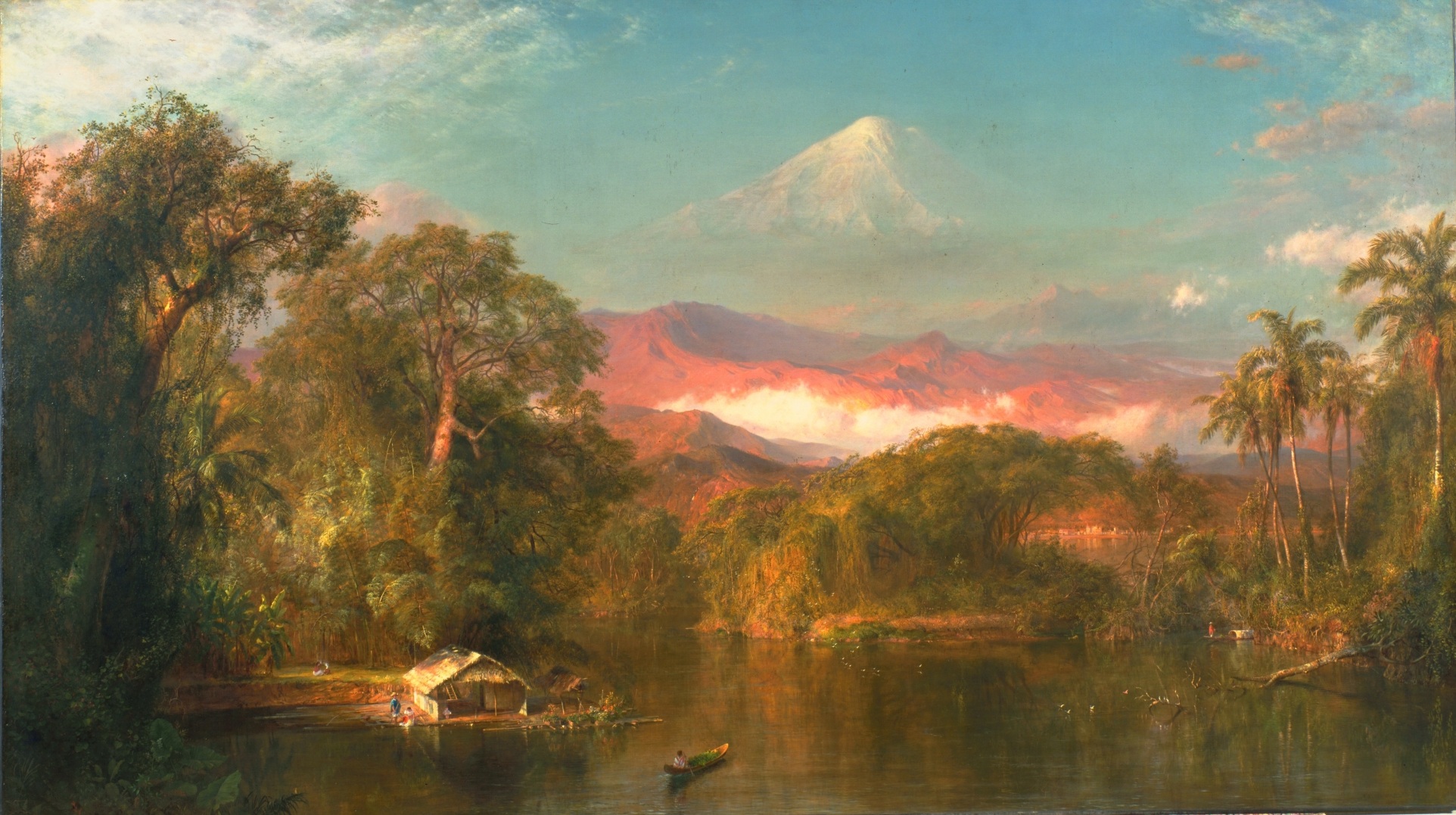
(2) 1855 The Andes of Ecuador Reynolda Museum of American Art, Winston-Salem NC. Similar comments, but with waterfall; striking luminism; high detail; large versus small—note the tiny people; presumably shows Chimborazo, but the scenery there is nothing like this, and there are no palm trees growing naturally this high up in the Andes, so we have romanticism with fantasy.
(3) 1855 Cotopaxi [1855 with Palms] Museum of Fine Arts, Houston. Here the fantasy landscape with palms is even emphasized. Look at the incredible detail.
(4) 1857 View of Cotopaxi [1857] Art Institute of Chicago. Still fantasy, but less gaudy and a little more realistic. Click to see the incredible detail, including the boat and the woman on the lower right. When you expand those, each one could pass for a painting on its own. So could the mountain.
(5) 1859 The painting that fits in here chronologically is "The Heart of the Andes", his masterwork. We'll discuss that separately at the end.
(6) 1862 Cotopaxi [1862] Detroit Institute of Arts. This is one where he depicted a natural phenomenon, an eruption of Cotopaxi. The colors are here wildly vivid, with the ash blocking out the sunset (or sunrise). Yet still, there's a calm pastoral scene in the foreground.
(7) 1864 Chimborazo Huntington Library CA. Note what Church does here with luminism. The center of the picture is filled with light shining on a white and red area, and your eye is drawn right to it. Only then to you notice the almost scary, only slightly lit, Chimborazo hovering above.
(8) 1865 Mount Chimborazo Olana State Historic Site, Hudson NY. As in the last one, the mountain appears only on second thought—it could have been another of the clouds. I saw a lot of his other works when we were at Olana, but I didn't know to look specifically for this one, nor for "Clouds Over Olana" above.
(9) c 1865 Eruption of Cotopaxi Private Collection of Fayez Sarofim. Similar to (6). The garish colors here might be accurate, or it could also be a poor online reproduction.
(10) 1867 Pichincha Philadelphia Museum of Art. Finally, a different mountain! This is the name you might recognize—it's the volcano west of Quito that both La Condamine and Humboldt had climbed successfully. The small figure on the rope bridge in the foreground is a nice touch.
(11) 1867 View of Cotopaxi [1867] Yale University Art Gallery. A less violent eruption.
(12) 1872 Figures in an Ecuadorian Landscape Private Collection. It's unusual that his title refers to the tiny figures, and not to Chimborazo. The greenery, style of stream (this is not glacial runoff!) and bridge are totally romantic fantasy, plucked out of Europe.
(13) 1884 Chimborazo Volcano Yale University Art Gallery. Same comment. Is this some Scottish castle? I don't mean to deprecate his work, since I love most of it, but sometime the fantasy goes too far. We'll now go back to the one we skipped.
(5) 1859 The Heart of the Andes Metropolitan Museum of Art, New York.
| | | | DESCRIPTION This painting is definitely Church's Ecuadorian masterpiece, and probably his best work overall, certainly among his most renowned. It's a large painting, 3 m (9.8 ft) wide and 1.7 m (5.6 ft) high. It depicts an idealized landscape that's a composite of the South American topography he'd observed while traveling, which also explains why there were palm trees in the Andes in other pictures. As usual, despite the perspective, he shows every detail from front to back. This copy expands nicely, so be sure to click to inspect the details. As you contemplate the luminism in the picture, be sure to see the illuminated tree trunk in the lower left where he signed "1859 F E Church" on the bark. | | | | Furthermore, the picture is a visual scientific study of every natural feature that exists in the this area of the Andes. Every species of plant and animal is readily identifiable. As a comprehensive hommage to his mentor, Humboldt, he's distributed flora and fauna properly by altitudinal zones, yet he does so within the parameters of the Hudson River School. In contrast to some brightly colorful scenes in other pictures, such as of sunsets or eruptions, he keeps his palette here relatively restrained, using simple greens, blues, browns, golds, and grayish purples in the mountains. | | | | The eye, captured by the luminism of the waterfall, then follows the valley to the upper left to majestic Chimborazo. As for downplaying the human presence, the path in the foreground leads the eye to some people, but one has to look long and closely before spotting the little village in the center. | | | | RECEPTION In the 19C, it was not unusual for art to be presented to the public in a somewhat theatrical manner. The same year it was painted, 1859, Church showed The Heart of the Andes in New York City in a building specifically designed for artists on West 10th Street. It was shown for 25 days, and attracted an unprecedented turnout for a single painting. 25,000 people paid and admission fee of 25 cents each. Even on the last day, patrons waited on line for hours to enter the exhibit. | | | | There's no photographic record of just how the picture was exhibited, but it is known that Church wanted the room to look like a house, with a window appearing to look out at the Andes. An oversized, window-like frame was used, and curtains were fitted around it. Ecuadorian plants from Church's travels were in the room, patrons were seated on benches, and opera glasses were provided to allow examination of the details, and, given the crowding of the room, might have been necessary to even see the picture at all. The work was an instant sensation, and Church was quickly considered one of the foremost landscape painters in the US. Curiously, 1859 was the same year that Darwin published On the Origin of Species, and so that year, Church was to the world of the humanities what Darwin was to the scientific world. Mark Twain told a friend one would never tire looking at the picture. | | | | With all the positive developments, there was one poignant one. Church wanted Humboldt, his intellectual mentor, to see his masterpiece. Close to the end of the first exhibition, on 9 May, Church wrote that he expected the painting to be on its way to Europe shortly, a main reason being so that it would make its way to Berlin so that Church could have the satisfaction of placing before Humboldt his interpretation of what Humboldt had seen for himself six decades earlier, scenery which Humboldt had pronounced to be the finest in the world. However, Humboldt had died on 6 May, so the painting never made it to Berlin. | | | | But that same year, it did make it to London, where it was just as popular. It then went to six cities in the US, and then had a second exhibit in New York, in 1864 at a location on Union Square. This exhibition is better documented than the original exhibit, since there are photographs of how it was displayed. It still had draperies around it, but the portraits above and handrails were just used at this second exhibition. | | | | Church eventually sold the picture for $10,000, a figure that was at that time the highest price ever paid for a work by a living American artist. But there have been only two owners after Church. It was bought by one Margaret Dows, and, upon her death in 1909, she bequeathed it to the Metropolitan Museum of Art, where it hangs today. | | | | Cotopaxi Erupts! Besides Church, the second thing I was fully unaware of while in Ecuador was that Cotopaxi had started to erupt! So I've now looked into that background. With 86 known eruptions, Cotopaxi is one of Ecuador's most active volcanoes. The first recorded eruption was in 1534, and the most violent eruptions since then occurred in 1742, which would have been the one witnessed by La Condamine, and in 1744, 1768, and 1877. It's reported that these three last ones were on the same huge scale as Eyjafjallajökull in 2010 or Pelée in 1902. Those two eruptions in the 1700s destroyed the colonial town of Latacunga, and the 1877 one sent mudflows over 100 km (62 mi) from Cotopaxi and claimed over 1,000 lives. The one Humboldt heard in 1802 must have been a less violent one. In 1903-1904 there was a major eruption, and there was some minor activity in 1940 and possibly 1942. It has been quiet for almost three-quarters of a century, | | | | Now I hear that in April 2015—I was there in late May--the volcano began to show signs of unrest. There was a large increase in earthquakes. It was put under active watch on 25 June, and began erupting on 15 August. It's been spewing almost constant steam-and-ash plumes up to 5 km (3 mi) into the sky, covering the surrounding area, including Quito. There are fears that the heat could melt the glaciers and flood nearby towns with volcanic mudslides. As of this writing in late August, the Ecuadorean government has declared a state of emergency and has earmarked US$500 million in emergency funding for whenever the big blow comes, since 325,000 people could be affected. A national state of emergency has been declared | | | | If you're interested in developments with Cotopaxi, I suggest you keep checking online. For now, I have a YouTube video (1:43) called Cotopaxi Eruption August 2015. You can compare present events to Church's paintings. | | | | Chimbacalle Station It wasn't all that much further to Quito, but the train didn't move very quickly, so it took a while. The landscape became urban, as we rode through the suburbs, and finally we arrived at Quito's Chimbacalle Station (chim.ba.KA.yé). The station was inaugurated in 1908 by President Eloy Alfaro himself, the man who got the rail project restarted at the end of the 19C. And just as the other terminus is at the Eloy Alfaro Durán Station, we are now in Eloy Alfaro Chimbacalle Station, Chimbacalle being a neighborhood in southern Quito. The station has become an emblematic landmark of Quito and, like all the others, has been extensively restored. | | | | It's no secret that I'm enamored of railroad stations, but what I've read about popular support of Chimbacalle in Quito is really surprising. In 2008, the station was declared Cultural Heritage of Ecuador. In 2010, it was selected as being one of the Seven Wonders of Quito, and in 2011, Quitoans voted it number one among the emblematic marvels of the city. (Even I find those last two points a bit much.) In the past year,160,000 people left by train from Chimbacalle, and 100,000 others just visited the station, which, like some others, features a museum of Ecuadorian trains and a café run by members of the Chimbacalle neighborhood. | | | | I knew enough to be looking forward to seeing Chimbacalle, but I didn't know anything about it. From what I learned on arrival, and have researched since, I'm absolutely delighted about the loop layout that makes for an interesting arrival. That is to say, the station and platform are curved around a track loop that reverses on itself.
https://kanquigua.files.wordpress.com/2014/12/47-mapa-crecimiento-urbano-del-sector-de-chimbacalle-flacso-2002.jpg
https://mts0.googleapis.com/vt?pb=!1m4!1m3!1i16!2i18474!3i32811!2m3!1e0!2sm!3i317000000!3m9!2sen!3sUS!5e18!12m1!1e47!12m3!1e37!2m1!1ssmartmaps!4e0
| | | | Stations curved around loops are very rare, but present a very graceful look. The first map shows how the Chimbacalle neighborhood has grown around the station over the years. But this is the best map I can find to show the loop. The map is turned sideways, and south, where our train came from, is on the left. Note how the track layout allows a train to arrive clockwise around the teardrop loop adjoining the station, whose back is on the northwest side of the loop. The second map, apparently of Google origin, is set up properly. The train arrives from the south at the bottom, and moves clockwise along the curved station, shown in brown. But it also shows there are four other tracks curving the same way, but coming to a dead end. Oddly, this map fails to show how the main track turns back on itself, although the curved street does reflect that.
http://mw2.google.com/mw-panoramio/photos/medium/39968286.jpg
http://www.hotelcasajoaquin.com/web/wp-content/uploads/2015/05/Estaci%C3%B3n-del-tren-en-Chimbacalle-al-sur-de-Quito.jpg
| | | | The first picture here looks south and shows the front of Chimbacalle Station beautifully restored to how it was in 1908. When I was there, the street was full of parked cars, parked angularly, so perhaps there's still construction going on here in this picture. We rise up over roof level in the second picture, still looking south, and see the four stub tracks with parked trains, plus the main track curving gracefully next to the building, then continuing on off the picture. On the upper left corner, we see a bit of the rest of the loop behind the white building. Now it would seem that trains would arrive clockwise from the upper right. However, for reasons I do not know, our train arrived counterclockwise through the upper left before arriving at the station.
http://www.uiomagazine.com/images/chimbacalle/uiomagazine-chimbacalle-009-1000.jpg
http://fotos.lahora.com.ec/cache/8/8a/8a0/8a07/el-ferrocarril-aun-no-trae-turismo-para-chimbacalle-20110224072449-8a07e8e9a8eb03a1ea49149e297e8b89.jpg
| | | | The first picture shows the EXIT of the main track from the station. You can tell, because of the other engine facing toward us. Nevertheless, our Tren Crucero entered here. The restored station is just as attractive from this side. The second picture shows us continuing our entrance from the "wrong" side along the graceful curve of Chimbacalle. And what is it that we now have a better view of parked on the first stub track? It's steam locomotive #17, a Baldwin 2-8-0 from 1935. And we end up with a Revolving panorama of Chimbacalle station, from Ecuador 360. It starts at the exit we entered from, then shows #17, then the graceful curve of the loop station. | | | | We all gathered right here on the platform for our goodbyes, while the luggage was taken off the accompanying buses. I remember one thing here in particular. There hadn't been a huge amount of interaction between the adults and the students, partly because of the age barrier, and partly because of the language barrier, although I suspect these kids knew quite a bit of English. Yet I did see on occasion the two groups together in the lounges, and I distinctly remember bringing a few groups of students at La Andaluza to the back lawn to see the conejos blancos (white rabbits) hopping in the moonlight. Nevertheless, despite minimal interaction, a number of the students came over to the adult group to offer a goodbye handshake. I was very impressed. | | | | I'd heard when planning that the buses did an included round of about four hotel stops in Quito, but they were far and few between, and I knew I wouldn't be looking forward to a long walk, so I arranged a transfer in advance. On the train, Adeline was kind enough to ask if I had a list of contact numbers, and she called ahead to make sure my pickup had the right time and place, which I appreciated. Sure enough, there he was on the platform. I just took a quick look-see into the museum, then followed him to the front of the station where he was parked, and he drove me to the boutique hotel I'd carefully planned for in the Centro Histórico, the Patio Andaluz, which, again for the record, is at 2,824 m (9,267 ft) the third highest overnight elevation of the trip. | | | | Updated Altitude Statistics We'll discuss Quito and the Equator Monument in the next posting, but for now, there are altitude statistics to be updated. I've put a cross-reference in earlier postings to here for all the updated altitude statistics. | | | | Highest Railways in the World Ridden There are 21 non-cable railways in the world whose highest point is over 2,000 m (6,569 ft). I find I've ridden just about half of them, now up to 11 out of the 21, the ones below in boldface. The Ecuador trip is now at #7. The sequence of each entry is:
RANK; COUNTRY; OPENING YEAR; LINE; HIGH POINT; ALTITUDE:
1) Tibet (China); 2006; Xining-Golmud-Lhasa; Tanggula Pass; 5,068m (16,627 ft)
2) Peru; 1893; Lima-Huancayo; Ticlio; 4,829 m (15,843 ft)
3) Bolivia; ????; Río Mulatos-Potosí; Cóndor; 4,786 m (15,702 ft)
4) Peru; ????; Cusco-Puno (Andean Explorer to Lake Titicaca); La Raya; 4,313 m (14,150 ft)
5) USA; 1891; Manitou & Pikes Peak RW; Pikes Peak Summit; 4,301 m (14,111 ft)
6) Argentina-Chile; 1948; Salta-Antofagasta; La Polvorilla; 4,220 m (13,845 ft)
7) Ecuador; 1908; Guayaquil-Quito (Tren Crucero); Urbina; 3,609 m (11,841 ft)
8) Peru; 1928; Poroy-Aguas Calientes (Ferrocarril Santa Ana); Poroy; 3,570 m (11,710 ft)
9) Switzerland; 1912; Jungfraubahn; Jungfraujoch; 3,454 m (11,332 ft)
10) Switzerland; 1898; Gornergratbahn; Gornergrat (at Matterhorn); 3,090 m (10,138 ft)
11) USA; 1881; Cumbres & Toltec Scenic RR; Cumbres Pass (CO); 3,054 m (10,020 ft)
12) USA; 1881; Durango & Silverton RR; Silverton (CO); 2,837 m (9,308 ft)
13) Germany; 1930; Bavarian Zugspitze RW; Schneefernerhaus; 2,650 m (8,694 ft)
14) Taiwan; 1986; Alishan Forest Railway; Chushan; 2,451 m (8,041 ft)
15) France; 1909; Tramway du Mont-Blanc; Nid d'Aigle de Bionnassay; 2,380 m (7,808 ft)
16) India; 1880; Darjeeling Himalayan Railway ("Toy Train"); Ghum; 2,257 m (7,405 ft)
17) Switzerland; 1909; Bernina RW (Bernina Express); Ospizio Bernina; 2,253 m (7,392 ft)
18) India; 1908; Nilgiri Mountain Railway; Ooty; 2,210 m (7,251 ft)
19) India; 1898; Kalka-Shimla Railway; Shimla; 2,086 m (6,844 ft)
20) Switzerland; 1889; Pilatus RW; Mount Pilatus; 2,073 m (6,801 ft)
21) Switzerland; 1926; Matterhorn Gotthard Bahn (Glacier Express); Oberalp Pass; 2,043 m (6,703 ft)
| | | | Highest Overnight Stays The minimum threshold is 2,000 m (6,562 ft). We now add the three stops in Ecuador marked with a bullet, which fit in just below Lhasa:
Lhasa, Tibet: 3,490 m (11,450 ft)
●Hacienda La Andaluza, Ecuador: 3,287 m (10,783 ft)
●Hacienda La Ciénega, Ecuador: 2,980 m (9,776 ft)
●Quito, Ecuador: 2,824 m (9,267 ft)
Schneefernerhaus, Zugspitze, Germany: 2,656 m (8,714 ft)
Aspen, Colorado, USA: 2,405 m (7,890 ft)
Mexico City, Mexico: 2,240 m (7,350 ft)
Cañadas del Teide, Tenerife, Canary Islands, Spain: 2,152 m (7,060 ft)
Santa Fe, New Mexico, USA: 2,134 m (7,001 ft)
| | | | Highest Overnight Stays in Capitals The four highest capital cities in the world are all in the Andes and Himalayas, and are all in the upper twenties or higher in meters and over 8,000 feet in feet, quite a bit above those right below them. But if Tibet were an independent country, note where Lhasa would fit in:
La Paz (Bolivia): 3,640 m (11,942 ft)
[Lhasa (Tibet): 3,490 m (11,450 ft)]
Quito (Ecuador): 2,820 m (9,252 ft)
Thimphu (Bhutan): 2,648 m (8,688 ft)
Bogotá (Columbia): 2,625 m (8,612 ft)
| | | | I've now been to Lhasa and Quito, and have designs on La Paz. But Tibet is held as part of China, so Lhasa isn't an official capital city. In Bolivia, Sucre is the official capital (and seat of justice). La Paz is the administrative capital and has more government departments than Sucre. La Paz is considered the de facto capital, but it isn't official. Therefore, Quito is the highest official capital city in the world.
NOTE: ALL ALTITUDE STATISTICS ABOVE WERE UPDATED AFTER THE VISIT TO PERU AND BOLIVIA. SEE THE UPDATED LISTS IN 2017/16.
| | | |
| |
|
|
|


![Cotopaxi [1855 with House]](https://upload.wikimedia.org/wikipedia/commons/d/d0/Cotopaxi_%281855_with_house%29_Frederic_Edwin_Church.jpg)
![Cotopaxi [1855 with Palms]](https://upload.wikimedia.org/wikipedia/commons/b/bc/Cotopaxi_%281855%29_Frederic_Edwin_Church.jpg)
![View of Cotopaxi [1857]](https://upload.wikimedia.org/wikipedia/commons/0/01/View_of_Cotopaxi_by_Frederic_Edwin_Church_1857.jpg)
![Cotopaxi [1862]](https://upload.wikimedia.org/wikipedia/commons/6/60/Cotopaxi_church.jpg)
![View of Cotopaxi [1867]](https://upload.wikimedia.org/wikipedia/commons/8/81/View_of_Cotopaxi_by_Frederic_Edwin_Church_1867.jpeg)