|
Reflections 2015
Series 20
November 25
Mississippi River VIII: Outer St Louis, Northeast: Adjacent Illinois
| | Our Mississippi River trip is of necessity concentrating heavily on Missouri and Minnesota, and in each of those states we'll take a side trip away from the river. Here in Missouri, before we head off along the Missouri River to Kansas City, where we'll return the rental car, we're first completing visiting areas around St Louis that we want to reach while we still have the car. We'll see downtown St Louis later on foot and by light rail after our return from KC on Amtrak's Missouri River Runner. | | | | We're describing our present activity as visiting Outer St Louis, to the west in the previous posting, and to the northeast now, which means crossing the Mississippi again to visit adjacent Illinois. As usual, we have several maps to pinpoint where we are. First is the green map from past postings:
http://www.rususa.com/city/images/citymap_saint_louis_mo.gif
| | | | Take a preliminary look, left to right, of places we'll be visiting. Between the Mississippi and Illinois Rivers on the left, centering on the town of Brussels, is long, slender Calhoun County. We've already mentioned the Grafton Ferry and stopping in Elsah. Alton is a town of consequence, and points of reference, though not destinations, will be Wood River, Granite City, and Collinsville. When we finally leave this area, it'll be via Alton, so notice how Highway 67 crosses both the Mississippi and Missouri Rivers in a short span of time. | | | | Now look at the counties that form Metropolitan St Louis and judge how much of it is in Missouri and how much is in Illinois. You see how Alton is of regional importance. You also note how rural Calhoun County isn't included in this compilation, although it is included in others. And with three rivers merging here, Calhoun being between its above-mentioned two, note how St Charles county also narrows down to the confluence of the Missouri and Mississippi.
http://www.hancockwildlife.org/forum/media/QFPm0enqba0302140341.jpg
| | | | Finally, we have here a map—we'll call it Local Map 1--concentrating on much of the current area of our visit, with an emphasis to the south. We'll mention again that we took the Grafton Ferry, described and pictured in the previous posting. We then turned down Highway 100 (Photo by Kbh3rd), as mentioned on the map, we were on probably the best, the most spectacular, section of the Great River Road along the Mississippi. This view is, in actuality, between Grafton and Alton, and it's a wide straightaway that hugs the river like nowhere else. It's such a nice, steady view here, that it's hard to imagine that elsewhere, seeing the river is a matter of little snatches here and there, just bits and pieces. It was in Elsah that I found out the background on this excellent stretch road. The highway was laid out in 1964. Before that, it had been a stretch of railroad tracks along the river between Alton and Grafton. The view that the railroaders used to get is now for automobilists.
| | | | You can see on this newest map that Elsah, where we said we'd be staying three nights, is off the road. There's a reason for that, and it's what lends to the charm of Elsah. Remember that all along the Mississippi there are river bluffs. We saw them across from Ste Gen above the American Bottom, and at Fort Kaskaskia's location above Kaskaskia, and we'll be seeing them later, particularly in Minnesota. They run along the Illinois side of the river here, and Highway 100 just skirts them. The below view is looking south on Highway 100, with the limestone river bluffs clearly in view on the left, although partly obscured by the trees, which are the right seasonal color for our actual time in Elsah:
http://pics4.city-data.com/cpicc/cfiles13971.jpg
| | | | But at one point, there's a rift in the bluffs perpendicular to the river. Why? Think of the Grand Canyon. It's always flowing water that cuts into the earth, and that has to be what caused the rift here, perhaps a small stream coming to the Mississippi from inland, cutting away over the ages. The rift is actually a small valley, and Elsah is tucked neatly away in that valley and protected from much of the elements. We have three views:
http://www.landsat.com/town-aerial-map/illinois/elsah-il-1723776.jpg
http://www.landsat.com/town-aerial-map/illinois/map/elsah-il-1723776.jpg
http://www.greatriverroad.com/Cities/Elsah/elsahImages/elsahMap.gif
| | | | The first picture is an aerial view of Elsah. You can clearly see the narrow valley leading inland from Highway 100 and the Mississippi. I was told that in the winter, when the leaves are gone, the bluffs on either side of the internal valley are perfectly visible, but as we saw, the trees easily obscure the bluffs, so as we enter the leafy village, it's a bit like being in a forest, with the bluffs on either side obscured. You can see even here that the valley is not a cul-de-sac, since the roads leading inland are perfectly visible. On the right is Principia College, which lies within the Elsah village limits. It, however, is off, up on the bluffs, with views down to the Mississippi. | | | | The second view is a map corroborating what we just said about the inland roads and the college being within the village limits. We also see some waterways that may, or may not, be responsible for digging out the valley over the millennia. But I hope that what surprises the reader most is seeing that Elsah is just two streets wide. | | | | As for the third view, I was amazed when I actually found a street map of Elsah online, but, as I always say, you can find everything online, as illustrations and maps used on this website show. It starts with a single entrance from Highway 100 (the GRR), and then splits to Mill Street and Lasalle Street, connected by a half-dozen cross streets. The Elsah street grid looks rather like a short ladder. You can also imagine how trees, except in winter, would block the view of the bluffs once you're in the town. | | | | Of the towns on this side of the river, I'm glad I chose to stay in Elsah, a choice that was strengthened when I was at dinner at the B&B in Ste Gen and a couple from the St Louis area that I was chatting with were enthusiastic about the fact that I had discovered, and was going to stay in, Elsah. I liked it for its unique location and for its history. Elsah was founded in 1853 by James Semple from Scotland, a local lawyer who became a US Senator from Illinois. Semple offered free lots to anyone who built houses with stone from his quarry, and the village grew quickly. But in 1861, after only eight years, the village had grown to its current size and couldn't expand any further because of the geographic limitations of its narrow valley, which then limited development. Actually, it was a quiet village until the opening of Highway 100 as the GRR in 1964. Thus the look of Elsah is apparently not much different from a century and a half ago, which is why in 1973, the entire village was placed on the National Register of Historic Places. It's an architectural gem, with its narrow lanes and 19C cut-stone and clapboard buildings, and is reminiscent of an idyllic English country village. | | | | The name Elsah probably strikes one as unusual. It looks like the woman's name Elsa with a useless, unpronounced H at the end, a spelling that is relatively rare, although does occur: the older spellings of veranda and Burma are verandah and Burmah; and then there's the name Hannah. But Elsah has nothing to do with anyone named Elsa. It's based on Ailsa Craig (Photo by John Phillips), an island off the Scottish coast. It lies in the Firth of Clyde between Scotland and Ireland, and would have been the last bit of Scotland Semple saw when sailing from Glasgow to America. Furthermore, this is a view of the southwest side of the island (Photo by Mary and Angus Hogg). Perhaps Elsah's rock formations reminded him of this. Still, this doesn't explain how the pronunciation AIL- was altered to EL-, or why the useless H was added to the spelling. | | | | | | On Ailsa Craig there is a rare type of micro-granite which further contains a mineral called riebeckite. This granite is called Ailsite, and is mined to make the stones used in the sport of curling. Most curling stones do come from Ailsa Craig; there is only one other source for Ailsite, in Wales. |
| | | | The GRR article I'd read that first told me of Elsah also suggested the Green Tree Inn B&B (greentreeinnelsah.com), and I'd been in touch by email with Innkeeper Connie Davis as to arrival time, since the previous day around St Louis was filled with stops, which might have caused delays. But we arrived on time in the late afternoon at the Green Tree Inn (Photo by Nyttend) in the Elsah Historic District. When I later pointed out to Connie and her husband Gary that this picture is the only one Wikipedia uses to illustrate its article on Elsah, they were surprised that their place was considered so representative, but this is actually pretty much what Elsah looks like. Here's a view at an angle that shows both buildings better:
http://www.greentreeinnelsah.com/images/slide1.jpg
| | | | The left-hand building is primarily the Davis's residence, although the inside front porch is the B&B office where we register. The connecting porch in white leads to the public rooms on the main level of the other building. One of the five rooms is also on that level, but the other four are reached by an outside staircase in the back, including mine, The Aerie (see website). | | | | The charm of the Green Tree Inn, unlike some B&Bs that are converted Victorian mansions, lies in its historic district atmosphere. We're in time for late afternoon snacks, which, since it's a weekend with a full house, consists of a platter of chocolate-chip cookies and a second platter of brownies, all homemade. There is self-service coffee in the lounge-cum-breakfast room, and adjacent is a small gift shop. Connie explains that, since cell-phones have trouble getting reception in the narrow valley, she provides local and long-distance phone use gratis in the gift shop. At first I assumed I wouldn't be interested, but then something came up where I had a couple of calls to make, so that worked out quite well. | | | | In addition, while normally I don't have to depend on too much local input when I travel, since I'm well-prepared, Connie's suggestions of the Wadlow statue in Alton (see below) and the Harbin Bridge (ditto) were very helpful. Also, on the last day, in spite of my being eager to get started to drive across Missouri, I did go with her and another couple from breakfast to the adjacent local history museum—to which she has a key--which is where she pointed out that the GRR and Mill Street had been rail lines. It was a well-rounded three-night stay. | | | | Day 6: Outer St Louis, Northeast: Adjacent Illinois 1 After the Kentucky Bend, Cairo, and Fort de Chartres, this is our fourth loop on the east bank of the Mississippi, and the first and only time we'll overnight there other than in northern Minnesota. Here, out of Elsah, we'll circle around over two days, going south today and seeing the central and north areas tomorrow. | | | | Refer back to Local Map 1, though we'll need to supplement it at the southern end with a few single-use maps. We'll start at the far end, then stop at places on the way back. On the local map, let's drive from Elsah down Route 100 to Alton, where for now, we'll just bypass the beautiful Clark Bridge, whose golden towers and cables are shown even on this map. We'll take 143, then 3; at the Lewis & Clark Historic Site, and well before the Old Chain-of-Rocks Bridge, we'll cut inland to 111 and drive south.
http://www.williamsamericanconstruction.com/Granite-City-IL-62040-Commercial-Flat-Roofing-Contractor-Service-Map.jpg
| | | | On this single-use map we'll have to estimate how 111 goes down the east side of Horseshoe Lake, crosses I-55/I-70, and arrives at Cahokia Mounds State Historic Site, near Collinsville. This is our far point for today; from here on in, we'll work our way back to Elsah. But before discarding this map, note how close we now are to downtown St Louis. You will now understand why, when Beverly and I took our first Grand Tour of North America in our new VW Camper in 1968, the one around the West, I point out that our first stop was St Louis, even though technically, it was Cahokia Mounds in Illinois, but clearly within the St Louis metropolitan area. | | | | We have to classify our major ancient sites in the Americas. Latin America comes out way ahead, with the Incas' Machu Picchu in Peru, the Mayas' Chichén Itzá complex in the Yucatán, and the Aztecs' pyramids near Mexico City. North America has nothing to equal those. | | | | The most spectacular site that we have of Native American dwellings has to be the cliff dwellings of Mesa Verde, which are in their own National Park in Colorado, described in 2007/14. Before we continue here, I invite you to go back to 2007/14 and, to find the short entry, do Ctrl-F "Mesa Verde NP". I have just spent quite a while finding and adding three pictures to illustrate the cliff dwellings and do suggest you take a look. Although the site had been inhabited for centuries, these structures were built by the end of the 1100s CE, but abandoned by 1300. | | | | Keep these structures and dates in mind while we now discuss Cahokia Mounds, which, while perhaps not as spectacular, I consider the second most impressive Native American dwelling site in North America. But as we noted in Natchez in 2015/6 when we stopped at the Grand Village of the Natchez, as well as on the Natchez Trace when we saw the Emerald Mound, Indian mounds frankly do come down to grassy piles of earth, so a lot more historical imagination is required for the visitor to appreciate them. Thus they can be historically impressive without being hugely spectacular. In visiting the mounds in that posting, we said the Emerald Mound is the largest mound along the Parkway and the second-largest Mississippian Period ceremonial mound in the US, and gave a preview that we'd be visiting the largest, the Monks Mound at Cahokia Mounds later in the year, and so here we are. | | | | Little is known about the earliest cultures that settled in the Mississippi Valley, and so they are referred to simply as the Mississippian Cultures (Map by Heironymous Rowe). You can see here that the southern part of the river is encompassed by the Plaquemine Culture, which, as the map shows, includes the Emerald Mound, and would also include the Natchez area. But here in Illinois, we're in the range of the Middle Mississippian Culture, with Cahokia at its northern end. It is not known definitively who these original peoples were, nor what became of them, and when European settlers arrived, they attributed the sites to the native peoples who were in the area at the time. Thus the Natchez tribe gets credit for the Grand Village of the Natchez, but the mounds in that area were older than that. Similarly, when the French arrived in Illinois in 1699 they found Native Americans who had just moved there not much earlier during the 1600s, the Cahokia subtribe of the Illini, or Illinois Confederation, and by the mid-1800s, the site was named for these later arrivals. Therefore, when you hear Cahokia, do think "Pre-Cahokians", in an attempt to give actual credit where credit is due, as the huge city built here starting roughly a millennium before European contact was the largest and most influential urban center for the ancient Middle Mississippians. | | | | While we're on the subject of misplaced names, we have another one. The name of the largest mound, the Monks Mound, also has absolutely nothing to do with the Middle Mississippian Culture. Better still, is also doesn't even have anything to do with the culture of the 17C Cahokia tribe. Once European settlers got here, a community of Trappist Monks resided here for a short while. They had nothing to do with the mound, yet their name seems to give them all the credit for it. So when you hear the name Monks Mound, don't give any monks any credit, but in your mind pass backward in time through the Cahokia tribe—don't stop there--to the "Pre-Cahokians". | | | | The ancient city of Cahokia (not to be confused with the relatively contemporary city of Cahokia IL, south of St Louis) was inhabited from about 700 to 1400 CE. Its peak ran between 1050 and 1200—in a surprisingly similar time frame as Mesa Verde—and was abandoned by 1350-1400. The remains of this city are the largest prehistoric earthen construction in the Americas north of Mexico. Cahokia Mounds is not only a National Historic Landmark, but also a UNESCO World Heritage Site. | | | | While the modern park covers about 9 km2 (3.5 mi2), and contains about 80 mounds, the ancient city was much larger. At its maximum, Cahokia covered some 16 km2 (6 mi2) with over 120 mounds. Houses were in rows around open plazas, and large agricultural fields lay outside the city. | | | | I have seen wildly varying figures, on site and online, of archeologists' estimates of maximum population in the 1200s. One says 10,000-20,000, another says it could have been from 6,000-40,000, another flatly states 40,000, so it's hard to judge. But keeping those estimates in mind, do realize that in comparison, in the year 1200 the City of London had a population of 20,000-25,000, so Cahokia in its day was, if not larger than London, at least comparable in size. Or look at it this way: if the highest population estimates are correct, Cahokia in the 1200s was larger than any later city in the US until the 1780s, when the population of Philadelphia finally surpassed 40,000. In any case, Cahokia was of significant size. And in addition, there were more people still living in outlying farming villages that supplied the main urban center. And right now, in the early 21C, archeological excavations have found new residential areas to the west of Cahokia, which now increase estimates of total population. Before we go any further, let's look at what we're talking about:
http://cahokiamounds.org/wpress/wp-content/uploads/2015/07/Trail-Map-Master.jpg
http://www.planetware.com/i/map/US/cahokia-mounds-map.jpg
| | | | The first map shows how huge today's park is; click carefully, since it gets overly large. But of importance is the section on the center right, the central area of the complex. Locate the Interpretive (Visitors') Center, then across the Grand Plaza is the Monks Mound, the biggest mound anywhere. Note how those who like to hike can have a field day (pun intended), given the number of trails for those who need to see every mound. But also striking is the extent that the modern world interrupts the historic site. Just north of the Monk's Mound runs I-70/I-55, and Collinsville Road separates the upper part of the site, including Monks Mound, from the rest. Actually, on our excursion here, as we drive into this area south down Route 111, it crosses Collinsville Road to the left of this map and brings us right to the site. | | | | But the second map gets straight to the point, concentrating on the above-mentioned central area. We park at the Interpretive Center and visit the helpful displays, maps, and dioramas there, then we stroll over to see the nearby relatively large Twin Mounds, which give us an excellent idea of what the entire area looks like. Finally, we simply drive up across Collinsville Road to park east of the Monks Mound to visit it, as the main feature of the park. But first a little more background. | | | | These mounds were built for ceremony, but also burial. To build the network of mounds and plazas, thousands of workers labored over decades moving an estimated 1.6 million m3 (55 million ft3) of earth—and that in hand-carried woven baskets. (!!!) The most spectacular example, Monks Mound, covers 5.7 ha (14 acres), and has a greater footprint than the Great Pyramid of Cheops. It rises 30 m (100 ft), and was originally topped by a massive building that was 460 m2 (5,000 ft 2) and an additional 15 m (50 ft) high, which was probably a temple or residence of the paramount chief, visible throughout the city. Monks Mound took 300 years to build. Let's see an artist's rendition of what the central area originally looked like in 1150 CE:
http://www.legendsofamerica.com/photos-illinois/CahokiaMounds-old.jpg
| | | | It always reveals so much when we mentally lift the modern layer off of a site to see the underlying basis. We first notice that the entire central area was originally surrounded, and apparently defined by, a wooden stockade. It delineates the area in a shield-like pattern, with a straight line behind the Monks Mound and the rest U-shaped. We see that the mounds are symmetrical, grass-covered hills, which they still are today, except for any structures. The location of the Twin Mounds at the south end indicate that the modern Interpretive Center would be on the lower right, just outside the stockade area. Today, Collinsville Road would separate the Grand Plaza from the Monks Mound, and the Interstate highway would be behind it. | | | | It has never been determined just what caused the end of Cahokia, nor where the people went, but the decline seems to have been gradual, starting in the 1200s. By 1400, the site was abandoned, and not reoccupied by later tribes. Environmental factors and depletion of resources have been suggested as a possibility, such as over-hunting or deforestation. Climate change may have affected crop production and the plant and animal resources needed to maintain a large population. Disease among the large, dense urban population, social unrest, declining power, and war or invasion by outsiders have also been suggested. But the only sign of any warfare is the wooden stockade fence, and without any other evidence of warfare, it would suggest that the palisade was more for the ritual setting apart of a ceremonial precinct, or for other formal reason, rather than for any military reason. | | | | But in addition to those factors, just this year, researchers have found evidence of major flooding at Cahokia, enough to cover the dwellings. You remember we drove down 111 along Horseshoe Lake. Analysis of sediment from beneath that lake has revealed there were two major floods while Cahokia was settled, one in roughly 1100-1260 CE and another in 1340-1460CE. Cahokia is not at all far from the Mississippi, and we know of the flooding problems there. | | | | This is a view of Monks Mound (Photo by QuartierLatin1968) from Grand Plaza. Collinsville Road, for the moment with no traffic, can barely be seen in between. The mound is ten stories tall, and the largest man-made earthen mound north of Mexico. It alone contains about 622,000 m3 (814,000 yd3) of earth. Technically it has four terraces (as shown on the first, larger map), but practically speaking, there are only the two obvious ones you see, which are the first and fourth terraces. | | | | There were wooden staircases to ascend the mound, but today they've been rebuilt as two concrete staircases, connected by a flat walkway between them. I climbed to the top with Beverly in 1968, 47 years ago, so it's time to do it again. Ten stories with a break in the middle is really not all that hard to do, and when at the top, you do have a marvelous view. In the back, unfortunately, you do hear the traffic on the Interstate, but you can mentally shut that out. | | | | But it's when you look back from the front to the south that you get the nice view over the Grand Plaza (Photo by Skubasteve834) and the mounds in the rest of the park. The Interpretive Center is to the left (click) and, to the right of Grand Plaza, both of the Twin Mounds are visible. Fortunately, traffic on Collinsville Road never seems to be brisk. While the lower staircase is hidden from view at this angle, the connecting walkway brings you to the upper staircase. Aside from the pleasure of having successfully climbed Monks Mound, the resulting view gives you a feeling for the size of the park. | | | | But that's not even the best view. When you turn from the south to the southwest, you get an unforgettable view of Downtown St Louis across the Mississippi (Photo by Carptrash), including the Arch. It's not only a reminder that Cahokia Mounds is indeed in metropolitan St Louis, it's a type of visible time connection that's rare to find: you're standing in the 12C and looking directly at the 21C.
http://www.tmrusa.com/images/map.png
| | | | Let's call the above the Bridge map. We know that driving west on Collinsville Road will get us back to Route 111. After we pass the Interstate (bottom of map) and Horseshoe Lake again, we find that Google maps has suggested we get on the next Interstate, I-270, westbound for just ONE exit (not two to Route 3, a major local road) in order to access the next stop precisely in the way we planned, bypassing today in favor of yesterday, always an instructive way for travelers to proceed. | | | | So what is this next stop? It involves a series of negatives, labeling everything with the phrase "no longer". We're going to visit a rock formation that's no longer visible. We're going to see two beautiful towers in the middle of the Mississippi that no longer are used. We're going to see a bridge that you no longer can drive over. And we're going to get there on a road that no longer exists. And this string of "nothings" will be the highlight of the day. | | | | Let's put names on them. The rock formation is the Chain of Rocks. The river towers are Water Intake Towers #1 & #2. The bridge is the Chain of Rocks Bridge. The road is—what else--Historic Route 66. And if I tried to untangle all these topics, it wouldn't work, since they all fit together. | | | | Back on the Bridge map, you'll see that one exit after Route 111 will access, along with a larger road, Chain of Rocks Road, divided here East and West. Avoiding the larger roads, we'll be driving directly on Historic Route 66 all the way to the bridge. We'll also be just south of I-270, which is the modern road that has sucked up all the traffic from Route 66 and the Old Chain of Rocks Bridge. To show the association, the pair of bridges that the Interstate crosses the river on is called New Chain of Rocks Bridge. | | | | Chain of Rocks Road is a quiet, lightly traveled local street. The part of it we're on starts out residential, then gets more commercial around the intersection with Route 3. We get the feeling that you could be in the 1920s or 1930s.
http://static5.depositphotos.com/1004946/395/i/950/depositphotos_3958517-Historic-Illinois-Route-66-Sign.jpg
http://aeve.com/route-66/illinois-map.gif
| | | | And sure enough, it's marked (first link) as part of the Illinois section of Historic Route 66. Again, the full discussion is in 2007/12 Ctrl-F "Route 66", and we just discussed it in the St Louis area, notably in 2015/19 at the Route 66 State Park at the former town of Times Beach. The second link illustrates how, coming down from its start in Chicago, it traverses Illinois, then crosses the Mississippi at St Louis, continuing southwest. But now, we get to drive on a short stretch of it up to the bridge. And, just after we cross St Thomas Road (see Bridge map) and before crossing Route 3, we come across an unexpected surprise. It's just a gas station—and we don't need gas. So what's so special? | | | | It's a Phillips 66 station—and it's right on Route 66! Phillips Petroleum named its product after the highway and, with all the bits and pieces of Route 66 I've seen—and driven on--I never saw its namesake station right along the route! And I'm willing to speculate that no customer using the station recognizes that quirk, and probably even the owners don't either. Still, little unexpected thrills are fun. | | | | We're beyond Route 3 now and it's time for some background, but first let's get oriented to what's ahead of us. We see on our map a straight-as-an-arrow canal, then Chouteau Island. Beyond that are two green park strips on either side of the bridge, but the Old Chain of Rocks Bridge is not shown, since cars no longer use it. And I-270 crosses upstream on the New Chain of Rocks Bridge. What's all this about? Let's now start at the beginning. | | | | This part of the Mississippi shown on the map is the only part between New Orleans and St Paul that had significant blockage. There was—and still is, underwater now—a large shoal that originally caused rocky rapids to form, becoming a navigational hazard and making passage very difficult and dangerous. These multiple rock ledges run for a distance of about 16 km (10 mi) and have been given the romantic name Chain of Rocks, and the area can be called the Chain of Rocks Reach. | | | | The first development here was the choosing of this area for the site of the St Louis waterworks on the Missouri side in 1865 to tap the Mississippi as a source of water. Construction began in 1887 and the plant opened in 1894. Water had been coffee-colored, and a filter plant was added in 1915, which at the time was the largest filter plant in the world.
https://c1.staticflickr.com/9/8331/8084777396_f8ba299232_b.jpg
https://www.unc.edu/~rowlett/lighthouse/photos/USA/StLouisIntakeMO.jpg
https://stlouispatina.files.wordpress.com/2010/10/northriverfrontchainofrocksetc029.jpg
| | | | One would expect that something as mundane as water-intake towers would look grossly utilitarian, but back in the day, they perhaps had a better feel for these things. The two castle-like buildings in the middle of the river, both city landmarks, are the early 20C water-intake towers with the filtration plant. The first view looks west toward Missouri. Perhaps the river is a little low here, since it's showing that downstream ripple action above a ridge, although when we're here, there's no such thing. The two buildings are of different styles. The Missouri one (second picture), the older of the two, is Water Intake Tower #1. Its style is vaguely Gothic Revival and it's built of rough-surfaced stone with a green conical top. This picture shows where a boat can dock to access the building. The Illinois tower (third picture) is Water Intake Tower #2 and is of a totally different style, vaguely reminiscent of Ancient Rome. This picture also shows what might be its point of access. | | | | Now, since so many things we'll be seeing, including the rapids are "no longer" what they were, do picture that the rapids were still churning here when these towers were built in the early 20C, and the navigation channel passed between them. For that reason, they were pressed into dual service to also act as lighthouses to help boats find their way around the rocky ridges. Not only were they lit, but also staffed for many years. But as the rocks are now submerged, these towers are now "no longer" in service for either water intake or lighthouse use, and are usually not open to the public. | | | | After the towers, the next change to come to the area was the building of the Chain of Rocks Bridge, just north of the towers. It was privately built in 1929 as a toll bridge and later turned over to the municipality on the Illinois side, Madison, which remains the owner of the bridge; Madison ended the tolls in 1966. | | | | But two problems arose in building the bridge in 1929. Again, keep in mind that the rapids were still churning then and the towers still guided boats. The bridge was planned as a straight roadway crossing the river just north of the towers. The first problem was that boatmen complained about the placement of the bridge as being too close to the towers (Photo by Rklawton), making navigation in the rapids around the bridge piers and towers at the same time that much more difficult. The second problem was that, if the bridge had followed the planned straight line, part of it would have been over an area with insufficient bedrock to support its footings. There was only one solution, one that gave the Old Chain of Rocks Bridge its most iconic quirk: the bridge had to be bent (Photo by David Hinkson). Thus generations of drivers crossing the Mississippi here eagerly anticipated, as do pedestrians and bicyclists today, the quirky, unusual 22° bend in the V-shaped bridge (the bottom of the V pointing downstream). | | | | Route 66 did not originally cross here. It went to downtown St Louis over the McKinley Bridge (see bottom of map), and over the years, with realignments, it also crossed the MacArthur Bridge, the ML King Bridge, and the Poplar Street Bridge. But St Louis was the largest city on Route 66 between Chicago and Los Angeles and it was felt that a bypass route was needed to the north, and so in 1936, seven years after the bridge was built, it finally became the official route of the bypass leg of Route 66. | | | | Finally, in mid-century, significant change came to the area, but it came in a two-fold manner which does strike one as overkill but in the long run, does make sense. The Corps of Engineers dug the 13.5 km (8.4 mi) long Chain of Rocks Canal (see map) to bypass the rapids, putting the Chain of Rocks Lock at its southern end. But it also built the Chain of Rocks Dam downstream of the bridge, raising the water level in that area and creating a lake-like stretch of the river, which is what all river dams do—we'll see that as we take our boat upstream. Thus the former Chain of Rocks is not longer visible except for periods of very low water, and is not the treacherous stretch of river that it was—but barges and ships bypass it anyway on the canal! This does seem a little odd, but every one of the couple of dozen dams on the river has to have a bypass lock for navigation, but in this case, they're in two nearby, but separate locations! | | | | The canal then cut off land from the east bank, which is now the artificial Chouteau Island; it's only reached via the vehicular Canal Bridge, which takes Chain of Rocks Road over the canal. But another result is that the stretch of the Mississippi between Missouri and Chouteau Island—the former Chain of Rocks Reach is the only natural stretch of the Mississippi without barge traffic between New Orleans and St Paul.
http://www.greeningthegrey.org/wp-content/uploads/2013/02/Parks-Map.jpg
| | | | Now that we've passed mid-20C, and for a change of pace with our maps, let's use this one, which we'll call the Park Map (click). At the bottom locate Forest Park and downtown St Louis to orient ourselves. But also note how park-like the Chain of Rocks area now is and how bicycle-oriented the entire area is, because the dotted yellow lines are bike trails. | | | | Finally, time caught up with the Chain of Rocks Bridge. Similarly to the bridge that was demolished in Cape Girardeau, this bridge was built to standards suitable for its time, but not for later decades. Its roadway was a mere 7 m (24 ft) wide. Passing trucks would have difficulty with that narrow a bridge, and with the bend, two tractor-trailers could not pass each other. In 1966 the New Chain of Rocks Bridge was built just a bit upstream to accommodate I-270, and what then became the Old Chain of Rocks Bridge was closed to traffic in 1970. Following that, Route 66 was decommissioned in 1985, and the glory days seemed over, for the rocks, the towers, the bridge, and the road. | | | | For almost three decades (1970-1999) the fate of the old bridge was uncertain, and it deteriorated. It seemed the most likely end would come through demolition. Fortunately, a bad market for scrap metal saved the day, and demolition was no longer profitable. The bridge was in limbo. It was too expensive to tear down, and too narrow and outdated for modern traffic. | | | | But during the 1980s, the modern Green Era began, and greenways and pedestrian corridors became more popular. A group called Trailnet began to clean up and restore the bridge, which was then linked to more than 480 km (300 mi) of trails on both sides of the river (again, see Park map). The bridge then reopened to the public in 1999 as part of the Route 66 Bikeway. Since the bridge was not significantly altered over the years, it exudes a sense of time and place. It showcases the area of the Chain of Rocks, the former water intake towers, early-20C bridge building, Historic Route 66, and a beautiful stretch of the Mississippi River. The Chain of Rocks Bridge has been listed in the National Register of Historic Places. Every one of these places "no longer" is what it once was, and therein lies the charm. | | | | We're back driving on the isolated, quiet Chain of Rocks Road and just passed Route 3. Noisy, bustling I-270 is thankfully out of sight to our north, since we're reliving history and feel we're in another era. This aerial view looks SOUTH towards St Louis amid the lush parkland of the area, and so the new bridge is closer with the old bridge beyond. | | | | We first come to the Chain of Rocks Canal, and to the Canal Bridge—and stop. A red light is holding us up, and the reason why becomes quickly obvious. If the Old Chain of Rocks Bridge was too narrow for traffic, and has been closed to vehicles, the Canal Bridge is just as narrow, but is still needed for access to the park area on Chouteau Island. What's been done is to change the bridge from two-lane to one lane, with traffic lights controlling flow as is done at construction sites. When we get our green light, we see that our car lane has about an ample 2/3 of the width of the bridge, while the remaining 1/3 on our right is a wide two-way bicycle lane, being used as we speak. | | | | As we approach the old bridge, we first take the turnoff we come across to the left bringing us down to river level, and we stop at the parking lot to walk around. Along boulders on the river's edge there are Sunday fishermen, and to our left is a large river beach with more fishermen. To the right is the iconic tower-and-bridge view we saw above (go take another look), including the characteristic, sassy bend in the bridge. There have to be very few views of the Mississippi that are this idyllic. | | | | Back up on the road, we're immediately at a round parking lot right before the bridge. This HAS to be the site of the old toll plaza. It's time to walk up and go see the bridge, at its Illinois entrance (Photo by Tomboot). How narrow it is! How did two lanes of cars ever negotiate this? Well, speeds were much lower in the day. Under the name is the reminder that Trailnet operates the bridge, and that the City of Madison (Illinois) still owns it. Above that, if you need to be reminded, is the Historic Route 66 sign. If you look down the length of the bridge, you can't see the other end; again, if you need to be reminded, this bridge bends! There are a number of pedestrians, but most notable on this Sunday afternoon are the bicyclists, which pass us, coming and going, every few seconds. Apparently, there's some bicycle event going on today. The bridge is well used.
https://jimsbikeblog.files.wordpress.com/2010/12/chain-of-rocks-bridge-sign.jpg
| | | | But before we even step onto the bridge, we see a sign to the left, just out of view of this picture, and of course, we never let a historic marker pass us by. It's not a standard metal historic marker, but curiously, it's a plastic lightbox sign, illuminated from within. It has the iconic view of the bridge and standard information we already know. But it has one more thing that "makes the day", and which proves again why we should always stop at a historic marker. | | | | There's a button on the sign and it says, you should press it if you want to hear the Route 66 song. Oh, y'know, these things never work, but we press it anyway. And loud and clear we and everyone around us hears the entire song as sung by Bobby Troupe. Standing at this iconic spot and hearing the song gives a deep thrill. | | | | Back on 2015/19 at Times Beach we said we'd be listening to this. We also said that our original writeup was back on 2007/12. There (Ctrl-F "Cole") you'll find the lyrics, and a video of Nat King Cole singing it, including lots of views of the highway. But he was the one who popularized it. Once again, as with ice cream cones at the St Louis World's Fair, there's a difference of originating something and popularizing it. We now have a YouTube video (2:16), taken from a TV show, of the person who drove the length of the route to Los Angeles and wrote the song in 1946. This is Bobby Troupe singing "Route 66". I would have to assume he drove right past this very point in 1946—he mentions St Louis at 1:29. Picture standing on Route 66 at the bridge and hearing this.
http://www.mtfca.com/discus/messages/411944/449117.jpg
| | | | Seeing this picture I recently found also adds to time travel, not to the era of Troupe's 1940s but to the building of the bridge in the first place. It is not an antique picture, and we know that today, cars aren't allowed on the bridge. It turns out that in 2006, a club of owners of historic cars got special permission to drive their Model-T Fords and other era-appropriate cars onto the bridge for a special club gathering. Do appreciate that when the bridge was built, this was the relatively slow-moving traffic it saw every day. Also appreciate how the narrowness was more accepting to cars in those days. How about a question to see if you've been listening? Is this view facing west to Missouri or east to Illinois? | | | | On the Old Chain of Rocks Bridge it's always easy to tell because of the bend, which points downstream, or south, so we're looking west toward Missouri here. Since that's the direction our walk will also take us in, let's get started. But will we make it all the way? This is now one of the longest pedestrian bridges in the world at 5,353 ft, or 1.01 mi (1.63 km) each way. Let's see how it goes. We look to our left and can see the Arch in downtown St Louis. As bikes pass us frequently in each direction, so do a few other pedestrians. One couple we talk to walked out only partially from Missouri and then turned back. Will we make it all the way?
https://d38ls2kcjnhfdj.cloudfront.net/7ac61ee7-d657-4acb-a6f5-ce16882c6ea4.jpg
http://4.bp.blogspot.com/_7IxH3M2UuNA/TBbxQPvPZHI/AAAAAAAAAVk/iqMK2gNaCD0/s320/IMG_6134.JPG
| | | | There are constant reminders that this is part of Route 66, such as benches with the insignia flowing over them. (This view has to be north, since we see the new bridge.) When we reach the state line, back-to-back Missouri/Illinois route signs mark it. These bicyclists are typical of what we're seeing all around us. We've come this far, so we really should at least visit the iconic 22° bend (Photo by Chris Yunker), which is on the Missouri side.
https://ditchingsuburbia.com/images/blog_images/GRR16-Chain-Rocks-Bridge-02.jpg
http://www.patrick-irish-wolfhound.com/photos/66DisplayonChainofRocksBridge_3695.JPG
| | | | Also on the Missouri side is this projection, which is a mini-museum of Route 66 memorabilia. A sign from a typical motel and diner, and of course, a Phillips 66 gas station sign. Advertising "Free Radio & TV" also evokes another era. When this area is viewed from the other side, an antique Texaco glass-topped gas pump can also be seen. | | | | And before we know it, we're getting off the bridge on the Missouri side. There's a park here, with pleasant benches under shade trees. Nearby, the bicycle group has set up water and snacks on a picnic table for their people. It's nice to rest here. But before we know it, we're back on the bridge with the familiar bend turning the other way (below), indicating we're going back to Illinois.
http://www.rollanet.org/~conorw/cwome/corb_22bend.jpg
| | | | Back on our Park Map, it can be seen that our next stop, is listed as the Lewis & Clark State Park. Actually, that no longer exists, but has been replaced by the Lewis & Clark State Historic Site, and is just a short distance up that Route 3 we passed earlier. Also note the confluence in this area of the Missouri River into the Mississippi. | | | | We need no summary here of Lewis & Clark's expedition, since we did that quite thoroughly in 2008/20, particularly the visit to Fort Clatsop in Oregon (the quickest search is Ctrl-F "We learn"). Fort Clatsop represents the reaching of the Pacific, and the visit there was delightful. I've just added to 2008/20, and will copy here, this picture of the newest replica of Fort Clatsop. The weather in Oregon was cool, and a very slight drizzle simply added to the atmosphere of being out in a wilderness at the far end of the continent, just as they had been. | | | | But what we will do is indicate the Route of the Lewis & Clark Expedition (Map by Victor van Werkhooven). Note the following: ● pink indicates the original US, including Upper Louisiana/Illinois Country that passed from the French to the British to the US; ● violet indicates the Louisiana (Purchase) Territory, which seems to be blended in here with West Florida; ● gold indicates the other Spanish Territory, including (East) Florida; ● gray indicates the still undecided areas. Also shown are two undetermined boundaries of the original US, in Maine and Minnesota—we'll discuss the Minnesota boundary extensively at the end of the present Mississippi River trip. | | | | Travelers find that the L&C stops along the way are all well marked, as communities across the US are happy to have been on the expedition route. So, working backwards on the map, my visit to Fort Clatsop constituted their westernmost stop. I was rather sure Beverly and I, on our 1968 Grand Tour of the West, stopped at a L&C location, and Three Forks in Montana (see map) rang a bell, but I wasn't sure. So I consulted our 1968 travel diary. We both composed what we wanted to say in the diary entries, but Beverly wrote them in and had the final word, so we now have a first. This is a quote of what Beverly wrote in the diary on 28 July 1968, and is her first, and posthumous, contribution to this website: We drove on to Three Forks where we saw the headwaters of the Missouri River, discovered by Lewis and Clark in 1805. (The Madison and Jefferson join, and where they meet the Gallatin is [considered] the headwaters.) | | | | The only other stops I'm familiar with are three we're all making on this very trip. Not shown on this map is Kaw Point in Kansas City, but that's an attractive stop we'll make in a few days. We've already mentioned the L&C statue in Riverfront Park in St Charles, which you'll remember is the first stop L&C made physically within the new territory. So our stop today here in Illinois at Camp Wood/Camp Dubois is the very, very first stop of their official expedition, before entering the new territory, crossing the Mississippi and sailing up the Missouri River to St Charles. (You'll remember there were unofficial pre-expedition stops, as when William Clark earlier went to Kaskaskia—still on the Illinois side—to recruit members for the trip.) | | | | Since I mentioned the Illinois camp in the discussion of the Oregon camp in 2008/20, rather than reinventing the wheel, let me quote that selection here: Lewis and Clark had to start on US territory, since Louisiana hadn’t been transferred yet, so they spent the winter of 1803-1804 at a Camp Dubois near what is today Hartford, Illinois, on the east side of the Mississippi, just across from where the Missouri enters it from the west. The transfer from Spain [back] to France happened on 9 March 1804, and the transfer from France to the US took place the very next day, on 10 March 1804 (talk about flipping real estate), and then the expedition could proceed. It returned to this same camp on 23 September 1806. They'd been gone 2 years, 4 months, and 10 days. | | | | | | We should discuss the variation in that name. This had been French territory, and a nearby river was called the Rivière du Bois. In French, bois (BWA) has two related meanings. When a chair is made of bois, you say it's made of wood. But you can also go for a walk in the bois, particularly notably the two large parks in Parks, the Bois de Boulogne and the Bois de Vincennes. The question arises with a problem in English. How do we express this second meaning? One way is to say you're walking in the wood, but that singular form sounds very antique, to the point of being relegated to just being poetic. Oddly, in English we make it a plural, a walk in the woods, even though it's only one forest (which is another way to say it). Rivière du Bois is translated as Wood River, which sounds odd, as though the river is made of wood. More accurate would be Woods River (if not Forest River), but that sounds awkward, so we rely instead on Wood River. Similarly, the camp is called Camp Wood (not *Camp Woods). But many people throw up their hands, avoid that problem with English, and keep it in French, as Camp Dubois. I will, too. Just picture that the river, and camp, were out in the woods. |
| | | | I'm sorry to say that the stop here was a disappointment, something I rarely find I have to say. Pulling into the historic site, the road split north to the river memorial and south to the visitor center. I tried the visitor center first. The displays were executed reasonably well, showing all sorts of artifacts, most interestingly, a life-size reconstruction of a vertical cross-section of one of their boats. But if you already know much of the L&C story, exhibits like this are preaching to the converted. I popped in to see the explanatory video for five minutes—it was good enough, but old hat. So I then went back in the car to go to the other area, and almost right away came to a Do Not Enter sign. Later inquiry made it clear that flooding had closed the road beyond the Chain of Rocks Levee to where there was a L&C memorial, with a view of the confluence of the Missouri. So this was an absolute zero, and the visitor center wasn't much more. On a whim, I went back to the visitor center and parked around the side, and only then did I see that outside, behind the building, there was a reconstructed replica of Camp Dubois! Adjacent was a reconstructed typical settler's cabin with two costumed ladies inside, sewing. I'd seen nothing inside the Visitor Center that indicated that the best thing to see was still outside, so I'd missed it the first time round and was thoroughly pissed. I did a walkthrough of the reconstruction of Camp Dubois (Photo by Kbh3rd)—as with Fort Clatsop, they'd used William Clark's sketches to build the replica—but when you're not in the mood, it's in no way the same, especially considering how I'd enjoyed Fort Clatsop. | | | | But actually, the story of the visit gets worse. The entire L&C State Historic Site is NOT located on the historic site at all—can you imagine?--or even near it. While there's good reason for that, I think the setup could have been much better.
http://www.lewis-clark.org/media/images/map_mo-miss-1804.jpg
| | | | The problem is the same old story. The rivers have moved. First follow the blue lines, showing the present location of the rivers. Then follow the dotted lines, with is the conjectural routes both rivers took over 2 centuries ago, in 1804. The Missouri swung up at the time, and faced the Wood River, a tiny tributary of the Mississippi. It was there, where the Wood faced the Missouri, where the—now obviously--aptly named Camp Dubois was located. That site is today under water. But for reasons unknown, it was decided to commemorate Came Dubois much farther south, closer to Chouteau Island (here misspelled), at a point where the Cahokia Creek and Canal face the MODERN confluence of the Missouri. In sum, I accept that the original site is inaccessible, but I resent the misplaced reconstruction, leading unsuspecting visitors to believe the location accurate, since it DOES face the Missouri River. It's a travesty of history. Lift up the layer of the 21C elsewhere, and you'll see history below—we do it all the time on our travels here. But do it at this reconstruction and you see the cadaver of good intentions. | | | | When I spoke to the two ladies in costume about not being able to see the confluence, they pointed out that to the north, just across Cahokia Creek, there's the L&C Confluence Tower (Photo by Eric Gunderson) (click) that offers views beyond the levee. It was getting near the 5 PM closing time, but it was worth a try.
| | | | As I then found out, it's really two towers, with three terraces. I was told there the two towers either represent Lewis and Clark, or the Mississippi and the Missouri. Either explanation seems contrived to me, but so be it. The right tower has the elevator, and the left one a staircase, for those who want to walk down, or for emergencies. For an entrance fee, the guide takes a group up on the elevator and stops off first at the lower terrace, then the middle one, then the top one. I will admit, it's interesting to see the view improve as you go higher, although they're surely doing it just to stretch out the experience you're paying for. | | | | The top terrace is an even 150 ft (46 m) high. The general view is adequate, unusual because one more normally sees views in an urban area, and this showed views of a lush countryside. In the distance, the St Louis skyline was visible, very much like the view from Monks Mound. But the quirk in this view is that you see the Arch straight-on from its north side, so instead of looking like an arch, it looks more like a tall, spindly needle. | | | | Since we're looking for the confluence of the Missouri River, let's look at a map of the Missouri River Watershed (Map by Shannon1). We'll be visiting it in the next few days from here to Kansas City and also in St Joseph MO. The Missouri River is the longest river in North America, flowing for 3,767 km (2,341 mi). Its nickname is the Big Muddy because of the enormous amount of sediment it carries, scooped up from its floodplain as it meanders left and right. However, the total amount of sediment has been drastically reduced because of damming and channeling through levees. Nevertheless, the Missouri still transports more than half the total silt that empties into the Gulf. When people talk about the Muddy Mississippi, it's largely Missouri River sediment that makes it muddy. And the Mississippi River Delta, formed by huge amounts of sediment as we've seen, consists primarily of Missouri River floodplain, although later carried by the Mississippi. | | | | But right now we're standing at the top of the Confluence Tower, and it has that name for a good reason, so as we move from platform up to the next platform, we look to the west. They weren't lying. You DO see the confluence. But no one said it was a GOOD view, did they? Check it out:
http://bloximages.chicago2.vip.townnews.com/theintelligencer.com/content/tncms/assets/v3/editorial/d/95/d954eef4-f9c5-11e1-9766-001a4bcf887a/504b5e2222674.image.jpg
https://media-cdn.tripadvisor.com/media/photo-s/03/c7/24/c4/lewis-and-clark-confluence.jpg
| | | | The problem is, you're not close to it (first picture). First, there's the levee below you, then the flood plain, then the width of the Mississippi. Beyond the tiny point of land, the Missouri is perceptible, but barely. Maybe when the leaves fall it's a better view. One of the visitors said there was a Missouri park at the confluence that they tried to go to, but it was closed due to flooding (what else?). I suspect the second picture above shows the point under flood conditions. | | | | Thus, after the fun of Cahokia Mounds and the Old Chain of Rocks Bridge, the L&C Site and this tower were somewhat of a letdown. So let's dig deeper and check out completely vicariously what was NOT visitable at the time. If you look at the Parks Map we've been using (click), you can confirm that there is a Jones-Confluence Point State Park (to use the full name). Then, a little online search reveals this absolutely magnificent view from Confluence Point (Photo by Kbh3rd), so we can enjoy it now, even if we weren't able to go there. | | | | This picture is representative of exactly what we found in Cairo at the confluence of the Ohio and Mississippi, and what we'll see in Kansas City at Kaw Point, at the confluence of the Kansas and Missouri Rivers. Here, we're looking south, with the Mississippi on the left and the Missouri on the right. In the caption to this picture, the photographer points out quite accurately that the debris and disturbed nature of the site indicate how often this point gets flooded. But he also points out, quite inaccurately, that L&C left from the east bank of the Mississippi to the left to come up the Missouri, in front of us. Of course, he's just repeating the pap he'd been told, and was perhaps unaware it all happened upstream, as we've seen. But—and you may have guessed it, as I did—if you click and look to the left, you can see the twin spires of the Confluence Tower in Illinois, which now brings us full circle.
http://www.clarkandlewis.com/2012/album/images/02%20-%20Missouri%20%28left%29%20and%20Mississippi%20River%20confluence.jpg
http://www.lewis-clark.org/media/NewImages/Importing/AERIALBOOK/wark_014-missouri-miss.jpg
| | | | And we can add a couple of aerial views to complement our discussion of the Missouri River, something we couldn't do if we were taking our own pictures. The first view is the reverse of the last one, looking north at Confluence Point with the Missouri on the left, Mississippi on the right. Even in this picture, there's a hint of wetness on the land near the point. The second picture tells it all. Big Muddy enters the Mississippi, with Cahokia Creek and Canal in the foreground. We can now rejudge that view we saw in Cairo, when the Ohio River joined what seemed to be the Muddy Mississippi, which we now know was carrying mostly Missouri River mud. [It's possible—and this is just a guess—that that teardrop area in the foreground just MIGHT be the L&C monument, with its view of the confluence, that we were cut off from seeing.] | | | | It's getting late, and we'll drive through Alton back to Elsah, then can come back to visit Alton tomorrow. But Connie & Gary at the inn have suggested restaurants in Alton, so we choose the funky bar and grill Chez Marilyn down on W 3rd Street near the river. It's not crowded, and dinner at the bar allows us to chat with some other guys and the bartender; it being Sunday, even Marilyn herself makes an appearance to say hello. But all that isn't really worth reporting on. What IS worth mentioning is what we see on 3rd Street walking from the parking lot to Chez Marilyn:
http://advantagenews.com/downloads/8929/download/davis%20statue%205.jpg?cb=bebd5c3cbd7b7d04de53117484740f7a
http://www.riverbender.com/video/thumbs/2438.jpg
| | | | It's pure serendipity. Surrounded by new pavement, and literally outside Chez Marilyn, there's a statue of jazz musician Miles Davis, who we now learn was born in Alton. The bended-knee stance of the statue I find particularly attractive. It was obviously new, and on coming home and checking, I find it had been inaugurated on 12 September 2015 (second picture), and we got there eight days later on the 20th. Nice statue, and enjoyable serendipity. | | | | I know little about Miles Davis, but seeing the statue reminded me that I'd once been in his house, while he still lived there, but never met him. My stopping at that house is the only thing that reminds me that I apparently took some tutoring jobs, probably as an undergraduate at Queens College (1957-1961), but I don't fully remember doing so. The only part of it I do remember is once going one afternoon to an address on Manhattan's Upper West Side, somewhere in the West 70s, as a one-off gig, to help a teenage girl whose last name was Davis with some English homework. Only during the course of the session did she mention that her father was Miles Davis, and she mentioned several other well-known jazz musicians that regularly came by the house—the one name I recall her mentioning was Dizzy Gillespie. | | | | I don't remember ever telling that story to anyone before now, but it popped into my head in Alton, on seeing the statue. It then prompted me to do a bit of online research as to his exact location in the West 70s, and to my great surprise, online I discovered this sign (Photo by Billy Hathorn), within the West End Collegiate Historic District, and additional information came flowing forth. Davis had lived at 312 W 77 for 25 years in the 60s, 70s, and half of the 80s (he died at 65 in 1991), so when I tutored his daughter, he must have just moved in there. It's the westernmost block of W 77, on the Hudson, between Riverside Drive and West End Avenue (hence the West End Historic District). And that block, as of May 2014, now has the honorary alternate name Miles Davis Way. | | | | Day 7: Outer St Louis, Northeast: Adjacent Illinois 2 Our second and final full day in adjacent Illinois is less active. We first have to go back south the short distance to Alton, and then we can do the northern loop as planned. For now we can put aside Local Map 1 and copy and paste this one, Local Map 2, which emphasizes the area to the north:
http://www.greatriverroad.com/images/Maps/blossomMap.gif
| | | | We can revisit Alton by doing a small loop, going via an inland route and coming back along the river. After we look around Elsah a bit and stop in at Principia College, we cut over to that same Route 3 again, which brings us to the upland part of Alton—we were at the entertainment area near the river port last night. | | | | Alton was developed as a river town in 1818 by a man who named it after his son Alton. At one point, it was growing faster than its sister city across the river, St Louis. Alton was the site of the last debate in October 1858 between Abraham Lincoln and Stephen Douglas. We now know that Miles Davis came from here, and it was pointed out by Connie at the inn that we should take a look at the Robert Wadlow statue in Alton to learn more about him. I'd never heard about Wadlow, and the results were very unusual, and very revealing. | | | | Robert Wadlow is listed in the Guinness Book of Records as the world's tallest person in recorded history for whom there is irrefutable evidence. He was officially measured as being 272 cm (8 ft 11.1 in) tall. The average height of non-Hispanic white US males aged 20-39 is 178.4 cm (5 ft 10 in), which made Wadlow 152% as tall as an average male, so we can more simply visualize his height as being that of a person and a half. Or, to consider a serious medical condition nevertheless in a humorous vein, since actor Danny DeVito is a diminutive 152 cm (5 ft), Robert Wadlow was very close to being two Danny DeVito's tall (89%). | | | | He was born, raised, and is buried in Alton, and was known as the Alton Giant, also as the Gentle Giant, and Gentleman Giant. Given that he was so very tall, his life was, in reverse proportion, correspondingly very short, just over 22 years, from 1918 to 1940. His height clearly was a factor in his early death, at which time he weighed 199 kg (439 lb). | | | | The medical condition that caused his great size was due to hyperplasia of his pituitary gland, which resulted in an abnormally high level of human growth hormone. He continued growing into adulthood and showed no indication of an end of his growth right up to the very end.
https://upload.wikimedia.org/wikipedia/en/5/5c/Robert_Wadlow.jpg
http://www.altonmuseum.com/assets/images/exhibitWadlow12.jpg
http://1.bp.blogspot.com/-OSRXr4WhFE8/T7EwoVO-MjI/AAAAAAAA3tE/Q0RTXLLupaU/s1600/33.jpg
https://www.smashwords.com/extreader/read/27500/12/robert-wadlow-the-unique-life-of-the-boy-who-became-the-worl
| | | | The first picture above shows Robert Wadlow and his father, and it's unnecessary to say who is who. His father's height was 182 cm (5 ft 11.5 in). The second is of him and his mother, with him seated in one of the necessarily large chairs he required. They're posing in February 1939, just over a year before he died. The third is him with his family, also in 1939. The fourth is not a picture link, but a page link, showing him with his Alton High School graduating class in 1936. His cousin's quote at the top is also informative.
| | | | Wadlow was the eldest of five children, and was at birth of average height and weight. At age 5, in kindergarten, he wore the clothes of a 17-year-old. At age eight, he passed his father in height and they had to make a special desk for him in elementary school. He had great physical strength and at age 9 he could carry his father, seated in a chair, up a flight of stairs. He graduated from Alton High School and attended college for a while. | | | | Not surprisingly, Wadlow, at age 18, did a tour with Ringling Brothers Circus in 1936, and at age 20, in 1938, he did a promotional tour with a shoe company, and made other public appearances. This is Wadlow's shoe, US size 38 AA, UK size 37, European size 72, and this is that shoe compared with a US size 12 shoe, UK size 10, Euro size 42-43. (Both photos by Doug Coldwell). | | | | Particularly in the last year of his life, his strength and health began to deteriorate rapidly. His statue shows him with a cane; he had little feeling in his legs and feet; he required leg braces to walk (FDR wore leg braces to stand, but couldn't walk). Still, Wadlow never used a wheelchair. | | | | It was the leg braces that caused his end. 11 days before he died, a faulty brace irritated his ankle causing a blister, then an infection. He was given blood transfusions and emergency surgery, but the condition worsened and the infection killed him. He died in his sleep. Poignantly, his family burned all his clothes after he died, since, as they claimed, they didn't want him to be remembered as a freak. The reason the shoe still exists is that it was in the possession of the shoe company he toured for, as they'd made shoes for him free of charge..
http://www.visitalton.com/theme/frontend/files/maps/homer-adams-parkway.pdf
| | | | Scroll down, then use + at the top to enlarge. You can see on the left how we arrived in Upper Alton down Route 3 from Elsah. You see the cemetery, also the High School at the top, neither of which we visited, but we do have this picture:
http://www.death2ur.com/robertwadlowgravesite.jpg
| | | | You do note that the earth over his grave is raised so visitors can compare its length to that of other graves. Further down on the map is College Avenue, where the life-size statue of Robert Wadlow (click) (Photo by [WT-shared] Ethajek) is located in a little park on the campus of his alma mater. Off to the side of the statue, not visible here, is a replica of his easy chair, of the appropriate size. | | | | I find it's worth reflecting on fairy-tale images of giants, witches, trolls, vampires, and such out of medieval history. Speculate to what extent someone with Wadlow's condition growing up in a medieval village might have found lack of understanding and rejection, perhaps fled into a forest to live as a hermit, and became wary and distrustful of visitors. Further speculate how that could have resulted in stories of a fearful giant living in the woods—the stuff of legend. | | | | Two blocks east of the statue on College Avenue, just before Route 3, is Alton's Amtrak station, which we pay a quick visit to. Although it's not overly busy—it isn't even shown on the map—it has reasonable business of regular service to Chicago and St Louis. But we stop here out of pure nostalgia for stopping here last year on the Texas Eagle, then continuing on the memorable crossing of the Mississippi with the illuminated Arch in sight. Nostalgia, even of the recent past, is fun.
http://www.visitalton.com/theme/frontend/files/maps/downtown-alton-map.pdf
| | | | This (scroll down and enlarge) is downtown Alton, by the river. While we today come down from Upper Alton in the inland north, yesterday we arrived along the river down Landmarks Boulevard from the southeast. Find W 3rd Street, and among the cluster of venues for entertainment, restaurants and bar and grills, find green #1 for Chez Marilyn, which is where the Miles Davis statue is. We come today to this area again to find out something at the Alton Visitor Center. | | | | When we take the American Queen next week, it ostensibly leaves from St Louis, which is where they'll put us up in a hotel. It would have been marvelous to actually have sailed from the park and landing under the Arch, but the park is under major reconstruction and improvement, so we're instead going to be bused to the ship, which will be docked in Alton. (!) Just as we looked back at the Amtrak station to last year's trip, we want to look ahead to this year's trip by finding out just where in Alton the AQ would dock, and we find that out at the Visitor Center. | | | | The agent confirms that the AQ docks at the straight stretch of landing between the Argosy Casino and Alton Marina. (The Marina is right at the beautiful gold-colored Clark Bridge we mentioned earlier, over which we'll leave the area tomorrow morning.) So we go down to the landing (Photo by Chris Light) to assay the embarcadero where we'll be next week. It's a pleasure to walk along this straightaway, with views of the river and the Clark Bridge to the south, and knowing we'll have already been here when the group arrives next week. But why is this stretch so straight? | | | | So we dig further, and find out they've moved Lock & Dam #26. Click on the above picture and you'll find in the distance the new Lock & Dam #26, opened in 1994. But below in this pre-1994 picture, looking north, we see the old Lock & Dam #26 right in Alton, opened in 1938 and demolished in 1990. The straightaway along the side of the demolished lock explains the pleasant straightaway of the modern embarcadero. | | | | But take another look at this last picture, which is another "no longer" situation. The dam and lock are no longer there. Next there seems to be a railroad bridge, which is no longer there. Then is the old Clark Bridge which is no longer there, and the port area has been redeveloped into a park, marina, and casino. While we'll discuss the new Clark Bridge when we cross it tomorrow, we might as well talk about the old one now as we see it. It was built in 1927, initially as a toll bridge, and demolished in 1994, as the new bridge replaced it, so its fate was different than that of the Old Chain of Rocks Bridge. The old Clark Bridge was only 6.1 m (20 ft) wide with two lanes, and the new one is 5.4 times wider, with two lanes of divided traffic in each direction, plus two bike lanes. It really is a great improvement. And beautiful. | | | | On our Alton map you can see how we leave town up Route 100 to the right, and on Local Map 2, we complete our small southern route of the day, pass Elsah, and go through Grafton, where we'd arrived a few days ago on the ferry (not shown here). "Free Ferry" on the map refers to our next stop, the adjacent Brussels Free Ferry, which will get us across the Illinois River to Route 1. But it's the ancient history of this river that's not apparent to people enjoying it, which is a great loss, since it's so unusual. | | | | Let's build up this story this way. On our map, take note, and do become curious about the fact, that the Illinois river runs so closely parallel to the Mississippi in this stretch, forming that long, slender Calhoun County, at the end of which, the Mississippi almost bends back on itself to join the Illinois. Doesn't all that seem a little odd? | | | | Let's see what the Illinois River is all about (Map by Pfly). Our first piece of information is to see that the modern Illinois River starts close to Chicago and Lake Michigan flowing east to west, then, after a short distance, bends, and makes a very sharp left turn to the south, then continues southwest to Calhoun County to join the Mississippi near Grafton. Perhaps that unusual sharp turn should give us pause.
http://illinois.outfitters.com/illinois/bureau/hennepin.gif
| | | | Our second piece of information involves the Hennepin Canal, as seen on this map. Today it's located in the Hennepin Canal Parkway State Park, and is abandoned. For obvious reasons, it was also called the Illinois and Mississippi Canal, since it connects those two rivers at a point quite further north than at Grafton. (What?) It leaves the Mississippi at Rock Island IL and joins the Illinois right at that odd bend at the town of Hennepin IL, hence its name. | | | | The canal was first conceived in 1834, but not built until 1907, at which point it was too late to succeed because of railroad competition, and also too narrow, having been built to dated specifications. Fortunately, it was resurrected in the late 20C as a recreational waterway. | | | | But the most interesting thing about the canal was that its route was almost preordained. It follows a natural low area between Rock Island and Hennepin (why was that low area there?) and it seemed to be a logical connection to bring river traffic into Illinois before continuing to Grafton and beyond. Let's sail two hypothetical boats downriver. One boat takes the western run, coming down the Mississippi past Rock Island as the river then forms the western border of Illinois, then passes long, slender Calhoun County, and reaches Grafton. The other boat takes the eastern run, leaving the Mississippi at Rock Island and taking the Hennepin Canal to the Illinois River down to Grafton and beyond. | | | | Let's now unveil our little historical secret. While the western run is obviously the modern route of the Mississippi, the eastern run, the route of the second boat, follows the ancient, original route of the Mississippi! The land around the canal is low because it's the former Mississippi riverbed, and the Illinois River below the canal (at that bend) is also using the former Mississippi riverbed. | | | | We have to go back to a period between 300,000 and 132,000 years before the present, when the Laurentide Ice Sheet covered the area. It was sometime in that period that a blockage occurred in the Mississippi where Rock Island is today, which diverted the river from its eastward run and sent it down the westward run, which continues to this day. It would seem that the canal route then dried up, but local waters within Illinois took over the old Mississippi bed south of modern Hennepin and resulted in what we today call the Illinois River. | | | | Actually, it was more than just itinerant local waters, since the Illinois River has another quirk. It runs through a deep canyon with many rock formations, and it doesn't seem that the Illinois River—or even the ancient Mississippi—could have formed that deep a riverbed based on its normal flow. To use a Goldilocks comparison, the Illinois River is Baby Bear sleeping in Papa Bear's bed. The river does not match its big bed. | | | | It goes back to the glaciers again, but is much more recent than the above river shift. During the melting of the Wisconsin Glacier "only" about 10,000 years ago (according to one report, or between 14,000 and 18,000 years ago according to another), a huge lake, comparable to one of today's Great Lakes, formed in what is today Indiana, just east of Illinois. It formed behind a terminal moraine of the glacier, which acted as a dam, holding the lake waters back. But additional melting ice added to the lake, which started to overflow the moraine "dam". Finally, the dam burst, and all the water in the lake was released in a very short time, possibly even in just a few days. This catastrophic flood is known as the Kankakee Torrent, and it was this that tore down the former Mississippi Channel being taken over by the Illinois River and formed the modern, deep "Papa Bear" channel through which flows the modern "Baby Bear" Illinois River. | | | | Now take another look at Local Map 2 while keeping this geologic history in mind and look at narrow Calhoun County between the rivers. Then consider the ancient Mississippi in its new location having rounded the county and then flowing back into its original bed after Grafton, now joining its successor, the Illinois River. It's amazing geologic history.
http://bloximages.newyork1.vip.townnews.com/stltoday.com/content/tncms/assets/v3/editorial/e/7b/e7b8697a-04bc-11e1-8719-001a4bcf6878/4eb043ba5f46b.preview-620.jpg
| | | | Still keeping Local Map 2 handy, also note this detail map of the confluence, our third confluence of the trip after the Ohio and Missouri, with two more to go (the Kansas into the Missouri and the Minnesota into the Mississippi). Local Map 2 shows where the town of Brussels is in Calhoun County and points out that the ferry to it is free. Both maps show how Route 1 will show us much of the county. The detail map shows that the ferry leaves from near Pere Marquette State Park and crosses the river just upstream from the confluence, which is not visible when crossing.
http://www.bnd.com/living/magazine/1djxva/picture23276187/ALTERNATES/FREE_960/day%20ferry
| | | | The Brussels Free Ferry is the fourth (and last) ferry we've taken in the last few days, and the only one not on the Mississippi, but on the Illinois. Still, it looks just like the other ferries. It's operated by the state of Illinois and runs 24 hours a day, taking just 2-3 minutes to cross, as can be judged by this picture. It's the third government-operated free ferry in recent experience: we've also had the one at Tadoussac crossing the Saguenay Fjord, run by the Québec government, and the one connecting Galveston and the Bolivar Peninsula, run by the Texas government. | | | | As we cross the Illinois, we can point out that, while we've talked about its geologic history, we've neglected its history in recent centuries. We saw on the above map of the Illinois River that it crosses Illinois ("Upper Louisiana") diagonally, and it turns out that it was the route up which Marquette (hence the name of the state park) and Joliet returned to Canada after they failed to find a water route to Cathay/China, although they had sailed south as far as the confluence of the Arkansas River before turning back. Eight years after that, in 1681, La Salle came down the Illinois to explore the Mississippi per se. He was the one who sailed down the river all the way to the Gulf, and who claimed the territory for his sponsor, King Louis XIV. | | | | Long, narrow Calhoun County is worth seeing because of its isolation. It's surrounded by water except for its northern border, and industry never developed there, two facts that kept railroads from being built there, and very few bridges, allowing for the profusion of ferries still remaining (see Local Map 2). The rolling countryside of the county therefore retains a unique historical charm. I knew I wanted to take the Brussels Ferry and drive a bit in the county, and then Connie at the inn suggested I make it a loop, and come back by the Hardin Bridge. It was a great idea, so we ended up driving in a circle around the lower Illinois River, with occasional nice views. The best view was toward the end, at the river marina of Pere Marquette State Park.
http://www.vacationupdate.com/resortimg/pere-marquette-lodge.jpg
http://www.pmlodge.net/wp-content/uploads/2013/06/Restaurant-in-Grafton-illinois.png
| | | | All along, I'd had it in mind to then have dinner at the Lodge in Pere Marquette State Park. The Lodge had been built in the 1930s by the CCC (Civilian Conservation Corps), and then expanded in 1985 to contain 72 rooms. The first picture shows the Main Hall, with the typical rustic style and oversized proportions of the lodge genre and period, including the giant chess set, and the second picture is obviously the Lodge restaurant. It all worked out as a very nice way to end the day. | | | | Day 8 (Early): Crossing Two Rivers Today we leave and it's a driving day—we have to cross Missouri end to end, but we'll have one intermediate visit, plus a visit on arrival at our destination. As we leave adjacent Illinois, we'll also be leaving St Louis entirely, until we come back by train in a few days. | | | | After breakfast at the Green Tree Inn in Elsah, Connie takes me and the other couple at breakfast for a quick visit to the Elsah museum, but then we have to get going. We zip back down to Alton to cross the magnificent Clark Bridge. The bridge is so attractive and interesting, that it's been worth my while to learn some technical details. | | | | The roadway hangs from cables, but it's called a cable-stayed bridge, and not a suspension bridge. A little research explains what then pops out as a very obvious difference: whether or not there's a "middleman". This is a schematic view of a suspension bridge (This and the following two schematics by Tizio). Note that the light-blue roadway does not have a direct connection to the dark-blue towers. Instead there's a very large main cable (in red) which hangs from the towers and is anchored securely to each riverbank. All the cables are connected to this "middleman" of a main cable, and so they're perfectly vertical and parallel. This main cable in turn transfers the weight of the roadway to the towers. | | | | The difference between this and a cable-stayed bridge is simply that the latter does not have this middleman. The cables are connected DIRECTLY to the towers, a feature which adds to the grace of the structure. They can be attached in two ways. This schematic shows a cable-stayed bridge in a harp design. While the cables connect directly to the towers, they are attached in sequence down the sides of the towers, similarly to how harp strings are attached to the frame of the harp. These cables are certainly not vertical, nor are they parallel, but fan out just slightly. We've not only seen this design recently, we crossed over on a bridge like this in 2015/18. Here again is the Bill Emerson Bridge in Cape Girardeau (Photo by Daniel Schwen). Click to inspect how the cables are attached, running down the sides of the towers.
| | | | The other variation is a cable-stayed bridge in a fan design. Here, the cables are still attached directly to the towers, but all the cables run over the top of the tower. These cables don't even give a hint of being parallel to each other, but strikingly fan out from the top of the tower. And thus we come to the Clark Bridge (Photo by Illinois2011), looking south from the Missouri side toward the Illinois side. Click to enlarge to see how all the cables run over the top of the bridge on what is called a saddle, adding even more to the graceful style. | | | | However, this unique saddle design, while highly innovative, was surely difficult to accomplish, and apparently has had problems. For that reason, as I've read, it's not likely to be attempted again in the near future. Illustrative is the fact that the Clark Bridge dates from 1994, but when the Bill Emerson Bridge was built in 2003, the harp design was used | | | | The Clark Bridge is often referred to as the Clark Superbridge because of its impressively large size. The towers rise 76 m (250 ft) above the water, but also extend up to 46 m (150 ft) below the water level. In addition, it has 258 km (160 mi) of cable. And I finally found out what makes it the color it is—the cables are wrapped in 1.6 ha (4 acres) of yellow plastic piping!
http://www.rususa.com/city/images/citymap_saint_louis_mo.gif
| | | | In case you haven't held on to this map from before, above is the link again. As our car leaves Alton and pulls onto the wide, colorful Clark Bridge (Photo by Angelika Lindner), this is the view we get. On the map, note how US 67, after it crosses the Mississippi, in a few moments then crosses the Missouri. It's unusual to cross two major rivers one right after the other. And only now, months after the fact, do I understand why the Clark Bridge is named after only one of the team who left Illinois at Wood River, so close to Alton. I've just learned that the nondescript bridge we go over to cross the Missouri several minutes afterward at this point is actually called the Lewis Bridge! (Photo by Americasroof). | | | | US 67 then brings us to I-270, but well west of where it crosses the New Chain of Rocks Bridge. That road in turn gets us onto I-70, which will get us to Kansas City. But right after we get onto I-70, we find we're crossing the Missouri a second time, and not only that, we've been on this short stretch before, when we exited here for St Charles, so we've now unwittingly completed another of our many loops. On to KC. | | | |
| |
|
|
|


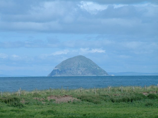
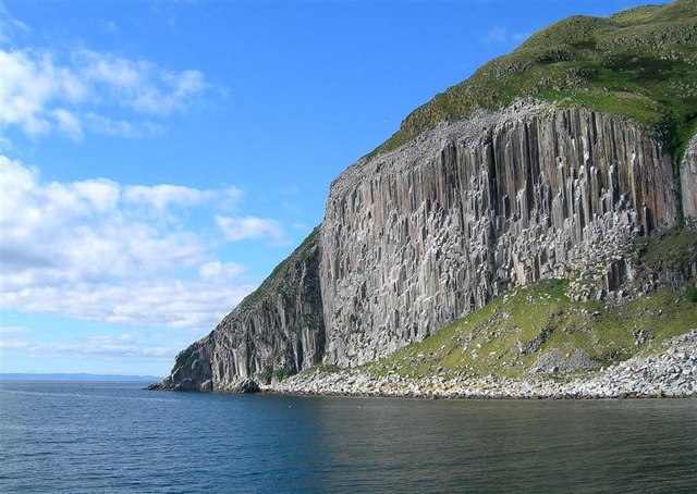
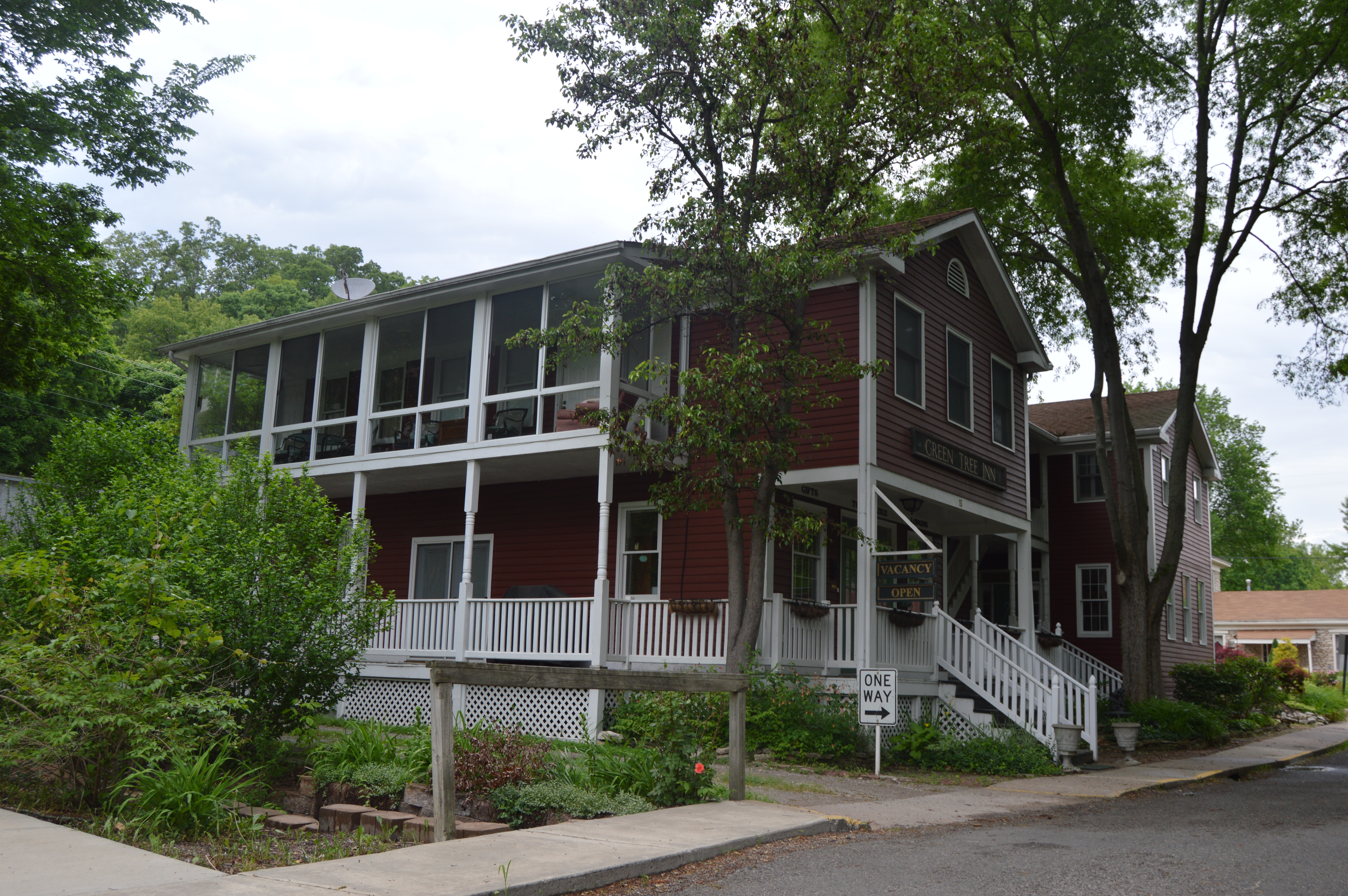
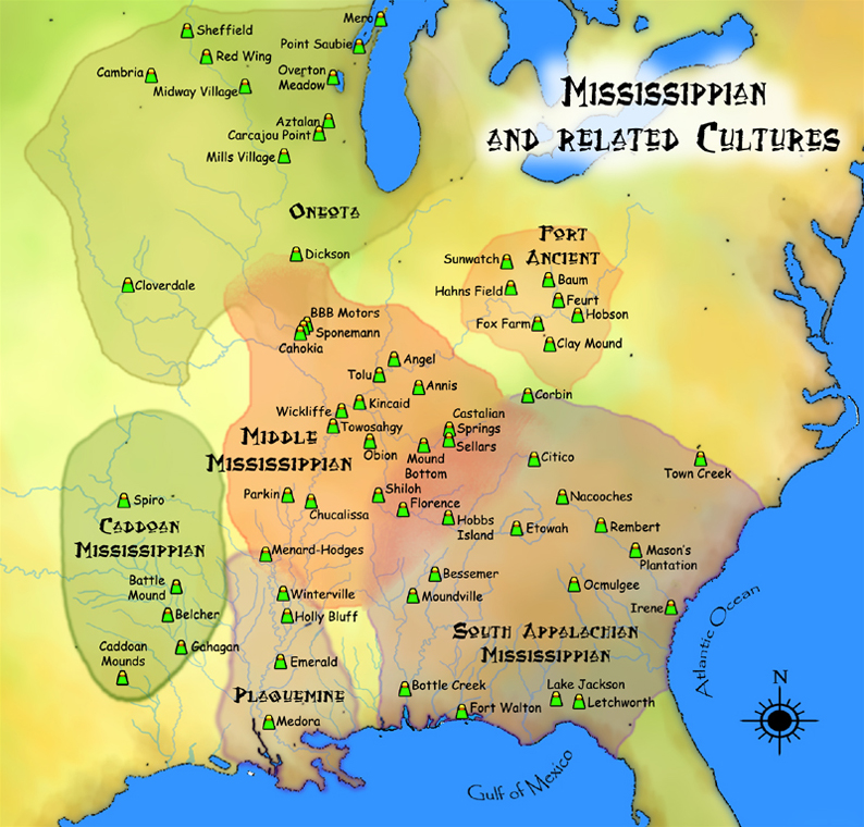
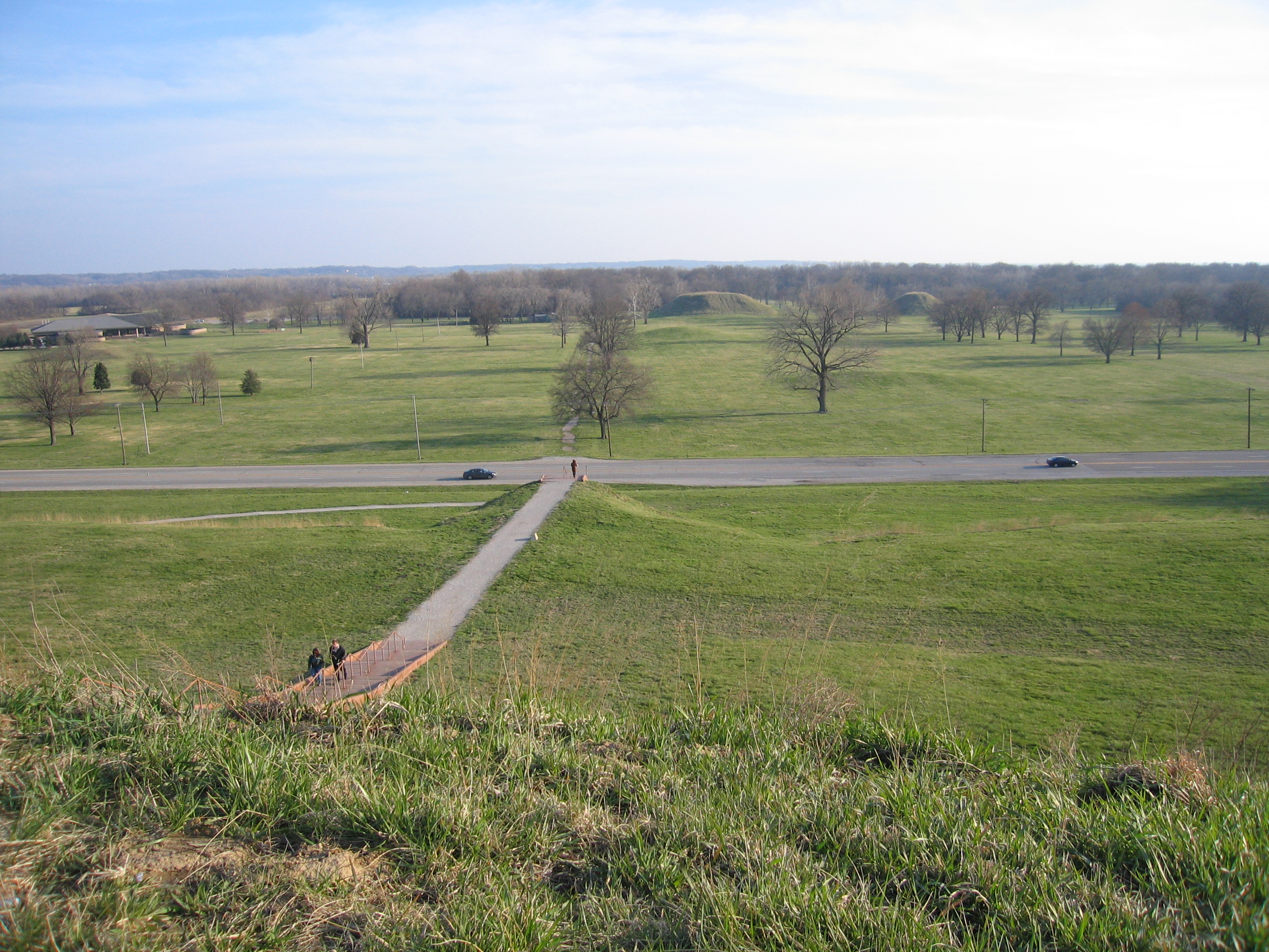
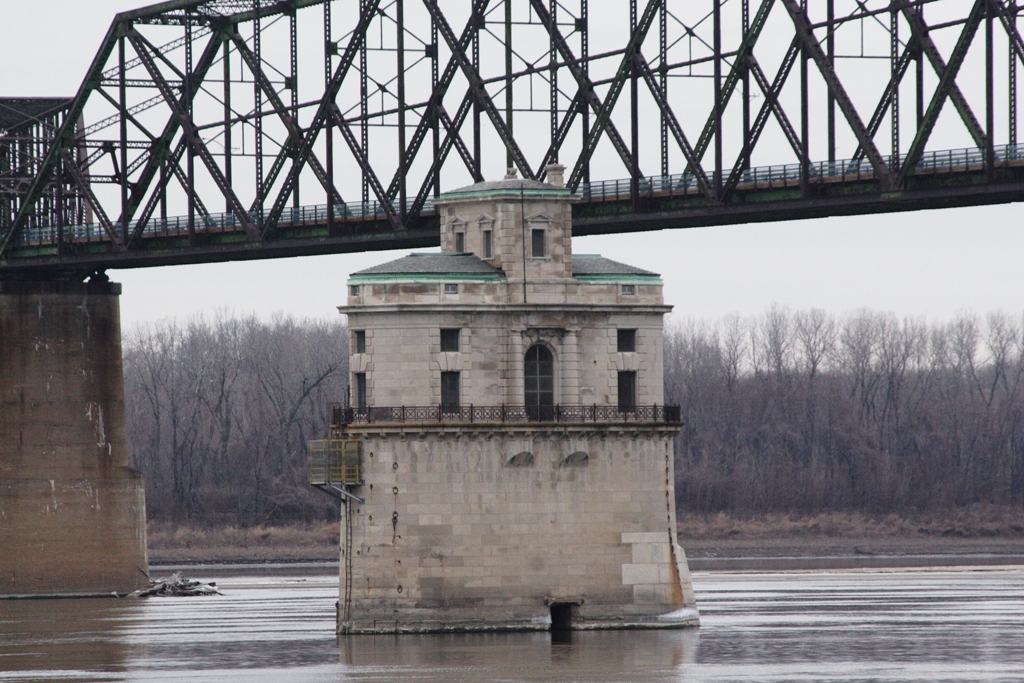
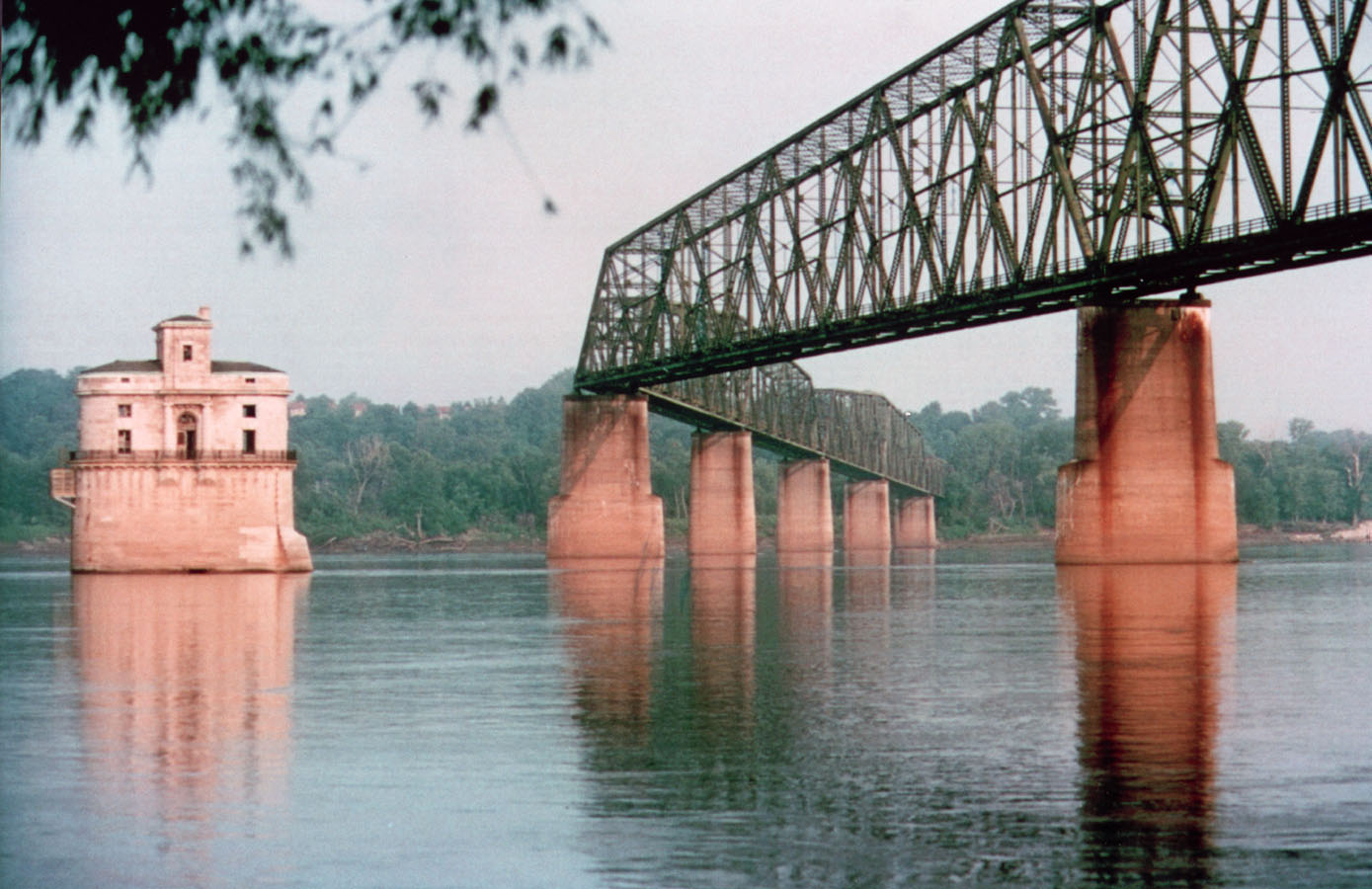
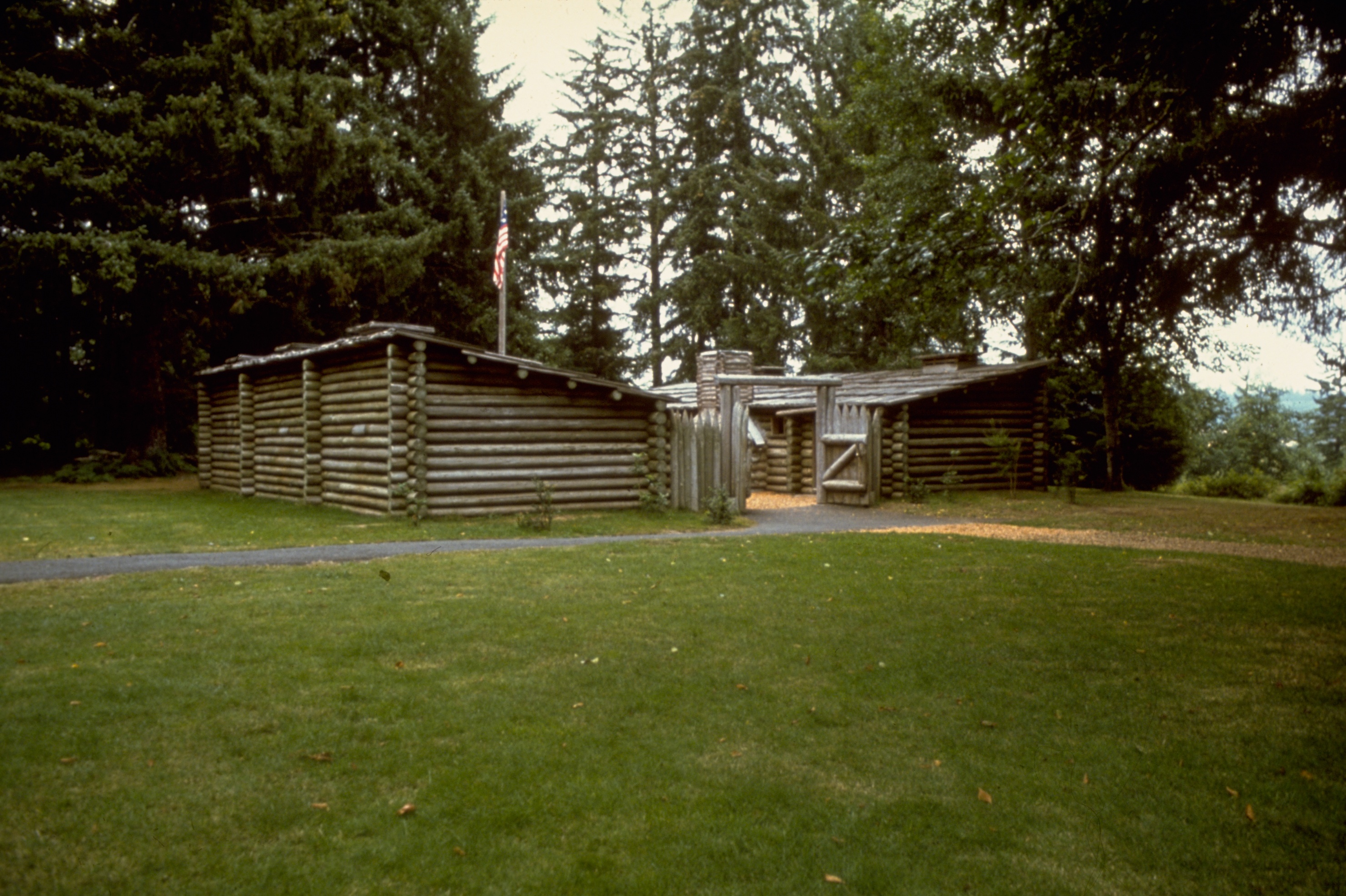
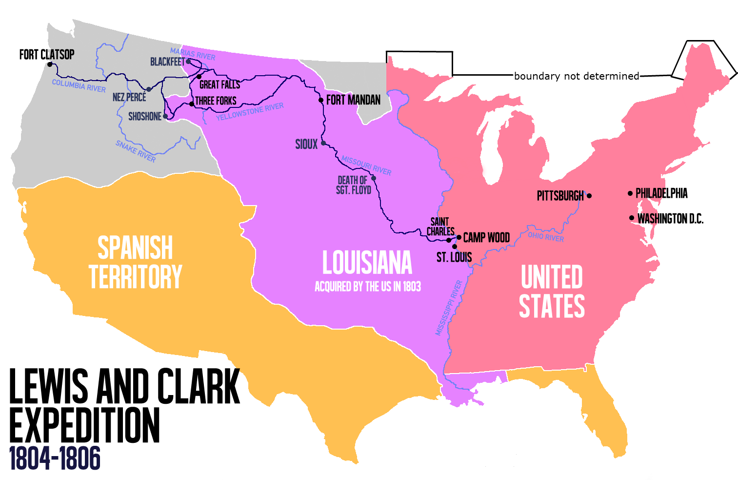
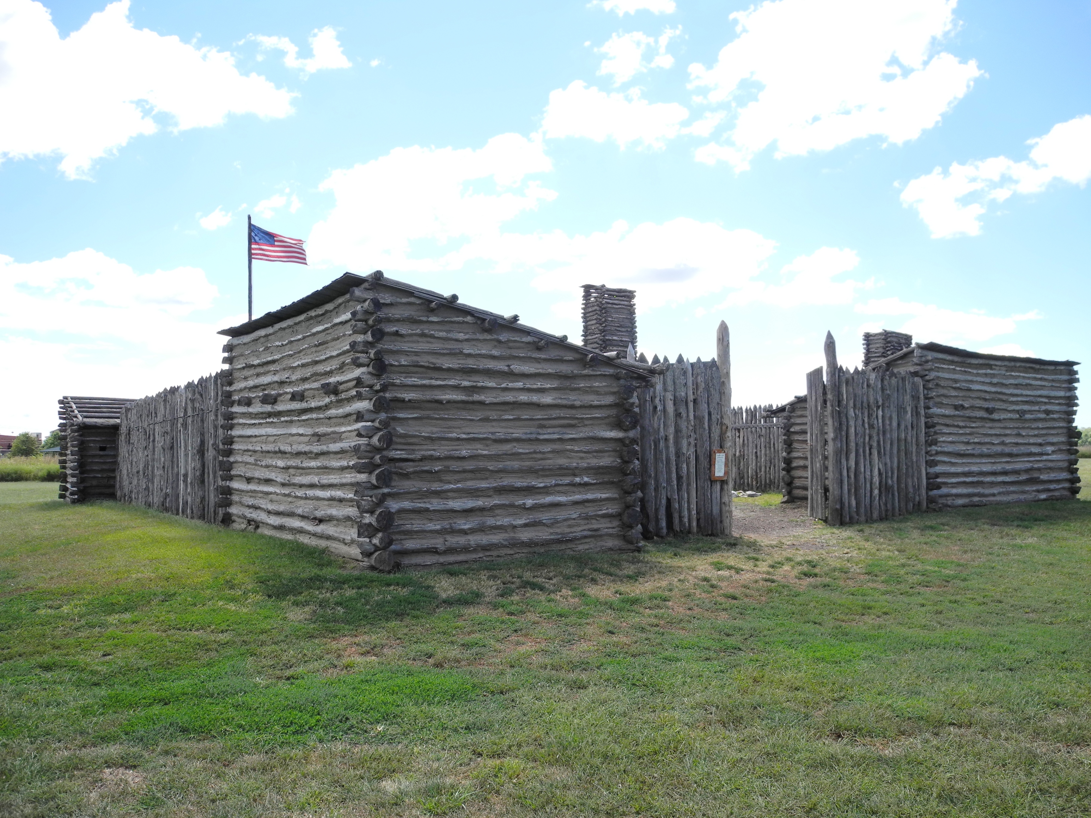
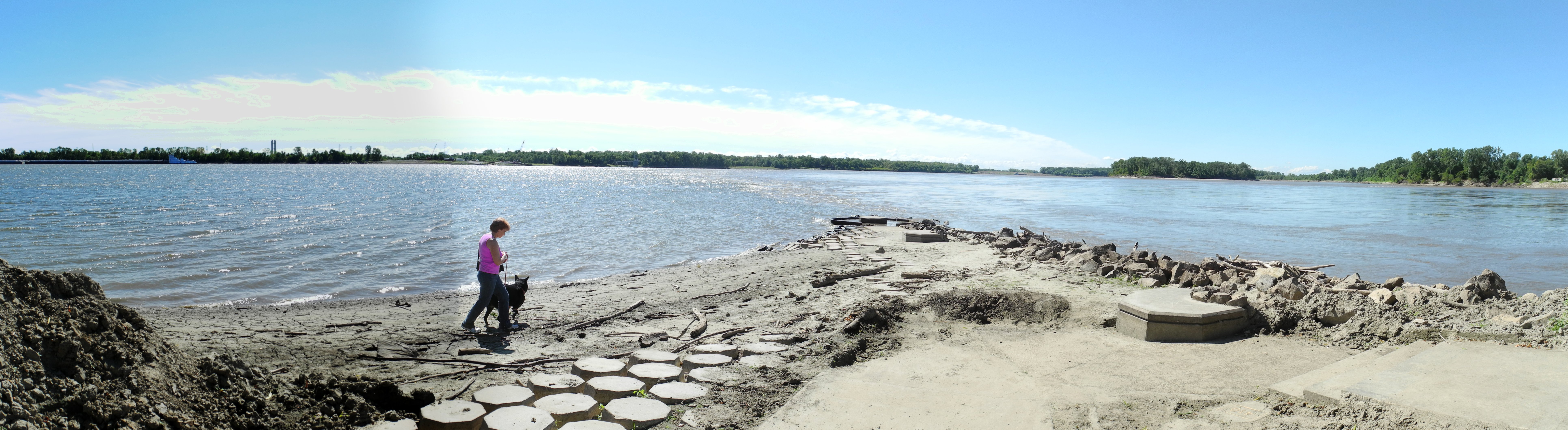
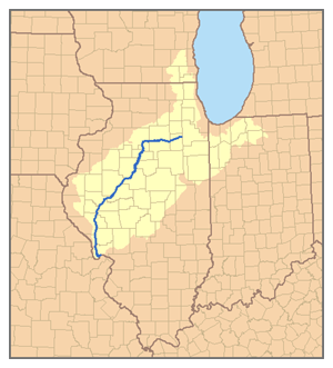
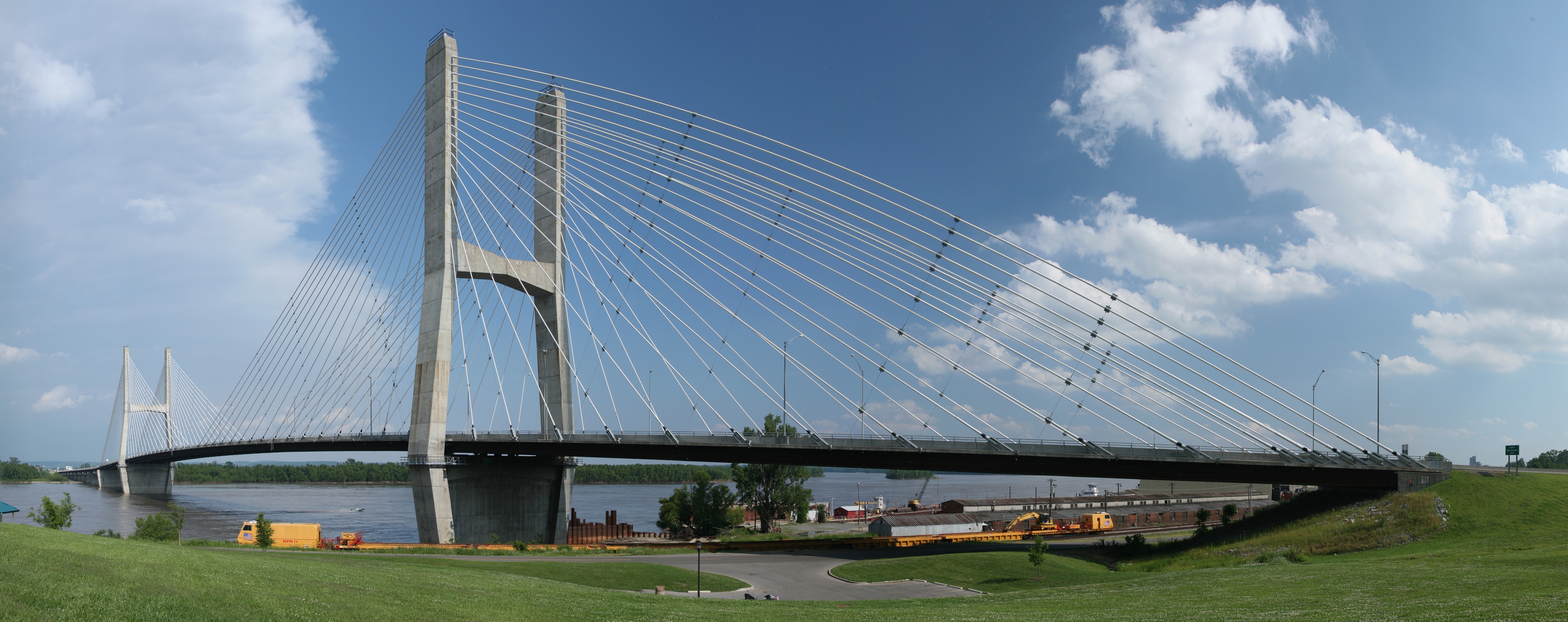