|
Reflections 2015
Series 6
April 13
Mississippi River II: Natchez - Natchez Trace
| | We have now moved from Galveston, across a string of historic areas, into the southeast corner of the original United States, which I like to call the Point, near Natchez. Today the Point is hidden in plain sight (copy and paste):
http://www.sitesatlas.com/Flash/USCan/static/MSFH.gif
| | | | It's known only to those with a historical map in their hand or in their head, as merely an inconspicuous angle in the border of contemporary Mississippi, where we're about to spend some quality time, quite contrary to some images that may still float around in one's mind, right next to that historical map up there. | | | | Keep this map handy, and click on it to look closely. Coming up that attractive Highway 61 from Baton Rouge we cross the border of the original United States just barely to the east of the Point. Highway 61 at this point is classified as the Great River Road (GRR) on the east bank, and it's somewhat away from the river. But at Natchez it's closer. From there, we'll visit the historical path called the Natchez Trace and the Parkway paralleling it (see map). In the next posting we'll go to Vicksburg, the battle of which, combined with that of Gettysburg, effectively ended the Civil War. We'll then cut over to north-central Mississippi to Oxford to visit the historical and literary connections at Ole Miss, the University of Mississippi. That will end the sojourn in this state, since we'll cross into Tennessee at Memphis to take the American Queen steamboat down to New Orleans. | | | | This is just an early introduction to the road, which really exists only in bits and pieces—a county road here, a US highway there. We'll use the GRR only as needed to fill in the areas between the two times we'll be on the steamboat, now and in September. And even from the car, we'll have to leave the GRR to drive across the river in order to see the river, since levees will be in the way otherwise. Start at the top, where the Mississippi starts at Lake Itasca. The GRR is a single route here. After the Twin Cities, the GRR exists in two sections, one the east and west banks. Work your way down to where we are now. You can now see the Natchez Trace Parkway in dots out of Natchez. We'll discuss Louisiana later, when we get there. | | | | On the upcoming September trip, I'll be introducing two more terms I've made up, along with "the Point", that help me to understand the history involved in this region. I'll refer to the shape of the Upper Mississippi, the Ohio, and the Lower Mississippi as "the Y", since that's the shape they form and that's how older and newer US territories were divided. We'll also end up way up north with a spot of land I'll call "the Dot", which I'll explain at the time. For now, let's say the Dot in the NW of the Y is the mirror image of the Point in the SW of the Y. That will become clearer later. | | | | Natchez Overview It always helps to be able to see just where you're going! Copy and paste this link to a great map of Natchez, and click to enlarge:
http://www.tripinfo.com/maps/MS-Natchez.jpg
| | | | The city grid is petite, just that diamond-shaped area near the river. This is an area largely of townhouses and closely-set private houses, and more than a few 19C mansions. The suburban area is that larger area to the right of the diamond, which was countryside in the 19C, and which also has its share of 19C mansions. In red, our Highway 61 comes in from the south, and joins 84 coming over the river from Louisiana. They continue north together, as the GRR, but we'll not be using them, since we'll leave on the Natchez Trace Parkway, in green. | | | | To the left of the diamond are substantial bluffs overlooking the river, a distinctive feature of the town. Across the river is Vidalia LA, which is on flat land and so requires a levee along the river. Natchez does not, because of the bluffs. Look over at the river for Silver Street (also on the inset map). It descends along the bluffs to the boat landing at river level, which another street has been added to make a one-way loop road coming back up the bluffs. This low area next to the river, a quiet backwater today, is called, appropriately, by the charming name of Natchez-Under-the-Hill, and is replete with history. Down here by the river, as well as atop the bluffs, is where the Natchez Indians lived. This is where the modern town started until it expanded and had to back its way uphill to spread out on top of the bluffs. This is where the Natchez Trace originally started. This is where the first steamboat in Natchez docked in 1811. | | | | The Natchez are Native Americans who originally lived here. Their language has no close relatives, so it's considered a language isolate, such as Basque is in Europe. The Natchez are one of the Mississippian cultures, and one of the few that survived into the period of European colonization, whereas others had declined a century or two earlier. It was a matrilineal culture, with descent coming down along female lines. Around 1730, the French defeated and dispersed the Natchez, selling some into slavery in the West Indies. Others took refuge with other tribes, and survivors today are in Oklahoma and South Carolina. | | | | I've found a marvelous Franco-Natchez cultural artifact. The French artist Eugène Delacroix had read a novel about the Natchez, and the result was this painting called simply Les Natchez / The Natchez, painted in 1835. The setting is what was then French Colonial Louisiana, which apparently came up as far as Natchez at the time, and shows Natchez parents with a newborn on the banks of the Mississippi. It hangs in New York's Metropolitan Museum of Art. | | | | Based on archaeological excavations, the Natchez area has been continuously inhabited since the 8C CE. That time period of course covers indigenous peoples through European settlement, so when French colonists established modern Natchez in 1716 and named it for the tribe, they were really just continuing a long history of settlement. Its strategic position on the buffs over the Mississippi ensured that it would become a major center of trade and commerce. Then in 1779, our old friend from Galveston, Bernardo de Gálvez, captured Baton Rouge to the south, and the area captured included Natchez. (While we picture the French and Spanish on the other side of the river, in earlier times, borders and captured areas fluctuated. I also recall seeing a historic marker in Natchez about Gálvez.) | | | | The grid of Natchez streets we see on the map today was laid out by the Spanish in the 1790s. I noted when there that all these streets are rather narrow, so that most today are one-way, making you keep your wits about you when driving around town. The narrow Spanish Natchez streets are in stark contrast with the wide German Fredericksburg streets in Texas. | | | | Given its age and lineage, it shouldn't surprise that, when the area became part of the original United States, Natchez served as the capital of the Mississippi Territory, and later of the state of Mississippi. Modern Natchez was already 106 years old when Jackson replaced it as state capital in 1822. | | | | But we picture Natchez as the home of antebellum mansions and plantations, and that's because, in the middle of the 19C, many wealthy Southern planters moved to Natchez and became residents, developing into a local planter elite. But there's a slight variation to what one might think. The mansions weren't necessarily located on the actual plantations. Too often we maintain an image of Tara's mansion on the Tara plantation, and that is often accurate, but what if the owners decided to build their house somewhere else, say in Atlanta? Just as there are wealthy farmers and ranchers today who don't necessarily live on their farms or ranches, that was the case with some planters, who instead built the Natchez mansions. For the most part, the mansions were in and around Natchez because of the high ground. The plantations themselves tended to be on large tracts of land in the adjacent lowlands of Louisiana and Mississippi, where enslaved labor grew sugar cane and cotton. | | | | | | That fact makes me reflect on two things I saw on this trip. Out of St Martinville I described the sugar cane fields and processing plant I saw, and later on, leaving the University of Mississippi at Oxford, I'll mention the three places along the highway which were very clearly cottonfields. The type of labor is different, the products remain the same. |
| | | | Natchez, though, became the port through which these crops were exported up and down the river, both to northern cities, and down to New Orleans, which, in turn, exported much of the crops to Europe. Agriculture remained fundamental to the area until well into the 20C, when part of the decline in agriculture can be attributed to the decline of steamboats, which we'll get to later. | | | | Keep several very informative facts in mind. Before the catastrophic period of the Civil War, Natchez had the most millionaires per capita of any city in the US. When Mississippi voted to secede from the Union, because many of the planter elite in Natchez had friends and family in the North, and generally opposed secession, Adams county around Natchez and Warren County around Vicksburg were the ONLY counties in the state to vote AGAINST secession. This is particularly poignant when one considers the siege and Battle of Vicksburg. But it also might explain why Natchez readily surrendered to Union forces after the fall of New Orleans in May 1862. When it surrendered, General Grant occupied Natchez in 1863 and set up headquarters in Rosalie, the mansion just above Natchez-Under-the-Hill. The surrender, in turn, explains why Natchez never suffered the destruction that other Southern cities did, and why it boasts today having more antebellum homes than any other city in the US. The wealth of architecture in these mansions forms a major part of the cultural identity of Natchez today, leading it to become a popular destination of what is called heritage tourism. | | | | Grand Village of the Natchez Natchez is the oldest city on the Mississippi, since it descends from the first known settlement, the Grand Village of the Natchez, a complex of ceremonial plazas and earthwork mounds that date from about 1200 CE and were started by an indigenous pre-Natchez people. They built three platform mounds in stages, and an adjacent ceremonial plaza. A later phase of construction, dating to the mid 15C was named for the Natchez, who then used this site in the late 17C and early 18C. The village was the main political and religious ceremonial center of the Natchez people, and replaced the Emerald Mound Site on the Natchez Trace, which we'll also visit later. Knowledge of the mounds comes to us from a number of French colonists who witnessed the use of the mounds and recorded their observations. But then, after being defeated by the French settlers in 1730, the Natchez abandoned the site. The 52 ha (128 acre) site of the Grand Village of the Natchez is now a National Historic Landmark. | | | | Let's start touring Natchez. Although it had been a long drive from Galveston, breaking it up at St Martinville was a pleasure, and it seemed we could fit in one more quick stop. We'd told the lady at the b&b that we'd be in by the 5 PM check-in time (or otherwise call), but it's before four when we pull into town, so we do have time for the short stop that we'd planned. | | | | Go back to our map and find Highway 61. Before it splits, we turn right at Jeff Davis Boulevard (this IS the south, after all), which turns out to be a pleasant residential street with a wide strip park down the center, a nice atmosphere to start our visit in. It's only about three blocks to where the road bends, and right there, on the south side, reaching down to the St Catherine Creek, was the entrance to the Grand Village of the Natchez (misplaced slightly on the map). It just seemed right to visit an ancient site as the last activity of today before visiting the mansions tomorrow. | | | | But first a comment on Indian mounds. It's easy to get excited when visiting the native civilizations in Latin America, the Aztecs, Mayas, and Incas. Even with much of their cities in ruins, there's lot to see. In North America, not so much. The Mesa Verde cliff dwellings (Photo by Massimo Catarinella) in Colorado (2007/14) are very impressive, but one is hard-pressed to be impressed by other manifestations of ancient native cultures, which tend to be small, grass-covered hills. (An exception is Cahokia Mounds in Illinois, one of the first things we visited on the start of our Grand Tour in 1968, which we'll revisit in September.) Still, culturally informed and responsible people should be willing to appreciate even these simple manifestations of ancient culture, shouldn't they? | | | | The site is attractively treed, and no other visitors are there on a late weekday afternoon in November—no surprise. A very quick stop in the museum to get a map of the grounds—there are pottery displays—and off we go. There are a couple of reconstructed huts, open grassy ceremonial plazas, and a first mound, an abandoned one, probably because of erosion caused by the creek. | | | | The second of the three mounds was the most important, the Great Sun's Mound (Photo by Herb Roe). The Great Sun was the paramount chief of the Natchez, and lived in the Grand Village. When the chief died, his wives and servants were strangled with due ceremony to accompany him into the "next life". His house was burned, and the mound was raised to a new height for his successor's house. | | | | The third mound is the Temple Mound (Photo by Uyvsdi). In the temple, a sacred perpetual fire, symbolic of the sun, from which the royal family supposedly descended, was kept burning day and night. Special attendants maintained the fire, and if the fire died, so did they. The temple housed bones of previous chiefs, and was where their funerals were held. | | | | The French accounts describe both these mounds and is the source of current knowledge. The mounds stand today about 2.4 m (8 ft) high, but would have varied in time, as structures on them were demolished and rebuilt. But I will repeat: when visiting Indian mounds, you are in a park with small grassy hills, which some would describe as "nothing to see". The educated person has to stimulate his or her own intellect to appreciate what there is to see. | | | | Wildlife I am not a hiker, but have said that I enjoy short walks on designated trails principally in parks such as these. But then there's the wildlife to warily keep in mind, although nothing has ever happened to me. In 2008/29 I described stopping in Redwood National Park in California and wanted to take the one-hour trail through Lady Bird Johnson Grove to see the redwoods. When I got there, I saw the sign saying that this is bear and lion country, and you should try not to walk alone on the trail, and also should keep on making noises as you go along. Well, there were a few people around, but for an hour I kept on looking over my shoulder as well as looking up at the trees. Then, when on the Cabot Trail recently in Nova Scotia, I was about to set off on a short trail to see the Lone Shieling, a reconstructed Scottish cabin, but a warning sign said to be wary of the coyotes, and to use a stick to keep them away. Worse, hikers had actually left two sticks taller than me leaning against the sign. I gave up and didn't go, but got to see the cabin moments later on the side of the road from the car. So what encounter with wildlife might I have had in this bucolic park? Any guesses? | | | | The circular path was dirt, with fallen leaves on both sides, similar to what you see in the first mound picture above. I had walked clockwise around it for maybe a quarter of the total distance when I spotted a rather large sign planted in the leaves to my left. It was the wildlife experience that takes the cake. I wrote down the chilling wording verbatim:
CAUTION: VENOMOUS SNAKES IN AREA
| | | | I know that the South is known for copperheads, cottonmouths, and rattlesnakes, and here I was, wearing sandals and shorts—minimal protection--with all those leaves on either side of the dirt path. Actually, the site was small, and you could see the mounds from where I was standing, so continuing wasn't all that necessary. So my choices were to backtrack one-quarter of the way or to proceed three-quarters. Well, I took the high road, and finished the trail, but I alternated between looking at the mounds and watching the piles of leaves on either side of me. When I got back to the car in the parking lot, I looked under it before getting in. Well, the experience added spice—and not a little adrenaline--to a long driving day. Ah, the joys of nature. | | | | Visiting Natchez On the map, note how we leave this area, go up a ways on 84, then cut into town on a road that brings us to Orleans Street. We make a left at Commerce Street and, a couple of houses down, is the b&b, Bisland House. It isn't a mansion like the Clockmaker's House in Nova Scotia, but is a comfortable, 1904 upper-middle class house where the owners live, and rent out three rooms as a b&b. On the rotating slide show you'll see how nice the living room and entry hall are. When you see one of the pictures of the façade, my room is upstairs on the right, with access via the hall to the upper porch. It was nice stepping out there before breakfast, facing the morning sun. A typical breakfast is also shown on the slide show. | | | | Click on "Rooms". First for a vocabulary lesson on Southern terminology. When I was touring the houses, the guides kept on referring to a "tester bed" or a "half-tester bed". It took a while, but I caught on that those are terms used, at least in the South, perhaps elsewhere, for what I otherwise would call a four-poster bed—when there are four posts--or a canopy bed, with four or fewer posts. Now read what it says about Danielle's Room, then click on the plus on the picture to inspect a half-tester bed. | | | | But I had arranged for the smaller, less expensive room, so click on the picture for Michelle's Room. I really liked this room, and especially remember that cozy corner with the easy chair and direct lighting. It also had a hospital-type meal-serving tray that was ideal for the laptop for writing. Nice, cozy memories. When I got to the house and signed in, the hostess showed me where there were coffee and pastries in the dining room, so it was a pleasant arrival. | | | | Natchez-Under-the-Hill I had thought carefully in advance what I wanted to do on the one full day in Natchez so I wouldn't waste time making last-minute decisions, and it all fell nicely into place. I will assume you have the Natchez map handy throughout the entire discussion of the city. To start, it was a short drive after breakfast to the top of Silver Street to go down to see Natchez-Under-the-Hill. | | | | To recap, this area is associated with the Natchez Indians, and is where the Natchez Trace began, but as for the contemporary city, this was once ALL of Natchez. There were some 20 buildings along the waterfront at the time of the American Revolution, but later on, the town spread up the hill to the bluffs. It served as the Natchez Landing then as now, although with much fewer rivercraft now. In its heyday, Natchez-Under-the-Hill, as you might suspect from a waterfront area, was teeming with gamblers, river pirates, highwaymen, sex workers—use your imagination. In 1810, it was described as a place for which, given its small size, you could not find "a more dissipated spot". It was the "bad twin" of tamer Natchez on top of the bluffs. But today, . . . (copy & paste):
https://www.stevenbrooke.com/wp-content/uploads/galleries/post-432/full/natchez013.jpg
| | | | . . . as you come down bucolic Silver Street (from the left), you find in the landmarked buildings a café, a gift shop, a bar. Behind you is the boat landing proper running along the street, and at the far end of it, is the ubiquitous Mississippi casino (copy & paste):
http://www.terragalleria.com/images/us-se/usms38052.jpeg
| | | | Mississippi is one of those states that legalized casino gambling, not on land, but on water only. As reported in 2008/2 when driving along the Gulf coast at Biloxi, the casinos floating at the beaches that had been damaged by Katrina were being repaired. Well, what's good for the Gulf Coast is good for the Mississippi River, so both Natchez and Vicksburg (maybe more) each have a floating casino—and here it is in Natchez. Of course, they're made to look like steamboats, but I believe it's all a façade, and they're nothing more than barges that can't even propel themselves. I think floating is the only prerequisite to follow the letter of the law on casinos. Anyway, further up the landing is where the American Queen docks on its visits, and so where we will be returning to Natchez in seven days. | | | | The Mansions Since 1932, historical and cultural events called Natchez Pilgrimages have been jointly produced by the Natchez Garden Club and the Pilgrimage Garden Club. They each last several weeks, originally just in the springtime, now also a second one in the fall, and tour the stately antebellum mansions in the city, many of them private. The Spring Pilgrimage this year covered 24, the Fall Pilgrimage 19. I understand costumed descendants and friends of each house lead the tour. Similarly, individual visitors at other times can do their own personal "Natchez Pilgrimage Tour", and a special discounted ticket is sold covering any three homes one chooses. Close to a dozen are available, as listed here. Now in 2008 I described visiting seven stately homes like this along River Road in Louisiana, and spending the night in two of them, so which ones to choose here could have been a problem. But that's the advantage of a guide like Michelin, which gives star ratings. Michelin gave three stars each to two of them, and two stars to others, from which I chose two two-star ones. I figured I'd use the discounted ticket for three, then visit the fourth individually, and it all fell nicely into place. Look at the listing on the website. We'll first visit Longwood and Melrose, three stars each (out of three), then Stanton Hall and Rosalie at two each. As it turns out, two are in town, and two are out on the edge of town, originally in the countryside. We'll start on the perimeter, and then work our way back into town. While it's a chance decision, it'll turn out to be a wise one.
| | | | Longwood Let's backtrack from Orleans Street down that entry road we used, but then cross 84 to Lower Woodville Road. Quite promptly we see the right turn to the Longwood grounds. I knew Longwood was special, but the more I ponder it now, the more special it becomes. To be very blunt, a lot of these mansions are similar. Not only these here and in Louisiana connected to plantations, but any stately house, such as those along the Hudson Valley and elsewhere. Enjoying the elegance of a stately house is very pleasurable, and an introduction to elegant living, particularly in the past; different architectural styles present a visual variety, but then they all start seeming the same: fancy dining room, spectacular ballroom, attractive bedroom, then yadda, yadda, yadda. You really need something very special to make a place stand out. A case in point: Casa Loma in Toronto (2011/29). In addition to the elegant rooms, it has its spectacular location with a view across the city, and then of course, the story about how the original owner lost it all. THAT's what makes a stately house stand out from the others. In this regard, I'd say Longwood (Photo by Carol M Highsmith) in Natchez stands out head and shoulders above many, if not most, others. | | | | It has very elegant architecture, unusually striking even from a distance, as one drives onto the property through the live oaks and Spanish moss. It has an incredible story. It has the poignancy of the loss of a great dream, and, as with Casa Loma, the loss of a great fortune. Most spectacularly, it tells a HUGE LIE, because there's really "nothing there" behind that gorgeous façade. Yet that "nothing" makes a great spectacle. | | | | There were just three of us on the house tour, a couple and myself, even though Longwood was the only stop I made on this entire trip where an entire tour bus stopped as well. Other guides were bringing the horde through the building while our guide kept the doors closed so we weren't interrupted by them. It just shows the interest in Longwood and how it's different. | | | | It's difficult to know where to start. Invaluable information I got nowhere else came from the lady who led the tour; I already knew some other background, and, as usual, have learned a great deal more after the fact while preparing this posting. Let me start with a chaotic barrage of facts, to some extent as I learned them. It won't be quite Pinteresque, who used reverse chronology in the 1983 film Betrayal, it's more like Stanley Donen's 1967 film Two For the Road, where the scenes jump out of sequence forward and back in time until the whole story ends up being told. | | | | Longwood is mostly an empty shell, albeit a gorgeous one. The Civil War ruined the owner financially. Longwood is octagonal. The family lived in the basement. Civil War fighting did not come near here, so there was no physical destruction. The architect was from Philadelphia, and brought his own craftsmen from there. Longwood is the largest octagonal residence in the US. The architect was famous, particularly in the Northeast, but his most famous work is the unfinished Longwood. This incomplete building is on the Register of Historic Places and is a National Historic Landmark. The curious facts just swim around until you make some sequential sense out of them. So let's try. | | | | A cotton planter with the curious name of Haller Nutt, his wife Julia, and their eleven children were a wealthy plantation family--he had three plantations in Louisiana and two in Mississippi--who decided to build a mansion in Natchez. As I commented to the guide at the time, I'd give the house the nickname "The House of Unfortunate Timing", since it was the timing and other decisions Nutt made that was the downfall of the house and his personal downfall—yet it wasn’t his fault. It was the times, when the United States was breaking in two. One other nickname for Longwood that I refuse to use, because it's so unfair, is "Nutt's Folly". Despite all the bad luck at Longwood in the 19C, today Longwood is probably the most popular location for visitors to Natchez to see, so it's as much a folly as Alaska was Seward's Folly. | | | | The Nutts wanted a showplace. In the spring of 1860—in retrospect, an ominous date, with the Civil War looming--they contacted one of the preeminent architects of the day, Samuel Sloan in Philadelphia, who was also a best-selling author of architecture books at the time. It should be noted that Nutt was looking at the United States as a unified whole and, even though Sloan was from the North, apparently Nutt still wanted quality. It should also be remembered that sentiment in the Natchez area (also Vicksburg) was pro-Union enough so that those counties were the only ones voting against secession of Mississippi. Perhaps choosing Sloan was a gesture in the direction of continued unity, and normalcy. | | | | A bit of research shows that octagonal houses enjoyed a brief, but extensive, flurry of popularity in the US and in Canada starting in the 1850s. As built in North America, they are properly called octagon houses. There are hundreds of these Victorian-era houses remaining, one estimate being over two thousand. But they were never built in clusters. Rather, they were the choice of individualists, who wanted to stand out among their neighbors who chose more conventional living, in rectangles. | | | | | | Actually, it's a more efficient design, deriving from the geometry of the octagon. It was claimed that they were cheaper to build, had more living space, got more natural light, stayed cooler in the summer and were easier to heat in the winter. Comparing an octagon and a square of the same perimeter, the octagon encloses a bit over 20% more space (Sketch by ProfDEH). |
| | | | In 1852, Sloan had published a book called "The Model Architect" which included many illustrations of possible homes in the style of the day. One of the lithographed plates was of an octagon house entitled Oriental Villa, which apparently intrigued Nutt enough so that it became the inspiration for Longwood. Eastern styles were popular in the day, and this style is referred to variously as "Moorish Revival" or "Oriental Revival" and included the Byzantine onion-shaped dome with a finial on top, | | | | Poignantly—and historically significantly--Longwood was the last burst of southern opulence before war brought the cotton barons' dominance to an end—so much the last burst that it didn't get competed. It was designed in 1859. Construction actually moved quite quickly, since everything that's there today was built within a year, between 1860 and 1861. But that year was fateful: Mississippi was the second state to secede, on 9 January 1861, and hostilities began on 12 April. At that point, all the workmen stopped work and went back to Philadelphia (I can just visualize the steamboats going north!). As the guide pointed out, fortunately, the dome had been tinned before they left (see above picture), otherwise the weather would have destroyed the house over time. | | | | If they'd started a year earlier? If they hadn't completed the outbuildings first? If Nutt hadn't been so ecumenical and had used a Southern architect with local workmen? Perhaps there would have been time to continue working and finishing Longwood, but that's pure speculation. Still, Longwood is considered Sloan's most famous building. | | | | There were invaluable details I got from the guide about the incredible emotional and financial stress put on Nutt. Although he was a wealthy man—his fortune was estimated at three million dollars before the war--like any farmer, he depended on his annual crops. Early on, the Confederates burned a million dollars' worth of Nutt's crops—perhaps it was part of a scorched earth policy, so the Northerners wouldn't get it. But the next year, when the Northerners had taken over Natchez, despite the fact that Nutt had letters of protection—he was a cooperating "good guy"—the Northerners burned his crop as well. He was ruined. | | | | There are six levels to the house. The view from the front we just saw in the above picture shows only five. The entry is at the Principal Level, with a second floor above that, plus small tower levels. There is an observatory on top, which had (has?) a view of the Mississippi. It's this entire upper part of the house that is the empty shell. It's only when you go around the sides of the house to the back that another secret is revealed. Because of the slope of the land, there's a lower floor, underneath the Principal Floor. While its access is today from the sides and back, it's also open in the front, behind the entry steps. It's the basement level, and the secret is, this is the only completed part of the house, and where the family actually lived. They moved in early on, planning on living down below while the house was being completed above, and then moving on upstairs. As disaster after disaster struck, they realized they'd be stuck downstairs and never inhabit the upper levels. And they never did. | | | | Haller Nutt died in the lower level/basement of Longwood at the age of only 48 in 1864, reportedly of pneumonia, although one can imagine the stress he was under. Julia and the family, struggling, lived there until her death in 1897. She reportedly maintained a vegetable garden to supply produce for her family on what was meant to be regal estate grounds. The house remained in the family until 1968, and barely survived decades of neglect and near abandonment. Yet once it was taken over by the local garden clubs and restored as a museum, it became one of the most popular attractions of Natchez. | | | | It's time for us to visit Longwood. Of the 32 rooms planned for the house, only nine in the basement were completed. I have lots of pictures and maps to give an idea what its like, but as usual, I'm allowed to link to only those that I know are in the public domain. Since I don't know of the legalities of my linking to others I've just found on the web, as usual, you'll have to go get them yourself as a third party. There are floor plans displayed in the house. Copy and paste this one of the basement level, where the tour starts:
http://betweennapsontheporch.net/wp-content/uploads/2014/07/Basement-Plans-for-Longwood-Plantation.jpg
| | | | But don't believe a word of the labeling. That shows what was intended for these rooms to be once the family hopefully moved upstairs. They're incidental rooms, an office, school room, smoking room, playroom, billiard room. It reminds one what one might find today in the basement of a fancy house. Don't be misled by the Rotunda in the center, since it's just the center room with a normal ceiling. Upstairs, on the Principal Floor above this is the actual open atrium leading up to the tower and observatory. And normal ceilings they were. This being the basement, there were no impressively high ceilings, just those of average height. | | | | Since none of these rooms was used for what the floorplan says it was, what were they? These rooms saw duty as bedrooms, a dining room, living room, whatever the family needed who was stuck living in the basement. I've been able to dig up two pictures. Copy and paste:
https://c1.staticflickr.com/3/2347/2113899414_d5db6c310e_z.jpg?zz=1
| | | | So we see one of the rooms that served as a bedroom. I believe it's probably in the outer ring of rooms on the floor plan. While it's nicely done, it's no palace either, and in another house, there'd be no reason to show a picture like this. But it's a 19C middle-class room, with basement-height ceilings. With eleven children, there is more than one bed per bedroom. You can see you're in an octagon house because of the unusual shape of the walls. And now it's time for a pop quiz. What again was the name for four-poster beds in the South? | | | | Both these beds are tester beds. The other picture is of the dining room. Copy and paste:
https://c1.staticflickr.com/3/2212/2113118977_089b04bc5f.jpg
| | | | It's quite nice, and the lozenge-shape of the room reminds me that this was probably located in the inner ring of rooms, right around the Rotunda. (You have to imagine our guide leading us through some rooms while those tour groups were behind closed doors in other rooms.) You can see one of the 26 fireplaces the house was going to have, and a comfortable dining table. Above it is what is called a punkah, or a fly fan. Research shows that, as you might suspect, is a Hindi word, with traditions in India that go back to 500 BCE. You can see the rope leading to where a servant would cause it to move back and forth, shooing the flies. I also saw one later in Melrose. | | | | No connection to the upstairs was ever built originally, nor were there any steps up to the (useless) main entrance upstairs to the Principal Level. When the garden clubs took over the building, they added a utilitarian staircase from the basement to the Principal Level, and built the outside staircase, so that visitors could leave directly from upstairs without returning to the basement. | | | | So we grit our teeth and go up one level and see this (copy and paste):
http://media-cdn.tripadvisor.com/media/photo-s/01/a4/34/5a/longwood-house-obergeschoss.jpg
| | | | It's been neatened up from when the workers left, but those are bare brick walls, which would have been beautifully plastered. One can imagine what statues were planned for those niches. There is no access for the public to the workmen's stairs remaining from a century and a half ago going up to the second floor and beyond. Ahead you see a floor plan, and it's located in the actual circular Rotunda, with atrium space going way up to the observatory. First, let's take a closer look at that floor plan of the Principal Floor:
http://www.newsouthernview.com/images/nsv_ie_longwood_main_floor.jpg
| | | | Click to read the designations of the elegant rooms meant for this level, again, in two rings around the central Rotunda. The main entrance would be at the bottom, leading into the Hall. Note the two smaller dressing rooms artfully placed on a veranda. This is where the dining room was meant to be. Now let's step into that Rotunda and look up along the workmen's stairs and into the atrium at the four remaining stories above the Principal Level, up to the apparently much smaller observatory (Both Photos by Elisa.rolle). And we have one more floorplan, for the second floor (copy and paste):
http://www.newsouthernview.com/images/nsv_ie_longwood_2nd_floor.jpg
| | | | Click to see where the bedrooms were meant to be, with balconies, verandas, and even two small dressing rooms corresponding to those on the Principal Floor. As one reviews what might have been, probably the most impressive thing on this level is to see the abandoned work area left by the workmen when they left. There are also other abandoned objects, such as these trunks and bathtubs and a crate sent to Julia Nutt from someone in New York, another North-South connection. (All Three Photos by Elisa.rolle). And I particularly remember seeing this case for a grand piano (copy and paste):
http://farm3.static.flickr.com/2301/2113189833_e49787050e.jpg
| | | | Finally, there's something else that the garden clubs had to take care of. This is the original carved wooden finial (Photo by kniemla) that had stood on top of the dome, but which had rotted away. Go back to the first picture of Longwood and look at what is today a replacement made out of fiberglass.
| | | | Longwood was to have all of the niceties, including a dumbwaiter to bring food to the Principal Floor, and pocket shutters that disappeared into the wall. Because of the octagon shape, it required five-sided angled bricks, all of which were made on site. Behind the house is an attractive lawn with six live oaks in a circle. They'd been planted in advance in the expectation that a gazebo would be built in the center. There was an elegant five-seater outhouse, all made of brick. The men's side was a two-seater, and the women's side had two seats, but then a half-size child's seat next to them. A carriage house had been built, and a brick building for the enslaved workers, now used as offices and modern restrooms. One wonders if Nutt had held off on the outbuildings, maybe he could have gotten more done on the main house. | | | | Look again at this closer view of Longwood (Photo by kniemla) from the front. You can tell here that the basement is fully open on all sides, even underneath the front steps. You can see some of the 120 Corinthian columns on the verandas. You can admire the handsome brickwork all around—but surprise! It wasn't supposed to be brick. Just like the brick interior was supposed to have been plastered (as the basement was), the entire exterior was to have been stuccoed. And as we said, the front steps were added by the garden clubs to have an exit for the tours. They built it of brick to match the other brickwork, but the plans had called for the steps to be marble, with not a utilitarian brick in sight.
| | | | There is a uniqueness in Longwood that I compare with the Winchester House in San José, California. Sarah Winchester was the most eccentric and superstitious woman ever, who kept on adding wings to her house, year after year—details in 2001/10. But she eventually abandoned the original core of the building and never returned to it, which can be seen on tour. Particularly impressive, though, are the huge floor-to-ceiling cracks in the plaster in the living room, which were caused by the 1906 San Francisco earthquake, which she, quite uniquely in the region, never had repaired. It's an unusual feeling looking at walls that are screaming "1906" and "earthquake" at you, loud and clear. Well, looking at Longwood, its emptiness and the story behind it screams "1861" and "Civil War", just as loud and clear. | | | | One last treat. Finish by enjoying this 2:17 YouTube visit to Longwood. | | | | Melrose In retrospect, Longwood is so special that, no matter how nice other places are, they can't match it. We'll now move to our other house in what was the countryside. On our map, we'll backtrack up Lower Woodville and make our way through the cozy suburban neighborhood to where Ratcliffe Place faces our next stately home across Melrose-Montebello Parkway, whose name indicates that we're going to visit Melrose (Photo by Elisa.rolle). We won't take time to describe everything here, or in the two following mansions, but this one, of all the intact stately homes, is the most significant. | | | | Its first owner was a successful lawyer and planter who came to Natchez from Pennsylvania in 1830 and in 1848 hired a Maryland architect to build the grand mansion in what was then the edge of town, so such North-South connections were not unique to Longwood. They named it Melrose after Melrose Abbey in Scotland, which they had visited, and spared no expense. But the Civil War hurt him financially—we've heard that before--and he sold Melrose in 1865. The second owners rarely used Melrose and it remained unoccupied for the next four decades. Two women, formerly enslaved by that family, are credited with being the caretakers of Melrose during this period. The owners' son then became the third owner. He returned with his wife in 1900 and restored Melrose. Fortunately, instead of remodeling, they decided to keep the house intact. They resided there until her death in 1975. The fourth owners also retained the integrity of the house. Because of this maintenance of continuity, the house is still furnished in the period before the Civil War, which is a major factor in its appeal. Therefore, the fifth owner was the National Park Service, who chose this building as the principal element of the Natchez National Historical Park, as an example of the pre-Civil War period, and also of suburban villas as opposed to town houses. It was only when I heard that that I realized that my sequence of seeing two houses on the edge of town before seeing two in town not only made sense to me, but is a historically significant distinction that appealed to the NPS as well. | | | | Melrose is considered one of the most intact antebellum estates in the South since the furniture had stayed with the house from the original owners onward. Also, since Melrose has the only remaining slave quarters in Natchez, the NPS considered that that would illustrate both sides of the economic situation, slavery and the antebellum planter class, in contrast to the rosy picture of antebellum life that the Pilgrimage has always presented. | | | | Driving up, we start behind the main building. My National Park lifetime senior pass precludes any charges. It's almost a half-hour until the next tour, so the guard instructs us to review the outbuildings and other dependencies back behind Melrose. There are two-story kitchen and dairy buildings, cistern houses, a smoke house, a privy, barn, carriage house, and the slave quarters (Photo by Elisa.rolle), now a museum containing exhibits on life there back in the day. | | | | A park ranger leads the tour, and as usual, there's no one else, so it's a private tour. The Ionic columns indicate that Melrose is in Greek Revival (Photo by Rdstephens), and we see a building where the bricks WERE meant to show. There are numerous pictures available, but we'll just choose a few. This is a bedroom, and I remember the guide pointing out that the Venetian blinds throughout the house were unusual for the time. By now we all recognize a tester bed. The furnishing in the various sitting rooms, here in blue and red are quite elegant. I remember really being taken aback at the spectacular perfection of color of all the elements in the green room. And in the dining room (Last Four Photos by Elisa.rolle), we'll all now recognize not only the Venetian blinds, but also the punkah over the table, with its cord hanging over toward a window. | | | | "Melrose" by Gorham The Michelin book got me very curious about something it pointed out and set me off on a search. It said that the original furnishings remaining to this day in Melrose include a set of carved Rococo Revival chairs in the drawing room (another source says in the parlor) from whose elegantly carved, intricate rose pattern the Gorham sterling-silver flatware pattern "Melrose" was derived. Now Gorham Silver is one of the largest and most prestigious silver manufacturers in the US dating from its founding in 1831 in Providence RI, and a link between it and Melrose is an equally prestigious thing. For instance, the White House has several Gorham silver services including an impressive service bought in 1859 by Mary Todd Lincoln. So how did Melrose get involved with Gorham? | | | | The first step was to find an example of the "Melrose" sterling silver pattern (Photo by Stan Skwarek), and so we have it here in this detail of a bowl. But that tends to be easier to see in flatware, so copy and paste these two links:
http://www.silverqueen.com/sterling-silver-flatware/pictures/MelroseGorhamSterling.jpg
http://image0-rubylane.s3.amazonaws.com/shops/694606/f2782.2L.jpg?38
| | | | The first link shows a Melrose place setting for four and gives an idea of the design on the shaft of each piece, but the second one is a detail that's easier to work with. We can see how Rococo Revival is characterized in this case by exuberant curving shapes ending in scrolls, and carvings of flowers, in this case, roses. I believe I see three roses at the top and two at the bottom. | | | | Now if I knew all this at the time, I'd have looked more carefully at the chairs in the parlor and/or drawing room. But we saw blue, red, and green chairs. Which ones provided the pattern? The blue chairs (see above) had simple, minimalist designs, not Rococo. The red chairs are candidates, but it's hard to tell from a picture like this, even when clicking. I'm not sure, but my money is going on the green chairs (Both Photos by Elisa.rolle)—here a closeup--that I liked so much anyway. Click on this, and you'll see a swirl in the wood on top that looks like the silver handle. I don't see any roses in the wood, but there are numerous roses in the green fabric. These were my favorites in the first place, so I'm cautiously going with these as being the inspiration for Gorham. | | | | But why would Gorham come to Natchez to find a pattern in the first place? It turns out, the truth is just the opposite, Natchez went to Gorham. It was just before WWII, and the ladies of the Garden Clubs were looking for a way to attract national attention for Natchez, and particularly for the annual Pilgrimage Tour, which at that time was just in the spring. In 1941, three ladies contacted Gorham, which liked the idea, but which nevertheless sent a design team around the South to do comparisons. In addition to Natchez, they went to Charleston SC, Savannah GA, and several other renowned Southern locales. In the end, it was indeed the charm, beauty, and hospitality of Natchez that convinced the company that a silver pattern based on Melrose would evoke the charm, beauty, and hospitality of the Old South. | | | | Well, it was the same unfortunate timing that affected Longwood in 1861 regarding the Civil War that eight decades later affected the design plans of the ladies and of Gorham in 1941 regarding WWII. The US entered the war that year, and plans changed as silver became scarce and Gorham became active in the war effort. While Gorham continued to work on the project in the background, it didn't want the plans revealed, and so Gorham swore the three ladies to total secrecy. The secrecy was such that, not only weren't they able to tell their friends of their coup, they weren't even allowed to tell their husbands. The ladies had to keep totally quiet for the duration of the war and beyond, for a total of seven years. Finally, Gorham came out with the Melrose silver pattern in 1948 with a barrage of national advertising in major newspapers and magazines, radio, posters, and brochures. The result was the desired extensive publicity for Natchez, the Garden Club, the Pilgrimage, and of course, Melrose. | | | | But silver patterns have a shelf life, and Gorham discontinued manufacturing the Melrose pattern in 2009. Still, entire settings and individual pieces are still available from antique silver dealers and online replacement services. Of course, prices are different today. While an eight-piece place setting of Melrose in 1948 cost $47, today one pays well into four figures for the same thing. | | | | Stanton Hall & Rosalie Actually, we can discuss the two other house stops in Natchez quite quickly. It was fortunate that I saw the two three-star venues before seeing the two two-star ones. They were both pleasant, worth the two stars, and represented town villas as opposed to those that were out in the country. But then, a nice stately home is a nice stately home is a nice stately home (sorry, Gertrude Stein). | | | | Let's go back to our map and make our way into town and its street grid. From the grid look down to the inset map. You'll remember Commerce Street, on whose lower reaches was the b&b. Go uptown to the block between it and Pearl, and also between Monroe and High. What had interested me about Stanton Hall (not named on map) as a town villa is that it was built on exactly one city block, a fact that pleases my urban sensibilities. (Click to confirm that we've reached Pearl & High.) The ancient live oaks we find here also lend to the atmosphere of the Old South. When you enter this driveway, you also note that the property in this city block is on a hill, to boot (Both photos by Infrogmation), which gives it a lordly look, even though it isn't that far in from the street. It had been built between 1851 and 1857 for a cotton broker named Frederick Stanton in the Classical Revival style, so we're in the same time period with the same class of people. It's interesting that he was the grandfather of the original owner of Bisland House, our b&b. | | | | Now let's drive to the southwest until we reach Rosalie (misspelled on the map). While, it, too, was built by a wealthy cotton broker, it dates from a much earlier period than the pre-Civil War years we've been talking about, since Rosalie was built in 1823. It's also different because of its location, on the bluff right above the Mississippi—our map shows that Silver Street and Natchez-Under-the-Hill are right below it. Actually, its historic connections are also earlier, since it's partially on the site of, and named after, Fort Rosalie, built by the French a century earlier in 1716, and was destroyed in a conflict between the Natchez and the French in 1729. | | | | Rosalie, too, is in the Greek Revival style (Photo by Elisa.rolle). Once again, my tour through the house ended up being for me alone. It was at Rosalie that the guide pointed out that the daughter of the house was an artist with several paintings shown in the house. But more important to me was that it was explained that she regularly traveled back and forth to art school in the New York area, and her route was by steamboat from Natchez-Under-the-Hill, right below the house, and up the Ohio River to Pittsburgh. I came away from Natchez with a lot of images of connections to the Northeast. | | | | Rosalie has a particular connection with the Civil War. Because of its position right above the river, and because, from its second-story portico there was such an excellent view of the river for military purposes, Rosalie became the Union Army Headquarters in Natchez in 1863, and the house and grounds remained occupied for three years. Union army tents covered much of the property around the mansion and soldiers were placed in position in the observatory on top of the mansion. As was explained by the guide, and as I've read since as well, the general in charge had much of the owner's furnishings stored in the attic and put under guard to prevent theft or destruction. That explains the large collection of original, quality rosewood Rococo Revival furniture to be seen. And while Union troops occupied the house, the two women in residence had to—and were allowed to—live in two back rooms upstairs. Both the antebellum period and the Civil War period remain alive in Natchez, at least to those who want to listen to what the walls have to say. | | | | The view of the Mississippi from the Natchez bluffs is impressive, including from the Rosalie grounds, where I walked over to the fence to view it. Copy and paste:
http://www.glisteninglight.com/wp-content/uploads/2011/06/IMG_3485-525x350.jpg
| | | | This is roughly the view from the bluffs to the south, which includes the bridge across the river to Vidalia, in Louisiana. I also purposely drove over that bridge to see the view back from low-lying Vidalia. When you arrive there, you see nothing, because the levee blocks the view, a situation very common with this river. Only when you find a spot to drive up on top of the levee can you get a view back to Natchez like this (copy and paste):
http://media-cdn.tripadvisor.com/media/photo-s/05/95/1b/ae/comfort-suites.jpg
| | | | Unfortunately, this picture doesn't enlarge, but you can see the width of the Mississippi at this point; you can make out Silver Street coming down from the left to the buildings in Natchez-Under-the-Hill; you can't miss the floating casino; and looking at the left, one of those brownish buildings up top is Rosalie, possibly the leftmost one. | | | | William Johnson House There's one last stop. The Natchez National Historical Park includes three units, Melrose, the grounds of Fort Rosalie (not open to the public), and the William Johnson House. Just as the exhibit in the slave cabins in Melrose are meant to illustrate one aspect of black antebellum life, the William Johnson House (Photo by Charlie Brenner), on State Street east of Canal, was also restored to show the urban middle-class lifestyle of a free man of color.
| | | | Johnson was born into slavery in 1809, but was emancipated in 1820, He trained as a barber and became a successful entrepreneur with a barbershop, bath house, bookstore, and land holdings. He began a diary in 1835, which he maintained until his death in 1851. The diary was rediscovered in 1938 and published in 1951. It reveals much in the daily life of a businessman in Mississippi. | | | | However, there are two things that stand out about Johnson's life, both of which makes one scratch one's head. First, his diary reveals that later in life, he himself was the owner of sixteen slaves. The second is that he was murdered, and the circumstances of how his killer was never convicted are amazing. He was killed in a land dispute by an interracial neighbor in front of his own son, a free black apprentice, and a slave. The neighbor was held in prison for two years. Since Johnson was such a well-respected businessman, the outrage over the murder caused the trial to take place in a neighboring town. In that town, no one knew the interracial neighbor, so they didn't know he was half white and half black. The neighbor claimed in that town that he was half white and half Native American, which, by Mississippi law at that time, made him count as white. Mississippi law at the time also said that a black cannot testify against a white, so the neighbor's defense was that, since he was white the three witnesses were black, there were no legal witnesses, and he escaped conviction. Both the idiocy of this trial and the fact that a black man held black slaves reflect the complexity of racial affairs in American history. | | | | The last morning at breakfast, I met an interesting couple. They (or, certainly, he) were Cajuns, and from St Martinville, where we had just stopped on the way to Natchez. They had just gotten married and drove up to the Smoky Mountains in Tennessee for their honeymoon. However, he worked on an oil rig, and the had to come home one day earlier. We discussed Cajun life, and some foods, and I confirmed that Cajun cuisine, while including more familiar meats, can also include things like squirrel, nutria, alligator, skunk, and snake. I'd never met Cajuns before, discussed the cuisine, met someone who actually went hunting for that cuisine, or met someone who worked on an oil rig. And I was glad to be able to express my familiarity with St Martinville. Small world. | | | | Natchez Trace Despite its unusual name, the Natchez Trace was a historic woodland path. I suppose you could consider it a colonial road, although its primary use was actually after the colonial period. I've been familiar with it for a long time, and I just never understood it. It ran diagonally between Nashville and Memphis, partly in Tennessee, just a bit in Alabama, but mostly in Mississippi, and, looking at a contemporary map, it just doesn't make sense, essentially seeming to go from nowhere to nowhere. Why these two cities? Why not two others?
| | | | There's a parkway roughly along its route (and a modern trail, too—we'll be discussing both momentarily), and I wanted to drive north along the southern end of it out of Natchez, and, when I did, I finally found the answer. Stopping at a roadside historical display on the parkway, I found my answer. There was an explanation, and more importantly a map. What I saw finally made it all make sense, and altered for the positive my way of thinking of this whole area, geographically and historically. Since I found no name to describe what I learned, I then and there began referring to the Point, and have been using it during all the postings of this trip, from Texas on. It also reinforced my belief that, along with a modern map, one should travel with a historic map, at least in one's head. | | | | To understand the rationale of the Natchez Trace, we need to look again at a map we used earlier, when we discussed the Alamo, the map that shows the original US abutting New Spain (Map by Giggette). It again requires putting aside the fact that Louisiana was Spanish at the turn of the 19C. While it had been French earlier and did retain a French cultural base below the newer Spanish one, and, while at the last minute, France pulled the rug out from under Spain, took it back in order to quickly sell it to the US, for four decades at the end of the 18C Louisiana was Spanish, as was the entire Gulf Coast. Remember that the Thirteen Colonies were all along the East Coast, and the Mississippi River was the "far west" of its day, and what I call the Point was the southwestern US. Look at it this way: as San Diego today appears at the SW corner of the US, in this period, Natchez and its area played that role. How does the US reach this corner of its newly-established (1783) territory? Reach it for commerce at least, but how about for defense? How vulnerable was the Point to Spanish invasion, surrounded on two sides by New Spain? Jefferson wanted this road for safety to secure the southwestern extremity of the US. It's only when you look at THIS map and imagine the Natchez Trace running from central Tennessee diagonally to the Point does the logic of such a road seem so clear. | | | | | | Keep in mind the concern at the time for of this distant, hemmed-in corner of the US, with the Natchez Trace reaching down to it, and how, in an attempt to open it up to the south and to the Gulf, the US asked France to purchase New Orleans for $10 million, and was shocked when France said to make it $15 million and you can have all of Louisiana up to the Rockies. |
| | | | Once we realize how much sense the rationale makes for the nascent US to build this road, we can go into the history of the Trace. When we do, we find that new ideas may not always be new, but may actually have come down from the past. The Trace that the US had trailblazed was not exactly original, since the route had been used first by animals, and then Native Americans, before it was formalized into the historic Natchez Trace. | | | | Research suggests that large migrating animals that could break through the dense undergrowth, such as early bison or deer, may have first beaten out the path more than 10,000 years ago as they followed dry ground, traveling between the grazing lands of what is now central and western Mississippi and the salt licks and other mineral surface deposits of today's central Tennessee, in the Nashville area. The alignment of the route gently slopes and curves along the geologic ridge line, roughly SW-NE, that is, along the tops of the low hills and ridges of the watershed that divides water flow to the NW and SE. If the route was somewhat winding, it nevertheless avoided the bison (and later, people) constantly having to climb up and down hillsides. Another advantage of being on somewhat higher ground was that the bison (and later, people) could avoid the danger of being trapped en masse in some low hollow or valley by predators. The route is such that even to this day, hikers have good all-around visibility along this route. | | | | | | Which brings us to an aside on language. A rustic, usually unpaved, long-distance path or road we call either a trail, a track, or a trace. Of the three, "trail" is by far the most common today, while "track" and "trace" have become quaintly antique. Yet all three, including "trail", are animal related. The following of animal tracks, literal ones made by hooves, gives rise to calling the path itself a track. (Related word: trek.) Similarly, following the traces of bison or other animals, be they actual tracks, or also droppings, or scents, gives rise to calling our path a trace. At first I thought that our most common word, trail, couldn't be connected in the same way, but looking up its etymology, I find it certainly is. Before it was the noun we're talking about, It was a verb, like when a robe trails on the ground behind a person. That imagery is the same as leaving tracks or traces—think of Hansel and Gretel leaving a trail of breadcrumbs. So from the idea of leaving a trail behind you for others to follow, our path can be called a trail, and has become the most common term.
We recently (2014/3) discussed the origin of the word "train", and its connection to the image of some sort of dragging taking place behind a power source. As we compare our three T-words for "path" with that concept, something curious results. "Track" applies to a footpath as well as to a railroad. Even "trail" steps into both worlds: our imagery of a trail of breadcrumbs down a path is oddly parallel to that part of a bridal gown dragging on the ground called—a train! It turns out that "trail" is derived from Vulgar Latin tragulare "to drag", so a dragging train leaves a trail, and train/trail are related. It seems to me that the only word of our three that applies exclusively to a footpath is "trace"—so onward to the Natchez Trace.
|
| | | | Centuries, if not millennia, after the animals (figuratively) paved the way by breaking through the underbrush, Native Americans followed their lead. They were the ones who first followed the tracks / traces / trails of the animals and further improved this walking trail for pedestrian travel between major villages in middle Mississippi and Tennessee, including by blazing the route with markers along the way, so that it became a relatively well-established trail. The earliest known people who used the trail were the Mississippi Mound builders, whose culture flourished about 800-1500 CE. Later, the Natchez Trace was frequented by the Choctaw, Chicasaw, and Natchez tribes for hunting and trading expeditions. By the time the earliest Europeans arrived, the trail was well worn. | | | | So we see that when we get back into the period of European settlement, this route has already had quite a bit of use. Picture again the Point around Natchez reaching into Spanish territory after the establishment of the original US in 1783. Even then, President Thomas Jefferson wanted to connect the distant Mississippi frontier to the other settled areas further east in the US. In 1800, Congress officially established the Natchez Trace as a National Road and a postal road to foster communication between Mississippi settlements and the East. In 1801—two years before the Louisiana Purchase—the US Army began trailblazing the Natchez Trace marking the route a upgrading it where necessary. Later the work was taken over by civilian contractors. By 1809, the route was fully navigable by wagon. | | | | As for Nashville being the upper terminus, the explanations I originally found explained that there were roads that went via Bristol and Knoxville as far as Nashville, so the Natchez Trace would serve as a distant extension of those routes. That was intriguing, but I knew nothing about it, so back to Google Search, with great success. Copy and paste:
https://familysearch.org/learn/wiki/en/images/5/53/Colonial_Roads_in_the_South.png
| | | | These are some of the major colonial roads in the US leading down into the South from the populous Northeast. Those closer to the coast come down via Baltimore and Georgetown (Washington grew onto the eastern side of Georgetown MD) and split in Fredericksburg. It's interesting how the modern I-95 services this area similarly. But the Great Valley Road cuts out of Philadelphia earlier and goes down the Shenandoah Valley (hence the name of the road), servicing the mountainous backcountry of the British colonies, toward what became Tennessee. Surprise! I-81 does much the same today. Is anything ever really new? But the Great Valley Road does go via Bristol (two cities, Bristol VA and Bristol TN, similar to Texarkana), and Knoxville. But what then? Back to Google. Copy and paste:
http://freepages.genealogy.rootsweb.ancestry.com/~tqpeiffer/Documents/Ancestral%20Migration%20Archives/Migration%20Webpage%20Folder/3-%20Permanent%20Images/Kentucky_Road_Map.png
| | | | I now learned that the road called Avery's Trace (another trace!) connected Knoxville with Nashville and then on to the Natchez Trace (I-40 does that today), so there we are. It seems that North Carolina had ordered a road built to encourage settlement of Tennessee (which had been the western end of NC). They asked a hunter, Peter Avery, who was familiar with the area, to direct the blazing the trail through the wilderness. He had the trail laid out along previous trails that had been used by the Cherokees (!!!) which in turn had followed ancient bison passages. (!!!) Andrew Jackson traveled Avery's Trace, which should not surprise, since Old Hickory lived near Nashville, helped found the state of Tennessee, was General, President, yadda, yadda, yadda. | | | | You'll note that the Natchez Trace on this map refers to Jackson's military use in 1814, which we'll discuss in a moment. It also gives a very early 1742 date for it, which could indicate that it saw use by settlers even before it became an official US road. I cannot explain the "Natchez Extension 1796" at the top. If that ever was built, it wasn't a part of the Natchez Trace. | | | | However, the Natchez Trace didn't last that long as a major US route. It's heyday lasted for perhaps four decades, between 1785 and 1825, when travel on it was at its peak. Yet after that, it still remained a viable land route to the Mississippi, but of lesser importance. The fear of Spain across the river dissipated with the Louisiana Purchase in 1803, so potential military use yielded to civilian use, such as for traders, peddlers, itinerant preachers, even highwaymen. | | | | It's not called the Nashville Trace, because that wasn't the intended destination, just the starting point and return location. It's called the Natchez Trace, since its primary purpose was southbound travel to the Mississippi River. But by far, the most common use was by Kaintucks, and oddly, their most frequent use of it was northbound, in the reverse direction from which it was intended. "Kaintucks" is a dialect word deriving from "Kentucky", but it doesn't mean "Kentuckians". Kaintucks were traders from anywhere in the Ohio River Valley, from Pittsburgh to Cairo. These traders had a working and trading routine that seems peculiar to modern eyes. They would purchase lumber and build flatboats and rafts. These were then loaded with whatever merchandise the Kaintucks wanted to sell, crops, produce, perhaps furs, other products. These craft would then be floated down the Ohio and Lower Mississippi to Natchez or New Orleans, where all the goods would be sold. Then the flatboats and rafts would be broken up, and the lumber also sold. At this point, the Kaintucks would walk back home, probably with gold in their pockets, or get a horse and ride, with the Natchez Trace as their starting point back up to the Ohio Valley. In 1810, an estimated 10,000 Kaintucks used the Trace to walk home and then start all over again on another river journey. But as you see, they used the Trace northbound, not in its southbound intended direction. Now why do you suppose they would operate in this peculiar fashion? It's just so hard for us to picture the reason today. | | | | The answer is that they had no choice. They couldn't go upstream against the current, so it was a matter of float downstream, walk home. While it seems so logical, it still amazes, that, until steamboats were invented, which had to power to propel themselves upstream, you couldn't practically travel up the Mississippi and Ohio. Amazing. Thus the Natchez Trace was traveled heavily—particularly northbound—until steamboats allowed northward navigation, against the current. | | | | As it turns out, military use of the Trace turned out to be minimal to nil. And it wasn't the Spanish that sparked the military use, but rather the British, as the War of 1812 approached. General Andrew Jackson—mentioned above—traveled the trace frequently, on various business. Then, when it was believed Britain was threatening the Gulf Coast in 1813, he and his troops walked down and back along the Trace. As it turns out, it was a false alarm, so it's possible to say the Trace never really saw any real military action at all. (I checked further, and when Jackson and his troops fought in the Battle of New Orleans in 1815, he arrived there from Pensacola, not Natchez.) But that 1813 march of his on the Trace left us with his nickname. There are a lot of hickory trees along the Trace, and when he traveled with his troops round trip on the Trace he impressed them, and they said he was as tough as the hickory trees around them. Since then, Andrew Jackson bore the nickname Old Hickory. | | | | It never really struck me that crime would be that much of a problem on the Trace, but, like much of the unsettled "wild" west, it was. Bandits and highwaymen worked regularly along the Trace, and you can imagine the Kaintucks being robbed as they came home with the earnings they'd made on their trip. The bandits and highwaymen operated large gangs in one of the first examples of land-based organized crime in the US (pirates being sea-based). Since the Trace runs along that ridge we mentioned, because of the crime, the Trace got the nickname "Devil's Backbone". Other crime centered around the Trace's southern end, in—where else—Natchez-Under-the-Hill, which operated as an early 19C Las Vegas. | | | | But then came the decline. We said the heyday started around 1785 and declined around 1825. What was it that caused the decline of the Trace? The answer is in how the Trace was used. The Kaintucks were the most frequent users, because they couldn't sail upstream. Steamboats could sail upstream. The steamboat culture arrived on the Mississippi and people took the boat, as goods—and people--could be transported more quickly, cheaply, and in greater quantity on the river by steamboat. Also, stagecoach lines and railroads expanded, diminishing the early importance of the Trace. So steamboats made the Natchez Trace obsolete as a means of passenger and freight commerce. In time it declined to at best local use, if not being totally abandoned. | | | | Natchez Trace Parkway Remember we said there are three routes, the historic Trace, the parkway, and the modern trail. The Trace remained abandoned for about a century. Then in the 1930s, the federal government decided to commemorate the Trace by building a modern (for the 1930s) parkway to connect the bits and pieces that remained. Construction was a project of the Civilian Conservation Corps, and began in 1937. The parkway roughly follows the route of the Trace and connects its remaining bits—seven segments of the historic Trace abutting the parkway are listed on the National Register of Historic Places.
| | | | But for well over half a century, the parkway remained incomplete because of lack of funding. There were two gaps, one a bypass around Jackson, and the other, rather surprisingly, the last section approaching Natchez. Both of these were finally completed in 2005, resulting in a parkway of 715 km (444 mi). The Parkway has been a unit of the National Park Service since 1938. As a route dating from the 1930s, it's mostly a two-lane highway (Photo by Carol M. Highsmith) with a speed limit of 80 km/h (50 mph), sometimes less. Commercial traffic is prohibited, access is limited, and there are over 50 access points. | | | | It's an attractive road, meant for historic and nature sightseeing along the way. When I wanted to complement US 61 north out of Baton Rouge, I compared it to this Parkway. Since it's not a through route, it's hard (but not impossible) to get Google maps to guide you to and from it, since it will always guide you to faster routes to wherever you're going. | | | | Natchez Trace National Scenic Trail While the Parkway is a lovely way to visit the Trace, let's face it, most of the time people walked the historic Trace, and today, there are hikers who love to do the same thing. For them, a new Natchez Trace Trail was laid out as a National Scenic Trail. (It's funny to say "trace trail" in the same phrase.) Actually, it often follows the parkway, and includes as much of the historic Trace as possible. However, it's different from other national scenic trails, such as the Appalachian Trail, in that it's not envisioned as a long, continuous footpath. This trail itself exists in bits and pieces, a limited number of trail segments, currently over 97 km (60 mi) long, developed for hiking and horseback riding, that follow the Parkway road shoulder and cross county and state roads. Compared to the Parkway's 715 km (444 mi), the trail is about 14% the length of the Parkway. Also, where other trails might rely heavily on volunteers for construction and maintenance, this trail is maintained by the National Park Service.
| | | | Mapping our Route Before we visit the lower section of the Trace, we need to orient ourselves. You should still be holding on to the map of Natchez. Add to it this one of Mississippi:
http://www.sitesatlas.com/Flash/USCan/static/MSFH.gif
| | | | Our next stop after the Trace will be Vicksburg (click), so you can see the following the Parkway instead of US 61 is not too much out of our way, especially if we cut over before Jackson. But orient yourself to the diagonal nature of the Parkway (and route of the Trace) across Mississippi, through a corner of Alabama, and on into Tennessee. You can also note the incredible number of meanders in the Mississippi River, with enclaves all along on the "wrong" side of the river. | | | | The NPS provides four maps of the entire Parkway. I had read in advance that the part nearest Natchez had the greatest variety of sights, and I believe it. A lot of the rest further north seems to be more of the same, with one exception, which I'll point out. First, copy and paste Map 4:
http://www.nps.gov/natr/planyourvisit/upload/NATRmap_336_444_web-2.pdf
| | | | You must keep in mind the diagonal nature of the Trace and Parkway, NE-SW. These are good maps, but can be very disorienting, since they go N-S. Tilt your head severely to the left, either literally or figuratively. | | | | Look at central Nashville for a dashed gray line. You've found the northern terminus of the original Trace! If you'd reached this point without being robbed, you'd have avoided the highwaymen. Follow highway 100 to the SW of Nashville (tilt!) and you'll see the northern terminus of the Parkway about 30 minutes out of town. From here south, old and new will not be too far apart. You will see occasional notations on the Parkway showing where the Old Trace can be seen. I've been to Nashville, but I've visited only the southern parts of the Trace that we'll be visiting together. You'll also see a reference to the Devil's Backbone. | | | | We then come to the spot mentioned in green, that's what I said would be interesting, but we can discuss it vicariously. It's the site of either a famous murder or famous suicide, of someone whose name you'll recognize, Meriwether Lewis. He's the Lewis of the Lewis and Clark Expedition (1804-1806), who died while traveling the Trace. By 1809, he was the governor of the Louisiana Territory and was on his way to Washington (we know the roads!). The inns on the Trace were called stands (more later) and he stopped at Grinder's Stand for the night in October, 1809. We sometimes naïvely don't picture historical figures as having the same problems as people do today, but he was distraught over a lot of matters (depression?) and used drugs (opium), which may have affected what happened. (Is anything REALLY new?) He died by gunshot. Many believed he'd committed suicide, but others think it was a murder, including his mother. There were rumors about possible killers. But Thomas Jefferson and Lewis's former partner, William Clark, accepted that it was suicide. (Where's CSI when you need them?) Lewis was buried near Grinder's Stand along the Trace. Almost a half-century later, in 1809, Tennessee erected a monument at the site. This is the Meriwether Lewis National Monument and Gravesite (Photo by Skye Marthaler) on the Parkway. If you click, you can read some of the text. Again, I've never been there. | | | | Continue on Map 4 to the Tennessee/Alabama border, which you can read on the right (it's cockeyed until you tilt!). Then copy and paste for Map 3:
http://www.nps.gov/natr/planyourvisit/upload/NATRmap_230-341_web.pdf
| | | | Follow the short route through Alabama in dark brown until entering Mississippi in beige (tilt!). You might wonder why the road should have entered Alabama until you realize that that's backwards—Alabama took over that segment of the route. The Trace had gone from Tennessee into Mississippi Territory. When Alabama was cut out of the territory, that piece of the Trace came with it. The route passes Tupelo. Here's Map 2:
http://www.nps.gov/natr/planyourvisit/upload/NATRmap_108_236_web.pdf
| | | | This takes us down to Jackson, which is repeated on Map 1:
http://www.nps.gov/natr/planyourvisit/upload/NATRmap_1_113_web.pdf
| | | | Discard Maps 2-3-4 and just hold on to 1 from now on. In the next posting, when we leave Vicksburg, we'll take I-20 east to Jackson (tilt!) to connect to I-55 north. To do so, we'll include that new piece of the Parkway around Jackson to its NW. Why? Because it's there. Otherwise, we'll go down to the Natchez end of this map and now visit some interesting sites. But first go back one last time to that Natchez map you've been holding. While we know the Trace started at the river in Natchez-Under-the-Hill, we see we have to drive out on Liberty Road to the southern terminus of the Parkway (in green)—and we're not that far from the Grand Village of the Natchez, where we started. | | | | Now back to Map 1, which shows the Village, Melrose, and the Johnson House, so we've regained our bearings. We follow the gray dashes to see where the Trace varies from the Parkway and find a surprise—there's a section up a ways where nearby US 61 has long since used the old bed of the Trace! | | | | We see the Old Trace Exhibit Shelter, where we first learn about the Point, and then come to Emerald Mound, the largest mound along the Parkway and the second-largest Mississippian Period ceremonial mound in the US. (This begs the question as to what the largest is, and that's the Monk's Mound at Cahokia Mounds in Illinois east of St Louis. I visited that years ago, and we'll revisit it as part of the September trip.) | | | | The Emerald Mound gets its name from the nearby antebellum-era Emerald Plantation. The mound was constructed around a natural hill and was built and used between the years 1200 CE and 1730 CE. You'll recall that this was the mound that the Natchez abandoned when they moved to the Grand Village of the Natchez, 16 km (10 mi) south. The Emerald Mound covers about 3.2 ha (8 acres) and measures 235 m (770 ft) by 133 m (435 ft) at its base. It's 11 m (35 ft) high. It has a flat top, which has two smaller secondary mounds at each end. This view shows one of the smaller end mounds (Photo by Gsmith). As this artist's conception (Image by Herb Roe) shows, it originally had six other secondary mounds on each side of the top, which were lost due to the plowing of the surface—people weren't always conservation-minded. Do realize that all mounds have had their surfaces sodded to stabilize them, so we shouldn't picture grass as always having been there. | | | | On Map 1 we move on a bit to what is labeled as a loess bluff, which involved a new word for me. (Pronunciation and derivation follow.) The sign explained, and I've since expanded on what I read there, that loess is windblown (as opposed to waterborne) silt or sediment—it's also referred to as dust--dating from the Ice Age, that got compressed into a yellow, relatively soft, fragile, porous sedimentary rock. Its softness is the reason loess fractures so easily into bluffs, such as these loess bluffs (Photo by Wilson44691) in nearby Vicksburg. Click to inspect the crumbly, disintegrating surface, especially near the top. Apparently, loess covers some 10% of the earth's surface. | | | | But why mention it here, or even point out these bluffs along the Trace? We will visit shortly one of the most famous, and most photographed sections of the Natchez Trace, referred to as the Sunken Trace. It appears to run through a deep ditch, but that wasn't how it started. That part of the trace runs over loess, and the thousands of feet, hooves, and wagons who have crossed that section have compacted the soft loess underneath so that the whole Trace in that area has become sunken. It's one of the most attractive and interesting points on the Trace. | | | | But that word bothered me, along with the weird pronunciation provided on the sign. So, once again, post-trip, I looked it up. I didn't fully recognize it as a German word, right in the middle of Mississippi. And to boot, it's a word in Swiss German! | | | | | | The word loess was first described in 1823-4 by a German mineralogist when he found yellowish silty deposits along the Rhine Valley near Heidelberg. A British geologist popularized the term when he noted similarities in loess river bluffs between the Rhine and the Mississippi. (!!!) However, with two rivers involved, he was understandably mistaken thinking that loess was the result of river sediment. Only at the end of the 19C was the airborne origin of loess recognized.
The word came into English in the standard alternate spelling (oe for ö) for German Löss (pronounced with a short ö). But that can be traced back to Swiss German (an Alemannic dialect) to a word used by peasants and masons along the Rhine Valley, lösch, which means "loose". In turn, either German version of the word is indeed related to the English word "loose" and German los, with the same meaning. No surprise, considering the looseness of the composition of loess.
The German word has an Ö. The English version is heavily anglicized. But there's anglicizing and then there's anglicizing. The standard pronunciation in the US is apparently in two syllables--like saying "lowes[t]" without the T. That's disappointing, but there's nothing I can do about that. It also can be pronounced as though written "luss" or "less". But I find that the standard pronunciation in the UK—bless their hearts—is as though it were written "lerss". Using an ER pronunciation in English to reflect an Ö is much more admirable. Think of all the English speakers who get by quite well by saying GER.ta for Goethe.
|
| | | | Moving up on our Map 1 we come to Mount Locust, which serves as another reminder that there's little that's new in the world. When the automobile age expanded in the 1920's, while there had been hotels usually only in towns and cities, facilities were needed along highways, and motor hotels, shortened to "motels", began to thrive. Something new? No. The need for accommodations had come up much earlier on the Natchez Trace, and inns and trading posts began to appear, which were called "stands", such as Mount Locust. For the most part, stands developed southbound out of Nashville. At their height, there were over 50. Copy and paste:
http://www.legendsofamerica.com/photos-mississippi/natcheztracemap.jpg
| | | | This shows some of the stands (and towns) along the Natchez Trace—apparently not all, since Mount Locust isn't shown down near Natchez. Emerald Mound was at the former Selsertown, so Mount Locust would be north of that. Since the map also shows towns, find Rocky Springs, which will be our last stop on the Trace. | | | | Mount Locust is the only remaining stand on the Trace, and is one of the oldest structures in the Natchez region, which, as we know, is well known for historic houses. What would later become Mount Locust was started in 1780, and housed what would be five generations of a family, the last members leaving in 1944. Early on, the confronting of a growing number of travelers compelled the family to turn their frontier home into a stand, a simple inn, or overnight shelter. It was a day's walk from Natchez, and attracted the Kaintucks and their gold. Still, it was lavish by the standards of the day, since other stands could be crude, one-room cabins. Their corn crop enabled the family to offer a meal of corn mush and milk. Sleeping arrangements were on the porches and grounds. Room and board cost 25 cents. | | | | After 1825, when travel on the Trace declined, access to Natchez from here was a plus. Mount Locust no longer catered to travelers, but instead to Natchez residents who wanted a visit to the countryside. Later it became a thriving cotton plantation, but the Civil War brought an end to the plantation system with its unpaid labor, and Mount Locust began a slow decline. Today it's restored as it looked in about 1810, when travel was at its peak. | | | | From the parking lot, for the first time we actually get to walk a short distance along the Old Trace (Photo by Jan Kronsell) . . . (copy and paste all three links):
http://www.pbvoss.com/uploaded_images/Natchez-Trace-Mount-Locust-Out-767200.JPG
http://www.rvgoddess.com/POSTCARDS/2009/WINTER/PHOTOS/03/032909-17.jpg
http://windowontheprairie.com/wp-content/uploads/2011/01/Mount_Locust04-560x371.jpg
| | | | . . . until we're in front of the steps up to Mount Locust, can view the area from the porch, and visit the rustic interior. Enjoying my conversation with the heavy-set, older Park Ranger, I assume he's a Mississippi boy—I tend to develop a romantic image, matching people and places when meeting locals. But I'm often wrong, and this guy is a retired truck driver from Ohio, who works in season for the NPS. Oh, well. | | | | Back to Map 1. After Mount Locust, the Old Trace veers away from the Parkway until Port Gibson (see gray dashed line). That's just fine, since I had long planned to take a short side trip anyway to the Windsor Ruins. You can see on the map where a local road makes an appropriate loop to do this. | | | | The ruins consist of 23 large Corinthian columns (Photo by Matt Lancashire) at the edge of the woods, just off a local road. They're on the National Register of Historic Places. One would expect, in this area of the country, that the Civil War caused the destruction. It did not; it was an accidental fire decades later. But the story of the building is quite compelling. It had been the largest antebellum Greek Revival mansion in Mississippi. No one knows the original name of the property, but it acquired the name Windsor, which is derived from the sound of the wind whistling through the columns. | | | | The plantation had covered over 1000 ha (2,600 acres), and the original owner had it built in the three years ending in 1861. This is not the first time we've heard of that happening, so there must have been quite a flurry of construction in that period. The columns are tall (Photo by Elisa.rolle)—13.7 m (45 ft), and consist of bricks made in a kiln just across the road. The columns were then covered with mortar and plaster, which is still obvious, since some of them are crumbling. While 23 remain, there were originally 29 supporting the projecting roof line, which in turn protected the galleries surrounding the second and third floors of the house. It contained over 25 rooms, each with its own fireplace. There were also inside baths, supplied with water from a tank in the attic. | | | | However, when the building was finished in 1861, the owner lived in it for only a few weeks, when he died at the age of 34. However, the family continued to live there. During the Civil War, the house was used by both sides. The Confederates used the roof observatory to both observe and signal. When the Union forces arrived, they used the house as a hospital. And so the house survived the war and continued to be used for social gatherings. Mark Twain stayed there and used the roof observatory to observe the Mississippi River. | | | | Things went well for a quarter-century after the war. Then, on 17 February 1890, at about 3 PM, a lighted cigar was either left on a balcony or dropped into wood chips made by some carpenters. The family was planning a sit-down dinner for that evening, and had gone into town to get the mail. Riding back, they saw the flames shooting through the roof. The fire burned from top to bottom, which means it couldn't be put out. The house, except for the remaining columns, was completely destroyed. | | | | The original plans and all the family photographs and drawings were destroyed in the fire, so no one really knows exactly what the building looked like. I would guess that's also how the original name of the house was lost. But in 1991, historians discovered a drawing by a Union officer from Ohio, which he had made of the house while his unit was encamped on the grounds in 1863. It's from this drawing that today's scant knowledge is gleaned. | | | | Seeing the crumbling columns of what had been the grandest home in Mississippi is an eerie reminder of the prosperity of the antebellum South. A car was just leaving when I arrived, so I was alone there at the edge of the woods. Yes, I counted the remaining columns, which you have to stand back from, since the ruins are unstable. In addition to the 23, there is one partial column, and four pedestals of others (Photo by NatalieMaynor). | | | | We work our way back via Port Gibson, which was the site of a Civil War battle, a part of Grant's Vicksburg Campaign, and regain the Parkway. And before long (see map) we finally reach the Sunken Trace. Now the Trace (Photo by Brent Moore) is a trail like many others. The uniqueness when walking along it is picturing the bison, the Native Americans, the Kaintucks, the highwaymen, General Jackson and his troops, even General Grant and his troops, who preceded you. But it becomes really special when the section you're on is the Sunken Trace (Photo by Jan Kronsell) , that is, the sunken part of the Old Trace which crosses an area of very easily eroded and compacted loess soil. This area, usually sunken up to 6 m (20 ft), becomes visual proof of the thousands and thousands who walked this route before you. And that goes back to the bison! Having "walls" on either side of you is its own unique experience. It's no surprise that the Sunken Trace is one of the most photographed parts of the Trace (Photo by Elisa.rolle). | | | | From where you park here, you walk down the slope on a narrow path that brings you down to the level of the Sunken Trace. I will say while walking here I kept a close eye on what could be lurking in all those fallen leaves, but all went well. Other people were here, and again I thought they were locals touring their state. Wrong again. They were from Long Island. | | | | Next on our map is a quick stop at another mound, Mangum Mound. I guarantee you that you misread that name, as I always do. Look back. It's not "magnum" denoting large size, it's Mangum, which appears to be a local family name. Mangum Mound (Photo by Herb Roe), which is directly on the Parkway, was used as a burial mound in the period 1350 to 1500 CE and was abandoned shortly thereafter. | | | | The last stop we'll be making on the Parkway before leaving it for Vicksburg (see map) is Rocky Springs, which is today a ghost town, totally abandoned. | | | | | | It brings to mind two other ghost towns we've discussed over time. In 2005, I went back to Alaska and revisited Skagway in the panhandle, to see the town and to take the White Pass & Yukon RR (and also drive) into the Yukon. When Skagway was founded, so was nearby Dyea (dye.YEE). Both thrived as gold rush towns, but Skagway had the deeper port, and eventually got the rail connection, so Dyea slipped into obscurity. Its site is nevertheless within the Klondike Gold Rush National Historical Park, and I drove over to walk through what's left of its streets. Otherwise, all that remains is this sort of thing (Photo by Beeblebrox). For more information see the writeup in 2005/13.
More recently (2013/1), we went to Val Jalbert in Québec Province. The mines are gone from there, and so is the population, and it's now a park. But while there are some collapsing buildings there, others are complete and tourable, as is the industrial area, and the streets are quite walkable, virtually normal. In other words, there are ghost towns, and there are ghost towns. Rocky Springs today is of the Dyea sort, but even more barren, with little recognizable. But it has a special twist.
|
| | | | Rocky Springs was established in 1796, and is a child of the Natchez Trace, since the natural spring and rock outcropping from which the town took its name was a popular watering place for travelers on the Trace, which remained the main route from Jackson to Natchez. It became a thriving rural community, and by 1860, 2,616 people lived in the area. The town proper had three merchants, four physicians, four teachers, three clergymen, and thirteen artisans. The surrounding community included 54 planters, 28 overseers, and over 2,000 enslaved workers, who tended the cotton crops that made the town possible. | | | | It wasn't just the Civil War that caused the town's decline, but that's what started a series of debilitating blows. Union forces had been in Port Gibson, and they passed through Rocky Springs, and General Grant did occupy the town. After surviving the war, in 1878 a yellow fever epidemic broke out in the community. In the early 1900s, there were debilitating boll weevil attacks on the cotton crop, and finally, poor land management caused severe erosion and brought an end to the economic basis of the town. In 1930, the last store closed, and to add insult to injury, the natural spring dried up, so Rocky Springs may have some rocks left, but no spring. The population is 0. But Rocky Springs differs from Dyea by that special twist, which we'll visit and explain as we walk around the site. | | | | Unfortunately, most of the maps and pictures here are copy and paste:
http://www.jacksonaudubonsociety.org/Rocky%20map.jpg
| | | | We have a smaller and a larger map. Reorient yourself again on this smaller map to the Parkway running SW-NE, so that the main visitor path (red) runs west to the edge of the park property. After passing a picnic area and campground, it's a very short walk to the town site. You can see where the modern National Scenic Trail (black dashes) coincides for a bit with the Old Trace (gray, plus red where the visitor path joins it).
http://mw2.google.com/mw-panoramio/photos/medium/21353401.jpg
| | | | A directional sign says we're on the Old Trace. We're headed toward the town site, and one-tenth of a mile further, to Port Gibson Road (not Port Gibson!). You'll see the significance to that tenth-mile shortly, but can also picture Grant and his army using that same road connecting with Port Gibson.
http://www.civilwaralbum.com/vicksburg/2008/08rockysprings12.jpg
| | | | We're closer. The sign says "THE TOWN SITE". One arrow below directs you ahead over the bridge to the short Rocky Springs Town Site (loop) Trail (see smaller map) and the other to the right, to Port Gibson Road.
http://mw2.google.com/mw-panoramio/photos/medium/21353401.jpg
| | | | I very clearly remember this sign, which tells it just how it is. How could you forget it? Whereas in Dyea you could tell where several streets were located and walk along them, in Rocky Springs the loop trail is all you have, so it's hard to tell where anything was. The only things left that are worth mentioning left are these.
http://www.legendsofamerica.com/photos-mississippi/RockySpringsSafeCistern-600.jpg
| | | | This rusting safe was apparently from a post office, and the manhole you see covers a cistern. That seems to be it for Rocky Springs, right? Well, not quite. We now come to that twist I mentioned. We step back over that little bridge and go that extra tenth-mile to (Old) Port Gibson Road. We have to open a gate in a chain-link fence as we leave park property. We're on a short dirt driveway coming in from the Gibson Road to our left. Up the driveway to the right is a bit of a surprise:
https://adventuresofacouchsurfer.files.wordpress.com/2010/12/img_5312-1-church-rocky-springs.jpg
| | | | This is the petite Rocky Springs Methodist Church, which dates from 1837. It and its adjacent cemetery (Photo by NatalieMaynor) are the only remainders of the town. Check the smaller map to confirm where we are. The church remains open to park visitors—here's what the pulpit (Photo by Vtaylorphd) looks like. | | | | The congregation, living in other communities, maintained this church for many years, holding regular Sunday services and also having a "homecoming" each spring. But there was a sign in the church explaining that, by 2010, the congregation had become too small to sustain doing that. Instead, the remaining parishioners formed the "Friends of Rocky Springs Church Inc" to own the property. They plan services now only on special occasions, and hope to maintain the homecoming. They hope to have weddings and other special events there to sustain them financially. Thus, Rocky Springs does continue, sort of, in a way that Dyea, or even Val Jalbert, do not. | | | | As we leave Rocky Springs, take a look at this larger map:
http://www.nps.gov/natt/upload/RockySpringsNSTE.pdf
| | | | We walk back into the park from Old Port Gibson Road to the parking lot, and here you can see more clearly the three "trails", the Parkway, the Old Trace, and quite a bit of the Scenic Trail, running between Owens Creek and the trailhead at Fisher Ferry Road (here misspelled as Fischer), jumping between the Parkway and the Old Trace. | | | | Our next stop is Vicksburg and there's nothing else from here to Jackson that we haven't already seen. As it turns out, before leaving home I found a way to get Google Maps to cut over from here to Vicksburg, and surprisingly, they indicated Fisher Ferry Road, so we'll take the next turnoff and go northwest. On to Vicksburg. | | | |
| |
|
|
|


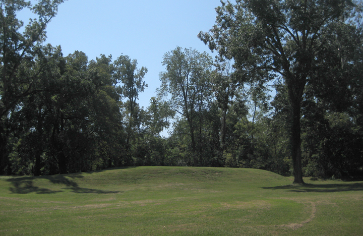
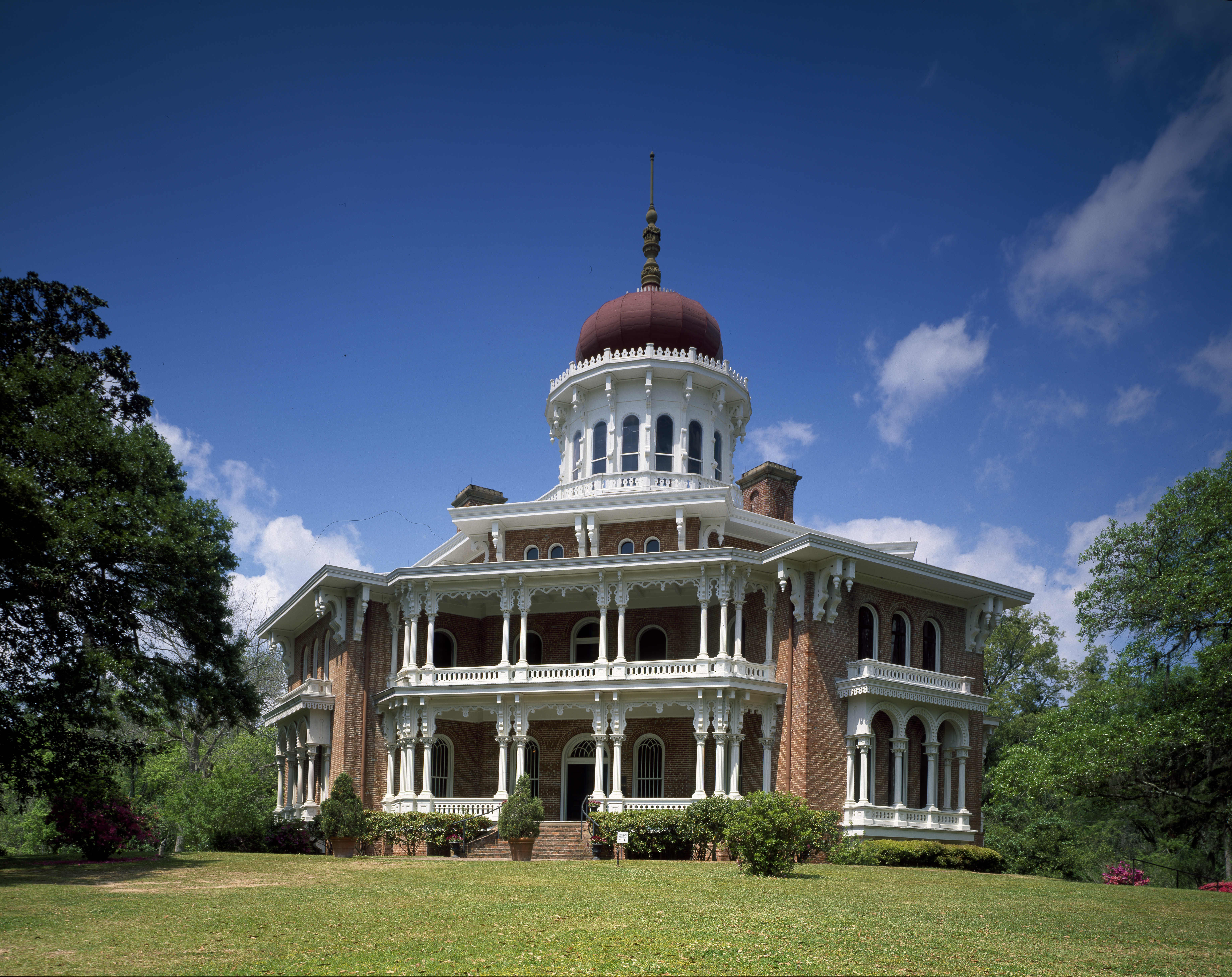
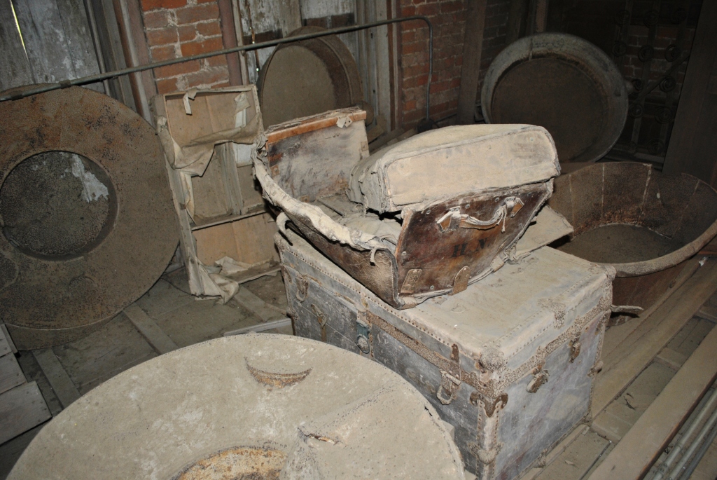
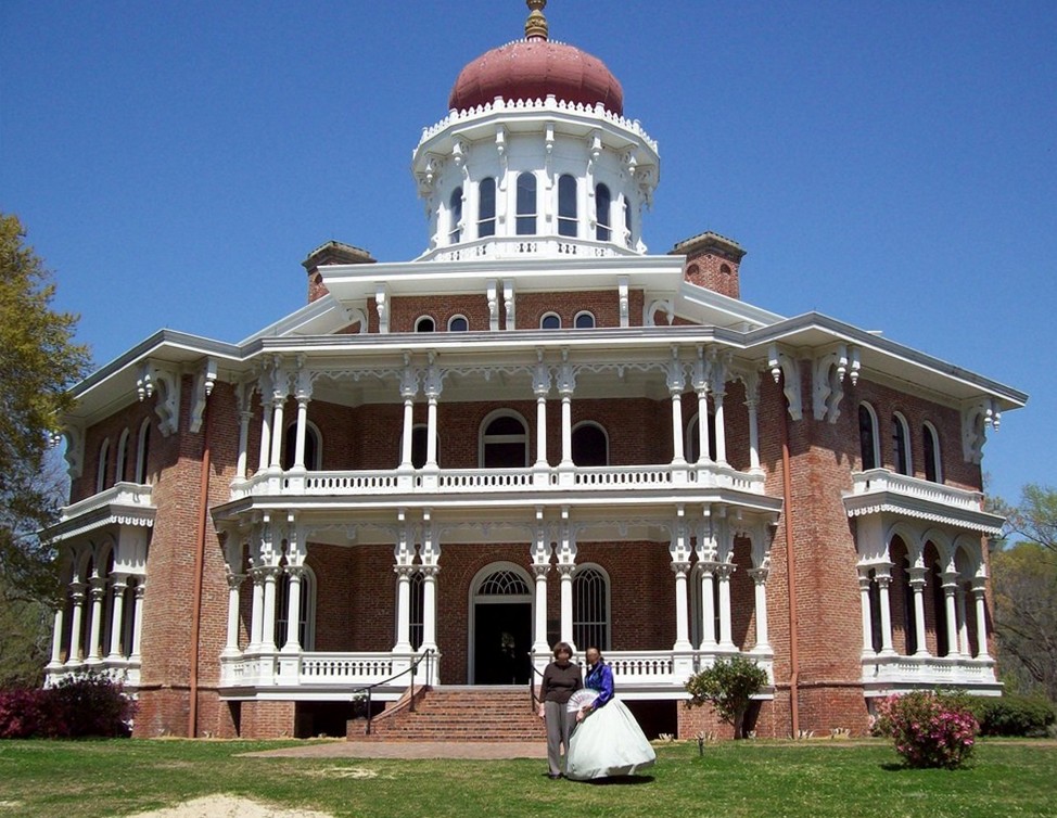
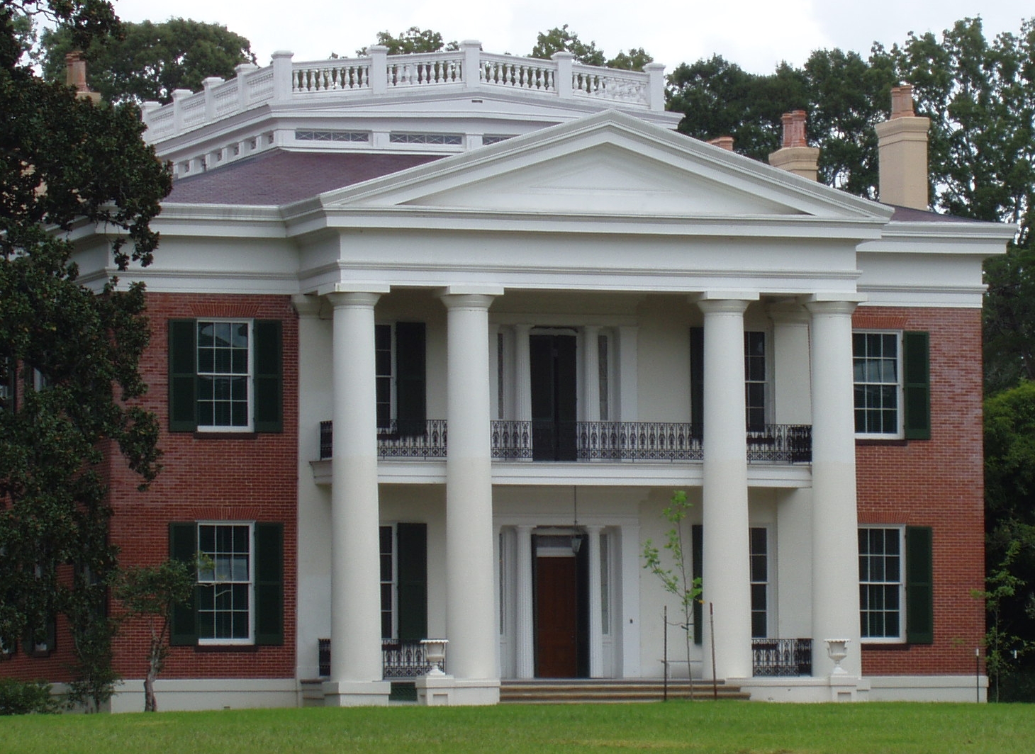
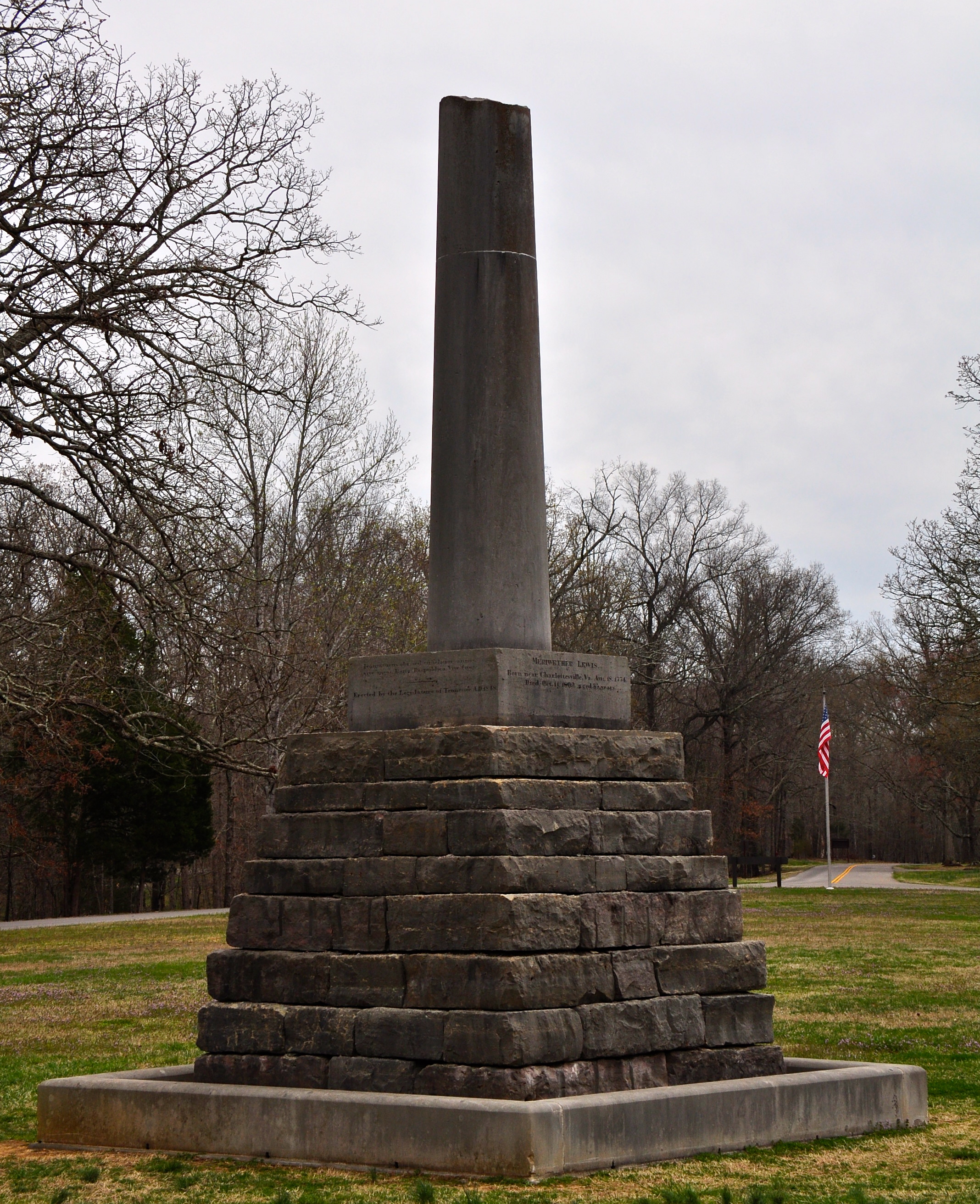
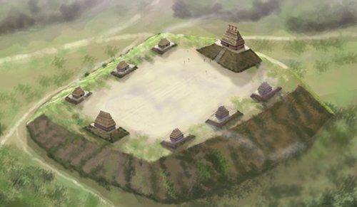
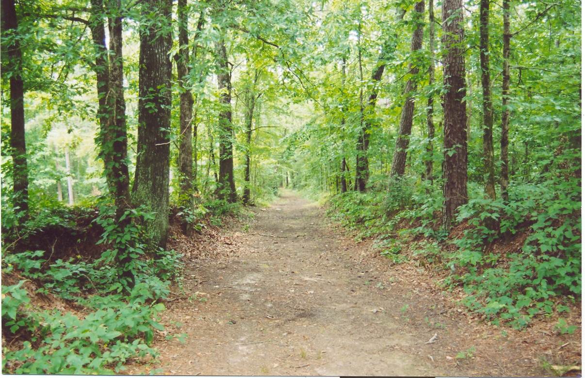
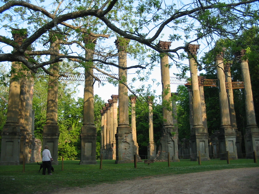
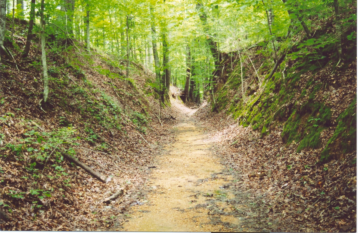