|
Reflections 2015
Series 7
April 30
Mississippi River III: Vicksburg – Oxford & Ole Miss – Memphis
| | The Approach We've been coming up the Natchez Trace Parkway, and decided that after Rocky Springs, there wasn't enough that was new and different towards Jackson and beyond, and it was time to cut over to Vicksburg, anyway. It was to be nothing more than a utilitarian move between points A and B, but I'd never imagined it would be so interesting. We had to dodge both the advancing Union Army and retreating Confederate Army, to try to get across the bridge and safely into Vicksburg before the Siege began. | | | | Well, no, wait, that must all in our imagination. Once again, one has to travel with both a modern and a historical map in one's mind of the area being traversed, at least if one wants to get the maximum out of the experience. We'll describe the experience twice, once for now in the present, and later again in 1863. Copy and paste the Map 1 we'd been using;
http://www.nps.gov/natr/planyourvisit/upload/NATRmap_1_113_web.pdf
| | | | Remember to tilt your head to the left to see what direction we're actually going in. Leaving Rocky Springs, Google had told us to take one easy route all the way, but that actually traversed three roads, Fisher Ferry Road, merging onto Halls Ferry Road, becoming Cherry Street in Vicksburg. We realize in advance we're going on old country roads, but don't yet realize how delightful that is. To visualize what we're doing—traversing in modern times old country roads, we have to do three things. | | | | First, eliminate any Interstate highways. They are so "late 20C & 21C". When we leave Vicksburg, we'll take I-20 to a bit of the Natchez Trace Parkway to I-55, but that's for later. Second, eliminate any US highways or county roads. They're so "early 20C". They were largely formed at the beginning of the automobile age in the 1920's by cobbling together bits and pieces of some of the very country roads we're about to experience, so erase our old friend US 61 and many numbered county highways, sticking to named roads. Now we're down to the nitty gritty, riding on some of the other original country roads that weren't sucked into numbered highways. These were the roads that you'd take even long distance in the late 19C. | | | | On our map, we see roads coming out of Utica. I've compared this to the 1863 military map in advance, and as far as I can tell, our second road, Halls Ferry Road, came out of Utica and has had some of its beginning compromised into Route 27, but then swings over right into Vicksburg. but is not shown. Our first road, Fisher Ferry Road, is probably the unnumbered road you see, which later merges into Halls to enter the city. One more thing. Find the thin blue line starting at the top of the map that's called Big Black River. You'll see it crosses ALL roads leading to Vicksburg, and is the basis for the roads whose names include "Ferry" although all those ferries are long gone, replaced by bridges, and we'll sail right across. Here's what the Big Black River (Map by Kmusser), with its watershed, looks like within the state. We're all set. | | | | We get off at Fisher Ferry Road and turn left under the Parkway in roughly a northwest direction. We find a pleasant, modern country road through forest and fields. But right at the beginning, we find we're crossing our old friend, Old Port Gibson road, the one in Rocky Springs that the church was on. We fail to note that significance at this point, although we do note a lot of historic markers, a skirmish here, a confrontation there. We hardly notice the Big Black River as we zoom across its bridge, but at a later intersection, we see a building or two on each corner, which looks so "country". | | | | Shortly, we blend together with Halls Ferry Road, and continue into town. But then, before we get to the 19C center of town, we run the gamut of the 20C automobile age, as strip malls and gas stations start appearing on old Halls Ferry Road. We last talked about this when taking the bus from the rail station into Ottawa—the car-based and car-dependent neighborhoods on the outskirts, with plenty of parking, then the older pedestrian-oriented area in the center, with parking more difficult. This differentiation is common, but there's one thing in Vicksburg that's quite different. Between the surrounding 20C area and the 19C center, there's parkland. Why should that be? That's because, like rings in a tree trunk, old Vicksburg had a "ring" around it before the 20C. The parkland is where the Siege of Vicksburg took place in 1863. | | | | So Halls Ferry Road passes it all: 20C, parkland, 19C, and the name has changed to Cherry Street. The best contemporary map of Vicksburg I could find was this:
http://www.roadtripusa.com/maps/greatriver/062_Vicksburg.gif
| | | | It's much more simplified that the corresponding Natchez map was, but we see the basic grid of the older part of town. There are more streets in between the named ones (including Cherry Street), and more almost-grid streets to the south, indicative of the direction in which the town first expanded, but this will do. We begin to really be amazed that Halls Ferry Road really was an authentic 19C entry into town before modern highways. We pass the strip malls, burger joints, and big-box stores so indicative of the 20C-21C before and after I-20, then the park area where the Siege took place, and are then in town, where we still can experience the 19C architecture and ambience. | | | | As we see, it's easy to read the history of a city just by looking at the map. Now just concentrate on that grid of the oldest part of town. It's about a dozen streets wide, and eight high. Halls Ferry Road has now become Cherry Street, and we get all the way to 1st East Street (name incomplete here). We turn right merely a half-block, and we're at the b&b, Anchuca. What seemed like long-distance, disparate routes have actually led us door-to-door. | | | | | | From the beginning, I was able to find the address, but couldn't understand it, since is the only street here with a number. And how is a street in the north part of town east of something? Only now, as I study the map more, I find that on the east side of town, the next street is 1st North Street, and it goes up to 5th North Street. What are they north of? It looks like some expansion system for street names that never really got off the ground. The directional words are confusing, and so was "my" street being the only numbered one in this area. But anyway, Anchuca Historic Mansion and Inn is located at 1010 First East Street, so we'd better get used to that unusual address. |
| | | | Anchuca I shall not discuss hotels, which are a world of their own. A very few well-known ones are destinations themselves, such as the Menger in San Antonio. Most of them, nice as they may be, are worth it to me because of their location, such as in Dallas. But Bed and Breakfasts being, or having been, private homes, have a domestic personality and tranquility that are unequaled. I find that there is also where I meet interesting people, such as the charming young man who owned the b&b in St John's, Newfoundland, or the Cajun newlyweds at breakfast in Natchez. | | | | But I must augment my paean to b&bs by commenting on their variety, from simple to over-the-top. This is not a criticism, since I don't recall ever being in a b&b that I didn't like—they all have their qualities. There are the simple and rustic, like in Labrador or northern Newfoundland. Delightful. There was the simpler former middle-class house in Natchez. Cozy and pleasant. There was the Clockmaker's Inn in Windsor NS, which had been an ample wealthy dwelling with many lush public rooms. Beautiful. And then there are the b&bs-in-a-museum, of which I've stayed in three. Curiously, they're all on the lower Mississippi, in Louisiana and now in Mississippi. | | | | We just summarized in 2015/5 the 2008 visit to Plantation Alley where, in a couple of days, I visited seven plantation houses and stayed in two of them. Very enjoyable were the overnights in Nottoway and Madewood, where you could check in to your room only after 5 PM, when museum hours were over. Anchuca (Photo by Bennett-ne), here in Vicksburg, is a similar situation, although here I stayed in a somewhat more modest room, since the ones in the main house were either far too expensive, or unavailable. (Unfortunately, I couldn't find a picture without utility poles.) | | | | The Anchuca Historic Mansion & Inn dates from 1830. It had been built in the Federal style, but the two-story Greek Revival portico was added to the front of the house in 1847 to reflect newer tastes. It withstood the Siege of 1863, despite its proximity, right in the center of town, to both the river to the west and the Siege lines to the east. It was used as a hospital after the battle. Joseph Emory Davis, Jefferson Davis' much older (by 23 years) brother and mentor, lived in the house from 1868 until his death in 1870. Working from here, he was eventually successful in regaining control of his plantation, one of the finest on the river, the Hurricane Plantation, but continued to reside at Anchuca. His brother, Jefferson Davis, President of the Confederacy, made one of his last public addresses to the people of Vicksburg from the upstairs front balcony (see photo) in 1869. | | | | Anchuca differs from the other two in that they are plantation houses with surrounding estates, but Anchuca is a town house, with houses on three sides, so it's quite compact. The driveway is to its left, and goes uphill (you see the slope of the land in the picture) with a carriage house on its left, and you end up in a lovely shaded parking area. I checked in and went to my room in the carriage house, then gave myself a tour of the mansion. The public rooms are on the museum tour, while the upstairs bedrooms are for guests. As a guest, I went upstairs and saw those accommodations, and of course I went out the door at the end of the upstairs hall onto the famous Jefferson Davis balcony. That evening I had diner in the Anchuca Café restaurant attached to the back of the main building. Take a look at the Anchuca website:
http://www.anchucamansion.com/
| | | | The home page has a much better view of the façade, with the balcony. Click on "Main House Rooms" to see the museum-quality accommodations. See if you remember what "tester" means in the South, and try to find the room with the tester bed and the one with the half-tester bed. Click on "Carriage House Rooms"; first note the alternating pair of pictures of the carriage house and its long porch above the driveway, then move down to Kate's Room, where I stayed. Finally, click on "Video Tour". The first thing you see after the house is the Carriage House above the driveway. Later, tour the house, and find out what three ingredients the ceiling medallions are made of. | | | | Vicksburg We shall see that there was great destruction in Vicksburg during the Siege and that little remains of what had been, especially of the grand antebellum mansions, few of which have survived. Today, ironically, most of what there is to see in Vicksburg involves that very Siege. Unrelated landmarks that endured, such as Anchuca, nevertheless always relate their connection to the Siege and its aftermath, such as having been a hospital, and the connection with the Davis brothers. The Civil War and the Siege remain everywhere in Vicksburg today, over a century and half later. | | | | Still, there's a bit of framework that we can present leading up to 1863. In the 18C, as the French, Spanish, and English flip-flopped over the possession of the Mississippi valley, it was the Spanish, coming over from Spanish Luisiana [sic] who founded a military outpost in 1790 on these bluffs called Fuerte Nogales / Walnut Tree Fort. When the Americans took possession in 1798, they altered the name to Walnut Hills, but when the village was founded in 1811 and incorporated in 1825, it was named Vicksburg after Newitt Vick, a Methodist minister who'd established a mission on the site. Because of its location on the Mississippi (Photo by Shawn Lea), it grew rapidly as a center for culture, commerce (principally cotton), and agriculture. It was a railroad center with connections both east and west, making it a major supply route for the South, and so for the Confederacy. It was a major river port for steamboats. Of course, all this is precisely what made it a military target. When it fell, it was a turning point in the Civil War, since the Union had full control of the river, which cut the Confederacy in two. | | | | In the few decades before 1863, planters arrived and built antebellum mansions in Vicksburg as in Natchez, but, while Natchez promptly surrendered to approaching Union troops and retains many of its mansions, Vicksburg did not, and lost most of the ones it had. | | | | American Civil War It is in no way my intention to summarize the entire American Civil War, and I couldn't do it if I wanted to—I've never studied it in detail as a whole, but, like most people, I'm familiar with the names of its most famous battles and events. But at this moment, after a bit of research, I find I've learned to categorize the war by theaters. It being compartmentalized this way makes it easier for me to understand.
| | | | I never knew before that there were so many theaters of the American Civil War. Least known--and least significant--is the Pacific Coast Theater involving the states of California, Oregon, and Nevada, and the territories of Washington, Utah, and later Idaho. I believe any action in that area was a matter of keeping order against rebellions. For practical purposes, there were four theaters in the eastern half of the country, as shown in this map, from the Library of Congress Civil War Desk Reference:
https://books.google.com/books?id=7svFnyOLknUC&pg=PA238&lpg=PA238&dq=LOWER+SEABOARD+THEATER&source=bl&ots=ZK7jdmGFwf&sig=x0oldQBymxzxVCyWbWFRcxg_NLQ&hl=en&sa=X&ei=26oxVY-DEcG0sATRlIF4&ved=0CB0Q6AEwADgK#v=onepage&q=LOWER%20SEABOARD%20THEATER&f=false
| | | | The two best known, and probably most significant, are the Eastern and Western, but let's take them clockwise. We probably think of the Eastern Theater most frequently, since it surrounded the National Capital of Washington and the Confederate Capital of Richmond, and also encompassed Gettysburg, the first of a pair of major turning points in the war. This theater included Virginia, West Virginia, Maryland (with DC) and Pennsylvania. The Lower Seaboard Theater included actions occurring along the coastal areas—think blockades—beyond Virginia to Texas (unclear on the map, but remember Galveston), but also including the lower part of the Mississippi River in Louisiana. | | | | Beyond those two, the Mississippi River again provided a border between two more theaters. West of the river was the Trans-Mississippi Theater and included Missouri, Arkansas, inland western Louisiana, inland Texas, and Indian Territory (now Oklahoma). The Western Theater started out just including states between the Mississippi River and the Appalachian Mountains--Kentucky, Tennessee, Mississippi, inland eastern Louisiana, and Alabama--but as the war progressed into its last two years, operations expanded from here into inland Georgia and also into the inland Carolinas (unclear on the map). This theater included Vicksburg, the second of the pair of turning points in the war. Again stressing the importance of the Mississippi River and its Gulf Coast entrance, Louisiana found itself in three theaters: the coast and lower river in one, the larger inland western area in a second, and the smaller inland eastern area in a third. | | | | Now let's begin to get local here in this excellent overview of the Western Theater (Map by Hal Jespersen). Blue are the Union forces, red are the Confederate forces. A lot of famous activity was concentrated around Tennessee, including at Shiloh and Chattanooga from where Sherman went to Atlanta and executed his famous March to the Sea at Savannah (followed by the Carolinas), a bold, unprecedented move operating in enemy territory without supply lines. Where Vicksburg had cut the Confederacy in two, Sherman's march cut the eastern remainder in two again. | | | | | | My first Civil War site experience was at age 12 on the Chattanooga trip in 1952 (2004/22) my first cross-country trip ever. Visiting Lookout Mountain with its beautiful views, we saw the sites dating from the 1863 Battle of Lookout Mountain. My main memory is the numerous memorial monuments from the various states all around the battlefield park. Of course, we sought out the New York monument. |
| | | | But let's concentrate our interest in the map of the Western Theater to the less complicated Vicksburg Campaign. First, as an overview, note how Grant and his Union forces moved down the river from Memphis to Vicksburg, which is precisely what we'll do in a few days sailing on the American Queen. (!!!) Early attempts at capture were not successful, so they crossed the river south of Vicksburg, were joined by forces coming from the Gulf and New Orleans, moved on to Jackson, then fought their way to Vicksburg from the East. By some measures, the Western Theater was the most important theater of the war, since it involved a two-directional attempt to capture the Mississippi River sailing down from the north and up from the south. | | | | When comparing the theaters of war, most notably the Eastern versus the Western, consider this map showing Confederate territory losses by year. Union territory is in white, including some coastal enclaves in the South. Three kinds of cross-hatching show Confederate losses in 1862, 1863 (including Vicksburg), and 1864. Finally, the blue area was lost at surrender in 1865. The Eastern Theater that we always picture as so pivotal, only gained territory in Virginia and West Virginia. But the Western Theater sees huge territorial gains, and the cutting of the Confederacy in two by winning the Mississippi River is made perfectly clear here, as is the geographic significance of Sherman's (destructive) March to the Sea further splitting the Confederacy. A map like this teaches me more about this war without necessarily learning the details of many individual battles. | | | | Vicksburg Campaign Vicksburg's importance made it a target, but a difficult one. It sat on a river bluff some 60-90 m (200-300 ft) above the water—already hard enough to be targeted from below—but the bluff was, at the time, located at an extremely sharp hairpin bend in the Mississippi—you do remember all those meanders. Its location was the basis for its nicknames, the Gibraltar of the South, of the Confederacy, or of the Mississippi, nearly invulnerable to naval assault. | | | | Abraham Lincoln believed that taking this river fortress of a city was a key to winning the war. It was so strategically vital to the Confederates that Jefferson Davis said "Vicksburg is the nail head that holds the South's two halves together" because it blocked Union navigation down the Mississippi and was one of only two points (the other was Port Hudson, near Baton Rouge) that allowed communication with the states west of the river. The Confederates depended on these states extensively for horses, cattle, and reinforcements. It was so strategically positioned that it took generals Grant and Sherman more than a year of planning, attacking, fierce fighting, and even canal-digging, before they could besiege it over a period of 47 days and finally capture it in July of 1863. | | | | First a bit of local geography. There is a well-known, somewhat diamond-shaped alluvial plain in northwest Mississippi that has an unusual name, the Mississippi Delta (Map by Philg88). It should not be confused with the Mississippi River Delta, where the river empties into the Gulf. I cannot explain why this area is confusingly called a delta. Because of its very rich soil, it's historically an agriculturally rich, ethnically vibrant area lying almost exactly between Memphis and Vicksburg, and between the Mississippi and Yazoo Rivers. When you see the drainage area of the Yazoo River, you see it covers most of the southern half of the Delta, and drains right at Vicksburg. | | | | There were actually two operations in the Vicksburg Campaign. The unsuccessful earlier one, which we won't go into in detail, took place in the earlier, winter months, from December 1862 to March 1863. The initiatives advanced from Tennessee in the north as we can see (Union movements are in blue, Confederate movements in red) on this map of the first operation (Map by Hal Jespersen). One plan was to reach the Yazoo to get to Vicksburg, another to use the rail line, and there were several other, unsuccessful initiatives. The most curious one, but also unsuccessful, was Grant's Canal, which we'll indicate on the map coming up in a moment. | | | | It was the second operation, the one we saw on the map of the Western Theater that was not only successful, but that is considered Grant's greatest achievement of the war and that is taught as a classic campaign of military history. It was the initiative that looked like the figure 6. Since attacking Vicksburg from the north hadn't worked, the plan was to try to have Union gunboats and troop transport boats sail south on the river and run the gauntlet of the gun batteries at Vicksburg, all while Grant moved his men south on the Louisiana side of the river. Then the objective was to move around the south side and approach the city from the east, completing the figure 6. Amazingly, the ships did this successfully on April 16 with the loss of only one ship. | | | | The year being 1863, we don't have aerial photos of the famous dash. But we have something almost as good, a Currier & Ives lithograph showing an artist's conception of the event, something very common in the era. We discussed the fact in 2011/10 that Currier & Ives not only made prints depicting contemporary life, but also showing news events, such as the opening of the Brooklyn Bridge shown in that posting, and both types of prints were eagerly sought after by the public. And so, Currier & Ives, New York, will illustrate for us what it calls at the bottom "Admiral Porter's Fleet Running the Rebel Blockade of the Mississippi at Vicksburg, April 16th 1863." | | | | This lithograph is made public courtesy of the US Naval Academy Museum at Annapolis, so do realize that it's taken seriously. We are looking north, upstream, so the ships are coming toward us. Front to back are the (all USS) Benton, Lafayette and General Price, Louisville, Mound City, Pittsburgh, and Carondelet. They are followed by the troop transports Silver Wave, Forest Queen, Henry Clay, and Tuscumbia. The Benton is the flagship. They are all ironclad river gunboats, some purpose-built, some converted, like the Lafayette, which had been a side-wheel steamer. Interestingly, the General Price had been a Southern civilian ship, taken over by the Confederates, sunk in the Battle of Memphis, raised, repaired, renamed, and recycled here for the Union. | | | | Giving a contemporary news report, the hard-to-read text under the title says: "At half past ten PM the boats left their moorings & steamed down the river, the Benton, Admiral Porter, taking the lead--as they approached the point opposite the town, a terrible concentrated fire of the centre, upper and lower batteries, both water and bluff, was directed upon the channel, which here ran within one hundred yards of the shore. At the same moment innumerable floats of turpentine and other combustible materials were set ablaze. In the face of all this fire, the boats made their way with but little loss except the transport Henry Clay, which was set on fire & sunk." | | | | Before we see how interestingly events unfolded south of Vicksburg, I want us to look at a familiar friend, our old Map 1 above, which concentrates on the Natchez Trace Parkway. First find Grand Gulf, which was not a successful landing, but you see that there's apparently a monument there to it. Then find Bruinsburg, which is unnamed on the map, because it doesn't exist anymore, but it's the next black road south. Note how that road leads from the river to Windsor Ruins, Port Gibson, Rocky Springs, and beyond, and you'll have an idea of the adventure we're in for. And we'll do it with this even better map of Grant's Operations Against Vicksburg (Map by Hal Jespersen) between April and July, 1863. But I really think you should copy and paste it in a separate window to enjoy it to the fullest as we discuss it:
http://upload.wikimedia.org/wikipedia/commons/3/3c/VicksburgCampaignAprilJuly63.png
| | | | Note how, having come down from Memphis, the bottom part of our figure 6 loops around, and now looks more like a triangle, one where the blue Union lines are much more active than the Confederate red ones. Let's start at Vicksburg (click). We can now quickly take a look, with more explanation later, of one of those unsuccessful events mentioned above, Grant's Canal. It seemed to make perfect sense. That long, thin DeSoto Peninsula, ending in DeSoto Point, is what formed that huge, sharp bend in the river that forced river traffic under the bluffs of the city, making it the Gibraltar of the Mississippi. What if a canal were cut through the peninsula, cutting off the bend? If ships could use such a canal, the guns of Vicksburg would be useless. But it was a total failure and was never finished; we'll give details on it when we visit it later. | | | | Now back to where the ships, lacking any shortcut canal, just ran the gun batteries in Vicksburg on April 16, and then of course, we'll end up back in Vicksburg with the Siege. We see three Union armies marching down the Louisiana side and note all the meanders and oxbows in the river. On April 29, using Hard Times Plantation on the Louisiana side as a staging area, the ironclads attacked Grand Gulf, but the Confederates held them off, and prevented the Union infantry from landing. But it was a minor victory for the Confederates, and only altered Grant's plans slightly. | | | | | | Grand Gulf had been a river port, and had transshipped thousands of bales of cotton from its rail line to the river. But years later, the Mississippi shifted its course to the west (the River is such a false friend!), and the town became isolated and died without its river access. By the turn of the 20C it was a ghost town. The little that remains now forms Grand Gulf Military State Park. |
| | | | Later the same day, Grant arrived at Disharoon's Plantation on the Louisiana side. It was protected by a high natural levee, which served as an excellent steamboat landing, marked as Disharoon's Landing (misspelled) on our map. Grant planned using this as a staging area to land his troops at Rodney (see map). But an escaped slave told Grant about the much nearer port of Bruinsburg, which had an excellent steamboat landing, and a good road ascending the bluffs east of the river. The same day and the next, April 30, the ironclad ships crossed the river and landed 17,000 Union soldiers at Bruinsburg Landing. Because it was wartime, there was no traffic and the port was nearly deserted, and had room or many boats. The landing at Bruinsburg was the largest amphibious operation in American military history until the Allied invasion of Normandy. The soldiers moved inland and rested under the trees at Windsor Plantation, where apparently that soldier sketched the building left the only visual record of it, as we discussed when we were there. | | | | | | By 1865, Bruinsburg, with Bruinsburg Landing on the river, was a ghost town. It had been an important commercial and military location, and nothing remains today. The area is private property. And such an important landing had taken place here! Sic transit. |
| | | | We started this posting approaching Vicksburg with a modern map. We are now ready to fantasize the same thing, a virtual 1863 approach, using a period map. It is nothing more than dumb luck that we stumbled across what turned out to be such a historic area, just because we were looking to cut across from the Parkway to Vicksburg. But I will admit, that I was unaware of most of these details at the time, beyond the occasional mention at Windsor and other places of Union soldiers. | | | | Windsor Ruins is about halfway between the former Bruinsburg and Port Gibson, so we start out our virtual experience following the Union advance. At Port Gibson, we got back on the Parkway and Trace to beyond Rocky Springs, but there we found Old Port Gibson Road at that Methodist Church. NOW it's clear that the Union forces had marched up that parallel road right past us at the church, and would continue on it. | | | | But one thing stands out as an important difference, the Big Black River. We sailed right across it on a small bridge, hardly noticing it, but in 1863, it's a major impediment! Follow the length of the map, and you'll see four ferry crossings, and one bridge. And the first ferry we see enters into military strategy. Confederate General Bowen had evacuated Grand Gulf and moved as quickly as he could to Hankinson's Ferry, barely crossing over before the Union Army got there, and rushing into Vicksburg. It was also Grant's intention to use this ferry and the same route into the city, which would seem to be the most logical route. But scouting parties he'd sent ahead reported that there were good defensive positions to the south of the city, so Grant changed his plans. He would now continue to Jackson, and attached the rail and road supply routes coming in to Vicksburg. | | | | Well, that's good for Grant, but where does that leave us? Just beyond Rocky Springs, we see what we know as Fisher Ferry Road exiting Utica and crossing Old Port Gibson Road, as we saw earlier. But as we continue northwest, we have a surprise! There's no Fisher Ferry because this road doesn't continue on the other side to merge with Halls Ferry Road! Both the ferry and name of the road must date from after 1863. So instead we backtrack a bit to Old Port Gibson Road and spot where we can get on Halls Ferry Road out of Utica a little early. Maybe we can still get into Vicksburg before the Siege starts. | | | | While we'll note that Pemberton was the Confederate general connected with Vicksburg, the other one of note here is Johnston, who was actually the overall theater commander. So the more compete reason Grant altered his route was to confront each of two Confederate armies in turn, and also cut the line of communication and reinforcement between them. | | | | And, including Port Gibson, Grant won five battles before the Siege, including taking Jackson, the capital of Mississippi. The last battle brings us back to the Big Black and its bridges, and seeing what importance this little river had, mostly as an impediment. The retreating Confederates tried to hold on to the railroad bridge, and the steamboat dock, which crossed the Big Black and apparently served as a bridge (yes, the Big Black even had steamboats!). But as the Confederates retreated, they set fire to both bridges, hoping to slow down the Union armies. Yet the Confederates were disorganized, and the Union forces captured about 1700-1800 troops, and many drowned (!!), troops which the Confederates could hardly afford to lose. Fewer than half the Confederates who had fought at the previous battle at Champion Hill, made it back to defend Vicksburg. The Battle of Big Black River Bridge sealed Vicksburg's fate—the Confederates would now be bottled up at Vicksburg. | | | | The Siege of Vicksburg The Union army reached Vicksburg, trapping Pemberton's forces and the civilian population. Grant tried two assaults to break through, both unsuccessful, so Grant started the Siege. Federal troops ringed the city facing the Confederates on their inner ring. On the other side, Union gunboats also fired on the city. Pemberton was hoping for relief from Johnston, but it never came. | | | | Keep the Grant's Operations map we've been using in reserve, and now let's look at the map of the Siege of Vicksburg (Map by Hal Jespersen). Look again at that sharp bend around the peninsula. From the waters here, there was naval bombardment of the city. The railroad cut across from the east, which had presumably allowed for transshipment to and from the railroad on the peninsula up until now. And bold as can be, Halls Ferry Road enters from the south. I hope we all scurried into town before hostilities started. Curiously, the battle area is shaped like an ear, with the red Confederate ring defending, and the blue Union ring attacking. | | | | After the two attacks, there was carnage. The dead and wounded of the Union side lay in the heat. The odor of the dead men and horses fouled the air, and the wounded cried for medical help and water. So a temporary truce was declared. The Confederates held their fire while the Union recovered their wounded and dead, and soldiers from both sides mingled as if they weren't in the middle of a war. And then the truce ended. | | | | But Grant had a problem. He couldn't easily man the full encirclement of the city, even with 50,000 soldiers. While it was unlikely that the Confederates could escape, there were nevertheless roads leading south out of the city that were unguarded by Federal troops. "Our" Halls Ferry Road certainly was one of them. Go back now to the Grant's Operations map and note how that map at least shows a concentration of Union effort to the northeast and east, and little to the south. That situation still reflects today as to where the Military Park is located. | | | | Both the soldiers and civilians in Vicksburg suffered from the bombardment and impending starvation. Their only hope was that General Johnston would arrive with reinforcements, but not only was Johnston cut off, he was also too cautious to do anything. The soldiers were worse off because of the poor diet. The Siege lasted 47 days, just under seven weeks, and by the last week, half were out sick or hospitalized with scurvy, malaria, dysentery, diarrhea, and more. At least one civilian stayed up at night guarding his vegetable garden from starving soldiers. Over time, horses, mules, and dogs started disappearing. For many, shoe leather was a last resort. | | | | The shelling was constant. During the Siege, Union gunboats shot over 22,000 shells into the town, and there was even heavier army artillery fire. Houses of all sort, not only the mansions, were destroyed. To the east of town, on the way to the Confederate lines, the citizenry dug into the yellow clay hills and hollowed out over 500 caves. (I had read about that earlier, but it later struck me, could that be the loess that caused the Sunken Trace? If loess compresses easily, it would be easy to dig out, and the illustration I was able to show was of loess bluffs in Vicksburg.) | | | | Many moved into caves because of the loss of housing, but others did so because the caves acted as bomb shelters. I know the owners of the Duff Green Mansion, today still standing as a b&b in the next block from Anchuca, nevertheless had abandoned it for the safety of living in caves. The caves became comfortable underground homes that included rugs, furniture, and pictures. Still, with all the firing on the town, fewer than a dozen civilians were killed during the Siege. And for those that are reminded of the London Blitz, with civilians taking refuge in the London Underground, consider again how little there is little that's totally new in history. | | | | With Johnston offering no help, everything fell on Pemberton's shoulders, and especially noting the suffering of his soldiers, on 3 July, he sent a note to Grant. Finally, Pemberton surrendered the city and his army on 4 July, US Independence Day, and the Confederate flag came down over Vicksburg, and the American flag rose. As with that earlier temporary truce where the Confederates held their fire, after the surrender, the Union troops behaved well. They mixed with the Confederates and offered rations to starving soldiers. People who had speculatively been hoarding food waiting for higher prices had their supplies broken open and the food thrown out onto the streets for the starving Confederates. Grant noted the fraternization of the two armies as though they had been on the same side. Makes you think. | | | | At first, Grant had wanted unconditional surrender, but then rethought the situation. He didn't want to have to feed an entire army of 29,495 hungry Confederates in Union prison camps, nor have to ship them to camps, so he offered to parole all prisoners. Considering the state they were in, he never thought they'd fight again, and also thought they would spread the misery of defeat around the Confederacy. But in actuality, most of the men paroled after the surrender were received back into the Confederate army a month later, and fought at Chattanooga and in Georgia. Nevertheless, Grant also captured quite a bit of munitions. | | | | In the Siege, the Confederate killed and wounded came to 2,872 and Union 4,910, which is relatively small, compared the totals of this entire second operation of the Vicksburg campaign, which had Confederate casualties at 9,091 and Union 10,142. With this total of about 20,000 casualties, this was the largest and most complex campaign in the entire American Civil War. Coupled with the Confederate loss at Gettysburg on 3 July, the very day before, these two battles are considered to be the turning point of the war. The Confederacy was split in two, the Mississippi was in Union hands. One week after the surrender, an unarmed ship blissfully sailed uneventfully from St Louis to New Orleans, as though nothing had ever happened. | | | | After the Civil War, the North and West grew rich while the once-rich South became poor for a century, but then that wealth had been heavily dependent on an unpaid labor force. Based on 1860 census figures, about 8% of all white males aged 13 to 43 died in the war, including 6% from the North and 18% from the South, establishing the American Civil War as the deadliest war in American history. | | | | Visiting Vicksburg Let's now put aside our virtual 1863 arrival into Vicksburg and consider the present day one. We have one full day to see the sights, and it's best to do it in a clockwise manner. Let's start with this simplified current map (copy and paste):
http://www.nps.gov/vick/planyourvisit/images/ctymapn_2.gif
| | | | The first thing we see is that the former Gibraltar of the Mississippi is no longer on the Mississippi! Where that sharp loop had been is now a lake on the left and the rather sterile Yazoo Diversion Canal on the right, along the bluffs. (If you check the earlier, simple modern map, you'll see that the lake is called Centennial Lake, and is sort of an oxbow lake attached to the canal.) The River today barely touches the bottom of the southern suburbs. We'll explain what happened when we get to Grant's Canal. We see Halls Ferry Road becoming Cherry Street, with Clay Street going out to the Military Park. We'll also visit Cedar Hill Cemetery later. But we can use this map to finally explain something at bothered me from the beginning, and may have occurred to readers as well. What happened to the rest of the Military Park? While most of our ear-shape is still discernable, the Park only covers a limited amount. Well, further post-trip digging explains it, and our review of the Siege explains it further. | | | | In the late 1950s, that southern part of the Military Park was transferred to the city to be a local city park. This was done in exchange for the city closing some local roads that ran through what was then the main part of the park, now truncated. Whatever state monuments that were in the transferred area are still maintained by the National Park Service. It still seemed confusing until we just noted that the southern part of the city was never a main battle area, and was even lightly blocked by Union forces. It seems it was the area in the east that was closest to the grid of the city that saw most of the action, and therefore it really is quite appropriate to have made the change—as long as its location is still indicated, which it is. | | | | But the best thing to use as our map is the very one the NPS hands out to Park visitors. Copy and paste:
http://www.nps.gov/vick/planyourvisit/images/full_map_2.jpg
| | | | You can read some of the text if you like, but we'll just follow the map. We'll leave Anchuca at Cherry, just two blocks north of Jackson, and on reaching Jackson at Cherry, we'll stop at the Old Court House Museum (Photo by OzarksRazorback). The former Warren County Courthouse is a dignified building with a separate portico for each of four directions. The low structures on each of four corners were originally used as cisterns. (The two on the front that you see are today public rest rooms!) The building was closed in 1939 when the courts moved to another building, and today contains a Civil War Museum, obviously pertaining principally to Vicksburg and the Siege. When the city was founded, an entire city block had been designated for a court house, and the present one was built in 1858, just five years before the Siege. Jefferson Davis was a local planter, and he started his law career in this courthouse. | | | | This is an engraving of Vicksburg in 1855 published in a Boston Magazine that year. First of all, you can see Vicksburg when it was still actually on the Mississippi, including what would be Vicksburg Landing being visited by numerous steamboats. But you can also see how prominently the domed courthouse sits on its hill. Given the dates, this would likely be showing the previous courthouse, but it's obvious that either that one or the later building could be easily seen from the river to the west, and, during the Siege, could also be seen from the battlefield to the east, so the building was within artillery range from both sides. Although it was a repeated target, it only suffered one direct hit. Also, during the Siege, the Confederate flag, a symbol of resistance, was visible on top of the courthouse throughout. This is where the flags changed on 4 July 1863. Copy and paste this link:
http://pictures-civil-war.com/gallerys/vicksburg/leslies-battles-commanders_vicksburg_surrender_.jpg
| | | | Click to see an artist's impression from Harper's Weekly showing Grant taking possession of Vicksburg after the surrender, including the unfurling of the American flag on the court house. Three of the four cisterns are visible here. | | | | Although we'll want to be turning left onto Clay Street to the Park, we first have to go just two blocks south beyond it and instead turn left onto Crawford Street, to see the most poignant sight in town, Balfour House (Photo by Berberry). At first it might just seem like an 1835 antebellum mansion that survived the war, which it is. It was the home of Emma Balfour, who later became famous as being the diarist of the Siege, and for the fact that she famously refused to leave the house during the bombardments, and used the house to shelter wounded Confederate soldiers. But Balfour House is known best as the site of the fateful 1862 Christmas Ball. | | | | It was Christmas Eve 1862, when the Balfours hosted a grand Christmas Ball. The war had not yet come close, and life continued as it always had. Among the guests were many Confederate officers and their ladies. Meanwhile, across the river in Louisiana, the telegraph office got an extremely urgent message from Lake Providence, Louisiana, about 58 km (36 mi) north. The telegraph operator who took the message knew it had to be delivered immediately to General Smith who was attending the Ball, despite the fact that it was cold and stormy out, that the river was churning and dangerous, and that only a small boat was available. Just after midnight, the telegraph operator, exhausted and covered in mud, burst into Balfour House and strode through the crowd of dancers, who stood aside. He saw General Smith and went right up to him with the message. At that point, Smith announced to all that the Ball was over, and that the enemy, the Federal Fleet, was coming down the river. The men had only moments to say goodbye and to report to duty. It was already Christmas, and the next day, 26 December, the first battle of the earlier operation of the Vicksburg Campaign took place. After the other end of that Campaign on 4 July, the old life was well on its way to being over, and it was ironically Balfour House that was commandeered as the Union headquarters, just as Rosalie had been in Natchez. Ironic as this is, you just can't make this stuff up. | | | | The Christmas Ball is commemorated by this historic marker (Photo by Berberry) in front of the house. The events that took place here should certainly remind one of the beginning of Gone With the Wind, where a lavish party is taking place and the men are enthusiastically taking about impending war, not knowing what was in store. | | | | But that's not quite the end of it. With only their gardens separating them, the next house down the street, on the same side, is the house that had served as Pemberton's Headquarters (Photo by Infrogmation). It's of the same date, and also survived the Siege. Here Pemberton made the decision to surrender the city on 3 July. | | | | Now we go back to Clay Street and in moments are crossing the former battlefield, as we turn into the Visitor Center of the Vicksburg National Military Park. I still have that lifelong National Park Senior pass that I got in 2007 when visiting Mesa Verde National Park (2007/14). Everyone else is on his/her own! | | | | There's a movie and some displays, but then it's off one goes in one's own car. Now one thing I have to say is that this is the most easily understood battlefield I've seen. Beverly and I visited Waterloo (on rented bikes) south of Brussels, we saw Yorktown VA, where Cornwallis surrendered to Washington, we saw Gettysburg PA. In so many of these cases, I found it hard to follow the battle. Who was where? Who charged? Who advanced? Who retreated? Sure, you can figure it out, but to the casual visitor, it's usually hard to tell. Not so with Vicksburg. Look at the map. The Union forces were lined up on what is now named Union Avenue, with historic markers in blue. The Confederate forces were lined up on what is now named Confederate Avenue, with historic markers in red. It couldn't be clearer. | | | | The 26 km (16 mi) self-drive tour route runs counterclockwise on the main area, so you see the Union side first. South of the tracks, it's the reverse. As with all battlefield parks, of course you really see nothing of the chaos that actually went on, mostly grassy expanses and perhaps some cannon and many memorials. But there are 32 km (20 mi) of historic trenches and earthworks, and 144 cannons. Mostly, though, it seems you see the 1,325 historic state monuments and memorials, most (not all) of which were put up in the first decade of the 20C, after the Park's founding in 1899. Massachusetts was first with a memorial, in 1903. Some states have only one or two, others have many. Typical is this Wisconsin Monument. Some are larger, and in the form of obelisks or columns, such as the New York Monument (copy and paste):
http://npplan.com/wp-content/uploads/2014/11/Vicksburg-040.jpg
| | | | One can't miss the seemingly dozens and dozens of Illinois monuments, in addition to which is what is surely the largest state memorial in the Park, which is in the form of an entire building, the principal Illinois State Memorial (Photo by Katyrw). It was modeled in part after the Pantheon in Rome, and has 47 steps, one for each day of the Siege. | | | | I've heard two conflicting stories about the monuments, so I'll present them both. One was that the still wealthy North built its memorials promptly, while the South, impoverished after the war, had to delay putting up its memorials to a point later in time that than the others. The other story is that the Federal Government, having financed the Park, also financed memorials for the Union states. The former Confederate states, however, received no such Federal funding and had to go through years of fund raising to built its monuments. While the logic is clear, it does seem unfair, since the period of putting up monuments was four decades after the war in a reunited Union. | | | | Today everything consists of beautiful, manicured lawns (Photo by Fredlyfish4) where once there had been a no man's land. Actually, once the Park was founded in 1899, the lines on both sides were marked during the next decade by many of the veterans who fought at Vicksburg, so this Military Park is one of the most accurately marked ones in the world. Perhaps you should put this picture in a separate window to follow the description below:
http://upload.wikimedia.org/wikipedia/commons/2/23/Vicksburg_NMP_2014_1.JPG
| | | | This view can be representative of all wide-angle views in the park. I've done some research to identify what we're looking at that I didn't recognize at first. On our map, find, at the beginning of our drive, the Minnesota Monument. It's not in the picture, but this is approximately where the picture was taken. Then locate 1) the Louisiana Monument on the other side, 2) the Illinois monument, and 3) the Shirley House. Now go back to the picture, click to enlarge and pan from the left. First you see a bit of Confederate Avenue, then the tall column of 1) the Louisiana Monument. In the center, in front of what I think is the old Park headquarters, is an area being restored, where the NPS wants to clear away some of the vegetation that has grown up in the century and a half since the Siege. Next there are numerous small state monuments on the horizon, the huge 2) Illinois Monument (Pantheon), the 3) Shirley House, and Union Avenue with more state monuments, and some Union cannon. | | | | Just because the battlefield was in the open countryside, doesn't mean there weren't houses there, and the Shirley House is the only survivor. As a matter of fact, it's the only surviving wartime structure of any kind, and it's been restored to how it looked in 1863 before the war. It was owned by James and Adeline Shirley, and was famously referred to by Union soldiers as the "white house" during the Siege. You'll recall that Grant tried two unsuccessful assaults before the Siege, on 19 and 22 May. On 18 May, as the Confederates were establishing their defenses, soldiers were sent out to burn all houses between the two sides. The Shirley barns and outbuildings were quickly burned to the ground, but the soldier assigned to burn the house was shot before he could do so. When the fighting started, Mrs Shirley, her 15-year-old son Quincy, and several servants were caught in the cross-fire. Terrified, they stayed huddled in a chimney corner for three days, at which point Mrs Shirley tied a sheet to a broom handle and placed it on the upper front porch. Union soldiers finally removed the occupants and given shelter—where else, but in a cave. | | | | This is the Shirley House in 1863. Note the upper front porch, and the Union trenches. Today, the Illinois "Pantheon" is straight ahead, just down the road, and this is the restored Shirley House--with its upper front porch (Photo by CalvertBrown). | | | | We're choosing just the most interesting locations as we continue our drive past the northeast corner of the Park—note the locations of the Wisconsin and New York monuments we saw before—and we swing around to the northwest section for two stops, the USS Cairo Museum and the Vicksburg National Cemetery. | | | | The Park also commemorates the naval activities that took place on the other side of Vicksburg, particularly in the USS Cairo Museum. Think back to the unusual-looking, ironclad Union gunboats we saw in the Currier & Ives lithograph earlier, and then take a look at a period photo of the USS Cairo, named after the city at the confluence of the Ohio and the Mississippi, and taken on or near the Mississippi in 1862. The ship was in service for only eleven months before it made history as the first US marine vessel to be sunk by an electronically detonated naval mine. It happened on 12 December, nearby, on the Yazoo, a river important during the war, and in the same year as the picture. The Cairo was on duty clearing mines from the Yazoo when one was detonated by Confederate volunteers hidden on the river bank. She sank in 12 minutes, but with no casualties. | | | | The gunboat was forgotten over the years as she was covered by silt and sand, which actually had the affect of preserving it, as well as the artifacts on board. But its crew had died off, and locals over the years became unsure of just where she was located. Then, a representative of the Park studied old maps, and set out to search for her, using metal detectors—what better to find an ironclad. It was found in 1956; in 1960, numerous artifacts were recovered, and in 1964, the last section was raised (there are 29 other sunken ships from the Civil War period in the Yazoo). State and local funds were used to establish the USS Cairo Museum in a part of the Park closest to the Yazoo and to where the Mississippi had been in 1863 (see map). | | | | I can only recall having seen one other salvaged ship, the 1628 Vasa in Stockholm (2006/8). The first time I saw it, it was shown in the preservation studio, where it was being kept moist by water being sprayed on it. Years later, in 2006, it had been installed in a beautiful building. But unfortunately, the Cairo remains outdoors, although under a tent-type roof. It has to have suffered degradation because of this. I understand that she is one of only four surviving Civil War-era ironclads in existence, and the Cairo is the only one outdoors. | | | | This (click) is the USS Cairo (Photo by Fredlyfish4) today under its roof. Artifacts are kept in the brick part of the museum to the right, set into the hillside. Here is a closeup of the bow (Photo by Wilson44691), and this is her port side (Photo by Fredlyfish4), closest to the museum. You can see how she's been partially restored, with the wooden framework that's been built to show the skeleton of what's missing, and to support what remains of the ship. Click to see the visitors inspecting the interior. The Cairo, and all the others, were paddlewheel steamboats. She was fired by five steam boilers, which, as I read on site, were always kept running. While that sounds surprising, just imagine the impossibility of firing up a boiler to get moving when under attack. Finally, this is a view of her starboard side (Photo by RiverviewClock) showing the iron cladding and one of the cannons. Now as said, these were paddlewheel steamboats, and, as a matter of fact, had two narrow side-by-side paddlewheels. Look in the background, and you'll see the remaining framework of both wheels.
| | | | Immediately following is the Vicksburg National Cemetery, which holds the remains of over 18,000 Civil War Union soldiers (Photo by NatalieMaynor), a number unmatched by any other National Cemetery. Here, 75% of the interments are listed as unknowns, while at military cemeteries nationwide, the percentage is 54%. About 1,300 dead of subsequent wars up to WWII are also buried here. We'll see in a moment where Confederate burials are, but it's interesting to note that, in the late 1860s, two Confederates were mistakenly buried here, one from Texas and one from Arkansas. There may be others. This is another view, with an Iowa state monument (Photo by Father of JGKlein). | | | | There follows an interesting street above the River called Connecting Avenue, allowing us to now enter Confederate Avenue, and now see Confederate monuments in place of the Union monuments we've been seeing. Just before that Louisiana monument we saw before from the other side, is an interesting road. I have to assume it was once a through street, but now it, too, connects just both roads within the Park. Turning left, in just a few seconds we come to an oak tree, only about a quarter of the way down the short road. Copy and paste:
http://www.civilwaralbum.com/vicksburg/2011a/surrender.jpg
| | | | We are at the Grant-Pemberton Surrender Interview Site. You can see the short distance down the road we've come off of Confederate Avenue—that Louisiana monument, the column, is in the background. Here is the oak tree (or perhaps a later replacement, but who really cares?) with an upturned cannon. Copy and paste:
http://www.civilwar.org/photos/galleries/vicksburg/images/surrender-intervew-site.jpg
| | | | This (in an autumn picture) is the upturned cannon marking the meeting spot and signifying the end of hostilities. Once again, there are no photos, but people relied much more in that era on artist's conceptions. We have two (copy and paste):
https://cwcrossroads.files.wordpress.com/2012/07/grant-pemberton-01.jpg
http://cdn.loc.gov/service/pnp/cph/3c30000/3c32000/3c32900/3c32939v.jpg
| | | | I find them both interesting. The first is by John Steeple Davis, a New York soldier of British origin who served in the war. It's a bit more formal, and shows the tree. The second one is again an artist's conception from Harper's Weekly. It's more casual, and just shows two soldiers talking. | | | | While others might turn around here and return directly to Confederate Avenue, we need to do something else first. We drive the other three-quarters of the way down this short road and arrive at Union Avenue, then make a U-turn and go back again across the one-time no man's land to Confederate Avenue. You can't let the opportunity pass you by of doing something today that would have gotten you shot at in 1863—from both sides. | | | | We come to the end of this loop and the road splits. To the left, those that want to wimp out can return to the Visitor's Center and leave. We, however, know there's more of interest, and turn right through the underpass beneath Clay Street and the rail route to the lower Park area. Immediately we connect present and past. What today is a railroad underpass, is next to what was in 1863 a rail line to be fought over. You can walk up the earthwork the Confederates built to protect the rail line, and which they fought Union troops over. | | | | We continue on the Confederate side first here but are again soon on the Union side. There's a small sign on the left reading "Kentucky Monument". Why should that be? No other state monuments have such signs. We park and walk down a path for 2-3 minutes and find something very interesting. A Kentucky monument, not on one or the other side, but right in the middle of the former no man's land, equidistant from both sides. (This older map says "future", but in fact, it was built in 2001.) It's quite unique (copy and paste both links—one is an overview, the other a detail):
http://www.civilwaralbum.com/vicksburg/monuments/ky1.jpg
http://2.bp.blogspot.com/-nF1PjjbPg-c/UTXsBRqS8JI/AAAAAAAA0gc/c0kBy4GE7x4/s1600/kentuckycu.jpg
| | | | It's different from every other monument, and was installed much later. It features a bronze statue of Abraham Lincoln on the left, the Union side, and one of Jefferson Davis on the right, the Confederate side. It's pointed out that both men served as presidents, in different ways, between 1861 and 1865. Furthermore, both were born in Kentucky (!!). Although Lincoln is most associated with Illinois, he was born in 1809 in Hodgenville, Kentucky (south of Louisville--I've been there) and Davis was born in 1808 in Fairview, Kentucky (about two hours' drive further SW). Kentucky was a border state, and Kentuckians fought on both sides, so there was an internal division in Kentucky as there was on this battlefield. The back wall has conciliatory quotes from both men. | | | | We now leave the Park (see map), backtrack on Clay Street, and turn up on Mission 66 Road to Sky View Avenue and enter Cedar Hill Cemetery (Vicksburg City Cemetery), through the special gate to the area called Soldiers' Rest. Originally, Confederate dead from the Vicksburg Campaign were buried behind the Confederate lines on the battlefield. When corresponding Union burials were transferred to the National Cemetery, a solution had to found for the Confederates, so a part of Cedar Hill Cemetery was set aside to be called Soldiers' Rest (copy and paste):
http://www.civilwaralbum.com/vicksburg/2002/csa_cemetery2.jpg
| | | | A local undertaker was hired to take care of burials and reburials, which totaled about 5,100, and he maintained meticulous records, assigning each soldier a grave number. Unfortunately, his list and his map of the cemetery disappeared after the Siege. For that reason, only a few private headstones marked graves for a very long time. | | | | It was not until the early 1960s that a portion of the undertaker's list was rediscovered—now added to the archives of the Old Court House Museum--which gave the name, rank company, unit, and date of death for 1,600 soldiers, and in the early 1980s, public service groups arranged for headstones to be erected, which were placed in state groupings. In 1998, a second list was discovered in the collection of the Old Court House Museum and an additional 72 headstones were erected. However, some 3,500 burials are still unknown. Copy and paste:
https://c2.staticflickr.com/4/3181/2604673334_16be355dfc_b.jpg
| | | | Since the memorials on both sides in the Park are by state, I thought it appropriate that these were as well, and the signs were easy to read from the cemetery road. Look at the four state maps on the signs and see if you see an apparent anomaly. | | | | West Virginia is the only state in the Union to secede from a Confederate state. Those counties of Virginia had from the beginning been against the secession of Virginia from the Union, and agreed to break away from Virginia at the time of secession in 1861. Some wanted the immediate formation of a new state, but others argued that, since Virginia's secession hadn't yet been ratified, if West Virginia were to act, they themselves would be breaking away from the United States. In any case, negotiations to join the US took time, and in 1863 their secession from Virginia and admission to the US as the 35th state was finalized. This happened on 20 June, right at the height of the Siege of Vicksburg. In any case, the Virginia flag in the picture shows the large bulge of West Virginia still part of the state, so just that map alone shows another aspect of history in the making. | | | | We now backtrack down Mission 66 Road beyond Clay to where it suddenly turns into Confederate Avenue, the part that is no longer in the Park, but now city land (remember, the monuments there are still maintained by the NPS). It's a beautiful, wooded parkway, and it's fun as we drive across where Halls Ferry Road from yesterday passes under us. There are three minor detached park locations here with river views, but we're here to finally talk about Grant's Canal and the fickle Mississippi in general—once again—regarding both DeSoto Bend and Davis Bend. | | | | We have seen how fickle the Mississippi is, with its meanderings. We've seen two towns downriver that are ghost towns today, Grand Gulf and Bruinsburg, the river having receded from them. Well, it played a couple of cruel tricks closer to Vicksburg as well. We need to look at a period map of the area (copy and paste):
http://www.civilwar.org/battlefields/vicksburg/maps/vicksburg-newspaper-map-925.jpg
| | | | This is a Boston-published map of the Vicksburg vicinity dated 1863, right in our time slot. Starting at the bottom, we recognize Grand Gulf, with Port Gibson inland, and even Dishroons Plantation and Landing. A little above that is the skinniest of peninsulas coming out from the Mississippi side. It was Davis Peninsula, or Davis Bend, with two plantations owned by the Davis brothers, Joseph--the famous Hurricane Plantation, one of the finest--and his younger brother Jefferson—Brierfield Plantation. At one point, a canal was cut across the peninsula for flood control (and perhaps also a short cut?). But you shouldn't try to fool Mother Nature, and you can't play around with the Mississippi. The river eventually claimed the canal as its own shortcut. The west end of Davis Bend became Davis Island, and it is a bit of the state of Mississippi that eventually became attached to Louisiana. During the war, the Davises were forced to leave the peninsula/island, and the plantations fell into ruin, and remain so to this day. We mentioned earlier how Joseph returned to Vicksburg after the war, resided at Anchuca, and died there. He had regained ownership of his plantation, but it wasn't worth returning to it. | | | | Now let's see how the River betrayed Vicksburg, too. Look at the top. The Yazoo comes down out of the Mississippi Delta and enters the Mississippi west of Vicksburg. The Mississippi then makes that horrendous bend around DeSoto Point/ DeSoto Peninsula, where the ironclads had to endure the attack from the bluffs. Notice the importance of the peninsula, since a major rail line to the west runs along it. There are two things we should understand about it. | | | | We can see where it says "Proposed Canal". This is Grant's Canal, the attempt in the early part of the campaign to cut a navigation channel through, so ships could avoid Vicksburg. With luck, it was thought, the Mississippi could be urged to change course and take over the canal as its new route, bypassing Vicksburg permanently and making it militarily worthless without firing a shot. It seemed—and still seems--eminently logical, but it was a failure and was never completed. Some 3,000 men were recruited,, both local blacks as well as a regiment of soldiers from Connecticut, 153 of whom died within four months of arrival. It was to be 18 m (60 ft) wide, 2 m (6 ft) deep and 2.5 km (1.5 mi) long. They cut down trees, dug up roots. There were supply problems, a lack of drinking water, 37°C (100°F) temperatures, heatstroke, malaria, and dysentery. The project was not properly engineered, based on the hydrology of the river. First the river flooded, then the river level got too low. The project was abandoned, far short of completion. | | | | Then, on 26 April 1876, all in one day, the Mississippi flooded and cut a new channel through DeSoto Point, not at Grant's Canal, but north of it. By doing so, it cut off the large meander flowing past Vicksburg, and left a large part of the DeSoto Peninsula as the new DeSoto Island, a piece of Louisiana that was now becoming attached to Mississippi!. When one considers Davis Island together with DeSoto Island, one sees how the river giveth and the river taketh away. | | | | Vicksburg now had no riverfront, and only its far southern end had access to the Mississippi, causing the city's economy to suffer greatly. The Gibraltar of the South was now an inland town. The irony is, what Grant couldn't make the river do, the river did all on its own, just about 13 years later. If the river had done this earlier, the Siege of Vicksburg might not have been necessary. | | | | Finally, in 1902-1903, the US Army Corps of Engineers did what is really a rather clever thing. They diverted the mouth of the Yazoo River eastward, to flow past Vicksburg in what is now called the Yazoo Diversion Canal. It's a bit sterile to look at, but at least Vicksburg now had a waterfront, and today's port of Vicksburg is located on this canal instead. | | | | If you've considered these changes on the old map, let's go back to the Park map, which really makes things quite clear. Let's first trace the old river, in light blue, beneath the writing. The meander went north around a very skinny DeSoto Point, made that sharp turn, and then came down past Downtown Vicksburg. This is where the ironclads were fired on. Almost every bit of the meander is now gone. The west side of the meander is now a detached lake called Centennial Lake (not mentioned here), and only a narrow part of the east side of the meander is taken up by the Yazoo Diversion Canal. Notice how this canal joins the modern Mississippi, giving the bulk of Vicksburg water access, not just the southernmost tip. Notice how much fatter DeSoto Point got, and how that piece of Louisiana is part of Mississippi. | | | | Now trace in dark blue where the river did go. It cut through north of Grant's Canal, but obviously could not make a sharp right turn, so it sliced into a huge swath of Vicksburg. Notice how, at the bridges, both banks of the river are in the state of Mississippi, showing where the river took away a slice of Vicksburg. Then comes the former riverbed, all in Louisiana, in a fattened DeSoto Point, which is no longer a point. When you see where Grant's Canal was planned, it doesn't make sense until you realize how much DeSoto Point has widened, with the change of the river. The Mississippi is fickle. | | | | OK, let's go. It turns out the red bridge is now closed, and US 80 traffic is diverted onto the purple interstate bridge. Read the warning in the corner of the map, particularly about fire ants, poison ivy, and poisonous snakes. Welcome to the South! We take the exit, and backtrack on 80, then cut over on Grant's Canal Road and under the interstate to this detached part of the Military Park. Copy and paste these links:
http://casualclicks.com/vicksburg/images/monument_site.jpg
http://www.civilwaralbum.com/vicksburg/2009/09grantscanal1.jpg
http://www.civilwaralbum.com/vicksburg/2011a/grantscanal1a.jpg
http://www.posix.com/CW08/Vicksburg_20080316_GrantsCanal.JPG
| | | | In the first image, the canal is the dark strip, #1 is the parking area, #2 is the location of the monument that Connecticut put there in 2008 to commemorate its soldiers that died there, which is then shown in the second image. The third image is pretty much what the tiny site looks like, with the Connecticut monument and its benches behind the sign, and the remnant of the canal on the right. However, I suspect it only fills with rainwater as luck may have it, as the fourth picture shows. | | | | Not surprisingly, there is absolutely no one else here with us, and only minimal local traffic. Over the years, most of what had been dug for the canal has been obliterated through local agricultural operations. Only about 200 meters/yards remain, and this remnant is the only segment that retains its original width and much of its depth. Furthermore, the erection of that Kentucky Monument in 2001 and this Connecticut Monument in 2008 shows the ongoing nature of the Vicksburg legacy. | | | | Driving North The next morning we get on to I-20 eastbound, connect on the short strip of the Natchez Trace Parkway around Jackson, and continue north on I-55 toward Memphis. If you want to see the route here's the link to that map we've used before:
http://www.sitesatlas.com/Flash/USCan/static/MSFH.gif
| | | | However, at Grenada, we take a side road (not shown) that forks off to Oxford. The entire route runs parallel, but east of, the Mississippi Delta area and the Yazoo River. We have the car radio on, and enjoy listening to some country stations with an announcer talking in locals phoning in discussing local news and events. | | | | | | If you're curious enough to flash back to 1862-3 again, do a "Find" by pressing Ctrl-F, then write in "first operation" to take you back to that earlier map in the posting. It shows (click) rail lines instead of roads, but you can see the Vicksburg-Jackson-Granada-Oxford connection; Grant in Oxford; the Mississippi Delta and Yazoo River; and Memphis, our following destination. |
| | | | But there was also time to reflect on how different people travel. There was that woman that picked us up in San Antonio to go get the car, who had a different view of why one would go to Galveston. She was matched this morning by the clerk I spoke to when checking out of Anchuca. I casually mentioned that I was headed to Oxford and Ole Miss. In my head were images of an attractive campus bestridden by William Faulkner and James Meredith. But instead she brightened and said "Oh, we support Mississippi State!". I firmly, but I hope politely, told her I don't follow football and mentioned Faulkner and Meredith as my reasons for going, and she sort of agreed, well, yes, that too. While I don't follow sports, I accept professional sports as one matter, but as an academic, I see college (also high school) sports, as they're practiced in the United States, as an abomination. They are taken far beyond where a supplement to the curriculum should be. A football team should be not much more than the rowing team, volleyball team, or math club, and the obsession of many people over college football is totally incomprehensible to me. Anyway, I was trying to get my mind set more on Faulkner and Meredith as I listened to the soft Mississippi accent of the people chatting on the radio. | | | | Oxford Oxford was founded in 1837. Its academically resounding name is not an accident, since it was purposely named after the English university town. The founders were trying to attract the state legislature's attention when it was deciding where to locate the planned University of Mississippi, and the strategy worked. In 1841 Oxford was so chosen, and the university opened in 1848. The only decent online town map is this:
http://www.mcsr.olemiss.edu/~egjbp/faulkner/images/wfoxfmap.gif
| | | | The map states it's not to scale, which is quite true, since a lot is squeezed together. Faulkner's home (Rowan Oak) is further west than shown, and the university is adjacent to the (unfortunately former) rail line, and both are easily twice as far as shown. On our quick visit—we need to get to Memphis—we'll see the Square, Faulkner's home (from the outside), and Ole Miss, the University of Mississippi. | | | | | | We're interested in Faulkner here for two reasons. First, for his Old Miss connections, since he was an alumnus, taught there, lived in town, and left Rowan Oak to the university. Second is obviously because he's a literary icon and won the Nobel Prize for Literature in 1949. His iconic status is shown by the effort of the person drawing up this map to designate sites in town connected to Faulkner. But as an icon, we want him to represent the unusually large number of well-known authors from Mississippi, or nearby: Eudora Welty (Jackson), Tennessee Williams (Columbus), Richard Wright (Natchez); Civil War historian Shelby Foote (Greenville); in neighboring Alabama we have Harper Lee (Monroeville) and neighboring Louisiana Truman Capote (New Orleans).
Legal-thriller writer John Grisham, though born out-of-state, lives part-time in Oxford, is involved in its affairs, and remains associated with it. He got his law degree from Ole Miss Law School, practiced criminal law, served in the Mississippi House, and then became the highly successful author that he is today. As an indication of his local involvement, some of the most recent renovations to Rowan Oak were funded by Grisham.
|
| | | | If you want to find the center of a traditional German town or village, look for the Rathaus / Town Hall, the executive center. To do the same in the American South, look instead for the Court House, the judicial center. As Faulkner wrote, describing such a town: "But above all, the Courthouse: the center, the hub . . ." Even Vicksburg's courthouse was very prominent. And that's the case here—Oxford's core is Courthouse Square, known universally simply as the Square, with the county courthouse right in the center, and that's where we head first. Although Oxford is not that big, we still first pass through the requisite 20C/21C car-oriented ring before arriving in the 19C core, built for pedestrians. Thus, we find one of the many parking lots to the east of the Square ("remove buildings to park cars"), find a free one, and walk over. | | | | As we saw on that map, Oxford was invaded by Grant and Sherman in 1862. In 1864, troops burned the buildings in the town square, including the courthouse, but during Reconstruction, as the historic marker on the square notes, a local federal judge secured federal funds in 1872 to build the present one, and so, filling its own block in the center of the Square is the handsome Lafayette County Courthouse (Photo by Mississippi Development Authority) in this wintry scene. And in front of it, the requisite Civil War Monument (Photo by Adam Jones, Ph.D.), with the Court House tower behind (click), in a warm-weather scenario, as we're seeing it. The Square looks very real, and not touristy in the slightest. | | | | Note on the map the City Hall is there, but on the side, we have to peek into the J E Neilson Company, which was founded as a trading post in 1839 and is the South's oldest documented store. Today it's more of a department store. During the Depression, when most banks had closed, Neilson's acted as a surrogate bank, cashing paychecks for university employees and others. | | | | On a side street is the Lyric, Oxford's largest music venue, appropriate for a university town. But very prominent is Square Books (see map) with two nearby branches. I had read about it earlier—founded only in 1979, it's consistently ranked among the best independent bookstores in the country, appropriate for a university town. Actually, USA Today named Oxford one of the top six college towns in the US. | | | | So we go in to Square Books, and the atmosphere is appropriately serious, lofty, academic, yet friendly. The first thing we see is a display of John Grisham's latest book just out "Gray Mountain". That's fun to see, but not too surprising. But what IS surprising is that there's a special pile of signed copies to the side, presumably at an appropriate price. Now I know authors come to bookstores to sign books—I once saw Alex Rodriguez doing a signing, and once had Ed Koch sign two books we'd bought. But I find it unusual for an author to sign so many for later sale. More unusual still, on a nearby table there were books by 4-5 other authors, and each had a pile of signed copies for sale as well. Square Books is the only place I've ever seen that. | | | | Rowan Oak On the map it's just down and over to Rowan Oak, but it's located in a very woodsy neighborhood which itself is pleasant to drive around in. Rowan Oak (Photo by Wescbell) is also surrounded by largely wooded grounds that reflect the neighborhood, and pictures such as these are what attracted me to go to the house and walk the grounds in the first place. I particularly remember having been attracted by the picture of the alley of cedars leading up to the Greek Revival house (Photo by Gary Bridgman). Such a walkway was a common design feature in the period of this house, c 1848, making it one of the oldest in town. Faulkner lived here from 1930 to 1962, and afterwards, the original curator was responsible for finding a great number of Faulkner's original manuscripts hidden within the house. Oxford inspired Faulkner to create his own imaginary town in his writings, and his Nobel Prize for Literature is kept at a library at Ole Miss, so the ties are everywhere. | | | | Ole Miss The University of Mississippi is universally known by its nickname, Ole Miss. I've been to a number of well-known American university campuses because of the history and to see the campus and its architecture—Harvard, Dartmouth, Yale, Columbia (where I did a year's graduate study), Princeton, the University of Virginia, Stanford, and I wanted to add Ole Miss for its beautiful campus, and also for its 19C, and notably 20C, history. As for the campus, when Ole Miss opened in 1848, the campus consisted of only six buildings, including the iconic Lyceum, still the symbol of the university. It's the oldest building on campus, and originally had classrooms and faculty offices, but now houses the administration. In front of it is a small park called The Circle, which is at the end of an entry boulevard. | | | | 19C History When the Civil War broke out in 1861, 135 men, nearly the entire student body, enlisted in the Confederate army. Only four students reported for classes in the fall of 1861, so the university was temporarily closed. Their company was nicknamed the University Greys, reflecting their student status and the color of the Confederate uniform. The Greys served in many of the most famous and bloody battles of the war. Their most famous engagement was at the infamous Pickett's Charge in the Battle of Gettysburg, where, on 3 July 1863, the Confederates made a desperate frontal assault on the Union forces. The Grays penetrated more deeply into the Union position than any other unit, which ended up resulting in their suffering 100% casualties; that is, every soldier was either killed or wounded, then captured. Afterward, the few remaining Greys were merged into another company, and the unit continued fighting until the end of the war. And, as we know, in addition to the Confederates losing the Battle of Gettysburg, on the very next day, back in Mississippi, Vicksburg surrendered. | | | | During the war, the Lyceum was used as a hospital for soldiers of both sides. 250 soldiers who died in the Lyceum were buried in a cemetery on the university grounds, which in total contains over 700 Confederate dead, most of them unknowns. Union dead that were once buried here were long ago reinterred to a national cemetery. When Ole Miss reopened, only one member of the Greys was able to visit to address the student body. In a novel, Faulkner described two characters as being in the Greys. | | | | | | On the 2011 trip to Martha's Vineyard, I noted the following about a Civil War statue in Oak Bluffs (2011/18), which is appropriate to mention here again, both after the discussions of Vicksburg, but also in regard to the University Greys: At this point I discovered the unusual, particularly inspirational nature of the Civil War statue. Usually they show a soldier and a list the names of the war dead from the area, but this one was very different. Charles Strahan of Virginia moved to Oak Bluffs after the Civil War and became the editor of a local paper. But war memories remained, and he felt excluded, particularly when, as a veteran, he wanted to join veterans’ groups. So, as a gesture of goodwill, he erected this statue . . . in honor of the Union Army. The plaque reads: “Erected in honor of the Grand Army of the Republic by Charles Strahan, Co B 21 Virginia Reg.” Obviously this sat very well with the locals, and in 1925 they reciprocated with an even more inspiring plaque affixed to the rear of the pedestal: “The Chasm is Closed / In Memory of the Restored Union / Tablet Dedicated by Union Veterans of the Civil War in Honor of the Confederate Soldiers”. I’ve never seen anything like it. |
| | | | 20C History Desegregation came to Ole Miss when Mississippi native and US Air Force veteran James Meredith, with great courage, attempted to enroll in Ole Miss. In September 1962, Meredith won a lawsuit allowing him entry, but Governor Ross Barnett barred him entry until US marshals intervened, and on 1 October 1962, after troops took control, Meredith became the first African-American student at the University of Mississippi. This photo shows Meredith walking to class accompanied by US marshals. | | | | Meredith's entry is regarded as a pivotal moment in the history of civil rights in the US. He was ostracized and harassed by many students, but others accepted him. He graduated with a degree in political science. | | | | In 2002, the university marked the 40th anniversary of integration with year-long series of events, and the unveiling of a statue of Meredith integrating the campus. There was also a reunion of federal marshals. That year, 13% of the student body was African-American, and Meredith's son Joseph graduated as the top doctoral student in the School of Business Administration. In 2012, there were similar festivities for the 50th. Meredith was one of many speakers. There is now an awkwardly-named Lyceum-The Circle Historic District, a National Historic Landmark, in the center of campus, which commemorates not only the location, but also these events. As of this writing, James Meredith is 81 years old. | | | | The Visit Driving over from Rowan Oak toward the university, a feeling emerges that something is going on. There are signs everywhere warning about being towed for illegal parking. This is a map of Old Miss:
http://news.olemiss.edu/wp-content/uploads/2013/06/RevisedPARKING.jpg
| | | | Note the blue entry road leading to The Circle, then click. As we enter the campus, there are barricades and fences everywhere, and the beginning of the entry road ahead is blocked. It's obviously preparation for a game, and it appears that we might be suffering from a Football Curse of the Hotel Clerk. Will the visit be sabotaged? Or maybe just hindered? In any case, what it will not be is a visit to a calm, bucolic campus. | | | | I speak to three people, who are all charming and helpful, and grease the way. At the entry, I ask a security guard, a black woman (good sign) if I can proceed for what I want to do, and she says I should just explain to the deputy on guard. I pull up to a slew of bright plastic barriers at the start of the entry road, where there's a sheriff's car parked and a booth with a sheriff's deputy. He looks like a white bubba, but is totally charming and helpful and tells me to go right through, and I should park at The Circle. At the Lyceum, I ask a distinguished looking gentleman for directions to the Meredith statue. He has to be a professor—if this were the other Oxford, he'd be a don wearing an academic gown—and he pleasantly directs me. The only drawback of the visit is seeing all the bright yellow barriers, the dumpsters parked around the Circle, and the dozens and dozens of colored plastic trash cans in the park in the middle of The Circle, where apparently some tailgating is being planned for sometime soon. | | | | Anyway, let's take a look. As we walk across the lawn in the middle of The Circle, it looks similar to this (Photo by Fredlyfish4), which is actually the nearby Grove (see map). In any case, Grove or Circle, all the plastic trash cans severely detract from the landscaping and atmosphere I came to see. The caption of this picture says it's the preparation for tailgating for the 2014 Egg Bowl. I look that up to see that's a traditional game played in late November between two rivals (whee!), Ole Miss and Mississippi State (so that's what the hotel clerk meant!). But I was there three weekends before that weekend, so I still don't understand, maybe it was a preparatory game. But I checked, and the 2014 Egg Bowl was played on 29 November 2014 at Ole Miss, and Ole Miss won. Rah, rah. | | | | The rest of the visit was fine. This is the Lyceum (Photo by Enjoybeta) from an angle—the circle is to the left—and here it is straight on, from the Circle (Photo by Dudemanfellabra). It's beautifully decorated inside. Walking around to the plaza in the back, this is the James Meredith statue (Photo by Luke), symbolically showing him entering Ole Miss, and here's a detailled view (Photo by Adam Jones, Ph.D.). | | | | We then zip out the side entrance (see bottom of map), and turn right, and off to Memphis. It's along this road on the way back to I-55 that we see, similarly to how we saw the sugar cane fields in Louisiana, three different cotton fields in bloom (Photo by Kimberly Vardeman). What a symbol of the South! | | | | Memphis Back on I-55 northbound, it's not to far to the Tennessee state line, which is simultaneously the city line of Memphis, since Memphis is tucked so neatly in the southwestern corner of Tennessee. Greater Memphis includes adjacent parts of Mississippi to the south and Arkansas to the west across the river and has a population of 1,316,000; within Tennessee, only Nashville's metropolitan area is larger. The population of Memphis proper is 653,000, which makes it the largest city by population in Tennessee, but, more interesting for us as we investigate the river, Memphis is the largest city on the Mississippi River. New Orleans, while the most famous (and, OK, the most charming) has 384,000, just 58% the size of Memphis.
| | | | Memphis, founded in 1819, is the youngest of Tennessee's major cities, since it's so far west within the state, way over on the river. If you wonder about the name, you only have to reflect on the period of Egyptian Revival architecture and design in the early 19C to see how that spread to the Mississippi River. Memphis was named after the ancient capital of Egypt, whose ruins are on the Nile, about 20 km (12 mi) south of Cairo. And that brings us to Cairo, Illinois, at the junction of the Mississippi and Ohio, (and the USS Cairo) which is named after the modern capital of Egypt. And when we're in Cairo IL in September, we'll go a little further north to the village of Thebes, Illinois, named after the ancient city that's today within Luxor, Egypt. It's obvious that Egyptmania was rampant along the Mississippi in the early 19C. | | | | We've come as far north as Memphis because we sail on the steamboat American Queen tomorrow afternoon. Rather than having passengers arrive the same day as sailing, the steamboat company somewhat uniquely arranges for a hotel for all passengers the night before as part of the trip package, so that everyone is in town and ready to go on sailing day. This allows us time in Memphis. It's mid-afternoon and we're treating Memphis like Dallas. We want to get a couple of things done before dark today, and then do more in the morning, before sailing in the afternoon. We have two maps of Memphis to help us, each with its advantages. Copy and paste the link to this one:
http://www.planetware.com/i/map/US/memphis-map.jpg
| | | | Although Union Avenue is apparently the main street, when we get off the interstate to the right, we work our way first over to Adams Avenue for a quick look (while we still have the car) at the Victorian Village Historic District. This is a neighborhood of mansions from the period 1846 to the 1890s, when Adams Avenue, then on the outskirts of town, was called Millionaires' Row. While most are now gone, others remain, some converted to other uses. This is the Second Empire Queen Anne Goyer-Lee House of 1848, which has just become a b&b. | | | | We drive the length of Adams (three houses named on map) and turn left at 3rd to go down to Union and back two blocks to return the car at Enterprise. It's been ten days that we've had it since San Antonio. While it isn't far down Union to Beale Street and the Peabody Hotel area, Enterprise gives us a complimentary ride there. As we leave this map, note on Beale Street the Elvis Presley statue and Handy Park. Now copy and paste the link to the other map:
http://www.downtownmemphiscommission.com/uploads/1/9/8/2/19820239/website-map.pdf
| | | | I would suggest setting the automatic zoom at the top at about 150%. The problem of this map, the thing that makes me crazy, is that it's turned around. North is to the right, and the river, to the west, is at the top, so reorient yourself, then move over to the left (south) side. Other than the Peabody Hotel on Union, center yourself on Beale Street. If I were here on my own, I'd have tried staying at the Peabody, because of the ducks, but you don't have to stay there to see them, and we've been booked into the Westin Beale Street as part of the ship's package. It's very nice, and is on a block whose back is right on Beale Street itself, so you could hardly be closer. We're dropped off at the Westin, check in, drop off our bag, and get moving to Beale Street. | | | | The famous blues street starts at the river; as a matter of fact, the American Queen will sail tomorrow from the Beale Street Landing. But it's the three-block stretch starting at Main Street, to 2nd to 3rd to 4th, that's the historic, iconic, landmarked, famous area, so the Westin—and Peabody, too—are perfectly located. The blues clubs and restaurants that line these three blocks are a major attraction for visitors. Starting in the 1860s, many black traveling musicians began performing on Beale, and this area has been a center of black music, particularly the blues, ever since. | | | | Let's walk from the Westin to that first landmarked block of Beale, between Main and 2nd, and stop in front of the Memphis Light, Gas, and Water building, where we see that aforementioned statue of Elvis Presley (Photo by Thomas R Machnitzki). Click to see this cultural icon of the 20C. I know the name of his house here in Memphis, know it's landmarked and visited by many, but am not a member of that cult, shall not visit it, nor even speak its name. | | | | The next block of Beale, between 2nd and 3rd and behind the Westin, is by far the block most emblematic of what one pictures as Beale Street (Photo by Rdikeman). All three of these blocks are cordoned off to form a midway of pedestrian streets, at least on a weekend night when we're here, and consist of blues clubs, restaurants, bars, and the like. There are hawkers in front of some clubs trying to entice us to enter. From the 1920s to the 1940s, musicians such as Louis Armstrong, Muddy Waters, BB King, and other blues and jazz legends played on Beale Street. In the 1960s, Beale became rundown, and many stores closed, but making these few blocks a National Historic Landmark was certainly a factor in its coming around. | | | | But I was happiest seeing the last block, between 3rd and 4th, which includes Handy Park and his museum. In 1903, Booker T Washington at Tuskeegee Institute was contacted to recommended a musician that was needed on Beale Street, and he sent a trumpet player named WC Handy, and thus Memphis became the home of the famous musician, and an icon of Beale Street. At the entrance to Handy Park is a bronze statue of WC Handy (Photo by Bhrris), trumpet in hand. Closer to 4th Street is the Handy House Museum (Photo by Thomas R Machnitzki), the small, frame house he lived in in Memphis. This is a detail of that blue sign (Photo by Thomas R Machnitzki). Click to read the three song names. | | | | We're in for a musical interlude. While there may be more famous artists who performed these pieces at a later time, we've chosen here the oldest recordings available, in keeping with the period. For the sake of completeness, we were going to include Handy's 1914 Saint Louis Blues, arguably his most famous composition. Instead, it'll be more appropriate to listen to it when we get to Saint Louis on the next trip this coming September. But the two other selections also involve place names, and are conveniently local. | | | | In 1909, Handy wrote a rag (a ragtime piece) called "Mr Crump" as a campaign song for a political candidate. In 1912 he (wisely) renamed it "The Memphis Blues", and it became his first popular success. This is a 1913 sheet music cover for it, and this, on YouTube, is the recording (2:58) in 1914 by the Victor Military Band that made it famous. | | | | In 1916, Handy wrote the Beale Street Blues; this is a sheet music cover from 1919. Its popularity influenced the change of the street's name from Beale Avenue, as it had been, to Beale Street. This is a YouTube recording (2:43) sung by Marion Harris, a flapper of her era. Read Handy's quote about Harris at the start. | | | | WC Handy was honored with a 6-cent US postage stamp issued in 1969, 11 years after his death. | | | | It's getting chilly and darker, and we're pressed for time for the last thing to do, so, it's time to run up 3rd Street for two blocks to the Peabody Hotel up on Union to see the ducks do their march at 5 PM. What!, you say? Ducks in a distinguished old hotel like the Peabody (Photo by Trevorbirchett), with its iconic red neon sign? Marching? Yes, and therein lies a tale (tail?)
| | | | The Peabody is the largest and oldest hotel in Memphis, and possibly the most distinguished, being a member of the Historic Hotels of America program of the National Trust for Historic Preservation, so it's really the last place you'd expect to see this. | | | | The original Peabody dates from 1869, and Jefferson Davis once lived there, but the current building was built in 1925. In recent decades it had a bumpy ride, went bankrupt, and was foreclosed on, but then was renovated and reopened in 1981. Its revival helped respark the revival of downtown Memphis (see Beale Street, above). And it's entirely possible the quirkiness of the ducks was a factor. | | | | How did it start? As a gag. In 1933, the general manager of the hotel went with friends across the river to Arkansas to go duck hunting one weekend. They had with them some "Call ducks", a bantam breed similar to mallards that are used as decoys. When they returned, they thought it would be fun to leave three of these live Call ducks in the hotel fountain in the lobby. The guests loved the idea, and ever since, five Mallards, one drake and five hens, have spent each afternoon in the Peabody fountain, made of elegant travertine marble. They live on the hotel roof in the Duck Palace (!!!), and are paraded each morning at 11 down the elevator (!!!) by the Duckmaster (!!!) to the fountain. The reverse is done at 5 each afternoon, which is what we're here for. | | | | The tradition of the Duckmaster goes back to 1940, when a bellman who'd had experience training animals volunteered to care for the ducks. He was the one who worked out what is now called the Peabody Duck March across the lobby on a red carpet and in the elevator. The Duckmaster has a uniform and fancy cane, and looks like a drum major. | | | | We arrive in the lobby before 4:30, figuring there's plenty of time before 5:00. But we underestimate the "call of the ducks". Hoping to sit at the bar and have a drink after a long day, we find the bar full, all the tables the bar serves around the lobby full, and a standing room only in a line behind the tables. Still, we can look over some shoulders in the line and see everything. It was a lot busier than this picture of the Peabody lobby (Photo by Enoch Lai), which must have been taken earlier in the afternoon. This picture of the Peabody ducks (Photo by Roger Schultz) might have been when they arrive at 11:00 AM, since they seem to be entering the fountain, as is this one of the Peabody Ducks on the red carpet (Photo by Mandy) walking from the elevator, with some steps ahead into the fountain. | | | | It's an absolutely fun thing to see, and starts earlier than we expect. The Duck March itself just takes seconds, so at ten to five, the Duckmaster arrives to start the show—very much like a circus ringmaster—by giving the background. He then puts a barrier in the fountain and then walks around it while using his cane to shoo the ducks around the circle to the barrier. They then hop out walk the red carpet to the elevator, and are gone. It's all so silly, which makes it so enjoyable. | | | | You needn't take my word for it, watch it yourself on this YouTube video of the Peabody Duck March. It runs 6:38, but the sound is less than perfect—he essentially tells what we've already said--so you may want to move up to the Duck March itself at 4:30. It evidently isn't a weekend evening, so the lobby is less crowded than we experienced. | | | | And the ducks march to the music of none other than John Philip Sousa, and this being Memphis in the South, it's the King Cotton March of 1895 (2:46). | | | | Once the elevator leaves, they announce on the PA that everyone is invited to take another elevator up to the roof and see the Duck Palace, but it's surprising that only a handful do so. It's 13 stories to the top floor, which is partly meeting rooms. You step out to the open area on the roof and find that the luxurious Duck Palace is actually a large glass cage against a wall, 8 meters/yards by 4. Actually, new ducks are rotated in every three months. This newer structure dates from 2008, which was the 75th Anniversary of the tradition. There are granite floors, ceiling fans, a scale replica of the hotel, and a fountain decorated with a pair of bronze ducks. The Duck Palace cost about $200,000 to build. Keeping this information in mind, if you're interested, copy and paste these self-explanatory images of the Duck Palace:
http://www.clickorlando.com/image/view/-/21687668/highRes/1/-/kgjlmvz/-/DUCKMASTER-jpg.jpg
http://www.liveducks.com/images/peabody/1.jpg
http://2.bp.blogspot.com/-TEC2fx2Xuz4/U_LphUIBZGI/AAAAAAAADoA/VuUHrxGX-cU/s1600/Peabody6.png
http://media.trb.com/media/photo/2010-07/54929509.jpg
http://ww3.hdnux.com/photos/26/01/41/5773406/3/960x540.jpg
http://richdigirolamo.com/wp-content/uploads/2011/11/DSCN0766.jpg
https://s-media-cache-ak0.pinimg.com/736x/a6/42/71/a642714aedeca768a3776e382edc617d.jpg
http://media-cdn.tripadvisor.com/media/photo-s/01/12/54/72/duck-palace.jpg
| | | | You'll have noticed in the third link the view from the roof to the Mississippi River, and you can tell how important the ducks are to the hotel. You will not be surprised that duck is NOT served on the hotel restaurant menu. In addition, the management wants to develop a nationwide brand, Peabody Hotels & Resorts, and have ducks marching all over the US. | | | | Memphis Central Station The next morning is the last one before boarding the steamship, and there's one more stop, with something on the way. From the Westin (see map), let's walk over to Main, down to where it bends at Butler Avenue, and one block beyond, to Memphis Central Station (Photo by © Jeremy Atherton, 2006). The reason for doing this is to create a symbolic "round trip". We'll be going from Memphis to New Orleans by "sail", and on the return "rail" trip on the northbound City of New Orleans to Chicago, we'll stop in Memphis late one evening, completing the circle in 11 days. Rail service has declined drastically in Memphis as in many other places. There used to be another station, and many more trains at this one than the one we'll be on. The oddity of this station is that it look so much like a regular office building. You enter here on the Main Street side, then take an escalator upstairs, just as though you were going to a mezzanine above a lobby in an office building. There's the ticket office and waiting room. The tracks are elevated in the back, as you can see on the far left, and there are platform roofs visible on the right. But upstairs on the platform, most of the old tracks have been turned into car parks, and only one single track remains in use (Photo by © Jeremy Atherton, 2006). So sad. | | | | National Civil Rights Museum at the Lorraine Motel Our final stop can be referred to in three ways; the assassination site of Martin Luther King, the Lorraine Motel, or the National Civil Rights Museum. Probably the most comprehensive way is to combine the last two as in the heading of this paragraph, which is actually how the museum describes itself. | | | | | | It had never been my intention to visit the sites of the two assassinations on the same trip, let alone within one week of each other, one Saturday to the next. Dallas (Kennedy assassination 22 November 1963) was planned from the beginning, but I was planning on driving north into Mississippi, and then back south again to New Orleans. It was only when friend Dave E suggested I take the American Queen that I decided to return south by water, out of Memphis. Once there, the museum was a logical stop (King assassination 4 April 1968). As a matter of fact, it never struck me that I was visiting two similar sites until after the fact, given that they were apart in distance as they were. |
| | | | The motel had been named by the owner after his wife Loree and the song "Sweet Lorraine". During the segregation era, it was operated as an upscale accommodation and the finest lodging available catering to a black clientele, largely reflecting the musicians that came to Memphis and Beale Street. They included, through the 1960s Ray Charles, Lionel Hampton, Aretha Franklin, Ethel Waters, Otis Redding, Cab Calloway, BB King, Jackie Robinson. In other words, it already had a degree of fame in its own way. | | | | King had traveled to Memphis to support a sanitation strike by African-American workers and stayed at the Lorraine with his friend and colleague, Ralph Abernathy in room 306. Abernathy said the two of them had stayed in that room so many times, it was jokingly called the "King-Abernathy Suite". But on 4 April 1968, King went out to stand on the balcony near his room at 6:01 PM when he was fatally struck by a bullet, which police later determined had come from a bathroom window in a rooming house across the street. Witnesses said they'd seen a man fleeing from the house, later determined to be James Earl Ray, who'd been renting a room in the house. He was charged with the crime, confessed, and went to prison. | | | | After the assassination, the owner of the Lorraine withdrew 306 and made it into a memorial. His wife Loree suffered a stroke hours after the assassination, and died five days later. The owner then turned the balance of the motel into low-income, residential use. In time, it was taken over by the museum and, except for 306, converted to museum use. | | | | As we walk back up Main Street from Central Station (see map), in two blocks we're at Nettleton. Opposite is a large, grassy, pedestrian plaza sloping down to Mulberry Street; to the left of the plaza is the former rooming house, and downhill, across Mulberry, is the former Lorraine Motel. Both buildings are part of the museum, and even from a block away on Main, we can see the wreath designating the assassination site. Copy and paste:
https://laboratoryofhiddenalternatives.files.wordpress.com/2014/12/mlk-plot.jpg
| | | | This map shows the area in 1968. The Westin would be several blocks to the left (north) and Central Station the block south after Butler. The open space that is today a sloping, pedestrian plaza seems to have been a parking lot then. As we look down the hill, the two buildings that were then the rooming house is to our left, with the bathroom window indicated. From Main, we can see room 306 in the distance, although the pool and café are long gone, and most of that motel parking area is reduced to just next to the building, the rest being an open, brick-paved plaza (Photo by DavGreg). The wreath marks the approximate site, and clicking shows you room 306, in that projecting corner. Stepping back, we see how the museum (Photo by Thomas R Machnitzki) encompasses the site. | | | | We sometimes forget how fifties-ish those bold, neon signs were. There's a museum in Las Vegas that just preserves them. Fortunately, the gaudy neon Lorraine Motel sign (Photo by Jeffrey Rohan) has been retained to evoke the era. We're looking north up Mulberry toward Downtown here, and this block is closed to traffic. | | | | The museum itself is very complete for its subject matter, and we needn't go into detail. It shows what slave ships were like, and slavery in general. It illustrates school desegregation with Brown v Board of Education, the Montgomery Bus Boycott (including a bus you could enter with a white plaster statue of Rosa Parks), the March on Washington, lunch counter sit-ins, freedom riders, Ole Miss, Birmingham, Selma. While you can visualize much of that, we'll add here this "wheel of fortune" demonstration of the ridiculous reasons (Photo by Adam Jones, PhD) why blacks could be denied to vote in many areas of the segregationist South. You also get to see 306 from inside, as well as to look out on the balcony (Photo by Adam Jones, PhD). | | | | We have here an excellent panoramic view (Photo by Americasroof) up Mulberry. Leaving the main part of the museum on the right, (click) you cross Mulberry and note the trajectory of the bullet painted on the sidewalks and street. On the far left is the bottom of that sloped plaza going back up to Main, but instead, you use your museum ticket to enter the tunnel in that wall. It leads to the basement of the former boarding house, and an elevator, where you can go up to the top floor to see the bathroom, whose small, white window is the first to the left of the lamppost. This is roughly the view from the bathroom (Photo by Mr. Littlehand) back toward the Lorraine. There are more museum exhibits on all upper floors here, and the exit is on the ground floor leading back out to Main Street, where we started. | | | | We walk back to the Westin, get the bag out of storage, and write for a while for the website. By mid-afternoon, buses take us the few blocks (see map) to the Beale Street Landing to board the steamboat American Queen en route to New Orleans. | | | |
| |
|
|
|


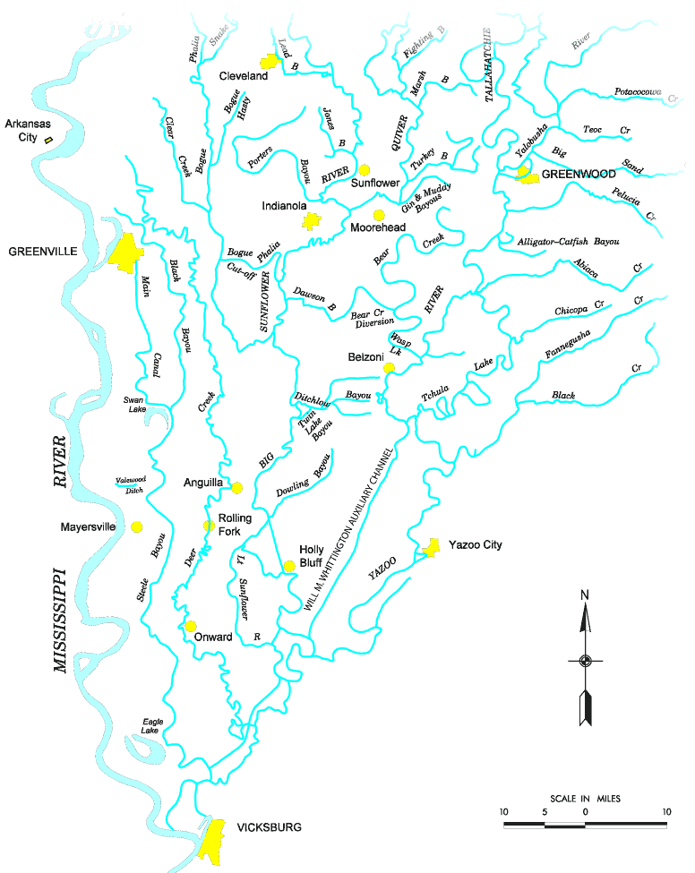
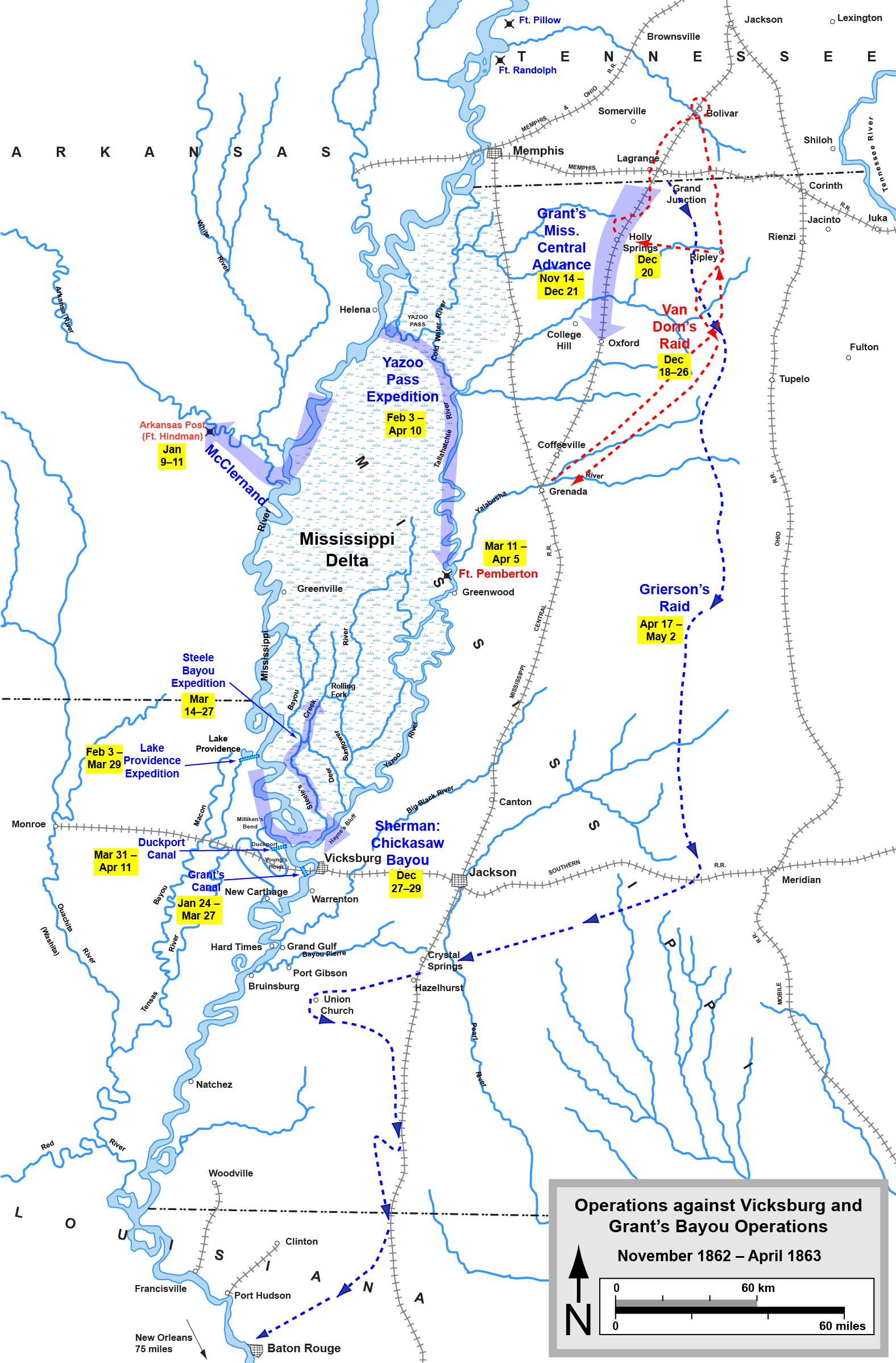
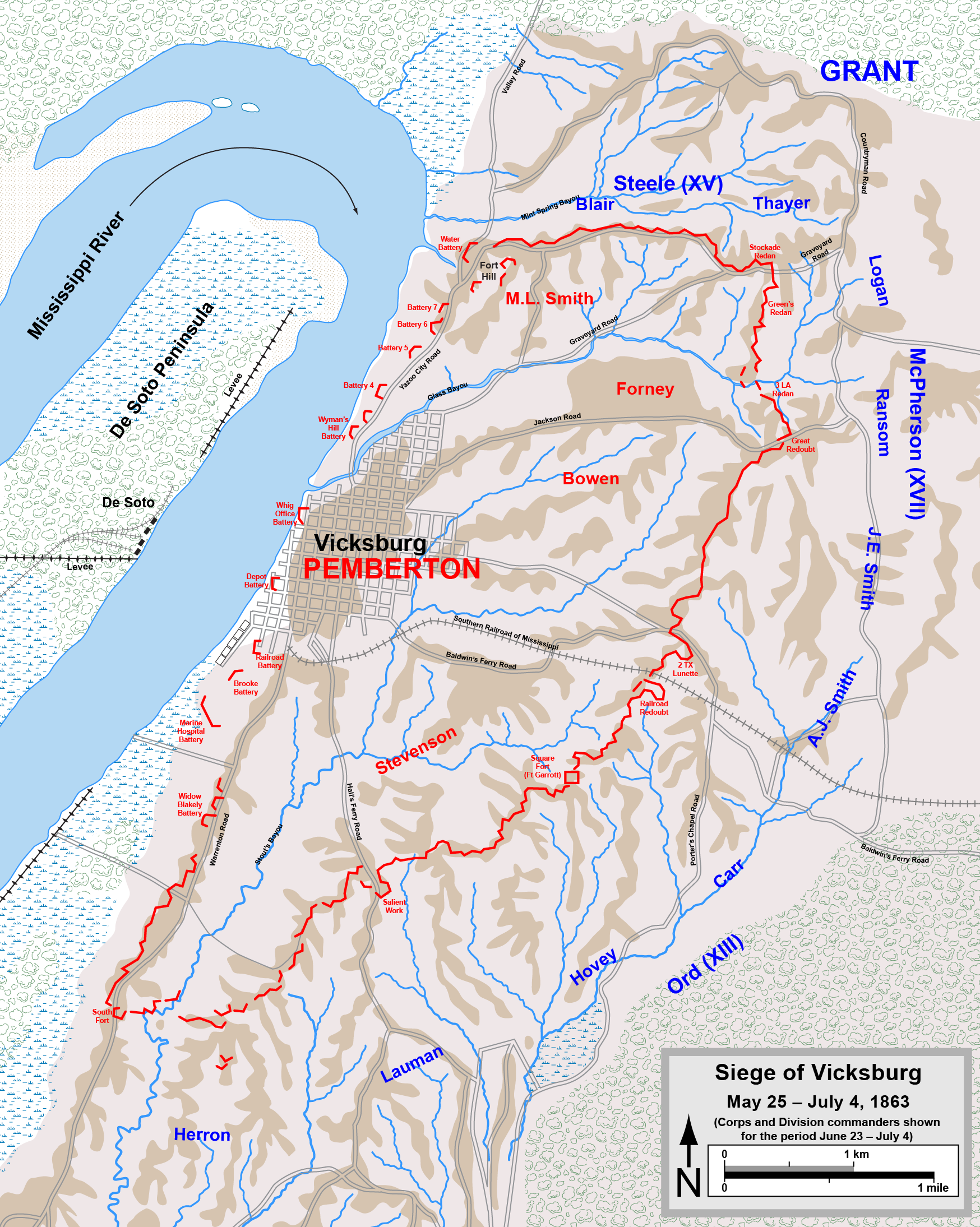
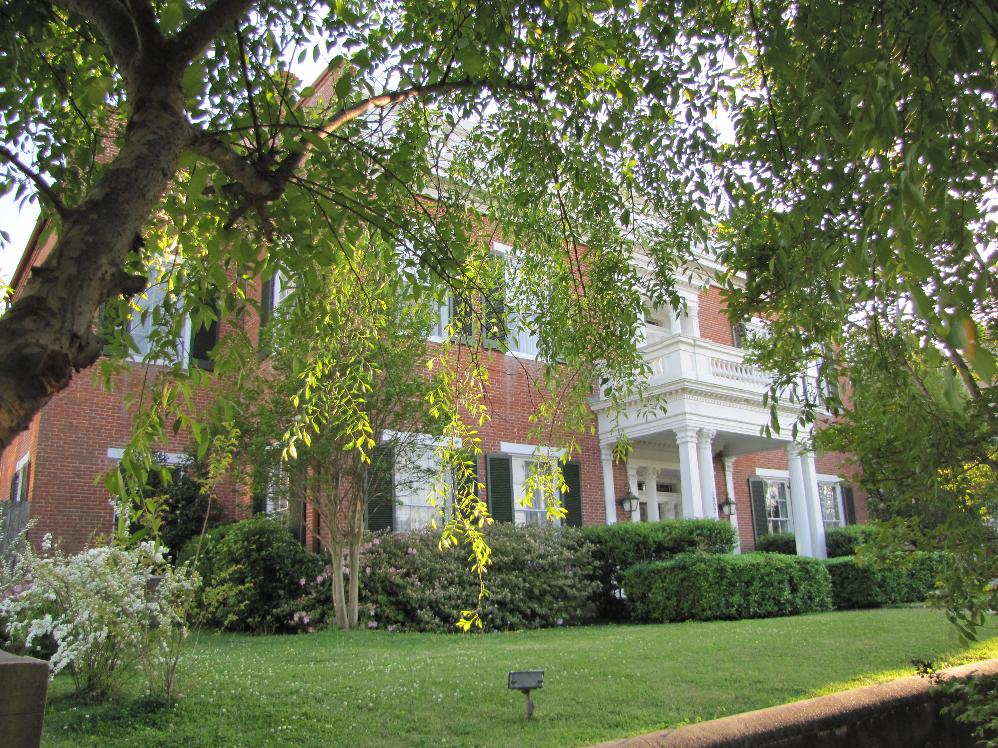
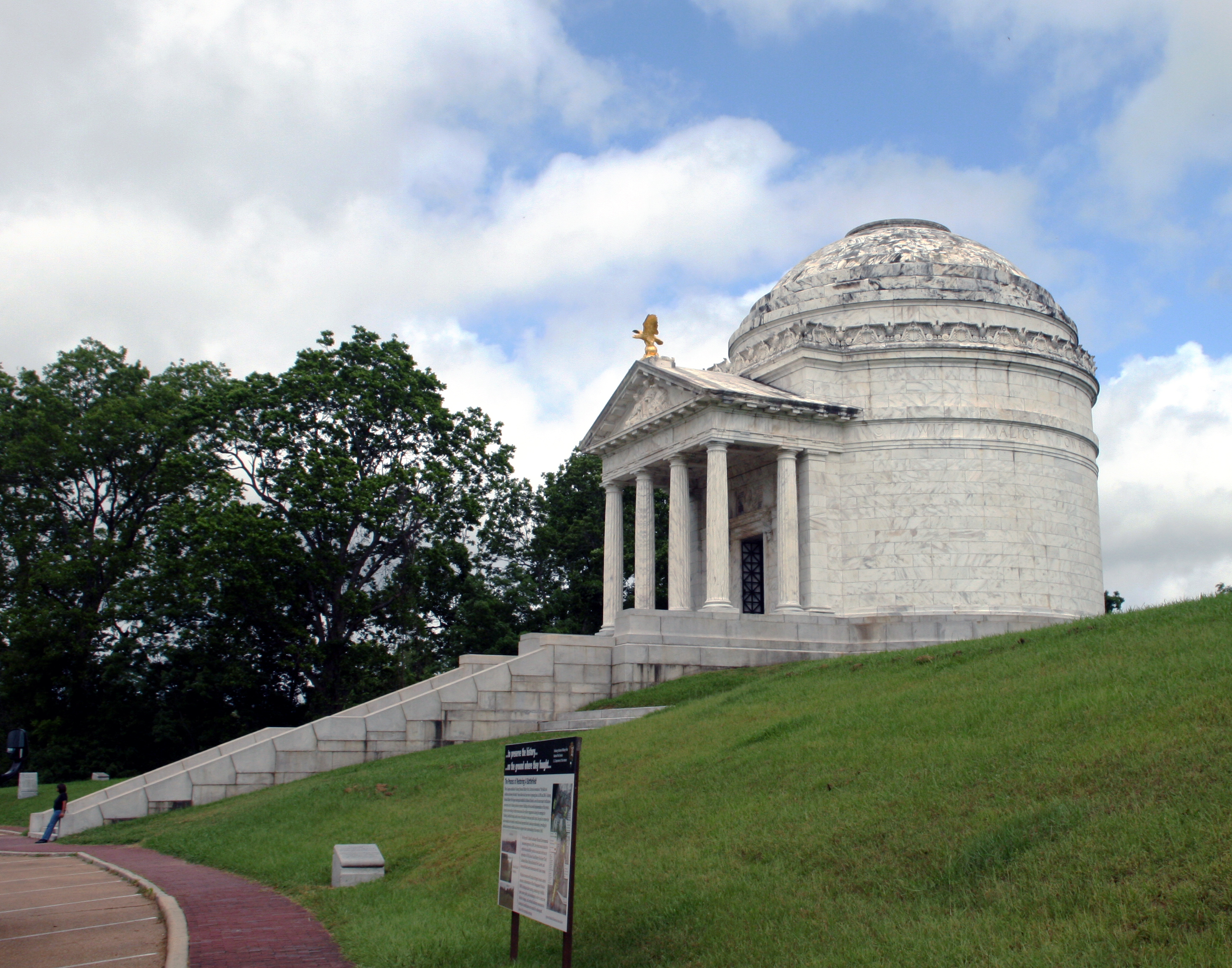
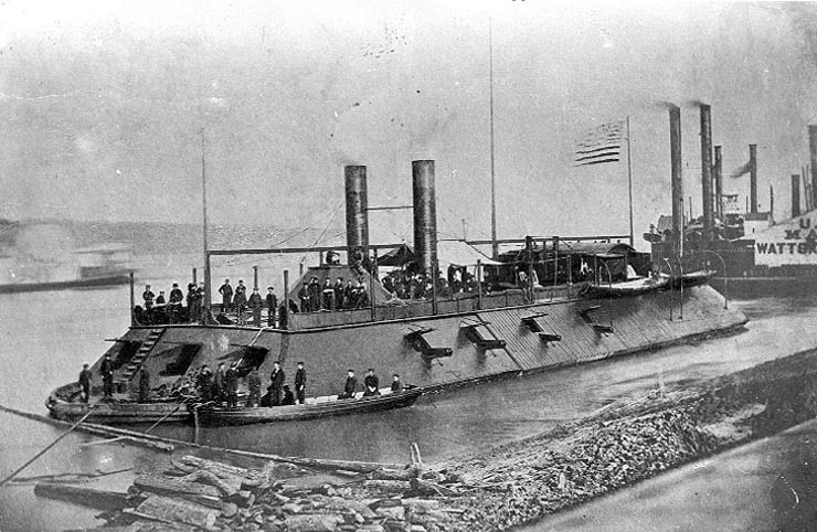
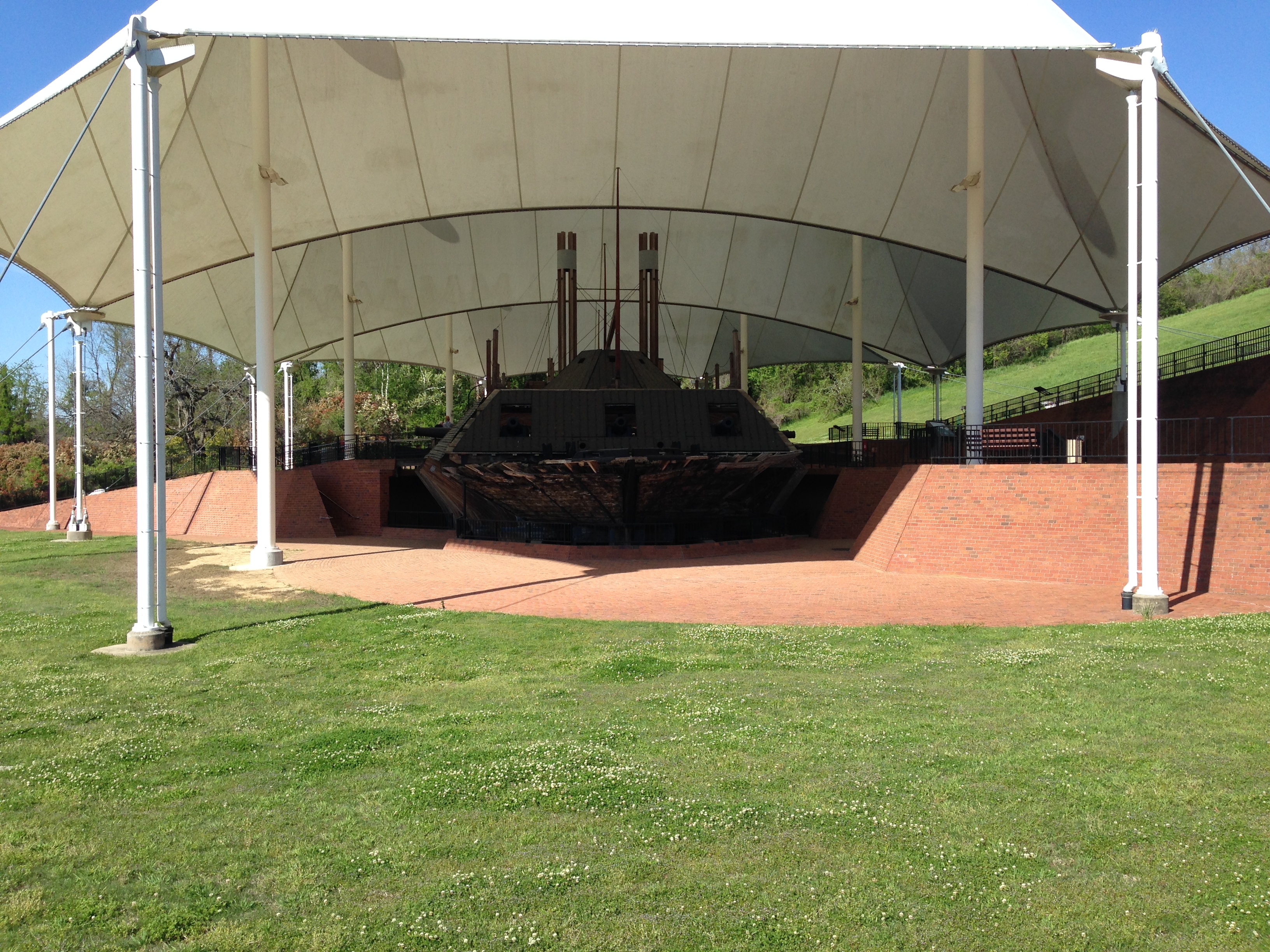
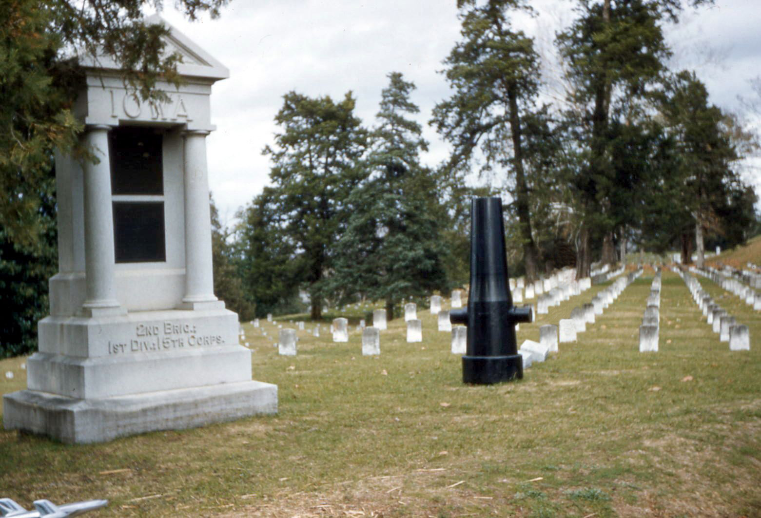
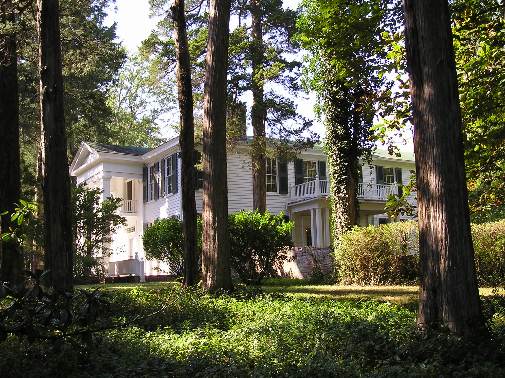
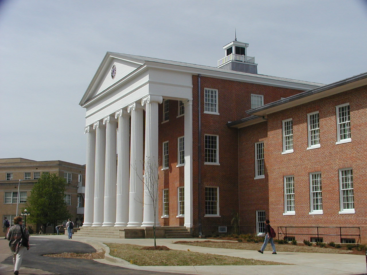