|
Reflections 2016
Series 2
February 11
Westward via Missouri II: Kansas, Atchison to Abilene-Greater Kansas City
| | Day 9: Atchison, Abilene, Kansas City 1 After St Joseph and our first of three nights on or near the Missouri-Kansas border, we're ready to leave Missouri and venture out onto Kansas and the Great Plains. But we need to review why we've taken this side trip west out of St Louis and away from the Mississippi. Certainly it was to ● see Greater Kansas City much better—we only passed through quickly that one time in 1968, saw little, and never got to St Joe at all. Also to ● get a chance to once again drive out onto the Great Plains, even though for such a short distance, to review the experience that the wagon trains had when they left from Independence and Westport. But the immediate reminder was ● to see the Eisenhower and Truman graves and not just their libraries, based on having just seen the LBJ grave last year. The statistical summary of adding these two to the original list is at the beginning of 2015/19.
http://geology.com/cities-map/map-of-kansas-cities.gif
| | | | This first map of all of Kansas is just to judge the size of the state. Kansas would be a rectangle, except for the NE corner, formed by the Missouri River. St Joe (not shown) would be just over the Missouri River, just east of Highland KS. We'll start out here and be cutting over via Atchison and Topeka to I-70 once again as far as Abilene just west of US 77, roughly one-third across the state, then return to Kansas City. Note Seneca KS on US-36 at the top right, Johnny Fry's first stop on his first day as the first westbound Pony Express rider out of St Joe.
http://retireforlessincostarica.com/wp-content/uploads/2012/11/TotoNotInKansas.jpg
| | | | Kansas is used to symbolize one's quiet, familiar, comfortable surroundings in the 1939 film The Wizard of Oz when Dorothy (Judy Garland) says to her dog "Toto, I've a feeling we're not in Kansas anymore." The film quote has become an idiomatic standard to represent being in strange surroundings, out of one's depth, and outside one's comfort zone.
http://media.web.britannica.com/eb-media/62/3062-004-B3DA176D.gif
| | | | For a moment, let's expand our map. In the US, the Great Plains cover all of Kansas in the center, and north of it, Nebraska, South Dakota, and North Dakota. In addition, the area covers, clockwise, parts of Oklahoma, Texas, New Mexico, Colorado, Wyoming, and Montana. When considered as an ecoregion, the area can be considered to extend somewhat further east, as well. In Canada, the area is known as the Prairies, and cover parts of (E to W) Manitoba, Saskatchewan, and Alberta, for which reason these are called the Prairie Provinces. | | | | When in the Great Plains, we are in the center of things. The geographic center of all North America falls in North Dakota, at Rugby. The geographic center of all 50 US states falls in South Dakota, at Belle Fourche. The geographic center of the contiguous 48 US states falls in Kansas, at Lebanon, which is on our Kansas map on the above-mentioned US-36 between Smith Center and Mankato. | | | | But as a comment on the low population in this entire central area, Great Plains and Rockies, the mean population center of the US is much further east—and south--in south-central Missouri. This map shows the ever-westward movement each census of the mean population center of the US as reported by the US Census Bureau. Although in recent decades it finally leapt the Mississippi, Missouri geographically is still in the eastern US. In 2010 the point was 4.3 km (2.7 mi) northeast of Plato MO, and the estimate for 2015 is that it is 12.9 km (8.0 mi) southwest of Plato.
http://people.ku.edu/~buechner/Region.GIF
| | | | But now let's get to the point, and look at a close-up of the Kansas area we'll be traversing over the next few hours—if we get an early start we should be in KC in the early afternoon. We see again how the Missouri River squiggles its way from the northwest to form the irregular border of Kansas and Missouri right up to the edge of Kansas City. You see where we entered the KC area on I-70 from the east, and then took I-29 and its spur to St Joe. West of St Joe, you see the modern US-36 that copies the route Johnny Fry rode as far as Seneca that first night of the eastbound Pony Express. US-36 continues to the above-mentioned Lebanon, off this map. However, that route doesn't take us to where we want to go at the moment. We need to cut diagonally to Topeka to get back on the I-70 to Abilene, then take it back to KC. | | | | Atchison When planning this diagonal route including US-59 months ago I noticed that, by chance, we'd be going right through Atchison, which, along with Leavenworth, lost out on becoming the eastern terminus of the Pony Express because neither had rail service at the time. And you don't need to be an expert to see a famous name in rail history growing out of the name of this town. This local Atchison map shows our US-59 route best of all:
http://pics2.city-data.com/city/maps2/cm3535.png
| | | | Bypassing US-36 in St Joe, we stay in Missouri close to the east bank of the Missouri River right to the point where, once we cross the river into Kansas on the west bank, we're right in central Atchison. These two bridges over the Missouri (Photo by Tim Kiser) explain a lot. Yes, there are two bridges, despite the optical illusion. The other point of confusion is that we're looking south, downstream, so that's Missouri on the left and Kansas on the right, with Atchison. We take US-59 over the taller bridge in the background, which is called the Amelia Earhart Bridge. The aviation pioneer, lost over the Pacific on 2 July 1937, was born in Atchison, and the house where she was born, slightly north of the bridge, is open to the public. | | | | The photographer's caption to this photograph dismissively adds that "The lower bridge in the foreground is a rail bridge." Well, I should say. It's the connection to Missouri of the Atchison, Topeka & Santa Fe Railroad, which was one of the best-known historic railroads in the United States. | | | | Just a few comments under the rubric "Poor Atchison!". We know it lost out to be the eastern terminus to the Pony Express because it didn't have a rail connection. Actually, once St Joe had been chosen because it did have one, a rail extension of the Hannibal & St Joseph RR was made from St Joe to Atchison between 1857 and 1859, so in fact, Atchison was now the rail head in the area for eastern connections, but the Pony Express decision had been made. | | | | After the Pony Express and Civil War eras had passed, the towns in the area we're in were hoping for tremendous growth based on the rail connections replacing the Pony Express that were to be made to California and the West after the Civil War. Now with Atchison as the eastern railhead, it expected to become the regional rail hub with connections to the West. In anticipation of this, in 1859, the Atchison & Topeka RR was founded to build the initial new segment from Atchison to Topeka, the capital of Kansas. Construction was delayed by the Civil War, but in 1863, the federal government gave Kansas a land grant for transcontinental rail construction. At this point, it was decided to build this railroad pretty much along the Santa Fe Trail (discussed below) to Santa Fe, so, when the grant was transferred to the Atchison & Topeka RR, it was renamed the Atchison, Topeka, & Santa Fe RR (AT&SF), which accounts for its lengthy name. But so far, so good. Atchison still had its name involved, and up front to boot. | | | | This is the point in the movie where eerie music begins to play, since fortunes are about to shift. When actual new construction began after the war in 1868, it did not start in Atchison, but instead started at the Topeka end, in a rush to the Colorado border. At the very beginning, Atchison, despite the railroad's name, wasn't connected to Topeka at all. Poor Atchison. | | | | The following map was made some four decades later, circa 1901. It doesn't show all AT&SF routes, but just the principal through car routes between Chicago, Kansas City, and the Pacific Coast. Note how the main line of the AT&SF developed. Kansas City ended up surpassing Atchison as a rail hub due to KS's greater industrial capability and its connections to both Texas and Chicago, as is pointed out in the name of this map. It wasn't until four years later, in May, 1872. that a spur line was connected (see rail map) that bypassed KC and stopped at both St Joe and Atchison, on the way to Topeka. Thus, the 80 km (50 mi) stretch between Atchison and Topeka, the basis for naming the railroad, wasn't breached until later, almost as an afterthought. Poor Atchison. | | | | | | For those who'd like to see the story rounded out a bit, this more complete 1891 AT&SF map while also showing the above, also shows St Louis connections and the above-mentioned Texas connections. You'll recall that on our visit to Galveston this past year (2015/4) we discussed the Galveston Branch and very specifically Galveston's Santa Fe Union Station.
Another slap in Poor Atchison's face was that the short version of the name of the railroad, other than the letters AT&SF or ATSF, was always the "Santa Fe", making no mention whatsoever of its origins in the East. And the irony is that the main line didn't even serve Santa Fe! The details were spelled out when we visited Santa Fe recently (2007/12), but the short version is that Santa Fe is set back in the mountains. The Santa Fe trail, since it ended in Santa Fe, did enter the mountains, but, while Route 66 originally also entered the mountains to Santa Fe on a spur, then exited again to continue to Albuquerque, that loop was later cut off, and Route 66, while coming close to town, really bypassed it and passed through some outer suburbs. Similarly, the AT&SF main line never entered Santa Fe directly. As the route map shows, the AT&SF, including its Super Chief, serviced Lamy NM, near Santa Fe, and in time, a spur line was built to service Santa Fe itself. This continues today, where Amtrak's Southwest Chief connects Chicago and Los Angeles, and, when it stops in Lamy, a half-hour bus shuttle takes passengers into Santa Fe.
The AT&SF merged with the Burlington Northern in 1996 and their combined routes as of 1996 complemented each other very well (Map by Elkman). While known at first as the Burlington Northern & Santa Fe RW (no "Atchison"), the name was later altered to the BNSF Railway, so even any romantic reference to Santa Fe is lost.
|
| | | | As we drive over the Amelia Earhart Bridge in Atchison with the rail bridge on our right, it's only about ten blocks to 10th Street, where a pre-planned right turn for a half-block brings us to the former Santa Fe Depot (Photo by Ammodramus), which now houses the Atchison County Historical Society. The adjacent grain silo indicates we're on the Great Plains. The depot is attractive, as is the town, but there's irony that, even in Atchison itself, it's called the Santa Fe Depot. Poor Atchison. | | | | There are not too many popular songs about railroad companies, and when in Santa Fe in 2007 we first talked about the 1946 film "The Harvey Girls" and presented Judy Garland's version of "On the Atchison, Topeka and the Santa Fe", which won the Oscar for Best Original Song that year for Harry Warren (music) and Johnny Mercer (lyrics). If you want additional information, including selected lyrics, go to 2007/12, then do Ctrl-F "Atchison". We'll repeat the recording here (3:07), and if you still don't catch the slight, one-word difference between the actual name of the railroad and the title of the song, refer back to the old posting, where it's spelled out in detail! | | | | Abilene Now go back to our regional map, and follow our route, taking US-59 and KS-4 to the Topeka area, where we get back on I-70 out to Abilene. There we take the main road south to the southern part of town where we come across the Dwight D Eisenhower Presidential Library and Museum. | | | | We may picture Dwight (DDE) and Mamie Eisenhower as rootless, after years of military and presidential wanderings. Or, we may remember, that they retired, perhaps surprisingly, to Gettysburg, Pennsylvania. We may remember, when talking about the Germans in Fredericksburg, mentioning last year (2015/3) about DDE being born in Texas, in Denison north of Dallas. We also said: His ancestry was, however, Pennsylvania German, originally from Karlsbrunn on the French border near Saarbrücken. The spelling of the name was anglicized from Eisenhauer, literally "iron hewer", presumably meaning "ironcutter". We can now elaborate on that. Accounts vary as to how and when the spelling change of the name took place, so the answer is not definitive. However, his Eisenhauer ancestors first settled in York, Pennsylvania, in 1741, so his move later in life to Gettysburg, being just a 50-minute drive from York, was in a historic sense, "going home". | | | | But it was actually incidental that DDE was born in Texas. The Pennsylvania relatives moved to Hope KS, in the Abilene area, in the 1880s. DDE's mother, from Virginia, and also of German ancestry, met his father in Kansas and they married there. But their business in Hope failed, and they moved to Denison, where they stayed between 1889 and 1892. After that, they returned to Abilene and were successful in business this time. In that way, all of DDEs brothers were born in Kansas; his two older brothers were born in Hope, and his younger brothers in Abilene. But when DDE was born in 1890, the family was transitionally in Texas. Thus he considered Abilene his home town, even though he wasn't actually born there.
http://media.web.britannica.com/eb-media/14/164814-004-4972A699.jpg
https://www.eisenhower.archives.gov/all_about_ike/eisenhower_brothers/images/62_318.jpg
| | | | Two family portraits, first in 1902, then in 1926, with everyone located in the same position. In addition to father David and mother Ida, we have the five surviving brothers, numbered as to age rank: Dwight (3), Edgar (2), Earl (6), Arthur (1), Roy (4), with Milton (7) up front. Paul (5) died at 10 months of diphtheria. | | | | This family had naming confusion. Ida originally named DDE David Dwight, but reversed the two names after he was born to avoid confusion with father David, probably a wise move. But when it comes to names, no one can really explain the name "Ike". All the boys were called Ike, requiring a further breakdown—Edgar was called Big Ike and Dwight was called Little Ike. DDE thought the name had something to do with the first sounds of the family name, but that's hard to see. By the time of WWII, only Dwight was still called Ike, and the name stayed with him. Still, if Ike is a nickname for anything, it would be Isaac, something few realize, but that name seems to have little if anything to do with the family. | | | | But to the point: DDE attended elementary school through high school in Abilene. He lived with his family in the house here from 1898, when he was 8, until being appointed to West Point in 1911 at age 21. The family occupied this house until his widowed mother's death in 1946. | | | | DDE married Mamie Doud when he was 25 and she was 19. This
picture was taken that same year, 1916. However, I've yet to point out the additional poignancy of visiting the Eisenhower grave site, because of the tragedy the couple suffered a few years after this picture was taken.
http://www.nps.gov/museum/exhibits/eise/Mamie/family/EISE15817aT.jpg
| | | | This is a portrait of Doud Dwight Eisenhower (1917-1921). He was given his mother's maiden name, plus his father's first name. But he was really not called that. Everyone called him Icky. That word today might seem humorous, but all I can guess was that it was a diminutive of the family name Ike, as used by his father and uncles: Ike plus -y being altered to "Icky". Icky was born in September the year after the previous picture was taken. This is a family portrait with Icky where he seems to be a little bit younger. | | | | The family left Kansas and relocated in Maryland, I assume within a military framework. At one point, Mamie hired a 16-year-old servant girl who had been recovering from scarlet fever. In 1920, just before Christmas, Icky came down with that disease. Mamie tried desperately to save him, even calling in a specialist from Johns Hopkins in Baltimore, but Icky died the day after New Year's Day in 1921. He was three years and 3 1/3 months old. The couple blamed themselves for Icky's death, feeling they hadn't checked the girl's background carefully enough. DDE called Icky's death the most shattering moment of their lives, one that almost destroyed their marriage. It's now appropriate to point out that Icky is buried along with DDE and Mamie in Abilene. | | | | The couple did have another child, a son, the very next year, John Sheldon Doud Eisenhower (1922 – 2013). Perhaps including Doud in his name was not only a reference to Mamie, but also to his older brother. He was a US Army officer and military historian. Like his father, he attended West Point. He graduated on 6 June 1944, the day of the Normandy landings, which his father was commanding. | | | | As we now visit what is more familiarly called the Eisenhower Center, I refer back to one of our travel diaries to point out that we were previously here on 29 June 1968 and saw what we wanted to see. However, there was no gravesite at that time since DDE only died the following year, on 28 March 1969. So the purpose of this trip is limited, not involving the library or museum. | | | | This is a general view of the grounds of the Eisenhower Center (Photo by Scott Catron) showing, along with the boyhood home and statue (click), a very typical Great Plains view, with grain silos in the background, just as we saw in Atchison. Here is a detail of the Eisenhower family home (Photo by CSvBibra), so typical of the region. While entry is free, there's a timed-ticket entry projecting into the afternoon, so we'll have to go with having toured it in the past. But very attractive is the area around the Eisenhower statue (Photo by Chuckmor), showing him wearing the waist-length Eisenhower jacket he was known for and had requested for his troops toward the end of WWII.
| | | | Facing the above views is a small, seatless, chapel-like building called the Place of Meditation, which contains the graves (Photo by CsvBibra) of Dwight David Eisenhower, 1890-1969; Mamie Doud Eisenhower, 1896-1979; and their first-born son, Doud Dwight "Icky" Eisenhower, 1917-1921. Details are shown in these two links:
http://images.mentalfloss.com/sites/default/files/styles/insert_main_wide_image/public/eisenhowers.jpg
http://f.tqn.com/y/dying/1/S/U/1/-/-/EISENHOWER_DOUD_MARKER.jpg
| | | | This quick visit to Abilene allows us a brief review of the personal and family side of DDE covering the early years, after which, it's back on I-70 to KC. But we've been talking about the open flatness of the Great Plains, and should take a better look. This view shows the area of Kansas plains (Photo by Chris Light) in Nicodemus KS, about 2.5 hours further west of Abilene, but the view is typical of the region. Knowing that this was an ancient inland sea helps to understand the flatness of this "sea bed", and how it became grasslands, and today mostly agricultural land. | | | | Westward Expansion of the US Part of the I-70 route eastbound is simultaneously the Kansas Turnpike, a toll road (see area map). But as we approach the large KC Metropolitan Area, our final driving destination for the moment, it's finally time to discuss in a bit more detail the phenomenon of the mid-19C Westward Expansion of the United States, as embodied by the Arch in St Louis. We'll continue to, use the metaphor of a funnel on its side (2016/1) that started from St Louis/St Charles and lay westward across Missouri to Independence and Westport in the KC area, from where the bell of the funnel fanned out across the West over several trails to the Pacific. The KC Metropolitan Area owes its existence to these events, so, before we look at the past, we need to take a look at the present. I will admit I'd had no idea whatsoever how these events were so interestingly linked until I dug into it for this trip. | | | | Kansas City Metropolitan Area It's confusing that there are two places named Kansas City, that they adjoin each other, and that the one which by far is the more important is not in Kansas, but in Missouri. That's Kansas City MO, or KCM, as opposed to Kansas City KS, or KCK, a situation we'll explain as we proceed. Just be aware that the unmodified mention of "KC" almost assuredly will be referring to KCM, so much more is its importance. And I was surprised when I found out the importance of the Missouri River and steamboats in this area to both the Westward Expansion and to the urban development of KC. I find it hard to imagine the US developing as it did without the steamboat. It's simply amazing. | | | | Let's first go up in the sky to get a satellite image of the KC area (click). It's refreshing to get a look at the natural environment before we draw political borders. The Missouri River flows west to east on its way to the Mississippi. On the south side of its lowest bend is the urban core of KC. Coming in from the southwest is the Kansas River, which flows into the Missouri not far from the urban core. Now let's add state lines. The KS-MO state line north of the confluence follows the Missouri River, as we know, forming that irregular border we talked about. But now figure a straight line north-south KS-MO border coming down from just east of the confluence so that every bit of the Kansas River is physically in Kansas, as close to KCM as it may come. Finally, look at the Cupid's bow formed by loops of the Upper Missouri and Kansas Rivers. In its center is a point of land on the west bank of the confluence. This will be our first stop in a moment, Kaw Point, a park where Lewis & Clark first surveyed the area. | | | | Now compare the satellite map with a last look at the regional map we've been using to see the winding border up at St Joe, and the straight line south of KC. Also take note of the unfamiliar name of the town of Overland Park KS. Also find Wichita for later reference. Then copy and paste the below link for our KC map and keep it handy.
http://www.lib.utexas.edu/maps/world_cities/kansas.jpg
| | | | Lots of metropolitan areas straddle state lines, the most recent one we've dealt with being Saint Louis, with its core in Missouri, but with extensive suburbs both in Missouri and in Illinois. Similarly, KC has its core in Missouri, but with extensive suburbs both in Missouri and in Kansas. The KC metropolitan area encompasses fifteen counties in both states, with a total population of 2.34 million, second only to Greater St Louis. | | | | Within this area, KCM itself is easily first in population (471k), but it may surprise that the second city in population is Overland Park KS (185k). Only after that does KCK fit in in third place (150k); fourth is Olathe KS (133k) to the southwest, and finally, again on the Missouri side, is Independence (117k), where it all started. | | | | These regional statistics blur the state line. If we just consider cities in Kansas, Wichita (the A is pronounced AW), at 387k, is the largest city in the state, more than double the next two combined, Overland Park and KCK. But on the other hand, the KC metro area is much larger than Wichita. | | | | Departure Points to the West Now that we know our area, let's peel off a few layers of history and go back to the early-to-mid-19C. More specifically, emigration left from this area from the late 1830s up to the Civil War. We already saw the population-based "why here" story in the last posting, but here are two more excellent illustrations:
http://lincolnhome.dcl.niu.edu/remann/pictures/us_1850_totpopden_040701_400.jpg
http://lincolnhome.dcl.niu.edu/remann/pictures/us_1860_totpopden_040201_400.jpg
| | | | We have here the results of the US Censuses of 1850 and 1860. In the first case, emigration to the West had been going on for over a decade, and already we can discern the built-up area crossing Missouri and reaching furthest west from the block of population in the East. A decade later, population growth in Missouri and adjacent areas was even more pronounced, as was growth in California of those who'd already made the trek. And in 1860, the density of the KC Metro Area is particularly pronounced. This was clearly the outpost where migrants should start their crossing of the Great Plains and the Rockies. | | | | Discard these and return to our KC map as we identify our two area sources of emigration, which I'll call, for ease of understanding (1) Independence and (2) Westport-cum-Kansas City. That there are two is just as interesting as what happened to the second one. | | | | I personally first heard of Independence because President Truman repeatedly boasted as being from there. But long before that, Independence became famous as being the departure point of the major trails to the west, the Santa Fe, Oregon, and California trails, giving it the nickname of "Queen City of the Trails". Its unusual name is a reference to the Declaration of Independence. It was founded in 1827 and its location was due to its being—at the time--the farthest point westward on the Missouri River that steamboats could travel, putting it on the edge of US civilization. It developed into an important frontier town, then a jumping-off point for the merchants and adventurers using the Santa Fe Trail. At this point we should note that the Santa Fe Trail, before it became a point of emigration, was a mercantile trail (more later). Independence's height of prosperity was not too long, from the late 1830s through the mid-1840s, when the trade changed from merchants going to Santa Fe to the business of outfitting pioneers going to settle the West. Even as its share of business declined in favor of Westport, it continued outfitting pioneers through the Civil War period. In subsequent years, unlike Westport, it remained an independent local municipality. | | | | [On our map, find Independence and locate the Truman Library, and follow the red road south to the third red crossroad. This is roughly the area of departure, as embodied today by the National Frontier Trails Museum. Now locate the Blue River flowing north to the Missouri and separating Independence from KC. Finally, in KC, to find Westport (not on map) locate the bend in the red road to the NW of the Nelson Art Gallery. The road is Broadway, and the bend shows Westport. Broadway connects Westport with downtown KC on the Missouri.] | | | | Our other starting point, somewhat further west, had a dual identity, but we'll start by just calling it Westport. Some of the local settlers well east of Independence, beyond the Blue River, preferred settling in the hills to the south of the Missouri, avoiding the floodplain, and others wanted to be right on the river. John Calvin McCoy, called the "Father of KC", was involved in setting up establishments in both areas. In 1833, six years after Independence was founded, McCoy opened a trading post up in the hills some 5 km (3 mi) south of the river, which he named Westport to indicated its position on the trails that was further west than Independence for getting supplies. As was indicated in the Trails Museum in Independence, one of the factors that started drawing business from Independence to Westport was that it shortened the westward trek by one day and also avoided having to bring wagons across the Blue River. In addition, as of 1836, a sandbar had formed at Independence Landing, impeding commerce. | | | | Because of Westport's distance from the river, a trail north developed, now called Broadway, to a point on the Missouri where there was a rocky outcropping that served as a natural wharf. It was located at a spot that now between Main and Grand Streets in KC. This area was called Westport Landing, which steamboats could now reach. In 1834 the steamboat "John Hancock", laden with goods for McCoy, was the first to dock at Westport Landing. After this, Westport Landing began to take on a life of its own as a trading post and transportation hub. McCoy and others got together and formed in 1838 the entity that eventually became Kansas City. | | | | By 1850, Westport and Kansas City together displaced Independence as the principal outfitting hub, with Westport's greatest prosperity coming between 1854 and 1860. During the Civil War, trade fell sharply and never recovered in Westport. Meanwhile, KC grew rapidly, and got the railroad connections. Eventually KC spread south and annexed Westport in 1897. It's a classic "tail-wags-the-dog" story, where the town's transportation hub takes over the original town. Today, Westport remains as a historic neighborhood of KC, and serves as one of KC's main entertainment districts. | | | | The Name "Kansas" One of the most confusing naming situations I'm aware of involves the word "Kansas", with two cities being called Kansas City, and the principal one not even being in Kansas. After delving into the origin of the name, I find I can now think of at least three US states whose names are the plural form of a local Native American people. I'd like to start with the one state at a distance from our present area of study. The Massachusett people historically lived in the areas surrounding Massachusetts Bay and present-day Boston. You can refer to them collectively as the Massachusett (just as you'd say "the Navajo"), or with a more familiar S-plural as the Massachusetts (as you'd say "the Navajos"). The state of Massachusetts (the Bay, too) is named after the S-plural form of the ethnic group. The story is similar with Kansas and Arkansas. Let's take them one at a time. | | | | We start with the Kaw Nation, which has an alternate name spelled either Kanza or Kansa. From 1780 to 1830 the Kaw lived at Blue Earth Village on the Kansas River, at the site of present-day Manhattan KS, between Abilene and Topeka. They became increasingly hemmed in by American settlers and other native tribes moving west. They eventually were pressured out of their native lands entirely by settlers, and so they emigrated south to Indian Territory (today Oklahoma). They spoke a Siouxan language called Kansa, but the last native speaker died in 1983, so the Kaw Nation offers online language learning for Kansa second-language speakers. The Kaw Nation, about 3,000 strong, is today centered in Kaw City, Oklahoma, just south of the Kansas state line and about 1.5 hours south of Wichita. | | | | Two maps should clarify this. This is the watershed of the Kansas River (Map by Kmusser), located primarily in Kansas though partially in Nebraska and Colorado. Though this river comes very close to Missouri, none of it is physically in Missouri. The original home of the Kaw, today Manhattan KS, is at the junction of the Big Blue and the Kansas Rivers. Note that the alternate name for the Kansas River is the Kaw River, and where it meets the Missouri, the west bank is called unique Kaw Point--we'll be visiting Kaw Point Park shortly. | | | | Even clearer is this tribal map of the area (Map by Nikater). The German text (click) indicates that former tribal lands are in green and today's reservations are in orange. You will find both original and contemporary Kansa lands. | | | | Now fortified with this background, we can see how our word in question developed. As with the Massachusett, in English you can call this people the Kansa or the Kansas (but make that a clear English plural, pronounced in this case as Z). It's obvious that in time, the word was no longer seen as a plural (as with the state of Massachusetts) and was pronounced Kansas, ending in an SS sound. This was then applied principally to the Kansas River, where the Kaw had lived. To prove you understand this, pronounce correctly "The Kansas were from Kansas". | | | | Other than the Kansas River, the first actual land area to use the word as a place name was the aforementioned Westport Landing, when, trying to distance itself from any secondary status to Westport, it decided to rename itself. Though located fully in Missouri, it nevertheless decided to use the fact that it was near the confluence of the Kansas River into the Missouri to rename itself in 1838 with the one-word name (1a) "Kansas", or, by extension, the "Town of Kansas". Thus, no territory, no state, and nothing within Kansas proper has dibs on the name—KCM does. I'm surprised at this discovery. | | | | When this new Kansas/Town of Kansas was then incorporated in 1853, the state of Missouri elevated it officially to the (1b) City of Kansas. Thus to about mid-century, this city (and the river) was unique in using the name. But in 1854, much of the watershed of the Kansas River, including the part in today's Colorado, was formed into the (2a) Kansas Territory (Map by Fay2). Then, in 1861, the roughly 1/3 of the territory lying in today's Colorado was separated from the rest, and the bulk of the territory became (2b) the State of Kansas, so the state, surprisingly, is only the second land area to use the name. | | | | The final adjustment in the name of KCM came in 1889, where the name City of Kansas was restyled as (1c) Kansas City, as we know it today. And as we see, although we mark it as KCM to make clear what we mean when necessary, it continues to be fully justified to use the simple designation KC. | | | | But then we have a third level of confusion. In 1872, on the Kansas side of the border, (3a) "old" KCK was incorporated as the City of Kansas City. In 1886, that was consolidated with four other municipalities, the oldest of which dated back to 1857, to form the "new" KCK (3b). It saw explosive growth as a streetcar suburb to KCM, to which KCK actually owes its name. There was a period of history where it was very popular for towns to name themselves after adjacent more famous towns, such as West Palm Beach FL shining in the glory of Palm Beach, and West New York NJ, lying across the Hudson from New York City. Thus, KCK named itself after KCM, although I wish they'd called themselves "West Kansas City" rather than using the same name plus the state designation, as it would have been so much clearer. | | | | There's more. In 1997, KCK did what several other US municipalities did. It consolidated itself with its county—think of Miami-Dade--with its current name becoming the incredibly unwieldy (3c) "Unified Government of Wyandotte County, Kansas City, Kansas". But unlike the brief name Miami-Dade, no simple name has evolved, so locals continue calling it KCK. | | | | Summary: KCM used the word "Kansas" first, then the State, then KCK. But the result is this. Though Mexico City is in Mexico, Panama City in Panama, Oklahoma City in Oklahoma, New York City in New York, plus numerous others, Kansas City (the most authentic one) is NOT in Kansas. However, I can think of one other such example. The mining town of Virginia City, site of the famous Comstock Lode, is in Nevada. | | | | We would be remiss if we didn't also discuss Arkansas here, especially since we were just there earlier in this trip. The derivation of the name is related to that of Kansas, which should not surprise. But in this case, we're discussing the Quapaw people, whose traditional territory was at the junction of the Arkansas and Mississippi Rivers. However, in 1834, they were removed west to Indian Territory (Oklahoma) and reside today in Quapaw OK, east of the Kaw people and closer to the Missouri/Kansas border. They number over 3,200, and the Quapaw language is another branch of Siouxan. There are few remaining native speakers, but classes in Quapaw are taught at the tribal museum. | | | | This doesn't seem helpful until we realize the exonym involved. Remember, an exonym is a name given by outsiders, such as with English speakers calling Deutschland Germany, or French speakers calling it Allemagne. In this case, Deutschland is the endonym, or "insider name". As it turns out, the Quapaw also had an exonym, given by the Iroquois and other Algonquian-speaking peoples to the northeast: they were called the Akansa (also with other spellings). But in this case, a French influence is involved in more than one way. The French Explorers of the Mississippi Region Jacques Marquette and Louis Jolliet met the Illinois peoples before they met the Quapaw, and so adopted the Illinois exonym for the Quapaw, which they rendered in French as les Arcansas, which seems to be the first instance of an R being inserted. In this case, we have an instance of not an English plural, but a French plural, where the S is not pronounced, not even in the English version. This name was respelled with a K in English as Arkansas. | | | | But we're not done—that's just the spelling. The final sound in the French word was AH. It would seem that English people had difficulty with that, and pronounced it AW, but still avoiding the S. This pronunciation is similar to that of Wichita, and things would be simplified if we adopted new spellings, Wichitaw and Arkansaw, but no one listens to me. In any case, the name Arkansas went from the tribe to the river to the territory to the state, and there we are. | | | | Covered Wagons and Outfitting Them We should mention the vehicles that left Independence and Westport to the West, and just what was meant with outfitting the settlers with supplies. | | | | Once winter was gone, each spring during this era, the center of what today is Independence was blanketed by thousands of emigrants, complete with wagons, teams, other livestock, tents, cargo, and supplies. There was commotion, confusion, and excitement as others purchased wagons on the spot, and loaded them with supplies and provisions for the road. Water was available for horses, oxen, and other livestock. Finally, based on destination, wagons were organized into wagon trains. Advice was also given as to which Indian tribes to avoid. | | | | Between 1840 and 1860, about 400,000 people took part in this western migration, although about 10%, or 40,000, died along the way and were buried in unmarked graves along the route. However, unlike in the Hollywood film versions, Indian hostilities caused very few of these deaths. Thousands of wagon trains made their way along the trails, crossing prairies, deserts, and mountains. They faced storms, mud, rivers, accidents, dust, thirst, plagues, and other dangers as they were looking for new opportunities in the West. This trek ranks today as the largest voluntary, overland mass migration in world history.
http://1.bp.blogspot.com/-1SoSLOSjVJc/UozZcWGFkbI/AAAAAAAAICc/nI-YYtipSSY/s1600/diagram.jpg
| | | | Most of the covered wagons used were ordinary, generic farm wagons back-fitted with canvas covers. However great use was also made of Conestoga wagons (above link), which were purpose-designed for long-haul moving. They were heavy, and large enough to transport loads of up to six tons (5.4 metric tons). They were designed to keep the contents from shifting about while moving and to aid in crossing rivers and streams. They were named after Conestoga Township in west-central Lancaster County, Pennsylvania, and were indeed built there, although it cannot be proven that they were invented there. | | | | Covered wagons going short distances on good roads could be drawn by horses, but those crossing the plains were usually pulled by two or more pairs of oxen. A teamster or drover would walk along on the left side of the team, controlling them with verbal commands and whipcracks. Mules were also used, controlled with reins from the wagon. | | | | I've mistakenly always pictured covered wagons as including living quarters, but I'm apparently wrong. They mainly transported cargo and supplies, but also small children, the elderly, and the infirm. Since none of these wagons had suspensions, the ride was rough even on good roads, to say nothing of trails in the wilderness. Those who could, walked along the side. | | | | One covered wagon generally carried the belongings of five people. A family of means might have two or three wagons, but on the other hand, a group of single men traveling together might share one. When stopping for the night to camp, the wagons would form a circle, perhaps around a common campfire, but also for mutual assistance and occasional defense. This of course remains with us today in the North American expression "circling the wagons", used when referring to uniting to take a common defensive position. | | | | The covered wagon has the fanciful, romantic nickname, Prairie Schooner, comparing the wagon to a kind of boat navigating the Great Plains, its broad, white canvas cover evoking canvas sails on the boat. It's a beautiful image, but only those of us who realize that the Great Plains were once actually the North American Inland Sea will fully appreciate the irony of the name. | | | | Because we today are a mechanized society and no longer rely on animal power, it's just that much harder to set our minds to visualize what covered wagon travel was like. To help us, we need to jump ahead some eight decades from the 1850s to the 1930s, when the automobile age was well upon us.
http://www.kimberlyapril.com/wp-content/uploads/2011/02/okies%28pp_w900_h614%29.jpg
https://diaryofamadbabyboomer.files.wordpress.com/2014/12/dust_truck.jpg
| | | | This was the period of the Great Depression and of the Dust Bowl in the southern Great Plains. People were disparagingly called Okies, whether actually from Oklahoma or from neighboring states. We also refer to the Joads in Steinbeck's The Grapes of Wrath. While the 19C and 20C time periods differ in that the earlier group came from the East, on wagons, and perhaps took the Santa Fe Trail, while the later group started from the plains, was mechanized, and perhaps took Route 66, both groups were looking for a better life on the Pacific Coast. Perhaps the pictures of kids and cargo on cars bring home more easily to us a similar situation on the covered wagons. | | | | The Three Major Trails West In 2007/12 we had a rather complete discussion all Routes West, including trails, rails, and highways, and you can go to that posting and do Ctrl-F "Trails" to review it. Now, though instead, we'll condense the topic to specifically the three major trails out of Independence and Westport, one taking the southern, one the northern, and one the central route to the west coast.
| | | | The southern route west was the Santa Fe Trail, which was begun in 1821. As mentioned, it was for trade with Mexico in those earliest years before it became an emigration route.
http://steamboattimes.com/images/maps/map_santafetrailfromindependence1415x725.jpg
http://upload.wikimedia.org/wikipedia/commons/9/98/Map_of_Santa_Fe_Trail-NPS.jpg
| | | | It didn't originally start in Independence. When we were in St Charles (2015/19), we showed two maps of the Boone's Lick Road, a trail that reached west to Franklin MO on the Missouri River about halfway across the state. Technically, the Santa Fe Trail started in Franklin, before Independence took over as the prime provisioning point, after which, for all practical purposes, the trail started in Independence. | | | | The first map above shows a good closeup of the Santa Fe Trail, and the future (1880) route can be foreseen of the Atchison, Topeka & Santa Fe railroad. Poor Atchison is not shown, but is located on the Missouri River about twice as far away from Independence as Fort Leavenworth. Even Topeka isn't on the trail, because—surprise!—Topeka is instead on the Oregon Trail going northwest, so close together are the eastern ends of the trails. | | | | The Santa Fe has two branches. Slightly longer is the Mountain Route to the north. The southern route is the Cimarron Route, and its alternate name of Cimarron Cutoff indicates that it's shorter. But it was more dangerous because of lack of water sources. The length of the trail via the Cutoff is very roughly 1300 km (800 mi). | | | | | | A personal reflection: when we left KC in 1968 we were historically inexperienced enough not to realize that the US highways we took to Santa Fe (and on to California) closely paralleled the Santa Fe Trail. I remember that we stopped in Dodge City (near Fort Dodge on the map), famous in American culture for its history as a wild frontier town of the Old West. To this day, American English usage retains the expression "to get out of Dodge", meaning to escape a location before trouble starts. I'm also very aware that the only time I've ever been in Oklahoma was when we drove diagonally across the tip of its panhandle, which means we took the Cimarron Cutoff without even realizing it. |
| | | | The second map (click) is a magnificent illustration and great online find. To begin with, we have the illustration of a Conestoga wagon pulled by three teams of oxen driven by drovers, walking on the left. But the map shows more transportation than just the trail. In implies non-oceanic European connections to Mexico City starting in New York. The Morris Canal across NJ and Pennsylvania Canal, both discussed in 2006/10, are shown as an initial route. From Pittsburgh there are the river connections on the Ohio, Mississippi, and Missouri, followed by Santa Fe Trail connections leaving either Independence or Westport, via either the Mountain or Cimarron Routes. | | | | We also see the importance of the city of Santa Fe in North American history. It was a northern outpost of Mexico, more important than California, and the hub of a major foreign trade route. It had direct connections to Mexico City via El Camino Real (The Royal Road), which completed the trade circuit. I've also read that the languages heard along the culturally diverse Santa Fe Trail included English, Spanish, German, French, Dutch, and those of several Native American tribes. | | | | But does a certain lack of information strike you? What struck me is that all the information on this trail involved its original use for commerce. But how did the later emigrants reach California? No one seemed to talk about that, so more online digging was necessary, and what came up was the Old Spanish Trail. | | | | It really is old. It was first developed by the Spanish, based on native trade routes, so apparently they did after all want to connect California with Santa Fe, again for trade purposes. They started working on it, rather amazingly, in 1598. The Mexicans, then Americans, took over its development between 1821 and 1830 and completed it. The Old Spanish Trail (Map by Zapus) had a brief, but furious heyday between 1830 and the mid-1850s connecting Santa Fe and Los Angeles. It had several branches at its eastern end, then passed through southern Nevada and California's Mojave Desert and ended at the San Gabriel Mission in San Gabriel CA, a short distance east of today's Los Angeles. | | | | The trail, abut 1,900 km (1,200 mi) long, ran through areas of high mountains, arid deserts, and deep canyons. This trail is considered to be one of the most arduous of all the trails in the US. But while the Spanish founded Los Angeles in 1781, it grew and changed little well into the 19C, despite any migration over the trails. Monumental growth only started with the completion of—can you guess—the Santa Fe Railroad line from Chicago in 1885, at which point immigrants flooded in. All in all, though, we really have to consider the southern migration route (pre-railroad) to be a combination of the Santa Fe and Old Spanish Trails, for a total combined distance of 3,200 km (2,000 mi). | | | | The northern route was the equally famous Oregon Trail, which, oddly, was also about 3,200 km (2,000 mi) in length. It went to the Oregon Country (2008/20), which had also been the goal of Lewis and Clark. The Oregon Trail had been established between 1811 and 1840 by fur traders, and by 1843, began to be heavily traveled by settlers heading northwest, with the principal years being 1846-1869. As the map shows, the principal point of departure was again, Independence. It shared the route with the Santa Fe Trail, but then crossed the Kansas River by ferry near what is today Topeka, the capital of Kansas, so was a factor in the development of that city. | | | | There were numerous other jumping-off points along the eastern bank of the Missouri, including St Joseph, as we discussed earlier, and Council Bluffs IA, as shown on the map. The eastern part of the Oregon Trail was also used as part of other trails, after which these trails split off to their individual destinations: | | | | | | As of 1843, it was used by travelers on the ● California Trail (see below), the only other trail that actually approached the Pacific Coast.
As of 1847, it was used by travelers on the ● Mormon Trail (Map by Dlm82). The Mormons were abandoning their base in Nauvoo IL, and their trail joined the Oregon Trail as of the Council Bluffs connection. The trails were contiguous in Nebraska and Wyoming, after which the Mormons turned off to Utah and Salt Lake City.
As of 1863, it was used by travelers on the ● Bozeman Trail (Map by Nikater), which split off in Wyoming heading for Montana. (I, too, was startled to see a Virginia City in Montana. It is not the famous one we mentioned in Nevada, the one that's the home of the Comstock Lode.)
Use of all these trails declined after the first transcontinental railroad was completed in 1869, making the trip west considerably faster, cheaper, and safer.
|
| | | | The central route to the Pacific Coast was via the California Trail, which, like the others, totaled some 3,200 km (2,000 mi). The California Trail (Map by NorCalHistory), branched off in Idaho to reach what is today Nevada and California. It was heavily used from 1845 to 1869, and about 2,700 settlers arrived from 1846-1849 alone. As all trails, it had several variations, some of which are shown here. Not too surprisingly, the California gold rush starting in 1848 was a major attraction. Also, the Comstock Lode in Virginia City NV being made public in 1859 caused a route to develop in 1860 to those silver mines. | | | | Our Visit Let's get back to our return drive from Abilene, headed for KC on I-70, the Kansas Turnpike. We have specific points of interest to visit. Look at our KC area map (click) to follow our plans for this afternoon. You see how we swing up into KCK, then cross into downtown KCM. We will then work our way south in KCM to the area just west of the Nelson Art Gallery, though that is not our stop—nearby Westport is, which is not shown. We'll then cut across to Independence to spend our second night in this area, after St Joe, in a B&B. We're doing a zigzag, east to KCM, south to Westport, east to Independence.
http://www.kansastravel.org/09StJohntheBaptistCatholicChurchMap.jpg
| | | | This is a detail of our arrival in KCK. You see the Kansas (Kaw) River flowing into the Missouri, with graceful Kaw Point and the Kaw Point Riverfront Park on the west bank of the confluence. Otherwise, much of both sides of the Kansas River here are rather industrial, as you note on the right. Also on the right on the very edge of the map is the Kansas-Missouri state line, so you see that the state of Missouri does not touch the Kansas River. That east bank is referred to as the bottoms, which reflects how often it's gotten flooded. Once the KC rail station was here, but was moved further south, across from where our hotel will be tomorrow night. | | | | Just as it required skill to pass through greater KC yesterday on the way to St Joe, even more skill is required to navigate this tangle of highways, as well as local streets. With many lanes going in many directions, we manage to get off on this side of the river at Exit 423b, which leads us into James Street, then under the highway tangle to reach the park. Even then, it's hard to find, since it's behind an industrial building. But we do find it. This is a roughly eastward view of the area from the WEST (Photo by Americasroof). Click on the bottom center to see the confluence, with the Kansas River coming from the right past the bridge complex we just struggled under. Kaw Point is behind those industrial buildings. The Missouri comes from the left and loops around KCK, then KCM, and it's obvious what a great view there is from Kaw Point downriver to the KCM skyline. This is another view of the confluence from a lower level (Photo by Tkg8b4). Notice how each river has its own color, and how they blend here. | | | | Aside from the fact that it's a hidden natural gem in an industrial sea, and that it has prime down-river views of the skyline, it's historic. The Lewis & Clark Expedition arrived at Kaw Point on 26 June 1804. They camped here for three days to rest, repair their boats, and explore the surrounding countryside. They identified this spot as a good site for a fort. Although one was never built, they did recognize the significance of the confluence.
https://8eea1255-a-62cb3a1a-s-sites.googlegroups.com/site/kawpointparkdemo2/about-the-park/map-of-park/Printable%20Map-page-001.jpg?attachauth=ANoY7coYJlAoiF-crA8ERIq107IqlWa06KO851P9lO-UFfKJq8sAaxCkzQRrlYPYQ0JMOID7NzbywIdPNPat49hHD6EyxawN4LZ3RsD1aHyE5PHucMQ7Wb7EmUsYC3-ow7w5lRyDwvXZoZgUHgl5oz4ysJPYQBnODthx7RP1RSk6OgDRl45iHw5EjMcjnGYidyjvgyuCXOAmMMwxC_rvEYLTtIhf2-HS4pIgfEu5-pgWezwci719hIzjVeHvj3XgMmdswS2G-pYfZp0jKjASPoDbZe-O4oEZGg%3D%3D&attredirects=0
| | | | Copy and paste this rather extensive link for a map of the park. We take the most interesting route up the boardwalk (4) to where we can walk down the path through the trees on the Missouri riverbank leading right to the Point, then back along the Kansas riverbank. (7) shows the site of their encampment, and (8) indicates the "Proceeding On" statue (misspelled on the map).
http://pressreleases.kcstar.com/media/pressreleases/img/contact/20130702_101039_jpg_360x540_autocrop-True_q85.jpg
| | | | This unusual statue is a thin, black silhouette of Lewis and Clark pointing left up the Missouri River in the direction in which they were headed. The statue is close to the very tip of the Point, where, like at the Ohio/Mississippi confluence in Cairo, you can get close enough to tip your toe into two rivers at once, should the desire strike.
http://maps.googleapis.com/maps/api/staticmap?center=39.099433%2C-94.585236&zoom=14&size=894x596&client=gme-tripadvisorinc1&sensor=false&channel=oyster.web&language=en-US&signature=WONgKtM-eGzx_7Xk0AtWrQ_taVg=
http://www.mow.uscourts.gov/court_location_information/Kansas_city_Map_large.gif
| | | | Both these similar maps of KC, one showing a wider area, the other a detailed area, will be helpful in finding our way around town. On the first, wider one, note that the Kansas-Missouri state line, once again, precludes any of KCM from bordering the Kansas River, even though it named itself after it. We now backtrack from Kaw Point to the James Street Bridge across the Kansas River to move on to KCM. To stay near the river, we cut across the West Bottoms up to Woodsweather Road to enter town in the River Market neighborhood, the current name of the historic original neighborhood of Westport Landing. | | | | Use both maps to note the following: east-west streets are numbered, and we'll note our distance south by the higher numbers. We'll continue to mention three major north-south streets, Broadway, that still leads south to Westport at 40th-43rd Streets; Main Street, that leads to Union Station and the Crown Center at 23rd-25th Streets; and Grand Boulevard—it was at the river between Main Street and Grand Boulevard where Westport Landing was originally founded—Grand also leads down to the Crown Center. | | | | We take a quick look-see at the historic area of the River Market neighborhood and the City Market on Grand Boulevard, but we're coming back here tomorrow to spend some time, so we'll move on south now. The first place of note—we'll just pass it as I know of little to actually see—is 12th Street, a major cross street in the central business district, where we'll mention two items of interest. | | | | Nearby Independence is known as Harry Truman's home town. I'd never heard of it until I heard his frequent references to it, and that is where his Library and gravesite are. However, many of us are also aware that, before he went into politics, he tried his hand in the haberdashery business. As it turns out, that was not in Independence, but in the bigger city of KC. He teamed up with a military friend after WWI and started the Truman & Jacobson Haberdashery in November 1919.
http://www.trumanlibrary.org/photographs/59-949.jpg
| | | | This photo, from the Truman Library, shows Harry Truman on the left in his store, which was located at 104 West 12th Street at Baltimore Avenue, just a block east of Main (see detail map). They sold mostly gentlemen's accessories, but also few suits. They signed a lease for five years, and initially, the store prospered. But the store faced difficulties during a recession and failed, and they closed its doors in September 1922. Both Truman and Jacobson left heavily indebted. | | | | The other item I wanted to mention that is connected to the street happened a few years earlier. In 1914, Euday L Bowman was walking along 12th Street with a friend when the friend declared his intention to open a pawnshop on the street. The story goes that Bowman told the friend that if he got rich on those three pawnshop balls, Bowman would write a piece based on three notes that would make him rich as well. The result was the Twelfth Street Rag, which became one of the most famous and best-selling rags to come out of the ragtime era. This is the cover to the sheet music that came out in 1915. I can only guess that it's meant to show 12th Street itself. | | | | The earliest jazz recording is from 1927 by Louis Armstrong. You may listen to it on YouTube, but I find he plays the familiar tune much too slowly. On the other hand, Pee Wee Hunt's 1948 recording sold over three million copies, and was the Billboard number-one single for that year, making the tune the best-selling rag in history. So I'm going with Pee Wee Hunt's version of the Twelfth Street Rag, here on YouTube (3:09). I defy you to try to refrain from hand clapping, finger strumming, head bobbing, or toe tapping. You'll never win.
http://blog.visitmo.com/wp-content/uploads/2014/02/18th-and-Vine-Sign_001_AA.jpg
| | | | While we're on the subject of KC music, we have to take a quick drive down 18th Street east to Vine Street for a quick look at the 18th & Vine Historic District. While I've been aware of, and have reported on, centers of jazz such as Basin Street in New Orleans and Beale Street in Memphis (also 52nd Street in New York City), I've been frankly unaware of the home of Kansas City Jazz centering on the intersection of 18th & Vine. The local style of jazz developed during the speakeasy era of Prohibition in the 1930s and marked the transition from the structured big band style to a style of musical improvisation. The principal era ran from Count Basie, who formed his band here in 1929, to native son Charlie Parker in the 1940s. Other musicians, such as Dizzy Gillespie, also worked here, where 120 nightclubs offered jazz music. The restored district includes restaurants, the American Jazz Museum, and other places of interest involving the African-American experience, including the Negro Leagues Baseball Museum. The core of the district is at the famous intersection that gives it its name, and is indicated on our wider-area map one block east of the Paseo, at the name of the Negro Leagues Baseball Museum. | | | | Just as we're leaving the River Market for tomorrow, we'll also leave most of the Union Station/Crown Center area at 23rd-25th streets for tomorrow, but with a variation: we'll look at it today from the bluffs above. We'd said that Westport (at 40th–43rd Streets) was built up in the hills, well to the south of Westport Landing on the river. Look at our wider-area map at Union Station, and note that an institution called the National WWI Museum & Memorial is located in a park at the top of the bluffs above it. Now move to this detail map of the Union Station/Crown Center area, and click:
https://visitkcfiles.s3-us-west-2.amazonaws.com/visitkc-maps-crown-center-2016.png
| | | | This 23rd-25th street area is so exciting that it's hard to refrain from talking about it until tomorrow when we'll be pedestrians and see it leisurely, but for now, let's just tip-toe in a circle around it, since we've still got the car to easily cover distances. At the top of the map, note that we're coming from the 18th & Vine Historic Jazz District. We'll loop over to Broadway and swing way south to 29th Street, so we can approach the Memorial on its bluff from the south, to get both the distance view and overlook view. | | | | We are not here to visit the WWI Museum, built in 1926, but will respect it as a Memorial. (There is presently talk about another WWI Memorial to be built in Washington DC.) The first of two photos we offer shows both the Memorial and its view. We walk beyond the tower and take a look (click). We are high enough to enjoy another view of the KC skyline, this time from the south, while Kaw Point was from the west. Down below us is Union Station, and a skyway crosses Main Street, then continues into the Westin Hotel at the Crown Center, where we'll be staying tomorrow night. The second picture I find even more spectacular. It doesn't include the Memorial, though perhaps it was taken from the top of the tower. Take a look at Kansas City (Photo by Hngrange). This is a view (click) where you can see "forever". The skyline is magnificent. Drop down to an even better view of Union Station and the tracks behind it. Now follow the skyways to the Westin, which is the L-shaped in-your-face midrise in the right foreground, with the rest of Crown Center behind it. Location, location, location. Tomorrow will be fun.
http://westportkcmo.com/images/home/map.jpg
| | | | We now backtrack to Broadway and go south to about 40th-43rd Streets to visit Westport. Since Westport, as its own town, was laid out in a diamond shape, when KC's streets reached it, the result was some awkward, angular intersections. But you can see where we turn off Broadway to Westport Road, and arrive at the main intersection at Pennsylvania Avenue. It's easy to see how the former outfitting town has evolved into an entertainment district of KC with restaurants and bars. Actually, there's little to see—it's just BEING there. History oozes from the brick buildings. We'll say again that in 1833, John McCoy built a two-story cabin-cum trading post at what is today 444 Westport Road on the northeast corner of Pennsylvania. We can also mention that Captain John Sutter lived at Westport before fleeing from creditors and going to California, where his mill and name forever became attached to the 1848 gold discovery. | | | | But there IS something historic to see here. The blue dot on the map to the west of this main intersection is a bar called Kelly's Westport Inn (Photo by Charvex). It was built circa 1850 and is on the US Register of Historic Places, since it was originally a store for outfitting wagon trains. Can you just picture them coming by here?
https://myhousethetradingpost.files.wordpress.com/2013/12/7bde7f_718b656e0bcdd82140447e084a923e53_srz_899_655_85_22_0-50_1-20_0-00_gif_srz.gif
| | | | I found this historic map of Westport with some original names. Broadway in Westport was originally Walnut Street; Westport Road was originally Main Street (KC's Main Street is on the right); and Pennsylvania Avenue originally had the odd name of Main Cross Street, illustrating its importance from early on. Missing historic buildings are in dashes, existing ones are shown, and Kelly's would be #14. | | | | We're done for the day. Avoiding the superhighways, we go up Main Street back to 23rd Street, which, oddly, runs uniquely through residential neighborhoods all the way east to Independence, where at the busy intersection with Noland Road, we stop at our Bed-and-Breakfast, well-positioned for our last day in the area tomorrow. | | | | Day 10: Independence & Kansas City 2 As it turns out, we're the only guest at the B&B. We get an early start after breakfast. The plan is to go to Truman area in the north part of town, then to come back south for some sites, then to go to KC. This slightly awkward map of Independence should guide the way:
http://www.mapquest.com/us/mo/independence-282039823
| | | | My experience is that the map first appears showing a location on Noland & Truman. Drop that, and clicking the minus sign twice should raise us up to a good level. To find the location of the B&B where we start, go down Noland to 23rd, where arrived yesterday from KC. Noland is too busy a road, and so we decide to go up Main Street, one block west, to get a feel for the pleasant town. Where it reaches US 24, we turn left, and in four blocks there's a special exit for the Truman Library on the north side of the road (not named here). It's an impressive museum complex, but we saw it years ago, and our purpose is just to see the Truman gravesite. We arrive alone at the front door a minute before it opens at nine, and are directed to the courtyard with the gravesite.
http://www.dickndebbietravels.com/wp-content/uploads/2013/09/Truman-Presidential-Museum-Library-Bess-and-Hary-Truman-Grave-Sites.jpg
https://d38ls2kcjnhfdj.cloudfront.net/cd225fee-9cc2-4847-ad0f-6528e6effcaf.JPG
| | | | In the first picture, Bess Truman is on the left and Harry Truman on the right. This picture actually does show the autumnal-colored plantings we saw at the time. The second picture (click) gives details of President Truman's life. Beverly and I were here on 28 June 1968, and Truman died on 26 December 1972. Now, with the addition of finally seeing the Eisenhower and Truman graves, I've visited a total of 28 presidential graves, or 74% of the total, almost three-quarters. I have no plans to see any more.
https://c1.staticflickr.com/7/6138/5919745967_95d8bdc41a_b.jpg
| | | | As you stand on the path facing the above graves, behind you, lying foot-to-foot as it were, is the grave of their daughter, Margaret Truman, and her husband Clifton Daniel. For those that remember her, Margaret Truman was very popular, much more in the limelight than her reticent mother due to her singing and writing. I'm a fan of murder mysteries in the Agatha Christie vein, and Margaret Truman was known for writing a series of Washington-based mysteries starting with Murder at the White House in 1980. I count 25 titles online, and almost all titles started with Murder in/on/at . . . . I know I read a lot of them at the time. | | | | On our map, head south out of the Library and you'll be on Delaware. About four blocks south on the southeast corner of Truman Road is the Truman Home (Photo by Nationalparks). Bess Wallace Truman's maternal grandfather built the house between 1867 and 1885. When the Trumans married in 1919, Harry was putting all his money into the haberdashery, so living in the Wallace home made good financial sense. After the business failed in 1922, it made even more sense to live there, as Truman paid his debts. Thus it remained the Truman home from 1919 to his death in 1972, and he always returned here whenever he came back from Washington.
http://www.kcrailfan.com/images/Independence%20station%20-%20compressed.jpg
| | | | Let's go one long block on Truman, then right on Pleasant to Pacific, almost back to the B&B. While this is the intersection we want, let's first go a long block west to the Amtrak Station. Aside from the fact that I like to see rail stations, particularly ones still operating, we'll be stopping here tomorrow on the Missouri River Runner out of KC back to St Louis. But really, there's a stronger reason to stop here. The Independence Amtrak Station, dating from 1913, is also known as the Truman Depot, a station he frequently used, and the final stop of his 1948 Whistlestop Campaign, where 8,500 admirers welcomed him in January 1953 after he left office. It's on the National Register of Historic Places.
http://i0.wp.com/explorekansascity.com/wp-content/uploads/2012/12/chicago_depot.jpg?resize=580%2C350
| | | | Now back to Pleasant & Pacific, where the grounds of the Trails Museum fill much of the northwest block. But as I'd been forewarned, there's one additional attraction (distraction?) on the museum grounds, the former Chicago & Alton Depot. On the map, you can see the former rail line; although the depot was moved here, apparently from elsewhere in Independence. I'm so glad I stopped here, as I've rarely seen a building so lovingly preserved. | | | | Since I knew nothing about the Chicago & Alton Railroad (C&A) some research was in order. It dates from 1847, and at its height connected Chicago, St Louis, and Kansas City (via Alton) on a three-way route as described on the map. Today, its routes are merged with other lines. | | | | The C&A has the distinction of introducing the first sleeping car, the "Springfield" in 1859 on the Chicago-St Louis route, designed by George Pullman and built in the C&A's shops. In 1868, it also introduced the first dining car ever, the "Delmonico", named after the famous New York restaurant. It was also built by Pullman and ran on the same mainline. While this period 1870 notice, two years later, is from the Central Pacific Railroad instead, it indicates how quickly the service started by the C&A spread, so that passengers didn't have to get off to eat substandard food at stations. | | | | Other C&A facts: ● In 1865, the C&A moved Abraham Lincoln's funeral car from Chicago to Springfield IL; ● In 1871, the C&A moved fire equipment from Bloomington IL to Chicago to help fight the Great Chicago Fire, purportedly started by Mrs O'Leary's cow; ● In 1908, the C&A brought William Jennings Bryan to Independence during his third presidential campaign; ● In 1919, the C&A brought President Woodrow Wilson to Independence on his way to KC on his tour to promote the League of Nations.
http://i0.wp.com/explorekansascity.com/wp-content/uploads/2012/12/chicago_depot.jpg?resize=580%2C350
| | | | But the last passenger train stopped at the depot, which was built in 1879, in 1960; it was abandoned in 1972, waiting to be demolished. The Friends of C&A Depot moved it to its current location in 1996 and did the above-mentioned loving restoration between 1992 and 2002. One unique feature is that it's a two-story building, with the stationmaster's living quarters upstairs. There are three rooms on the ground floor, the waiting room, stationmaster's room, and baggage room. The residence upstairs includes a parlor, dining room, kitchen, and bedroom, each room furnished in the period circa 1879. On my visit, I was the sole visitor, and the volunteer on duty gave me a complete tour, which was very fulfilling. Rather than going to search for pictures, I suggest you take a careful look at the brief slide show on the photo page of the Friends' website, which is very revealing of the restoration:
http://www.chicagoaltondepot1879.com/photos.html
| | | | But we're on the grounds here of the National Frontier Trails Museum. I'd been looking forward to it, and for me, it was less than I expected. It did do its job for the uninitiated, and true, I already had a great deal of background, but I found the museum had very little additional to offer. Its great advantage was its location, and I have the same comment I made at Westport, where I said that just being there at a historical site was sufficient. In this case, history comes not from buildings, but from the landscape. During the trails period, thousands of wagons rolled down from town and passed over this property, which, as the trailhead, served as a crowded camping site. There is still a spring I walked up to on the grounds. Many emigrants washed and watered their livestock with water from this free public spring. This was the temporary center of the emigrants' universe. | | | | I had also read in advance that there was something unusual to see across the road. Our Independence map shows that crossing Pacific Avenue brings one to the Bingham Waggoner Estate, a Victorian Mansion that can be toured, but once again, that was not a destination for us. Signs on the estate pointed to a grassy field near the house, which included a 0.4 km (quarter mile) marked asphalt path around its perimeter, which I dutifully followed. And I saw absolutely nothing. The swales I'd come to see were supposedly there, but sleeping under the grass. | | | | The sum of several online dictionaries defines a swale, as used in North America, as a low, hollow place between ridges, perhaps filled with rainwater. In other words, we're talking about wagon ruts that apparently still exist, but are now covered (protected?) by the grass. This, though invisible, is evidence of the migration. They show that it happened HERE! Additional information pointed out a thrilling fact confirming what happened here. The actual roads leaving from the trailhead gathering site were narrow, crowded, and rutted, and perhaps either muddy or dusty, depending on the season. It's an indication of the boisterous nature of these adventurers that it was not unusual for the wagons to avoid the roads entirely and break away from the crowd by crossing over unfenced private land to get a head start on their way west. Perhaps you couldn't actually see the indications of this boisterous migration, but they were there. | | | | As we leave the area, we note for the first time that the city street we're using has a sign that says simply "original route"—another thrill. We zigzag (see map) back down to 23rd Street, where we arrived yesterday, and continue back west toward KC. It connects with an interstate that swings us up to the Missouri River, then we continue back to downtown KC (see detailed KC map). Our route brings us to the very beginning of Grand Boulevard, back in the River Market neighborhood from yesterday, the original Westport Landing noted for its steamboat commerce. We park at the Arabia Steamboat Museum at 4th Street. | | | | I continue to be overwhelmed by the importance of steamboats as we've been witnessing, starting with the earlier trip on the Lower Mississippi. My mental image had always been influenced by showboats, probably based on the musical of the same name, and I never realized their importance in regular commerce and expansion of settlements. Most cities on the rivers would not exist were it not for steamboat commerce during the 19C, and for the present moment, that certainly includes Independence and Kansas City. But there's a little more to learn about, and the Arabia can help us.
https://c1.staticflickr.com/3/2556/4198967424_769bbbf41d.jpg
| | | | This is a painting of the Arabia. Although hard to tell in this dark picture, she was called, because of her bright color, The Great White Arabia. As you can see, she was a side-wheeler. Note her two 8.5 m (28 ft) paddlewheels, which could push her upstream at over 8 km/h (5 mph), and which made it easier to maneuver around hazards, such as sandbars and snags, although this would not save her in the end. Note the extensive cargo on her main deck, and the cabin deck above. The pilothouse is right behind her two smokestacks. You may wish to ponder the similarities and differences between her and the modern American Queen we rode on the Mississippi recently and will ride on again shortly. | | | | She was built in Pennsylvania in 1853. At 52 m (171 ft) long, she was considered an average-sized packet boat. In her heyday she was considered a dependable vessel and soon gained a reputation for speed, safety, and comfort. She was about three years old when she sank in 1856. | | | | During the season that year, she'd made at least 14 trips on the Missouri River (Map by Shannon1), including a sailing of over 1100 km (700 mi) to the Yellowstone River, a major tributary of the Missouri, which took nearly three months to complete.
http://1856.com/wp-content/uploads/2013/08/Old_newsAd_flat_1.jpg
| | | | We have here the very poster advertisement for her fateful final trip. The reference to the 30th is to 30 August 1856, the day she left St Louis. Listed are only the major stops, as she made others along the way. Notice how it names Kansas City by its older name, simply the one word, "Kansas". Weston MO is about halfway between KC and St Joe. After KC, she never reached either. | | | | Six days out of St Louis, she left KC on 5 Sept 1856, sailing upstream with 130 passengers, plus crew. Her capacity was 222 tons of cargo, and she carried a full load. She was carrying everyday supplies for 16 upriver towns, which were intended for general stores and homes. But some 10 km (6 mi) upriver from KC, she hit a snag and sank. | | | | We discussed snags as being navigational hazards in the Mississippi and Missouri, and of efforts of teams to patrol the river to remove them. I knew they were the stumps of dead trees, but really didn't understand much more than that. I now know more. We know that these rivers move around a lot in meanders. That means they flood riverbank forests and kill trees. These trees partially rot away, but their stumps of these tree carcasses tend to get rerooted in the mud, and they become navigational hazards, bad enough when visible, worse when submerged. As a matter of fact, snags were by far the worst navigational hazard for steamships. This is a visible snag in Washington State (Photo by Walter Siegmund). It probably wouldn't do much damage to a modern steel hull, but would have been a killer to wooden hulls, and the Arabia was made of oak. Test yourself to see if you understand snags. Is a snag more dangerous when you are sailing upstream or downstream? | | | | When sailing downstream, the current pushing the ship also pushes the snags to face downstream, and there is far less likelihood of a ship ramming into one. But the killer scenario is when a ship sailed upstream, and the snags were pointing at it downstream. I would liken it to a person pointing a knife at you in the dark, and then you going ahead and running into it. In other words, the snags were stationary. The ships impaled themselves on them. | | | | It's surprising how a metaphor can loose much of its impact. Given that snags were killers, it's odd that today if someone cancels a lunch date you say your plans have "hit a snag". It's really not the same. | | | | When the Arabia hit the snag, it started to sink within minutes, but at first, only the lower deck, full of cargo was flooded. Everyone then scrambled up to the upper deck cabins, which remained above water long enough for a single rowboat to ferry all passengers and crew, even including some belongings, to the riverbank. But after that the ship and cargo were a total loss. | | | | I believe I heard there were some salvage attempts early on, but if so, they were all unsuccessful and the ship lay at the bottom of the Missouri. But then, to add insult to injury, even that changed. As we know is very possible, the Missouri changed course:
http://1856.com/wp-content/uploads/slider/Pic-3_as-time-passed.jpg
| | | | The old route, now a dry channel, was suddenly entirely in Kansas, which means that this sketch is upside down, with north at the bottom, KC off to the top, and Kansas on the right, with the sunken ship ironically located well away from the river where it sank. As it turns out, it was now under a Kansas cornfield! Truth is indeed stranger than fiction. You can't make up a story like this! Who'd believe it? | | | | The local Hawley family, which consisted of five men and their immediate families, all became interested in the wreck (details in a video below) and organized River Salvage Inc. In their spare time from their day jobs, they became amateur archaeologists and treasure hunters, and used a metal detector and old maps to guide them. After it had been lost for 132 years, they found it in 1988, located about 1 km/a half-mile from the present river’s course. With the permission of the landowner (I do wonder what kind of deal, if any, they made), they dug between November 1988 and February 1989 and found it some 14 m (45 ft) under the cornfield in mud and groundwater. The cargo in particular was protected from light and oxygen and was thus remarkably well preserved.
https://www.thevintagenews.com/wp-content/uploads/2015/11/PJ-BQ353_steamb_P_20130904153624.jpg
| | | | Their original goal, as treasure hunters, was to sell what they discovered, but then the historical import of the discovery overtook their thinking, and they planned instead the Arabia Steamboat Museum, right in the KC neighborhood where steamboats—surely including this one--used to dock. The museum is still owned and operated by the Hawley family, and family members are often present in the museum to greet visitors and answer questions. | | | | So we've parked at the Museum at Grand and 4th and are ready to be transported back into the past. However, there is something different about this situation than ones we've discussed in the past, where a ship is preserved, and largely restored. As the previous picture indicated, there was not much ship left in the excavation. Of the hull, only the stern was able to be excavated, and it's been preserved and put on display, but not restored. Expect to see a hulk, and only part of one at that. | | | | So if the ship itself is secondary, what's the primary historic treasure here? The cargo. There is an incredible variety of mid-19C consumer artifacts that's almost beyond belief, with numerous examples of everything. While this is before the era of department stores, think of what a variety of goods general stores or other mercantile emporia would be selling in the mid-19C, and they're here to be seen. Remember, these 222 tons of cargo were meant to supply stores in 16 upriver towns, so the variety is impressive. | | | | After an introductory video, a guide gets you started, and then you're on your own to explore further, particularly the merchandise. And here's another surprise: half the cargo is still in barrels; there's a work station where you can watch merchandise being cleaned, but the unpacking won't be finished until 2025! | | | | We start with the hull. Only salvageable was the ten-ton stern section, and this is the exterior view (Photo by Daderot). Even this is apparently not too strong, and needs to be supported by steel beams. A close look (click) will show that bits of white paint of "The Great White Arabia" are still discernable. In the foreground is the rudder, which regulates the direction of the ship. | | | | A rudder is controlled by a long pole called a tiller, as this picture on another ship shows, where the tiller is being held in place by two lines. The two work counterintuitively: tiller left means rudder right, and the ship also turns right, and vice versa. But walking around to the other side of the Arabia, we see something unusual. This is the interior view of the stern (Photo by Daderot). Find the tiller, hanging from a ring. Do you see something odd? | | | | It was a known fact that the Arabia had broken its tiller in an accident during an earlier trip, and that a repair was jerry-rigged, using a slender tree trunk in place of a carved tiller. This is what you see, and this repair job is what definitively identified this ship as being the Arabia. | | | | The big surprise here is adjacent. Believe it or not, they actually found the very snag (Photo by Daderot), from a walnut tree, that sank the Arabia. Click to read the signs and to inspect some of the salvaged metal machinery in the background.
http://1856.com/wp-content/uploads/2013/05/floorplan2.png
| | | | We show the museum's floor plan with a purpose. #4 is the video theater and #3 is the ship's stern. But carefully inspect #11 in pink. This is a full-sized reproduction of the boat’s main deck, which shows visitors the grand scale of a steamboat, with its huge boilers and steam engine in place. You can see projecting from #11 at the top a replica 8.5 m (28 ft) paddlewheel (Photo by Johnmaxmena2)—but in the original framework--turning in a pool of water, located on the floor plan just where it would have been on the side of the ship. | | | | But the best part is seeing the artifacts. Remember that everything shown here, some 222 tons, some still unpacked, was located deep under a Kansas cornfield for 132 years after 1856. There are hundreds of thousands of mostly brand-new items intended for daily life on the frontier, including over 4,000 boots and shoes, 247 hats, 235 ax heads, 29 jars of pickles (the world's oldest!), 328 pocket knives, and children's toys. And it's not only workmen's items like nails, doorknobs, and carpentry tools meant for a hardware store: there's Wedgwood china, Staffordshire china, brandied cherries, and cognac. Particularly evocative are items defining the time period, such as buggy whips and powderhorns. This is considered to be the largest single collection of artifacts in the world that predate the American Civil War. | | | | Let's take a stroll around the displays, noting how many items are typical just of the period (All photos by Daderot). We see: ● myriad keys, displayed in an artsy pattern. They are part of a display in a large showcase, and are located at the lower right. Click to see what else you can identify; ● some elegant glassware and other items (click); ● assorted buttons; ● shoes. Click to inspect that there is no difference between left and right shoes, as that distinction wasn't made until much later; ●
menswear of the period; ● castor oil; ● the world's oldest sweet pickles that we mentioned, which were tasted as fresh and edible by the discoverer. That New York address on Front Street where they came from is at Beekman Street in today's South Street Seaport, near the East River, but not far from where I live; ● this assorted pie fruit in bottles is meant for baking into pies. Such prepared fruit today would be canned. ● axes. This frontier selection has a much greater variety than you'd find in a modern hardware store; ● pocket knives, probably even more common then than today; ●clothespins; apparently the spring kind existed even then; ● pencils; ● whale-oil lamps, very much of the period, here in the form of wine glasses; ● extensive dishware; ● Wedgwood china, with coffee beans from South America; ● art pottery.
| | | | We have two YouTube videos to complete the visit. The first (5:11) is a narration of the discovery by David Hawley called the Raising of the Great White Arabia. He fills in personal details I skipped over. The second one (3:45) is a further review of artifacts with musical accompaniment. | | | | To show how fine-tuned this trip was, it was just down Grand Boulevard from 4th Street to 6th Street (see KC detail map) to get to the Enterprise location to return the car. From Memphis to KC, we'd driven 2,660 km (1,653 mi). Then, as is their custom, an employee drove us to the Westin, which was simply further down Grand Boulevard at about 23rd-25th Streets. Now return to our map of Union Station/Crown Center to complete our visit to KC. | | | | We circled this area by car yesterday to get the views from the bluff, but now let's look at it more closely (click). You can confirm again that both Grand and Main connect downtown with this area, and Broadway, which we used yesterday, is also nearby. Look again at Main Street, and you'll see the route of the KC Streetcar which is under construction as we speak:
http://www.archpaper.com/uploads/kc_streetcar_03.jpg
| | | | You see (click) that it combines the two interesting areas we've just been visiting. Construction around the Museum was ongoing, and after the downtown loop, the route just comes down Main to Union Station, where work seemed to be finished. Construction began in May 2014, and it's expected the line will enter public revenue service in the spring of 2016. It would have been fun to have ridden it, but it's a pleasure to see that it's being built. | | | | Continue reviewing the area below the hill. I obviously chose the Westin because of its location, not only across from Union Station for our departure in the morning, but even connected to it by skyways. The one night was also free on points, a pleasant extra. You can see how planning avoided having to pay for expensive parking here. Locate Amtrak in the right back corner of the station, and also the skyway to the freight house (more later). The Crown Center, built by Hallmark Cards, is vast, and also includes the Sheraton. Locate the Hallmark Visitors Center (HVC) on the far side. | | | | The young man at the Westin check-in was extremely pleasant and helpful. When he heard I had two final nearby destinations, the HVC and the Station, he asked me if I was familiar with KC barbecue, and I admitted I was not. He suggested on the spot the outstanding local eatery located in the freight house behind the station, and the rest of my day was now set with three destinations. | | | | Leaving the Westin and trying to cross the Crown Center to the HVC, I found the way was unsigned, so I stopped in a shop. To my amazement, the clerk actually gave me a preprinted card with directions, so I was apparently far from the first one to ask—cut across the men's department in company-owned Hall's Department Store, down that dark hall, along an outside breezeway--until I finally arrived a good 10-15 minutes later. It was such a ridiculous route that breadcrumbs might better have been in order. | | | | I then did a quick tour of the Hallmark Visitor Center and came out less than enthusiastic. Sure, it showed old cards, such as Victorian valentines, Christmas tree ornaments, and there was a whole area on the TV program, Hallmark Hall of Fame. But I found the experience unfulfilling, and just too cute. So I checked up front, and they had several videos, including one abut 20-25 minutes long that fit the bill. So I had a private showing in the theater, and the below is a blend of information gained then, and online later. | | | | I'd heard in advance the short version that JC Hall had arrived in KC from a small town in Nebraska with two shoe boxes filled with picture postcards and did well in KC, but I wanted more. First I learned that his parents were religious fundamentalists, and, since a fundamentalist preacher with the last name of Joyce was in town when Hall was born, the boy was named Joyce Clyde Hall, and had to suffer with a girl's name his whole life—which is why he became JC Hall. | | | | I'd always considered picture postcards as frivolous ephemera, but have now developed a healthy respect for them as historical documents. I am thrilled every time I find that the only online historical illustration of a location is on a period postcard. I remember using one each in China, Halifax NS, and most recently as one of the pictures for St Mary's Aldermanbury in London. | | | | Apparently there was a postcard craze right after the turn of the 20C and JC and his brothers invested their funds to wholesale them to local merchants. In 1910, at age 18, JC moved to KC with those two shoeboxes of postcards to try to expand his business in a larger market. Three years later, Hall Brothers had a store that also began wholesaling greeting cards, which, JC became convinced, would become more popular than postcards. But business was borderline. | | | | | | I find it interesting to consider this morphing very carefully. Postcard messages are open to public view. Letters put in envelopes are private. It's possible to do event or holiday greetings on a pre-printed, open postcard. Or, you can take that postcard, and put it in an envelope to make it private, like a letter. Now consider the language aspect. These items in envelopes are not called greeting letters, as would be logical, but are nevertheless called greeting "cards", even though they are folded like a letter and not on heavy postcard paper. Thus, morphing of concepts can leave a "paper trail" in terminology. |
| | | | Two years after that, in 1915, just five years and one day after opening, the Hall Brothers' KC store burned to the ground, consuming their entire inventory. At that point, JC made the decision, not necessarily popular with the brothers, to begin designing and printing his own cards, which helped grow the business. In 1928, he made another unpopular move, changing the company name from Hall Brothers to Hallmark. It was a clever move to indicate quality, although the word has absolutely nothing to do with the family name. A hallmark is chiseled into gold and silver articles as an official stamp of purity, and by extension, of quality, but the name comes from Goldsmiths' Hall in London, site of the assay office. The company expanded under later generations, and today, the Hallmark and Crown—hence the name of Crown Center—are symbols of the company. And it was in 1944, when a marketing executive came up with the slogan, written on a 3x5 card "When you care enough to send the very best." | | | | In his retirement years, JC wanted to repay Kansas City for his long-term good fortune there as an arriving 18-year-old Nebraska boy, and he wanted to do it by revitalizing the downtown area. When he arrived before WWI, the downtown was heavily populated and bustling. But eventually, the center of population moved south from abut the 12th Street area, and by the end of WWII, the area around today's Crown Center had become a dilapidated slum. Yet the Hallmark headquarters had been at 26th Street and Grand since 1922, and it, and nearby Union Station, were the only non-slum buildings in the area. So the company started to acquire the old warehouses, used car lots, and vacant buildings and built the Crown Center, named after its corporate symbol. | | | | Check our area map and let's cut across the Crown Center back to the Westin, and then take the skyways over to Union Station. As we said earlier, the original Union Depot had been built (in 1878) near the flood-prone area of the West Bottoms in an area belonging to our old friend, the Hannibal & St Joseph Railroad of Pony Express fame. But by 1914, the present Union Station (Photo by John LeCoque) was opened here on higher ground. Click to note that the renovated building now has a bus terminal on its left, and that the end of the skyway on the right includes an elevator tower for the passengers of the upcoming KC streetcar. | | | | The station is second in size only to Grand Central Terminal in New York City. It hit its peak during WWII, when 79,000 trains passed through, 271 in one day; the record number of 678,000 passengers was in 1945. It then went into decline over the next decades so that in 1973 there were only six trains on its 16 tracks. It closed in 1985.
http://www.thephotoforum.com/attachments/6930184719_622c0e3d90_b-jpg.14308/
| | | | Then in 1996 there was a $250 million restoration. This is the main hall (entrance on the right) with its 19 m (95 ft) high ceiling. It now contains restaurants and museums and is used for private events. In 2002, Amtrak saw its return as a train station, and today has two services. It is now Missouri's second-busiest train station, after St Louis. Unfortunately, that isn't saying too much, as there aren't any other large train stations of note. But it is progress. | | | | I walked over to the Amtrak corner of the station to check out what we'd be doing in the morning. An exit on a breezeway brings you over the tracks, which I wanted to preview, so I took the elevator down. Then the breezeway continued across a bridge over the tracks to the north side (see map), to the historic Freight House District, so I could get my KC barbecue. The Freight House is a historic railroad building built in 1887 to temporarily house freight unloaded from trains until merchants could pick it up for transport to local warehouses. After the heyday of rail service, it fell into serious disrepair and would probably have been demolished, but investors bought it in 1995 and envisioned recycling the 150 m (500 ft) long, 12 m (40 ft) wide Freight House (Photo by BlueGold73) into three high-quality restaurants. | | | | Only after crossing the tracks did I see the historic marker that said that the bridge I'd just used, like the Freight House, was recycled. The bridge dates to 1892, and had been sitting unused on the river bluffs until it was brought here in 2003 to give pedestrian access from the station to the historic district. I now felt this was all a win-win-win situation: historic rail building and bridge, thoughtful historic preservation, and a chance to try the KC barbecue I'd just learned about. | | | | At the far end of the building, celebrity chef Lidia Bastianich opened Lidia's Kansas City, serving Italian food. The center of the building was occupied by an earlier restaurant, but then acclaimed Austrian-born chef Peter Grunauer opened a Viennese restaurant named Grunauer. Grunauer relatives operate a restaurant with the same name in the artsy Neubau district of Vienna. Finally, the end near the bridge is occupied by Fiorella's Jack Stack Barbecue, which has four other local venues and ships KC-style barbecue nationwide. | | | | KC barbecue grew out of venue in the 18th & Vine neighborhood at the turn of the 20C. Meat is slow-smoked over a variety of woods and then covered with a thick tomato-and-molasses-based sauce. It was of course a very stick-to-your-ribs menu at Jack Stack, with steaks, ribs, chops, and brisket. There were copious sides of baked beans, cole slaw, and a "cheesy corn bake"--I understand a wide variety of sides is typical of KC barbecue. I've always liked pulled pork, and that was part of what I ordered. But I also sampled what seems to be a KC specialty, called burnt ends. Apparently the fattier, point end of a piece of brisket is separated, either before or during cooking, and further cooked to the point of charring. To be properly done, then should have some char on at least one side. They are then usually cubed, and served with barbecue sauce—but also in sandwiches. The flavorful pieces of meat are considered a delicacy. This picture shows some sliced brisket with some burnt ends (Photo by Scottgaspar). | | | | | | We are ready to leave KC in the morning, and I have to interrupt here and insert an old favorite, just because I can't get it out of my head when I think of KC (I suppose it's an earworm). Rogers & Hammerstein's Oklahoma is set in Claremore, Oklahoma Territory, in 1906. Cowboy Will Parker has just visited Kansas City, and has been duly impressed by its modernity, which he describes from the point of view of a country bumpkin. One of the wonders he describes is "a skyscraper seven stories high". Actually, the tallest buildings in KC in 1906 were 12 and 17 stories high, but not to puncture any musical balloons, there was a major seven-story department store at the time that did take up a full city block—and it was right in the center, at 12th and Main. Here's a YouTube video of Everything's Up-to-Date in Kansas City (2:34). |
| | | | Day 11: Missouri River Runner As planned, it's a quick walk to the station, and we'll have breakfast on the train. Unexpectedly, there's a long line from Amtrak across the waiting room, and after some confusion, I realize that the Southwest Chief from Los Angeles to Chicago is running late, as is usual for Amtrak as we know for reasons of freight trains. I ask a couple of people on line, and they say they're waiting for "the Chicago train". When I try to confirm they mean the Southwest Chief, I get blank stares. So much for public awareness.
| | | | Near the front of the line there's a smaller, though substantial, group waiting to go with me to St Louis on the Missouri River Runner at 8:15, the only other train that services the station. It's ready first, and our group is directed to the breezeway leading to above the tracks. The first arrivals have started awkwardly going down the long stairs, with luggage, and the rest of the sheep follow. I turn a couple of steps right and take the elevator down to the platform, apparently the only one doing so and not struggling with luggage. Again, so much for public awareness. | | | | This view is of the back of Union Station (Photo by Dave Herholz) and the track area, so much reduced from the many tracks in its heyday. You are actually looking at the Missouri River Runner facing east toward St Louis. Click to inspect the breezeway, the elevator column down to the tracks, and the staircase (for sheep). | | | | I have been very lucky on this trip with freebees. Amtrak had all its short routes on sale, 1500 Guest Rewards Points for coach, 2000 for Business Class, so I went in style, and still the train ride cost me nothing. Business Class is in the first car behind the engine. While trains on this route have had various names over time, Amtrak held a contest to name its train, and the winning name for the 455 km (283 mi) route was the Missouri River Runner (Map by jkan997). It's appropriate, since it does follow much of the river, but once again, it's significant that this is the emigration corridor to the West. There are two eastbound and two westbound MRR trains a day. | | | | On the map, look beyond this route to the west, where you see the Kansas cities of Topeka and Lawrence, home of the University of Kansas. While maintaining a service like the Missouri River Runner is a positive step, because funding for Amtrak to run this service comes primarily from the Missouri Department of Transportation, logical onward connections to Topeka and Lawrence do not exist, nor to St Joe, reflecting on the sad state of rail infrastructure in the US. Nevertheless, we did first stop in Independence, and I peeked out at the Truman Depot we visited just yesterday. We stopped in Sedalia, with nothing to see from the train, but with the knowledge that when Scott Joplin lived here, he was a member of the Maple Leaf Club (hence "Maple Leaf Rag"), where his business card read "Scott Joplin, Entertainer" (hence "The Entertainer"). Incidental knowledge can be very fulfilling when traveling. | | | | The major intermediate stop was in Jefferson City, capital of Missouri. (You'll recall, we visited the original, temporary capital in St Charles.) While I once wondered why the capital should be named after a president from Virginia, it's now obvious: it was Jefferson who sent out Lewis & Clark, who opened up the west, starting the routes across Missouri. I'd had suspicions in advance that there would be good train views in Jefferson City, and research confirmed it.
http://mccatoday.org/wp-content/uploads/2013/12/map.png
| | | | Disregard the extraneous things on this map—just find the Missouri river and the train tracks along it. You see the Amtrak station at the foot of Jefferson Street and the Missouri State Capitol building at the end of E Capitol Avenue. It's apparently just a three-minute walk, one block uphill, one block west, and so I knew the Capitol would be visible up the slope of the riverbank—and so it was, from the train, and also from the platform, where I stepped out for a moment. The view, as you can tell on the map, is from the southeast. While this picture of the Capitol (Photo by Katherine Dowler) is from the southwest, it's essentially the same thing. We can now say that we've done urban sightseeing from trains in recent postings alone from at least Chicago, St Louis, Dallas, Washington DC, and Jefferson City. | | | | And as often happens, more information appears post-trip. The entire area at the foot of Jefferson Street, including three historic buildings, consists of the Jefferson Landing State Historic Site. After the capital moved here in 1826, the area at the foot of Jefferson, so near the Capitol, became a lively commercial and transportation hub on the Missouri River. A hotel here at the landing, patriotically renamed the Union Hotel after the Civil War, became a meeting place for rivermen and legislators. | | | | It would be my educated guess that the Arabia would have stopped at Jefferson Landing on its last trip upstream. Later, Jefferson Landing became the transfer point for goods coming from the east by rail, but heading west by steamboat. Then, river traffic slowed, as the railroad was cheaper and faster to go west. The area declined, but was saved and restored for the Bicentennial in 1976.
https://lh3.ggpht.com/_ES9XeqNX_cE/SkEi-sF3NHI/AAAAAAAAZ2M/HxSug2tdZsU/Jefferson%20Landing%20State%20Historic%20Site.jpg
| | | | Jefferson Landing is significant as a rare Missouri River Landing for steamboats and other craft. To boot, the bottom floor of the former 1855 Union Hotel, to the left in the above picture, keeps up the tradition of providing transportation by serving as the Jefferson City Amtrak Station! | | | | The train ride continued to be pleasant and uneventful, and, surprisingly, arrived 20 minutes ahead of time in the early afternoon at the contemporary St Louis Gateway Station. We came in from the west, whereas the Texas Eagle last year had crossed the Mississippi from the east and left to the south to Texas. | | | |
| |
|
|
|


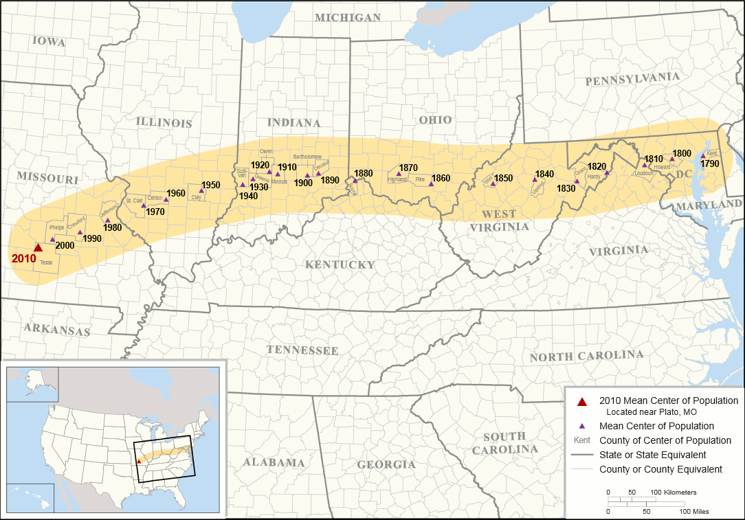
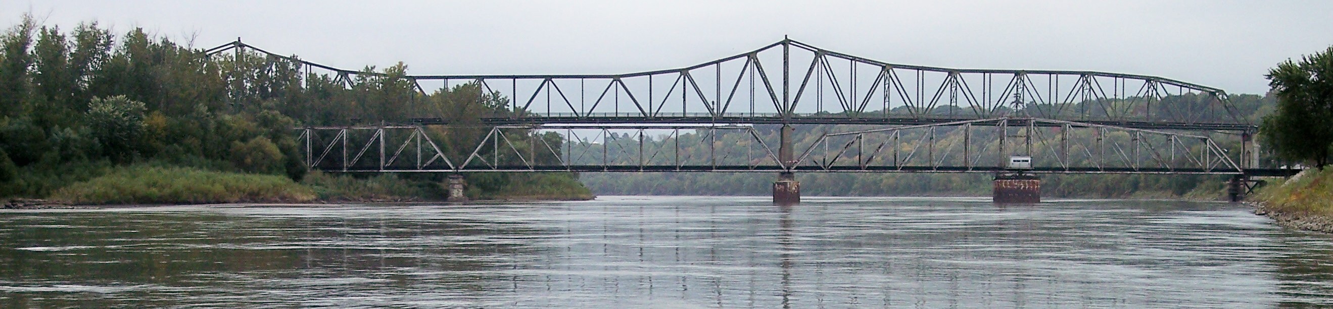
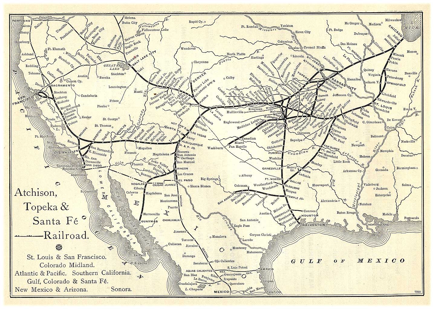
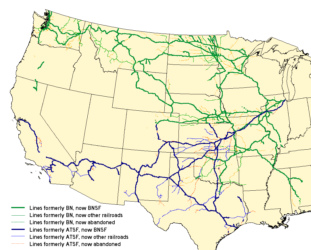
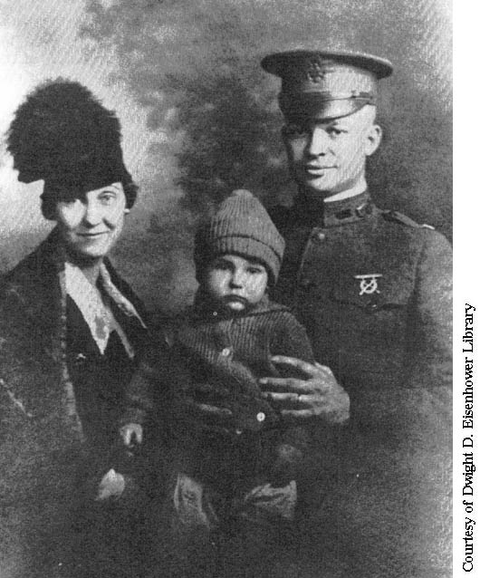
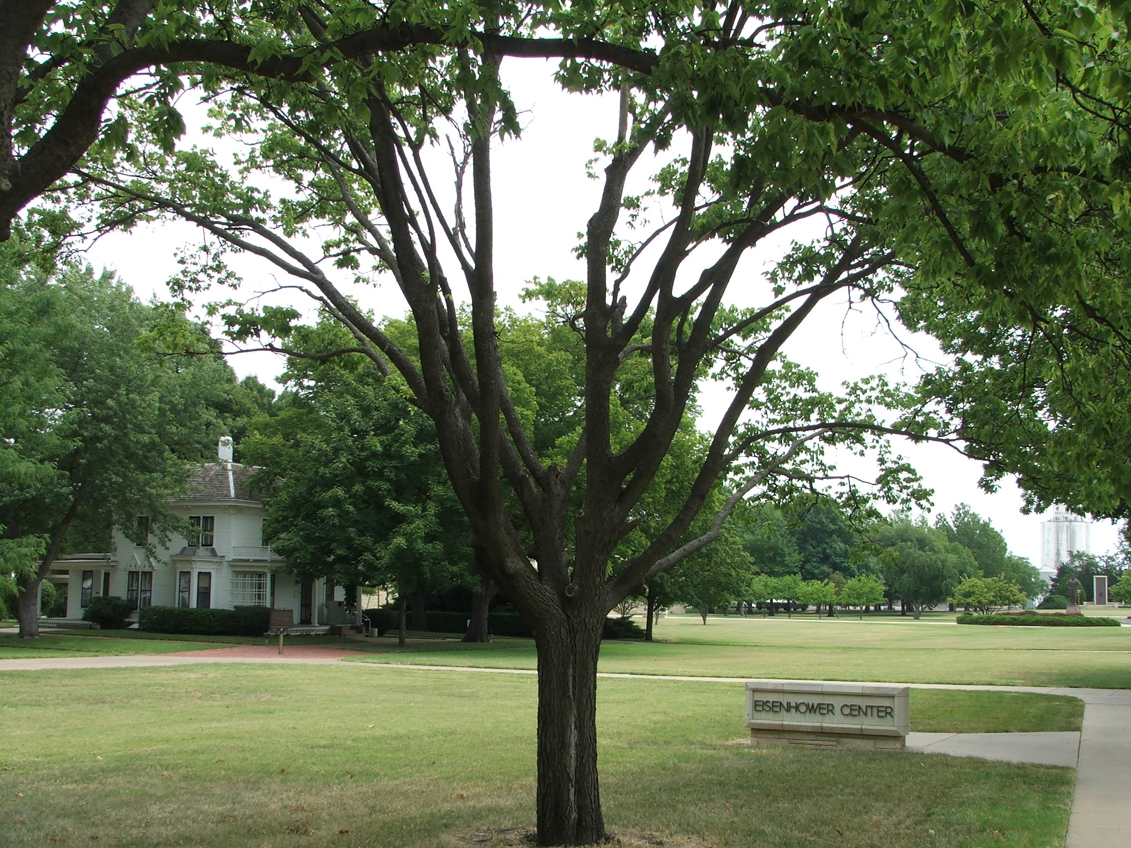
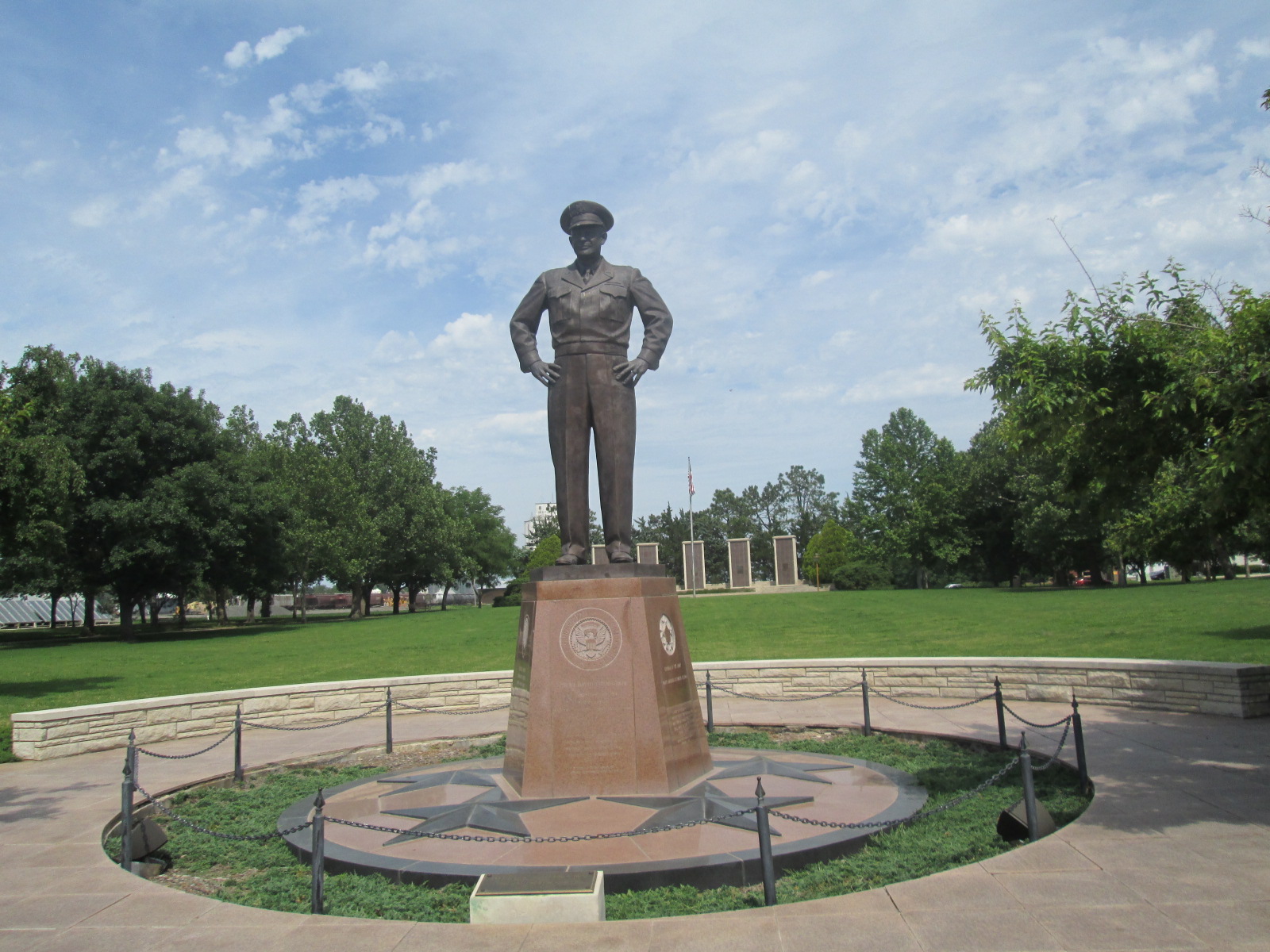
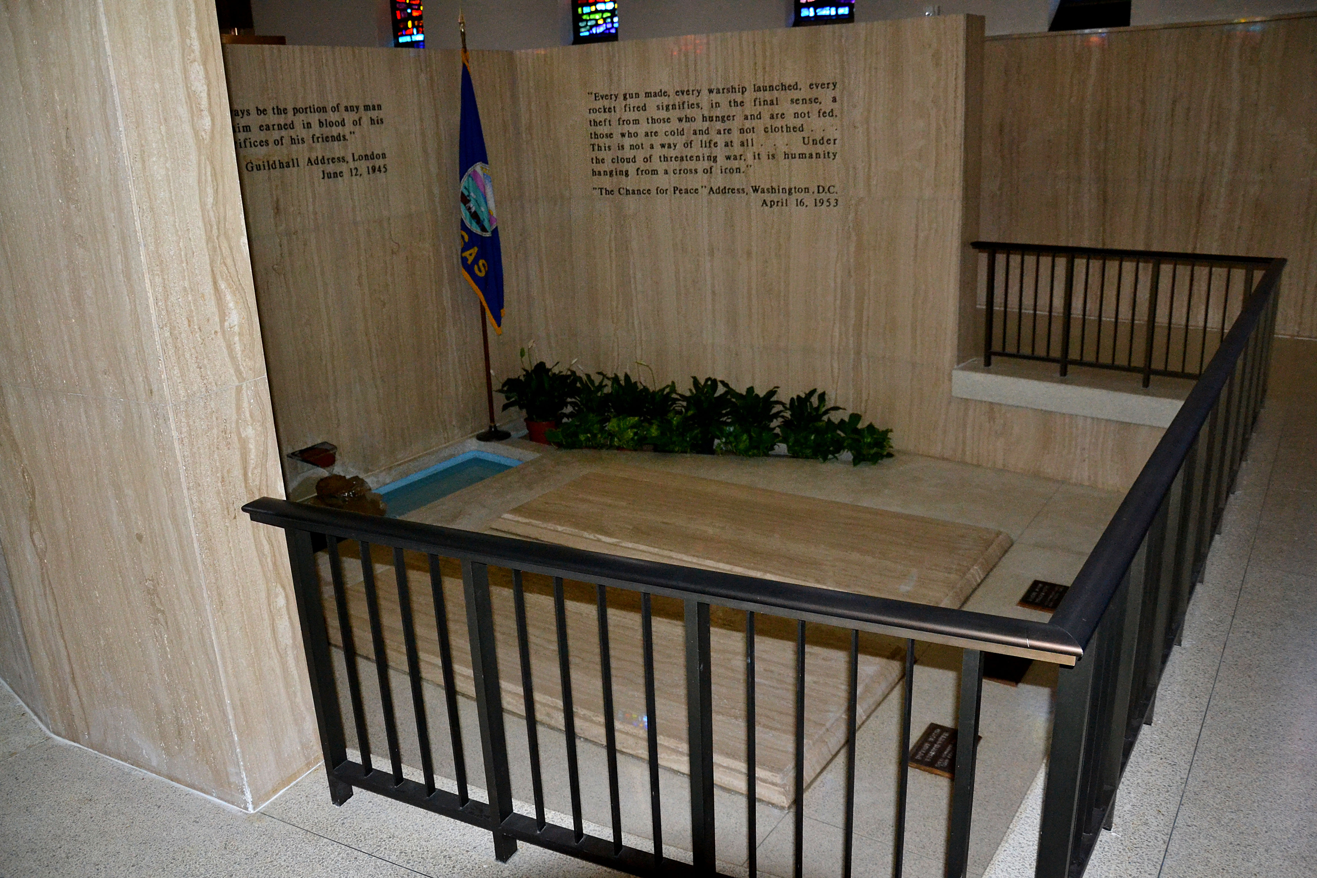
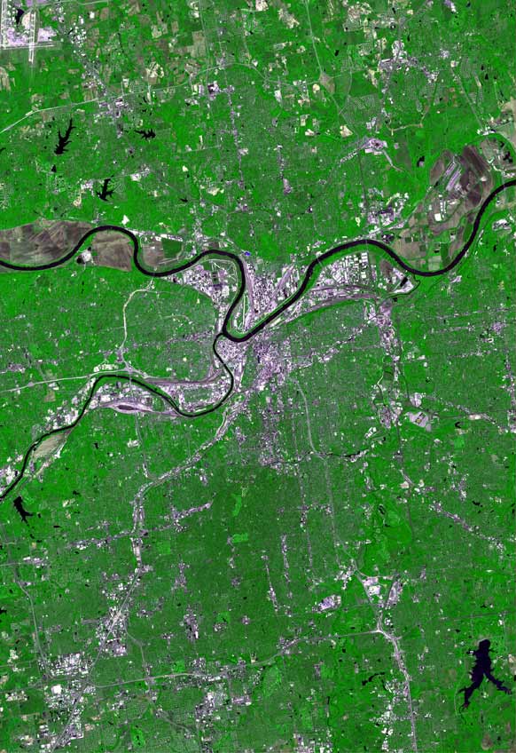
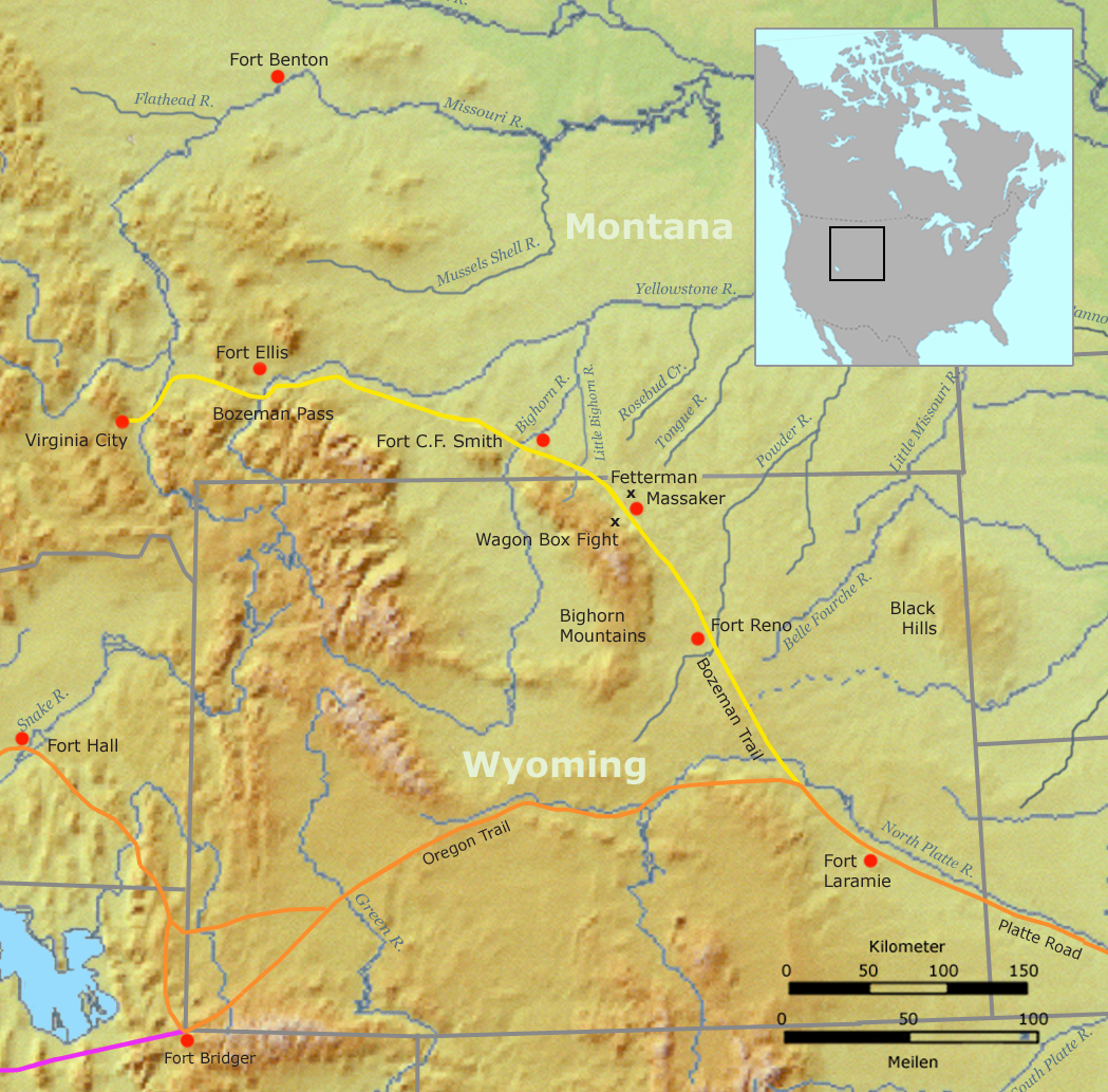
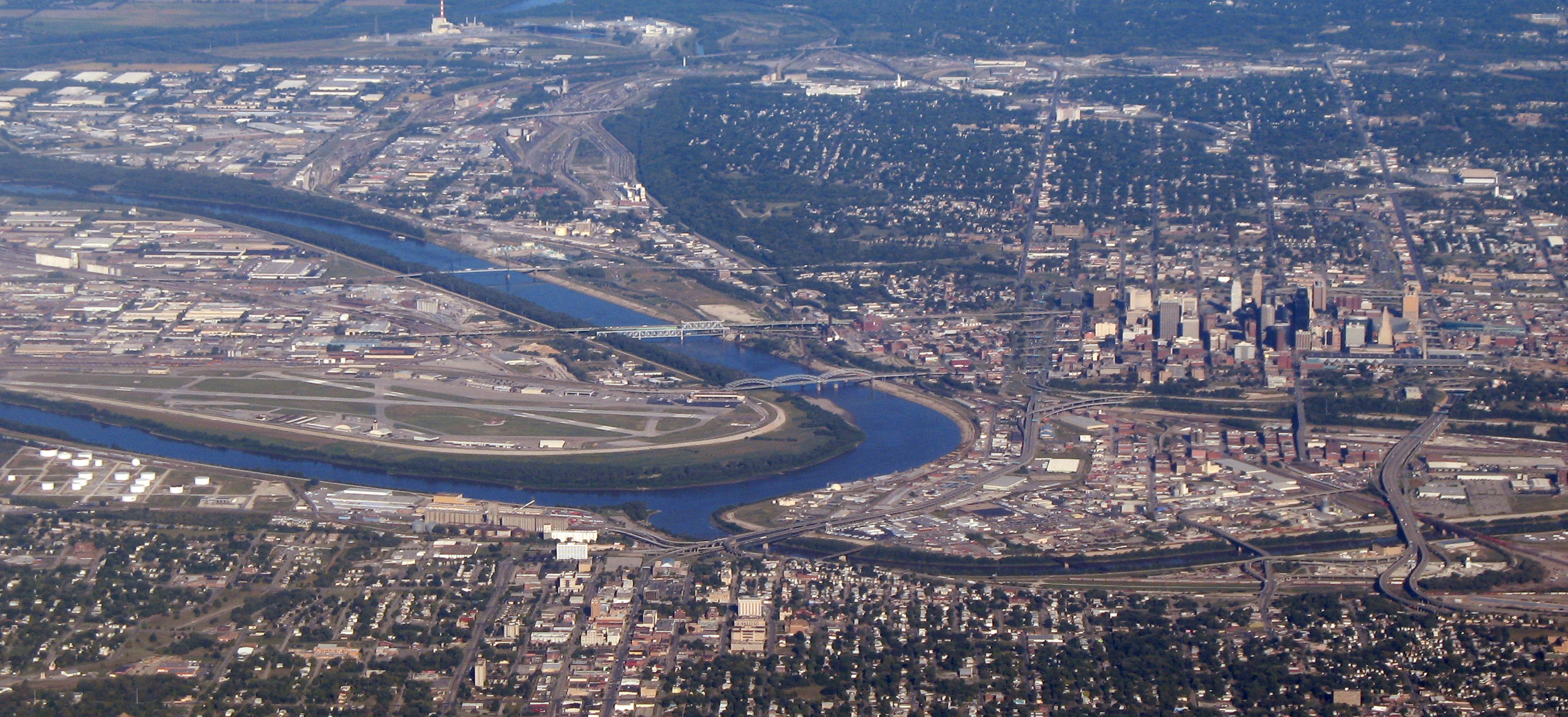
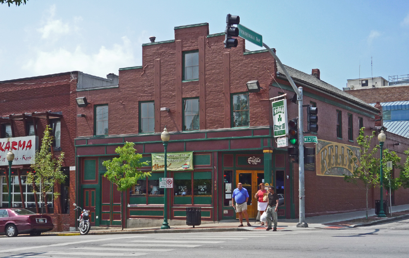
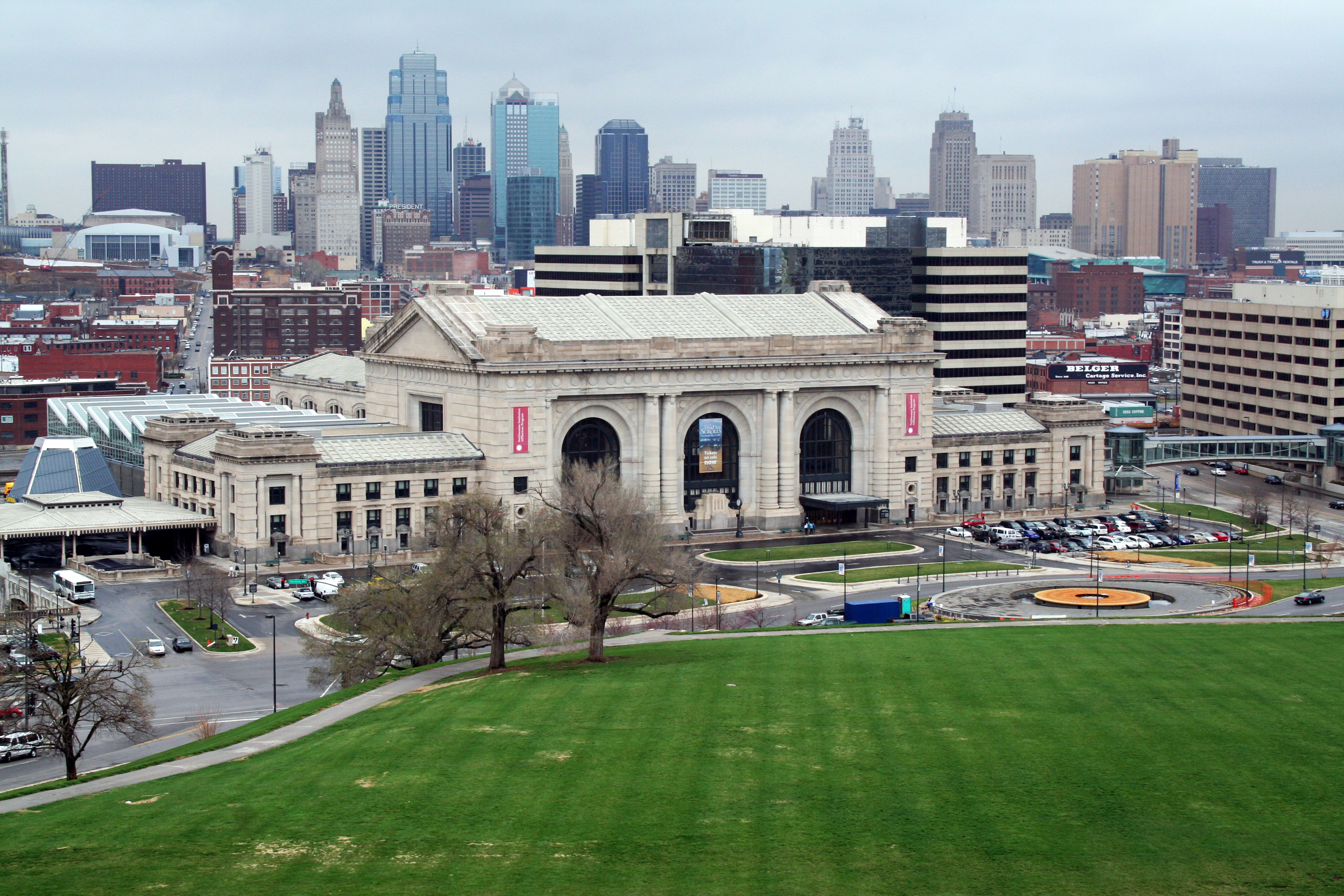
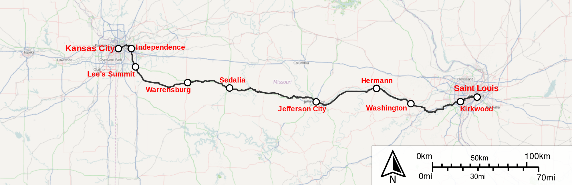