|
Reflections 2020
Series 9
October 11
Pandemic Travel I – Nights Away - World Trade Center I - Gravitas
| | Current Happenings This is a second tangent away from our ongoing narratives, but it is time-appropriate during the current pandemic and the recent 19th (!!) anniversary of Nine Eleven. After this we will return to Europe and the Orient-Express, and then the return to Florida will follow.
These tangential remarks are in a similar vein to the postings when I related about Nine Eleven originally, or gave a summary of how Hurricane Sandy affected the New York metropolitan region in 2012/22. And I note that both of the topics were written about as sudden interruptions to ongoing story lines, so this present interruption is not unprecedented.
| | | | Pandemic In no way need we repeat what we all already know about the seriousness of the Covid-19 pandemic, the quarantining in place, medical emergencies, the financial losses, the joblessness, remote learning, small businesses closing, restaurants serving outdoors, if not closing permanently, Broadway closed (!!!), San Gennaro not taking place (2019/15), Macy's Thanksgiving Day Parade being virtual, New Year's Eve in Times Square being virtual, social distancing, sanitizing of subways and buses, facemasks, and so much more. The year 2020 will go down as one to remember of great disruptions. Even the name Covid-19 laughs at us—it uses "19" because it started in Wuhan in December 2019, tho everyone associates it with the year 2020, and will surely continue to do so. | | | | Pandemic Travel Before things really got out of hand, I had a friend I last heard from stranded in Johannesburg, with no contact since. I have other friends who had just returned from Europe before the doors closed on simple reentry to the US. During the pandemic, I have friends who have been traveling by Amtrak in the region, and report that the trains are empty, so that there's no problem with social distancing, but Amtrak's hurting. I have friends who went to Italy in August, since she has family there. So I know some people who are moving about. But often, they're staying privately, rather than in hotels.
Most travel includes a degree of sightseeing, plus hotel and restaurant stays. But museums have been closed, other venues unavailable, hotels and cruise lines are panicked, and restaurants are languishing. We will touch very lightly on my local experience during the pandemic—which really seems quite trivial, but it's what I know best--then end up taking the shortest (one-night) overnight trip I can ever recall taking, shorter than a weekend away, which will functionally count for my only night away from home for the entire year 2020. Since this mini-trip involves travel within the World Trade Center complex, it's time I long last gave an update of that as well, including my opinions on the subject as a local resident, which I know—caveat--not everyone will share.
| | | | Travel Cancellation The only trip I've ever mentioned as being canceled until now was the Cuba cruise scheduled for last November (2019/18), which was replaced by the Florida trip that I enjoyed so very much more, and which we'll eventually finish discussing! Other than that, in recent years, I've been taking two trips a year, usually one early, one late, to avoid the summer rush. For July this year, I'd had a 22-night extended Great Lakes cruise scheduled with Blount, the same company I went from Montreal along the Erie Canal to NYC in 2017 (2017/5 ff). Not only did I schedule the same ship, the Grande Mariner, I even got to reserve the same cabin. I'd met Will Van Dorp, the ship's lecturer on that cruise, and he was going to see if he could work the same trip, so we could travel together once again. Before we sailed out of Chicago for NYC, I'd planned a pre-trip in Wisconsin and Michigan, including meeting up with friends—Carole is a first cousin of Beverly's. But when the pandemic started, it seemed wise to postpone it for a year to next July. I got my deposit back from Blount, all my points back from Amtrak, and canceled any hotel reservations. Only United Airlines, who I'd planned a small hop with in the Midwest, wouldn't refund my payment, but instead gave me a voucher good for two years. You now know what I think of United. In addition, Will found out that, while Blount's boatyard business in Rhode Island is surviving, Blount has put both its ships up for sale. So the reams of online notes, pictures, and maps I have are languishing, and the thought of taking that trip in July 2021 is dimming. It could end up being the second trip of note, after Cuba, being canceled.
But when not traveling, I'm frequently home, writing, planning trips, holding a Maifest and Oktoberfest for friends, and going out to dinner with a circle of friends. But 2020 has been a fest-less year, Easter dinner with family was canceled, and it's very likely Thanksgiving and Christmas gatherings will be as well. A family wedding planned for August was moved to next August. It goes on and on.
For quite a while I was only going out to grocery shop and to the pharmacy. Only recently did I start to catch up on missed doctor and dentist appointments. While packages have always been held for pickup by the concierge desk downstairs in my building, as of the pandemic, the volume of packages has increased, so that the desk looks like a post office once FedEx and others arrive. Also, any to-the-door deliveries were canceled. Thus, every day I have to go down to the lobby for my NY Times, where a table is full of a sea of newspapers, also for the Wall Street Journal, a few for the Post, and some Asian ones. For the last three years, I've been getting a dinner delivery from local restaurants once a week. During the pandemic, I raised that to twice weekly, on the weekends. Now when the food arrives, the concierge calls me to come and pick it up. But I find it amusing that the delivery service also sends me an email that the food's arrived, to which the courier attaches a cell-phone picture of my bag sitting on a table in the lobby, as proof of delivery. I understand the thinking, but it seems so weird. In addition, I've started using a grocery delivery service, and my pharmacy delivers as well, so I have fewer reasons than ever to step out of the building. Also, to avoid contact, I continue to use my elbow or a house key to push elevator buttons to and from the lobby.
I understand that many have gotten cabin fever from the quarantining in place, but, while I sorely miss getting together with friends (other than via frequent emails) I do not mind at all the hermit life of staying at home, doing my writing and what I always do anyway.
And so it appeared that 2020 would be a year where I never spent a single night away from home. Let's take a look at the record that proceeds that.
| | | | Nights Away I'm known for assiduous record-keeping, such as highest train routes traveled, highest hotels, longest flights, number of voyages by water, and so on. I'll add now that I've kept a Nights Away log dating from 1961. Below are the years with the longest total nights away from home that came to 100 or more per year:
#1: 1961-2 – 308 (10.3 months) This is misleading, because it was our academic year studying in Mainz.
#2: 2008 – 185 (6.2 months) Mardi Gras & Louisiana, Africa-Switzerland, US Northwest & Hawaii; Dominican Republic. This is a year that, in retrospect, really does surprise me. Gone a whole half-year!
#3: 1971 – 140 (4.7 months) Also misleading, because this was the first half of our joint sabbatical, where we studied and traveled in Europe: France, Germany, Austria, SE Europe. We came home for the winter, then went back to Europe in 1972 for 81 nights (2.7 mo): NE Europe, Austria, plus our drive in our VW Beetle from Vienna into the Soviet Union, exiting into Helsinki.
#4: 2009 – 127 (4.2 months) Polynesia, including New Zealand; Cape Cod & Provincetown; Dominican Republic, Japan/Taiwan
#5: 2006 – 121 (4.0 months) Florida, Scandinavia & Finland, NE US, Dominican Republic/Minnesota; Chile/Easter Island/Antarctica.
#6: 2004 – 118 (3.9 months) on the Caronia around South America for 7 weeks; Prague/Budapest/Benelux (these were Beverly's last two trips); the Deutschland around the Caribbean (my first solo trip)
#7: 2007 – 109 (3.6 months) Copper Canyon/Mexico City, Portugal/Spain/England; SW US; Dominican Republic
#8: 2010 – 106 (3.5 months) Spring Lake, East Hampton, Fire Island, Atlantic City; Round-the-World by Air (Singapore/Thailand, Australia, Emirates)
#9: 2011 – 103 (3.4 months) Amazon cruise, New England Thrice, Churchill MB (polar bears).
Now that I'm putting all these numbers together, I'm a bit taken aback as to how much time has been away. But over the years I always thought the two longest times away were our two experiences living and studying abroad (beyond the two-week language study courses here and there): the academic year in Mainz—which was indeed the longest--and the full eight-week summer studying Spanish in Málaga in 1990, poignantly at the very end of our First Travel Cycle. But in 1990, we were away for 76 days (2.5 months), of which 58 days were in Málaga (1.9 months). I always picture our time living in Spain as the "second longest", but 1990 doesn't even come close to reaching the 100-night minimum for the above list.
The years 1975-1980, especially the summers, were extremely busy with doctoral studies at Middlebury. The most we did were short trips, if any, not far from Middlebury, and those years are not counted in these tallies.
I've just done an average of all the years thru 2020, excluding those six study years, and excluding all the above-numbered lengthy years. The remaining average of nights away comes to 47 per year, or 1.6 months.
The average of the most recent years, 2012 to 2019, excluding 2020, is 52 per year, or 1.7 months. This is pretty close to what I've been saying lately, two trips a year of about three weeks each.
While 2020 will hold the record for being just the one night away, I'm surprised to find that in 1997 we were away only four nights, the second lowest ever. But by the late '90's, Beverly had gotten her diagnosis of Pick's Disease, and I was extremely concerned and very wary of travel. But things perked up right away the next year, when we had 36 nights in 1998. Thus that was a part of our Second Travel Cycle of limited travel, all domestic (2000/1). From the above it's easy to see how our Third Travel Cycle from 2000 to 2020, blossomed forth considerably, not only thru Beverly's last four years, but since then as well for me. Until 2020.
| | | | Planning The 2020 Mini-Trip But how did 2020 turn from a potential 0 to even a 1? It started in mid-August when I was reviewing my freebies, my burgeoning hotel points and Amtrak points. Both were growing because they were not being used up for the canceled Great Lakes cruise, with new points coming in from credit cards. But those points don't expire, and I didn't want to waste them on some little local trip I didn't need, just to burn points. But since Marriott took over the Starwood program, they have something special in addition to points. Every year they give a free overnight certificate to any of their mid-level hotels, no questions asked, but with only one year's validity. The first one I got was last year, and I used that 2019 certificate for my first night in Miami, with points for the second (but we still haven't finished talking about that trip). But here it was, mid-August, and I had the 2020 certificate burning the proverbial hole in my pocket. And it was only valid until 1 May 2021. So the bottom line is, it was not wanting to lose a valuable freebie that got me going to try to change 2020 from 0 to 1 and avoid totally breaking my ongoing record.
I looked for Marriott mid-level hotels on Long Island, Connecticut, the Hudson Valley, New Jersey down to Atlantic City, anywhere local that I could reach quickly by train for one overnight. I even looked within Manhattan and elsewhere in NYC. But any hotels I found reachable by train were in places with nothing for me to do. Then I had an epiphany. Food! I love restaurants, especially ethnic ones, and during the pandemic I dined out (solo) several times, all while seeing some favorite venues closing permanently. Also, the topsy-turvy world of 2020, restaurant dining took place outside, café-style, along the curb, or on terraces built out into the street, with roofs or umbrellas.
| | | | | | To memorialize for posterity an image of restaurant dining outdoors, I'll interrupt here to temporarily jump ahead five weeks to cite the first time in eight months I finally got to dine out WITH FRIENDS. It was on 8 October 2020, when five of us finally gathered together for some good conversation along with dining as a group. While the weather had been warm, on that Thursday evening it had gotten chilly, but we held fast for our very enjoyable two-hour dinner outdoors. From the left are friends Ed, Simi, Vince, Dave, Leslie, all in jackets, all masked (and all bespectacled). As I emailed the group afterward, it was an evening during the ongoing pandemic to remember: good conversation; our own semi-private little street terrace (hut?); masks that normally you'd want to avoid when taking a picture, but in this case, it was the whole point; waitstaff looking both ways before crossing the bike lane; even the two instances of emergency vehicles passing us with flashing red lights and sirens were part of the special ambience. What's not to like? It's the times we live in. We asked the waitress to use Dave's phone for the shot, and she looked both ways before stepping into the well-used bike lane between the curb and our "terraced hut". How well-balanced and symmetrical the photo came out! On parting afterwards, we all did the new pandemic ritual of the elbow-bump. O tempora! O mores! But in these weird tempora, we have to put up with some strange mores. |
| | | | Now back to five weeks earlier. Ethnic restaurants are often best found in ethnic neighborhoods, but ethnic neighborhoods are a dying breed. Kleindeutschland in Manhattan was before my time, and long gone. Yorkville, also German, is charming today, but no longer German. Even Little Italy, famous for the San Gennaro festival, now has a minority of Italians and Italian-Americans, with people coming from elsewhere for its bakeries, restaurants, and the festival. Only Manhattan's Chinatown thrives, due to continued immigration.
Possibly my favorite cuisine is Portuguese. I've taken people I know to the wonderful Alfama restaurant, when it was in Greenwich Village. I got to know the two guys that ran it, and also enjoyed a special vintage port wine celebration there, and evenings of imported Fado singers. But it was priced out of the neighborhood, and then moved to the East 50's, where I also brought friends. But it finally went out of business a few years ago.
I never knew of a Portuguese enclave in Manhattan, but have visited the Ironbound neighborhood of nearby Newark, New Jersey, famously a Portuguese neighborhood. In the past, when I used to keep a car, Beverly and I drove there at least twice of an evening for dinner. And most recently, I very clearly remember my most recent visit, in 2014, six years ago.
It was another of those extended trips that took 30 nights by train, boat, car, and plane (and wasn’t the only trip that year). It was rail to Ontario to sail up the Rideau Canal to Ottawa, rail to Halifax, then extended drives in Nova Scotia and Prince Edward Island. On 15 June I flew from Halifax home, which brought me to Newark Airport. I'd been notified when traveling that, due to construction, the NJ Transit train I'd be taking from the airport via Newark Penn to New York Penn temporarily wasn't leaving from the airport for Manhattan. Instead, there was a shuttle bus from the airport to Newark Penn station in downtown Newark, where the NJT train to Manhattan could be caught. I saw this as a perfect opportunity to visit the Ironbound again, adjacent to Newark Penn, for a Portuguese meal before finishing my trip home, despite it being the end of a long trip and having my wheeled bag with me. In 2014/20 I wrote: Adjacent to Newark Penn is the multi-ethnic working-class neighborhood known by a marvelous name, the Ironbound, based on its location surrounded by rail lines. It's particularly known as a Portuguese enclave with many Portuguese restaurants, and I'd found online the Iberia restaurant, not far from the station, and had a Portuguese dinner there before continuing on to Manhattan.
I checked for mid-level Marriott hotels in Newark, and as usual, got a flutter of airport hotels, which I rarely or never have use for. But there was a very nice Element Hotel by Westin in adjacent Harrison NJ that seemed to foot the bill perfectly, since it abutted Harrison Station. Harrison faces the Ironbound, and could even be walkable to it. PATH out of the World Trade Center would take me to Harrison, and it also could continue to take me to Newark Penn, where I could walk down historic Ferry Street to a restaurant I'd found that I was interested in. I phoned them to make sure they were serving during the pandemic and had a full menu, and was a bit startled to find that not only were they serving, they had the dish I wanted, and he described where they were serving as "on our terrace". Terrace? What could that mean? But it sounded good. And no, I didn't need a reservation given current circumstances.
| | | | | | Another aside for a quick jump ahead. Now that I've already had my one night, I decided to take another look to see what I could find locally that was both worthwhile and near a train station to see if I could raise the 2020 number of nights away beyond 1. I found something perfect. In Rhinecliff NY, which dates from 1686, there's a charming place called the Rhinecliff Country Hotel, built in 1854, and located directly on the east bank of the Hudson. It's directly adjacent to Amtrak's Rhinecliff station, just steps away. Each room has a Hudson view, and the hotel is on the Historic Register. But their website says they're closed for the pandemic—I do hope not permanently. With cooler weather arriving, I doubt if they'd be ready to open still this year. Pity. It seems you just can't win. |
| | | | Back to reality. With the Ironbound trip, I now had the Where, but not the When. Surely I should try it before cooler weather arrived. Then it suddenly struck me—my birthday was the very next week. Since Labor Day is the first Monday in September, it can fall anywhere from on the 1st (my birthday) to the 7th. September 1st, 2019 fell on the Sunday of Labor Day weekend, and things were crazy. Friends Simi and Ed joined me for dinner at Le Rivage on Restaurant Row in Midtown. It was a great evening, with one exception. When choosing the restaurant, I hadn't considered the hordes of tourists that would be in the Times Square area over Labor Day Weekend. There was so much traffic that I was late arriving. My bus couldn't move with the traffic, and I had to get off and hoof it the last few blocks, still arriving late. And when the three of us left to get to Times Square subways, it was literally elbow-to-elbow tourists all the way, often requiring abandoning sidewalks and walking in the street. I've never seen Times Square as crowded as that. A great birthday dinner with friends, but in a frenetic atmosphere outside. Still, this year my birthday fell on a Tuesday, almost a week earlier and still in the summer. Not only wouldn't there be any crowds, there would be very few people around at all. | | | | | | I should also mention that last year nephew Greg and Rosemary shortly after my birthday had a family dinner at their house, and for dessert—and as a birthday cake--Greg had (laboriously) made a Медовик / Medovik, a multi-layered Ukrainian honey cake also popular in Russia and Belarus. It has numerous (hence, laborious) thin layers of cake with numerous layers of cream filling. This is an online generic slice of Medovik (Photo by Edinburgh blog) to show the layers (there can be many more layers still). And this is a Medovik Greg made earlier, for my Maifest 2019, which had a Slavic theme (Photo by Greg Olszewski). |
| | | | So in 2020, September 1 fell on the Tuesday before Labor Day weekend. Of course, Times Square in the pandemic wouldn't be crowded anyway, but it was a good excuse to take my "Birthday in the Ironbound" mini-trip in peace and quiet. I never planned a trip before only one week in advance. I told no one, and only wrote a circle of friends once I was away, on each of the two half-days. | | | | The 2020 One-Nighter Packing was certainly simple, just toiletries and my laptop in a small bag. Towards noon I left, picking up my Tuesday Times in the lobby. It was odd, not having to suspend it for the time away, as I'd pick up the Wednesday Times on my return.
I walk past the World Trade Center occasionally, since it isn't far, but I wanted to take the bus for the short hop. And that alone was a new experience. I'd ridden subways twice during the pandemic, and aside from masks and social distancing, the uncrowded subway cars, sanitized overnight nowadays, made for a normal ride. But buses were different. Since the pandemic started, all NYC buses had been fitted with a clear-plastic shower-curtain type of barrier separating the front one-third from the rest. Passengers entered by the rear door, and since there's no fare box there, rides were free, causing great financial loss to the MTA. Only the disabled or people with carts could use the front.
But as of the day before, Monday, August 31, things were going back to the more normal. The destination sign on the front of the bus varied between naming the destination, then saying "Masks Required", then "Fare Required". How odd, but how understandable. It was actually a bit weird for the bus to pull up and the driver to open the front door for me, not the rear door. I paid my fare, and the old barrier was gone. However, there was a larger see-thru barrier now around the driver. Signs of the times.
Our very short bus ride will take us to the World Trade Center (WTC), and to The Oculus, its transportation hub, in order for us to take the PATH train under the Hudson to nearby New Jersey. This is as good a time as any to discuss the WTC, which I talked about quite a bit almost two decades ago, but have rarely mentioned since. I find it easiest to look at it as two separate discussions, separated by Nine Eleven: WTC Before and WTC After. I find this is necessary since I suspect many can't look at the Before period dispassionately—they see it thru the veil of the tragedy, and—my guess—nostalgia enhances their memory of what it was at that time. So as I give my opinion of WTC Before, which is not very positive about the two oversized hulks, if yours is different, see if WTC After isn't influencing your memory.
| | | | WTC Before This period runs for two years short of four decades, from 1973 to 2011. I only just learned that there is a group called the World Trade Centers Association, founded in 1968, after the first one was established in New Orleans. Its purpose is the expansion of trade. As of May 2020, the WTCA included 323 properties licensed in 90 countries, of which NYC is one. As the 1970s approached, to help stimulate further development of Lower Manhattan, David Rockefeller suggested that the Port Authority build the New York World Trade Center there.
https://maps-manhattan.com/img/0/map-of-lower-manhattan.jpg
Use this "Moon" map as a guide. There were two choices at the time. The WTC was first planned for the east side of Lower Manhattan, in the area of South Street Seaport. I don't know where exactly, but assume it would have been between City Hall Park and South Street Seaport, close to the Brooklyn Bridge. This would have been the more horrendous of the two choices, given the historic seafaring neighborhoods in the Seaport, the Bridge, City Hall—I don't even want to begin to think about it.
But since the project was under a two-state agency, the Port Authority of NY and NJ, both states had to approve. NJ objected to the far distance to the East River, so the second alternative was chosen, also bad, but not as bad. The campus (my word) to be built would replace the area of the Hudson Terminal (opened 1909), which was the terminal for the Hudson & Manhattan Railroad ("Hudson" here refers to Hudson County NJ, directly across the river). Since the H&M was beginning to go into a decline due to the automobile tunnels and bridges crossing the river drawing off its customers, the Port Authority agreed to take over the H&M railroad and build the WTC around and behind the railroad's Hudson Terminal, which already included office towers. The Authority rebranded the H&M, using its own name, as the Port Authority Trans-Hudson, or PATH, which is how it's still known. Do keep in mind that PATH remains the basis for the location of the WTC.
If you've never fully followed what the WTC looked like before and after, we have a pair of maps to compare with each other. This first one we'll call the Before map (Map by MesserWoland). Since we'll need to refer back to it, here's the direct link to the SAME MAP so you can keep a copy in a separate window for ongoing reference:
https://upload.wikimedia.org/wikipedia/commons/thumb/1/1e/WTC_Building_Arrangement_and_Site_Plan.svg/1000px-WTC_Building_Arrangement_and_Site_Plan.svg.png
We'll get to the campus itself shortly. First, let's establish some parameters. Click to find Greenwich Street, which runs N-S inland a bit. This was roughly the original shoreline of Manhattan. In the 19C, landfill extended it to West Street, which was the shoreline for most of the 20C. So we immediately see that the campus is partially on landfill, or put differently, the western part of the campus was once part of the riverbed. West of West Street is Battery Park City (BPC) from the 1980s, extending the shoreline further still. BPC is residential, commercial, and retail, with lots of parkland. My building (not shown) is located on this map under the compass rose at the southwest corner of South End Avenue and West Thames Street. Let's clarify that nothing in BPC is or was ever part of the WTC complex, but areas near it nevertheless were damaged in Nine Eleven. In this regard, we should discuss the WFC and Winter Garden.
| | | | World Financial Center The buildings you see on the map marked WFC comprise the office building area of BPC, facing the WTC. While I don't find them particularly distinguished in style, they are rather decent, mid-sized buildings that form an attractive part of the community. Their original name, the World Financial Center, was clearly a copy-cat name taken from the WTC (isn't all of Lower Manhattan a financial center?). However, after Nine Eleven, the office buildings were taken over and rebranded as Brookfield Place. I do hope you aren't attracted to that namby-pamby name. It's too cutesy even for a suburban mall, with has no brook, no field, and no street or square called a place. Transfer that to Manhattan, and it makes even less sense. Thus the complex is still locally referred to as the WFC.
It's just part of the neighborhood. At the upper end of South End Avenue, where you see the circle, I enter the building to go to my Rite-Aid Pharmacy. If we walk a little further, we come to the major asset of the WFC, the Winter Garden Atrium (see map). Now let's look at some pictures. Here we have an aerial view to the east, including the East River, showing the oversized Twin Towers shamelessly overwhelming the WFC. It shows as well as any picture how out of step the towers were with the skyline. The WFC buildings in the foreground, some with green roofs, many with setbacks, show at least a bit of personality. Under the lower circular green roof you see the circle at the upper end of South End Avenue, and at the far end of that building, you cannot miss the black arched roof of the Winter Garden Atrium, with its outdoor café seating in warm weather at the mini-harbor of North Cove. On the Hudson is the floating dock of the BPC Ferry Terminal. Behind the Winter Garden you see the former North Bridge crossing West Street to connect with the WFC. I include this "after" picture now of the WFC in 2011 (Photo by Paulm27), with the Twin Towers gone and the new One WTC only partially built behind the WFC. This is a more uniform skyline, not being overwhelmed.
But the showcase of the WFC and a credit to the local community is surely the Winter Garden Atrium (Photo by WiNG), usually just called the Winter Garden. It's a domed pavilion built in 1988 and is shown here in 2007 after being rebuilt in 2002 following serious Nine Eleven damage. In this eastward view, click to see the seating below the live palm trees and the magnificent marble Grand Staircase, concave at the top and convex at the bottom. I've seen bridal parties take photos on the staircase. The staircase had a practical purpose when the former North Bridge coming from the WTC led into it at the top. Now it's just serves as an attractive backdrop.
Here we have the westward view down the Grand Staircase (Photo by Arild Vågen). Click to see the palm trees, outdoor café seating, and even the Hudson. The concave upper stairs are clearly visible; the circular area includes the convex part. This is the reverse view showing the riverfront façade with the outdoor cafés (Photo by Jill Clardy).
Here we have the West Street façade of the Winter Garden on 27 September 2001, almost a month after Nine Eleven, showing the major structural damage to its glass-and-steel frame. Reconstruction required 2,000 panes of glass, 5,400 sq m (60,000 sq ft) of marble flooring and stairs, and sixteen 12 m (40 ft) Washingtonia robusta palm trees at a cost of $50 million. The entrance from the former pedestrian North Bridge was replaced by windows facing West Street. I remember reading of the eagerness to make the Winter Garden the first structure to have a comeback. Quarries in Italy produced stone matching the original, and Italian stonemasons were flown in to do the repairs. Thus the Winter Garden reopened on 11 September 2002, just over one year after the destruction. Finally, this is holiday time 2006 on the Grand Staircase (No Attribution).
| | | | Ex-Hudson Waterfront Now let's go back across West Street to the original WTC campus, which lies at the southern end of Tribeca as it borders the northwestern end of the Financial District. Our Before map shows it as a quadrilateral trying to pass itself off as a square. In addition, the developers grabbed a bit of an annex to the north, sort of adding a "chimney" to the "roof". And to put this campus together, the City disrespected the neighborhood and closed quite a number of old streets. But while we're on the subject, look at the bottom of the map and note how the exit ramps from the Brooklyn-Battery Tunnel (BBT) also disfigured the neighborhood. In order to see what neighborhood we're talking about, I have to make up a new name below (I do that a lot--"campus" was the most recent).
https://www.nyctourist.com/images/historic/maps/new_york_city_lower_manhattan_rider_1916.jpg
This is a 1916 map of Lower Manhattan. Look at the elevated trains meeting in Battery Park! They're all gone now. To the east, up Pearl Street ran the 3rd Avenue El; to the west, the 9th Avenue El ran up Greenwich Street, and the 6th Avenue El ran up Trinity Place/Church Street. West Street, as we know, was the shoreline of the Hudson, and we see all the piers that used to be where BPC is today.
But I call your attention to the waterfront blocks from West to Washington to Greenwich to Trinity Pl/Church St, and then from Battery Park up to Vesey and Barclay Streets. Since no name exists for this long rectangle, I'll call it the Financial District's ex-Hudson Waterfront. On the other hand, check out this version of that last map:
http://www.boweryboyshistory.com/wp-content/uploads/2015/11/LS_postcard_front-1.jpg
It designates Little Syria, centering on Washington Street (click), as being just slightly smaller than the ex-Hudson Waterfront area we're discussing, but keep both in mind. Now compare these long rectangles to our Before map as we discuss a few of those streets whose names will come up again later.
Morris Street (see "Moon" map), once only three blocks long, has lost its middle block because of the exit from the BBT. Its remnants are two small disconnected blocks that don't even seem to belong together any more. Rector Street fortunately remains intact. Cedar Street, one block from the WTC, has lost several of its blocks. Liberty Street is now the southern border of the campus. Cortlandt, Dey, and Fulton Streets have lost major sections. Vesey Street is now the northern border of the campus, with the "chimney" running up to Barclay.
Church Street is now the eastern border of the campus, while West remains the western border. But Greenwich and Washington Streets have lost major sections. Note both seven-year-old Hudson Terminal Buildings on Church Street (PATH now is pulled back a block to Greenwich Street). The two were connected by bridges over Dey Street, since the City would not allow Dey Street to be closed to unite the two buildings, quite an ironic difference from that time to all the street closings that the campus took decades later.
| | | | | | Of all the streets closed, two in particular are particularly poignant. Fulton Street had been the only street in Lower Manhattan that had run river-to-river, and here they cut off its western end. Greenwich Street is even older. It had been the country road that had connected the nascent city at the southern tip of the island up to Greenwich Village, and it too was decimated. However, there's good news. After Nine Eleven, Greenwich Street was rebuilt, and Fulton Street was as well (up to BPC), tho as a pedestrian street. Even the block of Cortlandt Street came back, between Church and Greenwich, but that block, too, is for pedestrians only, and is called Cortlandt Way. But pedestrian streets are Good Things.
Let's bring up a language issue. How do you pronounce Vesey and Dey Streets? Be careful, they're traps. Full disclosure: I've mispronounced them for decades, and I live here! I always rhymed them, respectively, with "messy" and "day", but since researching all this, I've reformed.
Vesey Street sounds like VI.zi, or like saying the letters V-Z. William Vesey was the first rector of nearby Trinity Church.
Dey Street rhymes with "dye". It was named for colonial-era Dutch farmer, Dirck Teunis Dey--the road/street was built thru his former property en route westward to a ferry on West Street.
So let's not disrespect these two venerable gentlemen by mispronouncing their names!
|
| | | | Little Syria Now we needn't go back to the 17C and 18C to talk about the history in this area. We can allow Mr Dey and Mr Vesey to represent those times. But throughout the 19C and early 20C, specifically the six decades from the 1880s to the 1940s, our "ex-Hudson Waterfront", especially the southern part of it, was known as Little Syria, particularly Washington Street from Battery Park to above Rector. It was inhabited by a panoply of working-class immigrants from the Eastern Mediterranean, many of whom were Christian Arabs from Syria and Lebanon—hence the name--but the area also included Greeks, Turks, Armenians, Iraqis, Palestinians, and other ethnic groups, such as Slovaks, Poles, Hungarians, Lithuanians, Ukrainians, Czechs, and Irish. Little Syria declined as successful residents moved away, notably to the Arab neighborhood of western Atlantic Avenue in Brooklyn, but it disappeared almost entirely when much of the area was demolished to make way for the entrance and exit ramps of the Brooklyn-Battery Tunnel, which opened in 1950.
We'll have more to say about the loss of ethnicity in the ex-Hudson Waterfront when we talk shortly about Saint George's Syrian Catholic Church in the lower end of the area and the Saint Nicholas Greek Orthodox Church only a block from the WTC campus and the saga of its tragic history. Modern developments have not treated this neighborhood kindly.
| | | | The Campus As a teenager living in Queens, I frequently took the subway into Manhattan to roam the streets, learn about the neighborhoods, visit museums, and get comfortable with the geography. I sometimes did this alone, other times with my cousin Gary or with friends. Lower Manhattan always intrigued me most because of its history—it's where the city started. The first half of 1961, before the academic year abroad in Mainz, I worked as a clerk in a brokerage house on Wall Street at William, and the year after Mainz, 1962-1963, I worked as a translator on Lower Broadway. This background has always given me a particularly strong interest in the area, which is why Beverly and I eventually moved here in 1995.
Now the core complex at the campus was built between 1966 and 1975, and I was concerned that something so massive was taking over more than a dozen city blocks of an older neighborhood. True, it was largely a warehouse district, but aside from the ethnic question, these blocks included what was New York City's Radio Row, with shops specializing in radios and electronics. It existed from 1921 to—what else--1966.
And many others objected. The project was seen as being monolithic and overambitious, with the campus superblock replacing a more traditional dense neighborhood making it an inhospitable environment. It was referred to as "purposeless gigantism". Property owners, small businesses, and about 100 residents fiercely resisted the project. Some small businesses sought an injunction challenging the Port Authority's power of eminent domain, but it failed. Even private real estate developers felt that so much new "subsidized" office space, competing with the private sector, would create a glut on the market. From my point of view, I felt it was bad enough to build upon an oversized, unadorned angular box. But then it was compounded with the Twin Towers by building TWO of them!
But my favorite objection was the esthetic issue. The American Institute of Architects and other groups criticized the design of the project. Many disliked the Twin Towers' narrow windows, only 46 cm (18 in) wide, and framed by the numerous ribs that typified the buildings' outer design, since this restricted the view to a narrow slot. It was felt that this reflected the architect's fear of height, since he felt narrow windows would make workers feel more secure. But my favorite observation as to the design was the "dig" made by the reporter who said the Twin Towers looked similar to the boxes that the Empire State Building and Chrysler Building came in". Woo-ee! That hits the spot.
Let's take a look at an aerial view taken in March 2001 of the Twin Towers (Photo by Jeffmock). 1 WTC, the North Tower, is at the left and 2 WTC, the South Tower is at the right. Note how their oversized hulk overwhelms the more conventional WFC, with the several green roofs. Click to inspect their surface closely, and you'll won't be able to see any windows between those ribs—check out the windows in adjacent buildings as a comparison. And talk about a boxy, square-topped design, with no personality whatsoever. In which of these two packing crates would you say the Empire State came in, and which the Chrysler?
At the time of their completion, they were the tallest buildings in the world. The North Tower was a bit taller at 417 m (1,368 ft), and the South Tower was 415.1 m (1,362 ft). And there's no doubt that to many, they had become an icon. But they HAD to have become an icon, shown in numerous skyline pictures, whether they were liked or not, since they stood out so blatantly above the "normal" skyline, as this link shows:
https://garystravel.files.wordpress.com/2011/02/twin-towers.jpg
Return to our Before map. You see 1 and 2, the towers. The others I found of little appeal, just mundane, lower buildings. Particularly irksome to me was WTC 3, originally the Vista Hotel, but later the Marriott WTC. To its credit, it was the first hotel to open in Lower Manhattan south of Canal Street since 1836, and I respect that as a positive move forward. But to its detriment in my opinion, its serpentine shape effectively closed off any view from the Plaza toward West Street and the WFC, as well as the Great Wall of China would have done.
But once we moved here in 1995, a quarter-century ago, this became our neighborhood. Look north of Vesey at the large, well-known Church Street Station of the US Post Office. Early on we'd go there regularly for stamps and to mail packages (now there's a closer PO). And also note the Verizon building. On Nine Eleven, we lost electricity immediately, but had phone service for quite a while still, so we could keep in contact with family and friends. But it was only when falling debris eventually hit that Verizon Building did we definitively lose phone service.
And we regularly used the WTC Mall that stretched beneath the complete campus, even tho it wasn't particularly unique and seemed somewhat crowded. I remember walking thru its corridors was like walking thru a basement. I clearly remember three locations. We bought greeting cards at the Hallmark store at the lower right; at the upper center, we opened the Schwab investment account I still use today at the Charles Schwab office; and the apartment keys in my pocket today were made at the shop which I now see was named Daniel Pehr Locksmith. (On a whim, I just looked up his name. Assuming it's the same one, he seems to have relocated his locksmith business to Floral Park on Long Island.)
And we used those two access points: in WTC 2 (South Tower) to the viewing platform up top (Photo by TedQuackenbush)—this is a north view in 1984 including the Empire State Building and George Washington Bridge--and in WTC 1 (North Tower) to the Windows on the World Restaurant on the 107th floor (Photo by User:Raphael.concorde). Beverly and I dined there I think three times, once taking my mother on either Mother's Day or her birthday. And one memory is this: we once got a phone call and were asked to step outside on our back breezeway and look up. My sister Pat and her late husband John who were dining there and looking down at us as we spoke on the phone.
We also would spend time in good weather in the WTC Plaza above the mall (Photo by zombieite), but it's obvious how that Marriott Hotel (WTC 3) hemmed in the area and blocked any decent westward view. Click to see how the only decorative feature of the towers below those monotonous ribs was at the bottom, where they spread apart to resemble a Gothic arch in what is called the "Gothic modernist" style, and note again how you can hardly see any windows in the Twin Towers above these "arches". Here's a closer look (Photo by Rainer Halama), similar to one I once got when I walked very close to one tower and looked straight up. And from the Plaza those towers were even more overbearing than anywhere else, continuing to exemplify their "purposeless gigantism" (Photo by Karl Döringer).
From what I've been saying you can tell I like my neighborhood, and regret what real estate developers did to it back in the day, so what I've said so far have been "downer" comments. Now it gets worse, seeing what terrorists did to the area. Finally, in the After section, we'll have some very interesting positive comments to make about the reconstruction.
| | | | Nine Eleven I have absolutely no intention of reviewing facts we all know about the terrorist attack. But on the personal side, I've just skimmed a bit from the postings on Nine Eleven, 2001/11-12-13-14-15, with an epilog at the beginning of 2002/1. It's really quite complete and informative, including how we held out for two days in our present Regatta condo with no power before being evacuated; my being interviewed for a newspaper article; and how four members of the building staff carried Beverly in her wheelchair down six flights while I carried our wheeled bag. From the parts I reviewed, there were numerous facts I don't remember, so it's just as well they're well documented for the record, which is another reason I'm doing this updated posting.
https://legacy.lib.utexas.edu/maps/historical/wtc_p200003-1.jpg
But we can add some illustrations. The above image showing the attack is turned around, looking southwest, but it shows the two crash areas, and also how much bigger the Twin Towers were than the other WTC buildings. You see the Post Office and Verizon Building, and the former North Bridge leading to the Winter Garden in the WFC. You can barely see the Saint Nicholas Greek Orthodox Church, which we'll have a lot more to say about later.
At the highest point of the image you can see the footprint of my building the Regatta, at West Thames and South End. On Google Maps, I just measured the distance from the bottom of the south tower to my building, which came to about 446 m (1,463 ft). The height of the south tower was 415 m (1,362 ft). That's 93% of the distance. In the unlikely event it had fallen sideways, and specifically in my direction, that would have been much too close for comfort.
But fortunately, that couldn't have happened. While not going into details, as I see it, there were actually two horrific events that took place, one right after the other, first the fire, and the collapse. The fire primarily burned the area above the impact. Tall buildings are built to (at least barely) survive a fire. But the burning jet fuel ran down the interior girders and that high temperature weakened the steel on the first floors below the fire. When they no longer could support the burning upper floors, the upper floors pancaked down thru them, and action that then continued like dominoes thru the rest of the buildings. Thus the horrific damage and loss of life was contained within and immediately around the campus. The buildings could never have tipped over, because to do so, the weakness would have had to have been at the base, which was not the case.
| | | | | | There's one more hypothetical I should add here for full disclosure. Before we moved into the Regatta, we made a down payment at the Tribeca Tower on Duane Street just west of Broadway (see "Tribeca" on the Moon map). But the condos weren't selling and our down payment was returned, because the building was instead going to be a rental building, which it still is.
But the apartment we were planning on was on the top floor, the 52nd, with both Hudson and downtown views. Now here's the hypothetical. I have no reason whatsoever to believe that Tribeca Tower lost power, including to its elevators, during Nine Eleven. After all, it's 1½ times the distance north of the WTC (see map) than the Regatta is south. But not only would the Tribeca Tower definitely have had an even more horrendous view of Nine Eleven than I had from the Regatta, but what if hypothetically the power and elevators had failed? How would I have gotten Beverly in her wheelchair down 52 flights? That's why, after Nine Eleven, I'm opposed to any overly tall buildings, especially for residences.
|
| | | | Since we're now all familiar with the looks and layout of the campus, which in this time period was called Ground Zero, this partial view of the destroyed WTC site should be understandable, especially since it has an overlay of the original building locations. Liberty and West Streets are shown, and we can see one of the round green roofs in the WFC.
https://legacy.lib.utexas.edu/maps/historical/wtc_p200009-1.jpg
While that picture was more dramatic, this image is more instructional. Click to see that, in black, the Twin Towers and (crowded-in) Marriott Hotel, along with the North Bridge, suffered total collapse, as did WTC 7 up in the "chimney". The three other buildings in brown suffered partial collapse, and were removed, which means that NO original buildings of the WTC remain whatsoever. It's hard to tell, but tiny St Nick's is also in black (more later). Of the buildings in blue that received major damage, I can speak to the Art Deco Verizon building, which was restored at great expense, and as we know, the WFC, and most notably, the Winter Garden, are nicely restored.
| | | | | | I've asked others on occasion contribute to these postings, such as with the recent solstice, and the Gold Spike Anniversary. But this time, the contribution is a first. Sue Binkley Tatum, PhD, is an artist in Aspen, Colorado. She's also on my mailing list, tho I've never met her, as is the case for quite a number of followers. She occasionally writes, and recently when I said I was going to update the discussion of Nine Eleven, she sent me online a copy of one of the pictures she did in 2001 at the time of Nine Eleven. I posted it on my Flickr account, to include as her contribution here. This is Sue's Ghost Towers. She tells me it's 8x10 in (20x25 cm), and is obviously a watercolor, which I believe properly captures the subject. I don't know if you can tell, but, while we've looked at several pictures of the Twin Towers looking east from the Hudson, Sue's view looks west, from the East River, and includes the Brooklyn Bridge. I find Sue's watercolor a proper way to close the section on Nine Eleven. |
| | | | WTC After As I reviewed older postings, I found I did continue with some updates at first, for three years. 2002/7 has a section called "Nine Eleven Plus One" with additional information, and 2003/14 has one called "Nine Eleven Plus Two". But perhaps most surprising to many will be the event described in 2004/3 called "Visiting Ground Zero". My niece's (now ex-)husband Joe at the time was working on the rail part of the reconstruction, the PATH train that we'll be taking on the mini-trip, and he knew I lived nearby. So just before Christmas 2003, he invited me to go down into the "bathtub"—the pit-like construction site being worked on three years after the attack, as it had been during the original construction. When I met him at the site, he got me a visitor's pass and a hard hat, and told me he was calling me a "consultant". (HA!) We went down about six stories to the bottom—under open skies--and I could see the slurry wall—the "bathtub" that keeps the Hudson out. The PATH trains, now underground but their tunnels exposed then, came in from one Hudson tube (tunnel) made a loop at the station, then left via the other tunnel. As I wrote: I now found out that the train line was . . . lowered considerably at that point, so that if you look up on the east [inland] slurry wall, you see huge openings where the cut off [section of the rail] tunnel area is. We went up to this "left-over" piece of tunnel, which is now used as a loading dock for truck deliveries.
I do believe I've had more than average experience with the events of Nine Eleven, having observed the fire and collapse, and later having driven past the destroyed section of the Pentagon on the way to Florida. In addition, I was down in the re-exposed pit three years after the event. Anyway, that was the last of the early updates, until now.
| | | | Original Bathtub The best way to try to explain the experience of being in the bathtub in 2003 is to discuss its 1966 construction under the western half of the campus between Greenwich and West Streets, since that was the landfill area, with actual bedrock located 65 m (213 ft) below the surface. Because of groundwater seepage, and even more so, because the Hudson was so close (the landfill area had been the bed of the Hudson), a new method was used to construct a slurry wall to keep out water. A slurry wall is a civil engineering technique where a reinforced concrete wall is built underground around a construction site to hold back water. The slurry wall in the WTC site has typically been referred to as the bathtub, but this is confusing, since a normal bathtub holds water IN, while this structure holds water OUT. When you're down in the bathtub, it's like walking in a huge roofless cube, totally open to the skies.
But an added complication was that the original Hudson Tubes (PATH trains) remained in service as elevated tunnels on trestles running east-west. Somewhat precariously, one subway line, the 1, which I use most frequently, runs north-south right up Greenwich Street. That street was closed and the piece of subway beneath it completely destroyed, but by 2002, a temporary structure allowed it to continue running. But it was immediately outside the bathtub, so it wasn't as much of a problem.
We'll now see two pictures taken in 1969 during ORIGINAL construction. But I'm talking about my 2003 visit, so the scene will be similar, except of course the girders for the Twin Towers were gone. This picture looks northeast and shows the bathtub running along the west side of Greenwich Street, which means the 1 line is behind the wall. The frame of the South Tower are shown, so "unsee" it. The curious structure in the center is the eastbound PATH tunnel elevated on a trestle penetrating the slurry wall/bathtub as it heads into Cortlandt Street. (One more update: as mentioned above when I was there, the PATH line was being lowered, and only an opening in the wall remains today, used as the aforementioned loading dock.)
This 1969 view looks northwest and again shows the PATH eastbound tunnel on a trestle, this time penetrating the bathtub under West Street. Here you have to unsee both the frame of the North tower and the elevated West Side Highway that has since been removed from above West Street (Last Two Photos by Usrlman). But do picture how it was in 2003 for me to walk around six stories underground, yet with open skies above, and still seeing the elevated trestles carrying PATH tunnels.
We might as well mention that the excavated material dug up to build the bathtub was reused as additional landfill to build Battery Park City. Think of it—old 19C landfill being reused as 20C landfill. And I've just learned another fact. The bathtub I saw in 2003 was the original bathtub. I now find that it had become unstable, and so a new bathtub was built between 2006 and 2008.
http://www.drjudywood.com/articles/JJ/pics/Image204.jpg
Two more points associated with the open pit around the bathtub. We saw on the 1916 map how the old Hudson Terminal was way over on Church Street as shown on the above diagram. But for the original WTC construction, as we said in passing, it was pulled back to the west side of Greenwich Street (where the 1 line runs) and therefore under the center of the newly developing campus. The platforms were also lengthened and the turning loop increased in size. That's where it was when I was down in the bathtub, and where it remained, except for being lowered. The diagram then shows us how the PATH station was very close to the Twin Towers, and is therefore very close to the memorial today and how the cut-off segment of the old loop remains as an empty partial tunnel loop, used when I was there as a loading dock for truck deliveries. And also picture how today's pedestrian access to the lowered PATH station from the Oculus to the east has to go underneath the subway. Also, since the turning loop is at the WTC station, after Nine Eleven, not only was the WTC station closed, but so was the Exchange Place Station, the closest station on the New Jersey side, since trains couldn't turn around there, only at the WTC.
http://graphics8.nytimes.com/images/2008/05/08/nyregion/08subway.graphic.jpg
As for the 1 line under Greenwich Street, it wasn't much of a problem during original construction. But after Nine Eleven, everything was destroyed, including the subway tunnel and area around it. This diagram shows how, to restore subway service, in 2002—before I was down there—this long concrete box on stilts was built where Greenwich Street and the subway line used to be. It was an odd sight as I walked around seeing a subway tunnel above my head. And for some time afterward, when you'd take that subway, you could tell when you moved from the totally dark tunnel to this tube, because chinks of daylight would peek thru the tube. Of course, there was no Cortlandt Street station at this time.
Actually, after the 2003 visit, I lost interest in the entire project, which is why I sent out no more reporting. It was a huge construction site, and even more streets were closed off around the former campus, including Liberty Street, for construction purposes. If the campus had been an impediment to moving about the neighborhood, it was now much worse. It seems it was all chain-link fences, and tourists coming to gawk. I tried to avoid the area, and didn't pay much attention to what was going on for over a decade.
But I finally mellowed—don't we all? I started passing thru the area once much of the construction was done and those ugly fences came down. Work is still being done, to be sure, but it now looks like part of the neighborhood, and I began taking note of what they'd been doing all those years. And for the most part, I really liked what I saw. So now we're up to the best part of what we're calling WTC After.
We said that the Before map had a twin, and here it is, the After map (Map by Mangoman88). Since we'll need to refer back to it, here's the direct link to the SAME MAP so you can keep a copy in a separate window for ongoing reference.:
https://upload.wikimedia.org/wikipedia/commons/thumb/6/6f/WTC_Building_Arrangement_in_preliminary_site_plan.svg/1000px-WTC_Building_Arrangement_in_preliminary_site_plan.svg.png
I suggest you flip back and forth between the two so that they almost seem animated. Only that way did I fully understand what had been going on—and I LIVE here! First the peripherals. The North Bridge is gone, but the South Bridge (not shown) is actually still there, and is used. The eastern end now connects to Liberty Park (not named) on Liberty Street. Otherwise we've already discussed the buildings of importance around the ex-campus.
On the edges of the ex-campus, old WTC 7 now has a new WTC 7, but on half the former "chimney", since Greenwich Street goes thru once again. To the south, oddly, there's a new WTC 5, to which I also give little notice, as is the case with WTC 2-3-4, all replacement buildings, some still under eternal construction, and none interesting me. But four projects interest me deeply, and we'll discuss them fully, but for now, let's look at what happened to the old campus.
Liberty Street, which I use most frequently is now construction-free, making pedestrian access easier. And lo and behold, the old campus has been artfully sliced-and-diced! The neighborhood is coming alive again! Best is the reinstatement of historic Greenwich Street, with its subway below, which has full traffic. Fulton Street now again goes thru, at least to West Street, but this stretch is now primarily a pedestrian street. That's fine with me. The car culture continues to decline in Manhattan, with 14th Street now being for buses only. You see that Cortlandt Street, dating from c1735 and named for an old, prominent Dutch family, is now one block long, Broadway to Church. Actually, since 2012, it does continue from Church to Greenwich between WTC 3-4 as a pedestrian street called Cortlandt Way (not shown). More power to pedestrians!
Still under eternal construction, and nowhere near finished is the Performing Arts Center. I don't know just how it will accommodate the performing arts. Concerts? Theater? We'll see. I understand that, when completed, it will have three floors. The public floor will be located at street level and will house a restaurant/bar to provide refreshments during show intermissions. The second floor will consist of rehearsal and dressing rooms for theater actors, and the third floor will house three theaters, designed so that the walls will be able to rotate and expand to mix and match spaces to provide for a single theater if needed. The theaters will accommodate about 1,200 people in total. We shall see. But let's now get to what I find as the four most interesting and compelling projects.
| | | | 1) The Memorial Back to the After map. With those wonderful streets coming back to life, the original campus quadrilateral is now broken down into four pieces of different sizes. The largest piece, which seems to encompass about half the original site, is the location of the memorial, in officialese, the National September Eleventh Memorial and Museum. Most seem to call it the Memorial, but I wish they'd add a word and talk about it being in the Memorial Park, because of all the pleasant greenery. As the map shows, the twin memorials are located within the former footprints of the Twin Towers, and a museum has been added as well. This is a 2010 image showing the expected utilization of space by pedestrians. The blue shows extensive use within the Park, and also of Liberty Park to the south. Noteworthy is the amount of utilization of Cortlandt Way in the center right.
https://i2.cdn.turner.com/money/2011/09/12/smallbusiness/911_memorial_business/wtc-memorial.top.jpg
This aerial view shows the amount of greenery at the memorial, which is why I think the word Park should be added. The official name for the two pools is "Reflecting Absence". I believe this view looks north over the North Pool to Fulton Street (Photo by sightalks).
https://www.walksofnewyork.com/blog/wp-content/uploads/2012/01/memorial.jpg
This one definitely looks west over the North Pool toward the Winter Garden. The names of those who died, not only in 2001, but also in the bombing in 1993, are placed all around the edges. Usually, so many memorials are located away from what they memorialize. The names remind one of the Vietnam Veterans' Memorial in Washington, located far from Vietnam. But this one is located just where it happened, just like the USS Arizona Memorial at Pearl Harbor in Honolulu (Photo by Victor-ny).
When passing by the Park, usually westbound along Liberty Street between my doctor's office and my pharmacy, I'll occasionally sit down for a few moments or stop at the memorial for a quiet moment. However, I have no interest in the museum, even when local residents had priority to visit it when it first opened. I already know as much about Nine Eleven as I want to know.
| | | | The Tribute in Light Begun as a temporary commemoration in early 2002, the Tribute in Light has become an annual event on the anniversary of the attacks. It was originally planned to be called Towers of Light, but the families of the victims felt that that name emphasized the buildings destroyed rather than the people killed, hence the change—and rightly so, to my mind. It's considered an art installation and is produced by the Municipal Art Society of New York. The installation consists of 88 vertical searchlights arranged in two columns of light to represent the Twin Towers.
The illumination is produced by an Italian company that's a world leader in long-distance illumination. Every year they sent a team to help with the installation. (This reminds me of the Italian stonemasons who were sent over to repair the Grand Staircase in the Winter Garden.) Every year, about 30 technicians, electricians, and stagehands work for about ten days to install the lights. To test that the lights are adjusted correctly, as seen by observers who are sent to Brooklyn, Staten Island, New Jersey, and uptown Manhattan. An interesting local twist is that, since 2008, the generators powering the lights have been fueled with biodiesel made from used cooking oil collected from local restaurants!
Early on, I'd go outside my building to see them, but then I realized I could see them from the breezeway outside the "back door" on my upper level. But when I saw the towers fall from there, they were sharply to the left, as One WTC still is. But the lights were straight ahead, right across the courtyard. That's when I learned that the installation is located six blocks south of the World Trade Center on top of the Battery Parking Garage right at the Tunnel exit near Morris Street (see "Moon" map). This is the first of two garages I used to use way back when, and on rare occasion I did park on the roof.
Here's the view looking east from across the Hudson in New Jersey. This is more or less as I see them—the cobalt blue lights at the water level (click) are around South Cove, and my building is immediately to the left of the Cove, off the picture. On clear nights, the lights can be seen from over 97 km (60 mi) away. And here is the reverse view, looking west over the roof, toward me, taken from a building on the east side of the parking garage (Photo by Dan Nguyen). The Tunnel exit is at the lower left, and you can see (click) how it cuts off Morris Street, once the heart of Little Syria. Here we get right on the garage roof (Photo by Rhododendrites). Click to see the actual parking spaces.
Spectacular as they are, the lights cause light pollution and thereby confusion for numerous migrating birds, temporarily trapping them in their beams (Photo by briantschumacher). For that reason, the lights are switched off periodically for 20 minutes to allow the birds to escape. Being this close to the beams allows one to see the birds, and also to see the optical illusion of the beams converging on high.
| | | | 2) One World Trade Center Of the four projects I'm particularly interested in, the new building called One World Trade Center is the one that I've struggled with most before I could grudgingly begin to accept it. I was bothered that there was such a rush to get construction on the building started, since I didn't think a respectful enough period of time had passed. I was bothered that, instead of it being of lower height, it actually was higher than the North Tower, the taller one of the pair. I've seen that referred to as a statement of "optimism and defiance". I call building it that high as being rank hubris: "You thought the Towers were crazy high? Watch how crazy WE can be!". But I was most irked by the fact that in the beginning, they wanted to call One WTC a misguided, jingoistic "Freedom Tower". I don't see how they thought that freedom was the opposite of terrorism. The basis for using that name was even flimsier. The building was purposely built to a height of 1,776 feet, which corresponds to the first year of the American War of Independence. What nonsense. As the NY Times also pointed out, the street level is uneven, so you'll get varying measurements on different sides of the building. But the stronger argument was: Feet? How about meters? The measurement in meters (541.3) isn't any special number. What drivel. Finally, in 2009, it was decided that the building would be named by its address, One WTC. Actually, that also makes it an hommage to the old North Tower, which had the same address.
So I was piqued at the building from the get-go. But over the years, as I saw it from across the Park, or from a passing bus, it did get to grow on me, so it's a work in progress—not the building, which was completed in 2014; it's my attitude toward it that's a work in progress. First, it's architecturally pleasing, very different from the boxy towers. Its footprint is a 61 m (200 ft) square, about the same as each of the old towers. But its roof is a diamond-shape of the same size. That means there are no vertical lines that would give it the oversized impression of verticality that the old towers had. Here's a view of One WTC (Photo by Jim.henderson) looking westward down Fulton Street from across Broadway (see the After map). Click to inspect the square base and the diamond-shaped roof, and see how what would have otherwise been vertical corners of the building are actually at an angle, forming isosceles triangles, four pointing up and the alternating four pointing down. It's really quite clever, and good architecture. Tho taller than the towers, the clever and attractive architecture masks what would have seemed to have been massive, oversized height. Also inspect the odd bottom of the building and the circular observation decks at the top. (In the foreground note the white, bird-wing shaped ribs of the Oculus, described later. The newly re-extended Fulton Street passes the Oculus straight ahead, then passes One WTC on the other side.
Let's move up closer to One WTC as we look straight up the pyramid on its West Street façade (Photo by John D. Morris). I think this upward view is superior to the one we saw of one of the Twin Towers. But we also have that ugly section right in our faces. This 57 m (187 ft) concrete base was added to the design to address security issues raised by the police. I don't know it as a fact, but I believe they must have installed the mechanical rooms here in the base. But the fortified look has also been controversial. Some have said it's alienating and dull, and reflects a sense of fear. The architecture critic of the Times has called the tower base a "grotesque attempt to disguise its underlying paranoia". Back when the name Freedom Tower was being considered, it was said perhaps Fear Tower would have been better. But at least the eye passes it to move upward to a more graceful scene.
As for that observation deck, it's three stories high, on floors 100-101-102. I understand there are three dining venues possible: a café called One Café, a bar and small plates grill called One Mix, and a fine dining restaurant called One Dining. (None of those names grab me.) Some have criticized their reputations as compared to the original Windows on the World, and also the food prices, as well as the need to purchase a full $32 observatory ticket in order to just dine.
I've been to the top of many tall buildings, the Empire State and 30 Rockefeller Plaza (the ex-RCA Building) in New York, the Sears (now Willis) Tower in Chicago, Taipei 101 in Taiwan (2009/44), and the tallest building in the world, Burj Khalifa in Dubai (2010/24). Yet, as with the museum, I have absolutely no interest in visiting the top of One WTC, either for the view or for dining. This shows that, while my admiration for this building is mellowing, it isn't completely mellowed.
This is One WTC as it appears in the Lower Manhattan skyline (Photo by King of Hearts) as seen westward across the Hudson from Exchange Place in Jersey City. Click to find the floating dock of the BPC Ferry Terminal, which has connections across and up and down the Hudson. To its right is the black-glass arched roof of the Winter Garden Atrium, with outdoor café seating; we see the 6-7 buildings of the WFC, many with green roofs; close to the right end is my white-topped brick building. But the point is that One WTC behind them, tho still very tall, doesn't seem to overwhelm the skyline as the Twin Towers had, and I do think the angularity of its triangles does de-emphasize the verticality of the building.
And here's a fun view that's somewhat more northward (Photo by Matthew Bellemare). It still includes my building over the Esplanade (click), but if you look above it, you'll see how the photographer has cleverly included the Empire State Building up on 34th Street. That's a cute trick when taken from the water, because I've never seen it from here, even from my roof.
We have to point out that One WTC is now the tallest building in the Western Hemisphere, and the sixth tallest in the world. The most widely used measurement for rankings is "architectural height", which is measured from the level of the lowest, significant, open-air, pedestrian entrance to the architectural top of the building, including spires, but not including antennas, signage, flag poles or other functional-technical equipment. The architectural height of One WTC is 1,776 ft (541.3 m), tho the tip actually reaches 1,792 ft (546.2 m). The North Tower of the original WTC was 1,727 ft (526.3 m).
We can also do a ranking within NYC, shown here in meters (Image by FOX 52). Of these, my favorite has always been the Chrysler Building, that opened in May 1930, just a year before the Empire State Building (Photo by David Shankbone/Overand). Just look at that (click) incredible Art Deco spire! And check it out at night! (Photo by David Shankbone). But when considering the five buildings in the ranking, I do have to admit that One WTC is my next favorite architecturally. So my early antipathy reduces and evolves.
Greatly admired Supreme Court Justice Ruth Bader Ginsburg, universally known as "RBG" died this year on 18 September. She was a daughter of New York, born and bred in Brooklyn, and on 20 September, the state of New York decided to pay multiple tributes to RBG in color. The color chosen was blue, since that was described as the "color of justice", and was reportedly RBG's favorite color. Quite a number of NYS landmarks were illuminated in blue that evening, including Niagara Falls, the Cuomo Bridge across the Hudson (which replaced the Tappan Zee Bridge), and the viaduct leading to Grand Central Station in NYC.
https://s7d2.scene7.com/is/image/TWCNews/wtc_lit_up_blue_forcoronavirus111694186947png
But the only other location of note within NYC that was illuminated in blue in RBG's honor that evening was the tower above One WTC. The above picture shows that, and includes one of the buildings of the WFC center in the foreground. I went out on my breezeway that evening to see it, from the same place that I'd seen the Twin Towers fall as well as the Tribute of Light three weeks earlier. Not only was the sight spectacular, but it gave me just a bit more admiration for One WTC. I'm getting to where I might be ready to fully accept it into the neighborhood.
| | | | 3) Saint Nicholas Greek Orthodox Church Before we talk about Saint Nick's, we have to put it in the context of both of the immigrant churches established in the days this neighborhood was the ex-Hudson Waterfront, much of which was Little Syria. The first is the aforementioned Saint George's Syrian Catholic Church, which is now a former church at 103 Washington Street, just north of Rector Street (see After map). It's the last physical reminder of the Syrian-American and Lebanese-American community that used to live in Little Syria. Saint George's is strikingly attractive. The building was built c1812, probably as a residence, and by 1850, it was being used as a boardinghouse for immigrants. You can see in the façade how it was originally three stories tall with a peaked roof. The additional two stories were added in 1869.
The local Syrian Catholic Church had been organized nearby in 1889 to serve the community, and in 1925, this building was purchased for church use. In 1929, the striking new neo-Gothic façade was created, in white terra cotta with a polychrome relief of Saint George and the Dragon (Both Church Photos by Beyond My Ken). The entire façade, including the relief, remains intact. The building has been designated a NYC Landmark, and is a credit to the neighborhood. Little Syria was the first and largest Arabic settlement in the US, but mid-20C tunnel construction caused the community to move to the western end of Atlantic Avenue in Brooklyn, where it remains a vibrant ethnic community, noted for its Middle Eastern food stores and restaurants. Meanwhile, Saint George's became an Irish pub, Moran's Ale House and Grill.
Lebanese-American writer Kahlil Gibran called Little Syria home. He's best known as the author of The Prophet, published in the US in 1923, and a huge best seller. A proposal has been made to the Landmarks Preservation Commission to make Little Syria a mini-historic district, that would include at least the former church on Washington Street plus the three older buildings to its left (to its right is a modern Holiday Inn).
https://greerjournal.com/wp-content/uploads/2015/03/St-George-bar-inside.jpg
Not yet knowing any of this history, but being intrigued by that fascinating façade, a couple of years ago I went out of my way to specifically try dining in the newest iteration of a restaurant in the building, the Saint George Tavern, named after the relief outside. Its ground floor location proved to be a rather decent, wood-paneled restaurant with a cozy ambiance (above). Oddly, tho, from the entrance, a staircase led one flight up to the Jiangnan Chinese Restaurant! Talk about a melting pot.
Now back to the other church in this area, the Saint Nicholas Greek Orthodox Church, whose story is much more dramatic. The tiny church building at 155 Cedar Street, at the northern end of Little Syria and a block south of the campus, was constructed c1832. It originally was a residence and later housed a tavern. In 1916, Greek immigrants started the congregation five blocks south on Morris Street, in the southern end of Little Syria, where the parishioners used the dining room of a hotel as a church. In 1919, funds were raised by them to buy the tavern and convert it into a church, with services starting in 1922. This background is strikingly similar to that of Saint George's.
https://www.oca.org/cdn/images/news/2014-1017-stnicholas-church.jpg
Now that we have the background, let's look at this revealing picture of Saint Nick's taken on 20 May 2000, roughly 16 months before Nine Eleven. Its façade measured a mere 6.7 m (22 ft) across and was 10.7 m (35 ft) tall. Front to back it ran 17.1 m (56 ft). Despite its small size, the church was proud of its icons, which were a gift from the last tsar of Russia, Nicholas II, presumably because he had the same name as the church.
Picture it as a residence, then as a tavern. Here we see it as it looked as a church, not really too church-like in appearance, tho I understand the interior was nicely decorated (I regret that I don't think I ever even strolled by on this block of Cedar Street). But look at what happened mid-20C. A block beyond, on Liberty Street, the campus grew. Behind it we see, from the right, the South Tower, the North Tower, and the Marriott Hotel. On the left, the South Bridge crosses West Street. But being a block away wasn't far enough. Real estate values shot up, and all the other buildings on this block were purchased by zealous real estate interests and then torn down, temporarily being used, as you see, as a large parking lot. But Saint Nick's refused to yield, even after higher-up church officials urged them to do so. The church represented that special breed of real estate holdouts New York is known for. It has become a symbol of ethnic tenacity, in the form of David with Goliath at its back. So much of Little Syria was wiped out, but they were staying! I'm not a religionist, but I do admire the tenacity of wanting to maintain a last relic of what had been a thriving ethnic neighborhood.
We now fatefully jump forward those sixteen months to find this highly dramatic picture (Photo by Eric O’Connell) taken on Nine Eleven—I can hardly imagine the photographer taking this—minutes before Saint Nick's was crushed by its neighbor, the collapsing South Tower, completely burying the building. Fortunately the only two people in the building were able to escape just minutes before. Right before the collapse, human body parts were spotted on and around the church, the remains of either those who had jumped or fallen from the towers, or of the passengers of the hijacked planes.
Very little of the church's contents was recovered. Among tsar Nicholas II's gifts had been presumed relics of Saint Nicholas, Saint Catherine, and Saint Sava. These relics had been removed from their safe only on certain holy days, but they were never recovered after the attack. To the Greek Orthodox Archbishop, the notion that the saints' relics were intermingled in the dust with the remains of the attack victims served to sanctify the site further.
After the collapse, the congregation temporarily relocated to a cathedral in Brooklyn, as donations of almost $2 million were received, as well as additional pledges of construction materials and appointments for the complete rebuilding of the church. In Italy, the city of Bari, where the relics of Saint Nicholas were originally located, donated $500,000. (For our brief visit to the Bari of Saint Nicholas, see 2003/7, Ctrl-F: Apulia, where I wrote: It seems every other man is named Nicola, and [our] hotel is called the Sheraton Nicolaus.)
The Greek Government gave $750,000, and the Ecumenical Patriarchate of Constantinople gave $50,000. Contributions came in from Greek shipping interests, Greek banks, the mayor of Athens, the American Jewish Committee, Protestant churches, Roman Catholic sources, a Russian Orthodox church, the Embassy of Qatar, and many more. But there were long negotiations with the Port Authority about rebuilding the church, and it seemed that haggling and delays went on forever. It was finally decided to be best—I know not why--to rebuild not in situ, but at 130 Liberty Street, on the southwest corner of Greenwich, which is less than 50 meters/yards east of the church's original site. But the new building will be more than three times larger.
https://02varvara.files.wordpress.com/2013/10/00-ny-times-infographic-location-of-st-george-greek-orthodox-church-new-york-ny-31-10-13.jpg
The lower map shows the past, as we've described it. The upper map shows the future. That one block of Cedar Street is now considered part of Washington Street, and is just a bend within it. Otherwise Cedar Street still runs for three blocks east of Greenwich Street to beyond Broadway. As you can see, the entire green area along Liberty Street is now called Liberty Park, which is an elevated park (!). It's elevated to cover over a parking garage, with the elevated name (pun intended) of Vehicular Security Center. It allows vehicular access to the entire WTC complex for delivery trucks, tenant parking, but also visiting tour buses. Thus, not only is Liberty Park above the garage, since Saint Nick's will be in the park, it, too, is above the garage. The Deutsche Bank building was only partially destroyed, but had to be taken down because it was not repairable. The "site to be developed" would be for WTC 5 as shown on the After map, but that's not going to be even started until tenants are found. To me this is an indication that the set of new WTC buildings involve overbuilding of the area. Let's see what happens. But the bottom line here is that the new Saint Nick's is going up just one block east, on the other side of Washington Street—one block of which has now been lost to Liberty Park.
But then due to financial problems, construction on the new Saint Nick's, which had completion scheduled for 2017, stopped for long periods of time—it seemed forever. It was revealed on a segment of 60 Minutes that a diocesan official had side-tracked rebuilding funds for other uses—he's since been replaced. It was eventually said that building should re-commence immediately with the opening of the doors scheduled by 11 September 2021, the 20th anniversary of Nine Eleven, as a tribute to those who perished.
The new building will contain a meditation/bereavement space and a community room for both visitors and co-religionists. On that basis, the official new name is the Saint Nicholas Greek Orthodox Church and National Shrine. Spanish architect Santiago Calatrava was awarded the task of designing the new Saint Nicholas. He's also built the Oculus just up Greenwich Street, which is typical of his highly modern, abstract style. It's hard to picture him building something so much more traditional, but we shall see. His plans were influenced by the Byzantine 4C Church of the Holy Savior in Chora, part of Istanbul, known as the Chora Church. It had been converted into the Kariye Mosque in the 16C, then a museum in 1945, and in 2020 was controversially made back into a mosque by the Turkish strongman Erdogan, as was the Hagia Sophia. This is a somewhat dated picture of the Chora Church, but it shows its domes well—as well as the added minaret.
The new Saint Nick's (Photo by Epicgenius) is being built of steel and concrete, with the exterior clad in stone. This view was taken in September 2018 looking east within Liberty Park. But for such a long time, I'd try to walk down Liberty Street and come across | | | | 4) Calatrava's Oculus & the Rail Hubs This last of the four projects I find particularly interesting needs to be looked at in two parts, the underground rail hub and the above-ground head house, known as the Oculus, but which I prefer to refer to as Calatrava's Oculus; the reason will become clear. We'll also look at an auxiliary head house, the Fulton Center. But before we do that, we need to be sure we're all on the same page as to what a head house is. | | | | Head House In the US since the mid-19C, a head house has been the part of a passenger train station that does NOT house the tracks and platforms. The term makes most sense, tho, in those cases at a terminus, where the tracks and platforms end right before the head house at the "head" of the line. However, elsewhere, the building is simply called the station building.
In subway systems, most entrances are via a staircase fenced in on three sides that leads underground to the turnstiles. But some stations have a head house, which is a small building, still part of the station, that appears above ground and will include the turnstiles before passengers reach staircases going down below. In these cases, "head" seems to refer to the building being the above-ground entrance. I know I've seen subway head houses in Europe; in NYC, there are a few stations in Brooklyn and in the Bronx that have them. And there are two of note in Manhattan, both landmarked.
Near me, in Bowling Green park at the start of Broadway, the Bowling Green station, built in 1905, has a head house, which is on the National Register of Historic Places and is a NYC Designated Landmark (Photo by Daniel Schwen). Another notable original head house is on the same subway line at 72nd Street and Broadway, which actually has TWO head houses! They're both on traffic islands in the middle of Broadway, with 72nd Street between them. The original head house, from 1904, is between 71st and 72nd, and is on the National Register of Historic Places. It has always serviced the south end of the underground platforms, but gave inadequate access. So in 2002, a new 21C head house was opened between 72nd and 73rd over the north end of the platforms to increase access. This also indicates that head houses are still being built, as we'll now be seeing below (Three 72nd Street Photos by Gryffindor).
| | | | The Rail Hubs After Nine Eleven, the thinking was to institute several major projects to help Lower Manhattan revive. This included removing the elevated West Side Highway over West Street, that we saw earlier, and building a new Staten Island Ferry Terminal at the Battery. But not only does the PATH rail line reach into the area, numerous subway lines converge here as well, only some of them connecting with each other for easy transfer. And so the planning was to further interconnect all rail as much as possible, not to build new subways, but to ease the way for passengers transferring between the existing ones.
To do this, a new "underground city" was built. That's a term used in Montréal, whose Underground City / Ville souterraine is centered around Place Ville Marie, the large office and shopping complex. Montréal's Underground City, the world's busiest, includes access to a suburban rail terminal, numerous subway stations, hundreds of businesses, and passageways extending throughout downtown. While that term isn't used in New York, I still want to refer to it that way, because that's exactly what's been built at the new and extended WTC site.
But there are many subway lines in Lower Manhattan, and all come close together in the narrow southern tip of the island. As it turns out, the subway lines tend to cluster together in two groups, the eastern nexus on the east side of Broadway (at Fulton), and the western nexus just a block west, at Church Street where the original campus started with the former Hudson Terminal. And over time, these two clusters had become inter-connected internally, tho not to each other. That's what would be happening now.
| | | | | | As part of the rebuilding process, the Port Authority had considered moving the PATH terminal east to Broadway and Fulton, but that was considered to be prohibitively expensive, so it decided to leave the PATH terminal in the bathtub on the west side of Greenwich Street, two blocks west. |
| | | | The Hub at Fulton Center The below map shows the eastern subway nexus on Broadway (green) at Fulton (blue), where four stations were already linked.
https://i.pinimg.com/originals/44/11/33/44113394fde24892bd23576be65bbbb9.jpg
In 2010, the blue station changed its name from Broadway-Nassau Street to Fulton Street, so now all four stations have the same name and are referred to as one superstation, the Fulton Street Station, a complex which by itself is the fifth busiest station (of 424) in the system, serving 27.7 million passengers in 2019. The station comprises eight lines: 2, 3, 4, 5, A, C, J, Z (the M line shown on the map in yellow now runs elsewhere). The contemporary change at this nexus started as a renovation of the pre-existing complex, whereby it gained its own head house at the corner of Broadway and Fulton. Since the subway complex also includes new retail outlets, the ensemble is called more generally the Fulton Center, which opened in 2014. It's very contemporary head house, individually called the Fulton Building (Photo by Ajay Suresh), built on the southeast corner of Broadway and Fulton, continuing down to John Street, which is across Broadway from Dey Street (see map). This picture looks southeast (click) at Fulton Street (left) and Broadway (right). The complex includes, on the far right, the historic brick Corbin Building on John Street, facing Dey. The Fulton Building is a three-story structure clad in glass. Those lighted columns in the street list all the subway lines that are reachable in both hubs from here. That structure on the roof includes a skylight which is a genuine oculus (we'll have more to say about that term later) that draws natural light into the main building.
When we step inside, we see the Fulton Center concourse down below, with access down from street level, showing how the Fulton Building is an actual head house (Photo by MusikAnimal). Click to see the turnstiles, indicating just the eight lines reachable within this fare zone. Looking up, we see the light flooding down from the Fulton Center oculus above (Photo by MTA of NYS). Amazingly, thru that circular opening in the concourse floor, daylight actually reaches down to the uptown platform of the 4 and 5 trains under Broadway, in green on the map. This is a view straight up of the oculus (Photo by Rhododendrites). Both views show the Sky Reflector-Net, which uses hundreds of aluminum mirrors to provide natural sunlight from the skylight 16 m (53 ft) above down to the underground area just described that is as much as four stories deep.
Stepping outside again, we move that one block south on Broadway to reach this scene (Photo by MTA of NYS). I wanted a contemporary picture just like this, but could only find this from 2013 with construction still going on, but it still shows what we need to see. We're looking east at the Broadway side of the Fulton Center, which shows how the historic Corbin Building, typical for this neighborhood, is being meticulously restored to be part of the complex. The Corbin is on John Street, which becomes Dey Street right below us on this side of Broadway.
http://cdn.journalism.cuny.edu/blogs.dir/176/files/2010/03/new_ortho.jpg
We're outside, but the Underground City continues below us, right underneath Dey Street (say "dye"!), because this one remaining block of Dye between Broadway and Church contains the underground Dey Street Passageway, the connector between the two rail hubs, sort of like an axle connecting two wheels. The above sketch indicates the Fulton and Corbin buildings as well as the Passageway bringing passengers one block west to Church Street, part of the other nexus, as shown by the R/W station (also N) connecting to the E station and beyond off the sketch. (These two stations suffered severe damage on Nine Eleven, but were not annihilated like the station on the 1 line). That the Passageway is an out-of-fare zone is irrelevant today since a Metrocard will record an entrance at a neighboring fare zone as a simple transfer.
| | | | | | I cannot help but view that one block in its lengthy historical context. Dirck Teunis Dey established his farm in the 17C on the west side of Broadway north of New Amsterdam, whose northernmost point officially was the wall on Wall Street, today about five blocks to the south. In time, a dirt road was developed, most likely established by him, that led from his farm on Broadway down to the Hudson River. This road eventually became Dey Street, but then in the mid 20C it was truncated by the campus to this one last block—and also Battery Park City moved the shoreline anyway. Now the Dey Street Passageway has brought this one block stretch to new prominence—but underground! What would Dirck think of that? |
| | | | The Hub at Church Street The Fulton Center map already shows Dey Street leading to the location of the first connection to the western nexus at the Cortlandt Street Station of the N & R (also W) at Cortlandt Street, which further connects to the WTC Station of the E. Now let's move to the next map where we can expand on that information.
http://2.bp.blogspot.com/-Y8d47Gv-qmU/UE6ZE6ySv3I/AAAAAAAAHtM/kjEEbmsmBBk/s1600/WTC-1980-subway-map.png
The map is also slightly out of date as to the names of some of the lines and also as to this first corridor we just mentioned. Find in yellow the Cortlandt Street Station. It presently serves the N, R, & W lines and is located under Church Street (Trinity Place becomes Church Street a block south at Liberty Street). As we saw on the earlier map, it now has a corridor connection right up Church Street to the blue WTC station of the E line. This second map does show the continuing connection to the red Park Place Station of the 2 & 3, and further to the blue Chambers Street Station serving the A & C (whose names are cut off on the map).
But all that is confusing, so now turn back to the After map, where it'll become clearer. At the southeast corner of the old campus, Trinity Place, crossing Liberty Street, becomes Church Street, and all the same-fare-zone connections we just described lie UNDER Church Street.
This western superstation here starts at the south end of the Church Street complex at the Cortlandt Street station (N/R/W) between Cortlandt and Dey, where the Passageway enters.
The connections move north on Church to the WTC Station (E), which is 3 blocks north at Barclay.
The Park Place Station (2, 3) is a total of 4 blocks north at Park Place.
The Chambers Street Station (A, C) is off the map a total of seven block north, showing how extensive this complex is.
But this superstation does not have a decent name, so for the want of something better, I'll call it the Hub at Church Street serving these eight lines: 2, 3, A, C, E, N, R, W. And it's busy. While the hub at Fulton Center ranks fifth, the hub at Church street ranks ninth out of 424 stations, having served 20.8 million passengers in 2019.
But wait! Haven't we missed a subway station? What about the 1 line we've talked so much about? Only in doing this current research did I realize that that survivor line that crossed right thru the center of the campus and whose station and its bit of tunnel totally disappeared, remains to this day separate and independent from the two hubs. Look back at the map of the western hub. You'll see the 1 line minding its own business as it comes down from the RED Chambers Street Station, having its own WTC station (in red) before serving my stop at Rector Street. While service was restored in 2002 via that temporary tunnel on a trestle, the station's reconstruction was delayed until 2015 because the Port Authority had to first rebuild the PATH station beneath it.
https://visuallexicon.files.wordpress.com/2017/10/wtc-site-plan.gif?w=723
This layout shows the campus at its original size. The Church Street hub is at the right, followed by the oval of Calatrava's Oculus. Only then, to the west of the Oculus is the 1 line under Greenwich Street, with the PATH hall below and to the west of it. It stands independently of the other subway lines.
The name for years had remained Cortlandt Street, as shown on the map of the hub, which made no sense, since Cortlandt Street had been obliterated in the center of the campus. When the station was rebuilt, and reopened in 2018, it then had the new name WTC Cortlandt, which is so much more fitting since this station serves the WTC more centrally than others, and with the reestablishment of Cortlandt Way above, that name made sense again. The station connects via out-of-fare passageways to the two hubs, but again the Metro card allows a free transfer. But being a single station, by itself it ranks a mere 117 out of 424, having served 4.2 million passengers in 2019. But all the subway lines in this Underground City do add up to a lot of passengers served.
| | | | | | This is the brand-new WTC Cortlandt station on re-opening day in 2018, facing north (Photo by Sebastian Sinisterra). Picture the reconstituted Greenwich Street above and the PATH station below. Signs on both sides (click) point to the underpass between them, but otherwise, the archway on the right shows the direct exit to, and entrance from, the Oculus, which is also very visible from inside the Oculus. I call it the Oval Entry. Moving up on the platform, we get a better look across to the Oval Entry as an uptown 1 train arrives (Photo by MTA). |
| | | | So how many subway lines are served by the Underground City and rail hub? At first blush, it would seem to be 8+8+1=17, but that involves duplicates. Comparing the two subway maps, we see that the 2 & 3, after stopping at Park Place, go on to also stop at Fulton Street, and the A & C, after stopping at the (blue) Chambers Street station, also go on to Fulton. So removing the duplicate service (which itself is quite remarkable) we're down to 13 different subway lines serving the complex. | | | | | | You may have noted that the red Chambers Street Station on the map has by itself no direct connection to anything else whatsoever. But why should it? It sends the 2 & 3 on to Park Place, then Fulton, and sends the 1 to WTC Cortlandt. It needs no additional connection! |
| | | | To conclude our discussion of the rail hubs, we have two summary maps.
http://graphics7.nytimes.com/images/2004/03/03/nyregion/map.jpg
https://newyorkyimby.com/wp-content/uploads/2015/06/subway.jpg
The first, from the NY Times, gives a fuller idea of the east-west extent of the Underground City, from William Street on the east to beyond West Street on the west, via the east-west concourse, for those pedestrians headed for Battery Park City Ferry Terminal—and this doesn't even show the Church Street hub reaching all the way north to Chambers. (The 9 line shown no longer exists.) The second, more colorful map shows everything, including how the PATH rail connection fits in. The dual colors on PATH indicated two lines, one from Hoboken, and one from Newark, which is the one we'll be taking. The reference to only 11 lines instead of 13 is due to the fact that, while the W & N trains run along with the R line, the two are more limited, since the W runs only on weekdays, and the N runs only late nights.
We are now ready to complete our discussion of the remainder of the fourth project of interest, the spectacular head house Calatrava built over the western transit hub that he's called the Oculus, as well as our pandemic one-night trip to the Ironbound, but that will have to wait for the next posting.
| | | | Gravitas This is an add-on to this posting because something new has been added to the home page, and I want to explain it in terms of gravitas. We're all interested in various things. Mine lean toward language in all of its manifestations and travel in all of its manifestations, including geography, history, art, architecture, and whatever else comes up during travel. Presumably those who follow these pages have similar interests. But why should they?
Beverly and I were well matched. We both were interested in the same things, starting with language, and we decided to keep on going to school until we got our doctorates from Middlebury on 7 August 1980. It's the only college that issues the degree of Doctor of Modern Languages, whose specificity we wanted. That DML degree I believe lends gravitas to the research in these postings.
We both loved to travel and did so extensively. We wanted to join the Travelers Century Club as a tangible indicator of achievement. The TCC lists 329 possible destinations according to its rules, and one may apply for membership upon certifying having visited 100 of them (hence "century"). Beverly didn't quite make it when she passed away in October 2004. So I was traveling solo when, two months later on 17 December 2004, my ship stopped in Tortola in the British Virgin Islands, and I hit 100 on my own, and joined the TCC. On 26 May 2017 I walked into Bolivia and reached 150, gaining Silver Status with the TCC. I believe this TCC membership also adds gravitas to the postings.
Once we had managed to get the DML in 1980, Beverly and I wondered if we should try applying to Mensa. Who knows, maybe we'd make it. A little over a year later, we signed up to take the supervised tests. Mensa's only requirement is getting a test score that falls in the top 2% of the population. They gave two well-known standardized tests within the testing period, and they would use the higher percentage score achieved to determine membership.
On 26 March 1982, we each got a letter of acceptance. The letters were so similar, and showed how well-matched Beverly and I were. Our higher scores came on the California Test of Mental Maturity, and we were just three points apart from each other, which is statistically insignificant. More exciting to us was the news that both scores fell, not only in the required top 2%, but in the top 1% of the population.
But some full disclosure: the letters also said that on the other test, the Cattell test, we fell in the top 2%. But the quirk there was that Beverly and I had the exact same score on that test! It was different than on the California test, and actually 7 and 11 points higher, but that only goes to show why such numbers are unreliable-- the higher raw score on the Cattell yielded a lower percentage. Thus, percentage figures tell a better story.
At the time, we did not spread word about the test results, or even that we were members—and such equally balanced ones. We told our mothers—mothers love that sort of thing--and maybe a few others.
I am not active in the TCC or in Mensa. I go to the occasional parties given by both, and talk to a few people, but have not brought back friendships from any of those meetings. Actually, I've brought friends Simi and Allan to such social events of each of those organizations, and I so often end up enjoying talking to my own circle of friends rather than other members.
But why bring this all up now? During the past summer, Mensa sent out emails telling that they had affiliated with a company that provides electronic badges certifying membership—just register with the company free of charge and they'll provide the badge. I discarded the first two emails. Why would I want to announce my membership on every email? But by the third email, it occurred to me that such a badge showing membership would provide a third layer of gravitas to the postings. And so I rehired the tech who recently upgraded the website to add the badge. And that's the story.
| | | |
| |
|
|
|


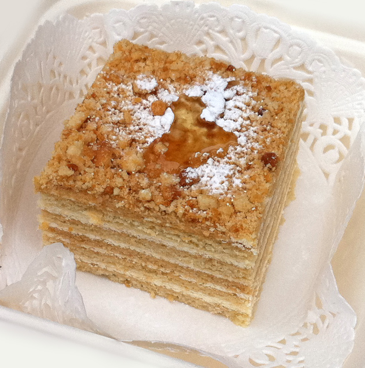
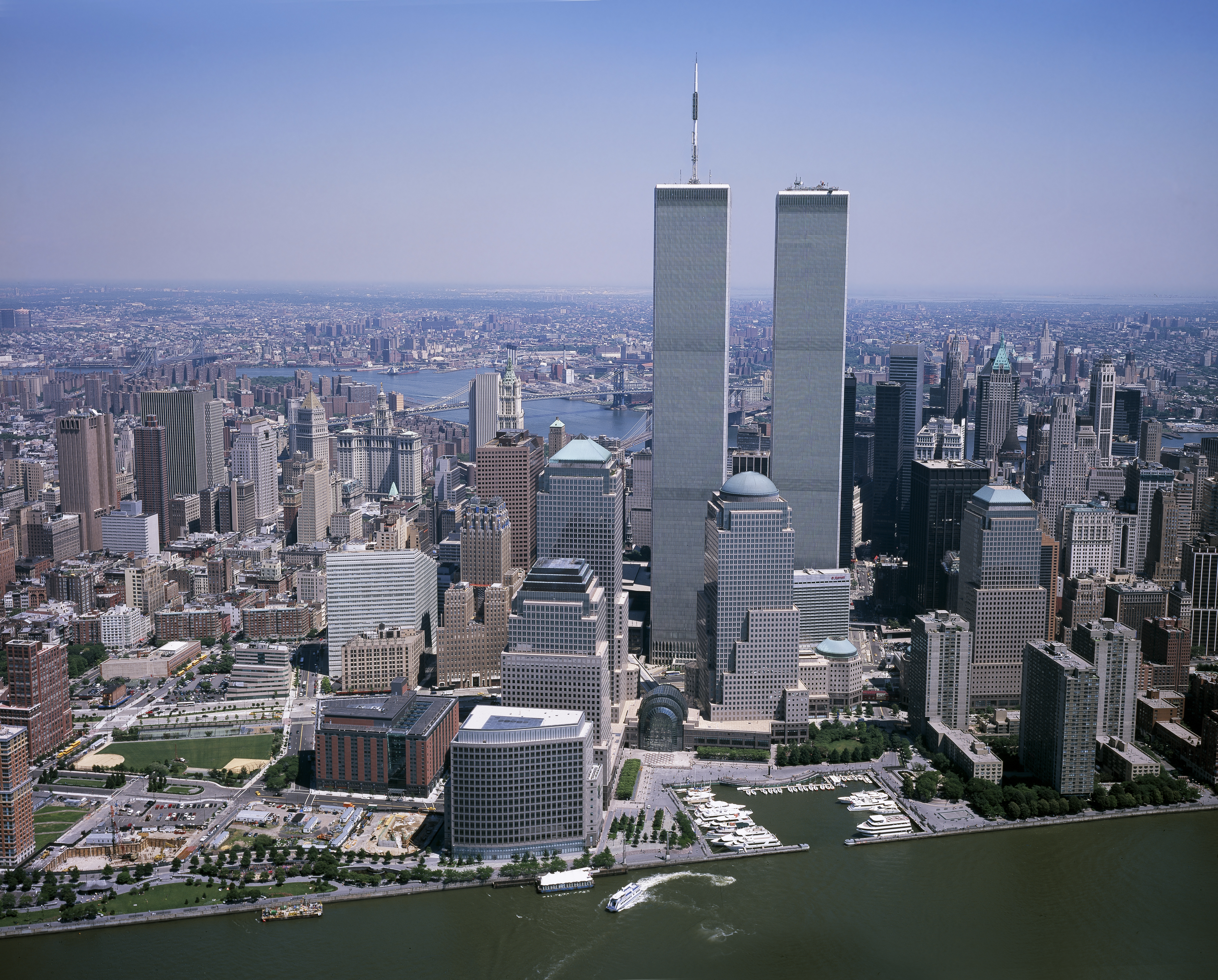
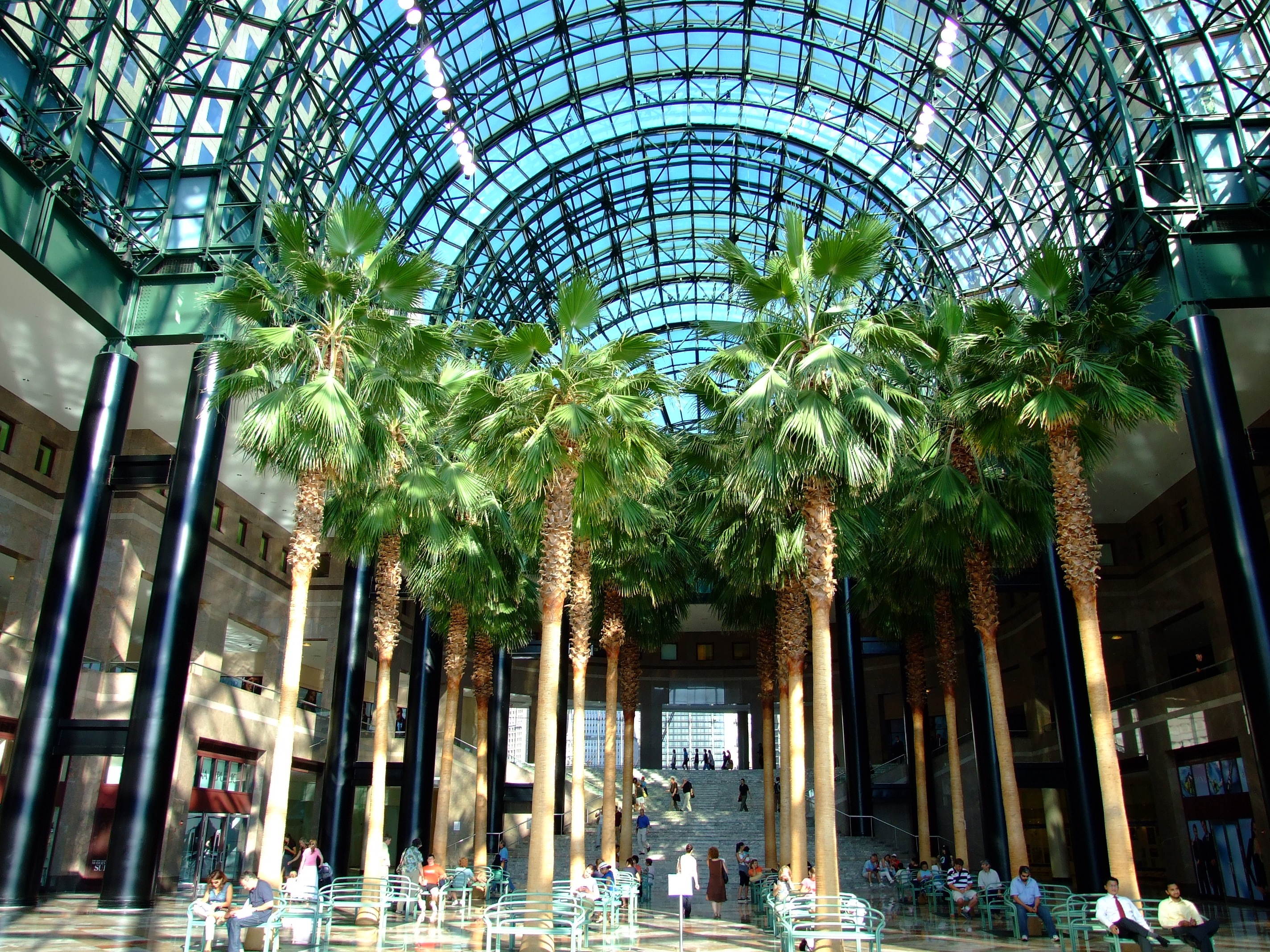
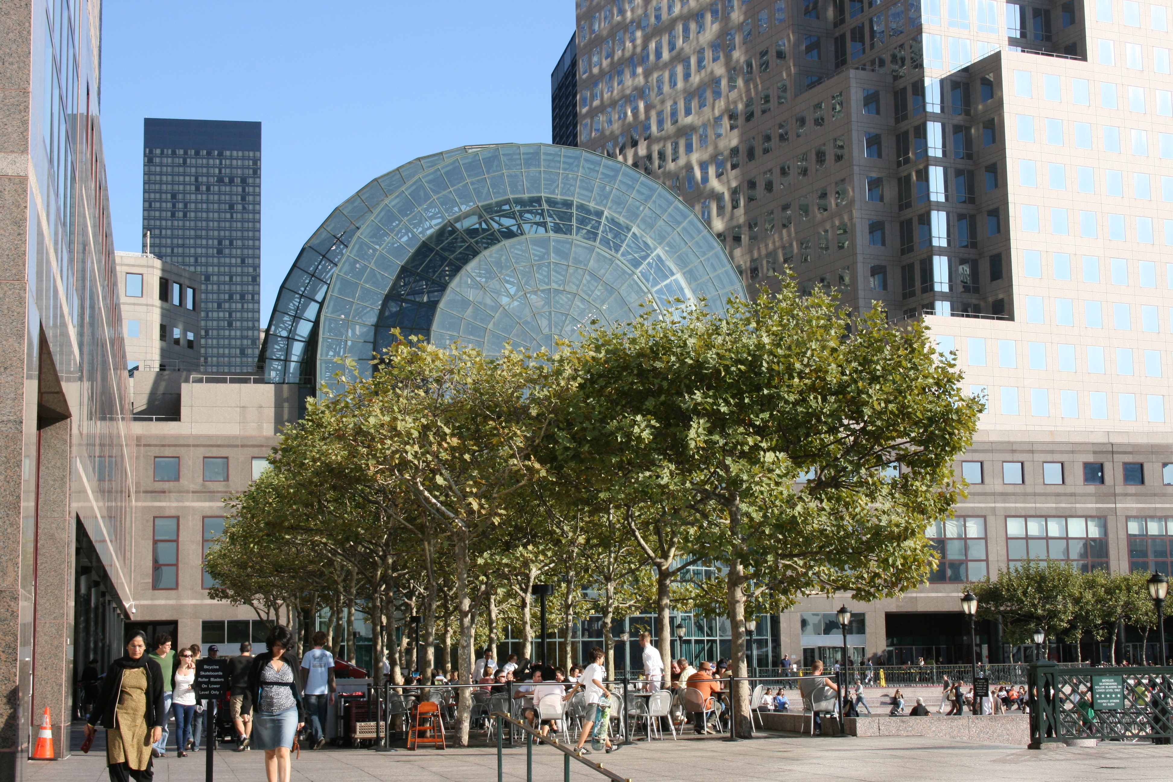
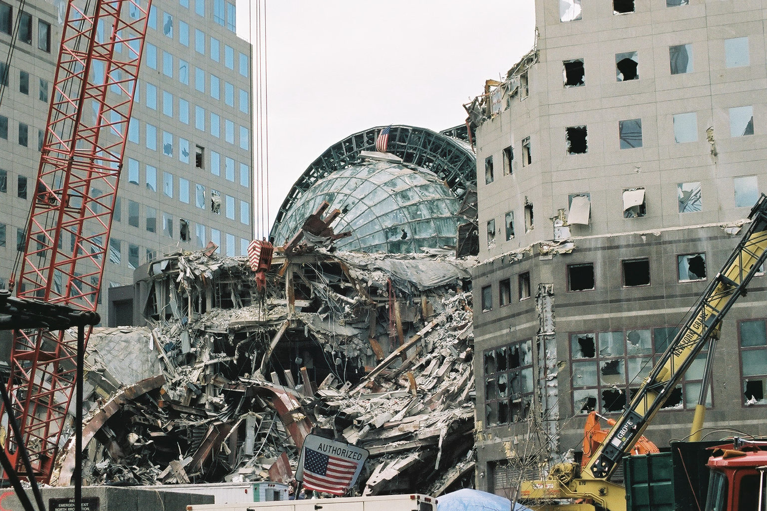
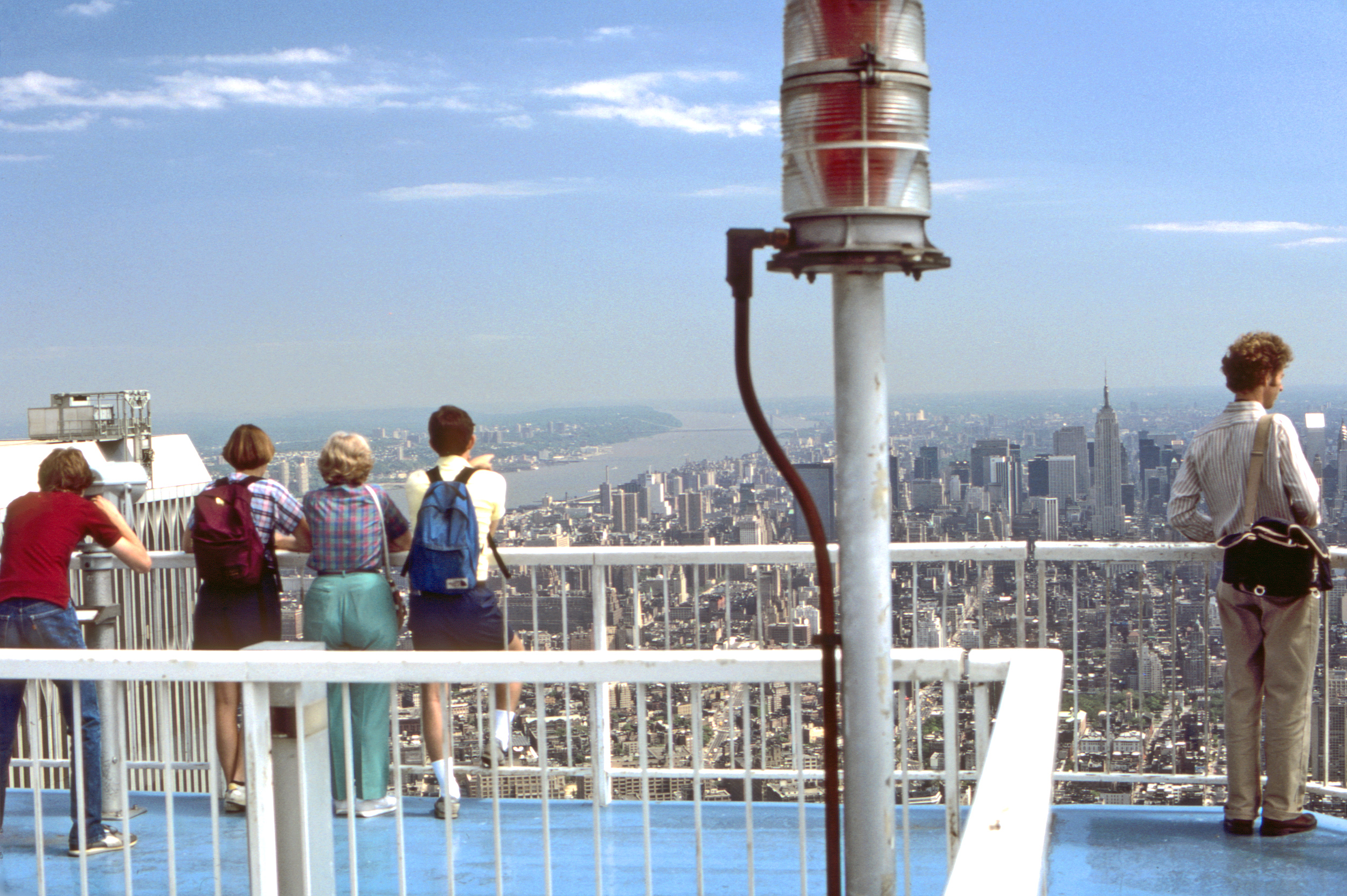
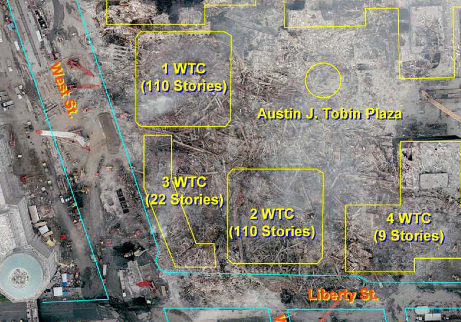
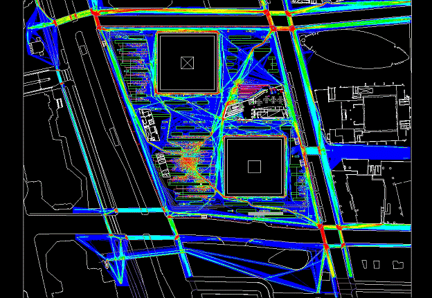
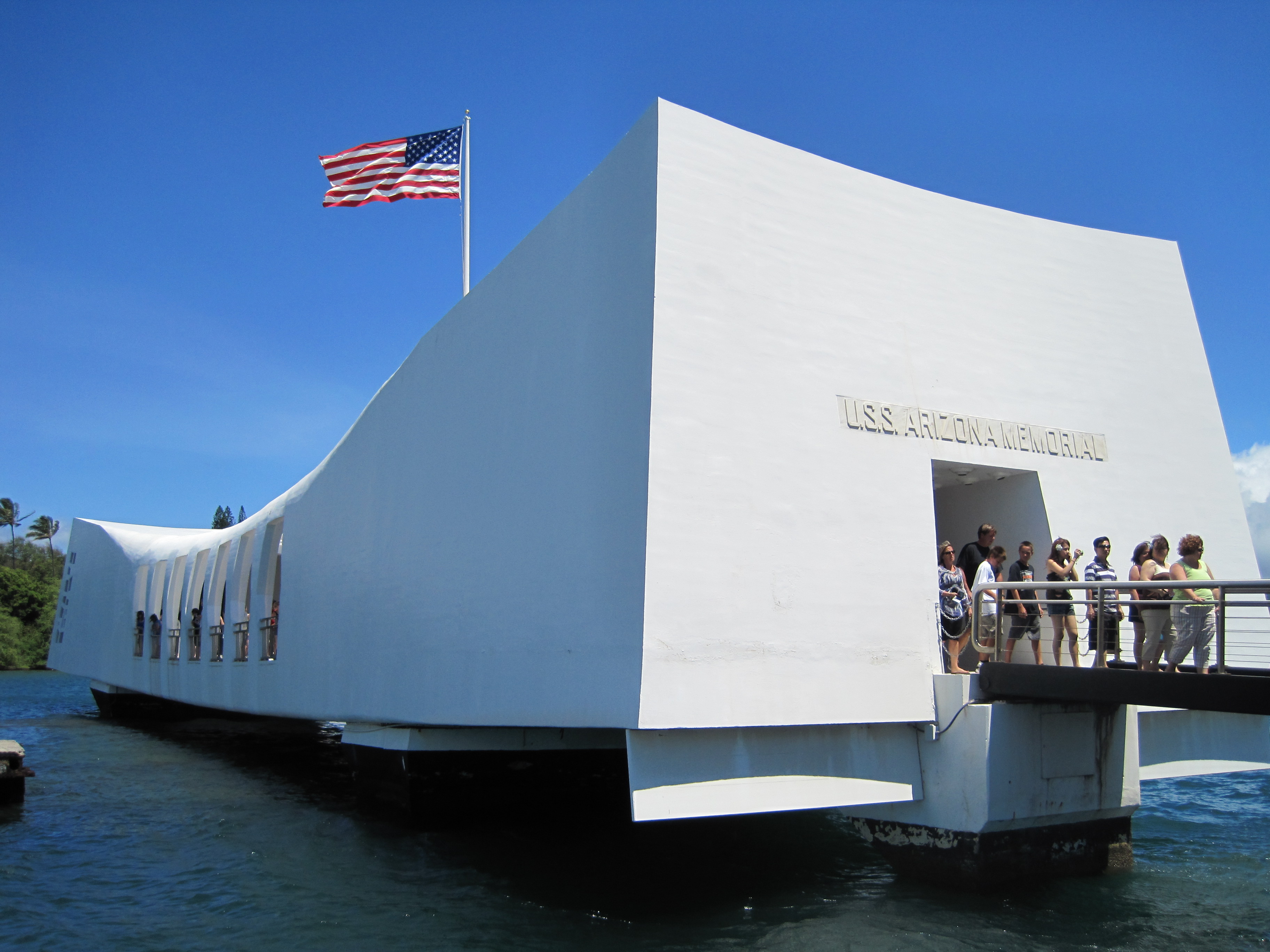
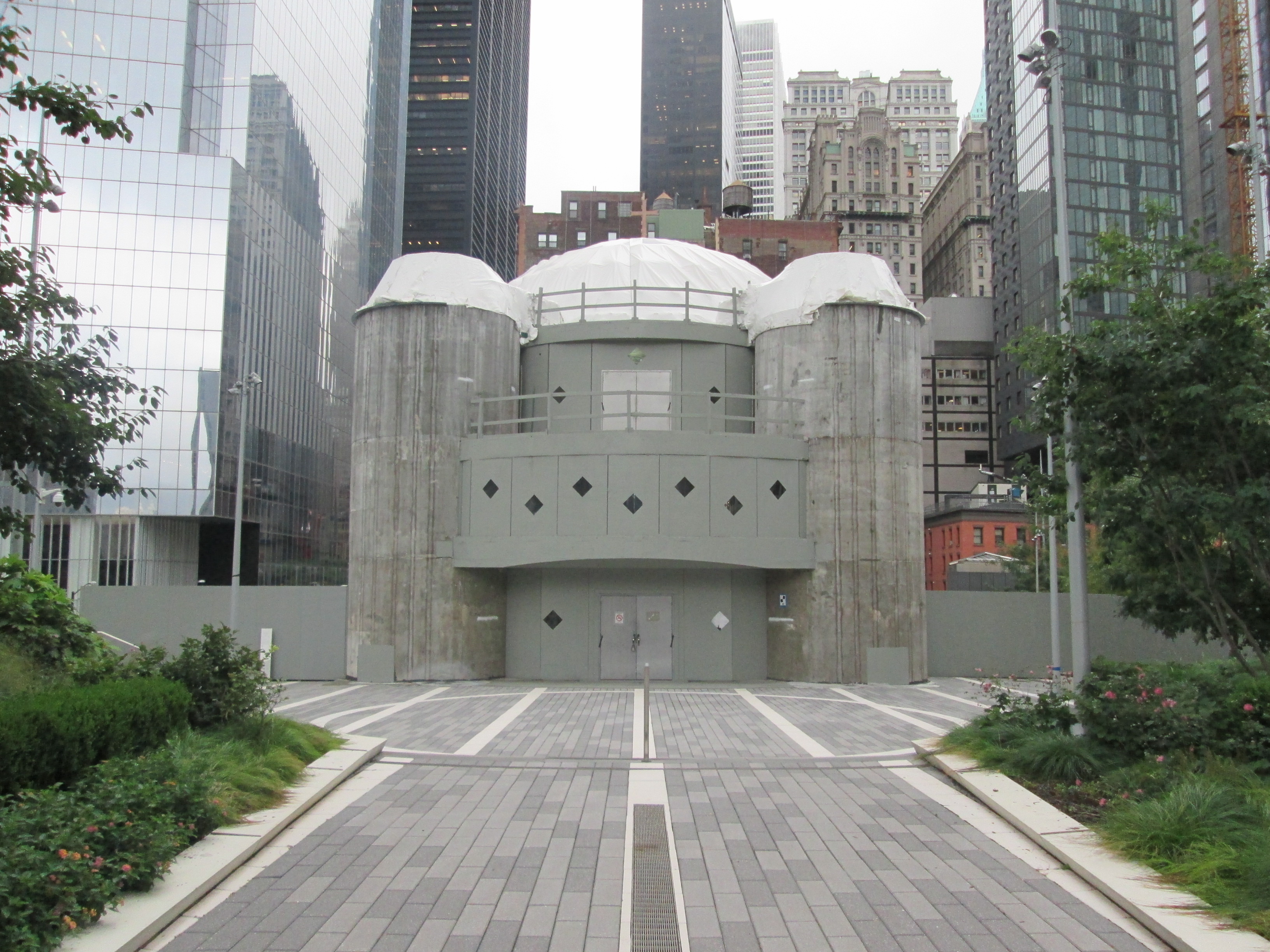
, taken in June 2016 looking west: a very unfinished building with a chain-link fencing closing off passage down Liberty Street and a view toward the elevated Liberty Park in the distance. But today, Liberty Street is open, and, as the previous picture shows, more has been done on the building. But it)