|
Reflections 2020
Series 10
November 12
World Trade Center II - Pandemic Travel II: Birthday in the Ironbound
| | 4) Calatrava's Oculus & the Rail Hubs (cont'd) We barely started out on our pandemic mini-trip, but talked a lot about the WTC Before and After Nine Eleven. Of the four contemporary projects I find of particular interest, we were in the midst of the last one, having described the two rail hubs that are part of the Underground City as well as the head house on the Fulton Center, which, as it turns out, has a genuine oculus. That leaves us to discuss, before we take our one-night mini-trip, just the spectacular head house Santiago Calatrava has built in the WTC, which he also calls the Oculus. I prefer to call that building Calatrava's Oculus. | | | | Santiago Calatrava Born in Valencia, Santiago Calatrava is a Spanish architect and structural engineer. He has designed major buildings, bridges, and other structures of note around the world. Before first visiting the Oculus, I've personally visited two of his projects, so those are the ones I'll reference. Coincidentally, I saw them both on the same trip, exactly two weeks apart. In 2007, I was in Portugal, then Spain, to take the Transcantábrico train across northern Spain. I saw one work by Calatrava in Lisbon, and one in Bilbao.
In Lisbon, I saw Calatrava's Estação do Oriente or East Station, also translated as the Oriente Station (a mistranslation of that word, just as is done with the Orient-Express).
http://www.urbanrail.net/eu/pt/lisboa/lisboa-map.png
The East Station/Oriente Station is easiest to locate using this rail map, which shows the metro lines in color and rail lines in gray. Find the central Santa Apolónia station downtown, which also has a metro stop, then follow the gray line along the Tagus River (rhymes with "pay Gus") to Oriente Station, with its metro line as well. I wrote in 2007/9 (Ctrl-F: Oriente) that the gem left over from Expo 98 was Oriente. It’s just five minutes northeast of Estação de Santa Apolónia, but located instead on main routes. Some trains connect with both stations, but many only with Oriente. Much of the station hugging the rail lines is of modest concrete construction, but its roof is what makes it an architectural masterpiece. When you go up—yes, up—to the platforms, you see the glass roof above you, and no walls in any direction. The roof is 25 meters/yards high, and on tree-like supports. The upper part of each support blossoms out connecting with the other "trees", and supporting the undulating glass roof. You seem to be standing in a sunny glass-and-steel forest. It is of significance that Oriente was built by the Spanish architect Santiago Calatrava . . . who will be building the new transit center at Ground Zero in New York where PATH lines and subway lines will merge. I understand his design there is to be two bird-like wings. If Oriente is a preview, it should be very interesting. And so we now come full circle.
Calatrava designed the station in 1995 of reinforced concrete and it was inaugurated in 1998. The modernist station is not only a high-speed commuter and regional train hub, but it includes a Metro station, a local, national and international bus station, a shopping center and a police station. Also, the decision to elevate the rail line by 19 m (62 ft) eliminated a physical barrier between the city and the adjacent Tagus River.
Back in those days, I didn't know how to insert pictures (or maps) into a posting, but now I do, so compare the above description to this view (Photo by Jonas.tesch). Rather than calling it a roof as I did, I now look on the lattice structure of glass and metal as more of a canopy, which seems to form a "roof of trees". This angular view above street level gives an additional perspective (Photo by Nuno Morão).
https://www.gifex.com/images/0X0/2011-01-28-12869/Tourist-map-of-Bilbao.gif
Just two weeks later in Bilbao, in Spain's Basque Country, when we had a tour off the train of Frank Gehry's Guggenheim Museum Bilbao (click on top of above map), there was free time afterwards, and just steps away upstream on the estuary was a footbridge by Calatrava. You'll see it on the map looking as tho the wind had blown it inside out, but that's Calatrava for you. I like the word for "footbridge"--e saw it in Paris in 2018/7 when on the Canal Saint Martin, which every once in a while had a passerelle crossing it. Pretty word. The Spanish version is just as nice, pasarela, and this footbridge is the Pasarela Zubizuri, which includes a Basque word meaning "White Bridge". It dates from 1997, roughly the same time period as the rail station. In 2007/10 (Ctrl F: Zubizuri), I said: I’ll describe it in three parts. First picture a slightly curved pedestrian roadway ahead of you over the river, something like clock hands at 11:35, but gracefully curved into a concave shape to the left. Then picture a huge, rounded, steel arch over the bridge, but this arch is attached to the roadway’s two ends on the RIGHT side, while the arch tilts over the concave open area on the LEFT side. Finally, almost all the cables connecting arch to roadway also descend from upper left toward the lower right. It’s absolutely amazing, extremely graceful and you just can’t stop staring at it. Another phrasing to describe it is that it consists of (1) a curved walkway of glass bricks, (2) supported by steel suspension cables at unusual angles, hanging (3) from an overhead starkly leaning arch, all painted white.
https://i.pinimg.com/originals/c2/74/1f/c2741f926a1e7b7d9f5691d04764a710.jpg
https://i.pinimg.com/originals/78/59/ed/7859ed197688480e4abc9530cc38bfdd.jpg
Again, compare the above descriptions to these pictures. The top picture shows the bridge as I first came across it, looking north across the estuary. The experience is a bit dizzying, but the footbridge is fun to cross. The bottom picture, the southbound view I got on my return, is more dramatic and striking. In any case, from these two works, it's obvious that Calatrava is a force to be reckoned with. Still, we shall have to see how he will have toned down his modern style for the more traditional rebuilding of Saint Nick's.
| | | | Calatrava's Oculus The spectacular head house Calatrava built at the WTC he has named the Oculus. I think it's a fantastic building and a credit to the neighborhood. I give it high grades, but disagree with his naming decision, mostly because it's hard to agree that the multiple skylights in the building are an oculus, but also because the nearby head house at the Fulton Center does have a genuine oculus that fully illuminates that building. But we'll get to that. For now we'll use "Calatrava's Oculus" to refer to the building, the head house itself, and will continue to wonder if there is a genuine oculus within. | | | | Our One-Night Trip But let's not forget that we're talking about the WTC because we're passing thru it for our single-night trip to the Ironbound. For this we refer again to the After map from the previous posting (Map by Mangoman88). The M20 bus we took (where fares were finally reestablished again just the day before) brought us north on West Street to a point near the Verizon Building. Since my usual path in this area is at the south end, cutting westbound along Liberty, this time we're going to the north end to cut eastbound on the newly reconstituted—and pedestrianized--section of Fulton Street.
http://mcgrawimages.buildingmedia.com/CE/CE_images/2014/Nov_Steel-Institute-of-New-York-11.jpg
But as a supplement to the After map, we can use this detailed one of the area. While we're walking east on Fulton past One WTC, note in yellow how directly under us is located the new West Concourse connecting the transportation hub to Brookfield Place (WFC). It continues behind us under West Street to connect near the Winter Garden Grand Staircase. While the former North Bridge was more logical, connecting two structures at one level above the street, so that people could walk down the staircase, now one goes up the escalators to arrive at the staircase to go down again. But it works. This is the view eastward from the upper level of the Winter Garden, behind us (Photo by Paul Sableman). We're looking at the escalators leading down under West Street to Fulton Street, with a view across the Memorial Park and a startling preview of Calatrava's Oculus on the other side.
So, back on Fulton, we pass right along One WTC with the Memorial Park on our right. We then pass the Performing Arts Center, still under construction. Upon reaching reconstituted Greenwich Street, we're at the intersection that had disappeared decades ago, but which now slices that former campus into four unequal parts. Looking south on Greenwich, we see the other WTC buildings, some still under construction, with the new Saint Nicholas National Shrine (not shown) also under construction on the southwest corner of Greenwich and Liberty. But standing at this intersection, we see our goal the fourth project that I find very highly noteworthy, Calatrava's Oculus above the rail hub that will take us on our short trip.
| | | | | | As we cross Greenwich to our destination, remember the local geography: underneath Greenwich is the brand-new, rebuilt 1 line of the subway and its station with that Oval Entry (my term), and below that is the entry to the PATH station, which is now down BEHIND us on the west side of Greenwich—we were just standing above it before we crossed. The head house itself does not contain the PATH station. |
| | | | The building is shown on this map simply as the Transportation Hub—which it is—and is not otherwise named. Do note its oval shape with two pointed ends. And particularly note that that odd oval is turned at an odd angle within its city block and not parallel or perpendicular to the surrounding streets. But one of its pointed ends does point toward One WTC. We'll soon see why. | | | | Exterior We're at the Greenwich Street entrance, but before we go in, let's first look at some distant views of the building. It's the sort of structure you won't forget, or wonder if you'd seen it, when visiting NYC. When you see something by Calatrava, it stays in the memory. This is a view eastward from the Park across Greenwich Street (Photo by massmatt). Whoa! It's quite unusual, but very graceful and bright white. The tiny entrance from this side to this building is small enough to be hidden by one of the trees in this view, but it's right below that central ridge of skylights sweeping downward. That central ridge is part of an elongated dome with slender white spines extending outward. Look at those rows of spines, resembling a pair of wings. The left ones start out short, then gracefully lengthen, while the right ones start out quite long, and get shorter toward the other side.
Calatrava described this exterior as representing "a bird being released from a child's hand". I love the released bird imagery. As for the last four words, I think that moves the imagery into the cloyingly saccharine. Thus I interpret the imagery simply as that of a bird being released, flapping its wings and bringing a sense of hope, excitement, and freedom.
And again, the whiteness is striking. Few buildings are white. I've never been to the Taj Mahal, but that's notably made of white marble; we have talked about the Sacré-Coeur in Paris (2018/8), which is starkly white; and near here, we've just discussed Saint George's Syrian Catholic Church, whose striking façade is white terra-cotta. Whiteness does wonders to a building's presentation, and an illuminated night view of that whiteness is perhaps even more spectacular (Photo by Billie Grace Ward).
Here we have the opposite, the view westward across Church Street (Photo by Shaun Dawson). This picture was taken in 2016, and still shows some of that bothersome chain-link construction fencing on the left I've spoken about, but which is mostly gone now. Again you can see how the wings vary in length front-to-back on each side. I think Church is still the busier street than the rebuilt Greenwich, and perhaps this entrance (click), tho still small, is a bit busier. Actually, both street entrances are surprisingly small for a building that's so massive inside. You'll recall that Church Street is the location of the Cortlandt Street Station—click on the lower right to see a street entrance to the subway—which is linked to three others under Church Street further north. If you click on the lower left, you can see the black arches of the Winter Garden across the Memorial Park. And of course, you can't miss the isosceles triangles of One WTC, toward which the skylights are oriented.
But back to our visit. We cross Greenwich and see the petite western entrance (Photo by Tdorante10). To the left is Fulton Street, still showing some rather ugly construction equipment in this view—it's gone now. But this is my third time in the building, and I haven't had a chance to look at the exterior up close, so let's step around to the Fulton (north) façade and see what that's like (Photo by Owen Allen). Several things surprise me. Look how gracefully the ribs climb the wall, then fan outward to form the spines. Then note that between the ribs there are translucent panes that let a diffused light in. They seem only translucent here, but are transparent above street level. And the most pleasant surprise for me was the benches! Between every rib all around the building are benches for the weary. We weren't particularly weary, but had to try one out anyway. It's fun sitting on the dome of a building, but with your feet still on the ground!
The exterior of this building is amazing, which is why I think Calatrava made a mistake with the name "Oculus". The building represents—very abstractly, of course—a sculpture of a bird, taking off to freedom. Why not call it "The Bird", "Bird in Flight", "The Dove", even "The Phoenix", representing the new WTC arising from the old? I think that the naming was a missed opportunity. The favorite suggestion I've come up with so far for a better name for this building would be "Rising Bird".
| | | | Interior Before we enter this remarkable building it has to be explained why, even tho it's quite large outside, it's SO huge inside. I wish somebody'd explained this to me before I went there the first time, but if you know the secrets of this building, it helps to enjoy it. A head house is always above the train area, and usually completely so. But all you see when you're outside is the domed ROOF of the building, which is another reason I enjoyed sitting on that "roof-bench". The entire "Rising Bird", big as it is, is totally hollow, just like an attic, and those beautiful ribs inside—tho much more attractive--are like the beams in an attic.
https://images-na.ssl-images-amazon.com/images/I/31chRlII9EL.jpg
The best metaphor to explain how this building is set into the ground is that of an oval roasting pan with a domed lid (above). The bottom part of the pan is the "business" part that holds the turkey, while the domed lid just covers it. The Rising Bird is the empty domed lid, while the pan is the part of the building set well into the ground. Now let's go in.
This first view of the interior westward toward Greenwich Street is a bit restricted, since it emphasizes only the empty space below the roof (Photo by soomness). Look at the row of skylights, and notice those interior ribs. The "roof" ends where you see the color change, and this is at street level. Click to inspect the Greenwich Street entrance, which mirrors the Chambers Street entrance opposite it where this view was taken from.
People entering thru the doors are still at street level, meaning everything beyond is below street level. The view of the interior is good from the entrance area, and better down the steps to the projecting viewing area. Leading down from here are escalators and more stairs to the oval balcony that surrounds the entire interior, and also to the Oval Entry to the 1 line of the subway.
The rounded shape near the entrance doors is an elevator that also goes down a level to the oval balcony—you see the next rounded shape below the projecting viewing area where it arrives—but not to the Concourse, one level further below. At the (dark) end of the Concourse you can barely see the rounded staircase down to the PATH trains, where we're headed.
So now let's get a fuller view in the same direction, one that includes the entire interior (Photo by Arild Vågen). Disregard the construction in the center of the Concourse in this much brighter picture on a bright day where the skylights are causing a "spotlight" effect on the side of the Concourse, which we'll discuss shortly. Just below street level you can see the shops on the oval balcony that totally surrounds the Concourse, as well as the Concourse shops. You can also note the numerous floodlights around the sides, two between each rib, assuring that this interior can always be brightly illuminated. Finally, click on the far side again, where it's much easier to see that people are going down steps to the PATH station towards the left, and into the West Concourse to the right, under Fulton Street back to the Winter Garden and Hudson River ferry dock.
All the shops we're looking at are part of the shopping mall called the Westfield WTC, which opened in 2016 as the largest shopping complex in Manhattan, with 125 retail spaces. It's the equivalent of the former Mall at the WTC that we saw in the last posting. But while the former mall was single level, this one has multiple levels. We see two levels in this building, but remember, everything is attached here. The lower floors of 2 WTC and 3 WTC have three additional retail floors above street level, and 4 WTC has four. And do remember that the other hub, the Fulton Building, is filled with related retail space. Thus this shopping mall doesn't look like the single entity that it is, but stretches its tentacles all around, like an octopus.
This view, again westward, is taken from the balcony level and emphasizes the Concourse and its expansive width (Map by Rhododendrites). Notice again not only the spotlight affect of the skylights on the floor, but also the fact that artificial illumination is an ongoing effort, visible near the top in the orange lighting at street level.
| | | | The Size! But it's the size of the indoor space that overwhelms. Historically, vast cathedrals and traditional grand railroad stations have been known to exhibit large interiors. As a teenager on my wanderings around Manhattan, I remember to this day first walking in to the front entrance to the Cathedral of Saint John the Divine uptown and seeing the jaw-dropping size of the nave. It's the world's sixth-largest church by area, with a nave 76 m (248 ft) long and 54 m (177 ft) high. I'm sure I've since seen other cathedrals as large and larger.
As for expansive railroad stations, the Grand Concourse of New York's Grand Central Terminal is 83.8m (275 ft) long and 38.1 m (125 ft) high.
But Calatrava's Oculus is 106m (348 ft) long and 49m (161 ft) high. It's a vast space. And it should also be taken into consideration that Grand Central is a head house built for mainline trains, whose tracks end for the most part on its north side, while Calatrava's Oculus was built as a head house as defined two ways. It's a railroad head house of sorts, since PATH trains end in a loop on its western side, but it's more spectacularly a head house for all the subway lines that converge here. And it is highly unusual, possibly unique, for a subway/metro station head house to be built on such a grand scale. It's surely the largest and most spectacular subway/metro head house in the world.
One last interior picture before moving on. This is an evening view down the length of the Concourse (Photo by Anthony Quintano). Even tho there is supplemental illumination to external light during the day, after dark, all those floodlights really show how bright and white this building is. The is the only view so far eastward to the Church Street entrance—click to see the names of the subways in the distance. You can also see better the unusual semicircular elevator connecting the entry with the balcony one floor below.
| | | | Architectural Extras Little extras sometimes creep into architecture, and can involve sound or light, and can be accidental or purposeful.
An example of an accidental sound phenomenon is the several whispering galleries around the world. The two I've visited are the following. Since certain spaces with curving walls and domes can produce a unique sound experience, in this case, a speaker faces the wall in one corner and whispers something while a partner stands at the opposite corner. The rounded architectural shapes cause the whisper to transmit as clearly as if the two were standing next to each other. This can famously be experienced in Statuary Hall of the US Capitol building.
The other location involves, once again, Grand Central Terminal. In 2018/12 (Ctrl-F: Oyster Bar) I discussed a visit with friends to the Grand Central Oyster Bar. I included this picture of the arched main entrance to the restaurant from the vestibule outside (Photo by Leonard J. DeFrancisci), which, like the restaurant, is covered with the famous Gustavino terra-cotta tiles on its arched ceiling. The domed arches and slick tilework are highly conducive to the movement of sound, and create a whispering gallery. If that man on the right were to face the wall and say something, a person in the diagonal corner would hear it perfectly, since the sound waves would shoot up the one corner, along the smooth, arched surface of the ceiling, and back down the pillar on the opposite side.
Light phenomena seem to be more purposeful. Most obvious involves one of the principal theories about why Stonehenge exists, that the site and its stones mark, for religious purposes, the alignment of the sunrise of the summer solstice and also the sunset of the winter solstice. Following is the 2005 summer solstice sunrise (21 June) between the standing stones (Photo by Andrew Dunn). Beverly and I have visited Stonehenge, tho it was not during a solstice, and certainly not at dawn.
| | | | | | As a footnote to that, we can again mention Manhattanhenge, the phenomenon where the setting sun lines up with the east-west numbered streets of Manhattan, eagerly photographed each year. See 2018/4 Ctrl-F: Manhattanhenge for pictures and more information. |
| | | | An Oculus Within a Dome So how do these architectural phenomena affect Calatrava's Oculus? I continue to state I really like the building, but I think he got carried away about its purpose. He considers that it contains an oculus, and has—so very oddly--named the entire building The Oculus to indicate so. I doubt that what the building contains is an oculus, and even if it is, the bird-like form of the building's exterior to my mind takes precedence as to what it is, and the building should have been named accordingly. Let's start at the beginning.
The Latin word for "eye" is "oculus" (plural "oculi"), and appears in such English words as oculist and ocular. But the word is used in its original form as an architectural term in English and other languages (with slight variations) to describe an opening, always circular or nearly so (hence the eye connection) used to let in air and light—and a few drops of rain, perhaps, if not glassed over. As shown by these Manhattan examples, an oculus can appear in a wall, as here in Carnegie Hall (Photo by Tony Hisgett), but is most often associated being up above, as part of a dome, often including a cupola, as here in Federal Hall on Wall Street (Photo by Gryffindor).
But to my way of thinking, the word "oculus" has to bring to mind the 2C Pantheon in Rome, one of the most famous oculi, which strikes me as really being the centerpiece of the structure. The oculus in the Pantheon (Photo by Miguel Hermoso Cuesta), is beautifully minimalist, just a circle in the ceiling for light and air, with no cupola and no covering against the weather. Because of this simplicity, it's known, on sunny days, for its spotlight effect (Photo by User: Bgabel at wikivoyage shared), where the moving sun during the day keeps on highlighting an ever-moving spot, and one that changes with the seasons. This famous light event was beautifully captured in the 18C in this c1734 painting by Panini.
| | | | The Parlor Trick Tho it's not eye-shaped, Calatrava considers his row of skylights looking to the sky to be his "oculus". I don't see how a 102 m (335 ft) vagina-like strip of skylights can be considered an oculus. But let's give him the benefit of the doubt. To play the devil's advocate, I've made up a new term. Let's call it, quite uniquely, a "linear oculus". Adding expense to the construction, the numerous windows in the skylights have been made to open mechanically (also manually) for light and ventilation. Fair enough. But all those motors and movable rubber-sealed windows require (acrobatic) maintenance (Photo by Kxie16). Click to see details. Better yet, let's go up top to see just what the workers need to do (Photo by Billie Grace Ward). To top it off, what I've read is that the skylights only open on Nine Eleven. I hope that isn't true. All that effort and machinery should at least be taken advantage of more frequently than that, but I don't think so.
But why have a "linear oculus" at all? It was to commemorate Nine Eleven in a way. We saw on the After map that the entire building was built slightly off-kilter as to the city block it's on and as to the adjacent streets. The reason for that is so, if you go to the east side of the Concourse, and look up and back to the west thru the skylights, One WTC lines up perfectly within the opening.
https://tribecacitizen.com/wp-content/uploads/2017/09/WTC-Oculus-roof-open-on-911-by-A.jpg
As even the name of the above link itself shows, this is the open skylight on September 11, 2017. Click to enjoy the view, but I have no indication if it opens at other times. But then comes the parlor trick because of this angle. You've seen in above pictures how the spotlight effect of the skylights--on a sunny day-- illuminates a strip on the Concourse floor. Supposedly in the morning on the anniversaries of Nine Eleven, because of the angle of this building, the strip of light is centered on the floor of the Concourse, which is supposed to be some sort of homage to the victims.
https://thebeautyoftransport.files.wordpress.com/2018/06/42137633481_b3233a1ff9_z.jpg?w=768
But I don't see how. First, this link seems to show that centering of the strip, but the windows aren't open, so it might be close to the anniversary, but not precisely on it. Nevertheless, how is a view of One WTC, which didn't exist at the time of the Twin Towers, supposed to be anything more than an architectural quirk, like the whispering galleries are? How is a strip of light on the floor an homage? Why are the skylights considered an oculus? Why is the whole building referred to as The Oculus, when it's such a minor feature? It's particularly nonsensical when you think that the Fulton Building on Broadway, just one block east of the Church Street side, has a REAL oculus, that serves a genuine purpose of brightening up the interior (that net of mirrors helps) down to some underground platforms?
And I do not believe the millions of people passing thru the transit hub realize that this parlor trick exists at all in this building. Let's assume the man in the street even knows what an oculus is. All he sees in this building are skylights showing a sliver of sky and other buildings. And as for the commemorations on Nine Eleven, all newspapers and TV news shows cover the reading of the names of the victims. Everyone is aware of the Tribute in Light that evening. But I've never heard of anyone ever mentioning being aware of the parlor trick that this building does on that day. In contrast, masses come out to photograph Manhattanhenge during the solstices, and it's in the papers and on TV.
The price tag of the project was incredible—it took almost four billion dollars to put up this building, and that's billion with a B—way double the original budget of $2 billion. True, some were changes the Port Authority wanted, and others were changes Calatrava wanted. But many changes were to reduce expensive items. I can only try to imagine what it cost to put those windows in. They would have been a lot cheaper if they were fixed and not movable.
Take a look at this short (1:20) YouTube video of the open skylights on the anniversary of Nine Eleven in 2017 (same as the still photo above), showing the view thru it and the line of light on the floor. Some commuters are paying attention, but not as many as you'd think.
I'll repeat that I like and enjoy the building as a contribution to both my neighborhood and to NYC, but this parlor trick was not necessary. It was well-intentioned, but it should have been simplified, with cheaper fixed windows. The word "oculus" is out of place, since—let's face it--there is no oculus here. This tribute few people pay attention to should be called something like "Skyview Tribute" and the building should be called "Rising Bird" or something of that sort.
| | | | Similar Structures I have a challenge. What other structure or structures are similar in style to Calatrava's Oculus? When talking about One WTC, we made comparisons to the Chrysler Building and even the Empire State Building. What else would fall into the architectural category of "Rising Bird"?
I'm sure you won't agree at first, but hear me out. I think I can convince you. It's the so-called "Statue" of Liberty. Now I have nothing against it. I admire it as much as anyone, and see it to the left of my windows all the time. But here is my contention, and I do feel I'm right:
| | | | | | The "Statue" of Liberty is not a statue.
It's a building, whose upper portion is made to resemble a female figure.
|
| | | | While the name is with us to stay, I have two comments about it. As I've mentioned in the past, its full name is longer: La statue de la Liberté éclairant le monde / The Statue of Liberty Illuminating the World. First, it's unfortunate that we shorten it, which makes it into a passive figure, not doing anything, just standing there. It if had become famous by its full name, or even something like "Statue of Liberty Spreading the Word", she becomes active and is actually accomplishing something. But that point is trivial.
More unusual is that it's the only structure I can think of whose name includes the word "statue", as tho the public needs to be convinced. We speak of the Venus de Milo, or of the David by Michelangelo, or of the Pietà. Cite them or any other statue—the Charging Bull near Wall Street—and "statue" is not part of the name. Why here? It would seem to go back to Bartholdi, who formulated the name for his "statue". Let's define what a statue is and what a building is.
| | | | Statues It's best we put stone statues aside—most often marble, as with Venus/David/Pietà-- since that would be comparing apples to oranges. Since our "statue" is metal, let's compare it to Rodin's Le Penseur / The Thinker (Photo by Douglas O'Brien), or even to the Charging Bull (below).
https://suiter.com/wp-content/uploads/2017/04/bigstock-Charging-Bull-in-Lower-Manhatt-87193583-1.jpg
Both statues are supersized. The Thinker, seated on a stone pedestal, is 1.85 m (6 ft 1 in) high, so as a standing figure, he'd be a really big boy. The bull, with no pedestal, IS standing, and is 3.4 m (11 ft) tall and 4.9 m (16 ft) long. While small statuettes can be even of gold or silver, the usual metal used is bronze (composed of copper, tin, more), as these are. Oddly, the "Statue" of Liberty is made of copper alone, which accounts for it being so much more oxidized to a bright green color, more so than the Thinker. (I don't know why the Bull hasn't changed—maybe it was treated, or maybe it isn't old enough. But do note the green front hoof.)
Metal statues are cast, almost always in one piece. Occasionally the odd stretched-out arm or horse's raised leg has to be cast separately and welded on, but that's a minor cosmetic matter—metal statues are essentially one-piece, and, in larger sizes, always hollow. They may be of heroic size, as above, but—it sounds dumb saying this—people can't enter into them.
| | | | Buildings Smaller buildings are built from the outside in. They have load-bearing outer walls, be they wooden (frame), brick, or stone. Once the outer walls are built, the interior is fitted out with beams for floors, or, in a case like a fortress, additional load-bearing walls can be added to the interior.
Larger buildings are built from the inside out. First a steel skeleton is built, as we saw in the "bathtub" pictures showing the skeletal base of one of the Twin Towers. This is a view of the new One WTC under construction in 2010 showing just the internal steel structure (Photo by Ungunstung). Consider it "all skeleton, no skin". Here it is in 2011 with surface panels--"skin"--being installed from the bottom up (Photo by Sam Szapucki), and then in 2012 as the panels approached the top (Photo by Mariordo).
| | | | "Statue" of Liberty We can show that, tho we'll continue to call it a statue as we've become accustomed to do, this structure is in actuality a very clever illusion and is actually a building. The lower part of the building is made to look like a pedestal for a statue and the upper part is made to look like a female figure, completing the illusion of a statue raised on a pedestal. Let's follow its construction up to its opening in 1886.
The lower part of the building—the fortress-like "pedestal" (as shown here in Harper's Weekly in 1886, with a view toward the Brooklyn Bridge, opened three years earlier, in 1883), is of granite and stone, with supporting outside walls. There may be some steel supports and cross-beams inside, but it doesn't have a steel structure. Tho it's shaped to imitate a pedestal, it's clearly a building, with a lobby, two floors of exhibits, and elevator shafts going up 27 m (89 ft) to its top. When it was almost completed, it looked more like this.
The other name, along with Bartholdi's, that's associated with this structure is that of Gustave Eiffel, who opened the Eiffel Tower just a few years later. It was Eiffel's engineering skills that were needed to design the steel skeleton for the upper part of the building, which was to look like a statue.
http://cdn.newsapi.com.au/image/v1/094236b29c15453786a023b264749dfd
https://alancook.files.wordpress.com/2010/03/241.jpg
You can see in the first link the steel structure Eiffel built for the upper part of the building above the stone base. The body of the figure and the torch arm would surround these girders. Beyond that was a layer of thinner trusses to which the copper "skin" would be attached. I particularly like the drawing in the second link because not only does it show the "skin" around all the supports, it also shows how Eiffel had to compensate for the precariously extended torch arm with counterbalancing girders in the arm holding the tablet.
https://i2.wp.com/clickamericana.com/wp-content/uploads/statue-of-liberty-face.jpg?resize=600%2C585&ssl=1
https://3.bp.blogspot.com/-vbQ0KEz-dp8/WAhUQNDNgDI/AAAAAAAALjw/bS8PWbt4fq001R1RJBhHZk1O9NmtOdkyQCLcB/s1600/unboxing_the_statue_of_liberty_3.jpg
I searched for a long time to find pictures of the pre-shaped pieces of copper plating that were attached to the framework of trusses then riveted and welded together, but the best I could find were the two above views, one inside, one outside, of the face that had to be attached to the viewing room (an "attic room") built at the top of the figure that would serve as the inside of the head. The inside of the face shows some of the additional supports that would be attached to the trusses already in the structure.
This building differs from others in that there's no reason to have intermediate floors above the "pedestal" until reaching the "attic" room in the "head". While the "pedestal" has elevators (and emergency stairs), the "statue" has only a pair of staircases to the attic. This upward view (Photo by Daniel Schwen) shows the interior of the "statue" part of the building showing both the principal steel superstructure as well as the extended trusses reaching out to support the copper "skin" and keep it steadily in place. In the illuminated lower right (click) can be seen some of the riveted seams connecting adjoining copper plates. In the center is the double spiral staircase for visitors to reach the "head" and return down. Another way to describe it is a double helix, a term which should be familiar.
| | | | | | A corkscrew is in the form of a helix; so is a spiral staircase. Two intertwined helixes form a double helix, which is how visitors enter and exit the "statue" part of the building. We hear the term "double helix" often today to describe the shape of the DNA molecule, where one chain coils around another. Let's look at an animation of a rotating DNA double helix (GIF Animation by brian0918). Just disregard the rotation to imagine intertwining staircases in the "statue", one for going up, the other for going down. |
| | | | This next picture shows more of the truss structure and double helix stairs (Photo by Islander), but here you can see visitors ascending one spiral above those descending the other. There are 162 steps one way. The total height of the copper "statue" to the torch is 46 m (151 ft), but to the top of the head and its "attic room" it's only 34 m (111 ft), which is far as visitors are allowed to go, as I experienced on two occasions over the years. Today only maintenance workers ascend to the torch and its outdoor viewing platform.
We saw that the "pedestal" part of the building had an occasional window-like opening. But does the "statue" have windows? You bet. That attic room in the head has a row of 25 windows made to look like jewels in the crown (Photo by Noconatom). The width of the "head" from ear to ear is 3.05 m (10 ft) and its height from chin to cranium is 5.26 m (17 ft 3 in). Thus, that's the size of the viewing room in the "attic".
http://www.howitworksdaily.com/wp-content/uploads/2016/06/Statue-of-Liberty-with-annos.png
I include this sketch, which largely repeats much of what we've said, primarily because it shows the size of the attic room in the "head" (click) that serves as a viewing area at a height of about 22 stories. Note how the person up front has just arrived, and how the lady in pink is starting to leave. About 30 people can stand near the windows in this room, tho it's usually more crowded than this. You can also see the vertical trusswork that keeps the copper exterior of the building—its "skin"—in place.
And the result of artfully shaping the exterior of this building in this manner is this, the illusion of a statue on a pedestal (Photo by User:Mcj1800). Even tho people swarm thru this building and its exterior is made of sheets riveted together, unlike any normal statue, we'll continue to call it a statue. We'll continue to admire it as a statue. But we'll also think about the little boy who told the crowds that, in reality, the emperor has no clothes.
And so I continue to compare Calatrava's Oculus, depicting (abstractly) a Rising Bird, to the Lady in the harbor depicting Liberty. And then there's always Lucy.
| | | | Lucy the Elephant Lucy is a wooden elephant in Margate City, New Jersey, which is on Abescon Island on the Jersey Shore about 8 km (5 mi) to the southwest of Atlantic City. Actually, Margate is so close that it was once called South Atlantic City, but was renamed after Margate, England, north of Dover.
In 1881, right in the decade we've been discussing, James B Lafferty, a land developer, got a patent from the US Patent Office giving him the exclusive right to make, use, or sell animal-shaped buildings for a duration of seventeen years. Thus he had a six-story elephant-shaped building constructed of wood and tin sheeting in Margate City as an example of novelty architecture. Its purpose was to attract tourists in order to promote real estate sales in the area. Here we have a modern front view of a restored Lucy. Click to see how the tin sheeting is welded together, and to check out the windows, including the two that form the eyes. This is a side view of Lucy showing the windows better--click to see the size of the people standing below. And this is an impolite rear view of Lucy that gives a whole new meaning to the term "rear window". Click to see that one leg has the tour entrance door and the other has the exit. There's also an upper-level interior staircase to go up to the howdah for the view. (All Three Photos by Acroterion).
Lucy was modeled after Jumbo, the famous Barnum and Bailey elephant, whose name has become an adjective in English. Lucy stands at 19.7 m (65 ft) in height, 18.3 m (60 ft) in length, and 5.5 m (18 ft) in width and weighs about 90 tons. It is listed as the 12th tallest statue in the US. But is Lucy a statue or a building? There are 22 windows placed throughout the structure. And there's a biological error: only male elephants have tusks, but Lucy has always been referred to as a female.
Two similar elephants were built. One, in Coney Island, was a duplicate of Lucy, but twice the size, and served as a hotel, but that burned to the ground. There was also one in Cape May, the Victorian resort at the southern tip of NJ, which was smaller than Lucy, but is also gone.
Lucy has been a restaurant, tavern, business office, and residence. It's been referred to as a hotel, but the actual hotel at that time was in an adjacent building. However, in 1902, it was rented out as a residence to a family of six. But by the 1960s, Lucy had fallen into disrepair, but was saved by a local committee, moved nearby to a city-owned site, and restored as we see her now. Lucy is a National Historic Landmark, and is the oldest surviving roadside tourist attraction in the US. In 2016, Lucy had 135,000 visitors, 35,000 of which took the guided tour. Beverly and I have visited Lucy, but for some reason never took the tour—perhaps it was closed that day.
This is the original US patent awarded Lafferty, which shows the Main Hall in the central body for visitors, as well as the staircases, including some circular ones. I'm beginning to see more and more parallels to Bartholdi's work. This is the Main Hall looking rearward showing the rear windows with a partial view of tail. Now let's turn around to see the Main Hall looking forward toward a raised landing under Lucy's two blue eyes (Both Photos by Acroterion).
On 27 February 2020, Lucy became the first and only National Historic Landmark allowing overnight stays. Lucy had just turned 138, and so she was listed on Airbnb for $138 per night. It marked the first time Lucy had been inhabited since it was rented as a residence in the early 1900s. Richard Helfant runs the nonprofit that operates and maintains Lucy. The family in 1902 had installed a second floor within the structure to include a parlor, kitchen, and bathroom. Those later additions were all removed in the restoration, and so Lucy has no running water, but a mobile trailer with a bathroom will be at Lucy’s feet. A staff member and a security guard will be on hand in the nearby gift shop.
https://static.seattletimes.com/wp-content/uploads/2020/02/7f29f47e-bd2c-40ea-a993-ef9b504fc6b5-780x520.jpg
This is Richard Helfant showing the bed and Victorian furnishings Airbnb has installed. Breakfast will be delivered, to be eaten at the table on that landing in the back near Lucy's eyes. A gift card will also be given to dine at a local restaurant.
And so: is Lucy a statue or a building? It's clearly a building made to look like a statue, just like the Rising Bird and Lady Liberty.
| | | | | | Finally, a quick look at Mount Rushmore in South Dakota (Photo by Dean Franklin). No one has ever called these four sculptures statues, and there's no building involved here. So why include it? It's something else in disguise, not a building made to look like a statue, but similarly, a mountaintop being made to look like four presidential busts. |
| | | | Birthday in the Ironbound We're back in Calatrava's Oculus on our trip to the Ironbound. Descending from the Greenwich Street entrance, we can take the elevator, escalator or stairs down one level to the balcony.
http://cbsnews1.cbsistatic.com/hub/i/r/2016/09/08/c8fad740-21d3-4470-9ef5-d166a1525502/resize/620x465/1019d8e3f54b28c91821256ab5071621/daniel-jones-concourse-and-stairs.jpg#
But the architecture is a little quirky here and we can't directly down to the PATH station because we're at the Oval Entry to the Cortlandt WTC station of the 1 line (Photo by The All-Nite Images). Note the glass elevator on the right, escalator, and steps we're on. Here are the turnstiles to the Uptown platform with a view across to the Downtown platform (Photo by Aude). But we need to get lower still, and if there's another elevator nearby, I couldn't find it, so we walk past the shops on the balcony level (Photo by Paul Sableman) a quarter of the way around the oval to the central escalators (Photo by Paul Sableman), which get us down to the Concourse. We then have to walk back to a point under the Greenwich Street entrance!
Once there, we walk down a convex stone staircase to our goal, the PATH station (Photo by Pedro Szekely). As you can see, it's as bright and white as all the rest of the building, but there's no natural light this far down, just artificial illumination. We are looking south and are under the 1 line subway which in turn is under Greenwich Street. One has to flash back to walking around down here when it was still an open pit in the bathtub with trains running on trestles. At the left (click), is the bottom of the broad marble staircase from the main Concourse. Ahead are the ticket machines, the turnstiles, and the escalators going further down to the platforms. Remember the lines are in a loop, so the platforms are perpendicular to us as we enter. PATH does take the Metrocard, and has the same fare, but there are no transfers between the two. You need to either buy a new Metrocard and fill it with a few trips' worth, or individual tickets, which is what I did. We pass thru the PATH turnstiles (Photo by Billie Grace Ward); now click to see to the right of center the directional signs—remember, there are two lines here. The closest escalators bring you down to the trains to Hoboken, but we want the furthest ones to Newark/Journal Square. Once we're down on our platform (Photo by Adam Moss), we see that PATH, tho considered a railroad, is very much like a subway.
During out pandemic trip, we see that most riders are masked and are socially distanced. As the train pulls out around its loop to go under the Hudson to New Jersey, it's easy to picture walking in the bathtub those years ago.
| | | | The Hudson Barrier For things that have become easier now, it's hard to picture the situation earlier. There was a time when all highways were dirt roads, and it wasn't until the 1920s that the US started paving them. It's hard to imagine today early drivers plodding across the US in dirt, if not mud, roads. Thus it's equally hard to picture that the Hudson River was once the barrier to land movement that it was and that it was a matter of taking a ferry or staying on your side of the river. This was true for early roads, and then early railroads. We've spoken in the past how, on the Manhattan side of the river, the Boston Post Road leading northeast and the Albany Post Road leading north, but if passengers or freight needed to go in any other direction, start looking for the nearest ferry. Early roads that developed on Long Island or in New Jersey also needed ferry crossings. And when railroads came on the scene in the mid-19C, things were just as awkward. Note again this fabulous map that we've used before for ongoing reference.
http://upload.wikimedia.org/wikipedia/commons/f/f2/New_York_City_Railroads_ca_1900.png
It shows railroads in the Port of New York c1900. We first discussed this map in 2011/3. This discussion will vary somewhat, but will still concentrate on the four southernmost terminals, quite simply because—put yourself back into 1900—they were directly opposite the built-up part of the City of New York—this was still the era when Times Square was still called Longacre Square and was way off in the northern boondocks.
It's obvious how railroads coming from the north (Albany, even Chicago) and northeast (Boston) headed straight down to Grand Central Terminal—at the time, also at the northern edge of the city. This was still the era when the Hudson River Railroad still went down the West Side of Manhattan, finally entering the built-up part, before it was later absorbed into the New York Central. Part of the southern remnant is now the High Line park. (We also see how the LIRR served Queens; it also served downtown Brooklyn, which isn't shown here. But at the time, both had ferry connections to reach Manhattan.)
But we're concentrating on the incredibly busy west shore of the river, where railroad after railroad was stymied as it tried to serve NYC directly--and would have loved to have reached Boston and New England beyond. Every line ended at the Hudson, often with a terminus with a ferry. One not shown here was further north in Piermont NY in Rockland county, where the Erie Railroad terminated on a long pier, from which ferries left. On the map we see others in Edgewater NJ and Weehawken NJ, opposite uptown Manhattan, but still not very close to the population center that was concentrated further downtown in Manhattan.
| | | | Four Terminals These are the four closest terminals on the Hudson opposite the Lower Manhattan population center of 1900, all of them in Hudson County NJ. One is in Hoboken NJ, and the other three in Jersey City. Confirm this on the rail map:
HOBOKEN TERMINAL (Delaware Lackawanna): This is the only terminal still in use. It services nine rail routes of NJ Transit and one of NY's Metro North (Map by lensovet). In 2011, I took a ferry from the Battery Park Ferry Terminal to the (click) Hoboken Terminal (Photo by Joe Mabel) to ride the (yellow) line to Port Jervis NY (details in 2011/4, Ctrl-F: Port Jervis). Hoboken serves as an alternate to NY Penn, is the sixth busiest station in the NY-NJ area, and in NJ is second only to Newark Penn.
PAVONIA [NEWPORT] (Erie RR): Pavonia was the Dutch settlement here in 1633 and means "Peacockville" (explained in 2011/3). This is the Pavonia Terminal that Erie used before merging with the Lackawanna RR. The Newport residential and retail area of Jersey City is now located on the site. I like this picture of the Hoboken Terminal to the north taken from one of the Newport highrises (Photo by Kalyan Kaza), since it contrasts the Hoboken survivor with the Pavonia non-survivor.
EXCHANGE PLACE (Pennsylvania RR): The Exchange Place Station in NJ was the main NYC station for the Pennsylvania RR until the railroad tunneled under the Hudson and opened NY Penn in 1910. Exchange Place, in the historic Paulus Hook neighborhood, was one of the busiest stations in the world in the 19C. Part of the former terminal complex is now the PATH's Exchange Place Station and the rest is now a pleasant riverbank neighborhood (Photo by Gryffindor) and financial center referred to as "Wall Street West". The PATH station is bottom center (click), the little oval-roofed white building. The view of Exchange Place from my windows is not as high, and is slightly to my right (Photo by Jim.henderson). To add historic roads to rail, we'll discuss later the colonial road that reached from Newark right to Paulus Hook, before landfill extended the shoreline.
COMMUNIPAW TERMINAL (Central Railroad of NJ; also others, including Lehigh Valley RR): Located in the Lenape-named neighborhood of Communipaw, and next to the basin of the Morris Canal (see rail map), the restored, magnificent Richardson Romanesque terminal building—or head house—survives as a museum and is incorporated into Liberty State Park, located behind Lady Liberty and Ellis Island (Photo by Ingfbruno). It's on the National Register of Historic Places, also the NJ Register, and is a NJ State Historic Site. The ferry slips are now used to offer NJ service to Liberty & Ellis Islands to complement the NY service from the Battery. This is the building I enjoy looking at to the left of my windows.
All four terminals had ferries across the Hudson to Manhattan as shown in this 1879 extract of a map of the region (click). The map seems to indicate that three terminals had two ferry lines each, while the Communipaw had one.
| | | | The Breakthru All these west bank railheads were the status quo for many decades. The breakthru came first for the rail crossings of the Hudson, with highway crossings following only later (Holland Tunnel 1927; Lincoln Tunnel 1934 ff; George Washington Bridge 1931; other bridges up the Hudson Valley). But rail did cross first, and unless you remember an earlier discussion, you won't guess correctly where it happened.
When we first touched on this problem, we pointed out how one of the two problems was resolved for railroads. It did NOT solve crossing the Hudson to NYC from the southwest, such as from Washington and Philadelphia, but it did solve getting from the SW easily to New England and Boston, so we can consider it a partial breakthru. It was the construction of the Poughkeepsie Bridge (po.KIP.si) about halfway up the Hudson Valley toward Albany, which allowed both passengers and freight destined for New England to entirely circumvent having to be slowed down by transiting NYC. The Poughkeepsie Bridge was at the time the longest bridge in the world at 2.06 km (1.28 mi) and the first fixed crossing of any kind across the Hudson south of Albany. It's today on the National Register of Historic Places. The route over the bridge, which trains started using in 1889, formed a wide bypass of NYC, which is why I call it the Great Bypass. When this route reached Boston, it also bypassed the larger South Station and connected with North Station, for easier further access to Maine. It was an ideal connection, and should not be forgotten. However, in time, it lost traffic to other more convenient crossings and was closed. It now is the Walkway Over the Hudson State Historic Park. For further details and pictures see 2011/8 Ctrl-F: Poughkeepsie Bridge.
But that first crossing didn't solve reaching NYC itself. That breakthru happened in 1910 when the Pennsylvania Railroad abandoned its thriving station in Paulus Hook/Exchange Place and started service on what I like to call the Great Connector, since it solved both problems from the SW at once, reaching NYC and also New England. It's official name was the New York Tunnel Extension. Note on the map in the west where Newark is, with its satellite Harrison. The dashed line shows the old Pennsylvania Railroad (PRR) route to Paulus Hook/Exchange Place, with ferries beyond. But out of Harrison we see the new route of the PRR, which tunneled under the Hudson to the new Pennsylvania Station in New York, giving passengers a one-seat ride into the city. But the PRR didn't stop there. It continued tunneling across Manhattan, under the East River, and thru Long Island City in Queens, then over the Hell Gate Bridge to the Bronx and New England. Thus thru passengers beyond NYC also had a one-seat ride to New England and Boston. It was a grand solution to the river crossing problem that had existed for easily half a century, and is the basis for today's Northeast Corridor from Washington, Baltimore, Wilmington, Philadelphia, Newark, via NYC to Boston. (Further details are in 2011/3, Ctrl-F: Great Connector.)
| | | | The H&M Well, that would seem to be the end of it, right? Problem solved. But not exactly. We now come back to the Hudson & Manhattan RR (H&M) the predecessor of PATH, which squeezes itself in to the events of this story. H&M's solution wasn't nearly as smooth as the PRR tunnels and station, and worse, they occurred at the same time, in competition to each other, which already sounds like a recipe for disaster. But, while the H&R didn't reach its primary goal, nor was it able to expand as much as it had wanted, it did provide a subway-like set of connections still in use today as the PATH system.
https://www.citymetric.com/sites/default/files/article_2015/05/nynj_1.jpg
Let's use this contemporary subway map as an introduction to the story—later maps will fill in more blanks. First note at the top the PRR route, now part of the Northeast Corridor, across the Hudson to Penn Station, then across Manhattan under the East River on to Queens and New England. Then take notice of the blue lines in the Hudson indicating the H&M/PATH quirk—it's the system that crosses the Hudson twice! Since digging tunnels was the big obstacle in the first place, it's a bit surprising that the H&M didn't do it just once, then run trains north and south in Manhattan; instead, it built two separate crossings. Beyond speculation, I have no explanation for their doing this. You see how the southern crossing, the one we'll be taking, connects today with all the subway lines east to Fulton Street and north to Chambers. (This map needs updating to show that the Cortlandt WTC station in red is now operating.) The northern crossing runs from Hoboken to Greenwich Village, then to West-Midtown at 33rd Street (not named). Our question remains—why was this system built in the first place?
The H&M not only predates the PRR tunnel, it predates NYC's first subway, completed in 1904 by the Interborough Rapid Transit company (IRT). The H&M, the IRT, and the PRR tunnels were all being built during the same decade of the Aughties. The IRT built today's East Side Lexington Avenue line up to Grand Central, and later south to Brooklyn. The H&M had started way back in 1873 as the Hudson Tunnel Railroad, with construction starting in 1874. But work was intermittent, and interrupted by legal challenges and financial problems. Work didn't really get seriously underway until 1901 when the H&M was chartered under that name to take over the operation.
But the plan the H&M had was somewhat unique. The Poughkeepsie Bridge could be used by any railroad who contracted to do so, and once the PRR had made its way into Manhattan, some other railroads closed their NJ waterfront terminals and also made arrangements to use that tunnel. But the H&M wasn't planning on having other railroads use its two crossings—they were just for their own use. Because as it turns out, the H&M wanted to be a connecting railroad, sort of a shuttle or a "taxi service" between the NJ shore terminals and Manhattan, principally Grand Central. The problem with that is immediately apparent. The PRR would be offering a one-seat ride from the west to NYC to New England, while the H&M would be offering a two-seat ride from NJ to Manhattan, and a three-seat ride for those going to Boston. I would say the writing was on the wall from the very beginning—the H&M would not reach its goals the way it planned to.
Still using the modern subway map, note again the two crossings. They were built so that each crossing had two unidirectional tunnels, something we already noted at the WTC PATH terminal, whose two tunnels form a loop at the station (there's no loop further uptown) resulting in a total of four "tubes". That was actually the term used back in the day—the (H&M) Hudson Tubes. It was beautifully quaint and very British-sounding, where cylindrical railway tunnels have been referred to as tubes since 1847, including the London Underground ("The Tube"). The H&M "tubes" are made of cast-iron (quaint by itself, but they're over a century old and doing well) and rest on the river bottom under a thin layer of silt. This is the scene inside one of the Hudson tubes shortly after completion in 1908. These tunnels have been designated a National Historic Civil Engineering Landmark by the American Society of Civil Engineers.
They were built one right after the other, uptown first, then downtown. In 1904 the east and west sections of one of the Uptown Tubes were broken thru and connected, and the chief engineer and workmen walked under the Hudson from NJ to NY for the first time in history. In 1908, President Theodore Roosevelt, sitting in the White House, sent a ceremonial telegram to the H&M to signal the start of the first direct rail service between NJ and NY (Hoboken and Manhattan). This all predated the PRR river crossing, tho only by two years. In 1910 the tunnel reached its final uptown terminus at 33rd Street. The H&M had planned on building a big hotel there, but that never happened. Nor did the H&M connect with any other rail station. The terminus at 33rd Street has no head house and looks like the last stop of any regular subway line.
In 1909 the Downtown Tubes were inaugurated between the original Hudson Terminal on Church Street (those two buildings straddling Dey Street) and Exchange Place in Jersey City. As a sign of the times, the H&M introduced special ladies-only cars as well. In 1911 regular train service began between Hudson Terminal and somewhat distant Newark, so we can say that the system began operations in 1908 and was fully built out in 1911.
That's the story in a nutshell, but it doesn't cover the unresolved plans that never happened—and it's always of interest to see what made things the way they are. For this, let's use this map:
https://upload.wikimedia.org/wikipedia/commons/a/af/PATH_original_plan.png
Tho this resembles the modern layout to an extent, these were only plans, and much of it never got built. This map is undated, but given what is shown, it has to be about 1910-1911: the IRT is built (1905) and extended to Brooklyn (1908), to what is now called Atlantic Terminal; NY Penn (1910) is built, but the H&M connection to Newark (1911) is not yet shown.
Start on the NJ side. H&M has connected the Hoboken (Lackawanna), Pavonia/Newport (Erie), and Exchange Place (PRR) stations, but the connection shown to the Communipaw Station (Central RR/NJ) never happened. We see H&M's Downtown Tubes in loop form, and the Uptown Tubes.
| | | | | | You might not at first recognize some naming history here. The Downtown Tubes to Tribeca make perfect sense, but the "Uptown" Tubes to Greenwich Village also go to Downtown Manhattan before barely reaching Midtown. Obviously the name is relative, but there's more to it. We're looking at Manhattan thru 21C eyes, where Uptown is in Washington Heights and Midtown surrounds Times Square. Instead, here we have 1910-1911, when the built-up part of the City of New York was largely in Lower Manhattan. Today's Midtown was northern suburbs, just starting to grow. Central Park was out in the countryside. So when H&M said those tunnels were Uptown Tunnels, it was absolutely true. And look at the concentric circles showing distance from Hudson Terminal. By this time Grand Central and its smoky, noisy trains had already been banished to the boondocks, and when NY Penn was built, it, too, kept itself to the north of the built-up city. H&M's reference to Uptown and Downtown tubes was perfectly accurate for its time, and tells us in the 21C just where the city was located. |
| | | | But the biggest surprise of this map is the connections that went awry. Despite the fact that the IRT was a competitor of the H&M, it had suggested several connections between the two lines, as shown on the map, with the purpose of allowing H&M passengers to reach Grand Central, and also Brooklyn. One was between Hudson Terminal on Church Street and the IRT on Broadway one block away. This never happened, tho what goes around, comes around, because today, the WTC Transportation hub does connect with the Fulton Center hub just had had been suggested a century ago, even tho the PATH station is now one bock further west under Greenwich Street. Further north, an H&M spur line from the Uptown Tubes was proposed under 9th Street to connect with the IRT's Astor Place Station. It never happened. And since the H&M's goal was Grand Central, there were preliminary plans for the H&M to meet the IRT there, which also never happened (explained below).
Also, there were supposedly early negotiations for the PRR to arrange for NY Penn Station to be shared by the two railroads, and that never happened either. Tho 33rd Street connects the two, the distance along it from 6th Avenue to 7th Avenue is one of those formidably long E-W NYC blocks. It would seem that some government oversight might have been called for to fight for a number of connections that would have benefitted passengers, and not have railroads fight over their turf.
https://bryarsandbryars.co.uk/wp-content/uploads/2018/04/8840i.jpg
This is a 1909 flyer for the Hudson Tubes—using that very name--which is slightly less fanciful than the earlier one, but still isn't quite accurate as compared to today. But it's full of information. First we see a picture of the twin, huge Hudson Terminal buildings (click). Then, in NJ, we see no reference to the Communipaw station, but do see a vast network of streetcar/trolley connections, with the H&M proudly pointing out where each of the three terminals connects to them. We also see progress on what became the route to Newark, with the Grove Street and Journal Square Stations in Jersey city already built, tho using earlier station names.
| | | | | | But it is an engineering wonder, and you can see how tightly compact it is along the Jersey side of the Hudson. A flyover is an overpass of one rail line over another to ease movement. This is a 1909 diagram of part of the H&M (click), as though looking northeast toward the tower of Hoboken Terminal. It shows numerous flyovers (in tubes!) to minimize—but not eliminate--the crossing of tracks. It is not true that the engineers were inspired by a bowl of spaghetti. |
| | | | There are also the former numerous shipping line piers along the Hudson, particularly noticeable in Manhattan—note, for instance, the Cunard and White Star piers, those companies still not joined together. A dashed line in Manhattan shows the IRT subway, still going strong today, and four solid lines show the elevateds, the Second, Third, Sixth, and Ninth Avenue lines, all gone today.
Look down at Hudson Terminal. There still is the wishful thinking of a subway connection to the IRT that never happened, but happily, we do see that there was one link labeled here "elevated connection". I found a NY Times article dated 2 September 1908 that pointed out that the twin Hudson Terminal buildings on Church Street (now demolished for the original WTC) were the largest office buildings in the world at the time, and that the south building had an exit on the third floor that brought pedestrians to either the uptown or downtown platforms of the Cortlandt Street Station of the Sixth Avenue Elevated. So there was one proud link, but it only lasted until 1938 when the el was demolished.
This map also shows the non-existent 9th Street connection to the IRT, but most interesting is the steadfast plan of the H&M to reach Grand Central, up 6th Avenue, then down 42nd Street. But alas, that major goal was never reached. Its terminus at Grand Central was supposed to be located directly below the IRT's 42nd Street line (now the 42nd Street Shuttle) but above the IRT's Steinway Tunnel to Queens (the 7 line to Flushing). However, in another example of dirty fighting, the IRT constructed an unauthorized ventilation shaft between its two levels in an effort to force the H&M to have to build its station deeper still, making it less accessible. Alternatively, it was proposed to connect H&M's Uptown Tubes to the Steinway Tunnel, also giving it a possible route to Queens. But by 1914, with no work yet started, the H&M wanted delays, and eventually permission to build further was canceled by the city. This explains the 33rd Street Station becoming the de facto end of the line. There was also talk of the H&M expanding down Broadway to Brooklyn, and, separately, further afield in NJ, but none of those grand plans ever came about.
The stations on this map have shown little change, mostly in the Uptown Tubes in Manhattan. The seven Manhattan stations ending at 33rd Street are now five, since the 19th and 28th Street stations were closed once the 6th Avenue subway was built to accompany the H&M. We've discussed the WTC station, and the NJ stations in Hoboken (still going strong) and Jersey City are as shown, but with updated names. We'll discuss the lengthy Newark extension along with the Harrison and Newark stations when we're there.
As for more recent history, in 1962 the Port Authority Trans-Hudson Corporation (PATH) was chartered to assume ownership, operation, and modernization of the H&M, in a deal that allowed the agency to build the WTC. In 1967, the Central Railroad of NJ terminated its ferry service between Communipaw and Lower Manhattan. Its trains were rerouted to Newark Penn, where passengers could transfer to PATH. Meanwhile, the PRR turned over to PATH all responsibility for service between Newark and Exchange Place. In 1960, the Erie and Lackawanna railroads merged, joining together in Hoboken Terminal. Then, also in 1967, the Erie-Lackawanna terminated its ferry service from Hoboken to Manhattan, having its passengers transfer to PATH at Hoboken. However, recent ferry service has revived along the Hudson in general, including at Hoboken.
| | | | PATH Today So that busy little railroad survives as PATH today, and will bring us on our little trip to Harrison and Newark. Here is a modern map of the four PATH routes. We see the current names of the two further inland stations in Jersey City, and then the long stretch to Harrison and Newark, which involves crossing the Hackensack River, then the Passaic River, both of which empty into Newark Bay to the south. But you really can see here the octopus-like layout of the system, with 33rd Street and the WTC in NY and Hoboken and Newark in NJ. (Shall we name it a quadropus?) Follow the green line, and you'll see that you have a direct connection from the WTC to Hoboken. The red to Newark is what we'll take. But the blue is Hoboken/33rd, and the yellow is 33rd/Journal Square (not going on out to Newark). Obviously, changing trains is thus minimized, but still necessary in some cases.
PATH runs 24/7, but simplifies its routes on off-hours (late nights, weekends, holidays) from four to two routes (Both PATH Maps by Voyager). Only the WTC/Newark route remains unchanged. The three other routes at these times become one: Journal Square via Hoboken to 33rd Street. For Exchange Place and the WTC, you then have to change at Grove. Pretty clever, actually.
| | | | Our Ride Continues And so we go under the Hudson thru a century-old "tube", and arriving in NJ, we're in Jersey City.
https://redpawtechnologies.com/downloads/2014/12/JerseyCityNJ-new-1140x1123.jpg
The loop nature of the Downtown Tubes out of the WTC is obvious here. My condo is just above the H in Manhattan, so you can see how I get my view from there to both the former Communipaw Terminal and Exchange Place. You can see the elegant design nature of the PATH system "quadropus", running in four directions. Along the Jersey riverbank, Hoboken is the only other city with a PATH station besides Jersey City's several stations.
| | | | | | For years, I've believed that Hoboken was a Dutch word, the NJ city being named after a well-known southwestern suburb of Antwerp, Belgium. I've been to Hoboken NJ to take a train at the terminal; tho I've been to Antwerp, I didn't go to THAT Hoboken, but clearly remember feeling vindicated at the time when I saw a tram/streetcar on its way to its last stop in Hoboken (Map by Maximilian Dörrbecker [Chumwa]). I find now that the name is derived from Medieval Dutch Hoge Beuken ("High Beeches"), trees that still abound in the area, but also find that while I'm right, it's only partially so, since there are actually two parts to the origin of the NJ name.
The first part of the derivation is that the name is Native American, a Lenape word referring to the local soapstone that could be carved into tobacco pipes. They used a phrase that became "Hopoghan Hackingh". The first word influenced early Dutch settlers to call the area Hoebuck, old Dutch for "high bluff" in reference to Castle Point in town. The second development came in the 19C, when Flemish/Dutch immigrants, using folk etymology, altered it officially to Hoboken, assuming it had been named after the Antwerp suburb in the first place. So what goes around comes around—back to Antwerp.
|
| | | | Back to our Jersey City map, take note of the historic Paulus Hook neighborhood and the Exchange Place area, most of which is built on landfill beyond Paulus Hook. The original shoreline of Paulus Hook was further inland, tho not quite as far in as where historic Newark Avenue ends (more later) near the Grove Street PATH station (also note Journal Square). But our train arrives at the Exchange Place station (Photo by Dipankan001). Because the loop comes together here to end, the inbound and outbound platforms are not across a platform, but separated by a corridor. Being so near the river, the station is 23 m (75 ft) below street level, and has three 46 m (150 ft)-long escalators down to the platforms, plus an elevator. The station dates from 1909, tho, after the removal of the old PRR terminal, the head house (Photo by Kmf164) was rebuilt just eight decades later, in 1989.
We then move on to the 1910 Grove Street station (Photo by Allie Caulfield), which does have an island platform for the two tracks. Up until now, all Manhattan and Jersey riverbank stations have been underground, but Grove Street is the last. Leaving the station, we move into an open cut, with the sky above.
The next stop, and the last one near the river or in Jersey City, is Journal Square, named after a newspaper that used to be located there. The Journal Square Transportation Center (PATH, buses) covers over the rail cut for a short distance, giving the impression when in the Journal Square station (Photo by Youngking11) of having gone underground again, which isn't exactly the case. (The train coming toward us is headed to 33rd Street, our train will be going straight ahead.) Leaving this station (we'd be on the left), we're back in the open cut (Photo by Jim.henderson), and before long, we move from the cut onto an elevated structure all the way to the last stop.
| | | | Our Distant Twin Goal While we've left Jersey City, we're still in Hudson County (see PATH map), elevated over the long, barren stretch of wetlands known as the Jersey Meadowlands, including the Hackensack River, to Harrison (Photo by EKoppel). This is the reason that the PATH map shows no stops until the two final ones opposite each other at Harrison and Newark. Note that Harrison is still in Hudson County, but we'll later be crossing the Passaic River to Newark, which is not only in Essex county, but actually its county seat.
As we get closer to Harrison, we come across a merger, one that I really wasn't fully aware of before, but which I now know will prove to make the Harrison train spotting from the hotel far more interesting than otherwise.
https://s3.amazonaws.com/nycsubway.org/images/maps/pirmann-2003-path-track.gif
Much of what is on this sketch we already know. The lower right shows the platforms at the WTC, as compared to how they were in the old Hudson Terminal at the upper left. We see the train yards at Journal Square, which help make it so busy. We see why the Exchange Place platforms are separated, but not Grove Street. But look at the surprise that happens as we approach Harrison. The entire Northeast Corridor, hosting Amtrak and NJ Transit trains, pops over our right shoulder in a flyover and settles in between our tracks, causing a wide separation of platforms at our two distant stations, Harrison, and, after the Passaic River, also in Newark.
But I've purposely said that backwards. The King doesn't humbly join the Prince, it's the Prince that subserviently joins the King. And here's how it happened. When this H&M line was first built in 1911, there was no merger of routes. The PRR, having abandoned Exchange Place, cut across with its NY Tunnel Extension ("Great Connector") in 1910 to Manhattan. It continued to use Newark Penn as part of its mainline, and, until about 1930, even stopped in tiny Harrison, but then plunged on to the northeast to NYC. This is of course now part of the Northeast Corridor. The H&M, however, did stop in Harrison three blocks north of the present station, then crossed the Passaic on its own bridge to its own private terminus at Park Place, where it connected to no other rail lines. But in 1935, the PRR and Newark government consolidated three small stations and built Newark Penn. It was this then that included in 1937 the merger of the mainline route with the H&M line and razing the old H&M Harrison and Newark-Park Place stations along with the bridge connecting them. This also included the flyover at the merger, with the H&M west of there settling in comfortably on the north and south sides of what is now the Northeast Corridor train route. The old PRR Harrison station was better suited to a smaller railroad like the H&M, which took it over, and so to this day, Newark Penn and NY Penn have no intermediate stations. H&M trains then simply crossed the river along with the mainline, and settled in on two unconnected sides of the new Newark Penn.
So while the H&M always wanted to connect to other rail stations, today it not only connects to Hoboken, but as of 1937, with Newark Penn. But these changes came with a restriction. While the H&M, now PATH, does seem to act and look like a subway (consider it a pseudo-subway), it is legally a commuter railroad under the jurisdiction of the Federal Railroad Administration. This is because its western trackage in Harrison and Newark is located directly next to Northeast Corridor trackage and shares the Newark Dock Bridge and Newark Penn with intercity and commuter trains. For this reason, all PATH train operators must also be licensed railroad engineers. It just "comes with the territory."
| | | | Harrison The relation of tiny Harrison to Newark, both located out here beyond the Meadowlands, had always puzzled me when I was on an Amtrak or NJ Transit train passing it by, and now I've learned just what their symbiotic relationship is. But to see it most clearly, we have to look at an older map of the area, and this 1872 map does it very well. But once again, it's off kilter, since north is to the right, so tilt your head to the right to read it correctly. Downtown Newark is roughly the yellow area dead center, and the Ironbound neighborhood is the blue area across the tracks downstream. Even then, original rail routes (my guess, at street level) divided the two. There are many cities are on both sides of their river, such as Paris and London. But in this case, the Passaic River marks the county line, and land across the river from downtown was founded instead as a separate city, Harrison, in red. It's so easy to see that Harrison is closer to downtown Newark and the Ironbound than much of the rest of Newark itself. It's as tho Harrison was a quarter-slice of the pie removed from Newark's three-quarters. So de facto, Harrison and Newark together form a unified central core of the urban area.
http://si.wsj.net/public/resources/images/NY-BP510D_path_G_20120422164218.jpg
This is tiny Harrison. You see the Harrison PATH station, and the one at Newark Penn across the Passaic. Downtown Newark is to its left, the Ironbound to its east, so Harrison is very well placed to visit both. In green is Harrison's obviously-named Riverbend District. For two decades, this area has seen a major increase in development and population and has gone from being an industrial district on the outskirts of Newark to a transit-oriented residential and commercial neighborhood in modern style. The Element Hotel, part of this development, could not be more convenient. It's just steps north of the station, at the corner of the first cross street. (The cross street two blocks further north is Railroad Avenue, where the station used to be, with the line crossing the river to the former Park Place station at the large green triangle.) Harrison was founded in 1840, a full 174 years after Newark. It's believed it was named for President William Henry Harrison, who was elected that year.
| | | | | | He served as the ninth president in 1841. He died of pneumonia 31 days (March 4 to April 4) into his term, becoming the first president to die in office and the shortest-serving US president in history. His death caused a brief constitutional crisis, since the Constitution was unclear as to whether Vice President John Tyler should actually succeed to the presidency without being elected, or just serve as acting president, executing the duties but not actually being president. But Tyler claimed a constitutional mandate and did become president, a move which served as a precedent for later transfers of office. However, Tyler was not reelected. |
| | | | And thus we arrive at the Harrison PATH station, recently renovated and expanded (Photo by Davidng913). Straight ahead we see (click) the bridge to Newark Penn—that's how close we are. It's easy to tell which tracks are which, since our third rail is visible right near the platform, the catenaries in between show that Amtrak and NJ Transit routes are in the middle and do not stop here, and the New York-bound platform is on the far side, with a PATH train just leaving.
https://live.staticflickr.com/3943/15018082554_8f3dc9b763_b.jpg
Just to view the ensemble, above is the view from the New York-bound platform, again showing two third rails with catenaries in between, but also showing the back of the white, L-shaped Element Hotel, at an angle to the station. I asked for a high room looking south, and was on the 5th floor (of 6), and my window was probably the center-left one. Great "balcony" view of all the activity—and no noise.
https://njhotelsnearnyc.com/wp-content/uploads/2015/03/Newark-Harrison-Element-Harrison-Newark.jpg
https://cache.marriott.com/marriottassets/marriott/EWREL/ewrel-exterior-8129-hor-feat.jpg?interpolation=progressive-bilinear&downsize=1180px:*
From the station we walk up the side of the hotel (map in first link) and around into the side street, Somerset Street, to see the front façade, shown in both links, of the very comfortable Element Hotel (listed as "by" Westin, all part of Marriott Hotels), which is advertised as eco-friendly. The entrance is next to its (empty) coffee shop on the right.
It was here that I first really felt the whole day what pandemic travel was like. Next to the check-in was a comfy, sunken living room with library, and also a very large breakfast area with a buffet along the wall and with tables—but no chairs. Other than the clerk, there was no other person visible. Odd. Besides an idle maid, I saw no one else. As far as I could tell, I was the only guest in the entire hotel, which has 138 rooms. Only when I got to the amply-sized room did I realize that the facility also served as an extended-stay hotel. Check the first of the above two links to see that, upon entering the room, there was an entire kitchen wall along one side. The picture shows the full-sized refrigerator, the dishwasher (!), toaster; there was also a sink, stove, coffee pot and dishes and silverware. I didn't think I needed it, but later learned better. Facing the bed was a huge picture window, with a desk in front. This was my perch from which I had a birds-eye view of the PATH station. So, while at home from my desk I watch ships go by on the Hudson, while writing from my desk here I watch the Northeast Corridor, including Amtrak, two NJ Transit lines, and PATH trains go by. Talk about rail 'n' sail!
I settled in, but since I hadn't eaten the whole day, I went back to the lobby to find some lunch to enjoy with my view. Where you'd expect a gift shop, instead there was a tiny convenience store overseen by the check-in agent. It had pasta, sauce, and other things for home cooking. I found a nice sandwich, and grabbed an interesting-looking beer, an IPA (India Pale Ale). In the room I read the Times I'd brought with me, and wrote on the laptop during the afternoon while watching my excellent view. It was a pleasant lunch, and that IPA really did taste good. I hadn't heard of the brand before, but remember that it included "Goose", so I just did a search, and it was by the Goose Island Beer Company out of Chicago. Good stuff! It really helped an enjoyable afternoon fly by. Take a look:
http://dbertolineandsons.com/wp-content/uploads/2016/08/goose-island-ipa-1.png
I'll just remind what the Northeast Corridor looks like (Map by SPUI), so check out Newark right out of NYC. Actually, it was built by several railroads between the 1830s and 1917, and was later consolidated under the New Haven RR between Boston and New York, and the PRR between New York and Washington. Following are YouTube videos at Harrison station; first a short one (0:35) from "my" side (Newark-bound) showing a NJ Transit train under the catenaries, having just left Newark and overtaking a PATH train having just done the same. The second (2:31) is taken from the WTC-bound platform opposite. Under my window in the Element Hotel opposite, it shows four trains offering me an outstanding balcony view, just like watching model trains in a train display. Headed towards the bridge over to Newark is Amtrak's sleek, bullet-nosed Acela higher-speed train, followed by a NJ Transit train doing the same, then two NJ Transit trains in the opposite direction. The third rail on the PATH track stands out, as do the catenaries on the center tracks. During the pandemic, the higher-speed Acela trains weren't running, just Amtrak's regular NE Corridor trains. Don't be concerned by the clickety-clack of the trains. You couldn't hear a thing within the well-soundproofed hotel.
| | | | Newark Puritans migrating from Connecticut founded Newark in 1666. The settlement, after having other names first, was then renamed Newark, probably after the home of a minister, who had come from Newark-on-Trent, England.
http://untappedcities.wpengine.netdna-cdn.com/wp-content/uploads/2011/04/Newark.jpg
Newark Penn station is at the lower right, its elevated structure over Market Street acting like the Great Wall of China separating Downtown on the left from the Ironbound, with Ferry Street, on the right. The intersection of Broad and Market Streets, in yellow, is called Four Corners. It's the site of the city's earliest settlement in 1666 and the heart of Downtown Newark. At one time it was considered the busiest intersection in the US. The area that radiates 22 square blocks from the crossroads is a state and federal historic district. At the top, find Center Street, then Park Place along the park. From 1911 to 1937, H&M's original routing had trains from Manhattan via Harrison coming over the former Center Street bridge to the H&M's former Park Place terminal, where the two streets intersect at Military Park, with no other rail connection. Since the below postcard boasts of the "New" Park Place Station, it would have to be c1911.
https://i.ebayimg.com/images/g/KuYAAOSwOHpcC9xP/s-l640.jpg
Look back on the map at Newark Penn. Maybe you can tell that it's a rather oddly shaped building. Maybe you can make out the rectangular part of the head house facing Downtown, but much of the head house is actually up on top of the elevated structure, adding to its massiveness. Since we just took a peek at the year 1911, let's do it again. This picture is from Downtown looking east on Market Street to the Ironbound beyond, and the former PRR Station c1911 is at the right, looking a bit like a castle. But as the map showed, the new Newark Penn is across Market Street adding volume to the elevated structure. I find the ad for Coney Island and Rockaway Beach in NYC a little unusual for this location. But why not?
Now let's jump ahead about a quarter-century to 1935, and also to the other side of the wall-like elevated structure (all tracks are above street level). Standing in the Ironbound and looking west, this is the newly completed Newark Penn station, emphasizing that upper part of the head house that straddles the elevated tracks over Market Street, giving such a massive look. The building was designed by McKim, Mead & White, and has features that are both Art Deco (very much—it's 1935!) and Neo-Classical (such as the eagles). Today, Newark Penn is the seventh-busiest rail station in North America, and the fourth-busiest in the New York area.
| | | | Going to Dinner Since sunset was at about 7:30, I left the hotel with enough time to get to the Ironbound at twilight. Even tho the one-stop ride was so short, I took PATH from Harrison over the Dock Bridge to Newark Penn (Photo by Jim.henderson). You see it straddling the Passaic between Harrison (left) and Newark. It's actually a pair of vertical lift rail bridges, and is listed on the state and federal registers of historic places. The spans, built by the PRR, opened in 1935 and 1937 along with Newark Penn station.
http://newarkbusiness.org/photos/transportation/albums/userpics/10001/pennstationnew23.gif
We now know enough about the area to know just what this is. In this aerial view, the massiveness of the head house part located above the elevated structure becomes obvious, and the smaller rectangular part facing downtown can also be discerned better. Both Market and Ferry Streets are indicated. This is a PATH train at Newark Penn, tho it's marked as headed back to the WTC (Photo by EveryPicture). Inbound trains discharge at a point on an upper level, but then return to service on the lower level, that is, service is not cross-platform. As a matter of fact, since PATH requires a regular fare beyond any railroad ticket, there are actually turnstiles right on those platforms where the two systems come together (Photo by Adam Moss). Click to read the sign saying that this entry will get you to the WTC. To make sure we see what the building has to offer, we go out of our way to purposely pass thru the main Waiting Room (Photo by Dinopup), with the wide row of windows facing downtown.
https://www.urbanophile.com/wp-content/uploads/2013/10/nps1.png
We exit the Waiting Room via the main exit facing Downtown, but then swing around and use Market Street to "pierce the wall" to reach the Ironbound on the other side.
| | | | The Ironbound The Ironbound is simply one of Newark's neighborhoods, but must surely have one of the more colorful names of any neighborhood. While so many neighborhoods have bland names, others have spectacular ones. Cincinnati's Over-the-Rhine (2019/2, 3, 5) comes to mind, and so does Manhattan's Hell's Kitchen in the West 40s, the location of Restaurant Row. Joining such places with unusual names is Newark's Ironbound.
The name is based to a minor extent on the iron foundries that used to be located there, but much more logically and colorfully, it's because of all the rail lines that cause this neighborhood to be "bound" with "iron".
https://npd.newarkpublicsafety.org/assets/images/precinct_maps/precinct3.jpg
Most obvious is the massive wall that includes Newark Penn, but click on the above "Ironbound map" to see other rail lines surrounding the neighborhood. Also note how historic Ferry Street crosses its width to end up crossing the Passaic to the east. Neighboring Harrison is unfortunately shown here as a blank.
The Ironbound is a large working-class, close-knit, multi-ethnic community. Until the 1820’s, the Ironbound was rural, occupied by a number of farms. Then came the German and Irish immigrants, the first foreigners to come in large numbers. With the completion of the Morris Canal and the first railroads in the 1830s, industry flourished. Waves of new immigrants from eastern and southern Europe arrived, and in the early 20C, Portuguese, also Spaniards—that major restaurant I went to that other time is called the Iberia, encompassing both countries on that peninsula (2020/9). Also, since Brazil is a Portuguese-speaking country, Brazilian dishes will be found here as well. It has been estimated that more than 40 different ethnic groups live in the Ironbound.
The first Portuguese immigrants arrived in the 1910s. By 1921 there was a large enough Portuguese population to be able to found the first of over 20 social clubs. This development was taking place at the same time Saint Nick's and Saint George's were being founded in NYC.
https://untappedcities-wpengine.netdna-ssl.com/wp-content/uploads/2011/04/Ironbound2.jpg
| | | | Ferry Street Ferry Street, of which the above is a detailed map, tho it's a major commercial street with many restaurants, blends into the streetscape and only when you learn its history does its importance begin to impress you. It's a colonial road, and perhaps even pre-colonial, just like Broadway in Manhattan.
Ferry Street was chartered in 1765 by the colonial legislature of New Jersey as a colonial road connecting Newark overland, via ferries on the Passaic and Hackensack Rivers, directly with the Hudson River, and thereby NYC. In 1795, the ferries were replaced with bridges. That makes it a reasonably old road, but the odd thing is this. In 1765 the legislature chartered it under the name Old Ferry Road. Now no new road is given a name with "old" in it, so, if we speculate, we can suppose that the road had been in de facto existence for some time and the legislature was just recognizing it officially. It would be a pure guess that it might even have been a Native American road, just as Broadway in Manhattan was, but that is just guesswork.
Once chartered, Old Ferry Road was given an upgrade. Today, the only dirt roads we ever see are some minor rural ones, dusty in dry weather and muddy in wet. But we have to readjust our thinking, since all roads—even city streets—were dirt roads in earlier centuries, and dust and mud were a part of life. Therefore it was a major step forward when dusty/muddy Old Ferry Road was "paved" with logs to become a corduroy road. Also known as a log road, its name refers to its ridged appearance reminiscent of corduroy fabric. Logs are placed perpendicular to the direction of the road, over cross supports. Only the logs’ weight held them in place, meaning they could shift with use, or after storms. The result is an improvement over dirt roads, yet rough to use—just think of the bumpy ride--and a hazard to horses even normally, but more so if loose logs should shift.
Over time, that also proved inadequate, so in 1849, authorities chartered the Newark Plank Road Company and signed a 50-year contract with them to remove the old roadbed of rough logs and replace them with smooth planks, all the way from Newark to the Hudson. The river crossings were early toll facilities which cost 15 cents for a single-horse buggy and 25 cents for a two-horse rig. The road's name was changed to the Plank Road, showing pride in this huge upgrade, but more specifically the Newark Plank Road. That's because plank roads had become quite popular in the Northeast and Midwest (also in Ontario) in the first half of the 19C, and were often privately built, as in Newark. There were also within NJ the Paterson Plank Road, Hackensack Plank Road, and Bergen Point Plank Road, all connecting those cities over the Meadowlands with the Hudson River waterfront. We first discussed plank roads in 2006/11, pointing out that two major streets in NYC's Queens, Myrtle Avenue and Cypress Hills Street, were once known as Myrtle Avenue Plank Road and Cypress Hills Plank Road.
A plank road was composed of beams/stringers/sleepers laid along the roadway with planks of pine or oak (!!) laid across or along them. While a road made of wood may seem odd, seaside boardwalks are an example of them. As the name implies, boardwalks are for walking, but service vehicles do appear on them. So just think of a boardwalk filled with horse-drawn buggies and rigs.
| | | | | | The illustration mentions, but does not show, puncheon logs. I had to look that up. While planks are finished on all sides, if a log is finished with only one flattened side on top, it seems to have been called a puncheon. However, it would seem to me that a puncheon road would be only a slight improvement on a corduroy road, and not nearly as good as a plank road. |
| | | | When the company's charter and contract expired in 1899, the road was turned over to Essex County, where Newark is, and to Hudson County, east of the Passaic to the Hudson River, and in time was asphalted. Essex County turned its part of the road over to Newark and was then named Ferry Street (not Old Ferry Street)—see again the Ironbound map.
http://www.rususa.com/city/images/citymap_newark_nj.gif
This regional map is an attempt to show the approximate route of the Newark Plank Road. Look directly north of Newark Airport to find the Ironbound. Ferry Street (not named) joins Raymond Boulevard to cross the Passaic. It then became what is now humble Truck Routes 1&9 in Kearny on Kearney Point between the rivers, then crosses the Hackensack into Jersey City. It then swung in an arc to the north and approached Paulus Hook at the Hudson from the northwest. This map once again shows central Jersey City, but in 1910, surrounded by rail terminals (Map by JimIrwin). The Plank Road came down from the northwest on what is now appropriately called Newark Avenue. Note that the shoreline has been historically extended by landfill to create the Exchange Place area. This was the eastern end of the Newark Plank Road. We'll now be stepping onto its western end at Newark Penn as we go to dinner.
Return to the above beige-and-yellow detailed map of Ferry Street in the Ironbound. We leave the area of Newark Penn as twilight approaches and are surrounded by restaurants, mostly Portuguese, some Spanish, some a mixture of the two. As has become the norm during the pandemic, all are serving outdoors, either along the building line, or in a specially built area right in the adjacent parking lane, and often both. Among these is a gift shop selling Portuguese curios and books. It's closed, but the window displays its wares, including several examples of one of the most popular folk symbols of Portugal, the Galo de Barcelos, the Barcelos Rooster (Photo by Adriculas).
| | | | | | The figurines are almost always ceramic, and come in a large variety of sizes, from tiny to floor-size. The one Beverly and I bought in Lisbon on an early trip was perhaps the most common size, the height of an outstretched hand. It survived many years, and more than one repair, before finally having to be discarded. Folk art does not get much more colorful than this, and the magic folk tale that goes with it is so typical. The story has many variations, but basically is that, in the town of Barcelos (bar.SE.lush), an innocent man was condemned to hang. He noticed a rooster (galo, GA.lu) lying roasted on a nearby banquet table and said it would crow to proclaim his innocence. As he was being carried off, the Galo de Barcelos did exactly that, it stood up and crowed, and he was saved. It's a simple, but great magical folk tale, and so typically Portuguese. |
| | | | Seabra's Marisqueira About seven blocks down Ferry is Madison Street, and we turn the corner and step no more than a couple of doorways on the west side and find Seabra's Marisqueira. (The map seems to show that Seabra also has a supermarket on Lafayette Street.) I'd never been here before, but it looked interesting online. I'd phoned the previous week to confirm they were indeed serving, and they said they were, "out on their terrace". I didn't know yet what that referred to. I also asked if they had my favorite dish, which I named using its long Portuguese name, and he said if the short menu doesn't have it, it can still be ordered off-menu. I could see I was lucky enough to have found my type of place; they talk the talk and can get you what you want.
https://jrcx.files.wordpress.com/2013/08/seabras.jpg
This view looks up Madison to Ferry, which is right at the stop sign, but I didn't get to see the façade looking like this. I found out what was meant by "terrace". They'd laid flooring from the building line over to the outer side of the parking lane, so that the curb had become invisible. They had a tent the width of the storefront that ran from the top of the sign over poles and down to the ground, separating out what little traffic came down the side street. Both ends was also partially enclosed, with openings so that the small amount of pedestrian traffic coming down the street could pass thru. The interior of the tent was brightly lit, had a number of tables that were quite busy, and was served by three waiters. I found that Seabra took this "sidewalk" business quite seriously. (Actually, when I later went indoors to the men's room, I saw their regular dining room, which was ok, but my immediate feeling was that the atmosphere was much better outdoors on the tented terrace.)
| | | | | | But in these postings, we break down the "scary" words like "marisqueira" so that they're understandable for everyone to enjoy. In both Spanish and Portuguese, mar is sea (think "maritime"); marisco is shellfish, and suffixes extend it to describe a shellfish (or seafood) restaurant or shop, in Portuguese marisqueira (ma.rish.KÉ.ra) and Spanish marisquería. Both suffixes, -eira and –ería, correspond to English –ery as in "bakery" or "creamery", or to French –erie as in fromagerie, or to German –ei as in Bäckerei or Konditorei. So the name translates as Seabra's Seafood Restaurant, but to maintain the ethnic flavor and atmosphere, do continue to call it Seabra's Marisqueira. |
| | | | As I was seated in the center of this cozy area, I casually let it drop to the waiter that it was my birthday. (Why not?) I chose from the wine list a half-bottle of vinho verde (Photo by Joe Foodie), a fruity summer wine which was ideal. Vinho Verde (VIN.yu VERD) comes from the extreme north of Portugal. It's usually a white wine, with a hint of effervescence, tho the name translates as "green wine". That's not a reference to color, but to age, since the wine is served "young". The waiter also brought some wonderful Portuguese rolls (Photo by Estrup), which are customarily so good, you have to be careful not to eat to many and spoil your appetite. | | | | | | If I'd been dining with friends, I'd have ordered a special appetizer "for the table", but didn't this time, a good thing, since the main course turned out to be so large. We discussed how common chouriço is in New England in 2019/15 (Ctrl-F: chouriço) at the shore dinner in Newport RI, perhaps even more so than the similar Spanish chorizo. I wrote: In a Portuguese restaurant, chouriço . . . is also served as an appetizer . . . but very often in a more spectacular way. It's served in a flaming ceramic dish (Photo by amaianos), whole but scored, as on the left, for easier slicing. The Seabra menu included Chouriço Português Assado ("Roasted"), but I had to forego it and rely instead on past memories.
UPDATE ON NAMES: In 2019/14 we also told about Rhode Island having being officially named "Rhode Island and Providence Plantations" for centuries, and about a referendum that failed, by 78%, to shorten it. I've just added the following to that posting: Update: On Election Day, 4 November 2020, the question was put to voters once again, and this time it did pass, by 53%, so the state is now officially called just Rhode Island, which is what people have been calling it for years.
|
| | | | Tho it wasn't on the menu, all I had to do was ask the waiter for my favorite Portuguese dish, Carne de Porco à Alentejana, and he knew exactly what I wanted. On some menus it's listed as Pork with Clams, which is such a bland way to describe this great dish. First of all, that's not an odd combination for anyone who's ordered Surf 'n' Turf (steak and lobster). It, too, is a combination that goes very well, and is the basis of a casserole dish, with vegetables. But we need to explain the long "scary" word, and also the reference to where the name comes from and what it refers to. | | | | The Alentejo We start with the Tagus River, mentioned above as bordering Lisbon and Calatrava's Oriente Station. We see here that it flows west from Spain as the Tajo (TA.kho) and then cuts Portugal in two as the Tejo (TÉ.zhu). (Note for later the location of Évora on this map.)
As the Tejo splits Portugal, it forms the border of a historic and cultural province, one that no longer legally exists, but is still very well-known, such as is the case with Normandy, Brittany, Burgundy, and others in France. This historic province is the Alentejo and comprises most of the land in Portugal south of the Tejo except for the Algarve in the far south (Map by Urgup-tur). The name Alentejo is totally descriptive, being formed from the words além (beyond) + Tejo (Tagus), so, with a slight respelling, the Alentejo (a.le[ng].TE.zhu) is the "Beyond-Tagus" region, perhaps even better explained using a Latin prefix as the "Transtagus". It's one of the many delightful areas of Portugal to visit.
Of several extensive visits to Portugal, the 1987 one stands out. Beverly and I rented a car and drove end-to-end (it's a small country). One memory of the Alentejo that stands out was the time we were driving on a country road and came across a captivating, heavy scent, and realized we were surrounded by eucalyptus trees (Photo by Johnson waithaka), an Australian native that has traveled the world. We pulled over and picked up some fallen long, slender leaves to crush and sniff to further enjoy the experience (Photo by Thouny).
Elsewhere in the area we were nonplussed to see alongside country roads what looked like large hollow logs, split open lengthwise and lying on the side of the road to be picked up. This next picture shows the same thing, but neatly collected and piled up. Any idea what you're looking at?
After also noting the nearby naked trees, we realized we were seeing harvested cork bark, taken from cork oaks (Both Photos by Kolforn [Wikimedia]). What a spectacular find, to see this so suddenly on the roadside. Have no fear—the trees aren't hurt. Just like shearing wool from sheep, where the wool grows back, so does the thick bark grow back on these trees., which are producers of common cork.
I now learn that trees are ready for their first harvest after reaching 25-30 years of age and 60 cm (24 in) of circumference. But this "virgin" cork is poor quality, and is relegated for industrial uses like flooring, shoes, and insulation. Subsequent harvests of cork can only take place when the tree is ready, which is after 9-13 additional years. As the "naked tree" picture shows, circular cuts are made above and below, then a vertical split (or splits) allows the cork to be "unwrapped" from the tree (Photo by Cazalla Montijano, Juan Carlos), as if one were helping a person take off an overcoat.
| | | | Évora Also in 1987 we stopped in the medieval city of Évora (E.vo.ra) on the above map, and drove completely around the ramparts and did sightseeing of this UNESCO World Heritage Site, including the Roman temple and famous Pousada (a state-run hotel in a recycled historic building). However, I do not remember this—it's just what I found in our diary. Much better do I remember when I returned to Évora by train from Oriente Station in Lisbon in 2007 and actually stayed at that Pousada, the former Convento dos Lóios, the Convent/Monastery of the Lilies (Portuguese doesn't distinguish between convents and monasteries). Did I realize in 2007 that I'd seen it just two decades earlier? Maybe--I don't know, but it was a great stay and a great visit.
https://www.planetware.com/i/map/P/evora-map.jpg
I discussed that fun visit to Évora (above) in 2007/9 (Ctrl-F: Évora). I have a clear memory of arriving at the station just to the south of the medieval walls and walking right thru the walls into the city. How thrilling to enter a medieval city on foot as was done centuries ago! Right in the center find the C[onvento] d[os] Lóios facing the Templo Romano, and let me excerpt a bit from that posting. (Note that A [feminine)] and O [masculine] are the definite articles in Portuguese.)
| | | | | | I arrived at my destination, an open area surrounded by old palaces, the cathedral, a Roman temple, a tiny park with a view (I’d been climbing uphill in town)—and A Pousada dos Lóios (dush LOI.ush). This was built in the 1500’s (!!) as a convent[/monastery]. . . . The public rooms in the Pousada were high-ceilinged and lush, and there was a wide stone staircase leading upstairs to the sober, long corridors. The ceramic plaque with each room number had the word Cela, with "Cell" below it, so you knew it was authentic. The rooms were traditional, and-not surprisingly—smallish, but with a plasma TV on the wall and wi-fi internet connections. I would have to guess that every second cell must have been divided in two to provide the bathrooms to the adjoining rooms. . . . So much in Évora is centered in a period of about 500 years ago that it startles to see O Templo Romano not thirty steps outside the front door of the Pousada. It was probably dedicated to Diana and dates from the 2C, about four times older than everything else around it. How does such a thing survive right in the middle of town?
We can now illustrate this wonderful destination. This is the 16C Pousada's main entrance adjacent to the church shown on the map (Photo by António Amen). If you walk a few steps around the corner on the right, you get a side view that includes, quite incredibly, the 2C Templo Romano, just steps away (Photo by xiquinhosilva). And as for the interior, with its courtyards, grand staircase, and passageways, this is a corridor (Photo by Patrick Nouhailler). Note the courtyard to the right, and the steps into the rooms on the left, which were similar in style to the corridor. Then click on the doorway on the left, and you'll see that it's shown as Cela/Cell 107.
And my favorite Portuguese dish does come from the Alentejo. In 1987, if memory serves (it's not in the diary), Michelin recommended a country restaurant called A Curva (The Curve), and sure enough, it was on a sharp curve in the road (you don't forget names like that). I'm quite sure that's where we first discovered the dish, by pure accident. The diary does say we ordered it in Évora that year as well, and I remember distinctly in 2007 asking the concierge at the Pousada to check with a nearby restaurant if they had it on the menu, which they did. I've had the dish all over Portugal, and in Manhattan, and on earlier trips to the Ironbound. So with all this memorable background from the Alentejo, why not have it again in 2020 as a birthday dinner?
|
| | | | The Dish But we're not quite finished with that long name. English is somewhat unique from other languages in often having one word for the animal, such as "pig", and a separate word for the meat, "pork". Portuguese, like other languages, uses the same word, but modified. So porco (POR.ku) is "pig" and carne de porco, literally "pigmeat", is "pork".
The adjective in English for this former province would add -an, so Alentejan. Portuguese adds –ana (or –ano), so we get Alentejana.
French uses "à la" to mean "in the style of" (and English copies it) so an item might be "à la Parisienne". Portuguese has the same thing, but a glitch appears. We said A is the feminine article, so the locution would be *a a, which doesn't work. In speech, those two are blended into a single A, and context explains what you mean. In writing, a + a = à, with an accent mark. So we end up with: Carne de Porco à Alentejana. The most accurate translation would be "Alentejan Pork", with the understanding that the dish includes clams, just like it's understood that a banana split also includes ice cream without actually saying so. But this wonderful linguistic and cultural locution usually ends up on English language menus in its original name (fortunately), followed by a blah "Pork & Clams".
https://static.flickr.com/101/299772162_75bc50cf28.jpg?v=0
This is an actual online photo of Carne de Porco à Alentejana as it's served at Seabra's Marisqueira in the Ironbound. Also prominent are the potatoes and other vegetables. Details I've found say that usually, the pork is marinated for some time in white wine, paprika, red pepper paste, chopped garlic, coriander, bay leaf, salt, and white pepper. It is then fried until golden brown, when clams are added and cooked. When the waiter brought mine, it was a huge portion, served on a large rectangular dish, easily enough for two. Maybe because I ordered off-menu, the chef got frisky, but there was certainly enough to take home. When he wrapped it up, I mentioned how good the Portuguese rolls were, and he tossed a couple of fresh ones in the bag.
But before that, the Portuguese-American threesome at the next table to my left struck up a conversation, maybe because I was a solo diner, and we very pleasantly discussed birthdays, food, and Portuguese restaurants in Manhattan and in the Ironbound. At the end, the Muzak in the background suddenly shifted to a very upbeat version of Happy Birthday, and all three waiters came over to sing and clap around my table. In addition, they brought a candle stuck in a cake-shaped wedge of flan (custard). As I was walking out, strangers at several tables went out of their way to wish me a happy birthday. It was fun at the restaurant and at the hotel. All in all, this one night away from home being my entire "2020 Trip" worked out even better than expected, and the pandemic restrictions made it even more memorable.
| | | | Wednesday An interesting part of my second half-day was breakfast, where the pandemic reasserted itself. I'd seen the buffet in the lobby with all the chairless tables nearby. Anyway, how could they legally serve breakfast indoors at this time? Well, they couldn't. There was the usual continental buffet of mini-pastries, yogurt, fruit, cereals, bagels, and English muffins. The pastries were individually wrapped in Saran wrap for easy transporting, and there was no coffee, and no toaster for the breads. However, there was a pile of paper bags under a sign saying that this was a "grab 'n' go" breakfast. You were meant to take a bag of goodies to your room and use the coffee maker (and toaster) there. It was a topsy-turvy world. Guests were required to maintain social distancing by going to their rooms, except that there was no one in the breakfast area to keep socially distanced from! So, while trainspotting again, I had a solo "picnic" breakfast in my room, and it turned out I did use some of the kitchen facilities, including the refrigerator, which was holding my dinner leftovers.
On another matter, I'd gotten this email notice just Monday from my building's management: Please be advised there will be a water shutdown of all hot and cold domestic lines due to preventive maintenance scheduled for Wednesday, September 2nd between 10am to 1pm. Thus, there was no reason to come rushing home! I arranged for a late departure at 2PM, since I was sure there was no rush to re-rent my room. I figured I might as well write here on the laptop and train-watch with running water as at home without it. I left the hotel just before 2:00 and the return trip was a duplicate of the outbound trip. I picked up the Wednesday Times in my lobby on arrival, and had Portuguese leftovers for dinner that night. Travel should always be this easy!
| | | |
| |
|
|
|


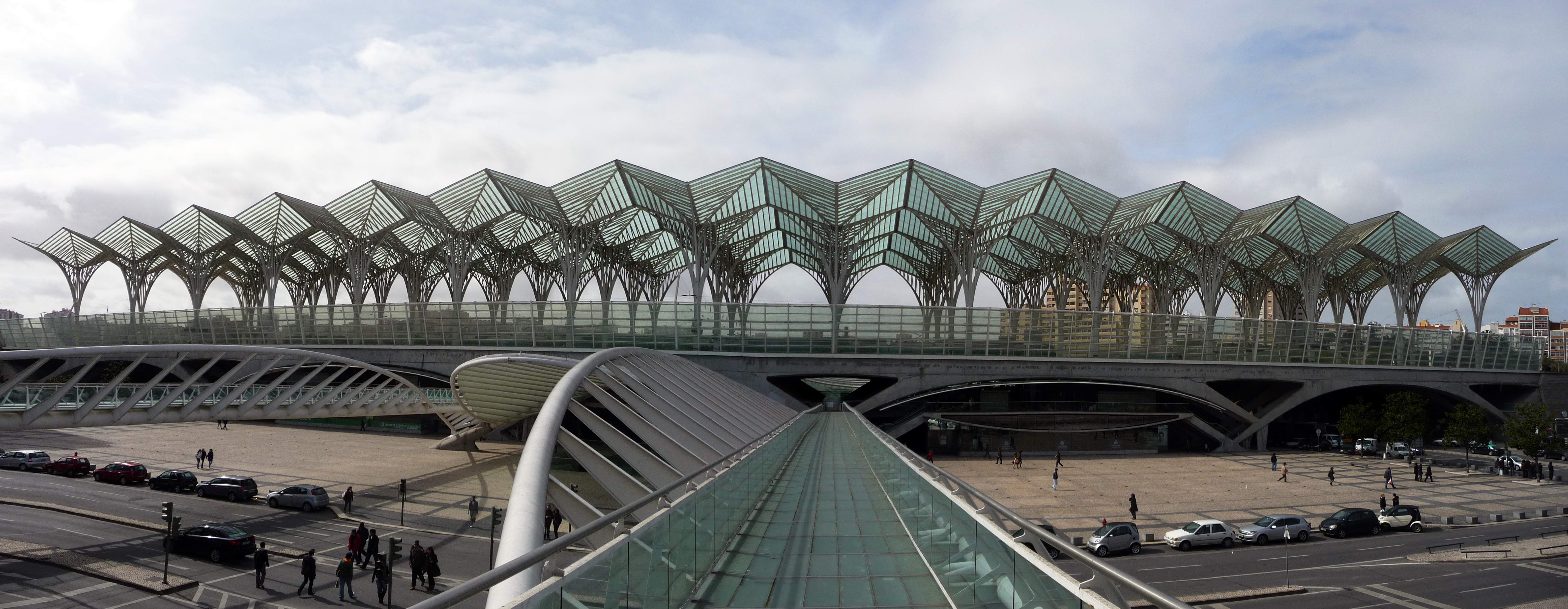
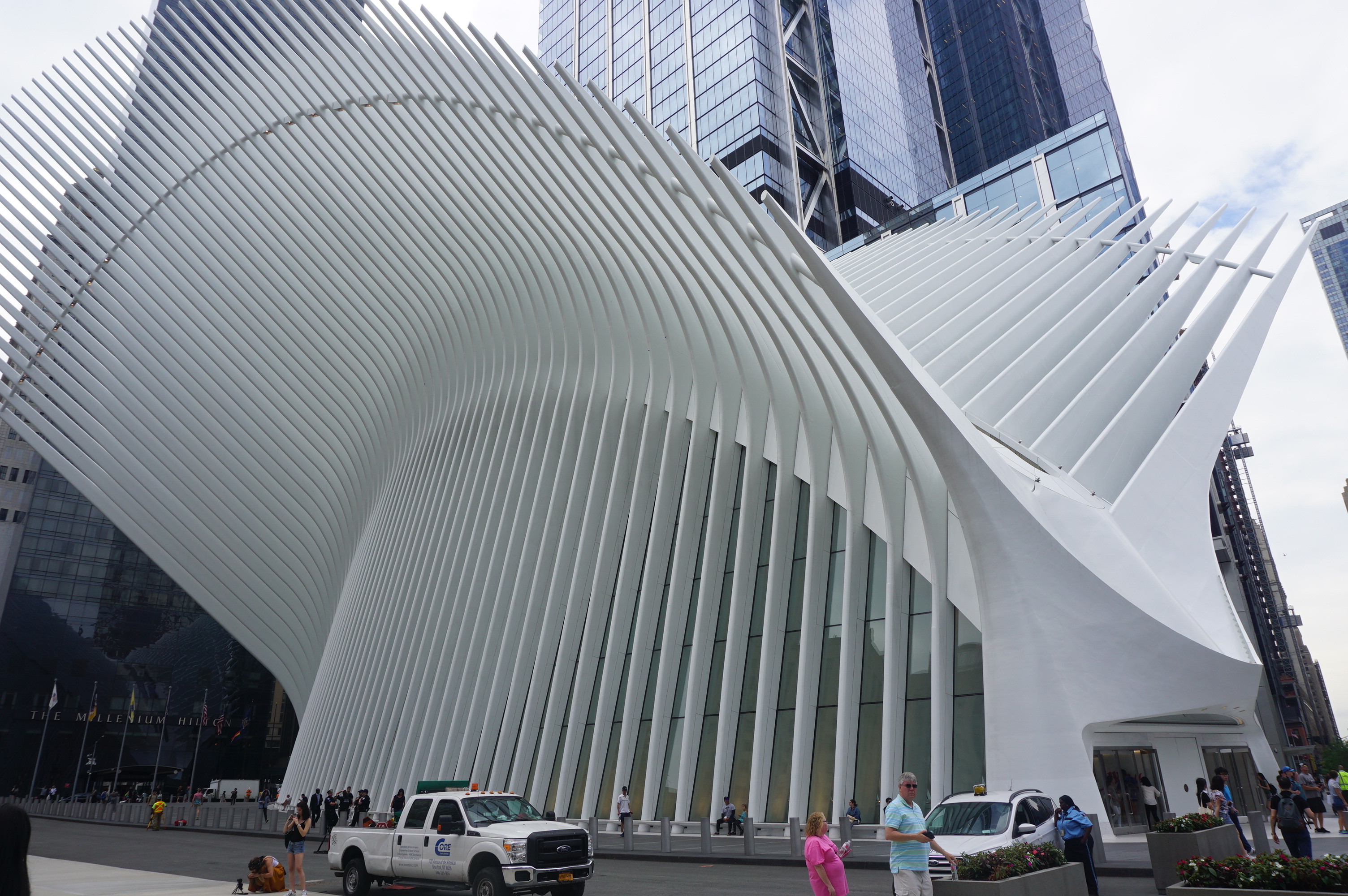
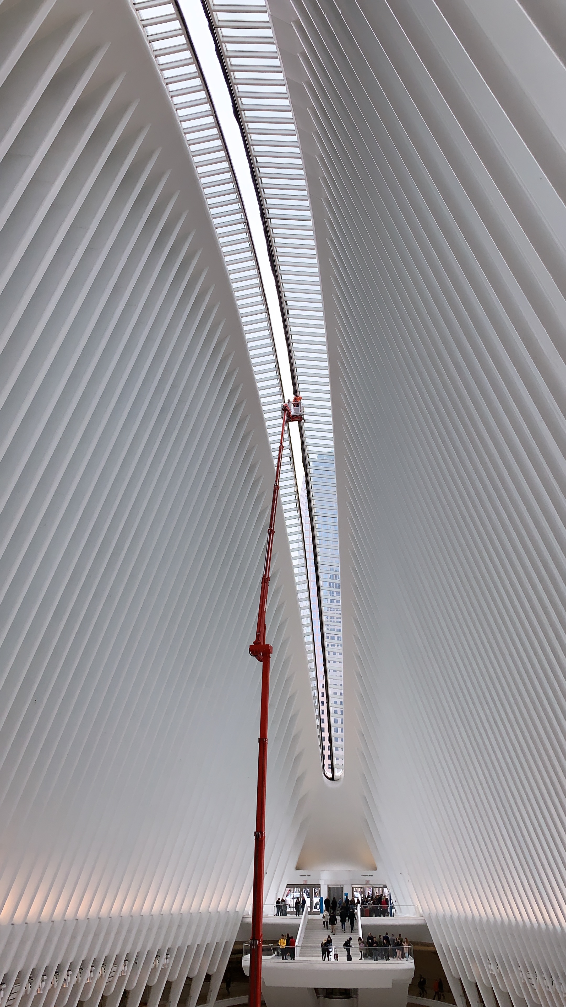
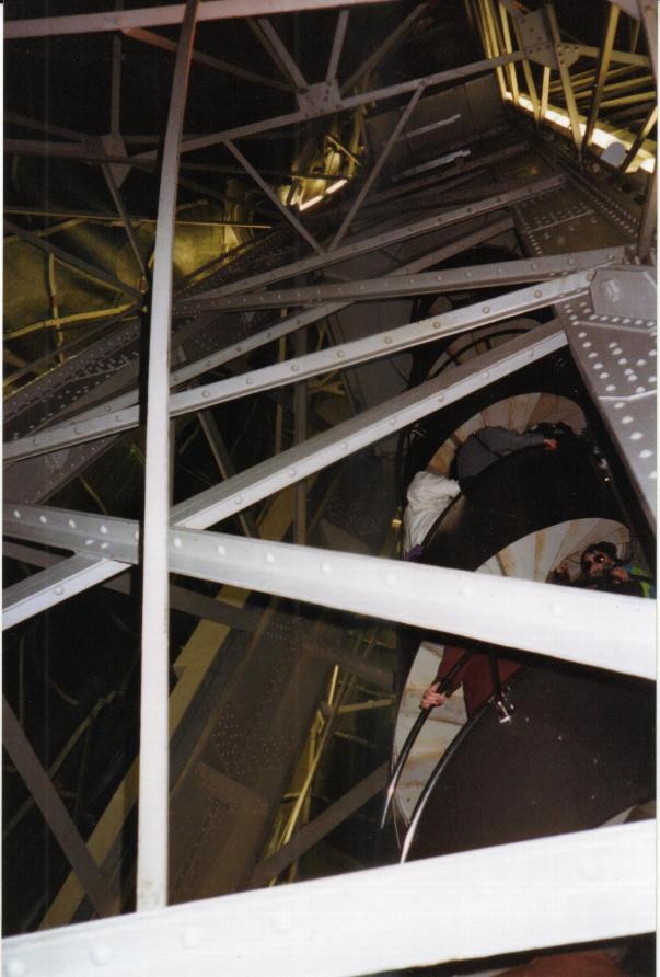
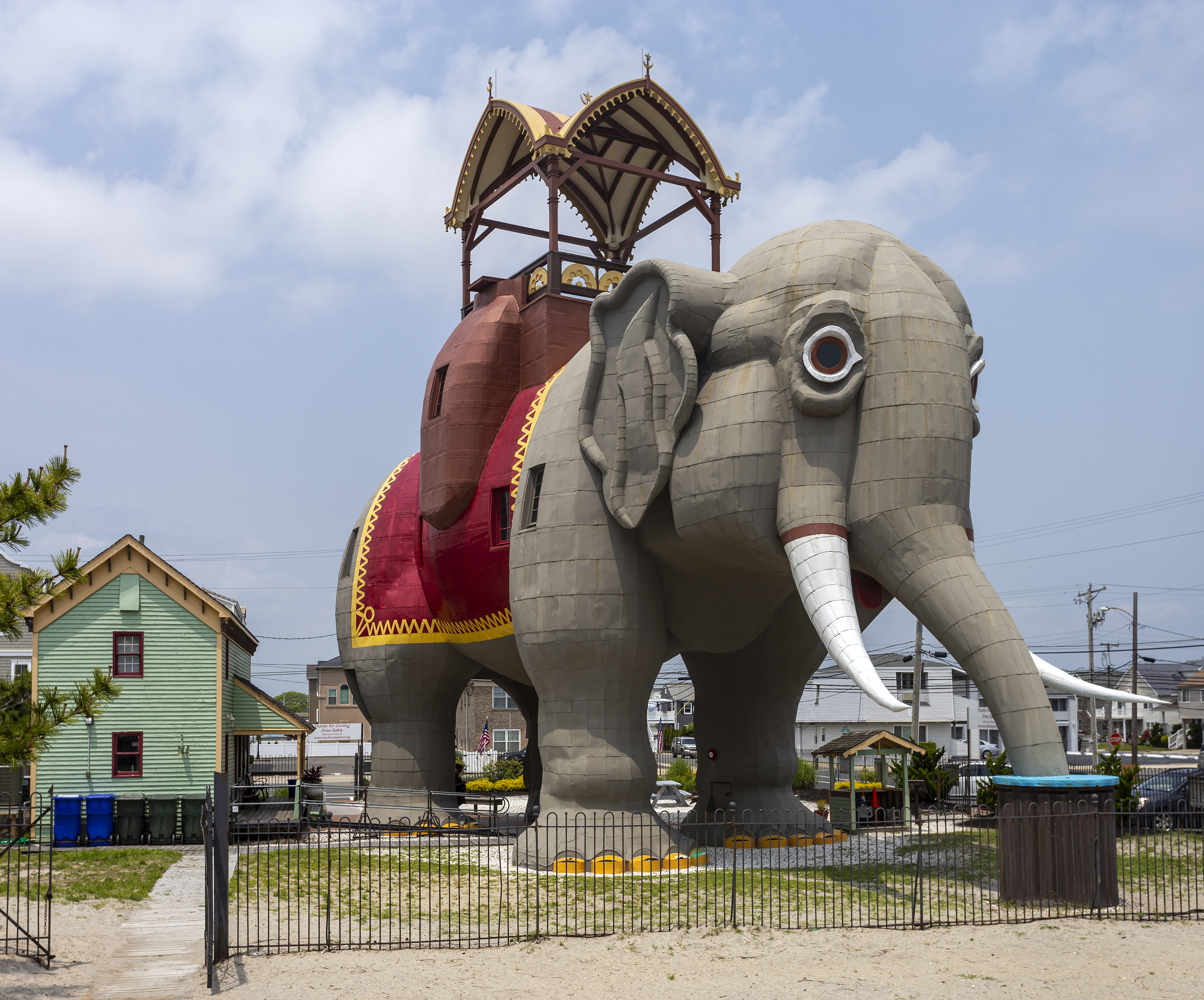
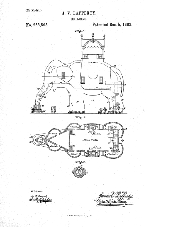
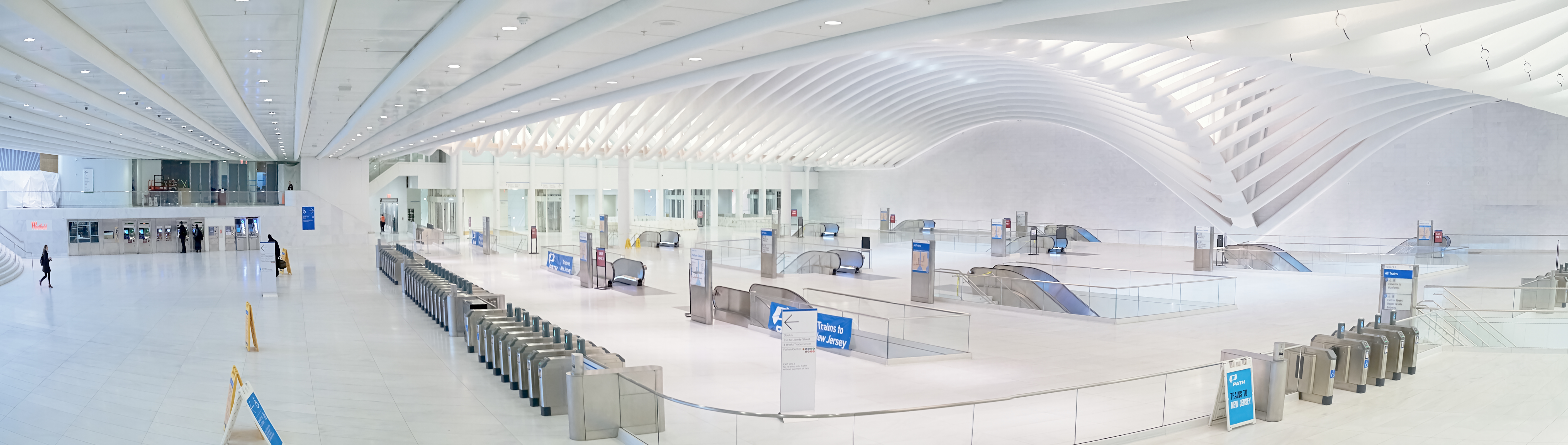
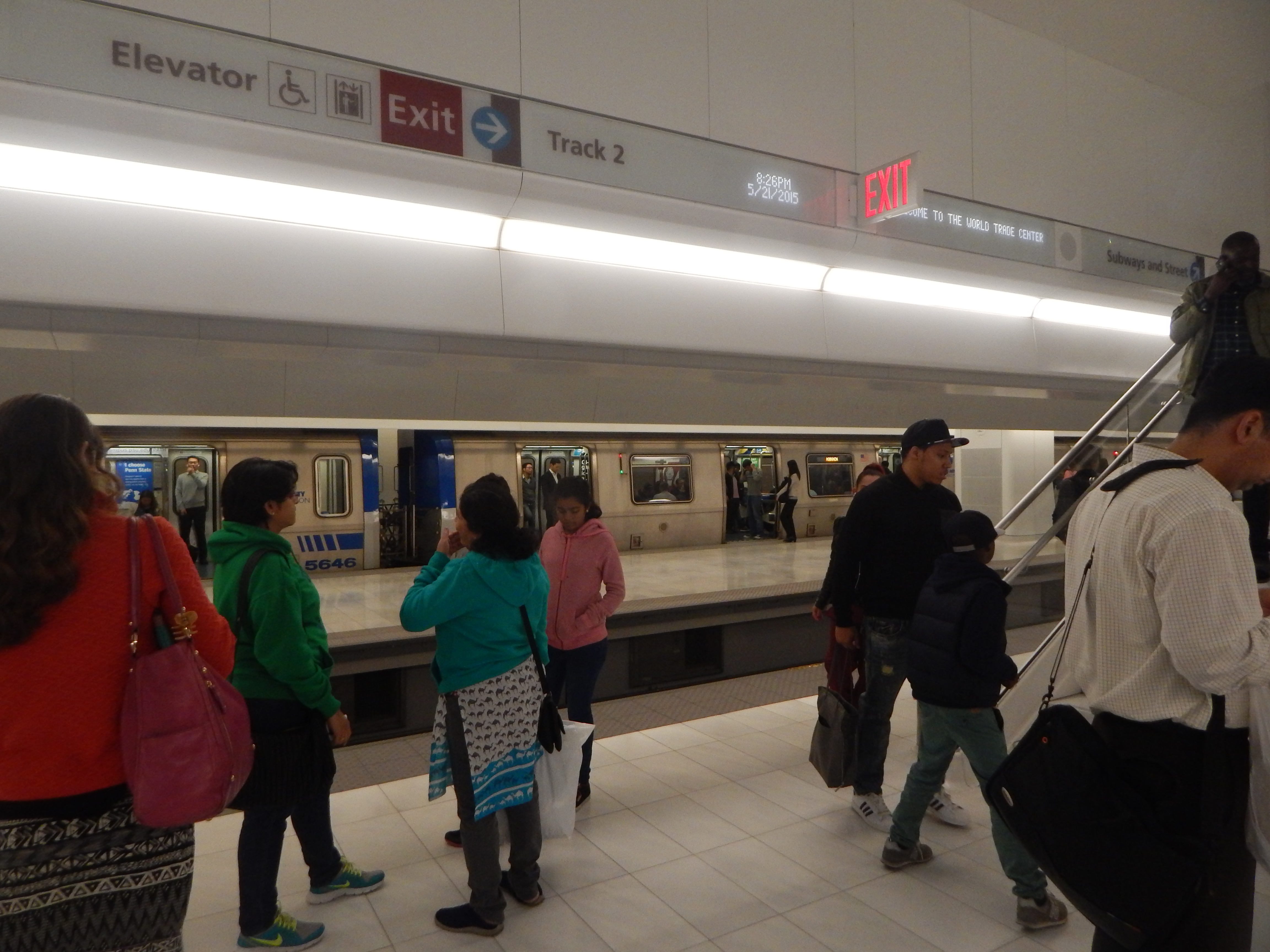
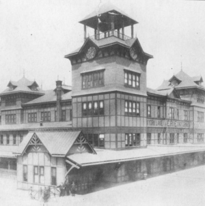
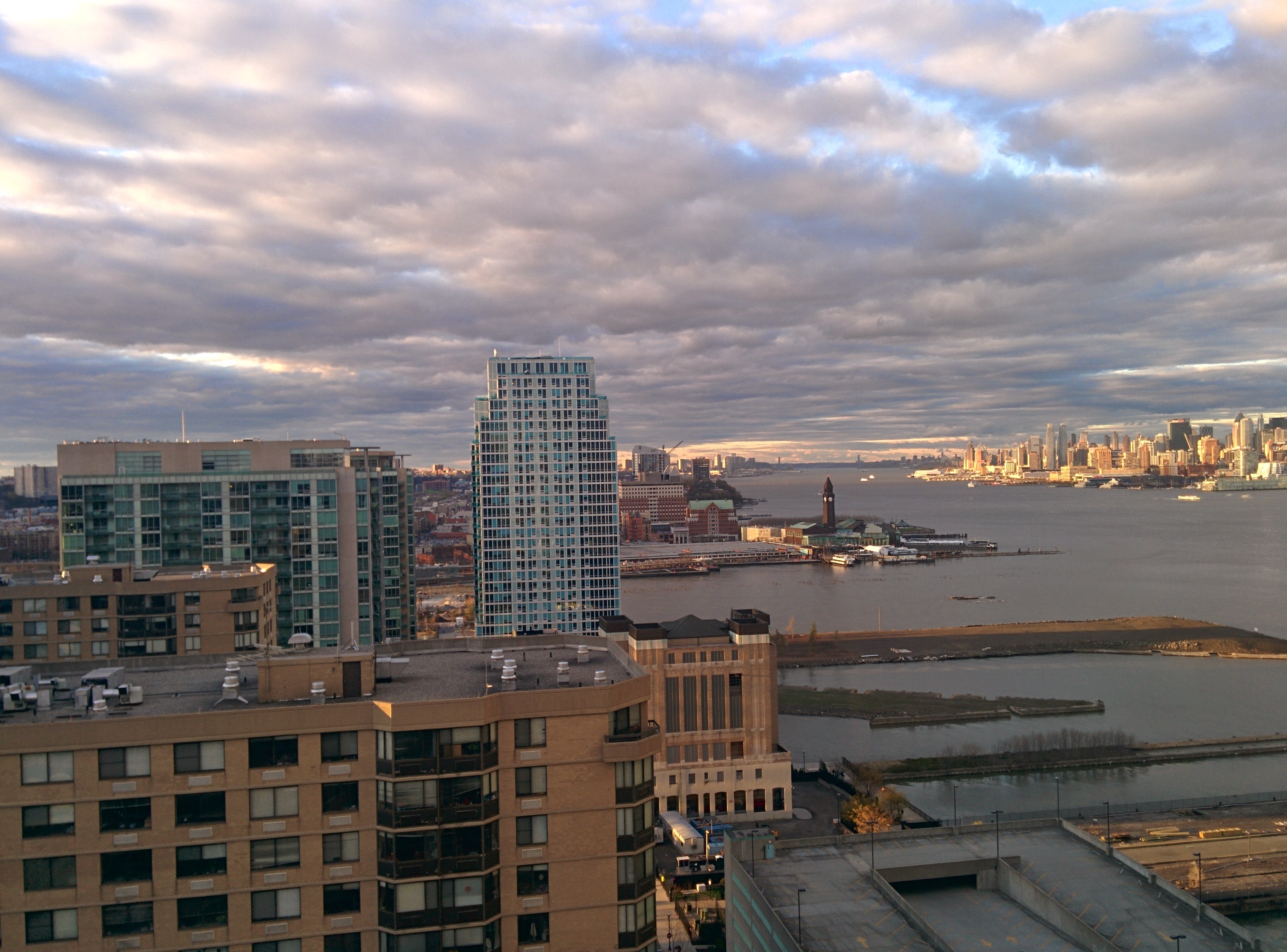
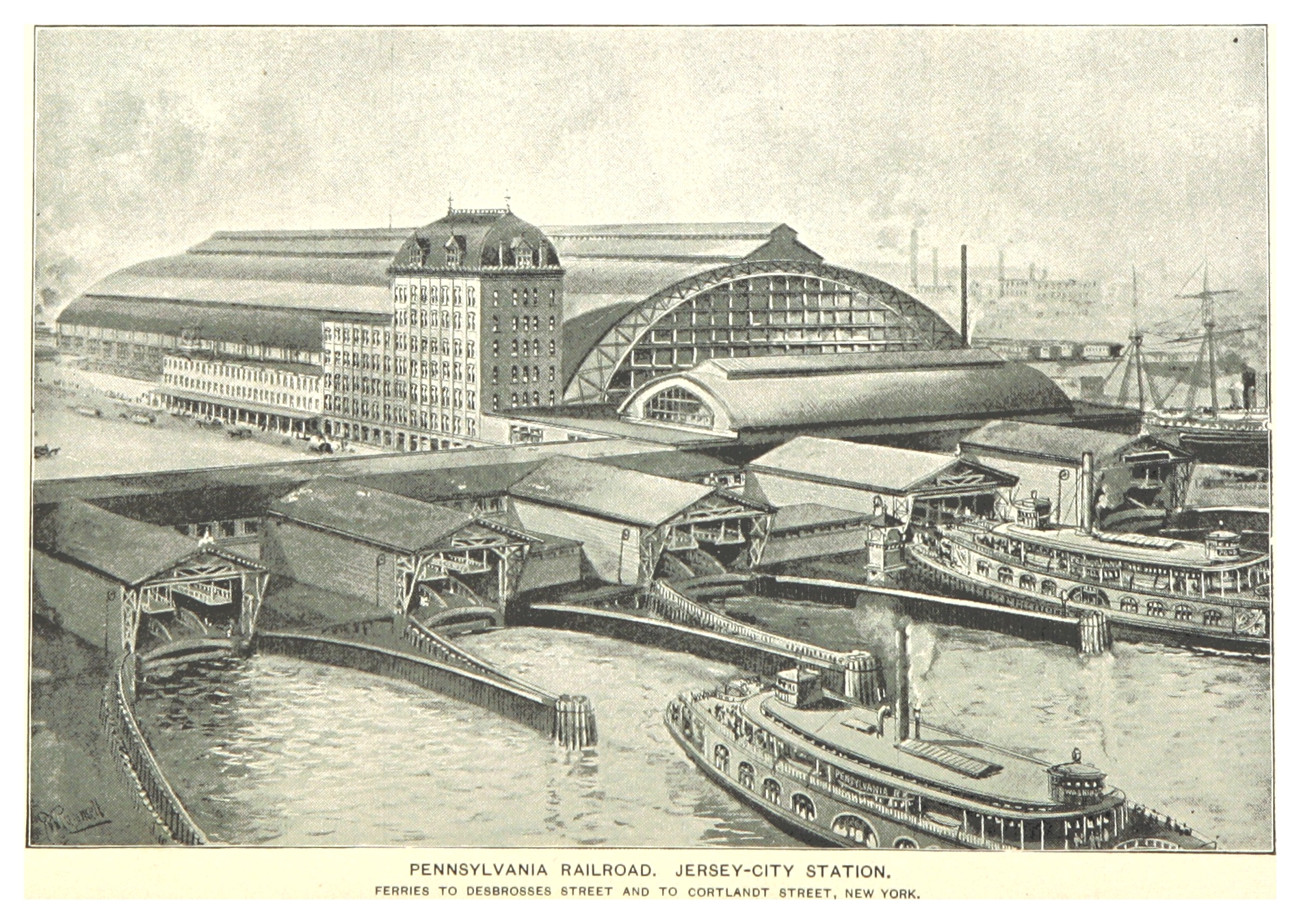
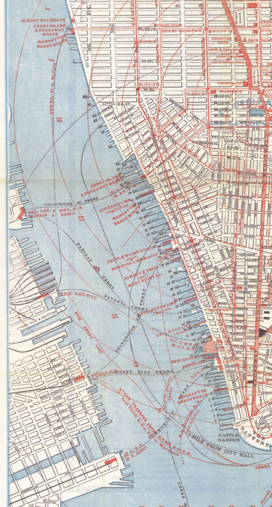
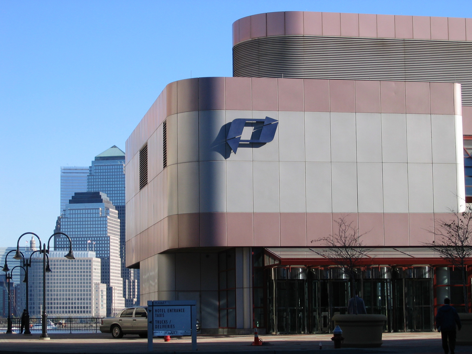
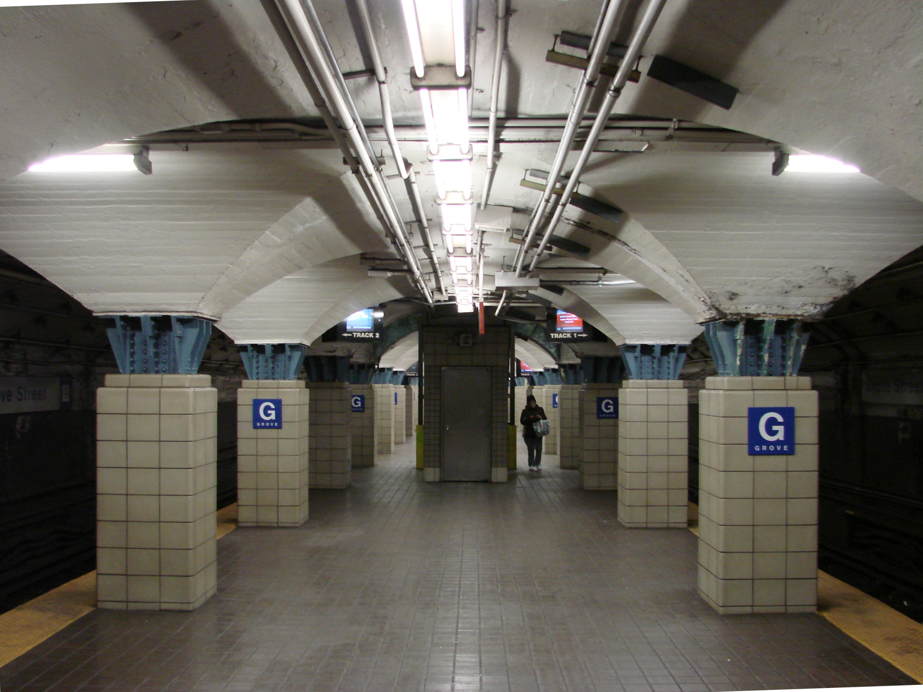
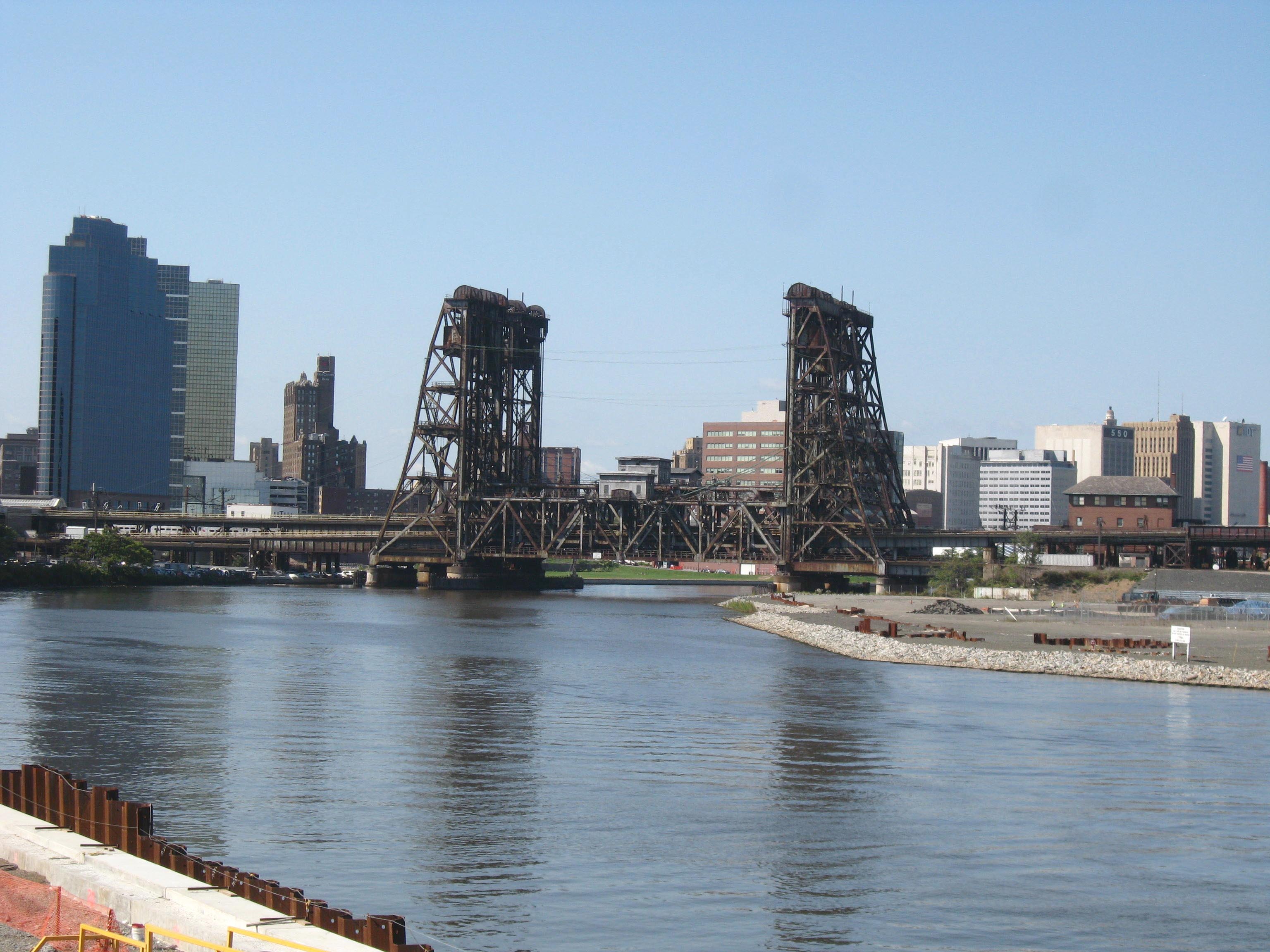
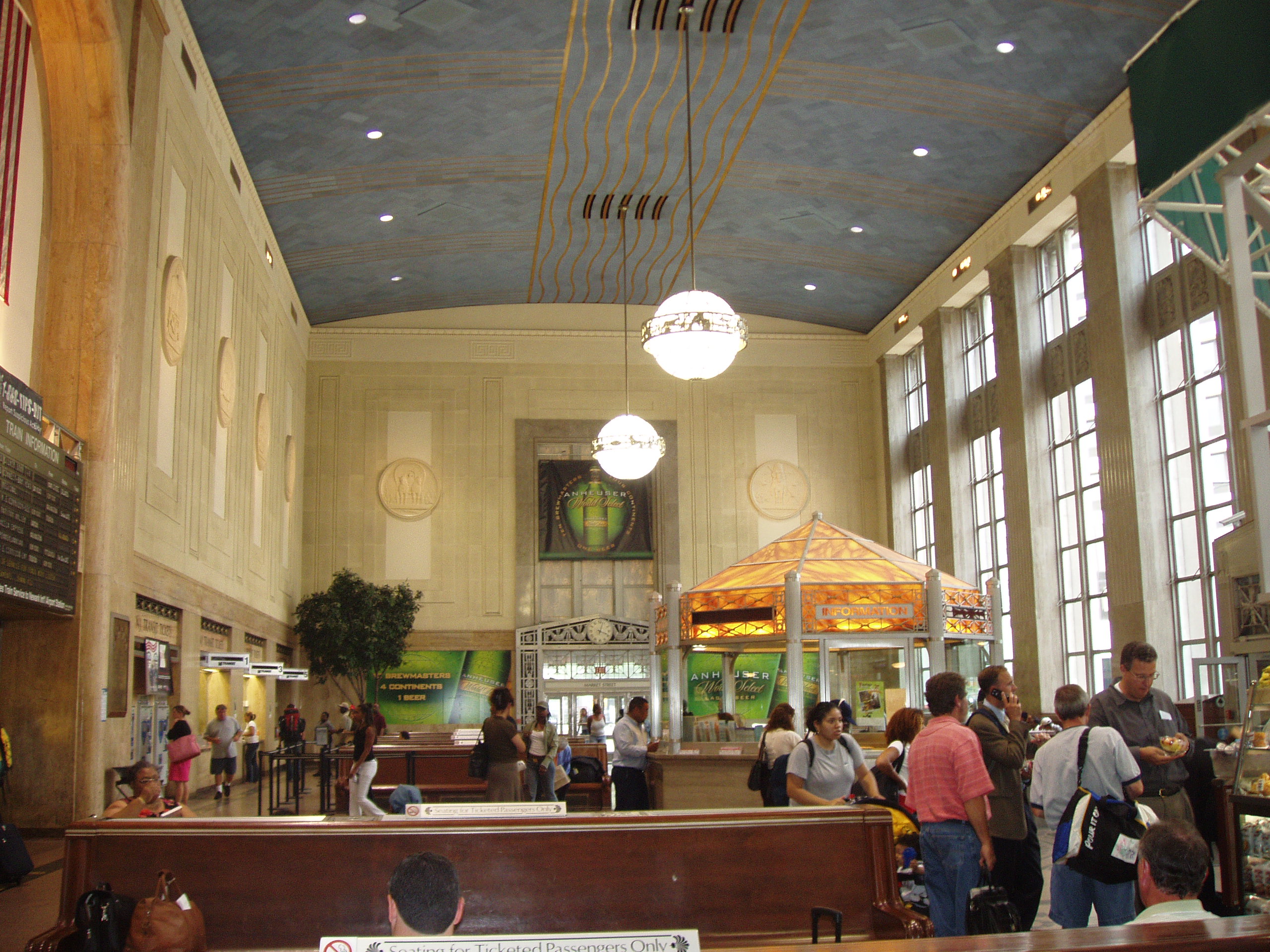