|
Reflections 2018
Series 9
September 3
Paris VII: Le Marais-Bastille-Promenade Plantée-Austerlitz-Métro Remnants
| | Day 6 Sa9 (First Part) Le Marais, Bastille, Promenade Plantée Our last full day in Paris (tomorrow will be a half-day) will be spent mostly on the Right Bank north of Cité. We've seen in the past a historic map showing the extent of former swampland on either side of the Seine. The swamps are gone, but the name of one well-known neighborhood, Le Marais, has maintained the memory of past hydrology, as its name means The Swamp. We refer once again to our attractions map:
https://parismap360.com/carte/image/en/paris-attractions-map.jpg
| | | | East of Cité, find the Place de la Bastille on the Canal Saint-Martin. Le Marais covers the area west of that up to the Hôtel de Ville. After we visit Le Marais, whose history is intertwined with that of the Bastille, we'll move on to discuss and visit the present Place de la Bastille, then continue on the Promenade Plantée, which is shown as a green line running southeast of the Opéra de la Bastille.
https://parisbytrain.com/wp-content/uploads/2014/01/paris-metro-geo-2014.pdf
| | | | We'll still need our Métro map. Our route to cross Paris today is simple: we take our line 9 from La Muette to Franklin D. Roosevelt, then line 1 to Saint-Paul, the stop before the Bastille stop we discussed when on the canal. | | | | Le Marais The Marais (ma.RÉ) is a historic quartier, like Montmartre, the Latin Quarter, Les Halles, Saint-Germain-des-Prés, and so many others. It's not an administrative quartier, of which each arrondissement has four. The fact that it lies on the Right Bank, just beyond Île de la Cité attests to the fact that it's a very old neighborhood. We'll stroll along Roman roads dating from the 2C, and then we'll be walking down at least a couple of streets that date from the early 13C. The Marais is also fortunately one of the few neighborhoods in Paris that retains much of its medieval layout. Haussmann was only minimally active here (see below) so the Marais was largely left alone, like the Rue Mouffetard. There are still many small back streets and squares in the Marais, some of which we'll visit. I also picture the Marais as being a center of 18C mansions and townhouses very similar to those we saw on Rue Jacob, where the Treaty of Paris was signed, so I feel no need to delve into those further. | | | | To my mind, the face of the Marais reflects the story of Charles V deciding to move here, which we already discussed on 2017/17. That story also includes the reason for the Bastille, so that will be part of this discussion. However, actually visiting the Place de la Bastille, where the Bastille used to be located, will be part of the next section. This is the historic map we used in that posting of Paris in 1380 (Map by Cédric Roms). Now that we'll actually be walking and studying these streets, you may want the same map to keep for reference in another window:
https://upload.wikimedia.org/wikipedia/commons/thumb/2/26/Plan_restitu%C3%A9_de_Paris_en_1380_-_ALPAGE.svg/2000px-Plan_restitu%C3%A9_de_Paris_en_1380_-_ALPAGE.svg.png
| | | | Charles V was the Dauphin, the heir apparent to the throne of France. He'd been living in the Palace on Île de la Cité (in green) when in 1358, when he was 20, the Palace was invaded and several of his counselors were killed right in his room. Because of this, he decided to leave Cité for ▲ a more secure location. In addition, he wanted to leave the bothers of the city and live ▲ outside the (Third) Wall of Philippe Auguste (the inner wall on the map). But the direction outside of Cité that he chose was probably based on the fact that he wanted ▲ easier access to the Château de Vincennes to the east (see the attractions map for the Bois de Vincennes). Though he became king in 1364 at 26, he started acquiring four residences in the Marais in 1361 and continued until 1366. He combined the four to form his grand residence, the Hôtel Saint-Paul (remember, Hôtel refers to any grand building). You can see on the historic map where this large building was, in light brown, right outside the old wall. | | | | | | His son, Charles VI, continued to use this palace, but it was abandoned by their successors for the Louvre and elsewhere and then used for other purposes. This abandonment lasted for 120 years, when it was finally demolished under François I, in the early 1500s, at a point where he was short of cash and sold off a number of older royal buildings. This was done by subdividing the land and selling off individual smaller lots. |
| | | | But once his new palace was now in place, where was that security he was looking for, now being outside the city walls? So this is when the (Fourth) Wall of Charles V was built, over on the right of the map. And we can now quote the earlier posting: We see Charles V's new royal residence, the Logis [residence] Royal de Saint-Pol built around, and avoiding, the church of Saint-Paul. Beyond the old Porte de Saint-Antoine, the Rue Saint-Antoine, once a Roman road, is now also within the walls, and leads to the Nouvelle [new] Porte Saint-Antoine in the new wall. And how to further protect all the mansions of the now extended Marais, and the new royal residence? You now see where La Bastille fits into this wall, and into history. Charles V decided to build what was first called the Chastel Saint-Antoine, chastel being an old word for château/castle. It was a strong fortress with eight towers protecting the gate. It was later called the Bastille Saint-Antoine, "bastille" being another word for "castle", and also related to "bastion". The name was finally shortened to just Bastille. It's known less for defending the eastern approach to Paris as for the state prison it became, which was stormed on 14 July 1789 in the Revolution. It was later demolished and replaced by the large Place de la Bastille . . . | | | | In sum so far, while there already was a Roman road crossing the Marais, it was Charles V in the 14C that expanded the Marais eastward and gave it more significance. But there's one more player that comes to the fore, none other than Haussmann. We said in 2017/18: Haussmann started . . . by building the Grande Croisée de Paris . . , the Grand Paris Crossing. . . . [L]et's use this preliminary, rough map showing in red some early boulevards (Map by Mark Jaroski) that he built in the 1850s. . . [W]e talked about Le Marais, and the Rue Saint-Antoine [(click)] that led to the Porte Saint-Antoine and later to the Bastille. Find that at the far right. Although that historic street was pre-existing, he did widen it, saving some historic buildings but demolishing others, along with some historic medieval side streets. He then extended the rue Saint-Antoine to the west . . , [and] cut through . . . the Rue de Rivoli to join the Rue Saint-Antoine, thereby creating an east-west axis across Paris. | | | | Now we've seen the Rue de Rivoli, whose name commemorates a 1797 victory over Austria of Napoléon I, as it runs along the Tuileries and Louvre. Back on our historic Marais map, find the Louvre and estimate the future route of Rivoli to the east, cutting across some very ancient streets. Slightly north of the Grand Châtelet, it will be cutting across the Place du Châtelet, the main intersection of his Crossing. Arriving in the Marais, it will cross a short distance north of the Saint-Gervais (Saint-Protais) church and then plunge into the heart of the neighborhood just south of the Rue du Roi de Sicile (King of Sicily Street), which still exists under that very name, and then plunge into the already wide Rue Saint-Antoine, forcing Saint-Antoine to be a de facto extension of Rivoli as his eastern axis. | | | | Now note the street just south of Sicile leading from the area of Saint-Gervais, today called Rue François-Miron. The original Roman road in this area dating from the 2C ran from Lutèce (Paris) along what is now François-Miron, then Saint-Antoine. It continued to the southeast, reaching Melodunum (Melun) and Agedincum (Sens, which we'll discuss in a moment). I know there's at least a partial Roman road between Sens and Auxerre, where our cruise will leave from, meaning the Romans could have traveled there from the Marais area almost two millennia ago. | | | | | | As for what is now called Rue François-Miron being ancient, in the 18C, a necropolis [ancient cemetery] was discovered underneath that street at house numbers 2 to 14, which is directly north of Saint-Gervais at the street's western end. Bones discovered dated to Roman, then later on, also Merovingian, times. (Compare with the Merovingian Franks in Montmartre, 5C-8C, in the last posting.) |
| | | | A Walk in Le Marais So we come up out of line 1's Saint-Paul (actually, sub-titled "Le Marais") station to find ourselves in a place that doesn't exist, at least not officially. To see what that's all about, we need a current Marais map:
http://2.bp.blogspot.com/_0-vDFYB3CPs/TJDmAFg_pRI/AAAAAAAAAHo/e93bv_Ya8qs/s1600/map+le+marais.jpg
| | | | This is actually the best version of an excellent online map of the Marais that is clickable for details. But I have to apologize for it obviously being a "used" map. Someone scribbled their route in red right down the modern center of the Marais, along Rivoli/Saint-Antoine. But at least that shows us where Haussmann's eastern axis runs. | | | | You see the Métro stop couldn't be better located in medias res, right in the center of things. It's at the church everyone calls Saint-Paul, but which is technically Saint-Paul-Saint Louis, the second double-named church we've come across here. The stop is physically in the center of what is universally called Place Saint-Paul, but it's actually in a slender wedge of land serving as a traffic island between a large street and small street. Let's see what that's all about on the modern map. | | | | You'll find Rue François-Miron, the route of the old Roman road, starting near Saint-Gervais and coming in this direction, to meet the continuation of the Roman road, Rue Saint-Antoine. That's the smaller street to the south of the station. Then you see Rue de Rivoli (still south of Sicile) bulldozing its way into the intersection on the north side and bullying its own way to merge with Saint-Antoine. So right here, we have the 19C impinging on the 2C, which is fabulous stuff to contemplate, as long as you're in the know. | | | | This is the exit from the Saint-Paul station (Photo by Djampa) in the center of the so-called "Place Saint-Paul". The exit is quite simple and confirms that most Métro stations today lack those Art Nouveau Guimard exits we saw in Montmartre. It also shows it has an escalator, but only in the direction we're arriving in, with none in the other direction. But what's marvelous about this view is that, as we look due west, we first see Haussmann's broad Rue de Rivoli coming toward us on the right—this last extension was completed in 1854—to meet Rue de Saint-Antoine behind us. But what's better still, as we look to the left of that narrow yellowish building (click), we see the narrow Roman road, now known as Rue François-Miron, also coming toward us to join Saint-Antoine as it always had done, since the 2C. We can now understand better why this narrow traffic island called Place Saint-Paul exists, and the history behind it.
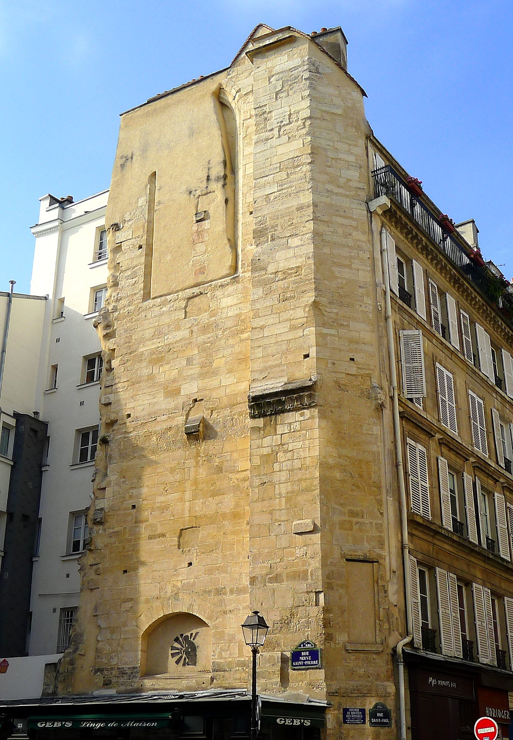
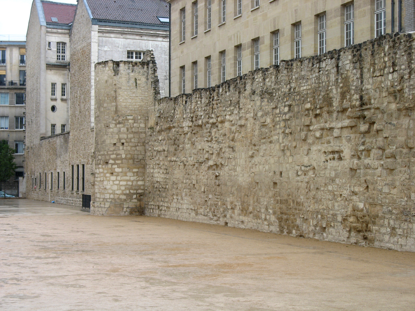
| | | | This is another view, again looking west down broad Rue de Rivoli (Photo by Djampa), with Rue Saint-Antoine behind us. And again, to the left of that narrow, yellowish building, we can see (click) narrow Rue François-Miron joining the Place Saint-Paul. | | | | From here, it's just steps to the Église Saint-Paul (Photo by Parsifall). The 17C church, showing both Italian and French architectural styles, is of some interest. The first church of Saint Paul in this area was called the Chapelle Saint-Paul-des-Champs (Chapel of Saint Paul in the Fields), built around 632-642 at Rue Saint-Paul (see modern map) and the first eastbound street to the south, Rue Neuve-Saint-Pierre (New Saint Peter Street, not named on map; also find the old church in red on the historic map.) | | | | Once again, we see the fact that it was away from Lutèce placed it "in the fields", as with Saint-Germain-des-Prés. It was replaced by a parish church in 1125, which was in turn sold and destroyed in 1796 during the Revolution. This is the only vestige of that church (Photo by Mbzt)—click to read both street signs. It's always of interest to see an ancient ruin retained simply because it had been recycled as the fourth wall of a later structure. | | | | Finally, in 1802, the church was transferred into the nearby Jesuit chapel of Saint Louis, built 1627-1641, resulting in the present double name. This is an interior view (Photo by Pline). We then leave the church via the side exit to the Rue Saint-Paul (see map), and find that the now-gone Hôtel Saint-Paul remains of interest. On the modern map, it would have run between the Rue Saint-Antoine and the Quai des Célestins on the river, and between Rue Saint-Paul and Rue du Petit-Musc. Compare this with the historic map. With the subdividing of the land of the Hôtel Saint-Paul, Rue Beautreillis ("Beautiful Trellis") was put through in a N-S direction (see map). Its name is attested to as of 1555 and is based on one of the buildings that replaced the Hôtel Saint-Paul, the Hôtel de Beautreillis, which in turn got its name from all the trellises against its garden walls. | | | | Three short E-W streets also cross the grounds. Already mentioned is the Rue Neuve-Saint-Paul, which was pre-existing. It had been the 16C Passage Saint-Paul, connecting the old Saint-Paul cemetery directly with surrounding streets without needing to go through the old church. I think it appears in an L-shape on the historic map. Later it was extended to the east. The Rue Charles-V was cut through in 1552. | | | | But the most interesting of the three is also a preexisting one, the Rue des Lions-Saint-Paul. You'll find it on the historic map already crossing the property. It had been a passage back in the day, then was opened as a street between 1551 and 1564. The purpose of the passage was to separate the residence of the king to its south from the residence of the queen to its north. The reference to lions is either based on the lions that were painted on the doorway of the main palace entrance in 1364, or to the menagerie maintained by both Charles V and Charles VI. Street names are fascinating. | | | | Wall of Philippe Auguste From Rue Saint-Paul we turn right onto Rue Charlemagne and then left on Rue des Jardins-Saint-Paul (not named on modern map) before a linear park area, where we find ourselves facing an exciting artifact, the longest surviving portion of the Wall of Philippe August (Photo by Sam Spade). It was built between 1190 and 1213 and abuts a high school, the Lycée Charlemagne on Rue Charlemagne (to the right), on its side facing Rue des Jardins-Saint-Paul. The building originally served as the home of the Order of the Jesuits, while the lycée itself was founded by Napoléon. Once again we see an artifact that survived because it had been recycled as the fourth wall of a later building. This was the Third Wall around Paris and the oldest whose route is known precisely. This stretch is intersected by two round towers, whose shapes can be made out at either end. The Barbeau tower is to the south (left), and on the north (right), the tower is the Saint-Paul postern, a postern being a back or side entrance. This is a detail of the south end (Photo by CJ DUB). Now find this wall segment on the historic map, plus the streets that got us here from Rue Saint-Paul. It's always an advantage to the thrill of history to be able to flip between maps like these, somewhat similar to seeing before and after pictures.
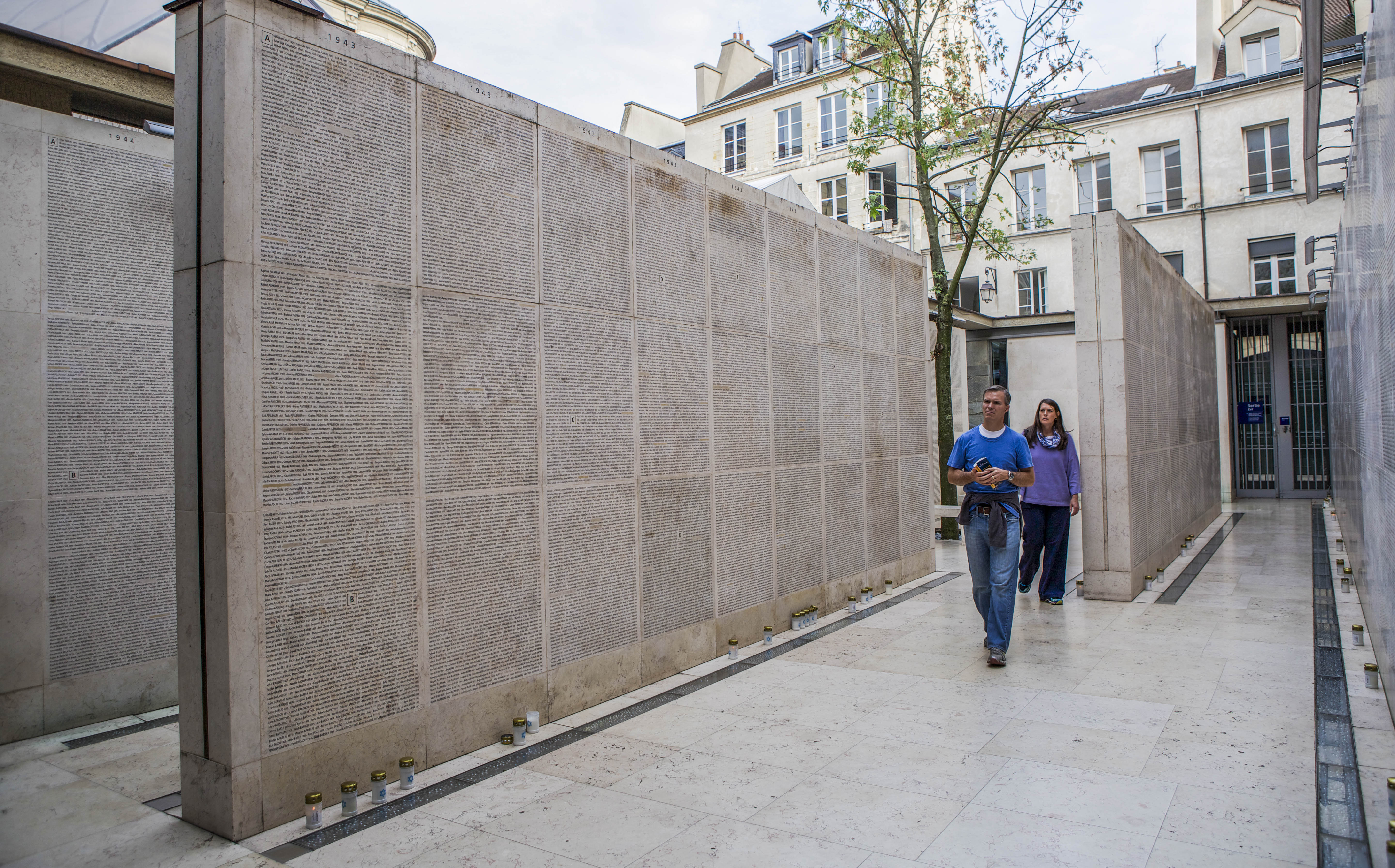
| | | | Before we move on to our next stop, we can take a short detour. It's just a short block further to a riverside park area along the Quai des Célestins, where we can enjoy a nice view of the Île Saint-Louis across a channel of the Seine. These are buildings (click) along the Quai d'Anjoy (Photo by Tangopaso) on the north side of the very residential Île Saint-Louis. | | | | Hôtel de Sens We backtrack just a few steps to the Wall and go west a bit and come to a building I think is gorgeous, the Hôtel de Sens (Photo by Mbzt)—pronounce the S at the end of Sens. As both the map and picture show, the building is located on a triangular corner, giving it a particular charm.
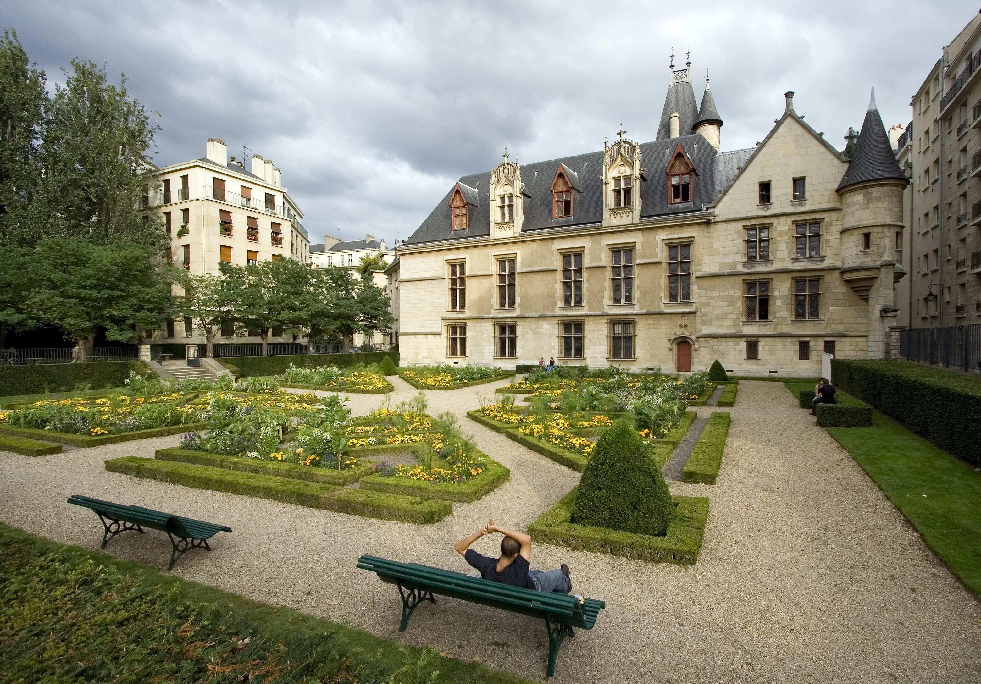
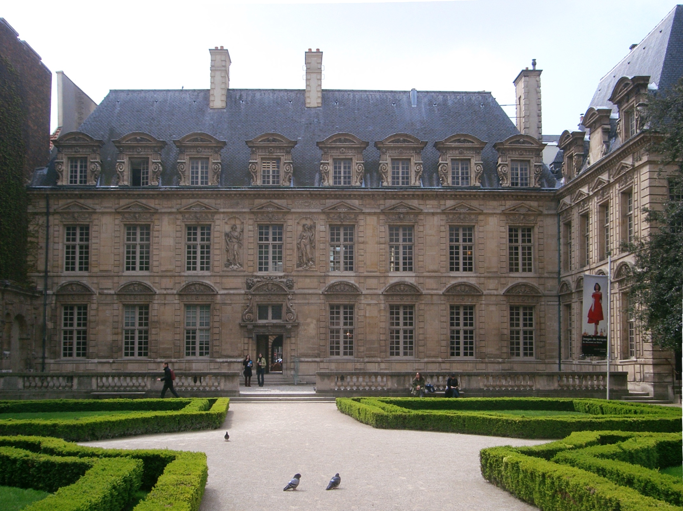
| | | | You'll recall that in 2018/6 we mentioned the Hôtel de Cluny, near what is now the Cluny-La Sorbonne station, as having been built partially over the Roman baths, because [a]bout 1330 . . . the abbot of Cluny-en-Bourgogne bought the Roman ruins and built a residence for abbots visiting Paris. This residence, along with the Hôtel de Sens on the Right Bank . . . are the only two large 15C private residences in Paris. And so here we are at the other of that pair, the Hôtel de Sens in the Marais. | | | | The explanation is this. Paris didn't become its own archbishopric until 1622. Before that, Paris was a dependency of the Archbishopric of Sens, which as we said above is southeast of Paris on the road to Auxerre. Therefore, the archbishop of Sens was also the personal counselor of the kings of France, and as such his responsibilities brought him to Paris often. On that basis, he acquired what then became the Hôtel de Sens in 1345, which explains why the full name of the building is the Hôtel des Archevêques de Sens (Mansion of the Archbishops of Sens). The original building was replaced by the current one, built between 1475 and 1519. Once Paris became its own archdiocese in 1622, this building lost its reason for being, and declined. It was taken over at the time of the Revolution and sold in 1797, to be privately owned during the entire 19C, housing shops, workshops, or factories. The city acquired the building and thoroughly restored it in 1930. Since 1961, it's housed an art library. This is the view from the garden in the back (Photo by Nelson Minar). | | | | Mémorial de la Shoah As we move west in the Marais, we enter Jewish Paris, both its joys and tragedies. But we start with its tragedies. Our map is slightly out of date, as it indicates where we're going by its old name, the Mémorial du Martyr Juif Inconnu (Memorial to the Unknown Jewish Martyr). That's still located there and part of the memorial, but the scope of the memorial has been extended, and it's now called the Mémorial de la Shoah (Holocaust Memorial), with French using the Hebrew word shoah ("catastrophe"). | | | | Our only problem is that today is Saturday, the sabbath, and the memorial is closed. So we won't see all of it in person, but will be helped now by online pictures. We will see the part that's outside in the side street, but through the front gate we can only see about half of the circular monument in the forecourt. We see it now fully, and find that it's an impressive monument listing the death camps and Warsaw ghetto (Ghetto de Varsovie). For later reference, note the building across the street (Photo by Guilhem Vellut / CC-BY). | | | | Apparently at another location in the forecourt is the Mur des Noms (Wall of Names); here is a more detailed view. The birth dates (click) indicate the age of the person, from young to old (Both photos by Ninaraas). The names are cut directly into stones brought from Jerusalem. The stated purpose of the Wall is to keep alive the memory of the 76,000 Jews deported from France, both French and foreign, of which 11,400 were children. The names are grouped by year, from 1942 to 1944, and in alphabetical order. The archival service keeps updating the names. If it discovers the names of other Jews deported from France, or finds a spelling error, the names are inscribed at the end under "Names of those Deported Discovered after Inscription". Those who wish to leave a remembrance for names may leave candles, flowers, or pebbles at the bottom of the wall, as shown in the first picture. | | | | Underneath the forecourt is a crypt where the Mémorial du Martyr Juif Inconnu (Memorial to the Unknown Jewish Martyr) is located, dedicated to all Jews who perished in WWII, not just French Jews,. It's in the form of a Star of David in black marble into which have been placed the ashes of Jews exterminated in the death camps and in the Warsaw Ghetto, mixed with the soil of Israel. An eternal flame (click) burns in homage (Both Photos by Guilhem Vellut / CC-BY).
http://static.panoramio.com/photos/large/5036953.jpg
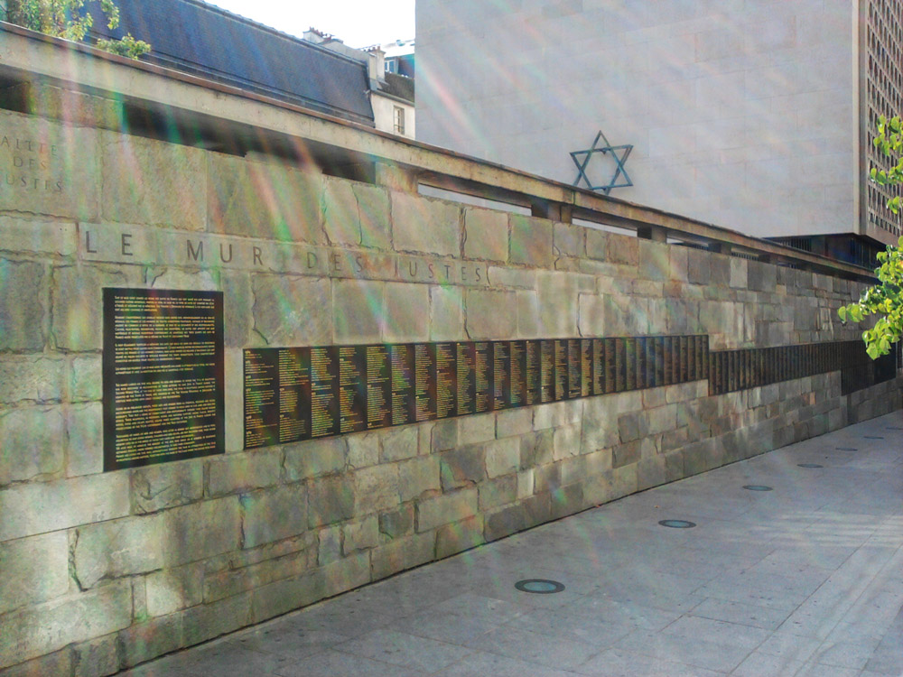
| | | | The memorial is quite compact in size, as seen above. We see here the closed grill in front that blocked our entry on arrival. The treed area to the right, though outside the memorial proper, is also a memorial area. Its theme is parallel to that of the Museum Memorial of Yad Vashem in Jerusalem, which has awarded the title "Righteous Among the Nations" to non-Jews around the world who helped save Jews during the war. Here in Paris, this side street has now officially been renamed the Allée des Justes de France (Walk of the Righteous of France) for those individuals, either French or acting in France, who aided Jews in WWII. | | | | However, the above picture of the Allée is dated, because it's lacking the lists of names. This newer picture shows the Mur des Justes (Wall of the Righteous) with the names inscribed on plaques along the Allée (Photo by Marcvjnicolas). The names are by year, and in alphabetical order. There are presently 3,899 Justes de France, though, as of the 2014 data I have, only 3,853 are inscribed on the wall. An update may have since been done. The first picture below shows a grim-faced President Emmanuel Macron visiting the Wall in 2017.
https://www.causeur.fr/wp-content/uploads/2017/05/emmanuel-macron-memorial-shoah-paris.jpg
https://www.fcpe75.org/wp-content/uploads/2015/12/Francois-Couperin-1-e1475426759265.jpg
| | | | I'd said earlier to take note of a building across from the memorial, and above is a better view of it. You can see the Allée, and the two street signs showing the change of name of the Allée. It's a middle school, the Collège François Couperin, and above the double entry it says it's an École des Garçons, a Boys' School. I mention it only because, turning away from the Wall, I immediately noticed, to the right of the right-hand blue door, this engraved plaque:
http://francerevisited.com/wp-content/uploads/Jewish-children-plaque-Allee-des-Justes.-Photo-GLK..jpg
| | | | It translates as: "Arrested by the police of the Vichy Government, accomplices of the Nazi occupiers, more than 1,000 children were deported from France from 1942 to 1944 and killed at Auschwitz because they'd been born Jewish. More than 500 children lived in the 4th Arrondissement, among them, students from this school. LET US NEVER FORGET THEM." | | | | It's particularly jolting because it's directly opposite the memorial, yet remains a school that goes on functioning as ever to this day. I saw another school with a similar plaque, and there were many houses listing former residents who'd been deported. Thus signs of tragedy remain peppered into this community amid the joys of life. | | | | There are many similar signs to be seen online, but, though I never actually saw it, I chose this more uplifting one (Photo by Joanna Bourne) because it commemorates one of the Justes de France: "To Joseph Migneret, teacher and principal of this school from 1920 to 1944, who, by his courage and at the peril of his life, saved dozens of Jewish children from deportation. His former students, in appreciation." Adding poignancy to the inscription is the date 1944, at the height of the deportations, with no further clarification offered. Did Migneret survive? Did he perhaps just lose his job? Or worse? And where was this school? | | | | And so I just consulted the website of Yad Vashem in Jerusalem and their list of the Righteous Among the Nations—you can do anything online nowadays--and I have the answers. Though I was just going to show the plaque, I have additional information that I'd like to offer. We can attempt to envision the Marais under Nazi occupation and get a sense of just how dangerous these streets were at that time. | | | | Find on our map the spot just north of here where we'll be shortly, the corner of Rue des Rosiers and Rue des Écouffes. The next right turn off Rosiers is (unnamed on the map) the Rue des Hospitalières-Saint-Gervais, and on its right side was and is still the elementary school named after the street it's on, the École élémentaire des Hospitalières-Saint-Gervais. It descends from a pair of schools, one for boys at #6, one for girls at #10, established in 1819. They were the first Jewish schools established in Paris and were financed by the Baron de Rothschild. Later they became secular schools financed by the city of Paris, but most of the students continued to be Jewish. | | | | | | A curiosity: note that the next street west is the Rue Vieille du Temple (Old Temple Street), then compare that with the historic map. You'll find that that entire brown area, a former market, was up against the Wall of Philippe-Auguste, and to this day, a wall fragment is still visible in the play area of #10. Apparently the route of that Wall ran either along or near Rue des Francs Bourgeois (on the new map). |
| | | | Joseph Migneret, as the plaque mentions, was a teacher and principal, apparently in the boys' school, from 1920 to 1944. During the Holocaust 165 of the children of the Hospitalières-Saint-Gervais School were deported. None survived. The roundups of the Jews practically wiped out the school.
http://www.ajpn.org/images-justes/1244354291_migneret_1934.jpg
| | | | This picture shows Migneret in 1934 with a class of boys, roughly a decade before the deportations. His students during the 1942-1944 deportations would have been of a similar age. This group of boys would have by then been teenagers, and one wonders what their fate was. | | | | The deportations starting in July 1942 had a severe affect on the students and teachers of this school. At the time of the rentrée, when school started again in October 1942, only four students showed up. | | | | When Migneret first found out about the deportations, his students, his former students, and their families turned to him for help. He helped them in any way he could. He didn't just sympathize with their plight, he decided the situation called for action. He became active in an underground network, part of the Résistance, that provided false papers to aid Jews on the run. He was living in a small rented apartment at 71 Rue du Temple, just north of Rue Rambuteau, west side. I specify that so precisely so that you can find it on our map in order to continue to envision that these were real places, right here in the Marais. In this apartment he hid students, in some cases for more than two years, as he continued to provide false papers for others. A list is available of families sheltered, hidden, aided, or saved by him. Yad Vashem documentation specifies the work he did as supplying basic goods, hiding, providing forged documents, illegal transfer, arranging shelter. | | | | The good news is that Migneret survived the war, dying in 1949, though at the age of only 61. But that's tempered by what one of the survivors said of him, that he died de tristesse au constat de ce qui a été fait à ses élèves (of sadness knowing what had been done to his students). The school has become a place where each year, former students, people close to those that were deported, and local residents gather in his memory. | | | | I've also just now learned that a number of back yards of buildings right where we'll be walking, along Rue de Rosiers's north side up to Rue des Francs Bourgeois, have been consolidated into a garden, the Jardin des Rosiers – Joseph-Migneret. This is less than a block away from the school. And given that we've determined that the Rue des Francs Bourgeois was the site, or near the site, of the Wall of Philippe-Auguste, which peeked into the school grounds, we should not be too surprised to see that the garden has the vestige of a tower from that Wall, as well as a vestige of perhaps the same tower that had once been recycled into a chapel, the sort of recycling we've seen before (All three photos by Mbzt). | | | | It's now time to walk from the museum to the center of Jewish life today, and to do so, it works out nicely to take the Roman road. At the corner we turn right, into the Rue François-Miron, and return to the Place Saint-Paul. We then use Rue Malher to reach Rue des Rosiers. | | | | Rue des Rosiers & Rue des Écouffes Presence of a Jewish community in Paris is ancient. It's noted by the expulsion of Jews in 1306 and again in 1394, reflecting in growth and decline of populations. Between 1881 and 1914 there was a strong increase in Jewish immigration of those fleeing persecution in Romania, Austria-Hungary, and Russia, at which time some 20,000 Jews settled in the Marais. Thus the community is strongly Ashkenazi, but recent research shows that the Sephardic community is also present. | | | | | | I find it interesting that French has borrowed from English the word Yiddish. In English it refers only to the language. That's true also in French, where it isn't capitalized: yiddish. I've also read there's an alternative spelling in French, suggested by linguists, yidich, but I've never seen it anywhere. But what I find a bit amusing is that French has taken the word a step or two further. Parallel to words like anglophone and francophone, French describes Ashkenazi Jews as being yiddishophone, down to the connecting O in the middle. Also, French uses the word as an adjective. We'll shortly see a store with writing on the door that says they sell pâtisserie yiddish. But English speakers would never say "*Yiddish pastries", but rather simply "Jewish pastries". It's the same for "Jewish cuisine", not "*Yiddish cuisine". |
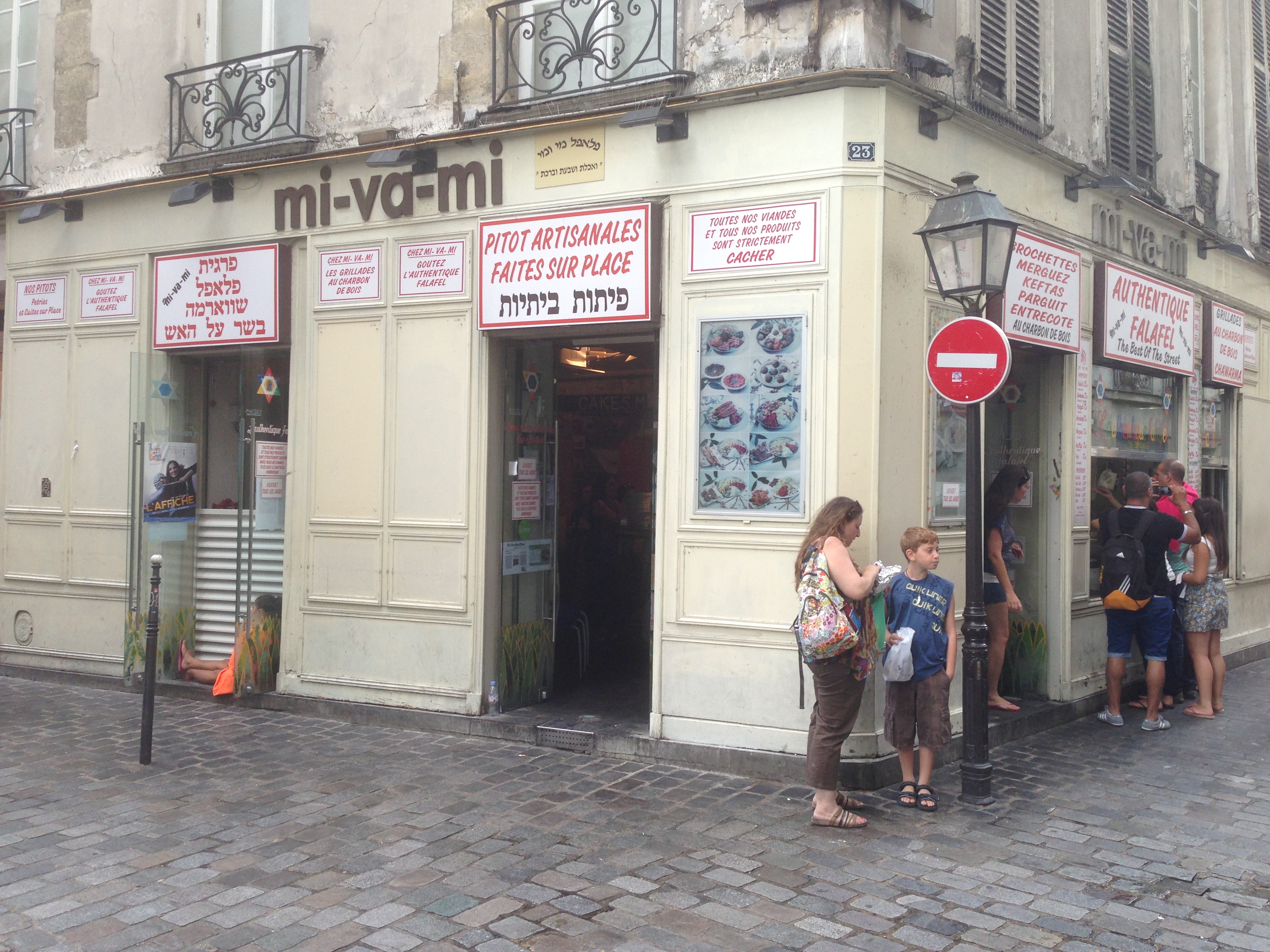
| | | | We enter the eastern end of Rue des Rosiers (ro.ZYÉ) and note two things. This is a short extension of the original street, and is therefore somewhat straighter. In addition, it's rather upscale, with boutiques, cafés, and restaurants on it. I've read that gentrification has hit this area, but hopefully it's limited at this end of Rosiers. A rosier is a rosebush, so this is Rosebush Street. It's had this name since 1230, which is typical for the age of all the medieval streets nearby. It was apparently named for the rosebushes growing at the time in neighboring gardens. | | | | After Rosiers, we'll be turning left on Rue des Écouffes, but we'll be passing two streets before that on which post-trip research has revealed some interesting information. We first cross (see map) the short and very practically-named Rue Pavée (Paved Street). I now find that a half-block to the south, at #10 on the east side, is the Synagogue de la Rue Pavée (Photo by Djampa) whose upper façade we see here. Click to see at the top the Tables de la Loi (Tables of the Law, or as they are widely known in English, the Tablets of Stone) with the Ten Commandments. But of particular interest is that the building was designed in 1913 by the Parisian master of Art Nouveau, Hector Guimard (Photo by Greudin), whose Métro exits are particularly famous. Even his signature here on the building reflects that style. The façade is made of gray concrete, and is typically undulating, and its lines are very vertical. The interior also reflects the Art Nouveau style (Photo by GFreihalter). In 1941, the building was dynamited by antisemitic collaborators of the Nazi occupiers, but was later restored. | | | | The next street on the left is the Rue Ferdinand-Duval (not named on map). Its history is what's most interesting. Up to the 15C it was once part of Rosiers, which had been L-shaped. When the L was straightened out, this street became detached, and Rosiers was extended straight to the east. From the 15C to the 20C it was called Rue des Juifs (Street of the Jews) because of the Jewish community. On a 1550 map it was also shown as Rue des Païens (Street of the Pagans). It wasn't until 1900 that it received its present name, that of a politician. The petition for change came in 1898 from merchants on the street, and the basis for the change is interesting—it was the result of the Dreyfus Affair (see 2011/14, Ctrl-F: Dreyfus Affair). And times continue to move on. This shop selling religious articles (Photo by djampa) is the last Jewish shop on the former Street of the Jews. | | | | On the north side of Rosiers, facing Ferdinand-Duval, is a Jewish bakery (click), the Boulangerie-Pâtisserie Murciano (Photo by Tim Sackton). We can use it to make a language comment. A boulangerie is a bread shop. A pâtisserie is a pastry shop. French doesn't have an umbrella word like "bakery" to cover both, so a shop selling both has to use both words in its name. | | | | The next street to the left is the Rue des Écouffes, part of our planned route, and there are a number of shops of interest right at this intersection. This view looks back east (Photo by ninara), where we just came from, with Rue des Écouffes to the right, beyond the lamppost. Click to inspect the bright green and yellow shop on the north side of the T-intersection. Although as is "ace", I'd say the As du Fallafel would be the Felafel King. The usual French spelling for the fried chickpea balls is falafel. | | | | But on the picture, also note the memorial plaque next to the green door's house number at #34, indicating that the past continues to live with us. Clicking, I can only make out the first two lines, indicating that "Here lived Louis Chapiro . . . ", using the French spelling for Shapiro. We've seen school memorials, but this is a house memorial about someone who lived there. The best house plaque I could find online is this one (Photo by GFreihalter): "Here lived Yvette Feuillet, FFI Sergeant, Awarded the Order of the Résistance, Killed by the Nazis in Auschwitz at the Age of 22 Years." The FFI were the Forces françaises de l'intérieur (French Homeland Forces) which were the result of the fusion in 1944 of the principal Résistance groups in France. I understand that there are some 25,000 house plaques like this in the Marais. | | | | Still at that very same T-intersection, facing the Felafel King, there are restaurants on each corner that are also delis and bakeries. On the southwest corner is the oddly-named mi-va-mi (Photo by RG72), which has some interesting signs from which we can get a wealth of word study. Click to start on the right, where we see this place is giving the King a run for his money by stating it has Falafel authentique, not only spelling the word in the standard form, but also putting it in English word order, followed by an English phrase, to try to catch the international crowd. | | | | Turning the corner is the sign saying that all their meats and products are strictement cacher (ka.SHÉR, rhymes with "share"). That would be "strictly kosher" in English, but the spelling in French wavers as to how to transliterate the Hebrew word כשר. The only thing consistent in the several transliterations is the vowel A (in contrast to the O in English and others). In French the word can start with a K or C, the middle can be English SH or French CH, and even German SCH has been proposed. The end can be the unusual spelling ER, or the more common ÈRE. Some of the numerous combinations of these are: kasher, kacher, cachère, casher, cacher, with proposals for kascher and cascher. Some suggest avoiding cacher as used in the sign, since it uses the same spelling as the verb "to hide" cacher, which, however, is pronounced ka.SHÉ. | | | | On the left, there are two more signs with a dig at the King across the street saying "At mi-va-mi taste authentic falafel", but more interesting is the use of the word pitot, which I didn't recognize or find translated online. Then came the revelation. I don't know Hebrew, but it seems to me that the ending –OT is a plural (I looked it up, and –OT is the feminine plural, while –IM is the masculine plural). So work backward, and pitot is the plural of "pita"! However, some sign painter seems confused, since further on the left appears the plural pitots. In any case, the larger sign on the right says PITOT ARTISANALES FAITES SUR PLACE (Artisanal pitas made on the spot), using the Hebrew plural in pitot with the French plural on artisanales. Final confirmation comes from the sign on the left: Nos pitots pétries et cuites sur place (Our pitas kneaded and cooked on the spot). | | | | | | The origin of the word "pita" remains unclear, but researching it resulted in a big surprise. The hypothesis that appeals to me is that the source could have been Ancient Greek πικτή "pikte" ("fermented pastry"), which developed into Modern Greek πίτα "pita".
But the Ancient Greek word seems to have also passed into Classical Latin as "picta", which appeared in Late Latin as "pitta" and developed into Italian "pizza" (PITsA)!!! What a revelation to realize that both PITA and PITsA could have the same origin and also be related as foods. After all, what's a pizza crust but a large pita. A pizza crust has items placed flat on it, while a smaller pita could either be filled or used to encircle gyro meat to make a sandwich. And is a stuffed-crust pizza imitating a pita?
|
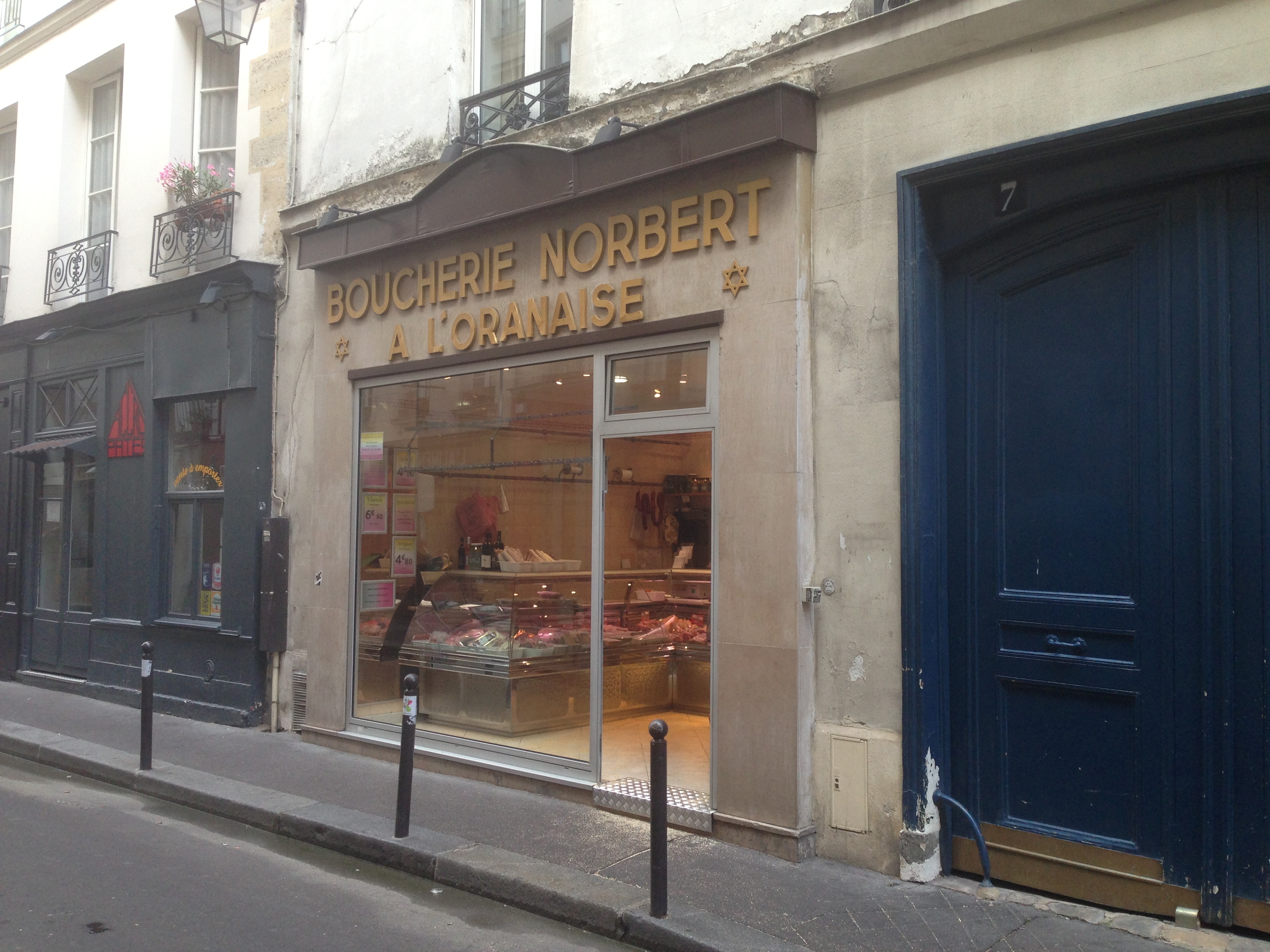
| | | | On the southeast corner is another bakery-deli-restaurant (Photo by Guillaume Speurt), which again uses both French words for "bakery", but adds traiteur, which, as we learned, means "caterer". But this picture shows a busy day, while we're here on the Saturday sabbath, and find a lot less activity (Photo by RG72), though it was open for business. But I was pleased to find the windows offered a field day of language study. | | | | The center window says they're Votre traiteur de la gastronomie yiddish (Your Caterer for Jewish Gastronomy)--using yiddish again as an adjective--specializing in Central Europe and Russia. The left window says they have two more things that in Yiddish in German are the same, Gehackte Hering (chopped herring) and Gehackte Leber (chopped liver), plus Gefilte fish, the same as in English. You may recognize other foods, such as latkes (potato pancakes). Bagels exist in France, and in that spelling, so I'd thought I'd found a spelling error in the right window where it says "N.Y. Beigels" until I realized with a smile that they were spelling it à la française to make sure people knew how to pronounce it. | | | | Very interesting about Rue des Écouffes, the street at the bottom of the T, was the derivation of its name. Like others, it was built up at the beginning of the 13C and already had an early version of its name by 1233. The street name might possibly refer to a sign that once represented a bird of prey, such as an eagle, falcon, or vulture; and that an archaic word for "bird of prey" was escofle, which developed into écouffe. It's further believed that that word was also slang for a pawnbroker, in the sense that you're calling a pawnbroker a vulture. I'm sure no one strolling on the street today sees the humor, but the name apparently means, very, very freely translated, both Street of the Vultures and Street of the Pawnbrokers. | | | | On Écouffes we find a Jewish butcher shop, a boucherie (Photo by RG72), and we also come across the facility operated by the Roger Fleischman Foundation (Photo by djampa). On the right is the synagog, and on the left is the oratoire, a sort of chapel that is also a school for religious instruction for Yiddish-speaking children. It was opened in 1931 by Armand Fleischmann in memory of his son Roger, a student of medicine who died at the age of 19. The school functioned normally for hardly a dozen years, at which point a great number of the students were deported. After the war, the school reopened for several years more. A few doors away was the building where 44 people, adults and children, were arrested in a raid on 16 July 1942 and deported. It was said that tous les étages retentissaient des pleurs des enfants (every floor reverberated with the sound of crying children). | | | | Before we leave the Jewish quarter of the Marais, find on our map Rue Sainte-Croix-de-la-Bretonnerie, just west of Rosiers. Since the 1980s, that's been the center of Paris's largest gay community, which helped reinvigorate the area. I found this picture of a pedestrian crosswalk in the Marais extended by the colors of the drapeau arc-en-ciel, or rainbow flag (Photo by Exilexi), and there is an annual marche des fiertés (pride parade) downtown. But with real estate prices rising, there's a curious conflict. The gay area is invading the Jewish area, but clothing boutiques are overtaking both of them. The gay area is said to be slowly turning into a boutique shopping center. | | | | Place des Vosges We have one last stop in the Marais. From Écouffes, we pass Roi de Sicile to get to Rue de Rivoli, and cross Place Saint Paul one last time to proceed down Rue Saint-Antoine toward the Place des Vosges. But first we should see how this area developed. On the historic map you'll see in this area the former palace called the Hôtel des Tournelles (listed as Les Tournelles). It was an ensemble of buildings built, starting in the 14C, to the north of the present Place des Vosges. It was long the property of the kings of France, though few lived there. Catherine de Medici neglected it as being out of fashion, transformed it into a powder magazine, then sold it to finance building a palace in the Italian stile, the Tuileries. Nothing is left of it. The name is based on tour "tower", as tournelle is a form of a diminutive of it. | | | | | | It struck me from reading this that "tower + -ette" might be the origin of "turret". The Online Etymology Dictionary says that Old French torete, based on just that sort of word structure, entered English c1300 in the form "touret", which became "turret". But it also says that that Old French word entered Modern French as tourette as well. Then Google Translate tells me that "turret" in French is tourelle (presumably a synonym), without that –N-, which must be an antiquated form. In any case, the Hôtel des Tournelles had a large number of turrets/little towers, according to the style of the day, hence the name. |
| | | | Once we turn off Rue Saint-Antoine, we're delighted to find that we can use as a shortcut the early-17C Hôtel de Sully, one of the most fashionable mansions in the Marais. The Sully is a Renaissance palace, built between 1625 and 1638. It's now a public building, but still it's a little odd that we can cut through it to reach the Place des Vosges. This is a plan of the Hôtel de Sully (Sketch by Paris 16) showing the route from the Rue Saint-Antoine via its Court of Honor, then its garden, to the Place des Vosges. This drawing shows it even better:
https://medias.monuments-nationaux.fr/var/cmn_inter/storage/images/hotel-de-sully/preparer-sa-visite/plan-du-monument/1788341-1-fre-FR/Plan-of-the-monument_image-max.png
| | | | We first see the façade facing Rue Saint-Antoine—click to admire the fine detail. We enter through that doorway and come out of the doorway in the south façade of the courtyard (Both Photos by Mbzt)—click again. We leave the courtyard on its north side, and exit into the garden via the garden's south façade (Photo by Beckstet). Turning north again in the garden, we see the orangerie (Photo by jean-louis Zimmermann). That doorway on the far right leads directly into the arcades of the Place des Vosges.
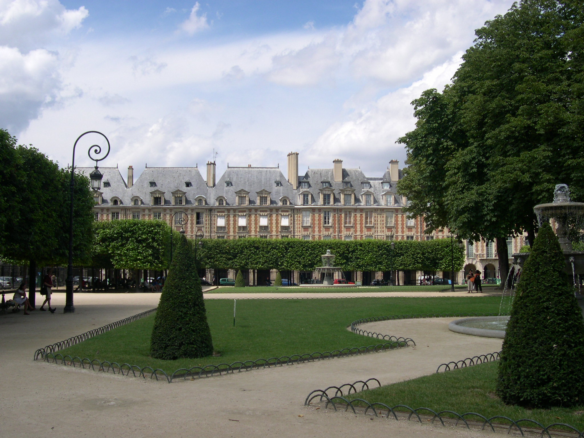
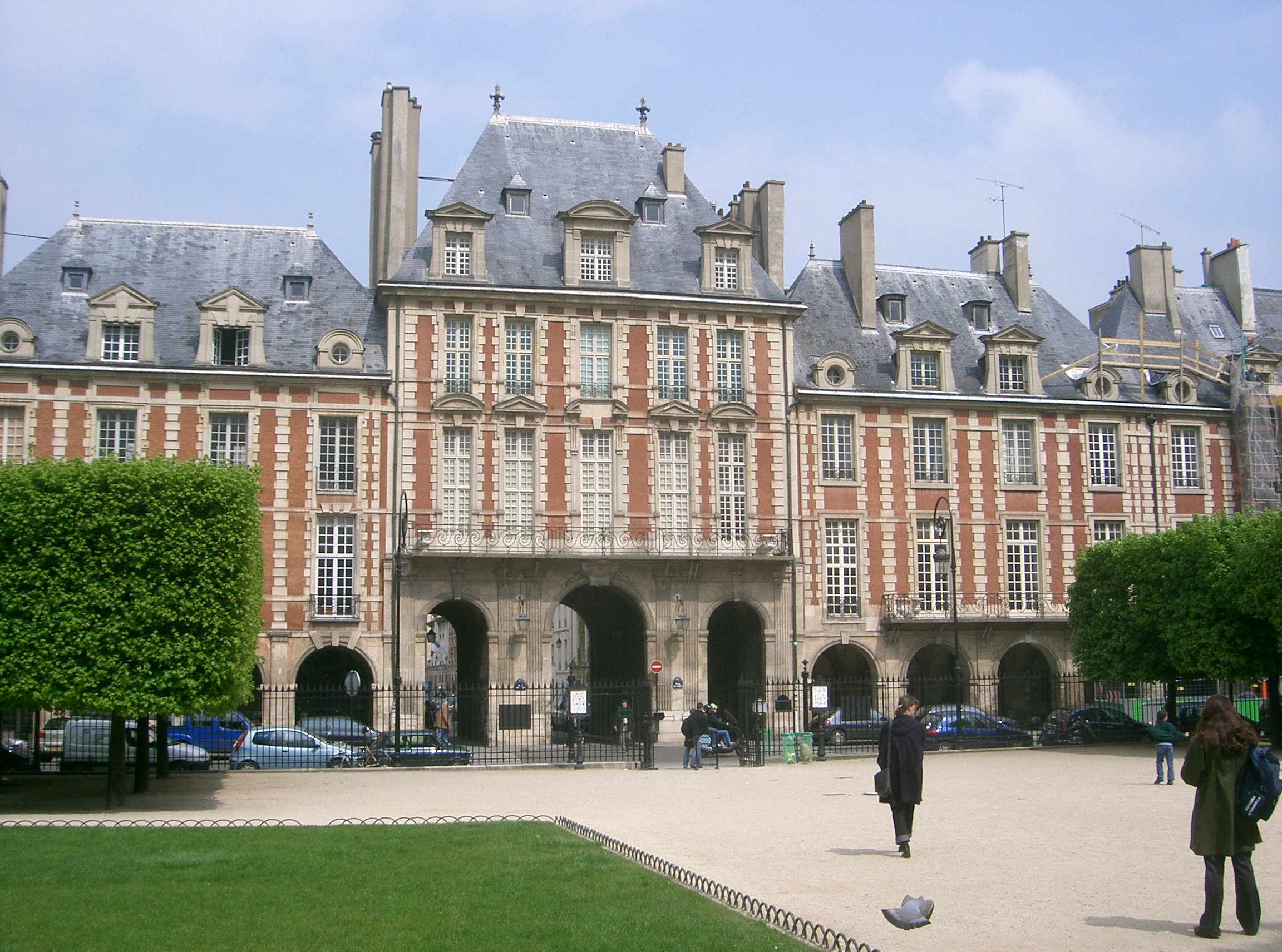
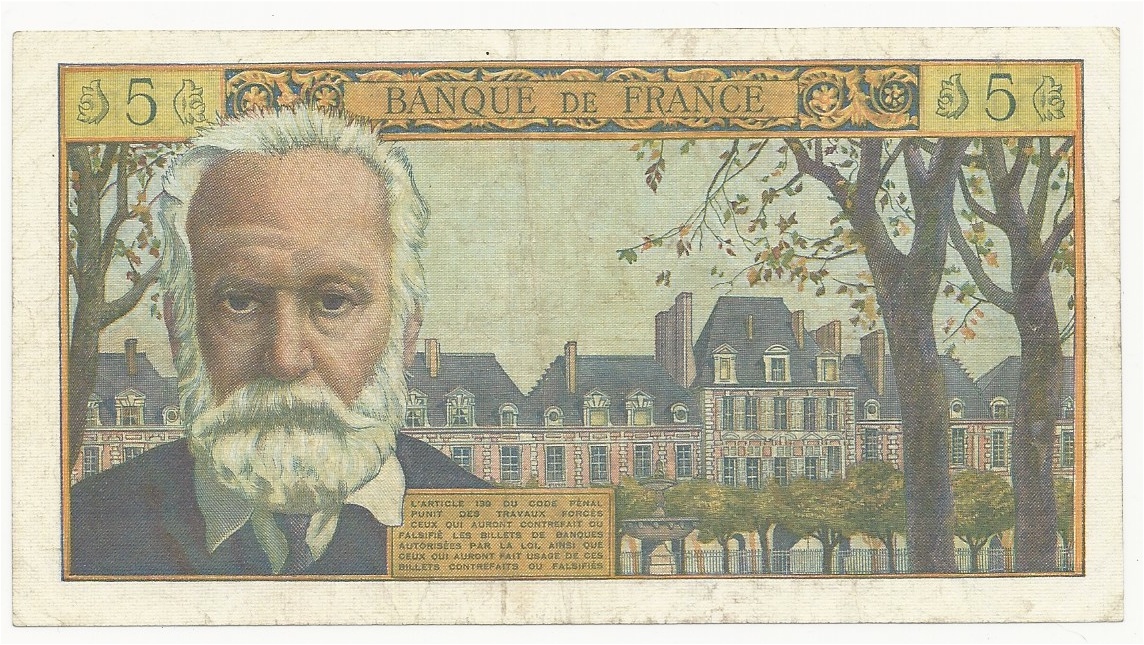
| | | | Paris is rife with public squares, as are many European cities, because the web-like, non-grid layout of streets is conducive to it. The most intimate are the human-sized ones, laid out by people walking, such as Place de la Contrescarpe on the Rue Mouffetard and Place du Tertre in Montmartre. In contrast are the big splashy ones built by the authorities, such as Étoile, Concorde, and the others. But while these may have their glitz, I don't think they can hold a candle to the two "V-Squares" in Paris, the Place des Vosges that we'll visit now, and the Place Vendôme that we'll see tomorrow. Both of these, but particularly Vosges, are much more residential than many others and exude a very special quiet charm. | | | | The Place des Vosges (VOZH, rhymes with "loge") is the oldest square in Paris--construction began in 1605. Until 1800 it was known as the Place Royale. It's not named after the Vosges Mountains directly, but is named after the Département des Vosges, which is near Germany and part of the former Lorraine. It's the département then that's located in the Vosges mountains and is named after them. | | | | The Place des Vosges has been the primary monumental square of Paris used for official ceremonies, such as for the wedding of Louis XIV. Its residential nature is reflected in its many famous residents, perhaps most notably Victor Hugo (see below), but also Alphonse Daudet, Colette, Georges Simenon (Maigret), and Isadora Duncan. | | | | It's a square square, if you know what I mean, not a round or free-form city square (Map by OpenStreetMap contributors). That it's a quiet residential area is indicated by the few vehicular access points—north, south, and the two upper corners. They can of course also be used by pedestrians, but you also see in the southwest corner the pedestrian access we found by luck through the Hôtel de Sully. You can also see the park filling the center, which brings up that quirk of French we discussed earlier. The park is called the Square Louis XIII, and is located in the Place des Vosges, that is, a square located in a place. You can't do that in English. The best you can say is it's a park located in a square. | | | | Let's now step from the Sully garden into Vosges. We enter via an arcade (in the southwest), because all four sides of Vosges are arcaded. These are arcades on the east side (Photo by Mbzt) and these are arcades on the north side (Photo by Gryffindor). Click to see architectural detail on both. | | | | This is a slightly distorted, wide-angle shot of Square Louis XIII in the center of the Place des Vosges in the autumn (Photo by Mbzt), giving a sense of the uniformity of the architecture of the Renaissance ensemble surrounding it. This view shows a fountain in the center --the cutesy sign says "Lawn at rest"--while this one shows a view of the western side, with topiary (Both Photos by AlNo). Notice the arcades in both views. Finally, this is the Pavillon de la Reine (Queen's Pavilion) on the north side, which includes vehicular access (Photo by Beckstet). There's a corresponding Pavillon du Roi (King's Pavilion) on the south side, with vehicular access. | | | | Look at our main Marais map again, and you'll see that Victor Hugo's house is located on the southeast corner of the square, somewhat parallel to the Hôtel de Sully. He's particularly associated with the Place des Vosges, as can be seen on the back of this old, pre-Euro 1959 five-franc banknote honoring him, but showing the Place des Vosges as well (Photo by Berlin-George). | | | | The Bastille Then As we leave the Place des Vosges down the Rue Saint-Antoine, headed for the Place de la Bastille (see modern map), everything in sight is screaming the name of something that no longer exists. Let's take one last look of our historical map to see that the Bastille would have blocked our way, because it was a bastion protecting the city gate, the Porte Saint-Antoine, and the nearby royal area, although in this case, it's the new (Nouvelle) gate, in the newer wall, the older one in the old wall having been back at the Métro station in the Place Saint-Paul. | | | | Back in the day, this would have been a bird's-eye view of where we are. It's a detail from a 1739 map of this area, looking southeast. Start at the Place des Vosges at the bottom, and click. It's still called here the Place Royale, using the old spelling, Roiale. A statue of the king is in the center. The Rue Roiale leads out from the Pavillon du Roi to the Rue Saint-Antoine. We see what is probably the original version of the church that Saint-Paul's took over. But then the Bastille, pointing outward, blocks one's passage, or at least overlooks those passing through the Porte Saint-Antoine. We also have this even earlier view, from 1656,, looking east down the rue Saint-Antoine to the Bastille (spelled here with the long S). Once you'd walked through the gate and looked back, you'd see this view from the northeast, showing the use of the gate (1715-1719). | | | | How did Saint Anthony get so involved here? We have Rue Saint-Antoine, the Porte Saint-Antoine, the Bastille de Saint-Antoine, and more. It has to do with suburbs around Paris. When we went down to the Marne, we were in a couple of modern suburbs, but here we're dealing with a very old suburb, now part of Paris. This brings us to a short word study on suburbs. | | | | | | English steals two roots from Latin so that "sub+urb" is literally "under-city". That imagery would go back to when a city, with its castle and wall, might have been on higher ground so that the unprotected areas around it were lower, hence "under-city". German uses Vorstadt, literally "pre-city", which is pretty cut-and-dry. But French uses two words, in slightly different senses. One is faubourg (fo.BUR, rhymes with "tour"), which takes an antiquated word for city, bourg, Germanic in origin, which also appears in "bourgeois", "burgher", and even "borough", and prefixes to it our old friend, faux, "fake", with a silent X. It then drops the silent X, which is useless anyway, and spells the combination faubourg, literally "fake city". I think that deserves at least a smile.
But over time, as cities have expanded, faubourg has come to indicate former suburbs, long since absorbed into the city proper. The word for what we'd consider an actual suburb today is banlieue, but this has an equally ancient origin. It's based on the Germanic word ban which was the legal right of feudal lords to dispense justice, defend the defenseless, and also to conscript into armies. Tax collection was also involved. This right, the ban, applied to those living within one league, or 4 km (2.5 mi), of a city. The French word for "league" is lieue, and so a banlieue, literally—and very roughly--the "jurisdictional limit" around a city, now simply refers to a contemporary suburb.
|
| | | | Using the name of a saint, it has to go back to a church or abbey, right? Well in this case, it was the Abbaye Saint-Antoine that lay to the east of the Marais (its full name added "des Champs" or "in the Fields", the sort of naming practice we've seen before). It was destroyed in the 18C--which again sounds like the French Revolution at work to me--but nevertheless, the Faubourg-Saint-Antoine (Map by Mbzt) had already developed around it, as seen here in 1760. This suburb explains the name of the Rue that led to it, the Porte that did the same, and the Bastille, that protected them both. Click to find the abbey and all the streets leading to the gate. But even better, find the main street of the suburb, which is of course the Rue du Faubourg Saint-Antoine! Not only does it still exist, but it's a main route connecting the Place de la Bastille with the Place de la Nation. | | | | The "Bastille" Now As for the Bastille now, there isn't one, once it was torn down during the Revolution in 1789 on the aptly named French national holiday, Bastille Day, 14 July. In its place is the nondescript Place de la Bastille, a big wide-open area with little interest for me. It's true that the Bastille had become a prison, but at the time it was town down, it housed only three prisoners, so destroying it was much more symbolic than practical. Look at how large and rambling it appears on the Marais map, especially when compared to the orderly Place des Vosges we just visited.
http://atlantislsc.com/wp-content/uploads/2017/12/map-marais-paris-download-marais-map-paris.gif
| | | | We'll call this the [Place de la] Bastille map and flip between it and the Marais map if needed. Following is more or less the view you get of the Place de la Bastille when leaving the Marais (Photo by Mbzt). The Colonne de Juillet that we saw from the canal boat is nice, but I'm sure its purpose goes over the heads of most visitors, even the French, who confuse it with something that might be representing the 1789 Revolution. On the right is the Opéra de la Bastille. I do not enthuse about its architecture. Otherwise the Place is a patchwork quilt of buildings that don't necessarily harmonize, located around a traffic hub. The cafés are nice. | | | | It IS unique that the Canal Saint-Martin flows under the Place. We walk to the south side overlooking the Bassin de l'Arsenal for the views. We walk to the north side to see the Boulevard Richard-Lenoir, but don't hike far enough to see the parks covering the canal tunnel, which are up some distance. But if you like the history of the place, you won't be disappointed. This is a plaque showing the Bastille superimposed on the Place (Photo by Mbzt). It reads in translation: Plan of the Bastille, Begun in 1370, Taken by the People on 14 July 1789 and Demolished the same year. The Perimeter of the Fortress is traced on the Ground of this Square, 14 July 1880. And so it is. You can walk around following the layout to your heart's content.
http://lescockersdemaryse.l.e.pic.centerblog.net/bastille-vestige.jpg
| | | | But actually, it gets even better. You'll recall that there are three Métro lines under the Place. Line 1, as we saw, is open-air above the Arsenal Basin. But the other two have stations (all three are connected) right under the Place, and each of these two lines shows, right on its subway platforms, the architectural finds that were discovered there.
http://p0.storage.canalblog.com/01/90/214415/60202106.jpg
| | | | Line 8 (above) boasts of its vestiges of the counterscarp of the Bastille. Line 5 speaks more generally of its vestiges of the Bastille, then traces along the platform floor the further extension of the wall (Both Photos by Clicsouris). | | | | Promenade Plantée On an earlier trip to Paris, possibly the one in 2005, I remember being in the Place de la Bastille one day when it was beastly hot. Yet I felt I had to experience a bit of the Promenade Plantée ("Planted Promenade"), so I found it, climbed up to the viaduct, and had enough energy to walk maybe a block, no further, because of the heat. Therefore I didn't see much of it, but was at least able to say I experienced some of it, however little. | | | | That was to be rectified this year. I'd walked the first third of New York's High Line after it opened in 2009 (in red), and last year walked the full length of its viaduct (2017/8) from Gansevoort Street to 34th Street (Map by Mj). And with the 1988 Promenade Plantée being the model for the High Line and others, I wanted to walk it, too. The major point, though, is this. While there may be other disused rail lines converted into parks or trails—the term "rails-to-trails" is used to describe them—the Promenade Plantée was the first promenade built on top of a viaduct, and that remains its chief distinction. | | | | The High Line is on a viaduct end-to-end, but the older Promenade Plantée can't boast that distinction, which is ironic, since it's the viaduct that makes it unique. Only its first section is on a viaduct, but once it crosses the Jardin de Reuilly, it becomes a linear park up to roughly the city line, indistinct from any other rails-to-trails route. When I was planning doing this, I had two thoughts in mind. Follow on this map from "parisinspired":
https://parisinspired.files.wordpress.com/2013/06/used-2013-05-16-paris-inspired-paris-paul-prescott-coulc3a9e-verte-promenade-plantc3a9e-map.jpg
| | | | One plan was to attempt the entire route, as friends Paul and Marya had recently done, with them picking up a picnic lunch en route to enjoy in a park at the far end. If I did that, I'd be able to get the 3a tramway at Montimpoivre. The other plan was to find "escape routes" on the way, such as via the Bel-Air station (click) to cut it off there, or even better, via the Montgallet station, just north of the Jardin de Reuilly, unnamed, but the large green space on the route. After the long walk in the Marais, the Montgallet option proved most attractive, and would have covered the whole viaduct area, which is what interested me most. This is another good drawing you might like to review:
http://static.messynessychic.com/wp-content/uploads/2012/07/promenade-plantee-map.jpg
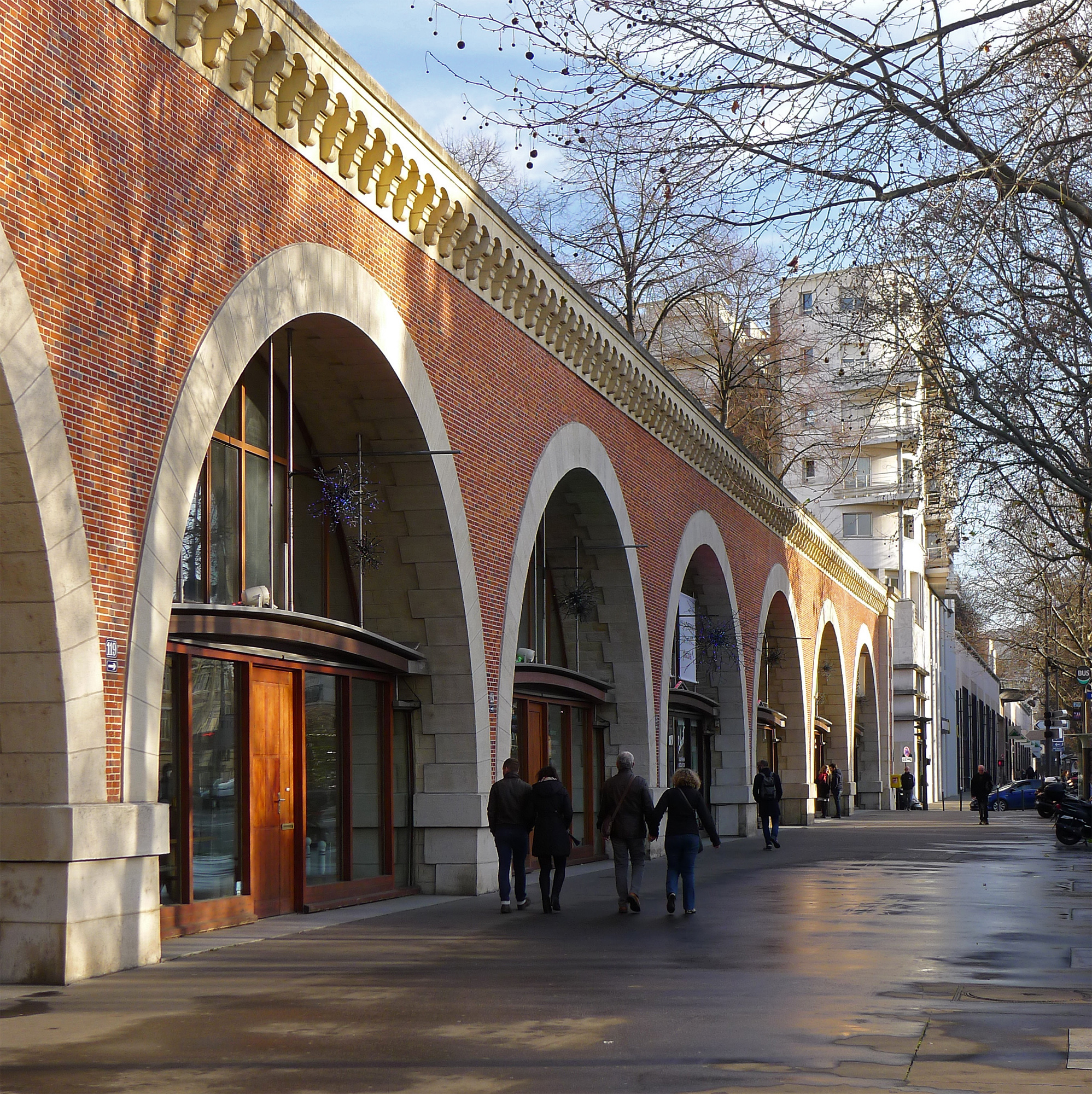
| | | | In 1859, the Compagnie du chemin de fer de Paris à Strasbourg (Paris-Strasbourg Railway Company) built the line that came to be known as the Ligne de Vincennes (Vincennes Line), since it left Paris in that direction. At its head, on the Place de la Bastille, was the Gare de la Bastille (Photo by ASTIER), as seen here in this southwest view, before its destruction in 1984. Steam trains were still using it, and the last one left in late 1969. It was the construction of RER line A crossing all of Paris that made the Ligne de Vincennes redundant. In place of the Gare de la Bastille, the Opéra de la Bastille opened in 1989 as a second opera house to the one on Place de l'Opéra. | | | | That left the viaduct that carried the former tracks leading into the station. The city of Paris acquired it in 1986, and as of 1994, the Promenade Plantée was opened on top of it from Bastille to Reuilly. Then the huge vaults under the restored viaduct were converted into craftsmen's workshops and galleries renamed the Viaduc des Arts. It houses cabinetmakers, musical-instrument makers, fashion designers, textile restorers, and other businesses related to the arts. | | | | | | One thing here irritates me, and so I'm going to ignore it. It seems there's been a passion for renaming familiar things for people, who, I'm sure, are very deserving, but the whole process is disruptive. We've had a spate of bridges, tunnels, and highways in and around NYC redone this way, which most people ignore. The name Promenade Plantée is well-known, descriptive of what it is, and nicely alliterated. But official changes have been made. The phrase coulée verte is a greenway, describing any rails-to-trails route, and more. Now the Promenade Plantée has officially been renamed the Couleé Verte René-Dumont, named after a French agronomist. But I question if people really have switched to that, any more than New Yorkers calling the Triborough Bridge the Robert F Kennedy Bridge. Anyway, for me it remains the Promenade Plantée. |
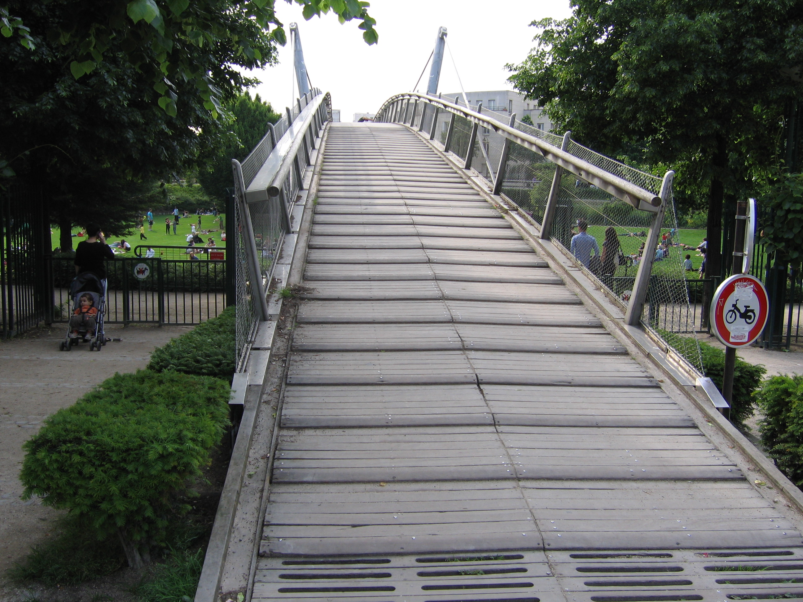
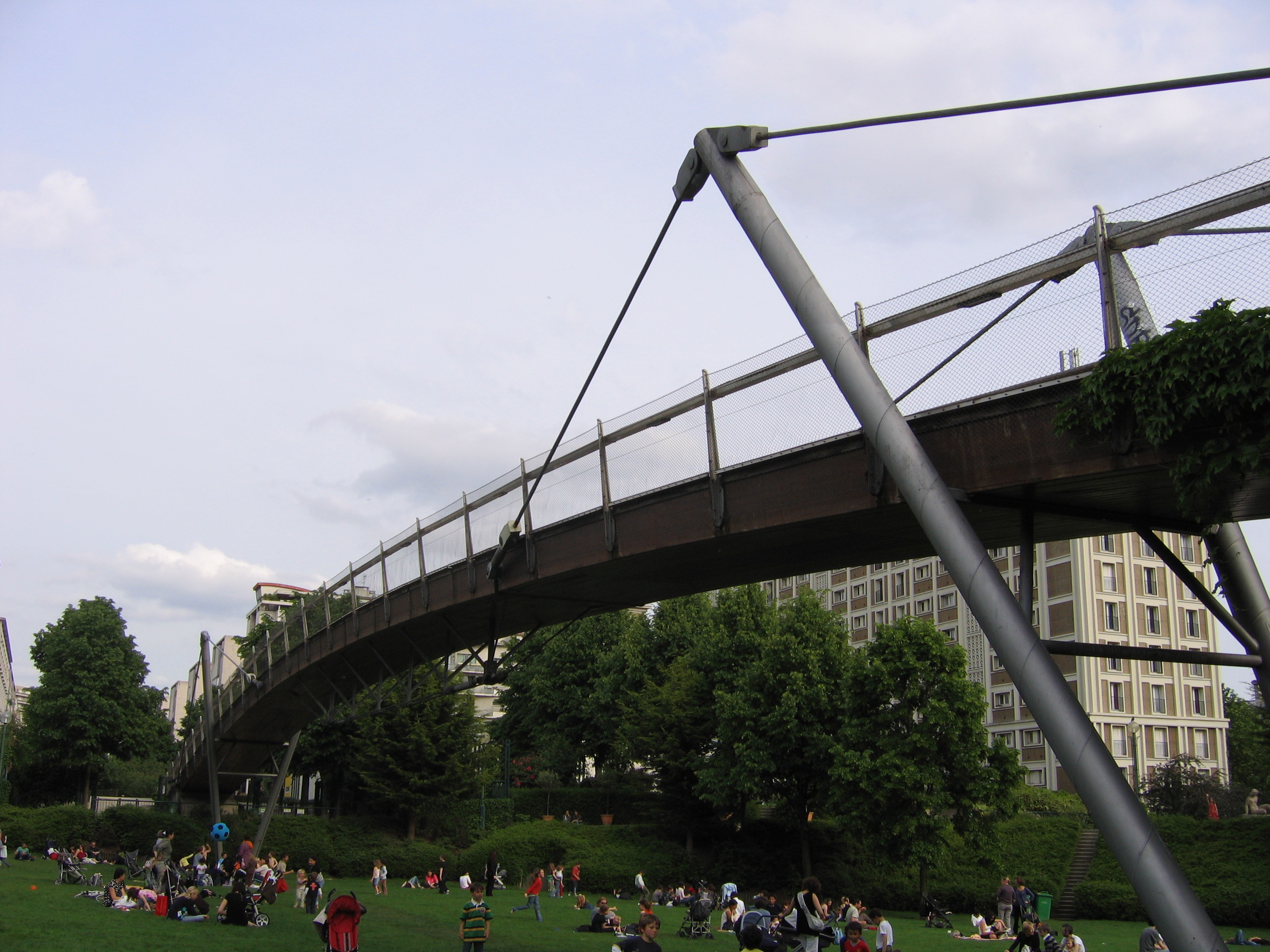
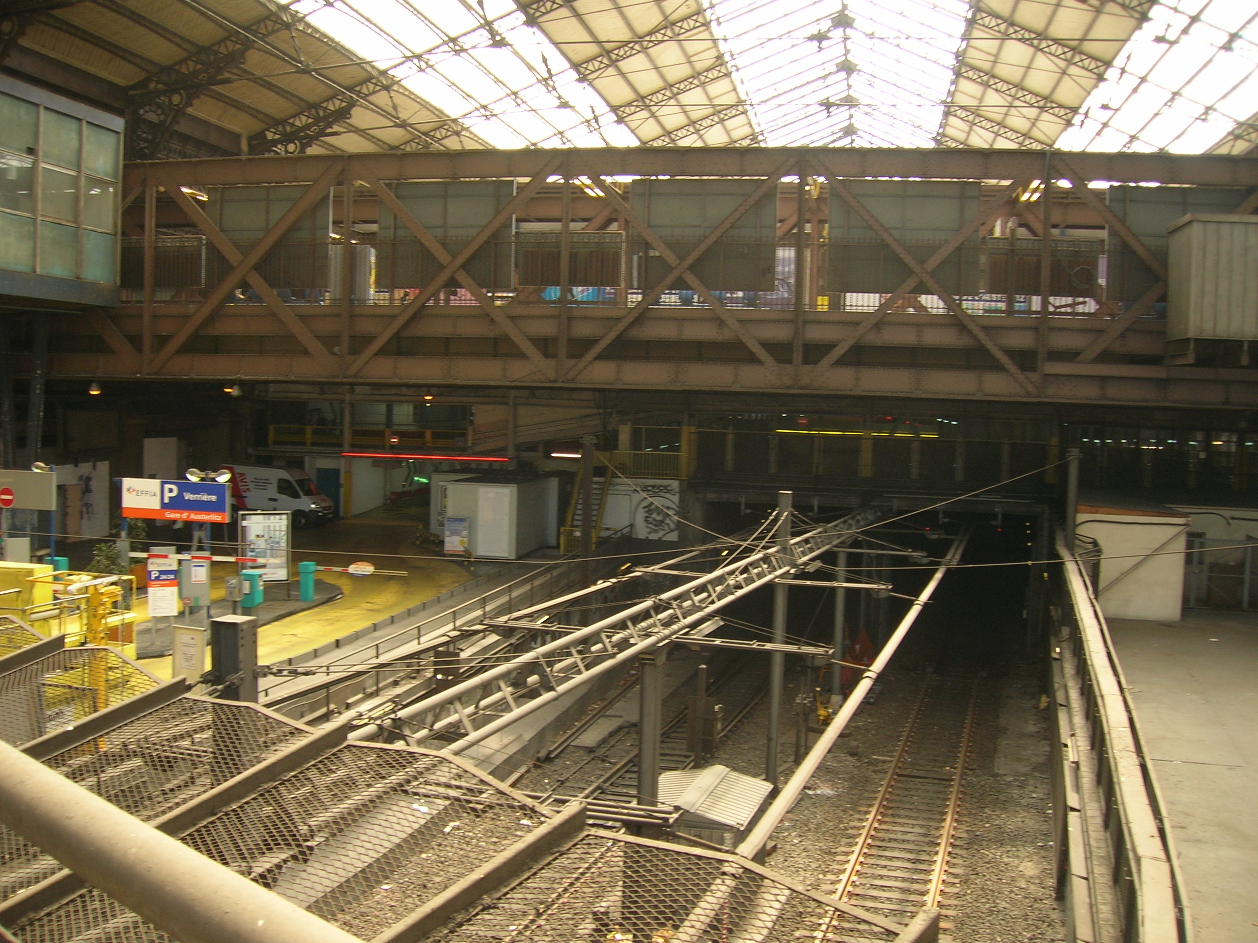
| | | | Walking the Promenade Plantée Viaduct The Bastille map will show just where the old Gare de la Bastille was—at the opera house—and how we have to swing down the street around it to find the actual viaduct. But before we climb the staircase up to it, we take a look around it so see the vaults of the craft shops in the Viaduc des Arts, unique to Paris (Photo by Mbzt). The pink bricks and cut stone frame the glassed-in arches nicely. At the top of the stairs, we find the entrance to the promenade, which is so very obviously plantée. The walkway has perhaps fewer flowers than you might expect, but is lushly green (Last two Photos by Wowo2008). Further down, we have an area with a trellis (Photo by Wowo2008). | | | | The greenery is nice enough, but what makes the walk stand out for me are the city views from up on the viaduct. Here we have a southwest view (follow on the "parisinspired" map) to the Gare de Lyon, still on this side of the river (Photo by David.Monniaux). Note the period apartment buildings and their style. I'm particularly enamored of views like the following one, looking down on a corner café through the shrubbery (Photo by Twice25). Toward the end comes a pleasant surprise, a long pond (Photo by Wowo2008), where the path splits to go around it. | | | | As we come to the end of the viaduct, there's still a bit more I find of interest, located in Reuilly (rö.YI). The Reuilly quarter/neighborhood isn't an official quartier of Paris. But it had been a hamlet, then a village, and was finally attached to Paris in 1702, the same time that its neighbor, the Faubourg Saint-Antoine, was. Further along on our route than we'll be going, the Gare de Reuilly was a station on the defunct rail line, and has been recycled for another use. But closer than the Gare, the former rail yard here has been made into a park, the Jardin de Reuilly (Reuilly Garden), which is now part of the Promenade Plantée, though beyond the end of the viaduct. How they meet, though, is unusual. As the viaduct ends near the Rue Montgallet, the route climbs over the Jardin de Reuilly on a passerelle (footbridge), then goes down again to street level on the other side. Check this out on the above drawing of the route, then follow these pictures. Here's the approach to the footbridge; then we have a darkish picture of the cable stays on the footbridge (Both Photos by ~Pyb), which allow it to jiggle a bit over the street-level park. Finally, a nice view of the bridge over the park's sunbathers (Photo by patrick janicek), again giving a view from above as we've been having all along. | | | | We go a bit beyond the park and find a bench to rest on after the Marais walk plus this one. We see on the drawing what I'd heard about, that the route goes through a dark tunnel, then continues as a mall-like linear park along Avenue Vivaldi (Photo by Mbzt). It's no longer on a viaduct, but runs on street level and in trenches, as the train had done, and was now open to cyclists. The upcoming area seems sterile to me and worth ending the walk here. We cut over to the Montgallet station on line 8. It turns out to be a quite modern, yet very tranquil neighborhood that I find really quite pleasing. | | | | Let's first look at some statistics. The High Line is 2.33 km (1.45 mi) long while the entire official length of the Promenade Plantée to the furthest point is 4.7 km (2.9 mi), meaning it's twice the length. But I checked on Google Maps, and the length of the viaduct plus footbridge as we've just walked them comes to 1.6 km (0.99 mi), which is 34% of the Promenade Plantée, roughly a third, and suited me just fine. We still have a couple of mini-adventures for this afternoon. | | | | Day 6 Sa9 (Second Part) Austerlitz, Métro Remnants There were two classic Métro experiences I wanted to have, and this was the time for them. For the first one, I went back on line 8 from Montgallet to Bastille and took line 5 round-trip to Saint-Marcel (see Métro map). The round-trip means I saw what I wanted to see twice, but it's better described on the return trip. | | | | Gare & Viaduc d'Austerlitz In the last posting regarding bridges in Paris, we said that ● two are rail bridges and ● two have both a vehicular level and a rail viaduct. One of each is in western Paris and one of each is in eastern Paris. . . . in the west, we've crossed (and walked under) the Pont Ruelle, the rail viaduct carrying RER C, and we've seen and walked under the Pont de Bir-Hakeim, dodging its vehicular traffic and seeing Métro line 6 crossing it. We said that in eastern Paris there's also ● a rail bridge and ● a bridge with both a vehicular level and a rail viaduct. [Yesterday we crossed] the Pont de Bercy, which has a rail viaduct for Métro line 6 over a vehicular roadway . . . [and today] we'll ride line 5 on its viaduct through (!!) the Gare d'Austerlitz and then cross the Viaduc d'Austerlitz, a rail viaduct over the Seine (not to be confused with the adjacent Pont d'Austerlitz, a road bridge). That's what we're in the process of doing right now, starting south of Austerlitz at the Saint-Marcel station on line 5. | | | | We're now at Saint-Marcel (Photo by Greenski). The train came from the viaduct down underground through the tunnel entrance (click) as we arrived here on the left platform, but we'll now change to the right platform to go back up from underground to cross through the Gare d'Austerlitz and over the Seine again. The train emerges back onto its viaduct at a grade of 4%, and continues just the one stop to Austerlitz (see Métro map; also remember that yesterday we crossed over the Austerlitz rail yards on line 6, but weren't at the station). | | | | Our train on its viaduct reaches the Gare from the west, its back side, and actually physically enters the station (Photo by Roehrensee). Inside, we—in our train on its viaduct--are under the station's glass roof and some 20 meters/yards above, and perpendicular to, Métro line 10 and RER C below. And thus we have the elevated Métro station Gare d'Austerlitz located physically inside the rail station Gare d'Austerlitz. This shows the inside of the elevated station (Both Photos by Vincent BABILOTTE). Unusual girders seem to be needed between the platforms for extra support. Click to see the view out to the Seine and to read the sign and confirm our direction is toward Bobigny. We also have below a floor plan of the Gare d'Austerlitz. The top, with the rail tracks, is south, so the Seine is on the left. On the upper right, under the orange work zone, you'll find "RER C". Near the viaduct there are stairs marked "M 5 10", going down to the 10 and up to the 5.
https://www.gares-sncf.com/sites/default/files/field_plan_files/2017-10/paz-site_internet_1.pdf
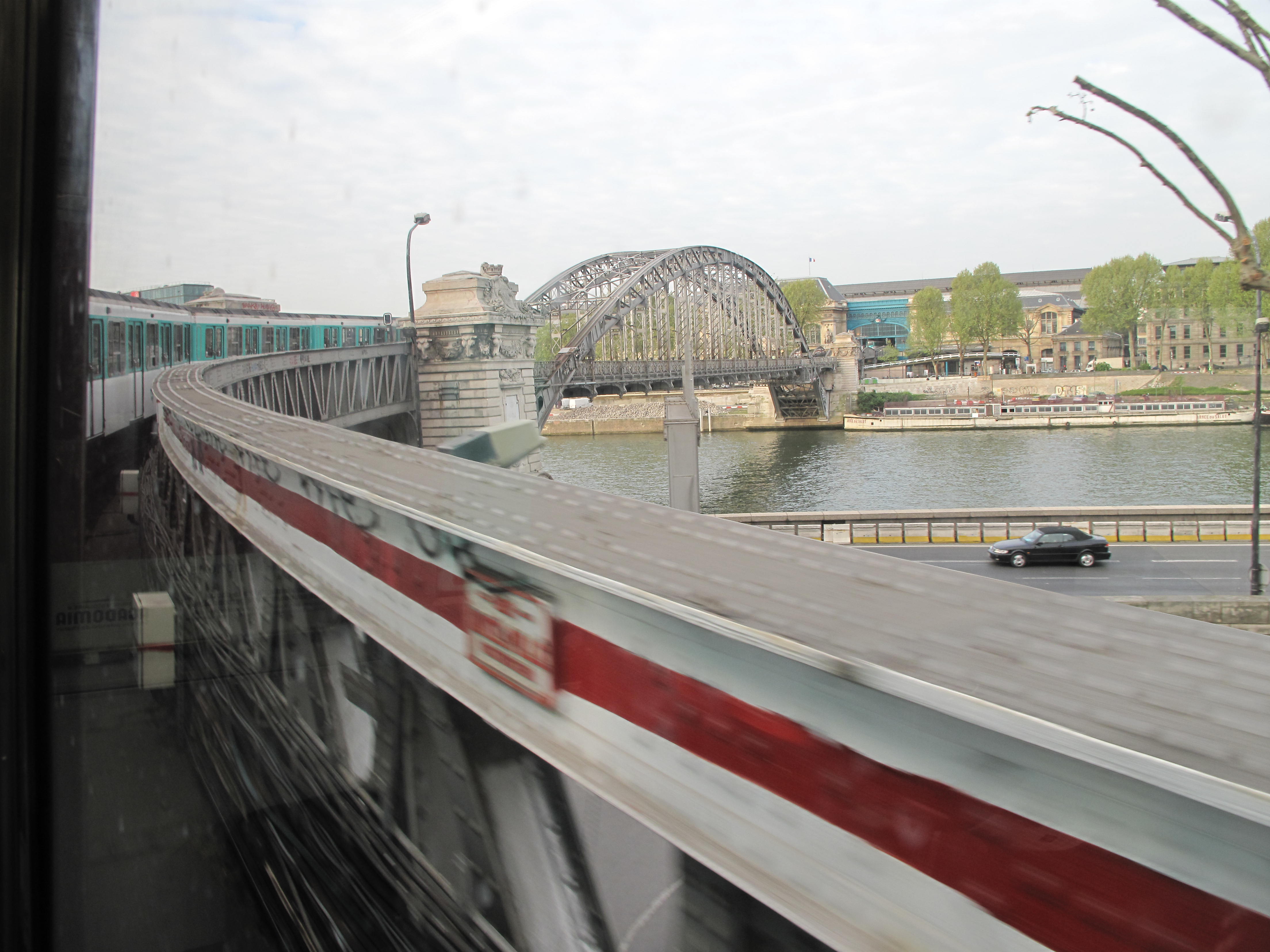
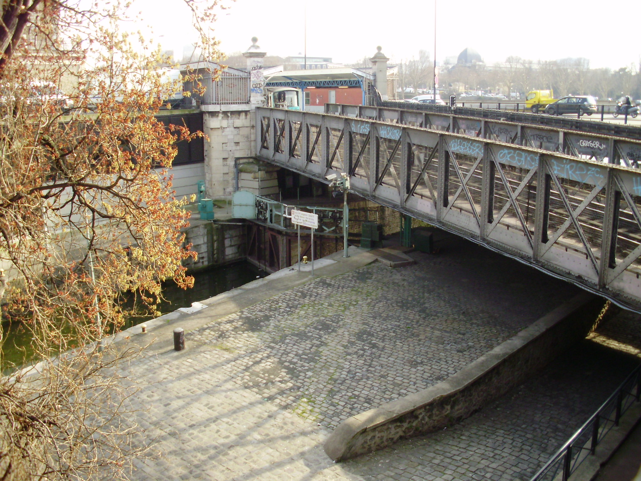
| | | | The viaduct then pierces the front (east) façade of the station to cross the Seine (Photo by Roehrensee), looking like an arrow shot into a tree. From here all the way over the Seine it's now called the Viaduc d'Austerlitz. This is the same view from below (Photo by Mbzt). | | | | A viaduct piercing a building is amazing to see, but seeing the actual span of the Viaduc d'Austerlitz (Photo by Mbzt) bounding over the Seine is spectacular, especially in connection with a train coming out of Austerlitz to make its crossing. When the Métro was being built, it was easier to build a bridge to cross the Seine than a tunnel, but it was implausible to place a pier in the middle of the river. So in 1903, a single-span steel bridge was built, with the span being 140 m (459 ft) long, a record for Parisian bridges at the time. The span is supported by two parabolic arches above, with everything resting on a stone pillar on each shore. The arches are joined at three locations, one on top of the arcs, and one on each shore. And here we see our own line 5 train crossing back to the Right Bank, where we started out. | | | | But now make note of the adjacent, lower bridge downstream. This is the Pont d'Austerlitz for road traffic, not to be confused with our Viaduc d'Austerlitz for rail. Now here's a cute trick. The train you see will go around the curve at the right and end up parallel to the river along the Quai de la Rapée. This is that curve, but looking back toward Austerlitz (Photo by Tangopaso). Click on the blue area to see Austerlitz with a train coming toward us, in our direction, while the closer train goes back. | | | | The name of the viaduct now changes to the Viaduc du Quai de la Rapée, and it will immediately plunge underground on a 4% grade to go UNDER the vehicular approach to the Pont d'Austerlitz then rise again UP onto a viaduct again to serve the Quai de la Rapée Métro station. Follow these maneuvers on the Métro map, although we're not done yet. | | | | We saw the following three pictures two days ago on Day 4 when we entered the Canal Saint-Martin under the Métro line, so now we're doing the reverse, going over the entrance. This shows the Quai de la Rapée Métro station (Photo by David Monniaux) well above ground on its viaduct (click), from which trains will cross over the entrance to the Canal. Again we see this view of our train doing just that, going over the gate to the lock (Photo by Geralix). And here is another view of our line 5 train crossing over that gate, seen from the neighboring road bridge (Photo by Tangopaso). | | | | Since cutting through the Gare d'Austerlitz, we've been above the Seine, then below ground, then above the Canal, and so we now plunge underground a second time to run along the west side of the Bassin de l'Arsenal to Place de la Bastille. Do check this again on the Métro map to make sure you understand our roller-coaster adventure. | | | | Métro Remnants If you're tailoring a suit, or carpentering a shelf, or making a pie crust, there are always bits and pieces left over. Not wanting to be wasteful, you'd like to find a way to use or recycle them. We have a similar situation with the Paris Métro, and with other subway systems, including NYC's.
| | | | In addition, in 2018/6 we talked about the loss, then rebirth, of the Cluny Station, and the loss of the Croix-Rouge Station. Among our leftover Métro bits and pieces we'll find another ghost station, which was never even opened up in the first place. | | | | So the second of our two Métro trips, after Austerlitz, will be to check out these two remnants, line 3bis and line 7bis, and our additional station fantôme (ghost station), with the intriguing name of Haxo. (It was named after Rue Haxo (ak.SO) above it, which in turn was named after a general, François Nicolas Benoît Haxo.) | | | | | | But first let's make sure we're all on the same page with the terminology. French uses bis (rhymes with "beas[t]" without the T) in the meaning of "a second one, another one". So calling it line 3bis is like calling it line 3a. This is also used with house numbers when a newly inserted house number is needed, such as in the series 11, 11bis, 12. If you eat a French biscuit or an Italian biscotto you may recognize from earlier discussions that they both mean "twice-baked". I'm quite sure bis is related to "bi-"; if something takes place every second year, it's "biennial" in English, but bisannuel in French. So, in our present context, you should expect to find line 3bis near line 3, and 7bis near line 7. |
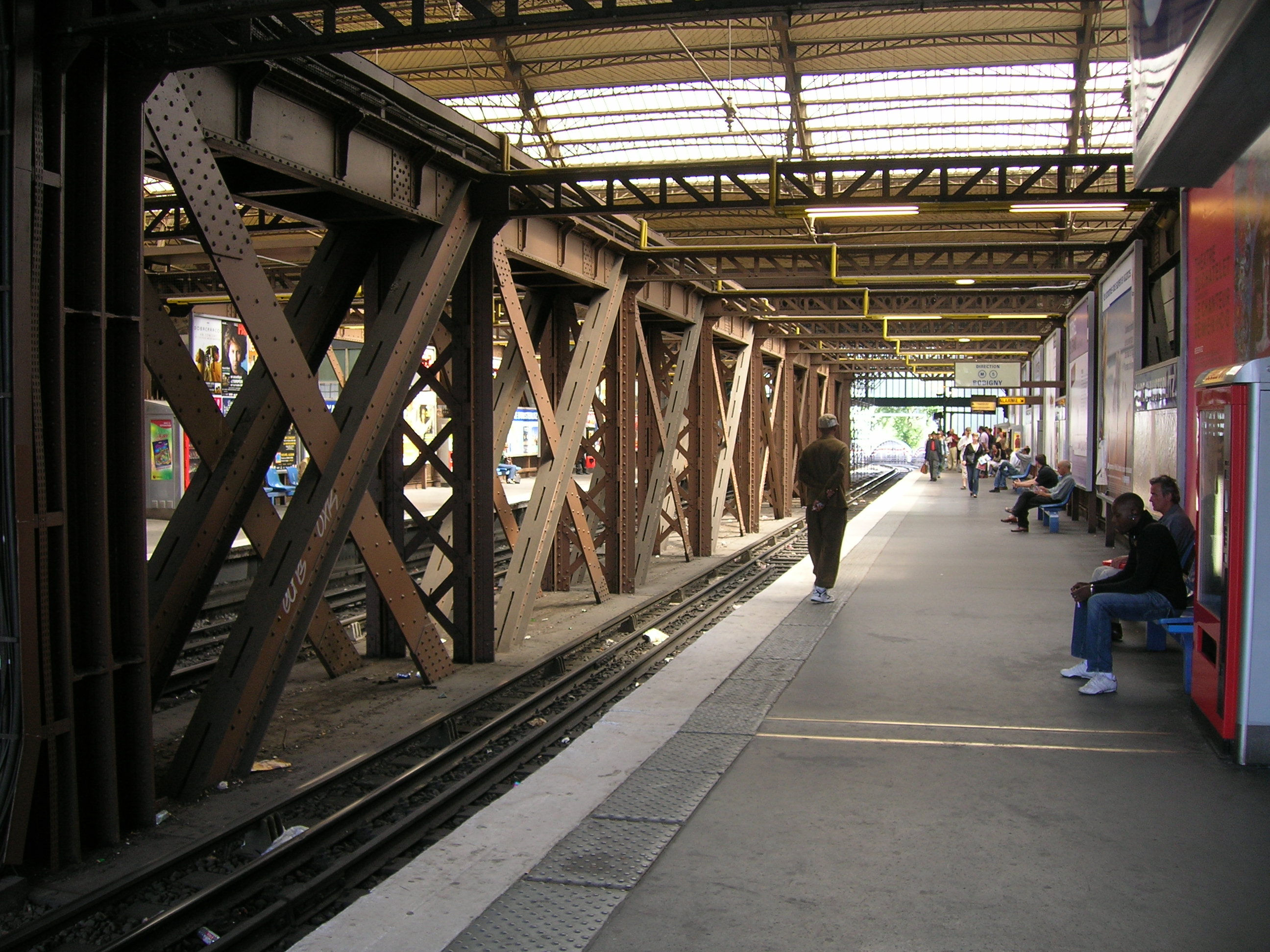
| | | | It will be helpful to again have a look at the older, 1939 Métro map, so we can compare it to the present map. Look to the right to find line 3, and note how its eastern end bent to the northeast after Gambetta and went for three more stops to Porte des Lilas. On the new map you can see the change that was made in 1971, when the line was altered to go due east after Gambetta for two more stops to Gallieni. The former end of the line then became a shuttle between those last stations, called line 3bis. At only 1.3 km and four stations long, it's the shortest Métro line and by far, the least used—and least known. Just like line 7bis (below) it has a somewhat creepy atmosphere, with few travelers and almost-deserted stations. Even the route map on the train looks lonesome (Photo by Clicsouris). | | | | On both the older and current maps, you'll see line 7 on the right pointing northeast. But from early on there was a branch running east from Louis Blanc (actually from Château-Landon) ending in a diamond-shaped loop. This less-used branch was cut off in 1967 and became line 7bis (Map by Metropolitan), which is now the second-shortest line in the system and second-to-last least used. | | | | As fate would have it, 3bis and 7bis are quite close to each other. Line 11 runs right between them, and could be a factor in any plans. So what should be done about cobbling 3bis and 7bis together into one? This map (Map by Greenski) might be a guide. | | | | Disregard Line 11 in brown passing through. 3bis in blue connects from the south, and 7bis in green connects from the west. In black, the two voies are, quite intriguingly, already existing connections between the two. The ghost station Haxo has never been used--though built underground, it has no connections to the street. | | | | What has been proposed is a connection of 3bis and 7bis (Map by 日本海&大韓海峡 at Japanese Wikipedia), extended one stop beyond Louis Blanc to Château Landon (an apparently preexisting connection, as indicated on the older map), which in turn is connected to the Gare de l'Est. It would most likely allow, finally, for the opening of Haxo. I can only assume that the connections between Porte des Lilas and Botzaris would be one-way each, as in that Passy route we discussed. | | | | But what can we experience in this area now? Well, quite a bit, by "faking" our own connections through the area. After the Austerlitz experience (see map, then keep on following), we stay on 5 beyond Bastille to République, then take 3 to Gambetta. We change trains there to 3bis and ride all of it (!) to Porte des Lilas. Then we take line 11 west two stops to Place des Fêtes, then take 7bis for ¾ of the way around the loop, and on to Louis Blanc. I tried to spot Haxo through the window when we passed where it should have been, but couldn't. Ghost station Haxo apparently looks like this (Photo by Gonioul). From Louis Blanc we take the 7 to Chausée d'Antin-La Fayette, then the 9 home to La Muette, which takes under a half-hour, so quickly can you zip across Paris. | | | | NYC Bits & Pieces In connection with this discussion, it seemed of interest to see the development of New York's similar bits and pieces. There are three of them, and all run as shuttles today. Most interesting is the 42nd Street Shuttle between Grand Central Station and Times Square, fully discussed in 2018/4 as the result of a transition of the IRT's "Z-system" to its "H-system".
http://newyorksurfinglessons.homestead.com/sub2a_op_800x518.jpg
| | | | Furthest away in distance, and of some interest, is the Rockaway Park Shuttle. It's the descendant of the Long Island Rail-Road route that once serviced the Rockaway peninsula in two directions (see the far right of the above map), splitting at a wye (a triangular junction) (Sketch by Erik Baas) after Broad Channel to serve Far Rockaway to the east and Rockaway Park to the west. In 1956, this entire rail route became part of the New York subway system. The normal Rockaway service is for the "A" train to go to Far Rockaway, leaving the Rockaway Park Shuttle to connect Broad Channel and Rockaway Park. However, somewhat belying the shuttle nature of this route, during rush hours, five "A" trains do provide service between Rockaway Park and Manhattan, but only in the peak direction. | | | | Finally, I find the Franklin Shuttle of particular interest. On the above subway map, be sure to notice how Coney Island in the late 19C-early 20C was such a prime destination for Manhattanites and for Brooklynites, then concentrated in northwest Brooklyn, that private rail companies rushed to provide their own route to Coney Island through what was then farmland. These are now NYC subway lines, but their parallel nature rushing to bring rail service the resort area remains obvious. | | | | On the map, find the Brighton Line, the easternmost line of those going to Coney Island. Then find Prospect Park and the Prospect Park Station, where the original railroad, the Brooklyn, Flatbush, and Coney Island Railway (BF&CI), began its route in 1878 to connect downtown Brooklyn with the hotels and resorts in Coney Island, Manhattan Beach, and Brighton Beach. The problem was, the eastern side of Prospect Park wasn't downtown Brooklyn.
http://cdn-sas.secondavenuesagas.com/wp-content/uploads/2010/09/BrooklynExcerpt.jpg
| | | | Even worse, as this detail map shows, is that to move northwest from the Prospect Park station you needed to run through the park, which was not allowed, so the railroad decided to instead build a spur through Crown Heights to connect to the Bedford Station of the LIRR (the station is gone, but the tracks of the still operating LIRR can be seen on the map). This spur today is the Franklin Avenue Line, housing the Franklin Shuttle. The railroad then contracted with the LIRR to run Brighton trains to what is today the Atlantic Terminal in downtown Brooklyn. But later, the LIRR acquired another route for itself to Coney Island and cancelled the agreement. With its trains now ending at Bedford, the BF&CI went bankrupt. | | | | Others took over the line, and in 1896, a connection was built with the Fulton Street Elevated (located where the blue subway is today), again providing direct service to Manhattan. In 1940, the elevated was replaced with the Fulton Street subway line, but a free transfer was instituted with the Franklin Shuttle, which is elevated at that end. | | | | But we're getting ahead of ourselves. In 1920, not being able to build across Prospect Park on the surface, the railroad built a subway from the Prospect Park station under Flatbush Avenue along Prospect Park (see detail map) to reach other main lines. Until 1940, there was service to Brighton either on the new route, or via Franklin Avenue (the Franklin-Brighton line). But the latter declined in use, and direct Franklin-Brighton services were ended by 1959 with the Franklin Avenue Line becoming a full-time shuttle in 1963.
http://www.vanshnookenraggen.com/_index/wp-content/uploads/2011/03/Franklin-Ave-Shuttle_small.png
| | | | But as in Paris, plans have been suggested to improve this shuttle situation by extending the Franklin Avenue Line beyond the Fulton Street subway to another station, then meeting the "G" train at the station at Bedford-Nostrand Avenues. | | | |
| |
|
|
|

