|
Reflections 2018
Series 8
August 18
Paris VI: Lines 6 & 2 Circle–Sacré Coeur–Montmartre–A Dusty Secret-Marne
| | Day 5 F8 – Lines 6 & 2 Circle, Sacré-Coeur, Montmartre, Marne As mentioned in the previous posting, today will be mostly spent in Montmartre, including the Sacré-Coeur. But we're not going there directly. Instead, we're going to take advantage of a circular Métro trip around the center of Paris. | | | | | | When the routes were being planned in the first decade of the 20C, the planners envisioned a single circular line, using as a model the Circle Line of the London Underground. But doing it that way proved impractical, so the route was divided in two.
Construction on London's Circle line started between 1863 and 1884, and from the beginning, trains ran continuously around its loop in both directions. But in 2009, a western "tail" was added to it, connecting Hammersmith with Edgeware Road. Rather than being purely circular, the route is now more like a backwards figure 9 (or 6). Trains now travel from Hammersmith to Edgeware Road and go around the circle once before terminating at Edgeware Road. They then backtrack all the way along the same route. But the circle still remains as a single route.
|
| | | | We refer again to the former Sixth Wall around Paris, the Wall of the Ferme Générale, shown here in blue (Map by ThePromenader). As described in 2017/17, Métro lines 6 & 2 together closely follow the route of this former wall, and there's actually quite a bit to see, since much of the two routes is above ground on viaducts. This is a geographically correct path (Map by Controlling) of Métro lines 6 (to the south, in green) and 2 (to the north, in blue), forming a circular route. We'll pick it up at Trocadéro to go to Montmartre, arriving at Anvers, then continue from Place Blanche to Étoile to continue our day. Thereby, we'll experience the entire route with the exception of Place Pigalle near Montmartre and Kléber and Boissière beyond Étoile. But it's easier to follow our trip on our Métro map, whose link is again below:
https://parisbytrain.com/wp-content/uploads/2014/01/paris-metro-geo-2014.pdf
| | | | From La Muette it's just two stops on the 9 to Trocadéro, which, you'll recall, is right below the Palais de Chaillot. There we change to the 6, and it's only one stop to where we "burst forth" from the "mountain" and stop outdoors at the Passy Station, illustrated in a previous posting. | | | | There are many bridges in Paris. Most are vehicular, and several are just pedestrian. But ● two are rail bridges and ● two have both a vehicular level and a rail viaduct. One of each is in western Paris and one of each is in eastern Paris. Here in the west, we've crossed (and walked under) the Pont Ruelle, the rail viaduct carrying RER C, and we've seen and walked under the Pont de Bir-Hakeim, dodging its vehicular traffic and seeing Métro line 6 crossing it. Today we'll ride line 6 over Bir-Hakeim (Photo by DXR). We know already it has spectacular views of the Eiffel Tower and the Seine, but great views continue; this is one of the most appreciated lines in Paris, since 45% of its route is elevated on a viaduct, more than any other. Thirteen out of 28 stations are thus out-of-doors. | | | | On our Métro map, find two stations coming up, Cambronne and Sèvres-Lecourbe. You can see that there are views from here to the Invalides. Also find the Montparnasse Tower in brown. Now take a look at this view of the Sèvres-Lecourbe station (Photo by MathTeacherGuy) taken from the Montparnasse Tower, with the Cambronne station in the background. The tree-lined boulevard at 2:00 leads back toward the Eiffel Tower, and the one at 3:00 leads toward the Invalides. | | | | The line goes underground at Pasteur, then comes up again at Saint-Jacques, after which the viaduct runs along the Boulevard Saint-Jacques (Photo by Mbzt). Curiously, the route then descends to street level in the middle of Boulevard Auguste-Blanqui just for the Corvisart station (Photo by Geralix), because the route has to go underground for just the following station, Place d'Italie, a major intersection. You see the tunnel entrance ahead in the picture. It then emerges again onto a viaduct to cross over all the tracks that lead north into the Gare d'Austerlitz. This is south of Austerlitz, not inside it, like we'll later see line 5 do. | | | | We said that in eastern Paris there's also ● a rail bridge and ● a bridge with both a vehicular level and a rail viaduct. Today we'll cross the Pont de Bercy, which has a rail viaduct for Métro line 6 over a vehicular roadway (line 6, as it turns out, crosses both these dual-service bridges over the Seine). And the Pont de Bercy (Photo by ignis) is just as attractive (click for detail) as the Pont de Bir-Hakeim. Here's a view along the viaduct (Photo by Pline)—note the lanterns—and here's a view through the arches (Photo by besopha). | | | | Tomorrow we'll ride line 5 on its viaduct through (!!) the Gare d'Austerlitz and then cross the Viaduc d'Austerlitz, a rail viaduct over the Seine (not to be confused with the adjacent Pont d'Austerlitz, a road bridge). But for now, once line 6 reaches Bercy, it's underground again to Daumesnil, where it emerges for a last time on a viaduct and makes a sharp curve to the left to cross over the former Vincennes rail line, today the Promenade Plantée (which we hike tomorrow). The Bel-Air station (Photo by Mbzt) is another one at street level, right in the middle of the Boulevard de Picpus. Finally, it's underground again between Picpus station and the Place de la Nation, the terminus of line 6. | | | | We change at Nation to line 2, which has only one stretch on a viaduct and so fewer ups and downs. It starts out underground, where it passes the famous Père Lachaise Cemetery. Its only viaduct begins after the Colonel Fabien station (Photo by Mbzt), which is underground, so on this view, we'll be exiting upwards from it on the track on the right. You'll recall from the last posting that this station is in the area of the gibbet, so we're not far from the Locks of the Dead. The next station, Jaurès, is located just above the Canal Saint-Martin, and accounts for that little extra tunnel the boat went through just before reaching the Bassin de la Villette. Leaving Jaurès station (Photo by Clicsouris)—we'd be on the track to the right--we reach the bend over the canal, and can already see the Rotonde ahead on the left (click).
https://files1.structurae.de/files/photos/1/20110328/dsc02373.jpg
| | | | Just past the Rotonde (above), we're at the Stalingrad station, named for the Place de la Bataille-de-Stalingrad (Battle of Stalingrad Square), but the prettier view of our train and viaduct is from the Rotonde side (Photo by Coyau/Wikimedia Commons/CC BY-SA 3.0). The last elevated station is Barbès-Rochechouart (Photo by Romain D C), seen here in the background, after which our train goes underground for the rest of its route, though we get off at the next stop, Anvers (Photo by Clicsouris). Our train lets us off on the left side here (click), headed toward Porte Dauphine. Since Anvers is the most accessible Métro station to the top of the Butte Montmartre, the station's name has a subheading indicating so (Photo by Clicsouris).
| | | | Check the Métro map again to see what we've just done and try to see where Montmartre is. After Montmartre, we'll get on again at Place Blanche (two stops west) to continue the circle to Étoile, after which we'll make one quick final stop of the day.
http://moon.com/wp-content/uploads/2014/06/MapGuideParis5e_09_Montmartre-966x1024.jpg
| | | | Sacré-Coeur & Montmartre We'll be using two maps of the area. This first one (click) we'll call the "big map" because it covers a larger area. The second map later will be more detailed as to the core of the area. Perhaps the roads you see here will help you estimate a circular area around the Butte Montmartre, or Montmartre Hill. While most of the interesting areas are up on the hill, the line of boulevards you see in pink to the south—here including Clichy and Rochechouart--are already known to us, and so should they be! If line 2 follows the northern arc of the Wall of the Ferme générale, and if we said in 2017/17 that the wall was replaced by boulevards, we have here the boulevards that I call the Second Ring. This means that just as Montmartre lay just to the north of the Wall, so it lies just to the north of the Second Ring and to the north of Métro line 2. | | | | | | Let me quote here the list of boulevards in the Second Ring I named in sequence in that posting, starting and ending at Étoile, but for now just including those names we've mentioned again in this current posting: . . . Clichy, Rochechouart, . . . la Villette, . . . Picpus, . . . Auguste-Blanqui, Saint-Jacques, . . . Montparnasse, Pasteur, . . . Kléber. . . |
| | | | We are going to mentally divide this walk into two parts. First we'll take the funicular up to the Sacré-Coeur and visit it. Then we'll cross an invisible mental wall I've built to reach the real Montmartre near the Place du Tertre, and walk downhill through the historic, charming village of Montmartre, lying to the west and northwest, where the most interesting locations are. Then we'll visit the cemetery down below, and end up at Place Blanche, passing by the Moulin Rouge cabaret. | | | | Check the map again to locate the Anvers station, whose exit is in the center of the Boulevard de Rochechouart. You see the adjacent greenspace, the Square d'Anvers (Antwerp) from which the station gets its name. To our great pleasure, we find that the station exit is one that includes one of the surviving landmarked Guimard exits (Photo by cherryguy93), the ultimate of turn-of-the-20C Art Nouveau structures built by Hector Guimard. I understand one of the most spectacular of his exits is at the very last stop of our line 2, at Porte Dauphine (Photo by Anthony Rauchen), though I've never seen it personally (click). | | | | On our "big map" you'll notice that we have a two-block uphill (puff-puff) walk on the Rue de Steinkerque to get to the park area where the funicular is. I read that, when they last were rebuilding the funicular, they considered extending it all the way down to the Anvers station, but it proved to be too expensive to do, so: puff-puff. While we're walking, let me explain the controversy about that big white building at the top of the hill and why I insist on maintaining that invisible mental wall up top. | | | | The Controversy When we travel, we tend to accept the sights we come across at face value. For instance, we know or hear about the Pont Neuf ("New Bridge") and are told it's the oldest bridge in Paris; we visit it, we love it, and we accept it. After all, who are we to quibble?
| | | | Well, with deeper knowledge beyond the superficial tourist ballyhoo, maybe we should quibble if and when we see a good reason to. What if we find out things are not exactly what we'd assumed for years? That's what happened to me right after this eighth trip to Paris as to an iconic touristic site, the Sacré-Coeur. You may disagree with my new outlook, but I'm adamant. It's the reason for my invisible mental wall at the top of the hill. | | | | I love Montmartre—the former village itself--and we'll walk it in detail. But now that I know the story of the building of the Sacré-Coeur, I'm quite displeased. To wit: (1) architecturally, it's an iconic, gorgeous, marvelous structure, but (2) it's misplaced, like a 900-pound gorilla at your dinner table. Furthermore, its misplacement is (3) based on highly unfortunate, right-wing, anti-democratic, Big Brother political considerations against the people of Montmartre. We have to look at the background of all this to see why Paris even today continues to have a problem with both this building and its location, as I do. | | | | The Basilica of the Sacred Heart, (Basilique du Sacré-Cœur), commonly known simply as the Sacré-Cœur (sa.kré.KÖR), is located on top of the Butte Montmartre, steps away from the highest natural point in Montmartre and in Paris, which we'll point out shortly. The church was financed by public subscription and built between 1876 and 1919, not only as a cultural monument, but with strong political overtones. Building it was precipitated by France's defeat in the Franco-Prussian war of 1870 and the rise of the Paris Commune in 1871. Thus, the history of the Basilica has been described as "tortured". | | | | The Paris Commune (La Commune de Paris) was a secular uprising, a radical socialist and revolutionary government that took over Paris (not France) for ten weeks from 18 March to 28 May 1871. Following the defeat of Napoleon III in September 1870, the Second French Empire promptly collapsed (see 2017/18 "French Governments"). While rightists wanted a new monarchy, leftists wanted the reestablishment of democracy after the autocratic Empire, and in place of the Empire rose the Third Republic (1870-1940). But this government, too, was still at war with Prussia, which laid siege to Paris for four months. Finally, reparations exacted by the Prussians, notably the loss of Alsace-Lorraine, resulted in social upheaval and the establishment of the Paris Commune. | | | | In 1871 France was deeply divided between the large rural, Catholic, conservative population of the French countryside and the more republican and radical cities of Paris, Marseille, Lyon and a few others. From the beginning, the Commune had a hostile relationship with the Catholic Church. On 2 April, soon after the Commune was established, it voted a decree accusing the Catholic Church of "complicity in the crimes of the monarchy." The decree declared the separation of church and state, confiscated the state funds allotted to the Church, seized the property of religious congregations, and ordered that Catholic schools cease religious education and become secular. During the period of the Commune, there were atrocities on both sides. Communards, hostages, and clergy were executed; Communards destroyed major monuments in Paris, including the City Hall, the column in Place Vendôme, and the Tuileries Palace. The latter was not rebuilt, even though it was only internally damaged by fire, since it was decided it had too many royal associations after all. A government building on the Left Bank was also not rebuilt, but replaced by the Gare d'Orsay, now the Musée d'Orsay. | | | | The Commune existed for too short a time to enact much of its program, but two decrees of interest that were implemented was the separation of church and state, and an early version of the abolition of night work in bakeries (see 2018/6 "baguette"). | | | | The uprising had begun in Montmartre. Government forces attacked there on 23 May, and by 28 May the Commune was finished. Yet attention was concentrated on a site on top of the butte where two government generals had been killed. Conservatives in the government had the National Assembly decree in 1873 that a new basilica would be built there, specifying that it was to be erected to "expiate the crimes of the Commune", a direct slap in the face for Montmartre. A law was passed to seize land at the summit for construction. But this was not the end of the controversy. There were passionate debates in the Municipal Council in 1880 where the basilica was called "an incessant provocation to civil war", and it was debated whether to rescind the law of 1873. In 1882 the matter reached the Chamber of Deputies, where the basilica was defended by Archbishop Guibert while Georges Clemenceau argued that the building sought to stigmatize the Revolution. Clemenceau had been the mayor of the 18th arrondissement, which included Montmartre, and was later Prime Minister of France and negotiator for the WWI peace treaty. In any case, the law WAS rescinded, but the basilica was saved by a technicality, and the bill was not reintroduced in the next session. A further attempt to halt the construction was defeated in 1897, by which time the construction was too far gone to stop. But the point remains that building this church, and in that very location, was never universally popular. | | | | The church was meant to be an embodiment of conservative moral order and a penance and atonement for the extremes of French history in all the eight decades since the Revolution a "century of moral decline", and penance especially for the destructive socialist Paris Commune of 1871 and for the most rebellious neighborhood where it all started, the adjacent village of Montmartre. This was the conservative argument presented to the government by royalists and clerics, and is stated as such in the resolutions the government passed—with great controversy—at the time. Put bluntly, it was not only built, but built in that specific location, to teach Montmartre a lesson. | | | | While accurate, that interpretation was severe, and for the benefit of the common mind, the Church softened its interpretation, so that today it's widely considered a monument merely for those who suffered and died over that period of time, particularly toward the end, in the Franco-Prussian War and in the Commune. This, of course, is a subsequent whitewash of the facts, but it seems to make people feel better. | | | | We noted in 2018/7 that the "concord" referred to in the Place de la Concorde, named in 1795, was a gesture of reconciliation between the levels of society after the turmoil of the Revolution in 1789. It can now be seen that the Sacré-Coeur was just the antithesis of the Place de la Concorde, where divisions remained between devout Catholics and royalists on one side, and democrats, secularists, socialists, and radicals on the other. You may think that this matter's settled. Well, the whole affair is beyond the ken of the everyday tourist, but I've found it's continued to simmer all along. | | | | To pursue the matter of the separation of church and state, way back in 1904, the Municipal Council of Paris chose to make an example the Chevalier de la Barre (François-Jean Lefebvre de la Barre). The Chevalier (who held that title, equivalent to "Knight") was a 19-year-old French nobleman condemned in 1766 for blasphemy and sacrilege. Various charges were dug up against him, the most notoriously remembered is that he hadn't taken his hat off when a Roman Catholic religious procession passed by. He was tortured, decapitated, then burned at the stake, in Abbéville, north of Paris. Voltaire, a leading critic of the Catholic Church, took up the Chevalier's cause, and helped make it into a cause célèbre, because a key piece of evidence against the Chevalier was that he owned a copy of Voltaire's banned book the Dictionnaire philosophique (Philosophical Dictionary), which criticized Roman Catholicism, Judaism, and Islam. Because of that, when he was being burned, they'd nailed a copy of that book to his torso. In France, he's widely regarded as a symbol of the victims of Christian religious intolerance, as well as a symbol of anticlericalism. That the Chevalier de la Barre was "rehabilitated" 27 years later in 1793 made little difference to the enormity of the event. | | | | Even Charles Dickens made reference to de la Barre, without naming him, in A Tale of Two Cities:
Under the guidance of her Christian pastors, she [France] entertained herself . . . with such humane achievements as sentencing a youth to have his hands cut off, his tongue torn out with pincers, and his body burned alive, because he had not kneeled down in the rain to do honour to a dirty procession of monks which passed within his view, at a distance of some fifty or sixty yards.
| | | | The Council of Paris back in 1904 was fiercely laic, and thus hostile to the basilica and its location. It joined with various freethinking organizations to establish a permanent protest, since nothing could be done any more about the building itself which was becoming a fait accompli. The Council managed to recover 5,000 sq m (about 6,000 sq yards) of land wrongfully retained by the Archdiocese and decided to award a 5,000-franc grant toward the completion of a statue of the Chevalier de la Barre. In 1906 the statue was cast in bronze and placed in line with the main portal of the Sacré-Coeur during a ceremony attended by 25,000. To show the vehemence of feeling, the statue was called "the antidote in front of poison". It's time now to present the "detail map" of Montmartre:
https://upload.wikimedia.org/wikipedia/commons/thumb/e/ea/Montmartre_OpenStreetMap.svg/2000px-Montmartre_OpenStreetMap.svg.png
| | | | Find the Sacré-Coeur and judge where the original statue was placed at the time of the original erection (both were later changed). This is a 1906 postcard showing it. But after two decades, the original statue was moved in 1926 to a less provocative location nearby, to the west end of the Square Nadar (see map), at a few steps lower in elevation. But then as happens when political controversy is involved, during the Nazi occupation of Paris, in 1941 the rightist Vichy government toppled the statue and had it melted down, but, not surprisingly, kept the statues of kings and saints. | | | | It then took six decades until the Paris City Council decided in 2001 to erect a new statue of the Chevalier de la Barre in Square Nadar (Photo by Jim Linwood). Click to read the inscription, which translates as "To the Chevalier de la Barre, tortured to death at the age of 19 years the 1st July 1766 for not having saluted a procession". It doesn't mention what sort of procession that was. To this day, the name of this victim of religious intolerance, and his statue, remain a rallying point for free thinkers. Chevalier de la Barre Day, 1 July, mainly a French observance, is a day that can be celebrated by anyone who opposes religious oppression. | | | | That original statue wasn't the only symbol of protest at the turn of the century. Look at the detail map and check out the street that runs east-west for three longish blocks just north of the Sacré-Coeur. In 1907, as a political action, the Municipal Council decided to change the name of that street to the Rue du Chevalier-de-la-Barre. To add insult to injury, the street address of the Sacré-Coeur, used for postal purposes for anyone contacting the church, is 35 Rue du Chavalier-de-la-Barre! (Photo by Benoît Prieur - CC-BY-SA). Libre Penseur is "Free Thinker". I have also seen a list of 65 cities in France, including Paris, that have a street named after the Chevalier de la Barre. | | | | | | Other than the statue honoring him at the Sacré-Coeur, we have to mention Abbéville. A monument to him was first erected at his execution site in Abbéville in 1907 with funds collected by voluntary subscription. It's in the form of an obelisk with a plaque depicting his death (Photo by Emmanuelhammel), with an inscription (click) almost the same as in Paris. During the Nazi occupation in WWII, the plaque was temporarily removed for safekeeping (remember what happened to the original Paris statue) and hidden in a creek. |
| | | | We're still not quite done with the controversy. One more name has appeared in protest, and relatively recently. On the detail map, note that the street at the bottom of the large cliff-side park below the church is to this day called Place Saint-Pierre. On that basis, the whole sloping park from that street almost to the church was originally called Square Saint-Pierre. But in 1927, it was renamed Square Willette, after Adolphe Willette, a well-known painter, illustrator, poster-maker, lithographer, and caricaturist. He decorated salon in the Paris City Hall and numerous cabarets and restaurants in Montmartre. Quite notably, in 1889 he decorated the Moulin Rouge ("Red Mill"), and designed the famous windmill above it. | | | | But in 2004, the Council took notice of the fact that Willette was a virulent antisemite. Not only that, during the 1889 legislative elections, he ran as self-declared Candidat Antisémite, as proclaimed in this election poster, which states that "The Jews are only big because we are on our knees! Let's stand up! . . . It's not a question of religion. The Jew is of a different race and an enemy of ours. Judaism, there's the enemy!" He goes on with that drivel, and this is as bad as anything the Nazis produced. As a matter of fact, this poster was reproduced again in 1942-1943 during the Occupation. | | | | It's a wonder the Council of Paris waited so long to finally remove Willette's name from the park, but in 2004, it was renamed Square Louise-Michel. (Both our maps still show Willette's name in part or in whole on the park, but Google maps show that the entire area is now Square Louise-Michel.) But do realize that the woman the council chose to rename the park was someone very specific to Montmartre and to the Commune, as she was one of the major figures and a leader of the Communards. While the Council insisted in naming the park after her it was renewing the memory of the thousands of dead and exiled during the struggles of the Commune. Of course, that's just what the church also later claimed when its stance was modified from teaching Montmartre a lesson to the Sacré-Coeur being a general memorial. Yet there's some sweet justice in having the large park of which the Sacré-Coeur is the backdrop (Photo by Daniel Lobo) named for a leader of the Commune. | | | | Climbing uphill, we've reached the classic ensemble uphill view from Place Saint-Pierre of the Square Louise-Michel and the Sacré-Coeur above it (Photo by Superchilum). But perhaps you'll now understand the ongoing controversy, why I'm less enthusiastic about the Sacré-Coeur than I was in the past, and why I've erected that mental invisible wall separating it from the genuine Montmartre. | | | | It's a delightful scene, yet strictly speaking it's only the back door entrance to Montmartre. Click to inspect all those steps—there are roughly 300 steps per staircase. The funicular is to the left—check that on the detail map—and there's another staircase adjacent to it. But with all the red staircases you see, there is only pedestrian access to get up top, either on foot or by funicular. There are no vehicular routes here, so before the park and the funicular, this was the side of a cliff with no access to the village of Montmartre whatsoever. Apparently all this pedestrian access was provided at this back door only because the Sacré-Coeur was built. Would you guess they'd have built a funicular just for village access? Maybe, but I doubt it. Village access was always from the western side of the Butte, and I've found some precise routes, discussed below. But we're here, anyway, to ride the updated version of the funicular, and en passant, stop in at the Sacré-Coeur. Actually, this is not a trip where we revisit all the monuments—the Eiffel Tower, the Louvre, Notre-Dame. At best, we see them from a distance. But we'll be right at the church, so we'll discuss it and stop in. | | | | Le Funiculaire de Montmartre I have to adjust my thinking about the engineering of bridges and funiculars. In the past couple of years, I've been so enthusiastic in discovering beautiful cable-stayed bridges on the Mississippi, the Hudson, and elsewhere. Now I have to realize that they're the norm, and you no longer see new suspension bridges. | | | | As for funiculars, I got my first surprise when I found that the Funiculaire de Québec had been rebuilt as a pair of inclined elevators. (Reminder: a funicular has one track with a passing area; its two cars counterbalance each other. An inclined elevator has one or two independent cars, each one having its own counterweights running below its tracks.) Then I saw the new construction at the Hudson Yards 34th Street station which had two inclined elevators set apart from each other. I noted at the time that I was surprised to find out that even the famous Funiculaire de Montmartre that I'd ridden in the past had been built as a pair of ascenseurs inclinés. Actually some funiculars have always been called inclines, as in Pittsburgh. So now I accept the two terms as interchangeable, though I feel that funicular remains the traditional umbrella term to describe both variations of a ride up a hill. | | | | The Montmartre Funicular was opened in 1900 (click to see that this postcard was canceled in 1906). The original one was water-powered, using cisterns that were filled or emptied to counterbalance the cars. I would love to have seen how that was done. It's just conjecture, but could that be a cistern below the car? I would imagine you'd fill water into a tank on a car at the top, carrying passengers, then lower it on a cable so it drags a passenger car up from the bottom with an emptied cistern, but with passengers. The system was entirely rebuilt and electrified in 1935, then rebuilt again in 1991. | | | | This sketch (Sketch by Pinpin) shows in brown the original ground level, and in gray the current ground level. Both stations were dug into the ground, explaining why the cars (red dashes) don't go any closer to the Sacré-Coeur—there's less of a slope at the top. The numbers above the sketch show the slope increases slightly the higher you go. At 108 m (354 ft) in length, the funicular climbs or drops the 36 m (118 ft) of altitude in under a minute and a half. It carries 6,000 people a day, or around 2 million a year. Each of its two cabins carries 60 passengers. Fully loaded (not always the case), it has the capability of carrying 2,000 passengers per hour in each direction. Both stations and both cabins use a great deal of glass and picture windows for maximum visibility. | | | | But this isn't your grandpa's funicular. It has all the sleekness of the most updated Métro train. You walk up to the lower station (Photo by MOSSOT) and already note the extensive use of glass. The only employee, like in a Métro station, is there on the side behind a window, for problems. You can buy a ticket from a machine if you don't have one—it's the same ticket as for the Métro. Note the two cabins and the foreshortened view of the upper station. | | | | Otherwise, you go through the turnstiles (Photo by laszlo tihanyi)—I used my Paris Visite pass—and find yourself in the waiting area between cabins. There are glass platform doors on either side, as in the latest Métro stations. Note the countdown clock, now on many subway stations in New York, London, Paris, and elsewhere, but which I've never seen before on a funicular. It's easier to read if you click on this picture (Photo by Mippzon). It's the greatest thing since sliced bread. The display board reads "PLACES LIBRES 05" telling the remaining number of free places on the next cabin, then "PROCHAIN DÉPART" telling the next departure. I loved that when I was there, and assumed that entering via the turnstile was what registered on the countdown clock. Not so. I now learn that the system is so amazingly automatic that the number of passengers is detected via scales on each cabin's floor plus radar in the stations, and a computer determines the departure, even when the cabin isn't full, as was so in my case. Unbelievable.
| | | | Here's a view of a sleek, modern cabin from below (Photo by François Trazzi) and one from above (Photo by Agateller). This last one shows the adjacent steps, and gives a preview of the city view from the butte. Here we approach the upper station (click) at the Sacré-Coeur (Photo by Peter Potrowl). Everything is automated, and there are no employees in sight. This is a YouTube video (1:15) of the funicular descending and ascending. | | | | Sacré-Coeur I said earlier about the Sacré-Coeur that "architecturally, it's an iconic, gorgeous, marvelous structure". Among its iconic features is that you can see it from seemingly "everywhere", a feature we've also noted about the Eiffel Tower. When we were looking at the Tower from Chaillot, a glance to the left from that same location showed us the Sacré-Coeur in the far distance, up at the top of the butte, particularly visible because of its whiteness. This is a similar view from the top of Notre-Dame. Even when one's closer to Montmartre, it's always right up there (Both Photos by Myrabella). Click for detail of the Square Louise-Michel, and for the church itself. This view is particularly good in showing what I think is its greatest feature, its front façade facing south with the beautiful groupings of domes and towers. When closer, the view will be at a steep angle (Photo by Tonchino) that foreshortens the startling height of the building, but that's attractive in its own way. Click to note the two equestrian statues that appear green (King [Saint] Louis IX & Joan of Arc). These were spared in 1941 when the Vichy Government toppled and melted down the original statue of the Chevalier de la Barre.
| | | | I've read that the overall style shows a free interpretation of both Roman and Byzantine styles. Perhaps, but given the time period of the building's erection, I see the influence of Art Nouveau, in its free-flowing, serpentine lines. In any case, it was a conscious reaction to the neo-Baroque style of the Palais Garnier (l'Opéra)—see that picture we used in 2017/17 of both the Opéra and the Grand Hotel. | | | | But perhaps the most striking thing about the style of the building is its total whiteness. The building material is travertine, a sedimentary rock, usually white, that's a form of limestone, or calcium carbonate, deposited by mineral springs, most notably hot springs. This is a travertine deposit at a hot spring in Turkey (Photo by Adilahredzuan001). | | | | The south façade, the free-flowing lines, the travertine building material, that's what I greatly admire about the Sacré-Coeur. On the other hand, while many churches are beautiful from all sides, I personally don't particularly care for the side or rear views of the Sacré-Coeur (Photo by Siren-Com), as seen here from the southwest. Ideally, it's seen from a distance or up front. When we walk up the last steps to the church, we're checked by security guards, a sign of the times. Inside, the view down the nave (Photo by Didier B) of the choir, apse, and mosaic is quite nice, but in the side chapels the incessant whiteness doesn't work as well as it does outside. Click to inspect the mosaic, in which I espy some influence of the Orthodox Church; if that's so, I'm sure it was not intended. I will add that Michelin gives the Sacré-Coeur only two stars out of a possible three, while all the other big icons of Paris get three. I think they know what they're talking about. | | | | But then you go out on the parvis (terrace—see map) in front of the Sacré-Cœur, are totally bowled over by the city view over Paris (Photo by [WT-shared] Riggwelter at wts.wikivoyage), though we are here at midday and this is an evening view. We also have here a (click) panorama (Photo by © Roman Eisele/Wikimedia Commons/CC BY-SA 3.0 & GFDL ≥ 1.2). | | | | Montmartre As a place name, Mons Martis ("Mount of Mars"), referring to the Roman god, survived into the era of the Merovingian Franks, 5C-8C, and that today has become "Montmartre". I see the following as the explanation. In the Middle Ages, in addition to the form martyr as is still used today, the form martre was also used in French, so that Montmartre would literally correspond to Mount Martyr by way of Mont des Martres, or Mont des Martyrs ("Mount of Martyrs"). The question is, how did the change come about? It could have been accidental, another example of folk etymology, the confusion of a Latin word unknown to the general public, Martis, for a word more recognizable at that time, martre(s). But it also could have been deliberate. Early on, there was a nearby chapel dedicated to martyred saints, particularly Saint Denis who was decapitated here, and his two sainted companions, and by 835 the area was already spoken of as the Mont des Martyrs. Given this coincidental situation, clerics could have been happy to obscure the non-Christian origin of the earlier Roman name and Christianize it, by presenting the name to the public, largely illiterate at the time, as an homage to martyred Christian saints. I lean towards this latter explanation.
| | | | Look at the detail map. As we leave the parvis with its view and walk westward, we cross a side street. I mentally draw a straight north-south line along this street as my invisible wall. The Square Nadar with its statue of the Chevalier, the funicular, and the upcoming Église Saint-Pierre are all on the good side of my wall. As we cross it, we are entering the genuine Montmartre. We pull around toward St-Pierre and the Place du Tertre, and an amazing thing occurs—this really did happen. Sitting on the stool on the sidewalk to our right an accordionist is playing—what else—Édith Piaf's La vie en rose, setting up the perfect atmosphere for entering the real Montmartre. I know it's not real. Parisians don't really sit around playing instruments for visitors. The musician just claimed this bit of sidewalk for his gig. But who cares? It works anyway. Here, get into the mood with a little bit of this YouTube video of an accordion playing La vie en rose. | | | | Église Saint-Pierre de Montmartre The Church of Saint Peter of Montmartre is the last surviving vestige of the great Abbey of Montmartre, and is one of the oldest surviving churches in Paris, yet the lesser known of the two main churches at the top of the Butte Montmartre, the other being the you-know-what. Surprisingly, the back of Saint-Pierre faces that other venue (Photo by James@hopgrove). Ahead of Saint-Pierre (click) and just to the left (south) you see the trees of the Place du Tertre. I'm abashed to say that this is only my first visit to Saint-Pierre, as close as it is to the Place du Tertre. | | | | Abutting Saint-Pierre immediately to the north is the Cimetière du Calvaire (Calvary Cemetery)--see map--which contains the highest natural point of Montmartre and of Paris at 130.53 m (428.25 ft). However, Belleville, in northeast Paris, would argue that, since it comes in so close. A point, coincidentally in the Cimetière de Belleville comes in close, at 128.64 m (422.05 ft). | | | | Archaeological excavations show that the heights of Montmartre were occupied from at least Gallo-Roman times. In northern Montmartre, vestiges of 2C Roman baths have been found. Excavations near Saint-Pierre found 3C coins and remains of a major wall were found in its garden that are associated with the templum Martis (Temple of Mars). | | | | It's the oldest post-revolutionary parish church in Paris, after Saint-Germain-des-Prés. Its origins go back to the 6C, the time of the Merovingian Franks (5C-8C). This is indicated by the five Merovingian white marble capitals and four columns still used in the present, rebuilt church, the columns in turn coming from an ancient temple. The church was a pilgrimage stop in the 9C and it was severely damaged and rebuilt several times. Its apse has the oldest pointed arches in Paris, dating from 1147. This is a detail of its east side, with the apse and bell tower (Photo by Stephen Lea). It was finally largely destroyed during the French Revolution, but was rebuilt as it looks today between 1900 and 1905, so much of it is a restoration. The contrast between the dignified, serene, ancient Saint-Pierre, and the bombastic "look-at-me" newcomer, the Sacré-Coeur, couldn't be more different. | | | | This is the nave and choir--click for details (Photo by Myrabella/Wikimedia Commons/CC BY-SA 3.0). This is one of the ancient columns (Photo by Benchaum), and these are some of the Merovingian white marble capitals, blackened with age (Photo by Pierre Poschadel). | | | | From Saint-Pierre we cross Rue du Mont-Cénis, and immediately first come across the side view of La Bohème we saw and discussed in the last posting (Photo by Olivier Bruchez), and turn the corner to its left to enter the square. | | | | Place du Tertre We already mentioned in the last posting this epicenter of old Montmartre, the
Place du Tertre and used this map to show it (Map by Paris 16). As often as I'd been there, I only learned on this trip that it had been the town hall square of old Montmartre when the village was established in 1790, with the original city hall having been located there, I believe in the southeast corner, at #5, although I didn't actually see this plaque (Photo by Benoît Prieur-CC-BY-SA). It's quaint, and charming, and tourists are drawn there to the artists at their easels (Photo by FOTO:FORTEPAN / A R). Some of them do tourist portraits.
| | | | | | Since I first visited the Place du Tertre as a 17-year-old in 1957, I've wondered about the name. Beyond that, I've been confused about the various words for "hill" we've been coming across. We were at the Colline de Chaillot; the Montgolfier balloon landed on the Butte aux Cailles, and we're on the Butte Montmartre. I find that colline (compare Spanish colina) is a borrowing from Italian collina "hill", but butte also means a hill (borrowed into English in general; note the city of Butte, Montana). When I look up tertre it's a "mound"—or a hill. All three seem to be synonyms, though it's a puzzle why the top of the Butte Montmartre is called a tertre. In any case, my decision is that the Place du Tertre is literally "Hill Square", but is better rendered as "Hilltop Square". |
| | | | I've never seen the square when it's totally open in the winter for general public use (Photo by KimonBerlin). What I mean by that is the fact that, in warmer weather, the adjacent restaurants take over much of the square with their outdoor seating (Photo by Mister No) and crowd other activity to the edges. I was there on 8 September this trip; the picture was taken on the 12 September a few years earlier. I also mentioned this in Passy and at Les Deux Magots. | | | | Note on our little map that the most intriguing part of the Place du Tertre are the venues on its north side. It's actually part of Rue Norvins, which leads to the left down the hill. We'll mention La Mère Catherine (Mother Catherine), which was founded in 1793 (Photo by Britchi Mirela). Note those two signs on the upper right, here in detail (Photo by filip). I don't know, but I suspect the blue sign's referring to the "Free Commune of Old Montmartre" could have something to do with the Communards, but click to read the white plaque saying that "On 24 September 1966 Montmartre celebrated the Sixth Centenary of the Place du Tertre: 1366-1966". It's here we have authenticity regarding Montmartre. | | | | To the right is a colorful restaurant, Au Cadet de Gascogne (The Gascony Cadet) (Photo by Maria Eklind), and that red awning to its right is part of La Bohème [du Tertre] on the corner (Photo by Aicha Haddar), discussed in the last posting. Though this is an attractive enough picture, look at the awkward difference in scale. Isn't this King Kong peering into your window? | | | | Rue Norvins Check our detail map to see that the Rue Norvins that we're taking—it's a proper name—leads downhill to the west (Photo by ho visto nina volare). Its name first appeared on a map in 1672, which might explain its small size and quaintness. After one longish block, we come to an intersection (Photo by zoetnet) so steeped in art history and charm that we feel compelled to stop and sit down on one of the traffic bollards on the left (literally) to absorb the passing scene. First, we have across the way, the historic café, Le Consulat. It was visited by Picasso, Sisley, Van Gogh, Toulouse-Lautrec and Monet to name just a few. | | | | Orient yourself to two things here. Our next move will be to take the turnoff to the left, the Rue des Saules, leading to the northwest of Montmartre, past À la Bonne Franquette, in front of which is another narrow street, Rue Saint-Rustique. Behind the camera, the road continues to zigzag down the hill past a couple of parks (check the map). Before we proceed we'll first discuss what's down there, but needn't visit it. | | | | When one thinks of Montmartre, the imagery that comes to mind first is not the Gallo-Roman period, nor the modern one, as evidenced by the sleek new funicular. One probably envisions the era of the artists—alas, long gone—the era of the Belle Époque. We've already noticed the artistic life of Montmartre at the Place du Tertre, but we should discuss its high point. | | | | The Belle Époque ("Beautiful Epoch") is conventionally dated from the end of the Franco-Prussian War in 1871 to the outbreak of WWI in 1914. Occurring during the era of the Third Republic, it was a period characterized by economic prosperity and technological, scientific, and cultural innovations. The period was named as such only after WWI, in retrospect. The sense at the time seems to have been "the good old days" before the War. Especially in Paris, the arts flourished and many notable artists lived and worked in Montmartre, where the rents were low and the atmosphere congenial. | | | | Le Bateau-Lavoir If you look at our map and zigzag downhill behind where the camera was, you'll pass one park and then come to the Place Émile-Goudeau. There's a building bordering the western side of the park area in the square at 13 Rue Ravignan called the Bateau-Lavoir (ba.toh.la.VWAR). That's the established nickname for a building that is famous in art history as the residence and meeting place for a group of outstanding early 20C artists, men of letters, theater people, and art dealers. | | | | | | The nickname actually means "The Boat Wash-House", a place to service a boat. The name was coined because at the time, the building was so dark and dirty, it seemed like shack rather than a residence. In bad weather, it swayed and creaked, reminiscent of boat-cleaning facilities on the Seine, as in this photograph. (In addition, I can't believe my luck in finding this 1871 painting by Renoir called Bateau-lavoir sur la Seine.) |
| | | | Pablo Picasso took up residence there sometime between 1900 and 1904. After that, more artists and writers moved in, including Amedeo Modigliani. It was almost like a clubhouse that included artists like Henri Matisse, Georges Braque, Raoul Dufy, and Maurice Utrillo; also writers Guillaume Apollinaire, Jean Cocteau, and Gertrude Stein; also actors and art dealers. | | | | While living at the Bateau-Lavoir, Picasso painted several works of importance, such as Garçon à la Pipe (Boy With Pipe), 1905, private collection, and one of his most noted works, Les Demoiselles d'Avignon (The Damsels of Avignon), 1907, MoMA, New York, which is considered by art historians to be the precursor of Cubism. | | | | But as I see it, there is "little to see" at the site today. A fire in 1970 destroyed the building, leaving only the façade. It was rebuilt in 1978, and today encompasses 25 artists' studios. This is the street façade (Photo by Kalashni), but it's an optical illusion. The land slopes behind the building, and so this is really the upper floor—the actual ground floor is hidden, and exists only in the back. Note on the left the triangular historical marker and the dark door frame, as this next picture is a continuation, since there is a show window next door dedicated to the Bateau-Lavoir (Photo by David McSpadden). | | | | Rue des Saules But let's get back to that bollard we're sitting on where the Rue des Saules (sounds like "sole" and means "Willows") takes off to the left. It too appeared on that 1672 map, so it's been here a while. After a short straightaway, it descends sharply down the north slope of Montmartre, though we won't go that far. We have several things to see along this street.
| | | | Rue Saint-Rustique You saw how narrow that café, Le Consulat was. Well as we turn left into Rue des Saules (Photo by zoetnet), seen plunging way downhill up ahead (click), it's no more than ten steps from our bollard before we see on the right Rue Saint-Rustique (Photo by Britchi Mirela) located between the two corner venues. And we have the same view as Maurice Utrillo painted it in the early 20C:
http://www.artnet.com/WebServices/images/ll00130lldeX9GFg0J842CfDrCWvaHBOc2yGE/maurice-utrillo-rue-saint-rustique-a-montmartre.jpg
| | | | Rue Saint-Rustique (Photo by Moonik) is the oldest street in Montmartre, understandable when you consider that it leads, at its far end opposite us, to the cemetery that includes the high point of the butte. The picture shows its extreme narrowness, reflecting its age. There are no sidewalks and it has large cobblestones with a drainage area down the center. As part of the former village of Montmartre, it existed before the 11C as a path, then served as an alley dividing feudal manors. It was called Rue Notre-Dame around 1516, and was also included on that 1672 map we've been mentioning. In 1973 it became the first official pedestrian street in Paris. As for its name, it's a reference to the supposed martyrdom in Montmartre of Saint Denis, along with his companions, Saint Rustique and Saint Éleuthère. | | | | À la Bonne Franquette Back at the corner of Rustique, and opposite Le Consulat is À la Bonne Franquette (Photo by flightlog), also important in art history. I was puzzled about the odd name, and looked it up. It's an idiomatic expression, and is the only way the word franquette is ever used. The phrase means "without any fuss, simply, without ceremony". I have to guess they're trying to impart a homey atmosphere by using that name. Though Michelin had already alerted me to look for this inn, it was that sign (Photo by GFreihalter) that caught my attention (click), and I clearly remember reading every word, as follows: | | | | | | Since 1925; La Bonne Franquette, formerly "Aux Billiards en Bois" ["The Wooden Billiard Balls"]; This inn has been famous since 1890; [An] artists' meeting place, it has welcomed Diaz [?], Pissaro, Sisley, Degas, Cézanne, Toulouse-Lautrec, Renoir, Monet, Zola . . . , Its garden served as the model for Van Gogh for his famous painting "La Guinguette", painted in October 1886 and now displayed in the Musée d'Orsay |
| | | | This is Van Gogh's painting, whose full title is La Guinguette, terrasse d'un café en Montmartre, painted right here in 1886 in the garden terrace. As for the word guinguette, it's something that was once quite common and well-known, but which doesn't really exist anymore. It was, in the beginning, sort of a cabaret for every-day people, serving as a restaurant and often as a dance-hall, especially for Sunday day trips. They were usually found out of town in the suburbs (in 1886, Montmartre was well from the city center), often along the Seine or Marne. We'll come across another guinguette in Montmartre shortly.
http://www.epicureanpiranha.com/wp-content/uploads/2010/05/Montmartre-A-La-Bonne-Franquette-Aux-Billards-en-Bois.jpg
| | | | But the restaurant was, as mentioned, redone in 1925. When Van Gogh painted La Guinguette, it was still called Aux billiards en bois, as in the above picture with the staff posing at the entrance on Rustique. But then we continue down steep Rue des Saules (Photo by Britchi Mirela), where everybody can use a bollard—or a step—to relax. Click to see the two signs leading to La Terrasse, but I didn't make a stop there. | | | | Rue Cortot Check our map to see that the next side street on the right is the Rue Cortot, a proper name (Photo by David McSpadden). Saules is plunging downhill so rapidly, that at this point, it's an uphill walk up Cortot. But look up the street on the left to a large white building (click). It's the Musée de Montmartre (Photo by Tangopaso), seen here looking back down toward Saules to the left. It apparently has a local collection housed in two three-century old buildings, but is known historically for another reason. | | | | Between 1875 and 1877, Auguste Renoir rented a studio here, two attic rooms and a former stable on the ground floor, for his canvases and easel. During his stay he painted several major works, including three in 1876: Bal du Moulin de la Galette, which we'll discuss when we get there shortly; La Balançoire (The Swing) (Derivative Photo by Themadchopper), today in the Musée d'Orsay; and a view of the garden in the building, Le Jardin de la rue Cortot à Montmartre, today in the Carnegie Museum of Art, Pittsburgh. There are actually three gardens in the museum and they've been renovated guided by Renoir’s paintings. They've also been named for him, the Jardins Renoir, and based on the downward slope we've been seeing of Saules, apparently offer a good view of the cityscape to the north. | | | | But the building also had a number of other lesser-known artists, one name I recognize being that of Raoul Dufy. But particularly interesting is the fact that between 1906 and 1914, Suzanne Valadon and her son Maurice Utrillo lived there. This is her studio as seen from the Renoir Gardens (Photo by Tangopaso) and this is the view from her studio (Photo by Yann Caradec) over the northern cityscape. Suzanne Valadon was an artist, who I frankly never heard of. But Utrillo is unique, in that, of all the famous artists associated with Montmartre, he was the only one that was actually born here. | | | | Suzanne Valadon also was a model for many other Montmartre painters, including Renoir, Toulouse-Lautrec, and Van Gogh, and was also the mistress of many. She also never let on who the father of her son was, meaning he might have had two parents who were artists. But in any case, he grew up surrounded by artist role models. He was born as Maurice Valadon, and is probably not the son of the Catalan painter Miguel Utrillo, one of his mother's lovers, who nevertheless acknowledged him in 1891 and gave him his name. Being younger than all the impressionist painters, he lived into the mid-20C and developed a post-impressionist style. This is Maurice Utrillo's La Rue Norvins à Montmartre, c 1910. | | | | La Vigne de Montmartre Back on Saules, we pass something most people find quite surprising, La Vigne de Montmartre (The Montmartre Vineyard) at the intersection of Saules (right) and Rue Saint-Vincent (left)—check this out on our map. The Jardins Renoir (click to see the white building) apparently also provide a good view of the vineyard, which has existed since the Middle Ages but which was replanted in 1933. It really functions, and I understand its wine, officially named Clos-Monmartre, is quite expensive; the earnings are used to help social institutions. But I've also read that New York Times claims the vineyard is said to make the most expensive bad wine in the city. These are grape clusters just before the September harvest (Both photos by Tangopaso), right at this time of the year. | | | | On the other hand, this is a view down from the top of the vineyard (Photo by Shadowgate). Saules enters from the left and beyond the intersection, gets so steep further down the hill that it's for pedestrians only and turns into steps, so vehicular traffic is banned. That's the reason for the huge bollards blocking Saules (click). Saint-Vincent is to the right. At the intersection note the pink-and-white building with the funny green fence with yellow tips. As the sign says, it's the Lapin Agile. It wraps around the corner, but mostly faces Saules. | | | | Au Lapin Agile Here's a closer view from the intersection with the bollards of the curious-looking Lapin Agile (Photo by David McSpadden). Click to inspect the rabbit sign. And here's a closer view still explaining that it's a Cabaret artistique (Photo by Md.altaf.rahman) offering Poèmes et Chansons. I don't know about the poems, but Beverly and I have enjoyed the songs, and singing along.
| | | | Au Lapin Agile is a still-active cabaret established in the second half of the 19C. It had existed under other names since c1860, but in the 1870s, the current owner commissioned the caricaturist known by the pseudonym André Gill (ZHIL, rhymes with "hill") to make him a sign. Gill painted a rabbit wearing a green coat and red sash escaping from the cooking pot he was destined for. Because of the sign and the artist, the cabaret then became known as Au Lapin à Gill, or Gill's Rabbit. But the rabbit was quite agile hopping out of the pot, and people, maybe humorously, maybe accidentally, began interpreting the name homophonically as actually being Au Lapin Agile, which sounds exactly the same, but means The Agile Rabbit. The original painting on canvas was stolen in 1893 and a reproduction on wood was painted to replace it. In the late 19C and early 20C, the Lapin Agile quickly became "a veritable cultural institution" of bohemian life in Montmartre. It also became a favorite spot for struggling artists and writers, including Picasso, Modigliani, Utrillo, and Apollinaire. | | | | Now we come to the point where an artist that frequented a venue helped make it famous. This is Pablo Picasso's 1905 oil painting Au Lapin Agile: Arlequin au verre (At the Lapin Agile: Harlequin with a Glass). It was painted right at the counter, where Picasso depicts himself dressed as a Harlequin, accompanied by his recent lover Germaine Pichot. The painting was commissioned by the then owner, Frédé Gérard, seen playing guitar in the background. It was displayed at the Lapin Agile, where it was the only work by Picasso on permanent view in Paris from 1905 until 1912. Today it's in the Metropolitan Museum of Art in New York. Maurice Utrillo also painted a number of pictures of the Lapin Agile. | | | | | | Frédé Gérard, the then owner, was an odd-ball character. He was described as dressing like a cross between Robinson Crusoe, an Alaskan fur trapper, and a Calabrian bandit. He was surrounded by his animals, most notably, his mule. He's often seen playing his guitar. |
| | | | In more contemporary times, 1993, Steve Martin wrote a play called "Picasso at the Lapin Agile", which Beverly and I saw at an off-Broadway theater on the Upper West Side of New York. The play depicts an imagined encounter between Picasso and Albert Einstein in 1904 at the Lapin Agile. | | | | Another work by Picasso from this period, 1904, touching on a subject we recently discussed, is Femme a la corneille (Woman with a Crow), today in the Toledo Museum of Art. It was produced towards the end of his "blue period" where the blue tonality in this case is largely restricted to the rich, blue background that gives this work an eerie, nocturnal mood. The woman herself is represented in more naturalistic colors, though only vaguely filled in. A young woman kissing and gently caressing a crow exudes mystery, and is possibly a reference to Edgar Allan Poe's "The Raven". | | | | You can visit the Lapin Agile today as Beverly and I did on 24 August 2003 (I just looked it up). I think you might like to read about our 2003 visit when we had the car, including how we succeeded in making it with the wheelchair, driving to Montmartre, actually finding parking, then being helped by one of the performers to enter the building. It's only five paragraphs long: 2003/13 Ctrl-F: concierge | | | | Some of the points of interest made on the home page of the Lapin Agile website are these: It's open daily except Monday from 21:00 to 1:00, and one drink is included with admission, though you can purchase a second. The small waitstaff is also the entertainers (singers, really), so it warns "No dinner (hard to do two things well at the same time). For us, it's the show and drinks. There are plenty of restaurants nearby. Have a bite before coming." It adds that you'll find: "Conservators of French songs, talented artists, lyricists-composers, an ambiance where the audience sings, a unique Montmartre atmosphere. No mics, no sound system, true nature comes bounding through. Come and you'll come again—and love it."
https://i.pinimg.com/736x/2d/6c/5d/2d6c5dca5fda90fc799d7747e3bb5240--paris-france-frances-oconnor.jpg
| | | | And it's really true. I remember that cozy, dark brown wooden décor, with wooden tables, and stools. That curtain next to the pianist is the entrance and exit for the entertainers, and also might be where they go get the drinks before the show. I also remember the singers occasionally sitting down on an empty stool while performing, really joining the crowd, who would sing along when appropriate. It's really such a homey atmosphere.
http://cdn.justluxe.com/articles/galleries/83367.jpg
| | | | This is just another angle, but I'm sure we didn't notice at the time, nor comprehend the significance of, that copy of Picasso's "Harlequin" on the wall. And things at the Lapin Agile change little over time. This is a 1905 photo, contemporary with the harlequin painting, of a tableful of artists at the Lapin Agile. I don't recognize most names I've seen except for that of Raoul Dufy, who is second from the left, looking into the camera. And they are all listening to owner Frédé Gérard (as in the harlequin painting) playing the guitar. | | | | Signs in French There's an important historical point we once discussed when we talked about Gutenberg, but is worth mentioning again now with all the signs we've been seeing. Just as we're in the midst of a computer revolution today, in the 15C Gutenberg's invention of movable type created its own revolution, one of literacy. Before Gutenberg, only the nobility, the rich, and the clergy were able to read and write, while the majority of the public remained illiterate. People knew the names of the streets in their locality, so street signs were nonexistent because they were unnecessary. Who'd read them anyway?
| | | | That was the original period of pictographic signs. A dentist would have a sign of a tooth, a butcher of a pig, and the illiterate could identify what they were looking for. But places like inns, the forerunners of pubs and restaurants, had to be more specific. So they used unusual pictures. In England, they might use a profile of the king, and so the pub might be called the King's Head. | | | | But let's concentrate on France. Even after literacy was common, cafés and restaurants continued to use colorful names, though writing now accompanied the pictures. In addition to Le Lapin Agile, we talked about the onion soup restaurant in the last posting, Le Pied de Cochon, also La Bonne Franquette, Les Billiards en Bois. While the pictograph point would seem to be made, there's one additional quirk when dealing with French specifically. While the names might casually appear as mentioned above, they can also appear as Au Lapin Agile, Au Pied de Cochon, À la Bonne Franquette, Aux Billiards en Bois. So what's that all about in French? | | | | First a bit of grammar to understand the explanation. In French à is "at", but it forms certain combinations as follows:
à + la---nothing changes
à + le---combines to au (pronounced OH)
à + les--combines to aux (also pronounced OH).
| | | | That means that Le Lapin Agile is "The Agile Rabbit", but Au Lapin Agile is literally "At the Agile Rabbit", except we don't say it like that in English. Why does French do this so regularly? It's easiest if you go back to the picture signs and understand Au Lapin Agile as being "At [the sign of] the Agile Rabbit", and do the same with all the others. | | | | I am unaware of other languages doing this—though there may be--with the occasional exception of German. When Beverly and I were living in Mainz our local Gasthaus in Gonsenheim for the occasional dinner out could have been called Der Gutenberg, named after the local favorite son, but was actually named Zum Gutenberg, with zum serving as "at the" in German, just like au in French. This happens occasionally with German names like this, but my feeling is that it started in imitation of French. | | | | Moulin de la Galette While I'm sure we all realize that modern (metal) windmills can appear anywhere, when it comes to the traditional wooden windmills, Western culture has a strong bias toward associating them with just the Netherlands and with no other place. Certainly there are many there, used most often to pump groundwater out of areas below sea level, but they existed everywhere. For instance, in La Mancha, where Cervantes had Don Quixote tilting at windmills, and also in Montmartre, where there were concentrated on the west side, presumably to take advantage of the westerly winds, and became a strong cultural influence on Parisian life and on Montmartre artists.
| | | | On our detail map, find where we left off at the vineyard and Lapin Agile (at two masks). Our next stop is southwest of here, and we have two choices—either backtrack or try going west along Rue Saint-Vincent and the Cimetière Saint-Vincent, where Maurice Utrillo is buried, facing the Lapin Agile. We decide to try the new route, and find it going way downhill--tricky, these back streets—so when we make our left turn, we find we've gone enough downhill that we have a long staircase to climb up in order to continue. But we reach the Rue Girardon and take it for two blocks to Rue Lepic and the Moulin de la Galette. | | | | But wait. There's another Moulin de la Galette slightly to the west on the map. What's that all about? I didn't understand it at the time, nor even when I got home. Only recent research seems to have provided an answer. But first, a little more on windmills. I'm rather amazed to discover that, at their height, there were up to 30 windmills in this area, 12 on Rue Lepic alone. All but these two have succumbed to development. I have addresses along Rue Lepic that used to be sites of windmills, but are now buildings. | | | | It should be understood that there were two phases in the lives of all these windmills, one that we might call industrial, and then later, entertainment. During their industrial years, starting in the 17C, the windmills ground grain, corn, stone, and gypsum. But by the late 19C and the Belle Époque, the period of all our artists, all the adjacent open fields gave way to housing and factories, and the millers tried to come up with commercial ideas in order to stay in business. And so one or two millers started opening restaurant-cafés as well, with dancing, for Parisians to come enjoy a relaxed, pleasant Sunday. These, as we learned at the Bonne Franquette, were called guinguettes, and the most famous guinguette was the Moulin de la Galette. | | | | Now for the double-vision on the map. What I've finally managed to learn is that the Debray family of millers in 1809 acquired TWO adjacent windmills for producing flour. When the time came to change over from industry to entertainment, one of the windmills was opened as a guinguette and the adjacent one was turned into a viewing tower for the visiting public. | | | | The one remaining on the hill to the west, which today is private property and inaccessible to the public (I could only spot it with difficulty through the trees), was built in 1622 and has the name Blute-fin, a somewhat strange-looking name that I've been able to translate as "Fine-Sifter", attesting to its high-quality milling ability. This windmill is the one that is also known as Moulin de la Galette, apparently because that's where the guinguette was located. The other mill they owned that was originally adjacent was the Radet, built in 1717. I'm assuming that the Radet was the one made into the viewing tower, although the Blute-fin might have had a viewing terrace as well—some of this remains unclear. The Radet was saved from destruction and moved to a restaurant at the corner of Lepic and Girardon. It was restored in 1978, but is not running. This restaurant uses the name Moulin de la Galette, presumably on the basis that the Radet on its roof brought with it some of the cachet of the original. | | | | Now let's see what we're talking about. As we arrive at that street corner, this is the admirable wide-angle view we get of the Radet atop the present day Moulin de la Galette--click to see the name on the arch (Photo by Giorgio Galeotti). Rue Girardon, where we just came from, comes down the hill on the right, and Rue Lepic, which is our continuing route, is on the left, also rushing downhill (click). | | | | But before we continue walking down it, let's take a preview peek down Lepic (Photo by Mbzt). You'll not only note how it rushes downhill, but you'll also see in the distance the Blute-fin, the original Moulin de la Galette. While this is a perfect picture, it's not exactly the reality I saw. There was far more shrubbery blocking the view of the windmill on private land, similar to the dense trees on the right. But let's all enjoy the view anyway by means of this photo. | | | | Now, about that name. A galette can refer to a number of pastries in French, but apparently at the time, it was a round flat cake that the millers made from their own flour and served in the guinguette they established. They first served it with milk (!), but in 1830 they replaced the milk with wine, especially the local Montmartre wine. So once you know what a galetteis, you'll understand that Moulin de la Galette is the Galette Windmill, which is what people started calling the Blute-fin because they liked so much both the cake and the party atmosphere that went along with it in its popular guinguette. | | | | Artists have immortalized both the area of the windmills and the Moulin de la Galette in particular. And so we'll start what is possibly the most famous painting made in the area, Renoir's Bal du moulin de la Galette (Dance at the Galette Windmill), 1876, now in the Musée d'Orsay. The painting almost defines what a guinguette is as we see a typical Sunday afternoon in the late 19C with working-class Parisians dressing up in their Sunday best and spending time there dancing, drinking, and eating galettes into the evening. | | | | Strikingly different in style is Toulouse-Lautrec's Au Bal du Moulin de la Galette (At the Dance at the Galette Windmill), 1889, Art Institute of Chicago. | | | | Van Gogh, who lived right in Rue Lepic for two years, did many pictures of the area. This is his View of Montmartre with Mills, 1886, Kröller-Müller Museum, Otterlo, Netherlands (I couldn't find an original title, either in Dutch or French). The earth-tone palette is typical of his earlier work, brought with him from the Netherlands. (We'll shortly have another Van Gogh painting with windmills to show.) His colors are a little brighter in his Terrace and Observation Deck at the Moulin de Blute-Fin , 1886, Art Institute of Chicago. It also gives us a good idea of the view down to Paris from the mills. But what a difference in his Moulin de la Galette, 1887, Carnegie Museum of Art, Pittsburgh. There was a world of artists in Montmartre, and Van Gogh met artists such as Toulouse-Lautrec, Paul Signac, and Paul Gauguin. who inspired him to incorporate Impressionism into his artwork resulting in lighter, more colorful paintings. How much more life there is here (click). Finally, note the bright palette in his Le Moulin de Blute-fin, 1886, Museum De Fundatie, Zwolle, Netherlands. | | | | Original Routes to Montmartre More digging has finally gotten me the answer I'd been looking for. I tried to make clear that no one back in the day would arrive at the village of Montmartre from the roadless cliff where the Sacré-Coeur and funicular are today. They HAD to have arrived from the west. And now I'm so pleased that I've found it. And it involves the very same Rue Lepic we're about to go downhill on.
| | | | If Lepic was the solution for good access, we have to find what it was an improvement on. On our detail map, find again the Place Émile-Goudeau where the Bateau-Lavoir was. Then south of it, find what is today Rue Ravignan, which doesn't even go through any longer down to the Grands Boulevards. This street is a newer version of a 14C road that connected Paris with the village of Montmartre. It had enough important traffic that, as early as 1646, it was actually paved. At the time of the Revolution it was called the Vieux-Chemin (Old Road) and later Rue du Vieux-Chemin-de-Paris (Old Paris Road Street). It got its present name (a proper name) in 1867. | | | | Now here's the story: One day in 1809, Napoléon I decided to go up to the Église Saint-Pierre de Montmartre to inspect a new semaphore signaling system that had been installed atop the church. To get there, he went on horseback up the Vieux-Chemin (today's Rue Ravignan). It was in such bad repair, and so very steep, that he had to tie up his horse in the area of what is today the Place Émile-Goudeau and continue the rest of the way on foot. On our detail map, follow this original route—and Napoléon's route--right past where we were sitting on a bollard at Saules & Norvins, past the Place du Tertre, and to the church. This would appear to be the oldest way to ascend to the village of Montmartre. | | | | Napoleon was received by the priest, who urged him to double up on routes, that is, to build another route in addition to the Vieux-Chemin that was much less steep and passable in all kinds of weather. Napoléon promised the priest he'd be satisfied, and created what is today the Rue Lepic, which climbed the Butte Montmartre on a twisting route. As much as it may still twist, the road was built by straightening and reorganizing several primitive dirt roads and paths that led between Place Blanche and Place du Tertre and Saint-Pierre. | | | | On the detail map, follow a route from Place du Tertre down Norvins and joining Lepic, then arriving to the Moulin de la Galette. Then switch over to our "big map" and follow Lepic as it forms a backward question mark, arriving at Place Blanche. The original name of Lepic was Chemin Neuf (New Road) to contrast with the Vieux-Chemin (Old Road), which today is an unimportant side street. In 1852, the year Napoleon III became emperor, the Chemin Neuf became Rue l'Empereur (Emperor Street)-- I guess III had to associate himself with I's road—and in 1864 became Rue Lepic (a proper name). On our walk, we'll only follow part of Lepic, but we finally know the main 19C route to the village of Montmartre. | | | | As we start down the hill of Lepic, other than the other windmill, there are two places of note. At No 15, on a corner, is the Café des 2 Moulins (Photo by France74). I absolutely remember seeing this café-brasserie, maybe because of the name, maybe because it looked so cheery, maybe because of all the red color. But it didn't mean anything to me. I now find that it's become a tourist destination, because it was the setting of the 2001 French film, a worldwide success, Le Fabuleux Destin d'Amélie Poulain (The Fabulous Destiny of Amélie Poulain), known in English simply by the name "Amélie", who's a fictional waitress in this café. I understand they take advantage of their renown by having a large poster of the film inside. | | | | At No 54 is this building (Photo by Britchi Mirela). You can tell why it's famous if you click to read the plaque: "In this building, Vincent Van Gogh lived in the apartment of his brother Théo from 1886 to 1888". The apartment was on the third floor (European style; American style, fourth floor). Given the height and the view, Van Gogh painted two similar pictures out his window, the more interesting one being Zicht op Parijs vanuit Vincents kamer in de rue Lepic, 1887, Van Gogh Museum, Amsterdam. This was the only painting whose name I could confirm in Dutch, which would be how he'd named it. Can you figure it out? Zicht is related to "sight", kamer (German Kammer) is related to "chamber". The English version of the name is "View of Paris from Vincent's Room in the Rue Lepic". | | | | Cimetière de Montmartre On our "big map" we only follow Lepic around that curve, but then zigzag west to the main road, Rue Caulaincourt, which will bring us to the Montmartre Cemetery, officially known as the Cimetière du Nord, or North Cemetery, dating from 1825. But unbeknownst to us, Rue Caulaincourt would turn out to be almost as interesting as the cemetery.
| | | | On the map, we first wonder why Caulaincourt seems to cut off an eastern slice of the cemetery. What's that all about? Then, where it reaches the north side of the cemetery, we wonder if perhaps there's an entrance here, so we can cut down on walking. No. We have to continue all the way to the south side. As we're doing so, we realize that Caulaincourt doesn't run through the cemetery, it runs OVER it on a viaduct! How odd! This is a view of Caulaincourt looking back north where we just came from (Photo by Mbzt). Click to see the railings on both sides, showing we're on a viaduct. And here's a view of Montmartre Cemetery (Photo by JHvW) from the side, showing how typically close together the monuments are, but also the viaduct cutting right across it, and over a number of monuments. This is very unusual. | | | | The Caulaincourt viaduct, built in 1888, has been described as unique in all of France because there are graves and monuments below it. It's 160 m (525 ft) long and uses six cast-iron Doric columns to support it. When it was built, there was a lot of controversy going on, as you can imagine, particularly just where the columns should be placed. The Paris City Hall offered to move graves that were most seriously affected. Despite all the arguing, in the end, the project was completed. | | | | As the map shows, there's a staircase at the south end, where we then use the short Avenue Rachel to enter the cemetery. But even at the main entrance (Photo by ManoSolo13241324), we're startled by the sight of the viaduct. Click to inspect some of the cast-iron Doric columns.
https://upload.wikimedia.org/wikipedia/commons/b/bf/Paris-Cimeti%C3%A8re_de_Montmartre-P1260645.jpg
https://upload.wikimedia.org/wikipedia/commons/3/34/Paris-Cimeti%C3%A8re_de_Montmartre-P1260636.jpg
| | | | The first picture above is the best one I've found that shows the creepy look beneath the viaduct. But beyond that, the second picture shows how nice the walkways through the cemetery are. However, we have to make a point about looking for famous names in cemeteries, in Paris or anywhere else. Even with a map—an absolute necessity—monuments are not easy to find. It's not unusual to spend 15-20 minutes before you finally locate one you've been looking for, which means you have to dedicate a day, or at least an afternoon, to do a good job. I've done that at Père Lachaise—if you want to review that, go to 2005/10, Ctrl-F: Piaf. I particularly remember the tomb of Oscar Wilde, but went on at great length about Édith Piaf.
http://3.bp.blogspot.com/_ug6iW-03X8Y/TPQyWrQ814I/AAAAAAAAJAc/iXjxf4jJq7Y/s1600/plan+musique.jpg
| | | | But despite all the famous names, neither in Passy nor here in Montmartre, was it my purpose to spend a lot of time looking for all of them, since the cemetery stop is just part of a longer walk. Check out the above map, and you'll recognize many names. (The viaduct isn't shown here, but it runs from that notch in the upper right corner to just left of the entrance at the red arrow.) I had a few names in mind and tried to find a few, but, even with the map, had little success. I found Zola, but Zola is not there, it's just a cenotaph, as his remains were removed to the Panthéon. I walked down the Avenue Berlioz, and did find the impressive Berlioz grave and monument (Photo by Yamen)—click for detail. But Heinrich Heine was supposed to be nearby—perhaps in a back row—but I couldn't find it. François Truffaut is nearby, too, and I may have seen that. | | | | Louise Weber But there was one grave I was dead set (cemetery humor) on finding and that was that of Louise Weber (vé.BÉR, rhymes with "bare"). That's her real name. When performing, she was much better known in the Moulin Rouge as La Goulue.
| | | | I used the entire first part of 2014/13 to talk about La Goulue and my having had, as a teenager, a full-size copy of Toulouse-Lautrec's famous poster in my bedroom, reflecting my interest in French and in art. It was the lead-in to my writing about delving into scripophily in the form of the antique stock certificates in several languages that now hang on my walls, updating my interest in those languages. I suggest you may want to review the beginning of that posting where we more fully review Toulouse-Lautrec's life, La Goulue, her partner Valentin, and the Moulin Rouge, including Weber's rapid decline in later life. | | | | While our next stop on this walk in a couple of moments will be the Moulin Rouge, where we'll talk about it as an institution and also show and discuss that famous poster, for now, here at the grave of Louise Weber, we can summarize some of the highlights of her story from that earlier posting:
She had been a laundress, but in 1880, at age 14, she'd started dancing in small clubs around Paris and became a popular personality. People liked her as a dancer, but also liked her audacious behavior. For instance, as she danced among the crowd, she'd do a high kick and knock off a customer's hat. She'd also often pick up a customer's glass and drink it down while passing his table, which earned her the affectionate nickname of La Goulue, or, The Glutton. . . . She was teamed with Valentin at the Moulin Rouge from 1890 to 1895, when she would have been 24-29, so this period would have been her glory years . . . . As so often happens in life, and most visibly in the entertainment industry, she was now rich and famous, and decided she could do better by striking out on her own. [But she made bad career decisions and bad investments, and ended up hitting rock bottom.]
[In later life] she was now known as Madame Louise. She was surrounded by society rejects, and gathered together sick and aged circus animals, as well as a bevy of dogs and cats. She did stop into bistros where some people did recognize her, and she did autograph photos. Both Jean Gabin and Maurice Chevalier had her come up on stage at the Moulin Rouge several times each to present her to a younger public. [But as time went on, she] wandered the streets and sold peanuts, cigarettes, and matches on a street corner near the Moulin Rouge. She'd become haggard and obese, and few recognized her. She died . . . in 1929, and was buried in the Paris suburb of Pantin . . . [where] almost no one was there to bear witness except for a single representative of the Moulin Rouge. But then it was thanks to her . . . great grandson . . . that her ashes were exhumed from Pantin in 1992, and, on the order of the then mayor of Paris, Jacques Chirac, they were transferred to . . . Montmartre. . . . Her great-grandson . . . read the eulogy. The ceremony had full media coverage, and was attended by two thousand people, including La Toya Jackson and other celebrities. [One interesting epitaph might be:] "C'est la Goulue qui inspira Lautrec!" said the elderly actress Arletty, "It was La Goulue who inspired Lautrec!"
| | | | We'll now show the grave and monument of La Goulue (Photo by Morillond). Click to read the inscription: | | | | | | Ici repose Louise Weber
dite La Goulue
1866-1929
Créatrice du French Cancan
| Here lies Louise Weber
known as La Goulue
1866-1929
Creator of the French Can-Can
|
| | | | I strongly urge you to watch this 3:11 YouTube video that summarizes the story of La Goulue. The music alone is worth it. Look at 2:01 for her later disastrous circus attempts at local fairs. At 2:17, she's living in a trailer, followed by her death notice, but then there's footage of her showing off her dance moves in old age—which was a mere 63. | | | | Moulin Rouge Check our "big map" again to see how, from the entrance to the cemetery, it's just one block on that same Avenue Rachel to the Boulevard de Clichy and then about the same distance to the Moulin Rouge at #27, very close to Place Blanche. It's remarkable how La Goulue ended up being buried so close to the location of her greatest fame. The current Moulin Rouge (Photo by juanedc) we see today is the second incarnation of the cabaret, once it was rebuilt and reopened in 1921 after a fire destroyed the original in 1915. It continues to have that fake red windmill (moulin rouge on the roof. | | | | The original Belle-Époque Moulin Rouge, seen here in 1900, was founded in 1889. In addition, Van Gogh painted two pictures each called Boulevard de Clichy, 1887, Van Gogh Museum, Amsterdam, and this is the one I prefer. I'm quite sure this is Clichy at Place Blanche, looking northwest. That would mean that somewhere among those buildings the original Moulin Rouge would appear two years after this was painted. | | | | Now it's time to show the poster we just mentioned. This is the 1891 poster called Moulin Rouge: La Goulue, Toulouse-Lautrec's very first poster for the Moulin Rouge, and surely one of the most famous posters in the world. Using again the feminine and masculine forms of that French word we've seen before meaning "known as", the figures are the dancer Louise Weber dite La Goulue (The Glutton) and the dancer and contortionist Jacques Renaudin dit Valentin le Désossé (Valentin the Boneless). Note the T-Lautrec signature at lower left (click). The text is minimal. We know bal is "dance"; Tous les Soirs is "Every Evening". | | | | Let me again copy some of the text from the 2014/13 posting: This famous poster was made as a lithograph in four colors, and is in a private collection today . . . . It's large, very roughly two meters/yards high and one meter/yard wide . . . . He did the poster for the two-year-old Moulin Rouge at age 27 and died in 1901 at age 37. In the poster La Goulue was 25 and her dancing partner, Valentin, was 48, twice her age. . . . Look at the masterful use of three 2-D layers to give a 3-D feeling. The crowd in the background, in which Toulouse-Lautrec often included himself, is in true silhouette. In the foreground, we see Valentin doing his highly stylized dance in what can best be described as a semi-silhouette, in which some features are still discernable. But La Goulue is the center of attention in the mid-ground in color, doing the can-can, which in early days, was done individually, rather than as part of a chorus line. (It had also been done by men.) | | | | In that 2014 posting, I had just come across this online news item, which remains of interest, given that this was not a formal painting, but just an advertising poster: An Henri de Toulouse-Lautrec poster advertising the Moulin Rouge has top performed at Christie's Vintage Posters sale in London. The French artist's 1891 depiction of the Parisian cabaret and its star performer Louise Weber, better known as La Goulue, sold for £314,500 ($529,618), beating its £180,000 high estimate by 74.7% on May 21. It was the first of Toulouse-Lautrec's advertisements for the Moulin Rouge, adding to its attraction today for collectors. | | | | Toulouse-Lautrec's paintings at the Moulin Rouge also stand out, of course. There are many, but I've chosen a few of particular interest. Reflect on the poster, then compare it to La danse au Moulin Rouge (The Dance at the Moulin Rouge), 1890, Philadelphia Museum of Art. Again we have La Goulue and Valentin in the mid-ground and a crowd in the background, but the foreground is defined by just as much color as for La Goulue. She's again the subject of La Goulue arrivant au Moulin Rouge (accompagnée de deux femmes) (La Goulue arriving at the Moulin Rouge [accompanied by two women]), 1892, MoMA, New York. | | | | Another very well-known dancer at the Belle-Époque Moulin Rouge was Jane Avril, which was the stage name of Jeanne Louis Beaudon, seen in this 1893 photo. This is Jane Avril Leaving the Moulin Rouge, 1892, Wadsworth Atheneum Museum of Art, Hartford CT. Note how well he captured her long face. | | | | Finally, we have just a people picture. This is called simply Au Moulin Rouge, 1892, Art Institute of Chicago. But there's more to it than just some people in the crowd. Click and take a look at the figure in the center-left background, in profile, facing left. You are looking at a self-portrait of Henri de Toulouse-Lautrec. | | | | As we turn from the Moulin Rouge and enter Place Blanche to get the Métro, we see another example of the landmarked Art Nouveau Guimard entrances (Photo by Oderik). Click on the sign on the arch to read the name of Hector Guimard. It's so attractive that we'll walk around back for another view of the metalwork (Photo by Roehrensee). If you click now, you can inspect the artwork, but also see the red mill of the Moulin Rouge in the distance. Downstairs, the station has the standard two platforms (Photo by Clicsouris). We then take line 2, finishing our circle route, to Étoile to make connections for our last quick stop of the afternoon, the Marne. | | | | A Dusty Secret My curiosity got me to come across some information that I never knew about Paris or Montmartre, even after a number of visits. I will bet that no one reading this who's even thought about Paris or has been to Paris once or even many times is aware of this, which is understandable, since there's just too much to get to know about art, architecture, history, and so much more to pay attention to than mining. I would even go so far that Parisians themselves are not aware of this secret. I base that statement on my knowledge that even the most ardent Manhattanites are not necessarily aware of Marble Hill, Stuyvesant Street, the origin of the grid, or many other subjects we've covered. So why should the average Parisian be aware of mining? It isn't exactly a secret, which requires willful intention, but if no one really pays attention to it, it becomes lost in the bottom of a pile of information, which is good as being a secret. | | | | I'm going to peel the onion in the same way that I learned about it, in three stages. But first we should add two place names to the same Place Blanche we just left from. Go back to our "big map" and note that, leading out of Place Blanche to the south is a Rue Blanche. The other place name involves something that no longer exists, the Barrière Blanche, which is explained this way. | | | | We know that the Boulevard de Clichy and the others in the Second Ring replaced the Wall of the Ferme Générale, built for tax purposes between 1784 and 1791 and lasting for about 70 years until Paris was extended in 1860. But before that, there were barriers. A full century before the Wall, in 1674, 57 barriers were set up at the far ends of streets, beyond which it was forbidden to build any further, a decision based again on tax matters. As it turns out, the placement of these barriers ended up being just within where the later Wall of the Ferme Générale would be built. This map shows Paris in early 1826, which is much later than the barriers were built, but it does show them. Click at the top center to find "B. Blanche", the location of the Barrière Blanche, today's Place Blanche. In contrast to the later Wall of the Ferme Générale, these barriers were modest wooden installations, some with iron gates. This is the Barrière Blanche in 1819. | | | | So let's summarize what we now know. There might have been a gate in the later Wall at Place Blanche, but that's unimportant. It was there before the Wall, with the Barrière Blanche on its south side, closer to the inner city. Not only was Place Blanche named after the barrier, until 1864, it was even called Place de la Barrière Blanche. And Rue Blanche led from here into the center city. It's probable, since it dates from 1670, right in the barrier-building period, that it was even the street at the suburban end of which the barrier was built. | | | | Let's get working on the secret. Since blanche is "white", why is that the name of these three places? Is it again a person's name? Curiosity about this was the first step in discovering the secret. The mining referred to is that of gypsum, of which there was a large deposit encircling Montmartre. Gypsum had been mined in Montmartre since Roman times, but the period of our story turns out to be the 17C, just when the barriers were being built. Wagons loaded with crushed gypsum (remember when we said the windmills crushed gypsum among other things?) would come down from Montmartre and leave a cloud of white gypsum dust along the buildings and streets on the route into Paris, resulting in the names White Barrier, White Square, and White Street. | | | | | | This is a 1908 map of Anciennes Carrières de Paris (Former Paris Quarries). They are now all abandoned by law. It shows what had been exploitable gypsum quarries in green and limestone ones in brown. Note the green circle around Montmartre in the upper center (click), indicating gypsum was located primarily around the sides of the butte. While we're at it, we can note that the hill in Belleville also was mined for gypsum, and that limestone was extremely prevalent on the Left Bank, but also in Passy, particularly on the Colline de Chaillot. |
| | | | I found that to be a great story, but was still curious. What's so important about gypsum? That was the second round of researching. And to my surprise, the gypsum we're talking about was being turned into—drum roll—the finest and most famous gypsum plaster, plaster of Paris (plâtre de Paris). In the carrières de Montmartre (Montmartre quarries) it was at first mined in open pits and later underground, in tunnels, and continued until 1860. By the time the mines were closed, there were more than 300 km (186 mi) of mining tunnels under Montmartre. | | | | The gypsum was cut into blocks, baked in lime kilns on the butte at about 150°C (300°F), then ground in the windmills and put into sacks. From what I've just learned about Rue Lepic, I think it's entirely possible that, once it was built in the early 19C, gypsum was transported down Lepic from the windmills before entering Place Blanche and Rue Blanche, leaving its trail of white dust. | | | | Plaster of Paris has now become a generic term for quality plaster, but the original material was used extensively in and around the city. While we now put up with using wallboard, plastered walls are still common on older homes—and don't forget plaster casts on arms and legs—but have traditionally been notably used in artwork, such as ceiling or wall medallions. Stucco is defined as a fine plaster used for coating wall surfaces or molding into architectural decorations. These are elaborate stucco reliefs (Photo by Urban~commonswiki) decorating the Escalier du roi (King's Staircase) in the Château de Fontainebleau. Note how they resemble marble. There is a plaster low-relief decorative frieze above. | | | | | | My personal plaster of Paris association was a modeling kit I was given as a child. It consisted of red rubber molds of Disney characters about the size of an open hand, and plaster of Paris. You mixed the plaster and poured it into a mold. My major recollection is that plaster as it sets is exothermic, that is, it lets off considerable heat. When solidified, you peeled off the rubber mold and could paint the figure. Working with plaster of Paris that way was really quite enjoyable and educational, and I remember it to this day quite clearly. |
| | | | With all the plaster Montmartre sent into Paris (should it have been called plaster of Montmartre?), and with the realization that the Montmartrois wouldn't have been happy having given up their independence as Paris expanded, I particularly enjoyed discovering this local Montmartrois saying: | | | | | | Il y a bien plus de Montmartre dans Paris que de Paris dans Montmartre! | There's probably more of Montmartre in Paris than of Paris in Montmartre! |
| | | | The more I looked, the more I found, but I still had no idea just where the exposed quarries were, or where access to the tunnels was. So then came the third round of digging, and I was honestly quite surprised with the two major quarry locations I found. We've visited both places today without knowing they'd been quarries, since they've been filled in and totally disguised, which is why I continue to say I don't think many visitors are aware of the former quarries, either. Any ideas?
https://upload.wikimedia.org/wikipedia/commons/c/c9/Paris-Cimeti%C3%A8re_de_Montmartre-P1260627.jpg
| | | | (1) The main vestige of the main gypsum quarry of Paris is the Montmartre Cemetery. All the digging that had gone on there (more cemetery humor) for the quarries is the reason the surface is so depressed below median ground level and why a major street like Rue Caulaincourt had to use a viaduct to cross it (picture above). At this point, I found help from an unexpected source—Vincent Van Gogh. We said earlier we had one more painting of his and it's most helpful right now. I have it with the original Dutch name, De heuvel van Montmartre met steengroeve (The Hill of Montmartre with Quarry), 1886, Van Gogh Museum, Amsterdam. It's the only picture I've found that actually shows the open-pit quarry of white gypsum to the west of the butte, and even includes some of the windmills where the gypsum could possibly have been ground after coming out of the kilns. Bravo, Van Gogh! | | | | One more point: Montmartre is a quartier (in the sense of "neighborhood") in the 18th Arrondissement, which is otherwise, as always, divided into four administrative quarters (Map by Starus), also called quartiers. The Montmartre neighborhood lies in the two quartiers to the west. You can see the large dark area in the westernmost one indicating the Montmartre Cemetery, even the viaduct cutting across it, and you'll note that the name of the entire quarter is the Quartier des Grandes-Carrières (Grand Quarries Quarter). Part of the dividing line with the quarter to its east is the Rue des Saules, which you can confirm on the detail map, where it's also marked. This quarter is called the Quartier de Clignancourt, and the green space you see is the Square Louise-Michel, which is very appropriate because . . . | | | | (2) . . . the other main vestige of the gypsum quarries is that very location, the cliffside Square Louise-Michel (Photo by Superchilum), below the Sacré-Coeur and beside the funicular. One can only imagine what this looked like as a quarry. I would also guess that many of the tunnels might have entered the butte from this cliffside. This park was built in 1889 after earth movements and landslides became a problem. | | | | In later times, mining was done with explosives, which riddled the ground under the butte with tunnels, making it very unstable and difficult to build upon. The construction of the Sacré-Cœur required making a special foundation that descended 40 m (131 ft) under the ground to hold the building in place. | | | | And so, did you ever think about plaster of Paris in connection with La Goulue, the Moulin de la Galette, and all those artists, or was it just as much a "secret" for you as it had been for me? | | | | La Marne It's only mid-afternoon, and there's still time to make one other easy stop, with no walking, and then get back to Passy for a quick nap before dinner. I always knew the Marne River was somewhere to the east of Paris, and was the site of a famous WWI battle, but otherwise knew little about it. I had no idea whatsoever that it even came close to Paris. Just look at the lower right of the attractions map, and you'll see no trace of it, which is what I was used to seeing on maps of Paris. But look at the same area on the Métro map and you'll see that I was quite surprised to find the Marne approaching from the east. It's not IN Paris—you can see the white line of the Boulevard Périphérique roughly at the city limits. But I never knew that it was a tributary of the Seine and that it came so close as to actually be in suburban Paris. While I don't know water volumes of the Marne at 3:00 and the early Seine at 6:00, I'll assume they're similar and that it's just a quirk that the Seine is considered to be the river of Paris, while up to half is volume is Marne water. The Marne appears on the Métro map because line 8 crosses it, and I wanted to physically view the Marne, even just from a train on a bridge. | | | | Line 8, in purple on the map, has the distinction of being the only line to cross both rivers. It crosses the Seine in a tunnel between Concorde and Invalides, and it crosses the Marne on a bridge between Charenton-Écoles and the École Vétérinaire de Maisons-Alfort (not neighboring Alfortville, which is at the exact confluence). I've also learned that Charenton-Écoles was the terminus of the line until 1970, so what I want to see turns out to be relatively terra nova for the Métro. Both stations are underground, and the line rises on a 353 m (1158 ft) viaduct between them, crossing both Autoroute A4 (in white) and the Marne. Also, on this trip we'll be leaving Paris for the suburbs—still within the reach of my Paris Visite pass--the first suburban commune being Charenton-le-Pont north of the Marne, and Maisons-Alfort south of it. | | | | En route, we'll also check something else off our list, riding RER A for the first time. And so, from Blanche we take line 2 (dark blue) to Étoile, then RER A (bright red) to Nation. This line was meant to take the pressure off line 1 of the Métro. It zips across the city in no time, with only three intermediate stops between École and Nation. From there we take line 6 (teal) to Daumesnil, then we're on line 8 (purple) to our destination. I'll point out again that it's so easy to zigzag across Paris, here using four lines, something that Manhattan's grid limits to a large extent from allowing its subway lines to do, at least as easily. | | | | After Charenton-Écoles, we rise out of the ground and cross the Marne. The picture windows on the train give good views upstream and downstream. At the École Vétérinaire de Maisons-Alfort, we change trains to go back, and cross the Marne a second time for more views. The picture I have to show the Marne-Seine confluence is actually quite good (Photo by Jebulon), though not of the view from the train. The view is to the southeast, with the Marne coming in at 10:00, the upper Seine coming in at 2:00, and the combined rivers, arbitrarily called the Seine, leaving at 7:00. Click to see the road and rail bridges over the Marne. To the left is Charenton-le-Pont, and the low buildings are in Maisons-Alfort. The hotel at the confluence, though, is in Alfortville. To go home to Passy, we easily put together another zigzag route to cross Paris. We backtrack on the 8 to Daumesnil, then take the 6 (backtracking from this morning) to Trocadéro, and the 9 to La Muette. | | | | Bonne Nouvelle On our ride back a thought comes to mind about a station on line 8 (also on line 9) that we won't stop at today, but which I've passed through a number of times in the past. It has the most positive, uplifting name of any Métro station in Paris. It's the station called Bonne Nouvelle, or Good News. Every time I've passed it, I had to smile. | | | | The station is under the First Ring of the Grands Boulevards, which replaced the Fifth Wall, the Wall of Louis XIII. The station is named primarily, as usual, after the boulevard above it, the Boulevard de Bonne-Nouvelle ("Good News Boulevard"), but also after the quartier of the 2nd Arrondissement it's located in (Map by Starus), the Quartier de Bonne-Nouvelle ("Good News District"). It sounds like a very uplifting place to be in regard to general news one hears daily, though there's a restriction. Both the boulevard and quarter are in turn named after a nearby church, the Église de Notre-Dame de Bonne-Nouvelle, the Church of Our Lady of Good News, referring to the Annunciation. | | | | There's another very interesting quirk about the station. Just as we saw the Cluny and Louvre stations each had a theme, this one does as well. On the occasion of the centenary of the Métro (which must have been in 2000) the station was dedicated to the cinema (Photo by Greenski), an art form particularly of note for the French. To reflect that, the fluid letters in the name of the station (Photo by Greenski) are supposed to be an hommage toward the fluid letters in the Hollywood Sign, as below.
https://upload.wikimedia.org/wikipedia/commons/5/5a/Hollywood_Sign_%28Zuschnitt%29.jpg
| | | |
| |
|
|
|


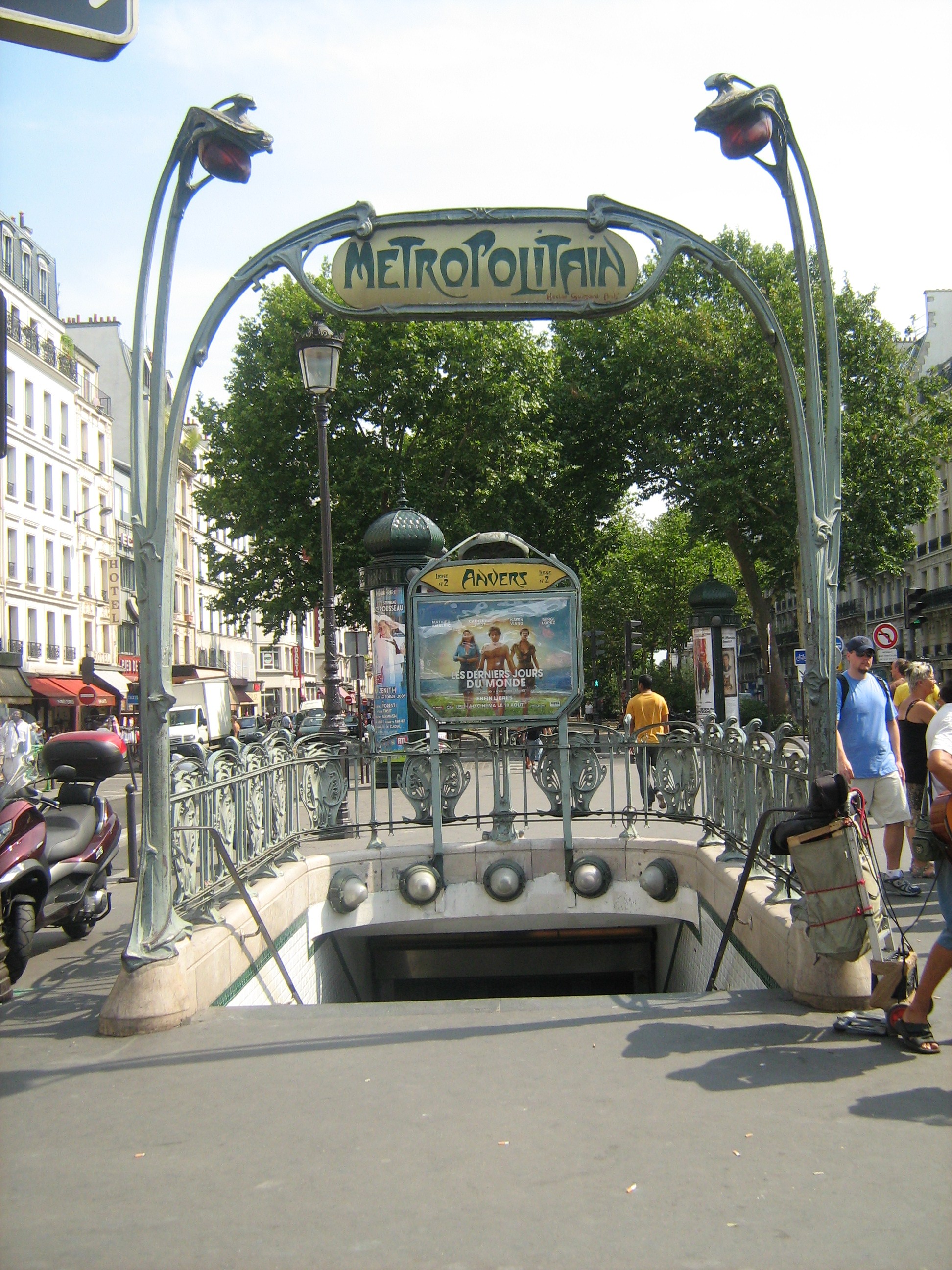
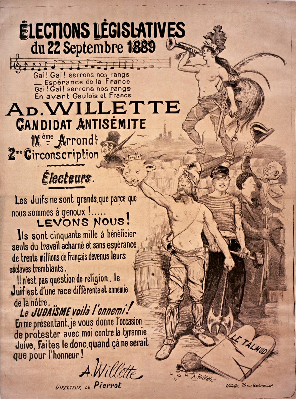
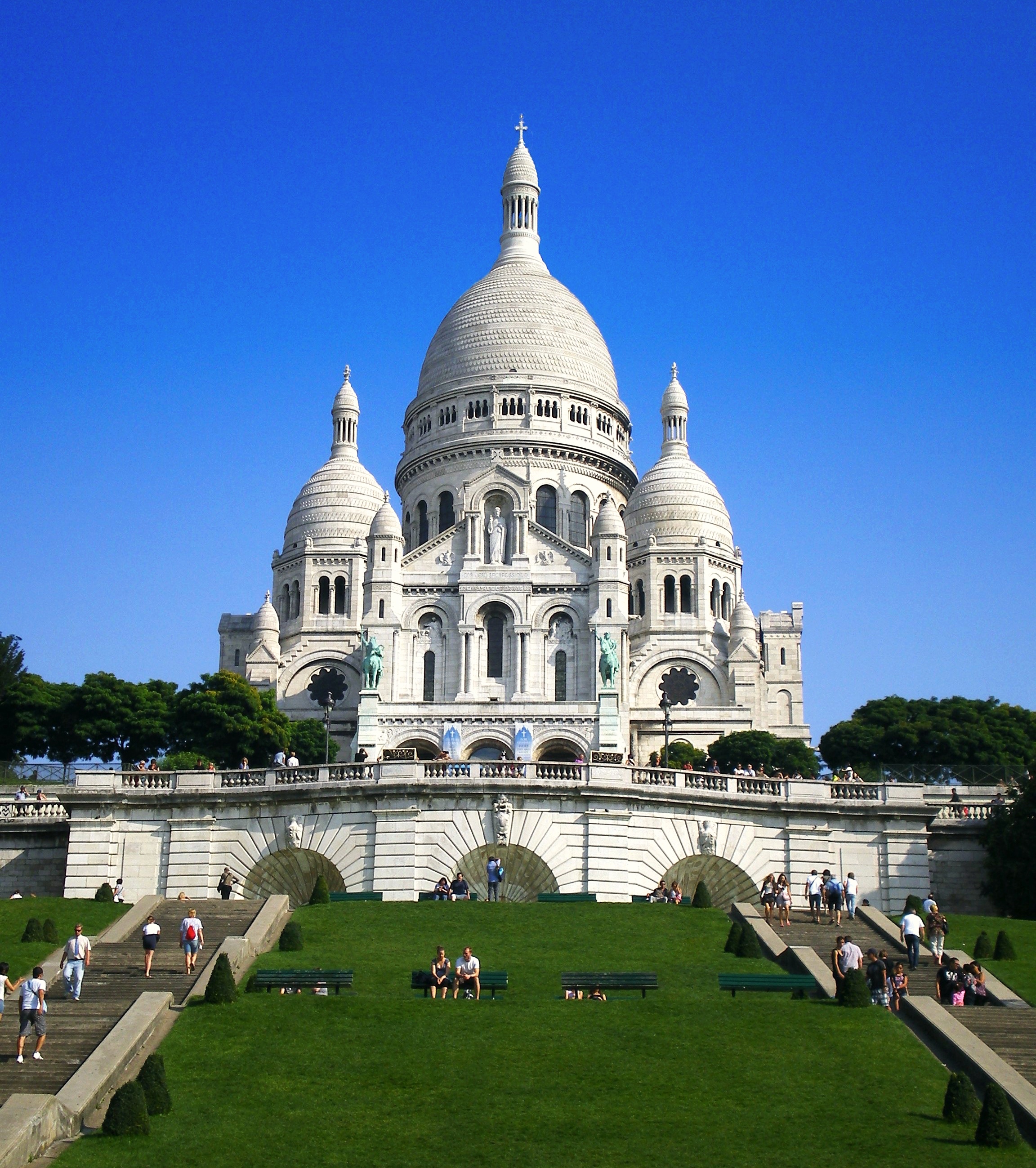
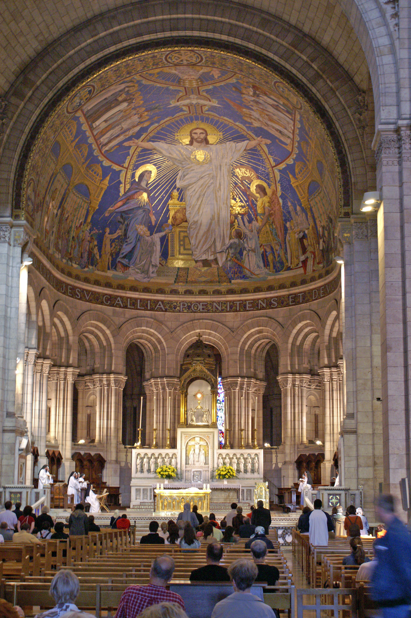
![La Bohème [du Tertre]](https://upload.wikimedia.org/wikipedia/commons/1/15/Sacr%C3%A9-coeur.JPG)
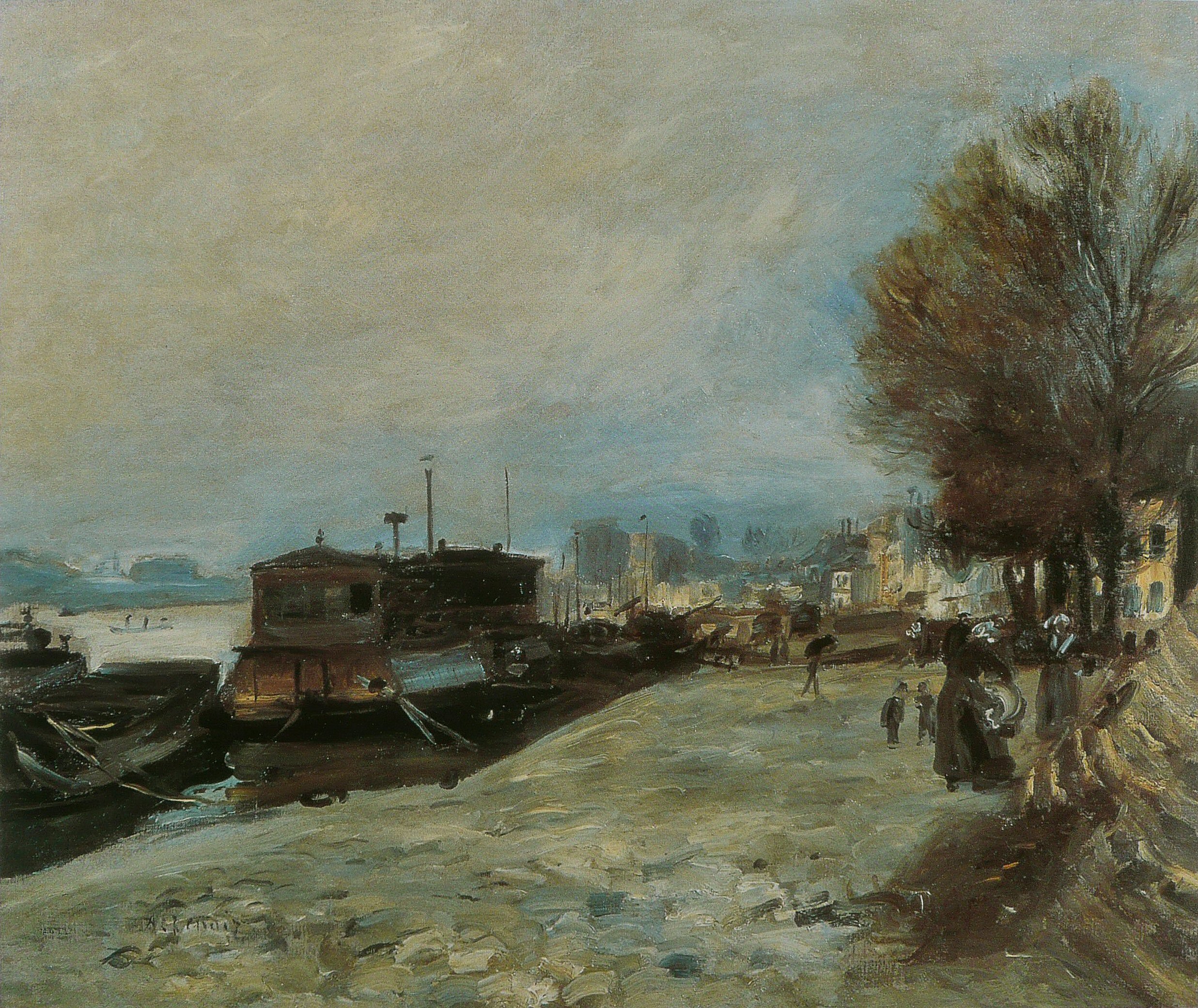
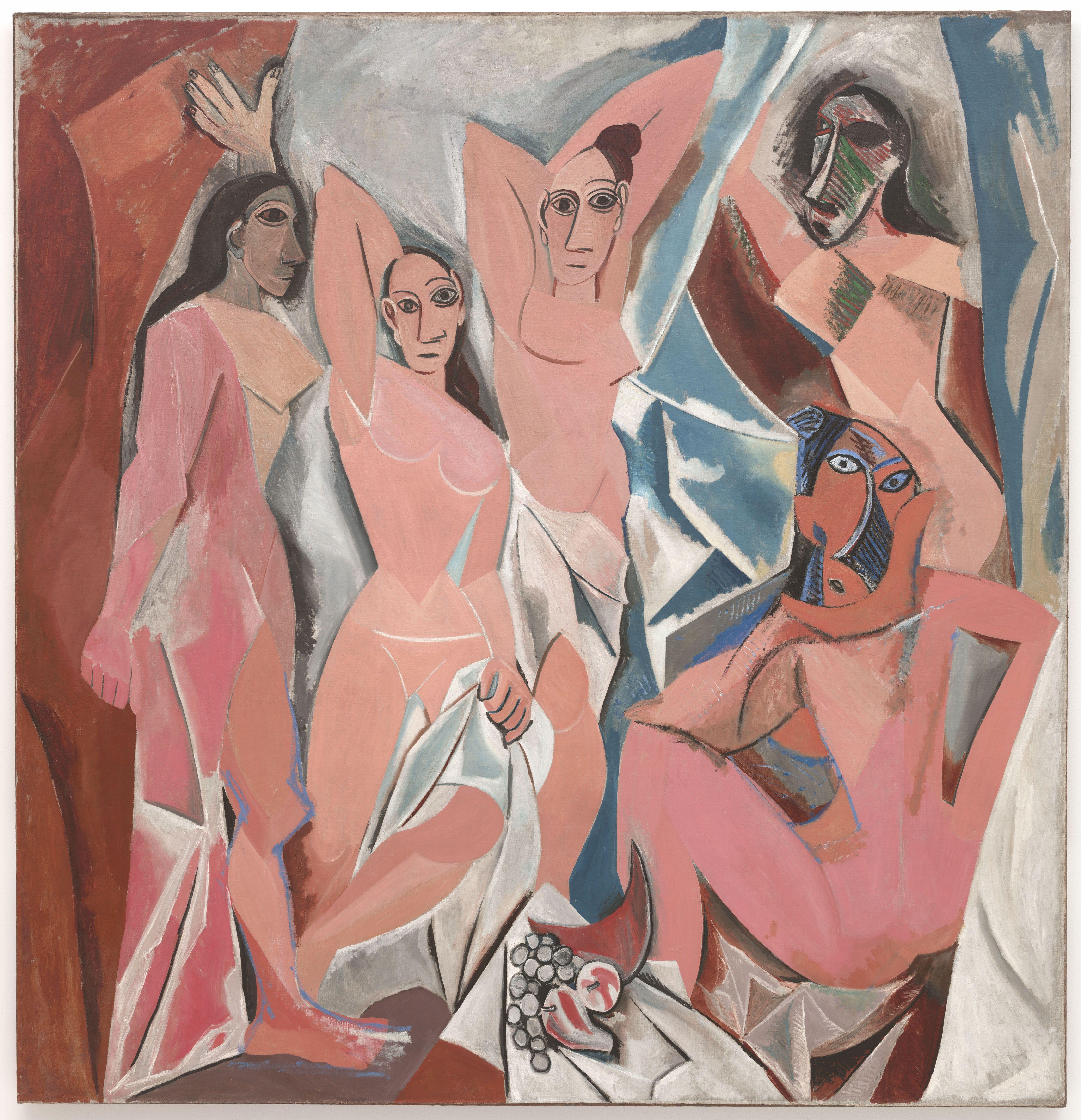
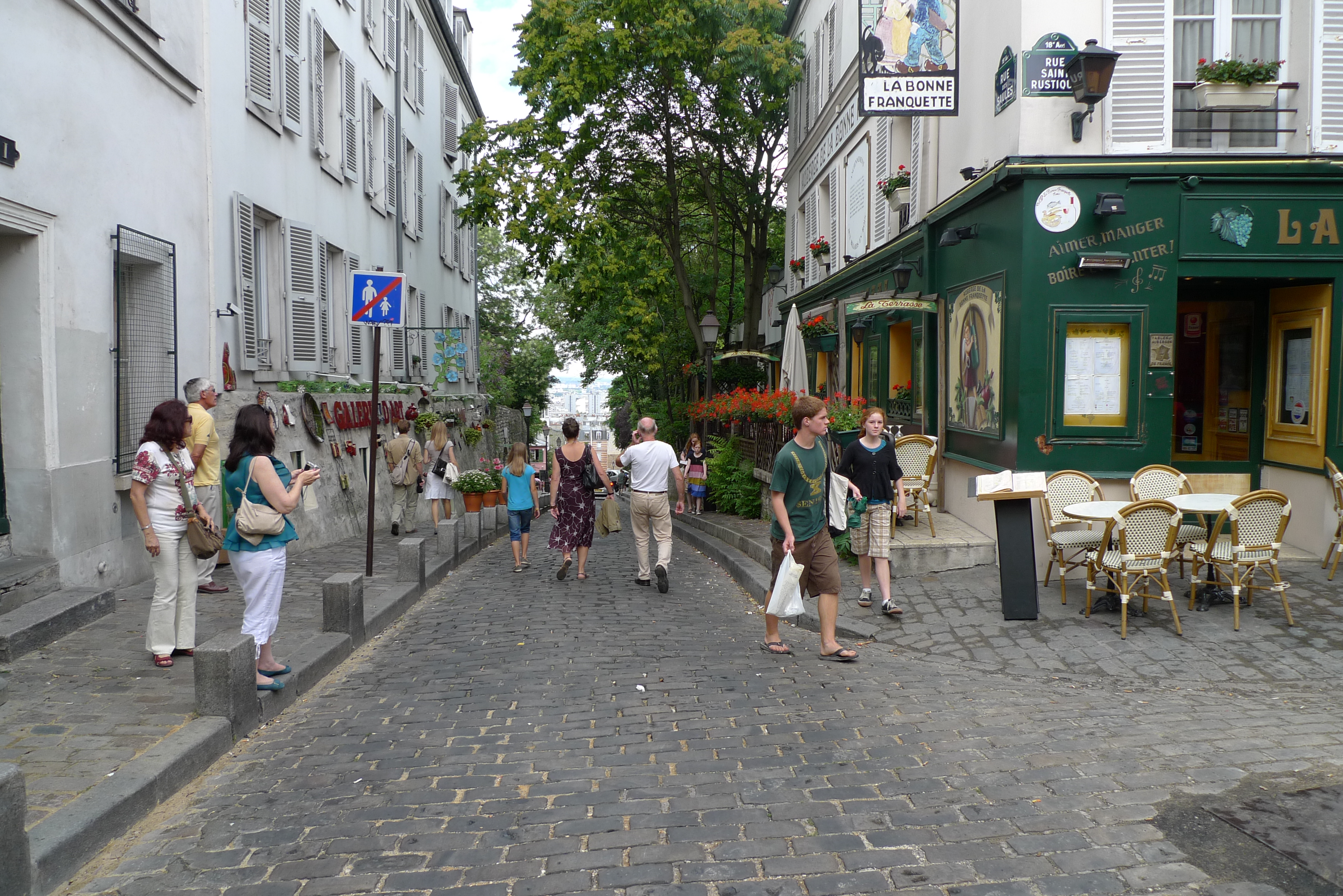
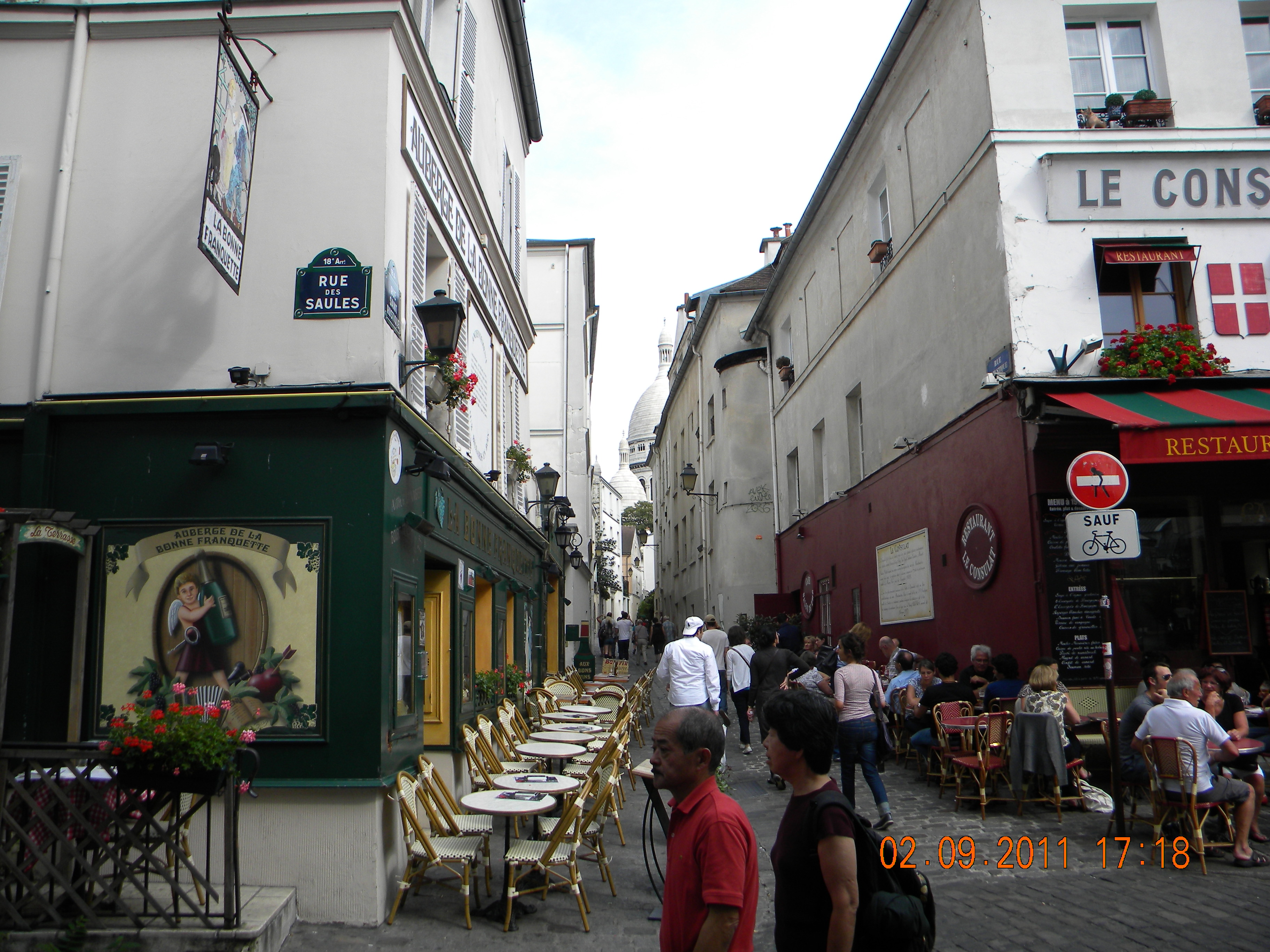
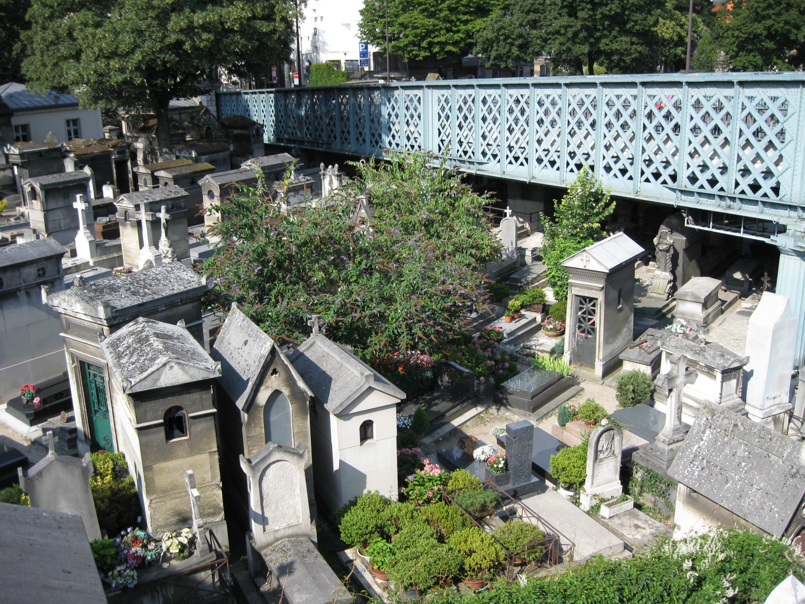
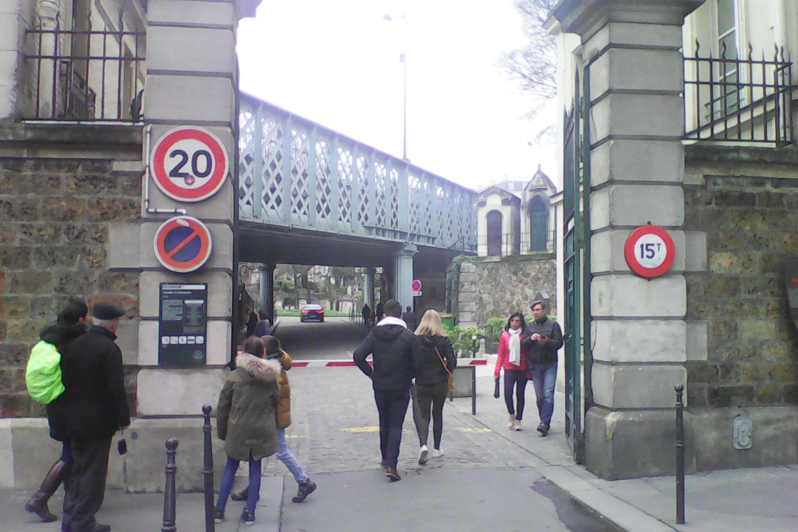
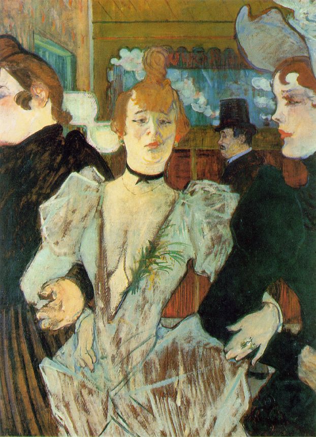
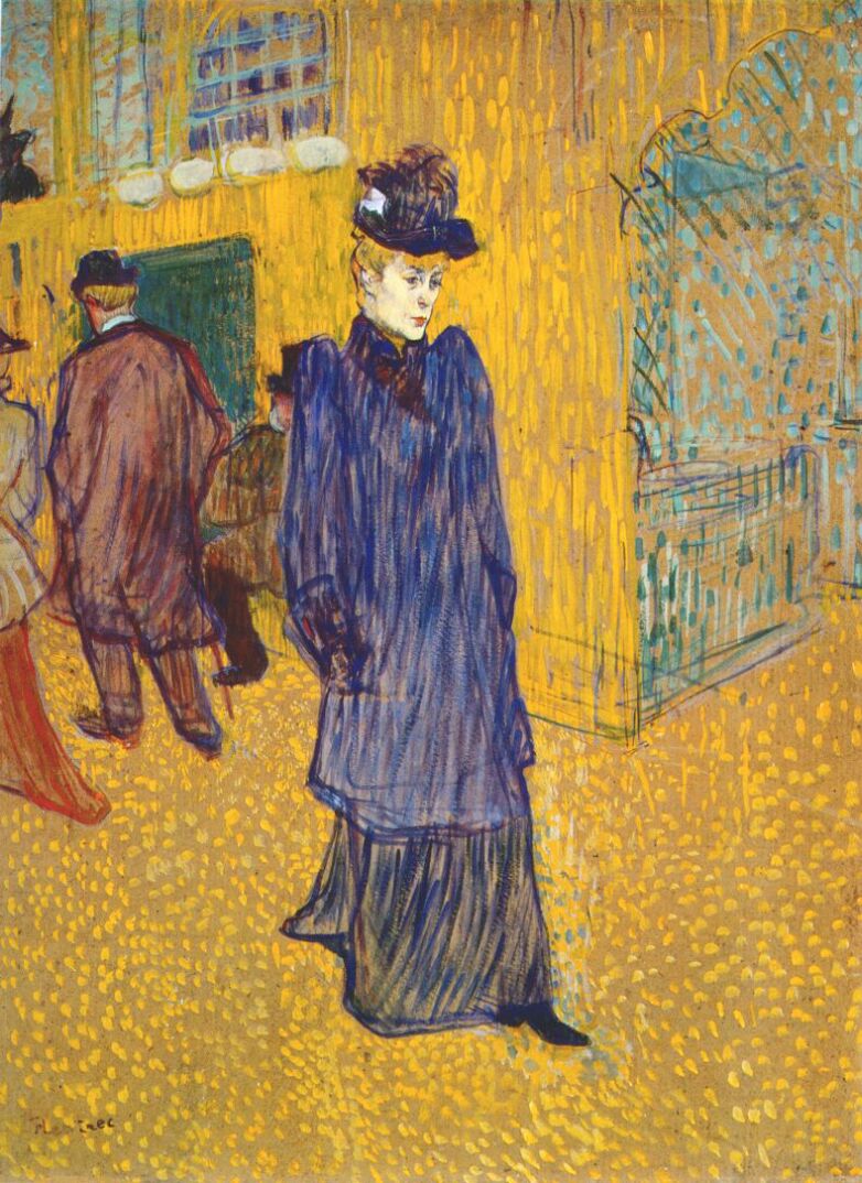
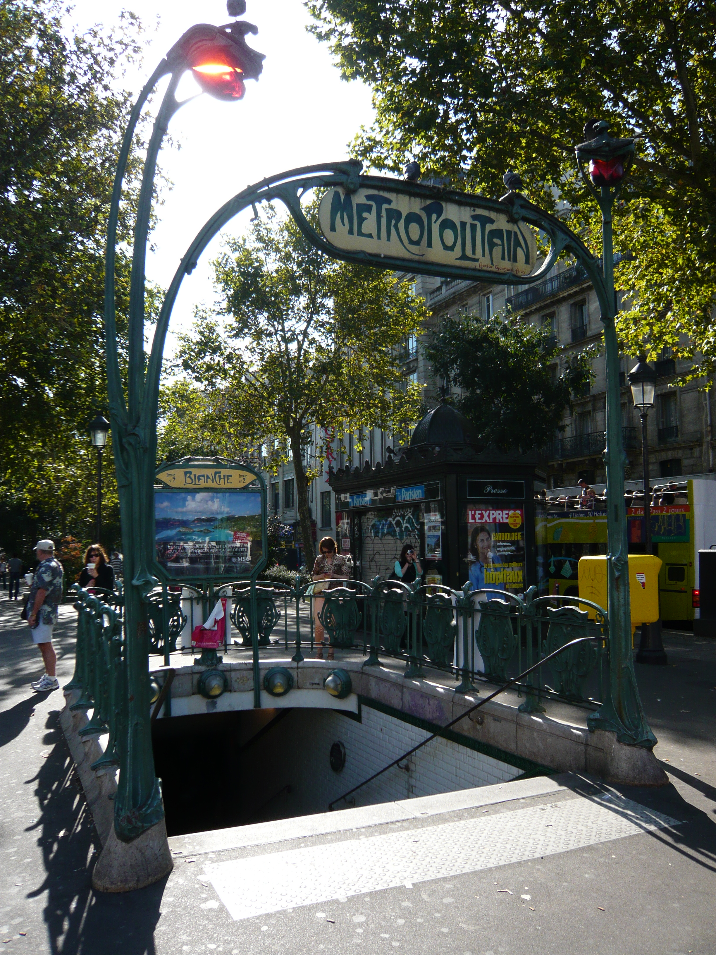