|
Reflections 2012
Series 7
May 31
Atlantic Isles II: Azores: Terceira/Angra - São Miguel/Ponta Delgada
| | Terceira My second island in the Azores was Terceira (ter.SEI.ra, EI as in EIght). Faial has an area of only 43% of Terceira, so this island was roughly twice as big. It’s population is 56,000; that of its capital, Angra, is 21,000.
| | | | The meaning of “Terceira” is easy to explain, and people usually smile when they hear it. It was the third island discovered here, and its name simply means “third”, using the feminine form to agree with “ilha” (IL.ya), island: Ilha Terceira. I saw a panel truck referring to it as “Ilha 3”. By pure coincidence, it’s also third largest in size, so the name really fits. | | | | The capital, Angra, means “cove”, and illustrates the importance of sea transportation over the centuries. We’ll see in Iceland that “vik” in the Scandinavian languages also means “cove”, as it appears in “Reykjavik”. However, Angra has a particular quirk to its name. During a political struggle, a queen added two words to the name in recognition of the perceived bravery and sacrifice of its people, “do Heroismo”, so the entire name, usually seen on directional signs, is Angra do Heroismo (A [NG].gra du e.ru.IZH.mu), which would translate as Heroism Cove.
| | | | This is the map of Terceira. The legend happens to be in Swedish, and means, in order, General Road, One-lane Road, Forest Road. The visit all started at Lajes Airport, at the one o’clock position. It’s pronounced LA.zhesh, and may be familiar for military reasons, since the British built it in 1943, the US expanded it in 1944, and the US Air Force still uses it as a base. I was surprised to find there actually was an expressway to Angra, called a Via Rápida, shown as a straight diagonal on the map. The only negative is that, since roundabouts (traffic circles) are so common here, even the Via Rápida avoids cloverleafs by having traffic slow down at every crossing to use a roundabout. The Via Rápida brought me quickly down to Angra, at six o’clock on the map, actually on the cove to the right of that large promontory, which is Monte Brasil, similar to Horta’s geographic situation. I needed to get to the short road west of Angra leading to São Mateus (ma.TE.oosh, E as in café). It means Saint Matthew because of the huge church in the middle of the town, viewable even from Monte Brasil. The mountain drive I’ll describe later is on that central west-east road, connecting to the Via Rápida.
| | | | Quinta das Mercês I moved up a century. If I had 16C surroundings in the pousada in Horta’s fort, near Angra I had a 17C manor house, the Quinta das Mercês (mer.SESH, E’s as in café). That road I pointed out west of Angra to São Mateus is known for its succession of fine Quintas, a word that needs an explanation. Quinta (KI [NG].ta, I as in SKI) is a Portuguese word that describes a rural property, from simple to elegant. It can be a farm, and most quintas started out that way, including this one, in the 16C, a century before the house. If it grows grapes and bottles wine, it’s referred to as an estate, and Portuguese wines that are estate-bottled will use the word quinta. Some of the simple farmhouses were later replaced with upscale houses, and the word quinta started to refer to them, the manor houses. Eventually, on many quintas, there were no more farms or simple houses, and quinta referred just to a manor house, as in the case of the Quinta das Mercês, which also, typically, has extensive gardens in the front and a forest area out back. | | | | The Via Rápida took me over to the west side of Angra, just what I needed, and I soon came to the Quinta, which is only 1.6 km from town. My first view was of the Enseada das Mercês, or Mercês Bay. This view looks west toward nearby São Mateus, where I’d have dinner both nights, and the stone wall on the right is the lower wall to the Quinta. Since the Quinta’s gardens behind the wall slope upward, from the house and its broad front terrace you don’t see the road but look right into the bay and ocean beyond. (These pictures are all from Wikipedia, but some topics about other countries won’t be in English Wikipedia, extensive as it is. In that case, you delve into Portuguese Wikipédia, which is where these pictures are from.)
| | | | Up the short driveway through the gardens and lower outbuildings you come to the manor house, but that long wall you see is deceiving. The manor house is the red-roofed building on the left. The façade then continues along a wall to the right with a garden behind, then a chapel, then another wall with a garden. Both buildings were erected in the 17C, the house first, the chapel some years later. The buildings had belonged for centuries to a Castro family, but had recently been in ruins, and an older couple took the property over, restored the buildings, and operate the house as a hotel. There are three huge living rooms up front, an old kitchen used for breakfasts, and fewer than a dozen guest rooms in the back. In one of the living rooms are several photos, proudly displayed, of the King and Queen of Spain (that’s Spain, not Portugal) during their visit to the Quinta some years ago. | | | | But it’s that chapel that’s also very interesting. It’s a jewel, and while I was there, a craftsman was repainting details. I watched him as I saw him apply gold leaf to some woodwork, with the excess gold leaf fluttering to the ground. When I came back later, the woodwork gleamed. | | | | You may have become suspicious that it’s the chapel (note the broad terrace on the left, which has the sea view) that gives the Quinta its “merciful” name. The chapel (ermida, as in hermitage) is the Ermida de Nossa Senhora das Mercês, and the FULL name of the Quinta is the Quinta de Nossa Senhora das Mercês, the Manor of our Lady of Mercies. It’s so typical in Mediterranean countries to have very Roman Catholic names for non-religious properties. The short version of the name, Quinta das Mercês, would have to be the Manor House of Mercies, which doesn’t work in English. I’d alter the translation to Mercy Manor, which still sounds a little odd to me. | | | | Furnas do Enxofre Back on Fail, I’d needed just one day to do my outside-of-Horta visiting. Since there was less to see here and since I had a partial day left, I decided to use it to do my mountain drive. I drove through nearby São Mateus and up to the nine o’clock position on the island, and went up the mountain road through the forests. There were frequently handsome stands of massive trees, and views down to the south coast, including Angra. It was on this road where I went along for quite a distance with nothing but hydrangea bushes lined up solidly on each side, although there were fewer blossoms than there could have been, since it wasn’t apparently the season yet. Then I came to my interesting destination in the mountains, the Furnas do Enxofre. | | | | I knew vaguely what I was about to see, but didn’t realize that the Portuguese name actually told the story. X is SH in Portuguese and enxofre is pronounced e [ng].SHO.fre, with both E’s as in café, but the first one nasalized. The word means “sulfur”. Furna is an interesting word, and I didn’t like the translations I saw (as I’ve said, there’s a lot of garbage out there). I saw “cave”, I saw “cavern”. We’re talking about gases coming out of the ground, and “cave” doesn’t cut it in English. If you don’t want to use the scientific word “fumerole”, than I’d use “vent”. Furnas do Enxofre are Sulfur Vents. | | | | The place is more idyllic than the name implies. There was a little pond, and a bog with large ferns. There were flowers, and birds were chirping in the large trees. There was an extensive boardwalk system with side fences, which at times became a dirt path with side fences, to keep people from damaging what they saw--or getting burned. I learned from the large tablets, in English as well as in Portuguese, that this was called “secondary volcanism”, a term I like. If volcanic eruptions are primary, gases and steam coming out of the ground is secondary. I suppose hot springs and geysers would be, too. | | | | There was one place from which steam was actually coming out, but I had to work hard to try and detect the sulfur smell I expected. Maybe it was too windy. But there were plenty of places where crystallized sulfur appeared around the vents, and was yellow in color. I learned that the red color was iron oxide, and white was aluminum oxide. | | | | Apparently these vents occur where several geological faults intersect. The shafts let out volcanic gases and steam at various temperatures, typically 95°C (203°F) on the surface but 130°C (266°F) a half-meter/half-yard below the surface. I was surprised to find out that 95% of what came out was carbon dioxide. 3% was gas containing sulfides, and there were traces of hydrogen, nitrogen, and methane.
| | | | The two pictures I got from Portuguese Wikipédia don’t seem to show any of the yellow sulfur color, but this is what the vents looked like. Click to enlarge this second picture to see the fenced boardwalk/dirt path in the background that leads around the site. | | | | Adega São Mateus Back at the Quinta, it had gotten chilly and windy, and was time to break out the sweater I had with me for Greenland (!!!). The view from the terrace showed white breakers on the blue waters, as I asked my host where he recommended I get a good dinner. He like a good place right over in São Mateus, right across the narrow main road through town from the imposing church. The word “adega” is another example of a word, like quinta, that has climbed up in the world. It means “cellar”, and can be used that way, but then it takes on the convivial connotations of, maybe, a wine cellar as a nice place to be. Now restaurants use the word in their names, even though they’re on the ground floor and have nothing to do with a cellar, as in the Adega São Mateus. (The French word for “cellar”, “cave”, has risen similarly.) It was small and cozy, had azulejo tiles (more below under “azulejo”) halfway up the wall as wainscoting, and there was a nice warm soup as a starter. I went there both nights.
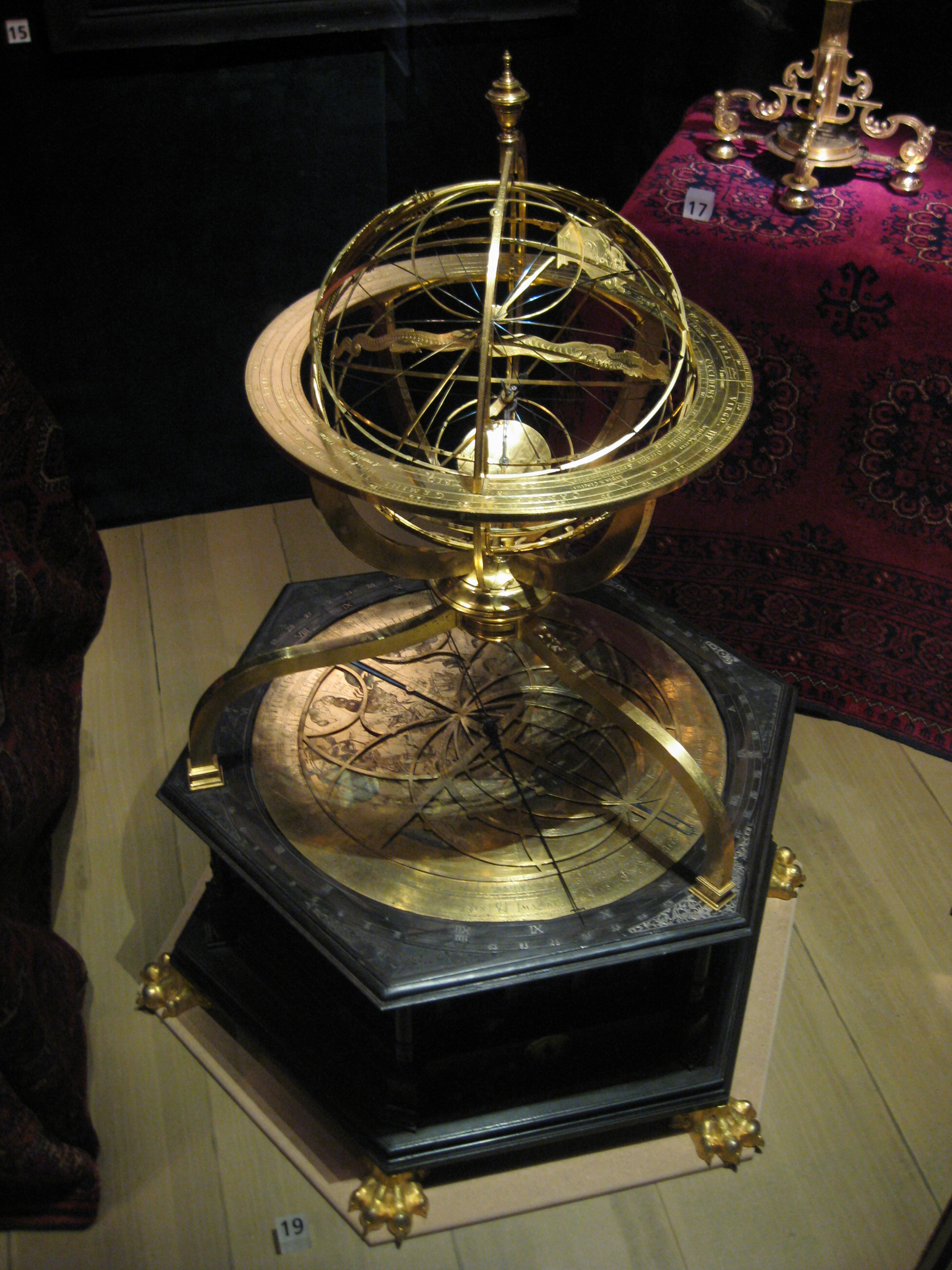
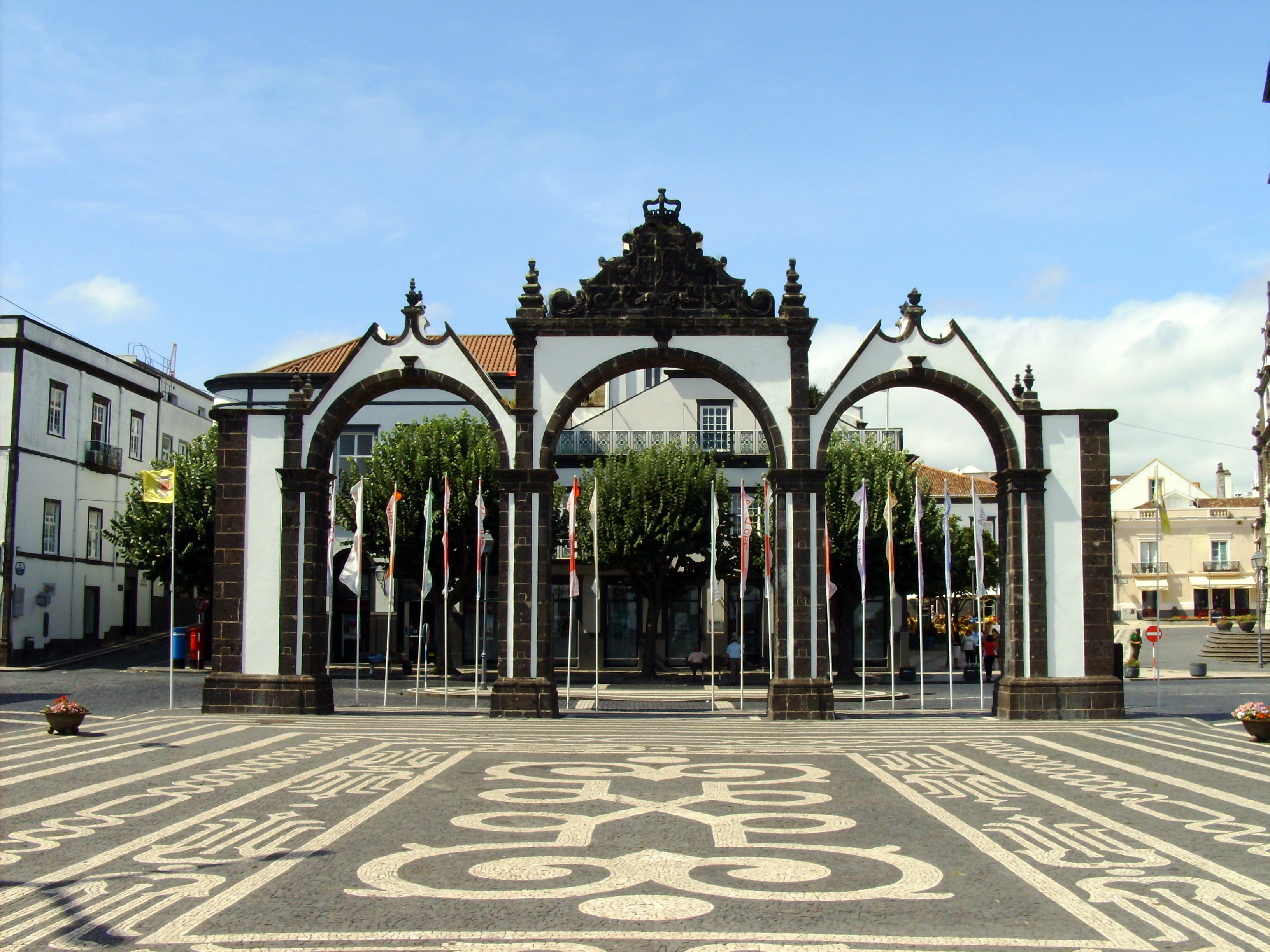
| | | | Angra Angra do Heroísmo is the historical capital of the Azores; it is also the archipelago's oldest city, dating back to 1450, and is classified as a UNESCO World Heritage site. It being an old, charming city with narrow streets, it’s a horror to drive in. For a traveler, a car is a wonderful thing in the countryside. I remember renting a car to drive in the US southwest, including on Route 66. I remember driving up from San Francisco to Seattle and seeing the wonders en route. In town, it’s another thing. Sometimes driving in cities has been useful. I picture driving through London, Paris, Rome, Berlin, to see the big, outlying picture of what’s there. It was especially useful when Beverly was in a wheelchair. But for the most part, a car in town is bad news. And so in Angra. I had rejected a couple of hotels in town because they had no parking, which led me to the wonderful Quinta das Mercês on the edge of town. Now, the next morning, when I tried driving through Angra, what I found was this. The main street went west-east, and was two way, heavy with traffic. The side streets were charming, but narrow. On one side was where cars were parked. On the other side (one way, of course), is where cars drove. The sidewalks would usually barely accommodate one person walking. How do you live with that when you want to experience charm? | | | | At first I avoided the problem by deciding to visit Monte Brasil, that promontory mountain just south of Angra. I finally made my way, with difficulty, through town to the point of access. You first had to drive through ancient gates of the Forte de São João Baptista (you can tell that’s the Fort of Saint John the Baptist, can’t you? So many secular things have religious names, it seems.) You then squiggle up to the top of the hill, passing a deep depression that was clearly a crater, just as in Horta, for a magnificent view over Angra and its cove. | | | | At the top of Monte Brasil, there were two things of interest. One was labeled the Monumento ao V Centenario do Povoamente de Terceira, 1432-1932. Even not knowing that the sixth word meant “population”, you could figure this out, and it gave a great feeling of just how long the Azores have been Portuguese. But as I walked around, I saw some relatively newer artillery than I’m used to seeing, and wondered why they hadn’t been cleared away. Then it struck me: why admire cannons from centuries ago and not 20C artillery, which is history in the making? The installations were under the supervision of the Museu de Angra, and I think you can get the gist of the sign, of which this was the entire text: Bateria de Artilharia Anti-Aerea 9,4 cm Modelo 1940. Origem Britânica. Instalada neste local durante a II Guerra Mundial. | | | | Coming down from the mountain, I’ll admit to getting temporarily lost in a tangle of one-way narrow streets as I entered town, but then I wanted to see Angra. You could pay for street parking, by buying a ticket and displaying it on the dashboard, showing when your time ran out. But what fun is it to meander aimlessly, always with the knowledge of the clock ticking? Would your time run over? In Angra, the solution turned out to be simple. The main road coming in from the Quinta had, at the Angra end, free parking spaces on both sides, and I parked there. Most spaces were empty, since it was about a ten-minute walk into the center of things. That was perfect. Walking is the way to seeing things in a town or city. I learned urban walking years ago largely from the series of books called “Turn Right at the Fountain”, which are still available on Amazon. They had the most wonderful walking tours of big cities in Europe as well as small towns. The walking tours typically would use phrases such as the title, to get you to see the marvels of towns that were laid out for walking in the first place. (I had a nice additional walking experience in Angra which I’ll tell about separately: see “Enrique” below.) | | | | The ten-minute walk into town down the main street, Rua da Sé / Cathedral Street, led me to the Sé. I sat to rest on its stone wall under a tree, and was pleased to hear the hour chime. It wouldn’t have been the same from a car, and from a tour bus--eek!! I had time to admire the colorful wrought-iron balconies many houses showed one flight up. The Sé was built on the site of a 15C church from 1570 to 1618. It’s in an austere style, and has a fine, carved wooden coffered ceiling. Along the nave are gray, square stone columns, connected back-to-front by Romanesque arches. | | | | Michelin advised me to go one block behind the Sé to see the Palácio dos Bettencourt, a 17C town mansion in baroque style. It now houses the city library and archives. In the entry hall there were portraits in blue-and-white azulejo tiles (again, discussed later), and one caught my attention in particular. It illustrated the Chegada (Arrival) de Vasco da Gama a Angra no ano de 1499. Such history! You don’t see this from a tour bus, or even from your own car. Adjoining was the most attractive, petite, library room I can recall. It was all in dark wood, including ancient bookcases, with a row of dark wooden desks on each side. I just had to sit in one of the chairs, which had a (very comfortable) tooled leather seat and backrest. It doesn’t get much better than this. | | | | Three blocks further was the triangular Praça Velha / Old Square (PRA.ssa VEL.ya; Praça = Plaza; Place, Piazza; Platz) in front of the 19C Town Hall, surrounded by historic buildings. There were 6-8 trees around the Praça, and, sitting on a bench, I did a double take. I could tell from the blossoms that they were all faya trees! Studying in advance results in deep pleasures of recognition at the time. | | | | A block north of the Praça was the public garden, the Jardim Público Duque da Terceira, which had nice plantings. I knew the garden meandered up the hill, with an obelisk at the top, but I wasn’t about to start climbing. Well, maybe a bit. A little more--the view is improving. Of course, I huffed and puffed all the way up stone staircases between flowers to the open terrace with the obelisk, and was, of course, deeply rewarded by the view. Even more so, when I realized this was the view I’d found online and put aside for the website over Angra, its bay, and Monte Brasil. First, do appreciate the height I’d climbed as you look down in the left foreground through the Jardim Público into town. Note the two towers of the Sé standing out on Rua da Sé. Beyond that, note the walls of the fortress, completely cutting off access to Monte Brasil, and at top center, you can make out the monument at the viewpoint. | | | | I slowly and leisurely made my way back through Angra, drove back to the Quinta, and to the Adega for dinner, and the next morning, flew from Terceira to Ponta Delgada on São Miguel. But first some topics related to our discussion. | | | | Infante Dom Enrique We have three separate topics stemming from the visit to Angra, and the first is something that only happens when you’re calmly strolling along. Walking into town, just before the Sé, I passed a triangular park across the street that looked inviting for the return walk. But just as I was looking at the park, the doors of the building just beyond the park opened, and four million kids streamed out. Now that I’m more in tune with cartooning, I’d wonder how a cartoonist would picture the hubbub. But I leaned against a lamppost and watched the fun. Shortly, a half-dozen women teachers in long smocks made order from chaos, all were lined up, and proceeded to cross Rua da Sé towards me via the crosswalk. It now looked like ducks leading their young, all in one long row. I don’t know where they were going, but it stopped traffic for a few minutes. I’m sure the waiting drivers weren’t having the fun I was. | | | | Like bookends, this little triangular square surrounded my walk of Angra, because, when I was leaving, I sat down to enjoy the square. I now saw that the building, whose historical marker (I read them all) said it had been a convent, then in the 1820’s a military barracks, was now the Escola Primaria Infante Dom Enrique. I’m sure you can figure out the first two words, although the first is pronounced ish.KO.la. But how about the Infante Dom Enrique? Do we know who he is? (We do.) And why was this particular school named after him? Maybe you can figure it out, or it will occur to you as we talk. | | | | I had always known the word Infante (feminine Infanta) from Spanish, but never quite knew how an Infante fit into a royal family. The answer turns out to be simple. In both Spain and Portugal, the heir to the throne was the only one who got the title of Principe or Princesa. All the other royal kids were Infantes or Infantas. It’s surprisingly simple, but confuses us because to us, they’re all Princes and Princesses. While the word Infante in Spanish is pronounced quite straightforwardly as in.FAN.te, Portuguese nasals come into play, so forget the two N’s, and in Portuguese it’s instead i[ng].FA[NG].te (I as in ski and e as in café). | | | | Dom (DOH [NG]), feminine dona, is the equivalent of Spanish don or doña, as in Don Quixote or Don Juan. It’s a title of respect used with first names. Figure it out yet? | | | | Enrique in Spanish is en.RI.ke, but in Portuguese is e[ng].RIK. It’s of course Henry. Maybe by now you know we’re talking about Prince Henry the Navigator. You can also express his name as the Infante Dom Enrique O Navegador, if you wish. He was the third child of a king, hence an infante, and his dates are 1394 to 1460. He took an early interest in cartography and navigation and became a hugely important figure in the early days of European, particularly Portuguese, exploration. | | | | We’ve discussed the town of Sagres (SA.gresh) near the Cabo São Vicente, the southwesternmost point in Portugal and also Europe. Henry established his own town on the Sagres peninsula called, appropriately, Vila do Infante / The Infante’s Town. The area has access to both the Mediterranean and the Atlantic, since it’s just beyond the Pillars of Hercules at Gibraltar, and Henry sponsored voyages starting there, involving such familiar names as Vasco da Gama and Magellan. As a result, one of his people discovered Madeira in 1420, and at Henry’s instigation, Portuguese settlers colonized it. Then in 1427, one of his navigators discovered the Azores, which was colonized by 1430. Hence the Escola Primaria Infante Dom Enrique, not for the discoverer himself, but for the man behind it all. | | | | We last saw and discussed Henry in 2007/9 when visiting the Belém area of Lisbon, where the Padrão dos Descobrimentos / Monument to the Discoveries is to be found. This is a detail of the front of the monument showing Dom Enrique up front, with some of his many navigators depicted down both sides. But wait. What’s that round thing the fifth man behind Henry is holding? | | | | Armillary Sphere It is difficult to visit Portugal and look at its art and monuments without learning what an armillary sphere is. Either that, or you go home wondering what all those round things are and why they’re there. An armillary sphere (also called an astrolabe) is a navigational instrument with an unduly complicated name. I never knew what exactly “armillary” meant, so I just looked it up. It means “pertaining to rings”, or “made of rings”, so it’s a ring sphere. I’ve got a better idea. Why don’t we just call it a “ring globe” so that everyone can understand what it is? | | | | This is a particularly beautiful example of an armillary sphere / ring globe made in Kassel, Germany, in 1585. It’s museum-quality, and as a matter of fact, it’s now in Nordiska Museet in Stockholm. It’s an astronomical machine composed of rings, all circles of the same sphere, representing the sky, and is used to represent the motion of the stars, from which longitude and latitude can be calculated, making it the prime navigational instrument of its time. Think of it as the GPS of its day. | | | | We last saw a celestial globe (globe of the skies) illustrated by the Farnese Atlas, the sculpture in Naples (2012/4). An armillary sphere differs from a celestial globe, which is a smooth sphere meant to map constellations, in that it can be considered a skeleton celestial globe. | | | | This is a detail of the above detail, showing mathematician and navigator Pedro Nunes holding an armillary sphere, to indicate its importance to navigation of the period. | | | | The imagery of the armillary sphere is essential to the Portuguese sense of history, and is a national symbol. Take a look at the Portuguese flag, which includes the national coat of arms, consisting of a shield--and an armillary sphere. The armillary sphere represents discovery and expansion, and is directly parallel to the Pillars of Hercules and motto “Plus Ultra” on the Spanish flag, which represent the same thing (2012/4). | | | | Azulejos I’d said above that the lower part of the walls at the Adega I had dinner in was covered with azulejos. I also mentioned an azulejo picture of the arrival of Vasco da Gama. These are ceramic tiles, almost always blue-on-white, that are essential to Spanish and Portuguese art and architecture. In Spain the word is pronounced a.thu.LE.kho (TH as in THin), and in Portugal it’s a.zu.LE.zhu. The azulejo has been essential to Spanish and Portuguese culture for five centuries. Azulejos decorate the insides and outsides of homes, churches, palaces, and are found almost everywhere. | | | | These tiles are of Arabic origin, brought to Iberia by the Moors, which explains why some of the simple tiles are geometric or floral. Their manufacture was established in Seville in the 15C, and in 1503, when Portuguese king Manuel I visited Seville, he was so impressed that he arranged their import to Portugal. Some of the oldest azulejos are to be seen in the Sintra Palace near Lisbon, and what do we see? Repeated images of armillary spheres! | | | | A street scene shows a sign panel in azulejos. This is a picture made of azulejos. And finally, to tie two themes together, this is a panel showing Prince Henry at Sagres. Note, as a change, the gold color tiles at the top, and find Henry dramatically contemplating the sea on the Sagres promontory. | | | | São Miguel My final stop in the Azores was Ponta Delgada, on São Miguel. Terceira, third largest of the Azores (Faial was fifth), is 53% of the area of São Miguel, largest of the Azores, so I’ll again roughly have doubled in size the area of the island I’m visiting. | | | | The meaning of São Miguel should be obvious as Saint Michael. Ponta, on the other hand, means “point” as in a point of land, so Ponta Delgada is Slender Point. But I didn’t see any obvious point that this could be referring to. | | | | I don’t have a map of São Miguel, but it’s easy to visualize its shape. Picture not a hot dog, but a fat bratwurst lying on its side, and that’s the shape of the island. There are three obvious sections. 1) The left quarter of the island is filled by the huge volcano known as Sete Cidades. 2) The next quarter is a low area, with Ponta Delgada on the south shore. 3) The right half of the island is mountainous, with a) the lake, Lagoa do Fogo, and its mountains filling the third quarter, and b) the mountains around Furnas filling the fourth quarter. | | | | Ponta Delgada I really wanted to be in town this time, and I’d found a nice, historic hotel that was, and it said it had parking. When I mentioned this to the car agent, he commented drily that the parking they have is in their cellar, and there’s a small car lift that brings you down. He said that he’d found that most clients were uncomfortable with that, so I began to wonder. | | | | While I was talking to him, I mentioned I’d be driving to Sete Cidades the next day, and the client next to me, an American woman, commented eagerly that she was from there, and would be going there directly from the airport. I noted her eagerness and excitement as what seemed to me to be another example of someone from the Azorean diaspora “going home”. | | | | The airport is right on the western edge of town, only about 8-10 minutes away, and the signs to the center led me to streets that got narrower and narrower--and one-way. I followed the turns that the hotel website had indicated I should take. I must say that, given the number of small, narrow streets, planners really have done a good job of getting this one-way street eastward, another one-way street a block north westward, and the ones in the side streets in between alternatively one-way. It really does work, despite the hemmed-in feeling. | | | | Reaching my narrow side street from the narrow main street involved a left turn, and my inexperience in tiny towns led me to ride over the curb at the corner. The side street once again consisted of one lane on the left, a row of parked cars on the right, and sidewalks on either side to narrow to be easily managed, so people often walked in the open car lane. Two left turns got me to the next street over and in front of the Hotel do Colégio. | | | | What luck. As it turned out, in the narrow street, with pay parking, there was just one yellow-bordered parking space right at the hotel door, with a sign saying it was for the hotel only. And I got it. When I spoke to the attentive concierge, he took me downstairs to the cellar, where there were about a half-dozen cars parked, and he showed me the car lift. He said if I needed to park there, I should just drive to the side of the hotel and any hotel employee would guide me in, and out. But I never needed to. The second day, coming back from the mountains, “my” street space was again available, and my third day I didn’t use the car, so I had perfect, free parking for my whole stay, right in the center of town. This was especially good, since I had an early flight on the last day, and it made a quick getaway possible. | | | | This third historic hotel moved me up into the 19C. The building had for many years been the site of a prestigious private school, which had moved to larger quarters. A school of classical music had moved in for some years, and then it became a hotel. It had the charm of a traditional right-on-the-street town house, and the educational and music theme had been maintained in the interior. | | | | The hotel restaurant was perhaps the best so far. I got to know the maitre d’, Sário, and he advised me on some good Pico wines. I joked with him that, although I don’t eat too much fish, I knew “it was illegal to leave Portugal” without trying some bacalhau / cod, the national dish, and he advised me on which to choose. The last night he treated me to a local apéritif before dinner. | | | | I still had a half-day left on that arrival day, perfect to walk around Ponta Delgada--and to revel in being right in town. It was just two blocks to where three squares merge just north of the harbor, not far from a rather large fort. This is the Câmara Municipal / City Hall, with its long reflecting pool. Looking in the opposite direction, you might be able to envision that the Cathedral Square to the left behind the trees faces a third square to the right that includes these symbolic Portas da Cidade / Gates to the City, with the Cathedral Square in the right background.
| | | | Sete Cidades In Portuguese, final -e, also in -es, is a dying breed. It’s just what happened in French centuries ago. In French, it’s been a long time since words in a phrase like “une belle ville” were two syllables each. That final E disappeared in most situations, and the phrase is pronounced today ÜN BEL VIL. The Norman French brought to England, along with a lot of French words, that way of writing an E at the end of words that “wasn’t really there”, the so-called “silent E”, as in “bridge, house, are”. | | | | This is now occurring in Portuguese. When I said Açores was pronounced a.SSOR.ish or even as a.SSORSH, the first was only in careful speech; the second is more common. The name Sete Cidades (“Seven Cities”) shows this even better. You most frequently hear set si.DADSH, with those E’s disappearing. It seems to be the route the language is taking.
| | | | But why should a volcano, its crater, the lake(s) and town in the crater, all be called “Seven Cities”? The reason is vague, and involves a mistranslation (what else is new?), but starts with ancient Mediterranean myths of lost islands. (Of course, given the difficulties of pre-armillary sphere navigation, it’s no wonder captains sometimes couldn’t find again obscure islands they’d once visited, and declared them lost.) But we’re talking myths here. Think of mythological islands such as Atlantis, or Antillia, as it even appeared on Columbus’s map. There was an island known in Latin as Insula Septem Civitatem, probably incorporating older Mediterranean traditions. The name means Island of the Seven Peoples (or Tribes). Even though Latin “civitas” is the source of such words as “civic”, referring to cities, at the time it didn’t mean city. In other words, it referred to people themselves, not the place people lived. But in time, the meaning shifted to “cities” nevertheless.
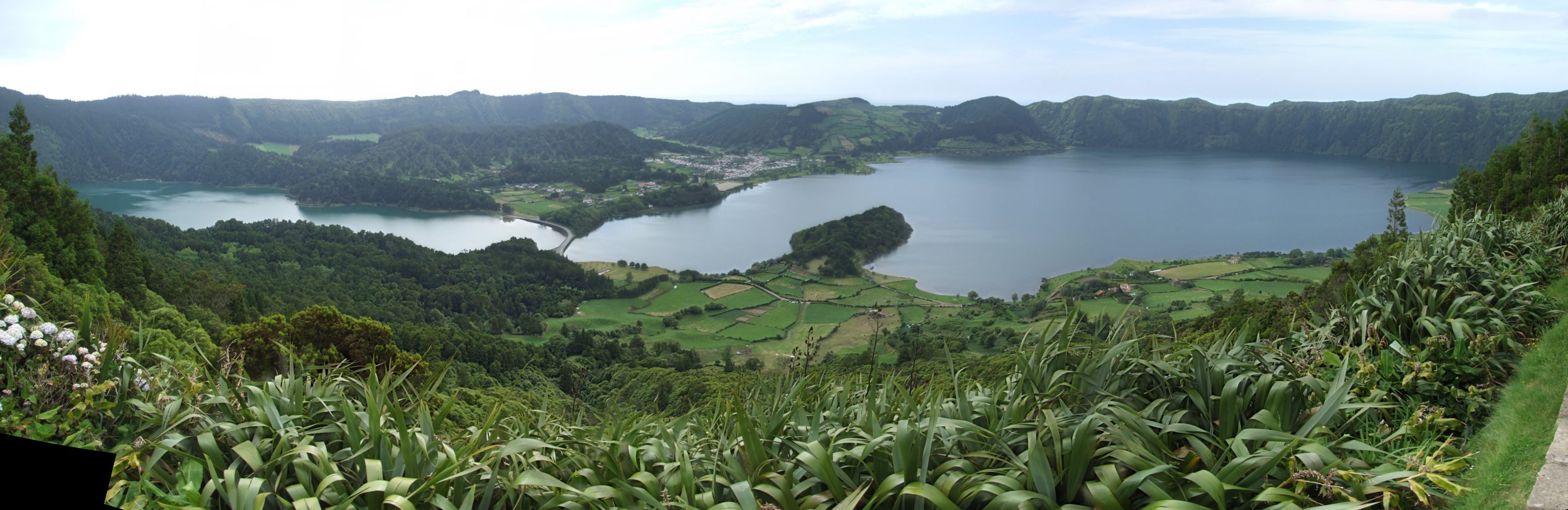
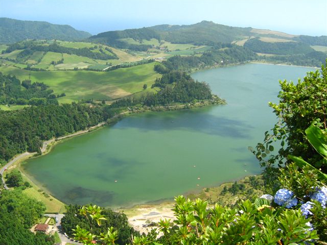
| | | | There is no proof that any Island of Seven Cities ever existed, but somehow, legends developed that São Miguel was it, and somehow beyond that, that the volcano, and everything to do with it at the west end of the island was the legendary place in question. | | | | Flying in to the island, since I knew it was there, I looked for it, and it was clear from the air that the whole rounded west end of the island, just west of Ponta Delgada and its lowland, was one big volcano, with an open crater at the top, and a lake (referred to as two lakes) inside. On the second day, which I’d put aside as my “mountain day”, since Sete Cidades was closest, I started there, and I was on the rim within a half-hour. | | | | Michelin gives Sete Cidades three stars, and they’re certainly right. Elsewhere, it’s described as the natural wonder of the Azores. The crater was formed in 1440 when an eruption completely changed the land at the west end of the island, resulting in a caldera/crater with a circumference of 12 km (7 mi). Pictures usually only show the lake(s), but what you see from the rim is actually this. In the center of the crater is the village of Sete Cidades. The western half of the crater beyond the village is bucolic farmland. The eastern half of the crater is one lake that is perceived as two. | | | | The absolutely best place to view the scene is a point on the southern end of the rim, which is where everyone heads first. The view is so perfect, that it’s called Vista do Rei, the King’s View. You park your car among hydrangeas, other flowers, cedar trees, holly, and heather. My first view was OUTSIDE the crater, back down to Ponta Delgada, 580 m (1903 ft) below. Across the road is this view, into the crater of Sete Cidades. | | | | The village is at the center, with the half of the crater that’s farmland on the left not being shown. The sudden drop of the rim walls can be seen across the way, and where we were standing was the same. You can see that it’s really one lake, the Lagoa das Sete Cidades (using Lagoa /Lagoon, rather than Lago / Lake, seems common for some reason), with two lobes, but they’re referred to as two lakes. The far (north) lake is called the Lagoa Azul / Blue Lake, because of its clarity, but the near (south) lake is called the Lagoa Verde / Green Lake, because of is algae content. The difference is clearly visible in real life, but difficult to see in these pictures. The wasp waist of the lake is cut by a causeway, referred to as a bridge, but that apparently doesn’t have much to do with the coloration. | | | | The lakes have a maximum depth of 19 m (62 ft) and are 251 m (823 ft) above sea level, which makes the view downward from the rim 329 m (1,080 ft). I read on the explanatory tablet that in 1937 they built an outlet tunnel to the sea (túnel de descarga para o mar) just north of the village, apparently to avoid flooding the village. | | | | One then drives downward on the east side of the crater, with several viewpoints, such as this. The view is now westward, and the village is straight across. See if you can perceive more greenness in the lake on the left. There is a stop at the “bridge”, the stone causeway with, of course, seven arches. The sign there with the name of the bridge is in azulejos. It’s very quiet, except for the ducks quacking nearby.
| | | | I crossed over and went through the village. Instead of backtracking, I was one of the few who chose to continue to drive west, through the farmland--cows were mooing--and leave by the west exit, which brought me directly down to the west end of the island, which also had pleasant views. | | | | Eastern Mountains I was soon back encircling Ponta Delgada and moving toward the eastern mountains. Apparently the lowland Ponta Delgada is in was formed by volcanic ash over time, which connected Sete Cidades with these highlands. The sequence of locations in these mountains is Lagoa do Fogo, Furnas, and the east end of the island. Fortunately there are now Vias Rápidas on both the north and south shores.
| | | | I started by driving up to the Lagoa do Fogo / Lagoon of Fire, a crater lake caused by a 16c eruption, not realizing how high up it was, since it’s the highest lake on the island. There were good views, both of the lake and of Sete Cidades in the distance. | | | | Although the interesting city of Furnas is next to the east, I decided for now to just look down on it from the northern mountains, and headed for the viewpoint at the Pico do Ferro / Iron Mountain. It’s at 570 m (1870 ft), and looks down from the north on the vast volcanic crater of the Vale das Furnas, with the Lagoa das Furnas on the right. Since Furnas is at 109 m (358 ft), the view down covers 461 m (1512 ft). This picture, however, doesn’t begin to do the view justice, which wasn’t as good as Sete Cidades, but had more life than this. Furnas here has farmlands in front of it, and you only see a bit of the Lagoa das Furnas on the right. There was an extra plus, though. The viewpoint had maybe 30-40 azalea bushes, and each was trimmed into rectangular shapes to perfection. The view therefore was almost framed in red when I saw it. | | | | It wasn’t far to the eastern end of the island, where there were two viewpoints on points of land looking down the high cliffs to the ocean breaking below. Each viewpoint had more flowers than you could imagine, and one had a gardener tending them while I was there. Both viewpoints also had very alluring names, given that we were at the end of the island. One was called Ponta da Madrugada / Point of Dawn, and the other Ponta do Sossego / Point of Silence. | | | | There was one last poignant point I discovered there. I was reading a tablet at one viewpoint (never let a sign go by!), which had a poem in Portuguese about the area. I didn’t understand much, but the bio down below I found very interesting, and could work through the Portuguese. It mentioned the poet’s name, the fact that he was born in Fall River, but had lived in the neighboring town here from 1910 to 1930 before going home again. Does any of that data strike you as odd? I’ve been a couple of times to Fall River, Massachusetts, near the Rhode Island border, both times to eat in one of the Portuguese restaurants there. Yet here, on this sign far from anywhere, it mentioned Fall River so casually so as to indicate that everyone (local) who heard the name of this relatively small Massachusetts city would recognize it, very likely having friends or family there as part of the Azorean diaspora.
| | | | Furnas Furnas was the high point of interest of these eastern mountains, and the name says it all. We said a furna was, not so much a cave or cavern, but a vent from which we’d seen steam and gases coming up out of the ground. Well, you can see where Furnas got its name. However, because there are several thousand people living within and around its caldera, Furnas is considered one of the most dangerous volcanic areas in the Azores. The first known eruption was in 1440, just after early settlers arrived, and the latest one in 1630, causing 200 fatalities. The area is still considered very active.
| | | | In the town park there are 19C spa facilities for hydrotherapy, but of particular interest are all the hot springs. As I approached the village coming now from the south, I was fortunately in the right part of town for the hot springs, of which I understand Furnas has some thirty, of differing temperatures and chemical compositions. I parked next to a fenced-in area and walked from one hot spring to another. In Portuguese, you seem to use the word “caldeira” not only for a volcanic caldera or crater, but for a hot spring as well, which I suppose is a crater in its own way. The very first one I walked up to offered me a spectacular beginning, as it was called Caldeira Grande, which was a good name for it. To keep the water in a pool, rock frameworks have been built around most springs, but in some, like the Caldeira Grande, in the middle of the hot pool was boiling water like I’ve never seen before. Click to enlarge, and you’ll see not only that this is really a picture of the Caldeira Grande that I found, but the sign is written on azulejos. There was not only steam, but the smell of sulfur.
| | | | Some springs had just steam, often a lot of steam. Some were labeled “Caldeira Seca”, a dry spring. This is another boiling hot spring. Note the red iron-rich runoff at the top from left to right. A nearby stream collected the cooling, often red, runoffs, also shown here. Watch this one on YouTube boil away. | | | | Leaving Furnas, I finally passed the Lagoa das Furnas that I’d seen so clearly along with the town from the Pico do Ferro above both. Note that at the northern end of the lake, in the bottom of this picture (with hydrangeas!), is the other location of hot springs in Furnas, and I made my final stop here. The difference that particularly pleased me here was that there was a little ridge at the edge of the lake, and steam was rising from the side of this ridge facing the lake. If you stepped away in any direction, it looked like the steam was rising from the lake itself. Please note this point, because when in Iceland later, I’ll point out that this sort of situation is exactly how Reykjavik got its name. | | | | That was the end of my “mountain day”, and I spent my third and last day in Ponta Delgada relaxing and writing. I got my early start the next day for Madeira, and was surprised that I learned something new even on the plane. When they served tea and coffee, the flight attendant with the tea came before the one with coffee, and I joked with him about it and asked if the tea was really so good as to come first. He then explained to me the importance of tea in São Miguel, and so I took some, which happened to be (excellent) green tea. Afterwards I looked it up. Apparently, tea growing in Portugal takes place in São Miguel, and Portugal was the first to introduce the practice of drinking tea to Europe. It was also the first European country to produce tea, starting in 1750. Then Portugal’s colony of Macau had an effect, since skilled tea workers came from Macau to the Azores in 1883, and production became significant, and the culture of tea drinking expanded even further.
| | | |
| |
|
|
|

