|
Reflections 2018
Series 6
July 18
Paris IV: The Métro – Petit Déjeuner - Quartier Latin -Tramway
| | The Métro There are many ways to see a city. Best is on foot, since you learn and see so much more. While I don't hike in the countryside, I'm an inveterate "urban walker", as our route yesterday through Passy showed. Actually, a car can be quite an asset in a city. I remember having to have a rental car in the 2003 visit because of Beverly's wheelchair, and being able to take large sweeps around the city, particularly along some of the Grands Boulevards. You can't do that without a car.
| | | | But mostly moving larger distances around a city is best done by rail (I can't recall ever taking a city bus in Europe). In Paris I used the RER for the first time this trip, I used the newly built streetcar line for the first time, I used the newly updated Funiculaire de Montmartre for the first time, and as ever, I rode the Métro. While the basis for the RER is mid-19C rail, altered in the mid-20C to RER, the first line of the Paris Métro was built in 1900, and it's been growing ever since. We've talked about clipped words ending in –O, like photo for photograph; this is a perfect example, since the Metropolitan Railway was the Chemin de Fer Métropolitain, clipped to Métro. While there are many ways to refer to ones in other cities, such as U-Bahn, Underground, Subway, the French word has spread considerably, such as the Metro de Madrid. Moscow and St Petersburg also each have their Метро. | | | | The Traditional Métro I've known the Paris Métro for six decades, since my very first trip in 1957, and it's changed considerably. I knew a quaint little system then, which has now developed into a sleek, modern, highly technological one. Let's first talk about the traditional Métro as I remember it. I've found online a 1939 Métro map that looks very much like the system I used in 1957 and thereafter. Click to check out all the lines and how they rarely leave the city limits of Paris, unlike today. Note two small loops, the red one on line 10 in the southwest, and the purple one on line 7 in the northeast. We'll have more to say about those two later. In the south, note the rail route leading to the dead-end Gare du Luxembourg. Today this extends north as RER B to the CDG airport—the next stop north of Luxembourg is where we got off yesterday to get the RER C. Times change, but this is the Métro I remember from the past.
http://media.gettyimages.com/photos/paris-a-ticket-puncher-punching-the-ticket-of-a-woman-a-person-had-to-picture-id104403718?s=612x612
| | | | I want to discuss and illustrate three major changes I've recognized over time—all for the better. The traditional Métro had both agents selling tickets and 1) poinçonneurs (ticket-punchers) cancelling your ticket on entry (above). I remember them frequently sitting on bar stools at the entry as they punched away. They were replaced between 1969 and 1973. Today, single tickets, and a discounted carnet de dix (packet of ten) are still sold, but by vending machines, though I would be using my five-day 3-zone Paris Visite pass, as seen below:
https://www.meusroteirosdeviagem.com/wp-content/uploads/2015/10/Paris-0096.jpg
| | | | An agent is still available for problems, which came up twice for me. But the second employee, the ticket puncher, is long gone. Today you put your ticket into a slot on the turnstile (Photo by Tangopaso), it sucks it in (click) with a whoosh and spits it out of another slot as you are let through. | | | | The two other things that are now gone were unique to the Paris Métro—and I've been on a lot of subways around the world. One of these were 2) first-class cars, hard as that may be to picture. Trains were five cars long. The first two and last two were green, indicating regular coaches. In the middle was a red first-class coach. It was not an honor system. First-class tickets of course cost more, and if an inspector caught someone in first class with the wrong ticket, there would be a heavy fine to pay. The reasons given for this service were that a middle car was safer in an accident, it had padded seats (but second class also got those post-war), it was available for the disabled and the pregnant. First-class was finally discontinued in 1982 for economic reasons, since it was realized that tickets for it represented a low percentage of all sold, especially given that each first-class coach took up 20% of every train. Here is first-class in action back in the day (Photo by Gonioul). If you didn't know the color code, the big number 1 clued you in. | | | | The other thing unique to Paris is something that seems absolutely counterintuitive: 3) a portillon automatique (automatic gate) stopping you from entering the platform as the train arrives. (!!) They were the bane of all Métro riders, and an example of Big Brother telling you, as an mature adult, just when it was or was not too late to enter the platform so that you wouldn't slip and fall in your haste to catch your train. That loud hiss of compressed air starting to close the gate was the warning sign of doom. Of course, they always closed FAR to early, as the arriving train itself still in the tunnel hit a lever that would start them operating. As you arrived at the platform, you would normally breathe a sigh of relief when you'd made it through the gates. It was one small victory, as they hadn't caught you, and you could make your train. | | | | My present research tells me that they were put in service in the 1920s as—in my words—an overly cautious safety device, so that people wouldn't run to an arriving train. I see that there were two models. The original one was worked by an arm, which helpful travelers could easily block to wait for slower friends. In the newer model, the arm was built into the massive door as shown in these two portillons automatiques (Photo by Greenski). The ominous orange sign (click) warned that "It's forbidden to delay its functioning. Don't try to go through when it's closing". And there's the arriving train just ahead! Starting in the 1960s it was decided they were no longer needed and they were gradually removed. I noticed that nowadays, there's nothing more than a sign warning that it's dangerous to run onto the platform. Good riddance! | | | | I've found a video with beautiful example of everything we've just talked about. It was NOT from YouTube. I mentioned recently that I've been getting a lot of still photos from www.bing.com, and this video is from Bing as well—it isn't even on YouTube. It's a chase scene (2:36) from the 1963 movie "Charade", which I clearly remember seeing at Radio City Music Hall (when they still showed films). Cary Grant is chasing Audrey Hepburn on the Métro in Paris. Take a look first at this scene from "Charade", and then we'll discuss it—twice. | | | | First the three items we discussed. Note at the beginning the fussing with tickets, not only buying them but having them ● 0:17 & 0:22 punched; 0:34 she manages to get through the ● portillon automatique; 0:53 she keeps watching the gate, as she knows it closes when the train pulls in, and is counting on it; 1:16 he pushes through the gate, something I never saw anyone actually do. Back at 1:05 she gets on a ● red first-class car; he's gotten on a green car, but at 1:41, finds cars between classes do not connect. | | | | It's rather amazing that a short film clip like this should illustrate exactly what I wanted to say about how the traditional Métro was at the time. If the film were remade today and set in the present, none of these three items would be valid any longer, including how they added to the tension of the scene. | | | | It's a good movie and a well-done tense scene—no argument there. But now it's time to have some fun and attack it mercilessly as a patchwork of small, unmatched clips that Hollywood frankensteined together. I cannot say I noticed anything when I saw the movie, so it had its mesmerizing effect on me an on everyone else, that everything was kosher. But watching the clip now, it's easy to find the seams in the patchwork quilt. You'll follow it best if you freeze the frame at the points indicated. | | | | Coming through the gate at 0:34 she enters a station with two side platforms and tracks in the middle, but at 0:36 she's on a center platform with train tunnels on either side. But then this view goes out of focus and magically morphs immediately at 0:37 into a view across to another side platform! Is this a magic station? At 0:42 once again there's a station wall behind her, so she's on a side platform. Tension builds as of 0:48 as she watches for the train to trigger the gate to stop him. The train will be coming toward her, normal for a side platform. At 0:55 she's again at a station with two arched tunnels, and an arriving train would be on our far left! But no, it ends up coming as normal for a side platform. | | | | Oh, there's a lot more. Back at 0:25, the station she enters has trains going in the direction of Vincennes to the east or Neuilly to the west. Now check with the period map, and the train that does that is line 1 in red (if you check the modern map, both ends of line 1 have been extended). But at 0:36 and 0:55 the station sign identifies it as being St-Jacques, and there's no such station on line 1. However, there is one called Saint-Jacques (Photo by Bryan Allison) on line 6 in brown three stops west of Place d'Italie—click to read the name and confirm this on the period Métro map. But as you can see, it's an open-air station, not underground. These are only the tricks I've been able to identify in this scene. All in all, Parisians watching this must have gotten a good laugh, helping to ruin the suspense of the scene for them. | | | | The Métro Today We can start by looking at today's maps. I'm going to show two for illustration, but we'll thereafter stick to the second one throughout the time in Paris, which is the best.
http://metromap.fr/en
| | | | This first one is an interesting curiosity, billed as The New Paris Metro Map. If you move your cursor onto it, a magnifying glass appears, which is a neat trick. The map is extremely schematic, where straight lines are drawn at very few angles. What I like about this map are two circles it shows very nicely. We discussed walls in 2017/17 when we talked about the circles of Paris:
1) The sixth wall built in Paris was the Wall of the Ferme générale, in blue on this 1859 map (Map by ThePromenader). We said then that it roughly followed the route now occupied by—check the new map--line 6 to the south (green) and line 2 to the north (blue). Schematically, this map shows it as a perfect circle, though the reality is somewhat more irregular.
2) The seventh wall was the Thiers Wall (in red on the 1859 map), which now indicates the city limits of Paris. Within that are the Boulevards des Maréchaux, also circular, and the modern map shows the (still incomplete) tramway line around Paris along these boulevards as the circle it's developing into.
https://parisbytrain.com/wp-content/uploads/2014/01/paris-metro-geo-2014.pdf
| | | | But this is the gem I like to work with. It shows all routes, and is geographically accurate, which I find most helpful. You can note how many lines have been extended at both ends as compared with the period map. I set my enlargement at the top at 100%, but set yours as you feel most comfortable. We'll come back to it as needed, so hold on to it in another window. | | | | | | But as you look at it, look at the spider web of lines. You can zig-zag anywhere, and change frequently. On the other hand, the New York subway within Manhattan is a slave to the street grid. Consider in New York the major lines that are simply parallel to each other as they follow Lexington, 6th, 7th, and 8th Avenues. Fortunately the Broadway subway, like Broadway, is at an angle and allows for some connections. But you'll see how in cities like Paris, you can shoot across the city, or fine-tune your route over several lines to zone in on a destination. It's claimed that the Métro is the busiest subway network in the European Union, and the ability to fine-tune your route must be a factor in that. |
| | | | I have no intention of discussing everything about how the Métro has changed to become a modern system of transport. As an indication, though, we can just mention in passing that it has modern amenities like electric countdown clocks (Photo by Clicsouris), such as this one at the Place Monge station on line 7, telling about the next trains in either direction. These are as good as those I've seen in London, New York, or Tokyo. | | | | But Paris has taken great steps forward in modernization of its Métro, much of which will surprise anyone not paying attention. There are three major changes that we should discuss. The ► first involves trains sans conducteur, or driverless trains. It all started decades ago and involved two steps. First, centralized PCCs (postes de commande et de contrôle), or control posts, were created. Line 1 was the first to get a PCC, in 1967. It permitted one single person to remotely manage the movement of all trains on the line. By 1975, all the lines had a PCC. The second step was the installation of PA (pilotage automatique), or automatic steering/piloting. Line 11 was first to get it, in 1967; by 1979, all lines had it except 10, 7bis, and 3bis. It works based on a cable strip (Photo by ZeMeilleur) laid between the tracks, which emit radio signals picked up by a reading device below each train. (This picture was taken in 2006, before the installation of rollways for rubber tires.) This is a station on line 8 showing the strips between the tracks in both directions (Photo by FloSch, also taken in pre-rollway 2004). The lack of a train driver/motorman has the side benefit of allowing passengers to not only enjoy the new, large picture windows on the sides of trains, but to sit at the very front of the first car to enjoy the view straight ahead (Photo by Pline). This picture was taken at Châtelet on line 14 in 2006, which apparently already had been outfitted with platform doors (see below). | | | | The ► second new development we've already alluded to, trains running on pneus, or rubber tires. It started when the Métro was suffering after WWII due to lack of maintenance. New solutions were sought and rubber-tired technology was decided on. It was developed by Michelin (no surprise there), who provided the tires and guidance system (Photo by Peter Nussbaumer), in collaboration with Renault, who provided the vehicles. Calling it a rubber-tire system is misleading, since that's just the primary system. Behind it there's also a back-up standard track-and-steel-wheel railway system. That can easily be seen on this free-standing rail truck [Brit: bogie] (Photo by Rama). Behind each tire is its redundant back-up steel rail wheel, with larger-than-normal flanges, that run on standard rail tracks, visible in the earlier picture. The tires run on two parallel rollways, each the width of a tire, inside guide bars. The partially buried rollway is in the form of an I-beam. The steel wheels are normally at some distance above the rails, and are only engaged in case of a flat tire (ha!) or at switches/points and crossings. In Paris, this dual system has also allowed temporary mixed-use of trains with tires/steel wheels to operate with traditional trains with steel wheels on the same track, particularly during conversion from the older to newer system. | | | | The advantages of the new system are: smoother rides; quieter rides, both inside and outside; faster acceleration; higher speed; the ability to go up or down steeper slopes, up to about 13%, which would otherwise require a rack rail; shorter braking distances, allowing for trains to run closer together. The disadvantages are; flat tires; higher energy use; a hotter operation; when outdoors, loss of traction with snow or ice; tires need to be replaced more often than steel rails. In any case, the rubber-tire technology has been exported to Montréal, Mexico City (both of which I've experienced), and elsewhere. | | | | The ► third new development, which we've also already referred to, are portes palières, or "landing doors" emphasizing people "landing" from a train onto a platform. In English, they're platform doors. Either expression fully implies walls along the platform edge, with these doors in them. These were first used in Saint Petersburg (where I was shocked at such a thing when I first encountered them), and have expanded to many subway systems around the world, particularly in Asia and Europe, many having been retrofitted, as in Paris. These walls-with-doors obviously separate the platform from the train. Some are full-height, others are just half-height. These are platform doors (Photo by Yves94) at the Bastille Station on line 1. Since the station is open-air, the platform doors are easier to recognize from the photo, as are the walls that contain them. This is a train at the same station (Photo by Coyau/Wikimedia Commons/CC BY-SA 3.0). With the trains being driverless, you can see how passengers can sit right up front. This empty train (Photo by Maurits90) has arrived at its last stop, where the platform doors and walls seem to be the half-high type. But look at the size of that picture window on the front of the train! | | | | Although installing these doors—and the walls that contain them—is expensive, they have these advantages: They help prevent people from ▲ getting too close to moving trains, ▲ accidentally falling onto the tracks, ▲ committing suicide, or homicide by pushing others. All subway trains coming through tunnels produce a piston effect, causing a rush of air preceding the arrival of a train, which could cause people to lose their balance, and these door-walls ▲ reduce tunnel wind as well. They improve ▲ climate control in the station, since isolating the platform from the tunnel improves station heating, air conditioning, and ventilation; ▲ security, since tunnel and track access is restricted; ▲ sound quality of announcements, reducing tunnel and train background noise. They also ▲ prevent track litter, which is an eyesore and potential fire risk. | | | | Line 14 was inaugurated with them. Line 1 was retrofitted with them, and their expansion continues to other lines. At the airport, the CDGVAL shuttle uses all three of these improvements. While rapidly spreading around the world, they're rare in the US. NYC's MTA has considered retrofitting some lines or stations, including the 42nd Street Shuttle, but nothing has happened. At present, the only places to find both driverless trains and platform doors (but not rubber tires) in the NYC area are on two airport shuttles, AirTrain JFK and AirTrain Newark, each of which connects local rail stations with the appropriate airport. | | | | Petit Déjeuner Before we get started on our first full day, we need some petit déjeuner (breakfast). However, we'll start with a word study, then mull about the topic in general, including some info you may or may not know—I hadn't--whether you've been to France frequently, once, or not at all.
| | | | We can first look at the words for "breakfast" in a few selected languages where they are particularly interesting.
Russian завтра (zavtra) is "tomorrow". Add a K, and завтрак is "breakfast", the "tomorrow meal, the meal for the morrow". I like that.
Swedish frukost is simple: the two words separately mean "early food".
German Frühstück has a quaint origin. It comes from Middle High German vruostücke. Both then and now, the words mean literally "early piece [of bread]".
| | | | English is also Germanic, but we have to split its history in two, before and after the Norman Conquest of 1066. Before then we had two Germanic words for the meal: undern was an Old English and Middle English word for "morning", now obsolete; mete (MÉ.té) was the word for "food"—to this day the Swedish word for "food" is mat. The two formed undernmete, literally "morning food". Another Old English word used as well was morgenmete, which also means "morning food". Both of these work thematically—as a meme--with at least the two other Germanic languages, Swedish and German (but not with all), which define the meal by the time of day. | | | | French and Spanish, but not the other Latinate languages, have their origin in the meme of no longer fasting (while asleep). It started with Vulgate (non-Classical) Latin jejunare "to fast" (actually spelled historically ieiunare). It gave English the word "jejune" (a word I don't use) since fasting implies "lacking substance, empty; naïve, simplistic, superficial", as in a jejune poem.
The Spanish noun and verb deriving from jejunare are ayuno, ayunar "fast(ing), to fast".
The corresponding French noun and verb are jeûne, jeûner.
| | | | We then come to Latin *disjejunare (again the asterisk means in linguistics "assumed, but not proven"), which was to "dis-fast" or "de-fast", that is, have breakfast.
The corresponding prefix in Spanish developed as des-, yielding desayuno, desayunar, and those are the noun and verb to this day to denote the meal.
| | | | In French, the prefix was dé-, originally yielding déjeûner, maintaining the circumflex accent. It wasn't until 1798 that the word lost the circumflex accent to become déjeuner so it resembles jeûner a bit less. The thinking is that the mark was dropped since it was felt it was just a meal, and not so much literally "breaking a fast". | | | | But wait! There's another complication! That word in French today means lunch! It would seem it applied originally to an intermediate meal between early morning and midday (an early form of brunch?). Then, by the early 19C, habits changed, and that one meal split definitively into two. The lighter meal taken on rising was at first called premier [1st] déjeuner and the more substantial meal taken at the end of the morning at midday was the second déjeuner. Concurrent with those terms were petit [small] déjeuner and grand [large] déjeuner. The first pair of terms died out completely, and the second pair lost the word grand. So today, breakfast in French remains petit déjeuner, while lunch is simply the shortened déjeuner. Got it? | | | | | | Anyway, that's what they'd like to have you believe, since that's what's presented as the norm for standard French, including French learned internationally. However, the nitty-gritty is this, as I understand it. In francophone Belgium, Switzerland, Canada, as well as in over a half-dozen French regions, the first meal of the day is still called déjeuner, even though that term conflicts with the more standard petit déjeuner. So go figure. |
| | | | But we're still not done. As we've said many times, then came 1066 and Norman French became the overlay language of England. Over time the meme to describe breakfast in English shifted from the Germanic one, relating to the time of day, to the Latinate one of not fasting any more. The verbal phrase "to break the fast" resulted in today's "breakfast", though repronounced significantly as "breckfist". | | | | | | Nota bene: the above discussion is the first time in my life I've ever actually used the term "meme", newly coined only in 1976. Just keeping up with the times! |
| | | | I've been reading a bit about breakfasts. Simplified, one can picture them traditionally as a full hot meal, like any other. This has particularly been the case in Asia, and remains so. In the Western world, the full British hot breakfast, often, but not always, copied elsewhere, typified this tradition. What we visualize as a light "continental" (i.e. non-British) breakfast seems to have started in 17C France. The indication I found was that Louis XIII at heavy breakfasts early in that century of ham, chicken, and boar pâté, while his successor, Louis XIV, had tea, or bouillon made into a consommé. It was in the course of this 17C that the taste changed in favor of lighter, sweeter breakfasts of a hot beverage and pastries, and apparently then the "continental breakfast" was born. | | | | One striking change I see between a French breakfast and others is the choice of a hot beverage. In many cultures, the choice is bipartite, either coffee or tea. In France, it's most definitely tripartite, between café, thé, ou chocolat. While what is usually called "hot" chocolate in English is certainly available elsewhere, it's not fundamental and is often something just for a special occasion. I remember when growing up my mother suggesting on a cold winter's night "Let's make some cocoa!" While one would always expect restaurants everywhere to have a fresh pot of coffee going, you wouldn't expect to see a fresh pot of hot chocolate waiting for the next breakfast order, except maybe in France. | | | | On my second visit to Paris in 1961, with Beverly, we always had hot chocolate for breakfast. The reference to that trip in 2017/17 has a cross reference to the first full paragraph of 2006/5 that explains why. In any case, not only did the café in the Hôtel Aéro have a wonderful set breakfast, there was a sign in the dining room extolling the chocolat they served, referring to it as chocolat à l'ancienne, or old-time chocolate. On the set breakfast menu, it was listed first, above coffee or tea. (It's possible to say in French chocolat chaud (hot), but is rarely used, since it's obvious that an order for breakfast of chocolat isn't a request for a candy bar.) When I got to the cruise on the Luciole, I could have had it for breakfast, but there were mostly Americans on board, and a hot pot of coffee was always on the table, so I "went with the flow". However, just about every day out on deck, when asked if I'd like something, I requested hot chocolate, and enjoyed it while watching the scenery go by. | | | | So from the 16C, a taste for hot chocolate grew in France, and continued into the 17C when it was joined by coffee, usually café au lait. In the 19C, café au lait had become particularly popular with about half of the Parisians, but otherwise, the choices remained, coffee, tea, or hot chocolate, which remains the case everywhere in France today. | | | | The basic set breakfast menu at the Aéro, in addition to a hot beverage, juice, jam and butter, included one croissant and one tartine. In France it's the absolute norm for morning pastries and breads to always come fresh, right from the bakery down the street (it's similar in Germany with Brötchen each morning), and there's nothing like a freshly baked croissant for a French breakfast (Photo by cyclonebill). I will have to admit to being very choosy about croissants ever since becoming spoiled with fresh ones in France. I won't buy them at home after they've been sitting all day in a bin at the market, and I think such a thing as a croissant sandwich is utter sacrilege. | | | | While everyone will assume the croissant has always been French, that's only partly true. The ancestor of the croissant is the Viennese Kipferl, which has been documented in Austria going back as far as the 13C in various shapes (the corresponding name in Germany is Hörnchen, or "little horn"). The plainer version of the Kipferl is what developed into the croissant, when in 1838-1839 a Viennese bakery opened in Paris, and served, among other things, Kipferl. The bakery and its products quickly became popular and inspired French imitators. The French version of the Kipferl was named the croissant for its crescent shape, and it spread around the world. This is a Viennese showcase containing on the right Wiener Kipferl [Wiener is Viennese] (Photo by Politikaner), and below it assures they are ofenfrisch, or oven fresh. On the other hand, this Viennese showcase contains croissants on the left, but they're being called, in Austrian German, Pariserkipferl [Pariser is Parisian] (Photo by El bes), although I'm sure elsewhere, particularly in Germany, they'd just be called croissants. But there's nothing like marking your own turf! | | | | Finally, we come to the tartine. The English version of the Aéro's breakfast menu pointed out that a tartine was "bread and butter", but that was a highly inadequate translation—not that there's really a good one, since a lot more is implied than that mundane English phrase would suggest. A tartine is also called a sandwich ouvert, or open(-faced) sandwich, and for meals later in the day covers a wide variety of possible spreadables, including the famous open-faced sandwiches of Copenhagen. But we need to limit ourselves to a tartine for breakfast, which is bread with butter and jam. Oh, but what bread! We're still talking about breads that came a little while ago right from the bakery down the street, delivered with the croissants. It could be any bread, as it would be later on the cruise, or it could be a baguette. | | | | The story behind baguettes is another one I just learned. The word basically describes anything that's long and slender, so a baguette magique is a magic wand; a baguette de direction is a conductor's baton; and my favorite, baguettes chinoises [Chinese] are chopsticks! As for the use of the word for a bread shape, that doesn't go back for as long as one might think. According to one theory, it's a direct result of French labor laws, although other factors for its invention had been building for some time. Bakers had always baked loaves in all shapes, but in October 1920, a labor law prevented bakers from starting work before 4 AM. That meant that it would be impossible for a massive round or oblong loaf to be ready for customers' breakfasts in time. Thus bakers switched to the previously less-common long, slender shape, since its size allowed it to be baked faster, and this shape was also referred to as a baguette. | | | | A baguette has a diameter of about 5-6 cm (2–2½ in) and a usual length of about 65 cm (26 in). However, the baguettes I was served at the Aéro struck me as particularly thin, about the size of a thick broomstick, and I found myself referring to them as broomstick baguettes, my own personal term.
http://www.lecrobag.de/wp-content/uploads/2015/02/Baguette1_1.png
| | | | The tartine I was served each morning was half a baguette, as in the middle of the picture, but then split lengthwise, meaning I would end up with a quarter of such a baguette. It was marvelous, but I had to smile each morning because it was still long enough so that each end significantly overhung the plate with the other items on it. | | | | However, it's only now, well after the fact, that I've learned about the ficelle. It means "string", such as you'd tie a package with, and a ficelle (Photo by Nono64) is considered the "little sister" of the baguette, since it's half the size of one. But in retrospect, from the way mine was cut, I must have been enjoying half of a half-baguette. | | | | We have a couple of online pictures of the ensemble of breakfast items we've been discussing. This first petit déjeuner (Photo by M. Miltzow) includes the chocolate, croissant, and tartine, though the tartine seems to be sliced a bit differently. This second petit déjeuner (Photo by Rama) is for two, again with chocolate, and shows the butter and jams to go with the croissant and tartine, though here, the tartine consists of rolls. Bon appétit! | | | | Day 3 W6 (First Part) Quartier Latin We're now ready for several days of exploration, but now beyond Passy. People do this their own way. Many do not distinguish between a vacation and travel, and therefore consider a trip like this a vacation. They may want to sit around cafés and relax, then ask themselves what they want to do for the rest of the day. Over the years, I've had my times sitting around in cafés, in Paris and elsewhere. My travel is more in the style of pleasurable work rather than relaxation. It's an academic exercise to educate myself, which I can then can consolidate and present for others so interested. In that vein, for this trip I put together a schedule criss-crossing Paris by rail. I surprised myself how many things of interest were totally new to me, and of those places revisited, such as Montmartre, how much better an understanding I got of them. We will not be involved with many of the standard sights of Paris, such as Notre Dame or the Louvre, although we will catch views of many, such as from river level or from afar, similar to how we did of the Eiffel Tower from Passy. We will be using the Métro extensively, also the RER, usually just to get places, but occasionally because of something specific to the Métro that's worth experiencing.
https://parismap360.com/carte/image/en/paris-attractions-map.jpg
| | | | We've used this simple but handy "attractions map" before. Click to locate Passy, then look to the right at the Left Bank south of Cité. Easily spotted are the Sorbonne, (the main campus of the Université de Paris) and the nearby Panthéon, the mausoleum for famous French citizens on top of the Montagne Sainte-Geneviève, the hill we've seen several times on maps of the hills of Paris. While we'll be visiting neither of those, look to the right for the Arènes de Lutèce, our first stop. Unnamed to its left is the Rue Mouffetard, which changes to the Avenue des Gobelins to the south. To the left you'll also find the church of Saint-Germain-des-Prés. This whole area is called the Quartier Latin, or Latin Quarter, and or a historically good reason. Today the term is often used to refer to a bohemian area, but more specifically, it refers to a university area, as in this case. In medieval times, students from all over Europe would attend the Sorbonne, and the only common language between them, also with their professors, was a dead one they'd all studied, Latin. Because Latin was heard not only in the classrooms, but also in the streets, it gave its name to the neighborhood. | | | | But we can do much better than sticking to a modern map. If we're talking about a neighborhood whose name derives from the Middle Ages, then let's get better context and use this same map we used in 2017/17 of Paris in 1380 (Map by Cédric Roms). It shows the Fourth Wall, the Wall of Charles V, and we'll use this period map as a point of departure, and find what came before, and what came after. | | | | If we look in the area of Rue St-Victor, we do not see any trace here of the arena, since at this point in time it's been buried underground for a millennium and would remain so for another half-millennium. Nearby we do see a Rue Saint-Geneviève coming down from the hill of the same name. This section is today called Rue Mouffetard, and the route shown, exiting the city walls, indicate that this has always been a Roman Road leading from Lutèce (Lutetia) to Rome. Not all things Roman got buried. Nearby is the Hôtel de Cluny, which to this day covers about 1/3 of the site of the 3C Roman baths, the only site in Paris contemporary with the arena. About 1330, just before the time of our map, the abbot of Cluny-en-Bourgogne, bought the Roman ruins and built a residence for abbots visiting Paris. This residence, along with the Hôtel de Sens on the Right Bank (which we'll pass on our walk through the Marais), are the only two large 15C private residences in Paris. The Hôtel de Cluny today contains the Musée de Cluny, encompassing both the Roman baths and the abbots' residence. I've never gotten around to visiting it. | | | | Finally, move outside the walls to see again the former Abbey of Saint-Germain-des-Prés. Flashing ahead in time, the Abbey was destroyed during the Revolution with only the church left, which we'll visit. The Abbey's lands had reached into town up to what is today the Boulevard Saint-Michel, on this map a bit west of Grande Rue Saint-Jacques. Haussmann ran the Boulevard Saint-Germain along the south side of the church. You can still see how, lying outside the city walls, the sobriquet "des Prés" ("in the meadows/fields'), made sense when it was named. Northwest of the church, we'll also visit, in a later century, an 18C location vital to the history of the United States. Let's get started. | | | | Having gotten up early and eaten an early breakfast is highly unusual for me, except when traveling, and more so with the time difference. As we walk the one long block and one short one to La Muette, the shops are barely beginning to open. We go down into the station, try our Paris Visit ticket in the turnstile—and as it's spit out, a message flashes that it's not valid. Not to worry, since the agent is nearby, and this gives me a chance to explain the problem in French. He understands just fine, but I'm sure he's used to this happening, and he issues me another ticket that does work, and continues working for all five days. | | | | Finally we're down again in La Muette station (Photo by Cha già José), where we already saw a similar picture earlier. On the ads on the walls, here and elsewhere, I found I was seeing an expression over and over involving la rentrée. For a moment it confused me—"the re-entering?"—then I realized what it was: "back to school!" For all those years as a kid, then for 28 years teaching, early September had been the time of my own rentrée, and here I was in early September standing on a Métro platform in Paris having no such "re-entering" concerns. Nice. | | | | To cut clear across Paris we'll need three trains, a longer ride in the middle plus extensions at either end, so at La Muette we take line 9 (see Métro map) four stops to Michel-Ange/Molitor to connect to line 10. We're now within what had been that odd one-way terminal loop we saw on the older map. Apparently, when they wanted to extend 10 (in 1980-1), they just added two stations to the west, ending up with a pair of one-way intermediate half-loops! So as we can see, the two stations along Rue Michel-Ange (Michelangelo Street) remain one-way, as do the four others in the ex-loop. | | | | | | I have looked carefully, believe me, for reasons for this boucle à sens unique (one-way loop) at the end of the original line, but find no reason for it. What I have found is that this unusual Auteuil service was, in 1913, originally the terminus of line 8. Then in 1937, the western terminus for 8 beyond La Motte-Piquet/Grenelle, was switched to line 10, with 8 then terminating at Balard (see map). This map (Map by M0tty) shows the changes from 8 to 10 between January and July 1937, but still nothing explains why the loop was there in the first place, beyond that it was someone's whim. |
| | | | Line 10 then shoots us across Paris, taking us between both ends of the Latin Quarter. But at Jussieu, we switch for one stop to line 7 and exit at Place Monge. | | | | | | I made a note to myself that on the Métro, a woman stood and gave me her seat. Actually, this happened several times during the week in Paris. To my recollection, the only other times a woman did this was on the Tokyo subway. Since I'm not proud—and no fool—I always accept their offer. This white hair has to have some value. |
| | | | The Place Monge is at the end of Rue Monge, a street whose name has meaning for me. On my second visit to Paris in 1961, Beverly's first, we stayed in the Latin Quarter at a now-gone boutique hotel, the Hôtel Paris-Latin on the upper, more centrally located stretches of Rue Monge. While in this area, we can use this (less than marvelous) map of the 5th Arrondissement:
https://upload.wikimedia.org/wikipedia/commons/4/4d/Paris_5th_arrondissement_map_with_listings.png
| | | | Click to find Rue Monge coming out of Boulevard Saint-Germain and running south toward Place Monge, but passing a green space marked 3, which is our goal, the Arènes de Lutèce (Lutetia Arena—despite the plural name in French, it's just one single amphitheater). At the station, we find that it has a northern exit that brings us conveniently to Rue de Navarre, on the south side of our goal, though the entrance we want is around the corner on Rue Monge. | | | | The arena was built in the 1C CE and is, most accurately, a Gallo-Roman amphitheater that could hold 17,000 spectators. It had a large stage above for theatrical performances as well as an elliptical arena for gladiator and animal combats. It's believed that the arena remained in activity for at least two centuries or more, up until the first destruction of Lutetia in 280 CE. As we mentioned when discussing Île de la Cité, the eastern half of Cité was protected by a wall built of rocks recycled from the arena. | | | | But as medieval Paris grew, the remains of the arena were buried over, and its exact location became unknown. A circle has been added to this 1615 illustration as an indication of where it would have been buried. When Rue Monge was built, part of it took over a section of Rue Saint-Victor on this map, so we know we're in the area. Then between 1860 and 1869, the opening of Rue Monge (!) led to its rediscovery and clearing of the north section of the arena. But it was when a streetcar company was hoping to build a depot on the south section in 1883-5 that the southern part of the arena was finally cleared as well. This is a model (Photo by Carole Raddato) of what it is believed the Arènes de Lutèce looked like originally. | | | | I would have said that I'd never taken time to see the arena, but my oldest travel diary, from 1961, contradicts me. Beverly wrote: . . . we looked up a Roman arena . . . that was only a few blocks from the hotel. So Rue Monge wins. We stayed there, and walked to the arena there. Anyway, Michelin lists it, but gives it no stars at all. That means that really it offers the proverbial "little to see", but it proves rather pleasant, though simple. | | | | Walking around the corner from the Métro exit we come to a wall of façades of apartment buildings. Where's the arena? Michelin does tell you that the main entrance is via a passageway between two buildings at 49 rue Monge (Photo by LPLT). Click to read above the entry, where it says (in translation): North part discovered in 1869; South part excavated in 1883-1885; Ensemble restored in 1917-1918. Below, the blue sign says something I hadn't noticed before: Square des Arènes de Lutèce, and we now know that a square is a grassy plaza, so know better what to expect. We get this view coming out of the passageway (Photo by I, Clio), so we do have the feeling of entering an arena, and inside, we do see the park-like area surrounding it (Photo by Shadowgate), though still overlooked by the apartment buildings on Rue Monge. For something with "nothing to see", it really was a quite pleasant first morning stop.
| | | | | | If we're talking Gallo-Roman, we'd best look around more. This map shows "Paris under the Romans". Look at it clockwise from the left. We already visited the "heights of Chaillot and Passy". When we go to Montmartre on Day 5, we'll know from this that there were Roman temples on top. We see the actual marais (swamp) here, so when we go to the neighborhood of Le Marais on Day 6, we'll know how it got its name. We know that Montagne Sainte-Geneviève, where the Panthéon is, is the cradle of the Left Bank, and we see here that the Romans called it Mons Lucotitius. But of all the Roman roads emanating from here, we see the one coming down from the hill in the five-o'clock position, which is today's Rue Mouffetard, our next stop. Oh, and the arena's next door. |
| | | | Go back to the local map and follow us walking south one block and turning west to our goal of a square on the Rue Mouffetard. The street we're taking turns out to be the really charming Rue Lacépède (Photo by Mbzt), which, as you can see (click--the greenery ahead is the square) is an uphill walk in the growing morning heat (puff, puff), since we're already starting up the slopes of Montagne Sainte-Geneviève. (It turns out Lacépède was a naturalist).
http://s1.lprs1.fr/images/2017/07/26/7158075_398b2c56-6ee3-11e7-9923-bf3a822849e3-1.jpg
| | | | Our climb was worthwhile, as we come to the peaceful Place de la Contrescarpe. This view looks east, from where we entered on Lacépède. The camera is located on Rue Mouffetard, and we'll be walking down it shortly to the right (south). I learned afterward that the square was totally renovated during 2017, not long before we were there. Sidewalks around the perimeter had been too narrow for both cafés and pedestrian circulation. Older pictures show the square crowded with rows of hedges and an oversized fountain in the center, all surrounded by a large chain. Motorcycles were often parked in the center as well. It's now so much more open, and pedestrians can easily move into the center. It was peaceful, and I sat down to rest on a bollard, just as this couple is doing. A pleasant memory I have was looking up at a balcony where two women were having breakfast overlooking the square—it was barely 9 AM. A beautiful square, with pleasant memories. | | | | | | Oh, but that fabulous name. What's a—in English spelling—counterscarp? We can assume it's something facing a scarp. But then what's a scarp? It's time for a little more self-education, and this is what I've since found online. If you get the feeling it has something to do with medieval defenses, you're right.
Let's start with a moat. I think we usually visualize it as water in a ditch around a fortification, but if we do, we're not seeing the forest for the trees. It's the ditch that's the moat, not the water. A moat might be filled with water to prevent tunneling by the enemy, or then it might not be, in which case it's a dry moat, which can be just as good a defense.
https://upload.wikimedia.org/wikipedia/commons/5/59/Foss%C3%A9_du_Fort_de_Saint-Priest.JPG
This is a dry moat somewhere in France, 10m/yds wide by 8 high. The sides happen to be made of stone, though it's also possible for the sides to be earthworks. I'm not sure which side is below the fortified town or castle, but it looks like the one on the right. If you were the attacker, how would you like to scramble down the left side, run across the dry moat, then try to climb the right side, all while being shot at? Anyway, let's use the correct terminology. The side of the moat below the fortification, on the right, is the scarp, and the far side—opposite it—is the counterscarp. Both are dangerous for attackers.
I also found this word relationship of interest. Proto-Germanic *skarpa- "cutting, sharp" yielded both "sharp" and "scarp" in English—think of a scarp as a "sharp descent". It also appears within "escarpment", describing a steep slope, as with the Niagara Escarpment along Lake Ontario, showing the earlier height of the lake. Otherwise, in scarp/sharp we have another pair of twins, like skirt/shirt, with related meanings, which we've discussed in the past. The two-sound form, S+K-, tended to enter English via the Norse (North Germanic) invasions of Britain, to join SH-, the one-sound native (West Germanic) form.
|
| | | | Place de la Contrescarpe gets its name quite indirectly. That short, one-block street coming in from the west (unnamed on our local map) is today rue Blainville, but was once Rue de la Contrescarpe-Saint-Marcel, which presumably ran along, abutted, or led to such a structure. The counterscarp referred to was part of the moat around the Phillippe-Auguste Wall of 1190-1213 (2017/17), the third of the seven walls once surrounding Paris. In other words, it's a square named after a street leading into it (such as Place Monge), but then the street's name was changed! How more indirect can you get? | | | | Standing on the west side of the Place, we're already on Rue Mouffetard, which we can join at this point. Fortunately, it's an easier walk, as it continues gently downhill at this point from the Montagne Sainte-Geneviève. Under the present name, it officially starts one block north, at Rue Thouin, but the true origins of this street are ancient, possibly dating back to Neolithic times. To see where it really began, on the area map, look near the river opposite Cité at these modern streets: Rue Galande, Rue Lagrange, Rue de la Montagne Sainte-Geneviève, Rue Descartes, all leading into Mouffetard. This was all a Roman road running from the Left Bank south to Italy. Where the name Mouffetard ends, the road continued along the short Rue de Bazeilles (not named on map) and the Avenue des Gobelins (see map). | | | | In more modern times, the area remained relatively unchanged because of its location on the Montagne Sainte-Geneviève, which protected it from Haussmann's redevelopment. The name of the picturesque street has extended to the whole neighborhood, one of Paris's oldest and liveliest. These days the area has many restaurants, shops, and cafés, and a regular open market. Beverly and I once enjoyed walking its length, on the advice of Michelin. | | | | The flank of the Montagne Sainte-Geneviève that the street runs along had in the 13C the name Mont Cetarius or Mont Certadus. Since then those two words have been jumbled together in at least eight different variations I've seen, with the modern result being Mouffetard. | | | | | | But this being the Latin Quarter, student slang often prevails. I long have known that the Boulevard Saint-Michel, the main street to the west, long ago had its name modified by anticlerical students to simply Boulevard Michel, and that is now quite standardly referred to familiarly as Le Boul' Mich'. In a similar manner, Rue Mouffetard is today familiarly La Mouffe. |
| | | | As we descend La Mouffe, we come across typical small shops (Photo by Claudeo3000) in this downhill view, along with cafés and restaurants. Picture, if you will, Romans (Gallo-Romans?) once walking this route. Toward its lower end, we continue to have a downhill view at the intersection of La Mouffe with Rue de l'Arbalète--at #1 on the map--(Photo by LPLT/Wikimedia Commons). Click to inspect the street sign and a cross-section of Parisian life—the fruit stand, the tiny sidewalk café, and that red restaurant sign ahead that says TRAITEUR; we now know from past experience it means he's also a caterer. | | | | Our map now shows us that, at #2, we're at a church, and if we take the street next to it, we're at the Censier-Daubenton Métro Station of line 7 (Photo by Clicsouris). At the time, it struck me the station looked a little unusual, but I couldn't put my finger on just why. I now read that in 2010, the entire station was illuminated with diodes électroluminescentes, or light-emitting diode (LED) lighting, making it the first subway station in the world using this technology, and cutting its illumination bill in half. Anyway, we now retrace our route a bit. It's line 7 back to Jussieu, then 10 to Odéon, then 4 one stop to Saint-Germain-des-Prés. | | | | | | Not every Métro line has something special to say about it, but line 4 can make a boast or two, even if we're just using this one-stop connection. Line 4 crosses the heart of Paris, and connects with every other Métro line (except the two short cut-off lines 3bis and 7bis) and with all the RER lines. Line 4 is the second busiest, after Line 1. It's planned to make line 4 fully automated by 2022. Historically, line 4 was the first one, in 1905-7, to connect the Left and Right Banks by an underwater tunnel instead of a bridge. Actually, it was two tunnels, with a stop on Cité, the only one to this day. On this sketch, north is to the left, and we can visually follow the route from Châtelet through one tunnel, the island, the other tunnel, to the Place St-Michel stop. We don't yet see the Cité stop, since that was added in 1910, two years after the line was opened. Until then, the trains just passed through. |
| | | | Now in the western part of the Quartier Latin, we've changed arrondissements, so replace the map of the 5th with this one of the 6th:
https://upload.wikimedia.org/wikipedia/commons/2/2c/Paris_6th_arrondissement_map_with_listings.png
| | | | This map fails to show the Métro stop named after the church, so zero in on the blue #1 which is the church of Saint-Germain-des-Prés, which, as does La Mouffe, gives its name to the entire neighborhood. The station is right to the south of the church, on the Boulevard Saint-Germain, so on this beautiful day, we walk past the tempting ice-cream stand and turn left to the one-block long Place Saint-Germain-des-Prés (not named on this map) to see the front of the church (Photo by DXR). Click to inspect the formidable structure—and spot the Métro exit we just used. Also remember that Haussmann put the Boulevard Saint-Germain right next to the church as you can see to the right; before that I'm sure there were a maze of winding streets—and earlier still, just a number of grassy prés. [Above my desk, I have a large print of this church from the diagonally opposite back-street angle; it hangs above another large print of the Pont des Arts.] | | | | While our goal in coming here was actually our next stop, since Beverly and I visited the church in the past, it's worth it to step inside and sit down for a few moments to see the fabulous interior (Photo by Elisa.rolle). | | | | Remember that the former rural abbey is long gone, just leaving its church. This is how it happened. The abbey was founded in the 6C, but was disbanded during the Revolution. An explosion of saltpeter in storage leveled the Abbey and its cloisters, but the church was spared. The statues in the portal were removed and some were destroyed; then in a 1794 fire, the library was destroyed. Thus, only the abbey church remains, but as one of the oldest churches in Paris. | | | | The main destination in this neighborhood is located at 56 Rue Jacob, and as I said earlier, it's an 18C location vital to the history of the United States. I've never seen it before. No one else was there when I was other than casual strollers. When on the cruise, I told an American woman about it, she got very interested and wanted to go see it when she could. What could it be? | | | | It's not far. From the church, it's one block up to Rue Jacob, where we turn left for almost one block, stopping on the north side the second building in from the corner. This is Rue Jacob looking in our direction, west (Photo by Mbzt), but from a block further east. Where we enter it from the left is at the next corner, and we see our goal in the following block. The purpose of this picture is to show the severe, 18C character of the narrow street, often classic in style; townhouse mansions are not unusual here. | | | | When we get to the address, we see this building (Photo by Mbzt). It's a commercial building today, though at one time it housed "Typographie de Firmin Didot", whose 19C sign remains. But where's the plaque that confirms what happened in the 18C? It turns out to be just to the left of that left-hand square window, as below:
https://yogaadandotcom.files.wordpress.com/2012/12/dsci7698-plack-bldg.jpg
| | | | It's in French, but if you click, you can try to read it. I think you'll get the gist. Otherwise, here's a close-up of the historic plaque (Photo by Mu), fundamental to American history. I found it absolutely thrilling to see American history discussed in French, and actually felt a bit overwhelmed, and had to stand back and lean against something. Here's the English translation:
IN THIS BUILDING
FORMERLY [THE] YORK MANSION
ON 3 SEPTEMBER 1783
DAVID HARTLEY,
IN THE NAME OF THE KING OF ENGLAND,
BENJAMIN FRANKLIN,
JOHN JAY, JOHN ADAMS,
IN THE NAME OF THE UNITED STATES OF AMERICA,
SIGNED THE DEFINITIVE PEACE TREATY
RECOGNIZING THE INDEPENDENCE
OF THE UNITED STATES.
| | | | In sum, it was in this building where the Treaty of Paris of 1783 was signed, that ended the American Revolutionary War and gave life to the United States. I've been to virtually all the sites in the US dealing with the American Revolution—Boston, Bunker Hill, Lexington & Concord, New York, Philadelphia, Valley Forge, and Yorktown, where the British surrendered, yet I found this location by far the most moving; maybe because it was outside the US, maybe because the plaque was only in French. (Which, of course, begs the question why there wasn't an adjacent English version, and why Americans aren't being directed here.) It was a definitive HIC LOCUS EST moment—THIS IS THE SPOT. | | | | Toward 1779, this building became an hôtel meublé. In Passy, we described that as a residential hotel, although I would assume this building was much more upper-class than that, since it was given over to be the site of an international peace treaty. | | | | | | I also see great irony in that Benjamin Franklin was a printer by trade, and that almost a half-century later, in 1830, the building became the premises of Firmin Didot & Brothers, publishers and booksellers, whose name is still on the façade. I now find that Firmin Didot was a printer, editor, and creator of typographical characters, hence the reference to typography on the façade. This is a specimen of the Didot typeface (Image by Jim Hood). Today, the Firmin Didot printing house is still active, though it's now owned by another corporation. This building was used for a government commission as of 1986, though its use today is unknown. |
| | | | And there's still more. The Anglo-American artist, Benjamin West, had been commissioned to paint a portrait of the signing of the treaty, which is now located in the Winterthur Museum, Winterthur, Delaware. This is the painting, which needs a bit of discussion. From the left, we have John Jay, John Adams, and Benjamin Franklin, the actual signers, as on the plaque. Also in attendance were other members of the American delegation, Henry Laurens and Temple Franklin, seated.
| | | | | | William Temple Franklin, who was known as Temple Franklin, was Benjamin Franklin's grandson. Beginning at age 16, he served as his grandfather's secretary, which leads me to believe he must have lived in Passy as well. In that capacity, he served as secretary for the American delegation at the treaty signing, the event for which he's best known. Afterward, he returned with his grandfather to Philadelphia, but found his prospects limited there. He eventually returned to Europe, where he lived mostly in France. He's buried in Père Lachaise. |
| | | | Now on the right of the painting, you may think a fog bank rolled in suddenly, but that's not the case. The fact is, the British commissioners refused to pose for the painting, and the picture was never finished, yielding the end result that this is a portrait of just the American commissioners. It makes you wonder how David Hartley and his delegation felt. The US breaking away from Great Britain was the first time ever a colonial area had broken away from the mother country. Hartley had to do the job he was assigned, but didn't have to be happy about it, or memorialize his participation in a painting. | | | | In any case, this is the last page of the treaty, the signatory page, from the US National Archives. Click to see all four signatures, which are easily legible. Hartley's is the most petite signature of all, possibly reflecting his mindset. | | | | We then retrace our steps to the side of the Place Saint-Germain-des-Prés opposite the cathedral to get a better view. We find a Wallace Fountain, once again crowded in by hedges, usurping public ground by the corner café. We go to the corner to find a surprise. The café on the corner turns out to be the famous Les Deux Magots (Photo by Roboppy)—click for detail, including the street sign at the top (boulevard on left). It was founded elsewhere in 1812 and moved here in 1873. While today it's a tourist destination, it once had a reputation as the rendezvous of the literary and intellectual élite of Paris, including Andre Gide, Jean Giraudoux, Jean-Paul Sartre, Simone de Beauvoir, Ernest Hemingway, James Joyce, Albert Camus, Pablo Picasso, Bertolt Brecht, Julia Child, James Baldwin, Richard Wright. As to the name, a magot is an Asian figurine, perhaps of a Mandarin, and there are apparently two of them on display inside, hence the name (Photo by Donar Reiskoffer). Their website claims the name (and the figurines?) come from a novelty shop that previously occupied the premises. | | | | Only now as I look at our map do I see that this café is #2, but a tiny block away, at #1, is another one I didn’t spot at the time, but we can take a peek at it now. It's the equally famous rival of Magots, with its own roster of famous names, Café de Flore (Photo by Alexemanuel). Founded in 1887, the name is based on Flora, the Roman goddess of flowers, since apparently there once was a small sculpture of Flora that used to be across the boulevard, on the left of the photo. | | | | We then walk east on Boulevard Saint-Germain past the Métro where we arrived, partially to see the surroundings, but also because the nearby Mabillon station on line 10 will be more convenient. We only go two stops, via Odéon to Cluny-La Sorbonne—and temporarily interrupt our route there. The Cluny station has a personal story for me. We've gone through this station twice today, and each time I knew to take a gander at it from the train, knowing that later we'd have to change here to the RER C anyway and I'd be able to visit the station 56 years after I first saw it in blackness. | | | | Cluny I never did visit the roman baths and abbots' residence above ground here, but the Cluny station has been in my mind since my trip with Beverly here in 1961. Our subject here is ghost stations, subway stations that are abandoned for various reasons. Maybe it was to be part of a branch line that was never built. Maybe it didn't pull in enough revenue. (While I'm sure Berlin must have some, the ones referred to as Geisterbahnhöfe in 2017/14 were a unique Cold War situation, perfectly functionable stations closed for East-West political reasons.) | | | | I'm now better informed on the matter so that I know that most systems, including New York itself, have several, including the former Court Street Station in Brooklyn, closed for low ridership, that today is recycled to house the Transit Museum, and the famous, circular City Hall station in Manhattan (2011/8), once the southern terminus of the first subway, and closed in 1945 for low ridership. But in the early 1960s I was not so well informed, and when I'd read that the Worth Street Station, built as one of the 28 original stations on the first line (!), was to be abandoned, I was shocked, and thought it a unique situation. Here's that story:
http://forgotten-ny.com/wp-content/uploads/2006/01/detail-cityhall-210x380.jpg
| | | | This loop was once the southern end of the Lexington Avenue line in New York, the first line built. The green lines in the center are now the express tracks that go further south, but that came later. The original train came southbound to Worth Street, then Brooklyn Bridge (BB); it looped around the City Hall station, since abandoned, then serviced BB and Worth northbound. But then it was decided to improve the BB station by lengthening its platforms to the north by 76 m (250 ft) to accommodate ten-car trains and eliminate a curve in the platform. Since the Worth Street Station would then be only 183 m (600 ft) away from BB, Worth would have to be closed, since no signal system could operate in such a short distance, and it would unnecessarily slow down operations anyway. Worth was closed on 1 September 1962, which was my first birthday after our year in Mainz. BB was temporarily named BB-Worth Street until 1995, then once Worth was sufficiently forgotten, BB became BB-City Hall again, to reflect the loss of the City Hall station earlier. Local trains today skip both abandoned stations, though pass them by on the way to stop at BB southbound, then BB northbound.
https://untappedcities-wpengine.netdna-ssl.com/wp-content/uploads/2013/08/Worth-St-IRT-Abandoned-Subway-Transportation-New-York-Untapped-Cities.jpg
| | | | And so the former Worth Street Station (above, its 1904 mosaic work) remains abandoned and subject to graffiti. I've unsuccessfully tried to spot it from passing trains, but all I have are online pictures of rubbish and graffiti and a view of the adjacent tracks (Both photos by 3am.nightly). So be it. | | | | It was with thoughts of Worth Street being abandoned that I arrived with Beverly in Paris in the fall of 1961 before going on to Mainz for the year. We were then on upper Rue Monge and our local station, just steps away, was Maubert-Mualité on line 10 (see map). As days went by, I kept on noticing that, between there and Odéon, there seemed to be a missing station, and soon realized that the Cluny station was abandoned! As I recall, you could make out the dark platforms as the train moved through the station. It was Worth Street all over again! Beverly was not only incredulous about my concern, but also highly amused. Who cares about a subway station? But she accepted the situation as meaningful to me. | | | | During multiple visits over the intervening 56 years, I never had occasion to check out Cluny, though it always remained within my frame of reference. Finally, when planning this trip with more emphasis on the Métro, I took a look and found that Sleeping Beauty had been back for some time! And so I was going to visit her. | | | | Online research that's now so easily possible fills in the blanks. Cluny was opened in 1930, but was closed between 1939 (my year!) and 1988 for the same old reasons—low ridership and the proximity of other stations. I'm mildly amused that it was the growth of the RER system, which I hadn't been paying much attention to, that revived Cluny. The actual Prince Charming was our good ol' RER B. Its new station at Saint-Michel-Notre-Dame connecting with RER C (which we did yesterday) simply called out for Left Bank Métro connections. Thus, as our Métro map shows, a connection was built to line 4's Saint-Michel station and—lo and behold—one was made to a revived Cluny station in 1988 as the best way to connect the complex to line 10. | | | | But "my" Cluny station wasn't just reopened, and it wasn't merely brought back to the 1939 status quo. She wasn't just a princess again, she was promoted to being a queen. Cluny was made one of the Métro's showcase stations! A number of Métro stations are specially decorated in Paris. for instance, this is the Louvre-Rivoli station on line 1 (Photo by Pline). It's a showcase station decorated with reproductions of works in the Louvre upstairs. So what's been done at Cluny? Let's get off the train to connect with RER C and take a look while we're here. | | | | As of 1988, the station's name has been lengthened to Cluny-La-Sorbonne, to show it also serves the university. New signage (Photo by Clicsouris) in an appropriate typeface, gives a medieval look to reflect the abbots' residence and university. I think I read that the typeface was purpose-created for the station, which seems likely to be the case, though I've misplaced that quote. But the most spectacular upgrade is the mosaic on the vaulted ceiling of the station (Photo by Clicsouris). An artist created Les Oiseaux (The Birds) as centerpieces (click), and the remainder of the ceiling displays the signatures of poets, writers, philosophers, artists, scientists, kings, and statesmen connected with the Latin Quarter in the last eight centuries. While signatures are notoriously hard to read, I understand they include those of Rabelais, Robespierre, Molière, Racine, Rimbaud, Victor Hugo, and many others. (Prince Charming doesn't seem to be among them.) | | | | | | But as this five-decades-long (for me) story gets resolved, I find there are other ghost stations, stations fantômes du Métro de Paris. On Day 6, we'll make an (unsuccessful) attempt to spot the never-used Haxo Station. But now, after-the-fact, I not only find out about the abandonment of the former Croix-Rouge Station, but that we were just close to it!
Take a look at this map detail (Map by Gonioul). We just got off at Saint-Germain-des-Prés on the 4, then got on the 10 at Mabillon via Odéon to Cluny. And the former Croix-Rouge station was right there, also close to other stations. Its story is interesting. The station was closed on 2 September 1939 (the day after I was born!) because of the outbreak of WWII, France's entry into it, and the mobilization of Métro workers. It was never reopened, mostly because of its being too close to the major transfer hub of Sèvres-Babylone (see map). It appeared on post-war Métro maps, though no train ever stopped there again.
I like the name of the former station. You may realize that Croix-Rouge is Red Cross, but the name has nothing to do with the relief agency created in 1863. During the 1700s, an intersection there was called Carrefour de la Croix-Rouge (Red Cross Junction), after which the station was named. The intersection is now called Place Michel Debré, so with the station gone, there's no longer any reference to that historic junction. Of course, it's not clear how the junction got that name in the first place. Anyway, as in New York, there are periodic tours for transit enthusiasts, and this view of the closed Croix-Rouge station (Photo by Gonioul) was taken in 2006 on a tour during the Journées du Patrimoine (Heritage Days).
|
| | | | Day 3 W6 (Second Part) Tramway We leave Cluny-La Sorbonne along the corridor to Saint-Michel-Notre-Dame and to the same westbound platform we used on arrival yesterday. But of the several RER C trains, we don't want the one toward Pontoise, but one toward either (see Métro map, lower left corner) the Château de Versailles or St-Quentin-en-Yvelines. The train once again stops at the Musée d'Orsay, then takes the new connecting tunnel to Invalides, which had accommodated a branch of the 1889 fair, later at the Champ-de-Mars, the main fair station. But then we diverge. Instead of crossing the river to Passy, we ride alongside it a couple of stations to the Pont du Garigliano. | | | | Two facts converge nicely here. We want the new tramway that circles Paris just within the city limits, and this stop on the RER C is just before the city limits and is the last one our Paris Visite card is valid for before crossing into the suburbs, so all is well. Well, almost well. The tramway is new, and not yet well marked. Leaving the station, I gambled on the north exit. Big mistake, because I later saw the south exit led you right to the bridge. I wandered around for at least a half-hour, but at least I got a chance to speak French. I asked a guy about the tramway and he consulted his smart phone for me, but found nothing. I walked and asked at some cafés, but they suggested I just keep going. Finally, I got to the bridge and found the streetcar. | | | | | | I wondered why this bridge had an Italian name, and later research showed a similar situation to the name of the Pont de Bir-Hakeim, a WWII battle the French took a successful part in. The Battle of the Garigliano [River] took place during the Italian campaign of 1944, when allied forces were pushing to meet up with the forces that had landed at Anzio on the push to Rome. The French Expeditionary Corps managed to cross the Garigliano and press forward, allowing the allies to continue their forward progress, interrupted earlier that year. |
| | | | Tramways It is unbelievable how we tear our infrastructure apart in the name of progress. I won't even begin to talk about how many cities had tramway/streetcar/trolley car systems in the past and have torn them out by the roots. But Paris is the present question, so let's look at its former tramway system (French uses that British word, and for simplicity, so will I). | | | | In addition to an extensive suburban network, this is the system of Paris tramways in 1923 (click), a system that functioned between 1855 and 1938. Start with what we're familiar with, Passy. Follow the route along Avenue Mozart, the Rue de Passy, the Rue Benjamin Franklin, and into town. In the east, look at Rue Monge and Boulevard Saint-Germain-des-Prés. Look at the service across Cité. It's astonishing. Every last bit of all that is gone, gone, gone. (For later reference, note the extensive service that Place de la Nation had [in the 4:00 position].) | | | | So what do we do nowadays? We start putting it all back, either under the name of light rail, tramways, or streetcars. (Other than "light rail", "streetcars" is the more common term in North America. So was "trolley [car]" once, but today that seems to be rather a quaint and dated term.) | | | | For a complete picture of what's happening, these are the present tramways in Île-de-France (Map by Maximilian Dörrbecker). Click to see that we're just going to visit the incomplete line T3 within Paris in the center (all tramway lines are prefixed with a T), which at least for now consists of two adjoining segments, T3a and T3b. The projected continuation is in pink. Counting these two separately, in total there are nine lines, with varying histories and forms. Seven were created from sections of the road network and two are the result of the modernization of formerly underused rail lines. Extensions and other lines are foreseen. At present the lines are independent with few connections, though the final design will be fairly integrated. Most lines use conventional steel wheels, but T5 and T6 (in purple) use rubber tires (this is France!). | | | | Use is also being made of a tram-train, as already exists in Germany. It's a form of light rail where trams run on a tramway network in town, then switch to main-line railway lines between towns, sharing those with conventional trains. This combines a tram's greater flexibility with a train's greater speed. Tram-trains are referred to as Tram-Expresses, and there are three here: Tram-Express North is line T11 at the top; Tram-Express West at the left, apparently still in progress, will be line T13; and Tram-Express South, at the bottom, still in the planning stage, will be line T12. | | | | Tramway T3a-T3b Do recall our discussion in 2017/17 that, within the seventh wall around Paris, the Thiers Wall forming the city limits to this day, a former military road developed into a series of boulevards named for the Marshalls of France called the Boulevards des Maréchaux. When the city decided it was going to bring tramways back to Paris for the first time in seven decades, it decided on a circular route. Oddly, to my thinking, it didn't choose to reuse the route, abandoned since 1934, of the Petite Ceinture, the "Little Belt" that already encircled the city by rail (click to inspect its route, in red). Instead it chose to run the new line along the park-like center of the Boulevards des Maréchaux, spending €310 million to do so, with the line first opening in December 2006. | | | | You can follow its—and our--route on the Métro map and see how many Métro and RER lines the tramway intersects, like spokes on a wheel, but we also have this detailed map of the tramway route (Map by Sémhur). T3a in orange presently runs from the Pont du Garigliano to the Porte de Vincennes, and T3b in green runs from there to the Porte de la Chapelle. Completion of its extension to the Porte d'Asnières is planned for the end of 2018 (on the Métro map, just beyond Clichy); and to the Porte Dauphine by 2020 (see Métro map). | | | | You'll recall that the Porte Dauphine is at the northern end of Passy's 16th Arrondissement, and you'll note that the Pont du Garigliano faces Passy across the Seine. Do you suspect a problem here? The 16th doesn't want a tramway running through it. However, the current mayor, Anne Hidalgo, in 2014 declared it her wish, if the concerns of those in the 16th are met, and if traffic warrants, to complete the tramway circle around Paris. We shall see. | | | | One more thing. Look back at the Porte de Vincennes, where the two lines meet, and where a transfer is necessary, at least for now. It's also planned to extend either T3a or T3b from there inward to Place de la Nation by 2020. Take a look again at Nation on the Métro map and see how many Métro and RER lines the tramway could connect to there. But then also picture once again all the tramway lines that we saw on the old map that used to be along this very stretch that were torn up, and are now being replaced, and scratch your head. | | | | Let's take the next T3a leaving the Pont du Garigliano. You have to have a valid ticket in your pocket to show potential inspectors, meaning you've inserted it into the machine on board certifying your ride, including passes. Here's a nice view of a T3a tram (Photo by besopha) on its own right-of-way along the wide boulevards. Note the huge picture windows and the comfortable boarding area. The buildings are typical of the attractive neighborhoods along much of the southern part of this route. Click to see that this tram is only going to Porte d'Ivry—it's apparently an older picture, before construction was complete; also its number is just 3. Here it maneuvers across a street at the Porte de Gentilly (Photo by David Monniaux). | | | | The large windows are particularly striking from the interior (Photo by Greenski), making you almost feel like you're outside. Click to see the ticket validation machine on the center post. Up front, note the roomy driver's cabin (Photo by Gonioul), his huge field of vision, and the ample width of the right-of-way along the boulevards. | | | | When we reach the Seine (see Métro map) we cross over the Pont National (Photo by ignis), a bridge with lanes (click) for tram, road, bicycles, and pedestrians (Photo by Chabe01). Shortly afterward, all get off at Porte de Vincennes, but the transfer across the wide boulevard is easy. An escalator brings you down to an underpass, and another brings you up, right to the T3b. And off we go again. | | | | Making a circle tour of Paris like this affords seeing the change in neighborhoods, since, as we come around to the north, the neighborhoods become more commercial. We're in an area of canals, highways, and railroads. Check the Métro map to see that we're so near the city line here that we even cross the Boulevard Périphérique—twice! Tomorrow, on Day 4, we'll take a canal tour on the famous Canal Saint-Martin that will end us up in this neighborhood again (find the Bassin de la Villette that will be part of it, up to the Parc de la Villette). But note how today the T3b crosses two other canals, one of which is the Canal de l'Ourcq (Photo by Pline). | | | | But there were two other things coming up that weren't a surprise, and that I'd been looking forward to seeing, ever since I'd read about them in the New York Times some time ago. Two stations are named after 1) Americans; 2) American women to be more precise; and 3) African-American women to be most precise. The maps will show that right after we cross the first canal, we come to the Ella Fitzgerald Station. Here is an expanded view (Both photos by Chabe01). Neither of these two stations is named directly for the person. The station is always named for a nearby location, in this case the small Rue Ella Fitzgerald. Click to make out her name on the left, and also to read the countdown clocks on both sides. You'll also note the commercial nature of the area, with a highway overpass and exit ahead and a rail line to the left (it's the RER E—see Métro map). | | | | We then cross and go along the Canal Saint-Denis for a bit and even stop there. Let this map orient you to the three canals and their junction here in northeastern Paris (Map by Classical geographer). We then duck under the RER E embankment and soon arrive at the Rosa Parks Station. Again, here is an expanded view (Both photos by Chabe01). You'll have noticed on the Métro map that the tramway route zigs closer to the embankment for this tram station, then zigs away again, and you can see the RER E embankment in the background in the photo. This tram station is not named after a street with her name, but we'll explain just what the Rosa Parks tram station is directly named after when we come back to the RER E area tomorrow after the canal cruise. Keep on guessing. | | | | The tramway has been meeting Métro lines all along like spokes, and when we arrive at its last stop, the Porte de la Chapelle, there's a Métro station of the same name steps away. For years it was the terminus of Métro line 12, but it seems everything's been extended beyond the city limits and so now it's the next-to-last stop. In any case, our day is over, and we take it to Saint-Lazare. This Métro station below the Gare Saint-Lazare is a junction of four lines, the 12 we arrive on plus 3, 13, 14, none of which we want right now. | | | | This major station is today joined by a corridor to the much newer (1999) major station, Gare d'Haussman-Saint-Lazare, which is the present terminus of RER E. Look at the Métro map again because otherwise you won't believe all the connections. You can use Métro corridors to connect between these two main hubs and also to all the stations shown connected by white lines, meaning you can walk from the Saint-Lazare Métro station to the Opéra Métro station without ever leaving the Métro. Therefore, you can reach line 8 at Opéra, RER A at Auber, and our line 9 twice (!) at Saint-Augustin or Havre-Caumartin. It's all well-marked, so not to worry. The latter connection to 9 is the closest, so we take it back to La Muette. After a long day, a couple of late-afternoon hours napping on top of the bed would be followed by dinner in that pleasant street below our windows. | | | |
| |
|
|
|


![rail truck [Brit: bogie]](https://upload.wikimedia.org/wikipedia/commons/f/fd/Bogie-metro-Meteor-p1010692.jpg)
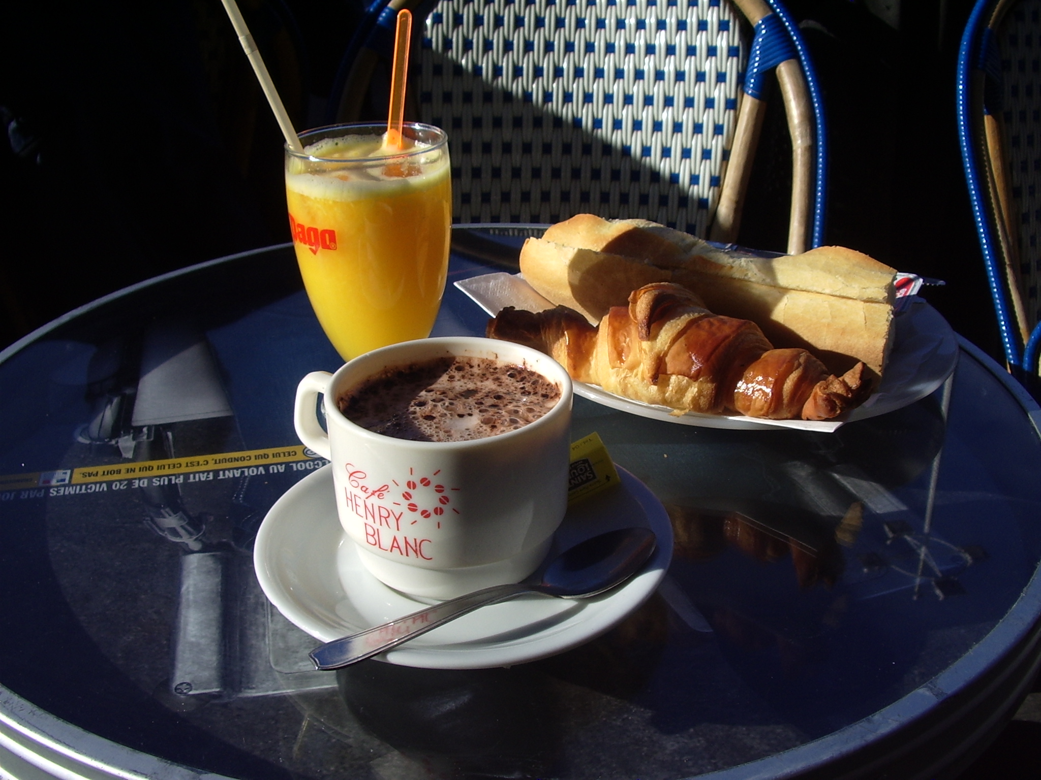
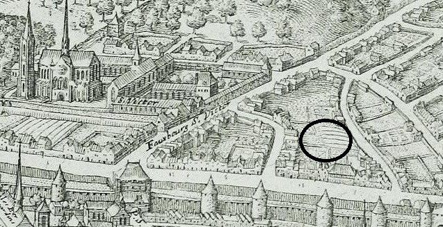
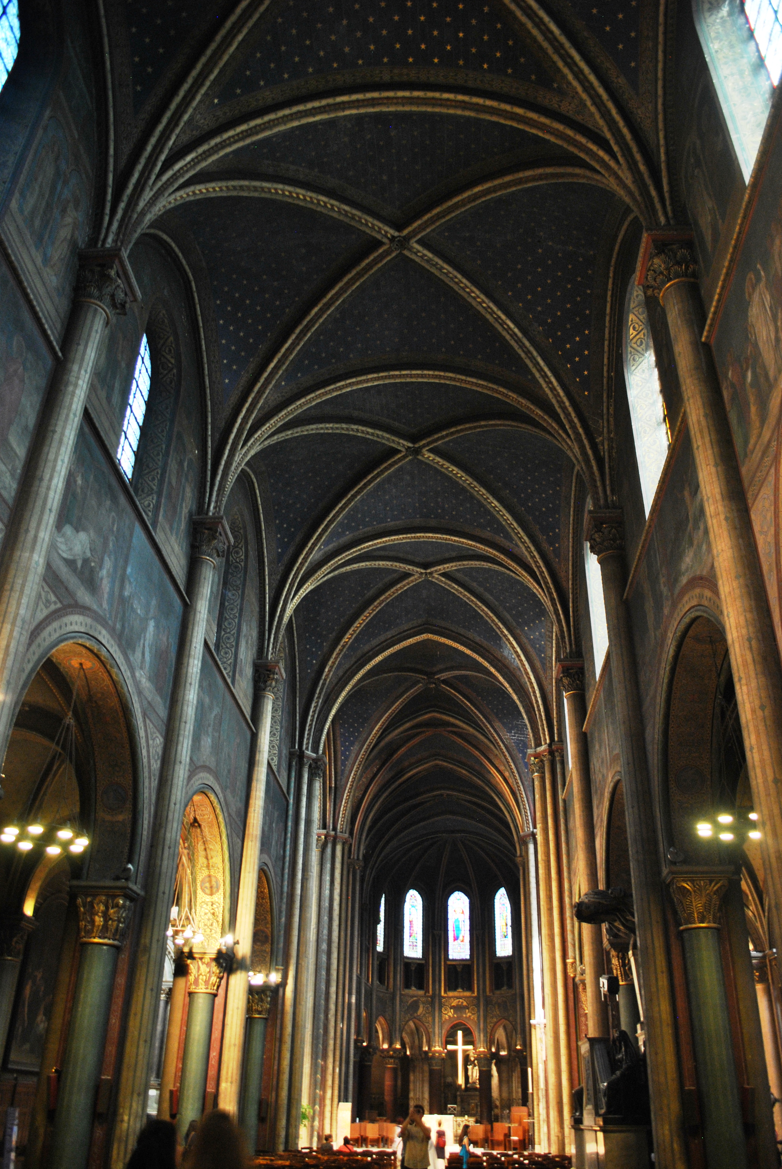
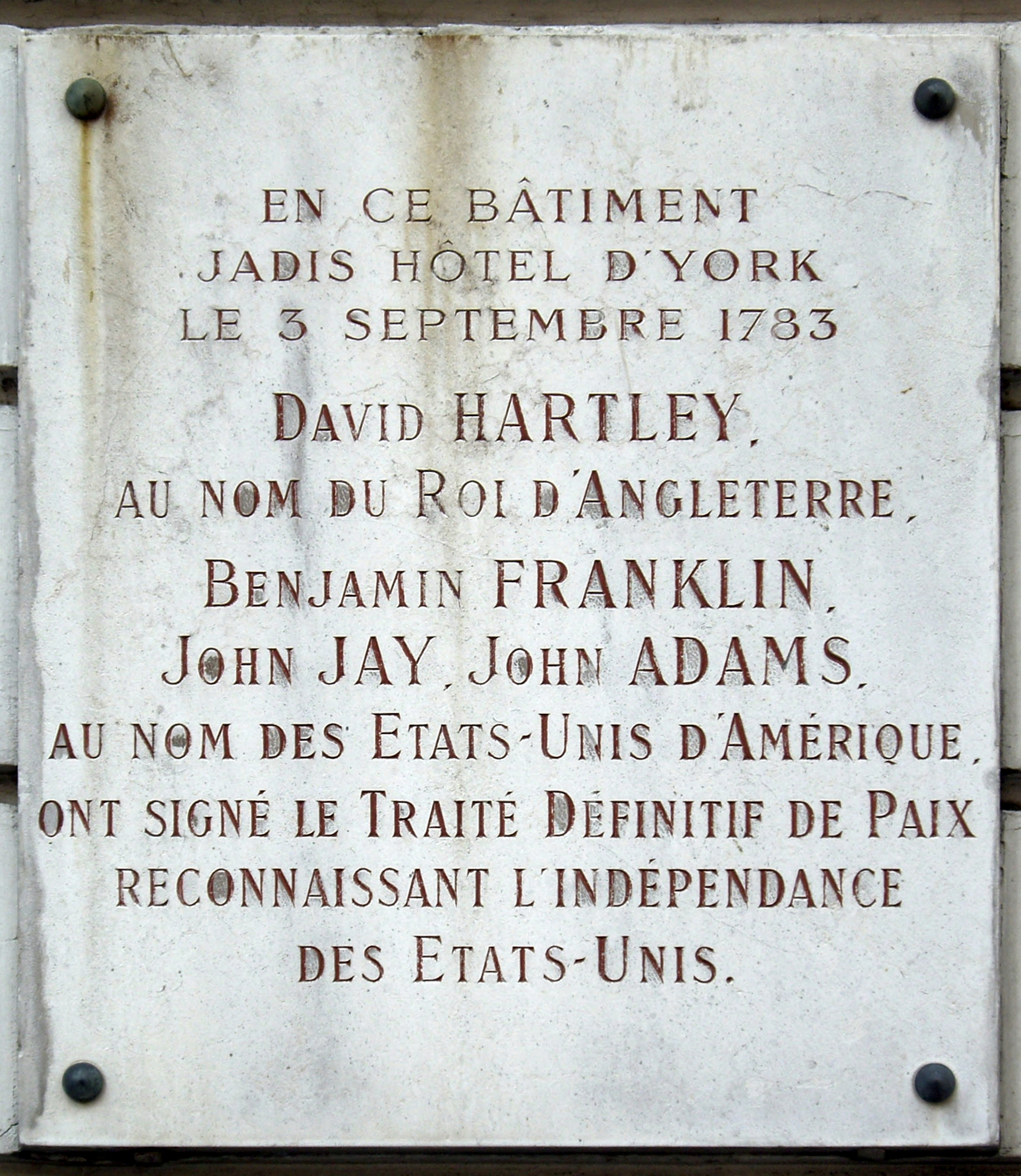
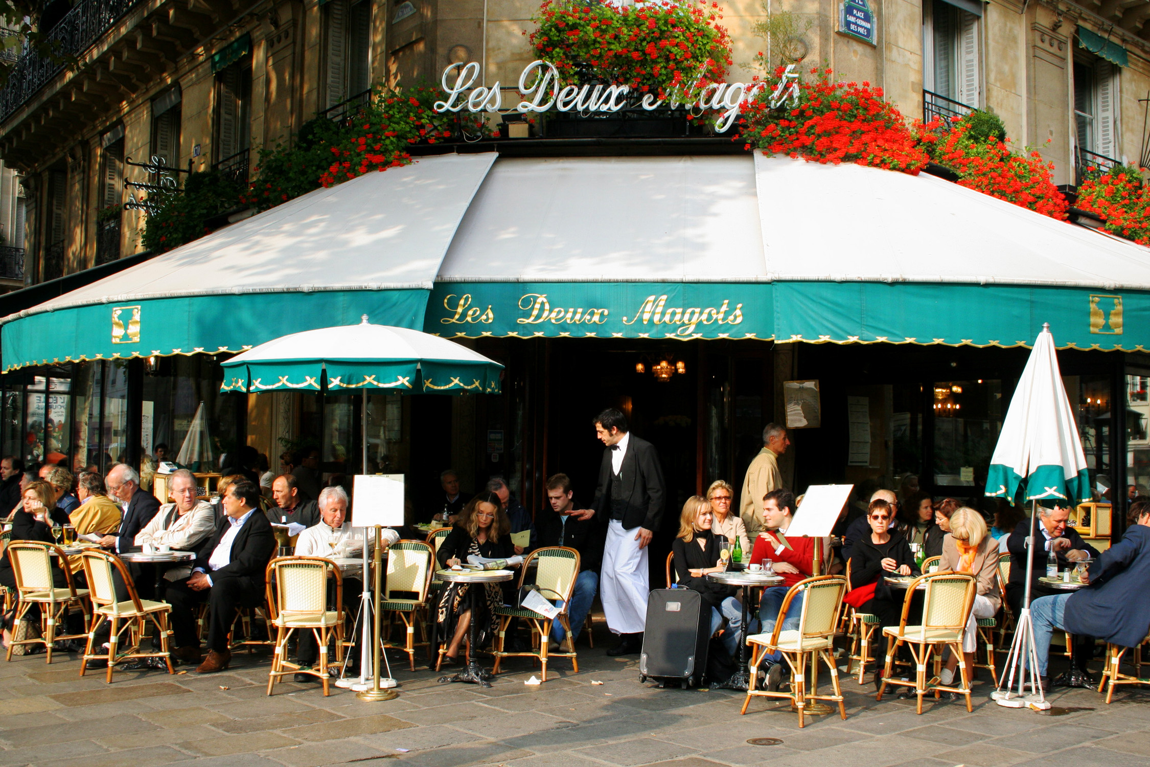
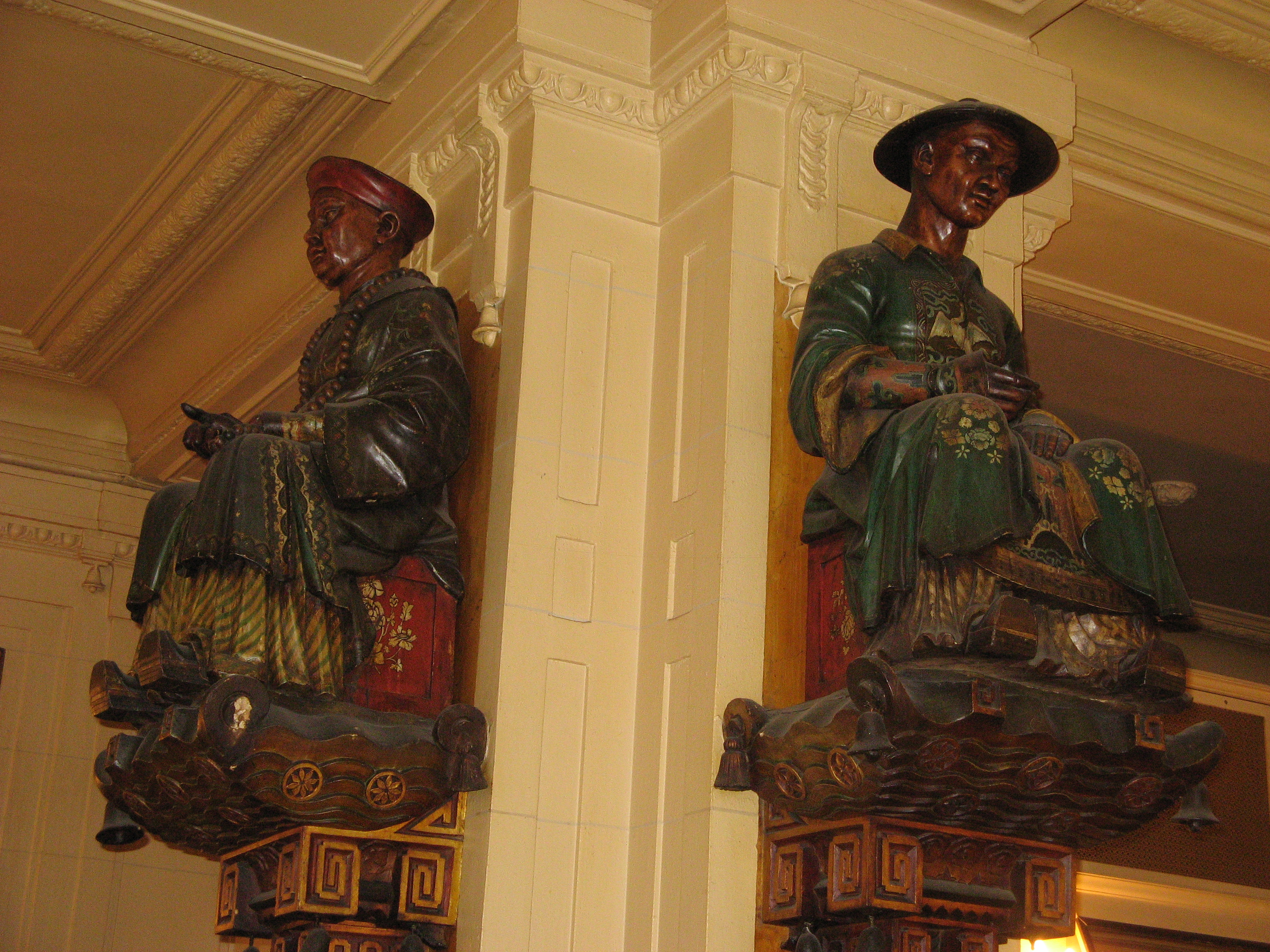
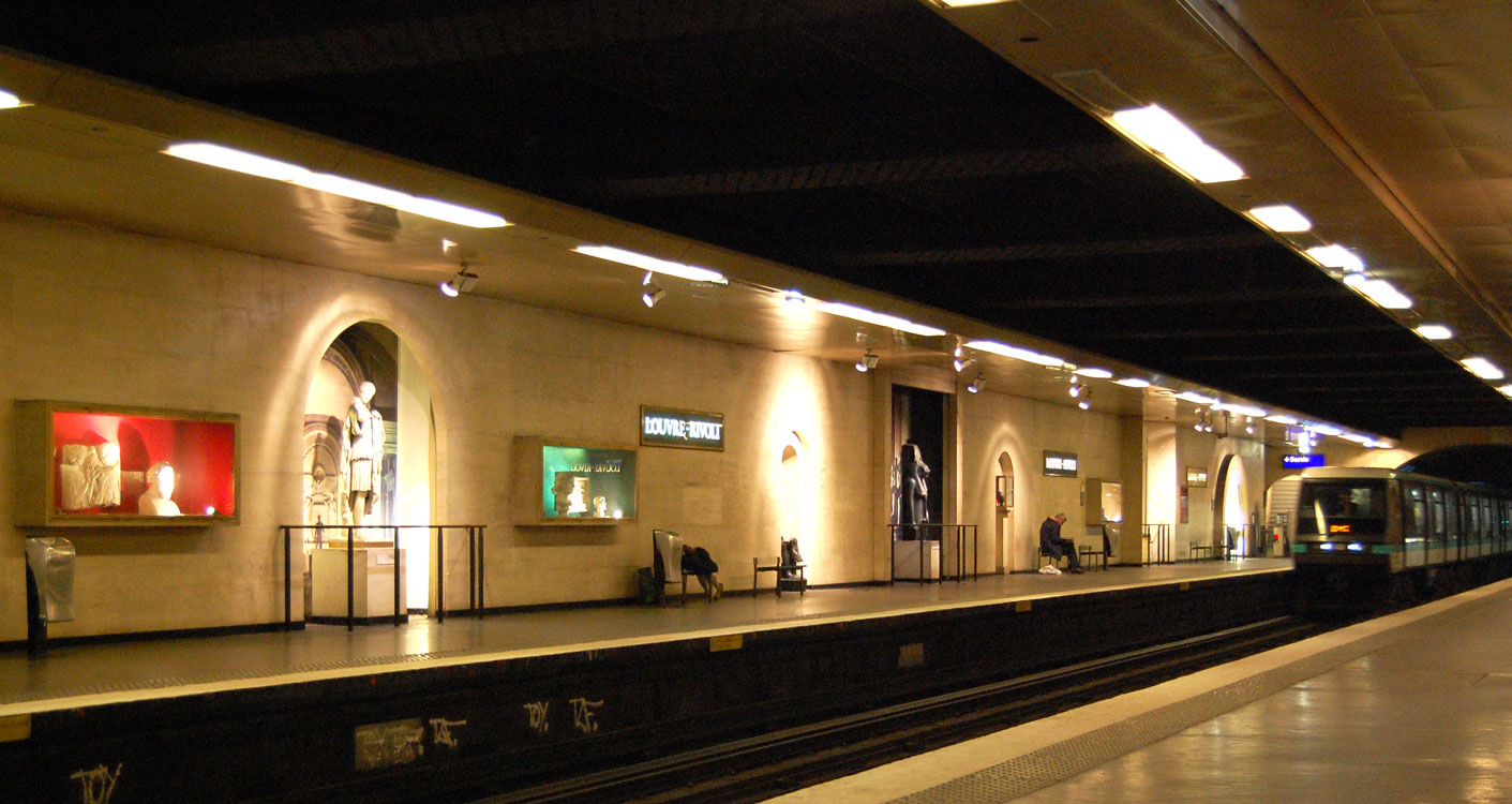